
Chapter F –Controls for Specific Sites & Locations
188
Controls for Specific Sites & Locations Chapter F Snowy River Development Control Plan 2013 1 Chapter F –Controls for Specific Sites & Locations Contents F1 Jindabyne Town Centre............................................................................................. 5 1. General Information ..................................................................................................... 6 1. Background ................................................................................................................... 6 2. Objectives ..................................................................................................................... 7 3. Controls ........................................................................................................................ 8 4.1 Urban Form ........................................................................................................... 8 4.2 Traffic, access, parking and servicing ................................................................... 14 4.3 Building and Site Design ...................................................................................... 16 4.4 Building Exterior .................................................................................................. 19 4.5 Open Space & Landscaping ................................................................................. 24 F2 Berridale Village Centre .......................................................................................... 27 1. General Information ................................................................................................... 27 1.1 Land to which this Chapter applies...................................................................... 27 1.2 Aim of this Chapter ............................................................................................. 28 1.3 Development Objectives for the Berridale Village Centre ................................... 28 2 Background and Context............................................................................................. 28 2.1 Context and Berridale Village Plan (2007) ........................................................... 28 2.2 Heritage Conservation......................................................................................... 29 3 Development & Design Controls ................................................................................. 30 3.1 Urban Form ......................................................................................................... 30 3.2 Traffic, access, parking and servicing................................................................... 34 3.3 Building and Site Design ...................................................................................... 35 3.4 Building Exterior .................................................................................................. 37 3.5 Open Space & Landscaping ................................................................................. 41 F3 Adaminaby Village Centre ....................................................................................... 43 1. General Information ................................................................................................... 45 1.1 Land to which this Chapter applies...................................................................... 45 1.2 Aim of this Chapter ............................................................................................. 45 1.3 Development Objectives for the Adaminaby Village Centre ............................... 45 2 Background & Context ................................................................................................ 46 2.1 Adaminaby Villages Plan ..................................................................................... 46 2.2 Heritage Conservation......................................................................................... 46 3. Development & Design Controls ................................................................................. 47
Transcript of Chapter F –Controls for Specific Sites & Locations

Controls for Specific Sites & Locations Chapter F
Snowy River Development Control Plan 2013
1
Chapter F –Controls for Specific Sites & Locations
Contents F1 Jindabyne Town Centre ............................................................................................. 5
1. General Information ..................................................................................................... 6
1. Background ................................................................................................................... 6
2. Objectives ..................................................................................................................... 7
3. Controls ........................................................................................................................ 8
4.1 Urban Form ........................................................................................................... 8
4.2 Traffic, access, parking and servicing ................................................................... 14
4.3 Building and Site Design ...................................................................................... 16
4.4 Building Exterior .................................................................................................. 19
4.5 Open Space & Landscaping ................................................................................. 24
F2 Berridale Village Centre .......................................................................................... 27
1. General Information ................................................................................................... 27
1.1 Land to which this Chapter applies...................................................................... 27
1.2 Aim of this Chapter ............................................................................................. 28
1.3 Development Objectives for the Berridale Village Centre ................................... 28
2 Background and Context ............................................................................................. 28
2.1 Context and Berridale Village Plan (2007) ........................................................... 28
2.2 Heritage Conservation ......................................................................................... 29
3 Development & Design Controls ................................................................................. 30
3.1 Urban Form ......................................................................................................... 30
3.2 Traffic, access, parking and servicing ................................................................... 34
3.3 Building and Site Design ...................................................................................... 35
3.4 Building Exterior .................................................................................................. 37
3.5 Open Space & Landscaping ................................................................................. 41
F3 Adaminaby Village Centre ....................................................................................... 43
1. General Information ................................................................................................... 45
1.1 Land to which this Chapter applies...................................................................... 45
1.2 Aim of this Chapter ............................................................................................. 45
1.3 Development Objectives for the Adaminaby Village Centre ............................... 45
2 Background & Context ................................................................................................ 46
2.1 Adaminaby Villages Plan ..................................................................................... 46
2.2 Heritage Conservation ......................................................................................... 46
3. Development & Design Controls ................................................................................. 47

Controls for Specific Sites & Locations Chapter F
2
Snowy River Development Control Plan 2013
3.1 Urban Form ......................................................................................................... 47
3.2 Traffic, access, parking and servicing ................................................................... 50
3.3 Building and Site Design ...................................................................................... 51
3.4 Building Exterior .................................................................................................. 53
3.5 Open Space & Landscaping ................................................................................. 56
F4 DALGETY ..................................................................................................................... 59
1 Planning for Future Character Design Guidelines ........................................................ 60
1.1 Character ............................................................................................................. 61
1.2 Setbacks .............................................................................................................. 62
1.3 Fences ................................................................................................................. 64
1.4 Curtilage .............................................................................................................. 65
2 Building Form.............................................................................................................. 66
2.1 Objectives ........................................................................................................... 66
2.2 Height and Scale .................................................................................................. 66
2.3 Massing ............................................................................................................... 67
2.4 Design ................................................................................................................. 67
2.5 Roofing ................................................................................................................ 68
2.6 Materials and Decoration .................................................................................... 69
2.7 Colours ................................................................................................................ 71
3 Landscaping ................................................................................................................ 72
3.1 Objectives ........................................................................................................... 72
3.2 Private Domain ................................................................................................... 72
3.3 Public Domain ..................................................................................................... 73
4 Amenity ...................................................................................................................... 74
4.1 Objectives ........................................................................................................... 74
4.2 Sunlight & Overshadowing .................................................................................. 74
4.3 Visual & Acoustic Privacy .................................................................................... 74
5 Alterations & Additions .............................................................................................. 75
5.1 Objectives ........................................................................................................... 75
5.2 Alterations .......................................................................................................... 75
5.3 Additions ............................................................................................................. 76
6 Conservation & Restoration ........................................................................................ 77
6.1 Objectives ........................................................................................................... 77
6.2 Conservation and Restoration ............................................................................. 77
F5 Ivy Cottage Estate (O’Brien Avenue) ....................................................................... 79
1. Background ................................................................................................................. 79
2. Location of Buildings ................................................................................................... 79
3. Height of Buildings ...................................................................................................... 80

Controls for Specific Sites & Locations Chapter F
3
Snowy River Development Control Plan 2013
4. Building Design, Materials and Finishes ...................................................................... 80
5. Restrictions to Use ...................................................................................................... 80
6. Fencing........................................................................................................................ 81
F6 Tyrolean Village (Rainbow Drive) ............................................................................ 82
1. Background ................................................................................................................. 82
2. Aims ............................................................................................................................ 82
3. Do Other Development Control Plans Apply To This Land? ........................................ 83
4. Ancillary Structures ..................................................................................................... 83
5. Building Envelopes ...................................................................................................... 83
6. Lot Amalgamation ...................................................................................................... 84
7. Building Design and Construction ............................................................................... 84
8. Parking and Vehicular Access ...................................................................................... 85
9. Landscaping ................................................................................................................ 85
10. Fencing .................................................................................................................... 86
F7 Highview Estate ...................................................................................................... 87
1 Introduction ................................................................................................................ 87
1.1 Vision .................................................................................................................. 87
1.2 Where this Chapter applies ................................................................................. 88
1.3 Aims .................................................................................................................... 88
1.4 Objectives ........................................................................................................... 89
1.5 Relationship with the LEP and Other Chapters .................................................... 89
1.6 How to Use this Chapter...................................................................................... 89
1.7 Site Context ......................................................................................................... 90
1.8 Proposed Development ....................................................................................... 91
2 Key Elements – Structure ............................................................................................ 92
2.1 Storm Water Management ................................................................................. 92
2.2 Water Sensitive Urban Design ............................................................................. 93
2.3 Landscaping ....................................................................................................... 100
2.4 Lot Layout ......................................................................................................... 101
2.5 Pedestrian and Cycle way network ................................................................... 101
2.6 Public Open Space ............................................................................................. 103
2.7 Biodiversity and Natural Resource Management .............................................. 104
2.8 Access, Traffic and Road Design ........................................................................ 105
2.9 Utilities .............................................................................................................. 109
2.10 Public Safety ...................................................................................................... 109
2.11 Archaeology ...................................................................................................... 110
3 Key Design Features – Residential Built Form ........................................................... 112
3.1 Site Analysis ...................................................................................................... 112

Controls for Specific Sites & Locations Chapter F
4
Snowy River Development Control Plan 2013
3.2 Site Planning and Layout ................................................................................... 112
3.3 Streetscape and Building Siting ......................................................................... 113
3.4 Building Heights ................................................................................................ 115
3.5 Site Coverage and Unbuilt Upon Areas ............................................................. 117
3.6 Private Outdoor Areas....................................................................................... 118
3.7 Building Form and Character ............................................................................. 119
3.8 Views, Visual and Acoustic Privacy .................................................................... 123
3.9 Solar Access ....................................................................................................... 126
3.10 Landscape Design .............................................................................................. 127
3.11 Fencing and Retaining Walls.............................................................................. 129
3.12 Car Parking and Vehicle Access ......................................................................... 131
3.13 Erosion and Sediment Control ........................................................................... 134
3.14 Cut and Fill ........................................................................................................ 134
3.15 Security, Site Facilities and Services .................................................................. 135
4 Additional Requirements for Residential Flat Buildings ............................................ 136
F8 Lakewood Estate ................................................................................................... 159
1. General ..................................................................................................................... 160
2. Subdivision ............................................................................................................... 160
3. Location of Buildings ................................................................................................. 160
4. Building Materials and Finishes ................................................................................ 161
5. Height of Buildings .................................................................................................... 161
6. Vehicular Access ....................................................................................................... 162
7. Drainage ................................................................................................................... 162
8. Water Supply ............................................................................................................ 163
9. Effluent Disposal ....................................................................................................... 163
10. Electricity .............................................................................................................. 163
11. Fencing .................................................................................................................. 164
12. Communal Facilities .............................................................................................. 164
13. Nature Conservation ............................................................................................. 164
14. Tree Preservation .................................................................................................. 165
15. Wildlife Protection ................................................................................................ 165
F9 Cobbin Creek Estate – Stages 1, 2 & 3 ................................................................... 167
1. Objectives ................................................................................................................. 168
2. Background ............................................................................................................... 168
3. Application of this Chapter ....................................................................................... 169
4. Development Controls .............................................................................................. 170
5. Tree Preservation ..................................................................................................... 170
6. Building Controls....................................................................................................... 170

Controls for Specific Sites & Locations Chapter F
5
Snowy River Development Control Plan 2013
7. Building materials and finishes ................................................................................. 170
8. Building Design and Height ....................................................................................... 171
9. Vehicular access ........................................................................................................ 172
10. Services ................................................................................................................. 172
11. Additional Uses ..................................................................................................... 173
12. Landscaping .......................................................................................................... 173
13. Environmental Protection ..................................................................................... 174
14. Dual Occupancy .................................................................................................... 175
15. Section 64 Contribution Payable ........................................................................... 175
16. Definitions ............................................................................................................ 176
F10 High Country Estate – Stages 1 & 2 ...................................................................... 183
1. Background ............................................................................................................... 184
2. Objectives ................................................................................................................. 184
3. Application of this Chapter ....................................................................................... 184
4. Development Controls .............................................................................................. 186
5. Tree Preservation ..................................................................................................... 186
6. Building Setbacks ...................................................................................................... 186
7. Restricted Building Areas .......................................................................................... 186
8. Building Materials and Finishes ................................................................................ 187
9. Building Design and Height ....................................................................................... 187
10. Vehicular Access ................................................................................................... 187
F1 Jindabyne Town Centre
Contents
1 General Information ....................................................................................................... 6
2 Background ..................................................................................................................... 6
3 Objectives ....................................................................................................................... 7
4 Controls .......................................................................................................................... 8
4.1 Urban Form ................................................................................................................. 8
4.2 Traffic, access, parking and servicing .......................................................................... 14
4.3 Building and Site Design ............................................................................................. 16
4.4 Building Exterior ........................................................................................................ 19
4.5 Open Space & Landscaping ........................................................................................ 24

Controls for Specific Sites & Locations Chapter F
6
Snowy River Development Control Plan 2013
1. General Information
This Chapter contains objectives and controls for development within the Jindabyne Town
Centre. In addition to the provisions of this Chapter, other controls apply to development in
the Jindabyne Town Centre as listed below and referenced throughout this Chapter.
Land to which this Chapter applies
This Chapter applies to all land in the Jindabyne Town Centre which is zoned B2 Local Centre
under the Snowy River LEP 2013 and shown on the map below.
1. Background
The role of the Jindabyne Town Centre as a focus for retail, community and tourism services
has influenced both its character and functioning. It is important that future development in
the Town Centre provides for a compact, strong and vibrant retail, tourism and community
core that serves the current and future needs of both the local community and visitors.
The area included in the Jindabyne Town Centre is zoned B2 Local Centre that allows for a
diverse range of commercial, retail and tourism development and residential apartments
above. The layout of the Town Centre currently experiences fragmentation due to the
historical development patterns of a number of large sites fronting Kosciusko Road with

Controls for Specific Sites & Locations Chapter F
7
Snowy River Development Control Plan 2013
activation of the retail and commercial area along Snowy River Avenue and Gippsland Street
needing improvement. A number of vacant sites also contributes to the fragmentation of the
streetscape. There are five key public car parks located throughout the Town Centre; the
adequacy of these parking areas has been assessed in the draft Jindabyne Parking Study.
The landscape setting of the Jindabyne Town Centre is one of its significant features and is
important for scenic, conservation and heritage values. The protection and management of
views from and to the Town Centre is an important consideration for all new development
to ensure that the scenic quality of the town is protected. Improved visual and physical
connections (trails) between landscaped areas of open space (parks and land reserves) and
the Town Centre will contribute to use and appreciation of the landscaped setting.
The future impacts on Jindabyne and the design and functioning of the Town Centre include
an ageing population, life stylists (tree changers), changes in tourism (growth in summer
tourism), impact of climate change and water levels of the Lake.
Jindabyne Town Centre Master Plan 2013
The layout of the Jindabyne Town Centre has been reviewed and improvements identified in
the Jindabyne Town Centre Master Plan including new community facilities, town square,
outdoor dining, landscaping and open space areas. The fragmentation of the Town Centre
has been considered in the Master Plan and future development sites have been identified
and the Master Plan has informed the Snowy River LEP 2013 in relation to height and floor
space ratio controls for the Town Centre.
The Master Plan also considers improved access arrangements for the Town Centre that will
provide safe and efficient pedestrian linkages between the existing commercial areas and
improved linkages between open space and recreational areas and adjoining residential
areas. A number of the provisions and controls included in this Chapter are based on the
recommendations of the Jindabyne Town Centre Master Plan.
Heritage Conservation
There are a number of heritage items listed in the Snowy River LEP 2013 that are located in
the Jindabyne Town Centre (refer to the LEP 2013 Heritage Maps for locations).
Information on the significance of these items and the individual heritage inventory sheets
can be obtained from Council. The Snowy River DCP also includes a specific Chapter
regarding development affecting a heritage item or on a site in the vicinity of a heritage item
(Chapter C4 Heritage).
It is highly recommended that an applicant meet with Council early in the design stages of a
proposal where development affects a heritage item.
2. Objectives
The objectives are to ensure that development:

Controls for Specific Sites & Locations Chapter F
8
Snowy River Development Control Plan 2013
reflects the outcomes of the Jindabyne Action Plan 2010, Jindabyne Growth Structure Plan 2007 and the Jindabyne Town Centre Master Plan;
provides for high quality retail, commercial, residential and tourism development which serves the needs of the local community and visitors to the area;
makes a positive contribution to the streetscape and that the scale, character and design of new development considers the existing neighbourhood within and adjacent to the Jindabyne Town Centre;
protects the natural and cultural heritage of Jindabyne and promotes a connection with important landmarks, significant views, areas of open space and Lake Jindabyne;
includes environmentally sustainable features; and
provides for equal access for all levels of mobility and enhances safety and security.
3. Controls
4.1 Urban Form
Views, vistas and landmarks
A view is a framed outlook that can be seen within a range of vision and vistas are distant,
wider views that often make a grand statement about a place. A view or vista can herald the
arrival to a place or reinforce a sense of location. Landmarks are distinctive and memorable
elements that connect people with place and time. Landmarks may include buildings,
building elements, parks, natural features and artworks. Landmarks in strategic locations can
provide visitors with direction from one point to another to navigate their way through town
centres.
The landscape setting of the Jindabyne Town Centre is one of its significant features and is
important for scenic, conservation and heritage values. The protection and management of
views and vistas from and to the Town Centre is an important consideration for all new
development to ensure that the scenic quality of the town is protected. Within the Town
Centre there are a number of existing and proposed sites for landmarks (squares and special
places) where a visual connection to and from the site should be retained.
Objectives
To protect and enhance views and vistas from and to the Jindabyne Town Centre which highlight the landscaped setting of the centre and improve legibility and reinforce a sense of place.
Controls
F1.1-1 Views, Vistas & Landmarks
(a) Significant views and vistas within the Town Centre, including those identified in the Jindabyne Town Centre Masterplan are to be maintained and enhanced (refer Landform and Views diagram below).
(b) Buildings are to be designed to maximise view sharing.

Controls for Specific Sites & Locations Chapter F
9
Snowy River Development Control Plan 2013
(c) Views from Lake Jindabyne and surrounding residential and rural areas are to be considered to ensure the visual amenity of these areas is protected.
Active site and street frontages
A successful commercial centre provides street level retail and commercial activities that
satisfy the requirements of local residents and visitors and enliven the public area by day
and night. Active frontage uses are defined as one of a combination of the following at
street level: entrance to retail or shopfront; café or restaurant if accompanied by an entry
from the street; and active office uses, such as reception, if visible from the street.
The Jindabyne Town Centre Masterplan and the Snowy River LEP 2013 (clause 7.9 Active
street frontages and accompanying mas) have identified the streets that are to include
Active Street Frontages (refer Snowy River LEP 2013 Active Street Frontages Map). The
Jindabyne Town Centre Master Plan has also identified additional Desirable Active Street
Frontages (refer figure below).
Objectives
To maximise active street frontages to encourage pedestrian activity and improve safety through passive surveillance.
To provide a range of uses to engage and activate the street. To maximise building openings and minimise the extent of blank walls on to the
street, especially at ground level. Controls
F1.1-2 Active Site & Street Frontages
(a) New buildings in the Town Centre are to provide continuous retail or active commercial uses on the ground floor.
(b) Restaurants, cafes and the like are to consider providing openable shop fronts. (c) Active ground floor uses are to be the same general level as the footpath and can be
readily accessible

Controls for Specific Sites & Locations Chapter F
10
Snowy River Development Control Plan 2013
(d) Street level activity is to be maximised by wrapping shopfronts around corners. (e) Building frontages are to encourage street level activity. (f) Minimise blank walls at ground level. (g) Maximise glazing for retail uses on the ground floors. (h) Do not use opaque or reflective glass on the ground floor (i) Use grilles or transparent security shutters with a minimum of 70% transparency on
retail frontages. Solid shutters are not permitted (j) Entrances to internally orientated shopping or commercial arcades, and the arcades
themselves must be a minimum of 7 metres wide.

Controls for Specific Sites & Locations Chapter F
11
Snowy River Development Control Plan 2013
Street corners
Buildings on street corners are important both in terms of ‘way finding’ and ‘place making’.
Well defined corners assist pedestrians to orientate and define their own position within a
precinct.
Objectives
To ensure that corner buildings, which by their location are often highly visible, are well designed and respond to the different characteristics of the streets they address.
To strengthen the way-finding attributes of corner properties and highlight the location of intersections.
Controls
F1.1-3 Street Corners
(a) Each frontage of a building on a corner site should be designed as a main street frontage.
(b) Development on corner sites should be designed to add variety and interest to the street and clarify the street hierarchy.
(c) The design of the development should emphasise verticality at corners, if possible by concentrating the tallest portion of the building on the corner itself.
(d) Design devices such as increased wall heights, splayed corner details, and other architectural features to reinforce the way finding attributes of street corners should be utilised where possible
Outdoor dining
Outdoor dining has an immediate positive impact on the vitality of places and creates street
level interest and variation. Outdoor dining may spill out from the restaurant’s main dining
area, be along the building wall or close to the kerb. In all instances, pedestrian movement
and street infrastructure should be a priority and not affected by new outdoor dining areas.
Council will consider other areas of outdoor dining where the objectives and performance
criteria below are satisfied.
Objectives
To encourage outdoor dining along streets and in public spaces to make the Jindabyne Town Centre lively during the day and night.
To increase casual and passive surveillance of the street to enhance safety and security.
Controls
F1.1-4 Outdoor Dining
(a) Consider incorporating areas of outdoor dining in café and restaurant developments where possible.
(b) The location of outdoor dining areas should provide good amenity, landscaping and outlook, solar access in the winter and shading in the summer and a traffic environment that can be calmed or supports outdoor dining usage.

Controls for Specific Sites & Locations Chapter F
12
Snowy River Development Control Plan 2013
(c) Lighting and heating should be provided for evening use of outdoor dining areas. (d) Outdoor dining areas should not take away from space used for street furniture or
interrupt utilities or other infrastructure. (e) Prioritise pedestrian flows and access for people with disabilities along main streets
by keeping the minimum clear width of footpath travel between the building and outdoor dining area.
(f) Along secondary streets with narrow footpaths or lanes, outdoor dining may be located discreetly along the wall of the building.
(g) Provide high quality and durable outdoor furniture of contemporary design and materials
Note: Refer to Chapter E3 Commercial Premises (Outdoor Dining & Trading).
Safety, security and crime prevention
Safety and security refers to formal and informal measures to protect properties, residents
and visitors. Developments should provide safe ground level entry and enable casual
surveillance.
Objectives
To encourage building design that provides casual surveillance of streets and other public areas.
To promote the design of buildings and open space areas which encourage community safety and reduce the opportunity for crime.
Controls
F1.1-5 Safety, security & crime prevention
(a) A formal crime risk assessment, consistent with the Department of Planning ‘Crime Prevention Through Environmental Design’ is to be carried out for certain types of development as specified by Council.
(b) Buildings must be designed to enable occupants to overlook streets and public open space to provide casual surveillance. Opportunities for casual surveillance should be provided by: orientating commercial and retail space and living areas (where residential
dwellings are located in the development), so they have views over public or commercial open spaces;
providing clear lines of sight between building and car park entrances and the street;
footpaths, landscaped areas and driveways must provide opportunities for surveillance and allow safe movement of residents around the site.
(c) Opportunities for concealment are to be minimised by: avoiding blind or dark alcoves near stairwells and lifts; providing well lit routes throughout the development; ensuring car parking areas, pathways and common areas of developments are
adequately lit at all times. (d) Entrances to buildings must be clearly visible and accessible from the street. (e) Community buildings and public open space areas are to be provided with sufficient
lighting and security. (f) The demarcation of public, communal and private areas in a development is to be
clearly recognisable.

Controls for Specific Sites & Locations Chapter F
13
Snowy River Development Control Plan 2013
(g) Large expanses of wall and fences which may attract graffiti are to be avoided. Note: refer to Chapter C2 Design (Crime Prevention Through Environmental Design) for
detailed controls.
Integrating large format uses/shopping centres
Shopping centres are traditionally stand-alone buildings inwardly focused onto a privately
owned central mall that contains a range of retail and other services. It is important for the
functioning of the Town Centre that these stand-alone shopping centres have both a visual
and direct connection to the Town Centre.
Objectives
To ensure that stand-alone shopping centres include a mix of uses and are integrated into the design and layout of the Town Centre.
Controls
F1.1-6 Integrating large format uses/shopping centres
(a) Integrate the internal and external layout of stand-alone shopping centres with the existing street network to improve walkability and legibility. Ensure pedestrian and cycle connections between the street network and the shopping centre are clear, direct, safe and attractive links that are well lit, with good signage and meet access requirements.
(b) Locate more intensive and extended-hour uses towards the street and around public spaces to ensure areas around the shopping centre are active at night and help with natural surveillance.
(c) Improve pedestrian access to shopping centres with entries that align with the street and existing connections. Pedestrian entries should be highly visible, connected to the public domain and easy to find.
(d) Design path and way finding signage to improve access, orientation and connections to spaces within and outside the shopping centre.
(e) Avoid long expanses of blank walls along street frontages or other public areas. (f) Provide active frontages to enable natural surveillance of public areas. (g) Provide bicycle parking close to shopping centre entries. (h) Ensure that service areas, site storage and loading bays are located away from public
spaces, streets and residential development.
Universal Design/Accessibility
The design of the public domain in the Town Centre should make it accessible to everyone,
including mobility impaired people, children, elderly citizens and pedestrians with prams.
Measures to make the public domain more accessible include adequate space so people can
easily move around, manageable slopes and grades in the street, ease of access to and from
building entrances, and tactile indicators and luminance contrast to help visually impaired
people. This ultimately encourages more people to use a space.
Objectives

Controls for Specific Sites & Locations Chapter F
14
Snowy River Development Control Plan 2013
To ensure that all residents and visitors, including wheelchair users and those with a disability are able to easily reach and enter all publicly accessible parts of a building.
Controls
F1.1-7 Universal Design/Accessibility
(a) Prioritise pedestrian flows for people with disabilities by providing a clear travel path along the building line.
(b) Where outdoor dining is provided along the wall of a building on secondary streets with narrow footpaths or lanes, access for people with a disability should be considered.
4.2 Traffic, access, parking and servicing
Vehicle Access and Parking
The location, type and design of vehicle access points to a development have a significant
impact on the streetscape, site layout and building design. It is important that vehicle access
is integrated with site planning from the earliest stages to minimise any potential conflicts
with pedestrians, streetscape requirements and traffic patterns.
Vehicle crossings over footpaths disrupt pedestrian movement and impact on safety. The
design of vehicle access to buildings also influences the quality of the public domain. Overly
wide vehicle access points detract from the streetscape and the active use of street
frontages.
Accommodating parking on site also has a significant impact on the site layout, landscape
design and stormwater management. The amount of parking provided is related the size of
the development, however parking provision should also be considered in relation to the
local context and the availability of car parking areas.
Objectives
To provide adequate and convenient car parking and service access for the development without compromising street character, landscape or pedestrian amenity and safety.
To minimise car dependency and to promote alternative means of transport including cycling and walking.
To integrate the location and design of car parking with the design of the site and the Jindabyne Town Centre.

Controls for Specific Sites & Locations Chapter F
15
Snowy River Development Control Plan 2013
Controls
F1.2-1 Vehicle access & parking
(a) Car parking provision and design is to be in accordance with Chapter C3 Car parking, traffic and access.
(b) Potential pedestrian and vehicle conflict is to be minimised by: ensuring clear sight lines at pedestrian and vehicle crossings; utilising traffic calming devices; separating and clearly distinguishing between pedestrian and vehicular
accessways (for example by using bollards, change of hard pavement in rear lane).
(c) Car parking areas are to include suitable landscaping, both within and on the perimeter of the car park, to improve appearance and provide shade.
(d) Where car parking is located within a development, the appearance of carparking and service vehicle entries are to be improved by: screening and locating garbage collection, loading and servicing areas within
the development; and avoiding black holes in the façade by providing security doors to carpark
entries. (e) Safe and secure access is to be provided for building users, including direct access for
residential apartments. (f) Parking and storage of bicycles (both resident and visitor) is to be provided at
convenient and secure locations. (g) Where doors are not provided to a car park, ensure that the visible interior of the car
park is incorporated into the façade design and material selection and that building services pipes and ducts are concealed.
(h) All vehicle access points to a development are to provide a minimum 1.5 metres landscaped setback to neighbouring properties.
Pedestrian and Cycle Access
Design for pedestrian access focuses on delivering high quality, safe and pleasant walking
environments. Pedestrian access and through-site links assist in ensuring that the
development is integrated into the locality and encourage ground level activity through the
site. Pedestrian access should also be equitable access, which provides a barrier-free
environment where all people who live in and visit the development can enjoy the public
domain.
The Jindabyne Town Centre Master Plan identifies the key pedestrian connections through
the Town Centre as shown below.
Objectives
To promote walking and cycling as modes of transport to improve health and wellbeing, reduce transport and infrastructure costs and minimise environmental impacts.
To ensure that development incorporates publicly accessible pedestrian paths that are well linked into the surrounding area.

Controls for Specific Sites & Locations Chapter F
16
Snowy River Development Control Plan 2013
Controls
F1.2-2 Pedestrian and cycle access
(a) All development is to provide high quality accessible routes to public and semi-public areas, including major entries, lobbies, communal open space, site facilities, parking areas and pedestrian pathways.
(b) All pedestrian links are to have appropriate levels of illumination. (c) All entrances to buildings are to be accessible from the street and are to integrate
ramps into the overall building and landscape design to promote equity of access. (d) Facilities for bicycle storage are to be provided in accordance with Chapter C3 Car
Parking, Traffic and Access. (e) All new developments are to consider including change room and shower facilities
for staff.
4.3 Building and Site Design
This section contains objectives and performance criteria and controls for building and site
design. Building height and density (FSR) requirements are contained in the Snowy River LEP
2013 and are explained in more detail below. Other requirements in this part include
setbacks and building articulation.
Building Height
Height is an important control because of its major impact on the character and physical and
visual amenity of a place. Height controls can be further refined by decisions about roof

Controls for Specific Sites & Locations Chapter F
17
Snowy River Development Control Plan 2013
form, amenity of adjacent residential areas, setting and topography and heritage context.
Building height also has a major impact on the degree of overshadowing and potential loss
of privacy and views.
Objectives
To ensure that building height relates to the context of the site, including street type, surrounding buildings, heritage items, landscape and views.
To allow reasonable daylight access to all development and the public domain including footpaths, areas of open space and the site of the Jindabyne Town Square.
To increase the amenity of the development by taking advantage of long distance views from the site.
To ensure appropriate management of overshadowing and privacy. Controls
F1.3-1 Height
Note: Maximum Building Heights are included in clause 4.3 of the Snowy River Local
Environmental Plan 2013.
(a) A minimum floor to ceiling height for ground level retail and commercial floorspace where active public uses are encouraged is 3.6 metres.
(b) A minimum floor to ceiling height of 3.0 metres is required for the upper level commercial floor space.
(c) A minimum floor to ceiling height of 2.7 metres is required for all residential floorspace.
Density / Floor Space Ratio
Building density is defined by maximum floor space ratio (FSR). The maximum FSR for sites
within the Jindabyne Town Centre are identified in clause 4.4 of the Snowy River LEP 2013.
The FSR control works in conjunction with the building height, setbacks and landscaped area
controls to identify the overall building envelope for the site. The achievement of the
maximum FSR is dependent on how the proposed development meets the objectives and
performance requirements of this Chapter and other relevant Chapters of the Snowy River
DCP.
In some instances it may not be possible to achieve the maximum allowable FSR for a
particular site, due to potential impacts on views, overshadowing and minimum landscaped
area requirements, and other design considerations.
Objectives
To control the bulk and scale of development. To ensure building bulk is compatible with the surrounding built form and
minimise the impact on existing buildings in the locality, open space and streetscape.
To define the allowable development density to ensure that development does not detrimentally impact on local traffic.
To encourage balconies and terraces within the development. Controls

Controls for Specific Sites & Locations Chapter F
18
Snowy River Development Control Plan 2013
F1.3-2 Density / Floor space ratio
(a) The maximum floor space ratio for the site is to be in accordance with the Snowy River LEP 2013 (clause 4.4 Floor Space Ratio).
(b) The area of terraces and balconies with outer walls of less than 1.4 metres high is not to be included in the calculation of floor space ratio in accordance with the Snowy River LEP 2013.
Setbacks
Setbacks reflect the character of an area and establish the development’s relationship with
the surrounding area. They create the relationship between neighbouring buildings,
opportunities for landscaped open space and are important contributors to visual and
acoustic privacy and daylight.
Street setbacks and front setbacks establish the development’s relationship with the
streetscape and character of the surrounding area. They create the address and proportions
of the street and contribute to the public domain by enhancing streetscape character
Setbacks within a development create the relationship between neighbouring buildings,
create opportunities for landscaped open space and are important contributors to visual and
acoustic privacy and daylight access. Minimal side setbacks encourage buildings to address
the street, rather than addressing side boundaries and adjacent buildings. This not only
contributes to privacy but increases passive surveillance of the street.
Objectives
To provide strong street edges in the Jindabyne Town Centre. To minimise the impact of development on adjoining land and to ensure
adequate separation between buildings. To provide adequate space for landscaping, visual and acoustic privacy and
solar access. To encourage the retention of significant views.
Controls
F1.3-3 Setbacks
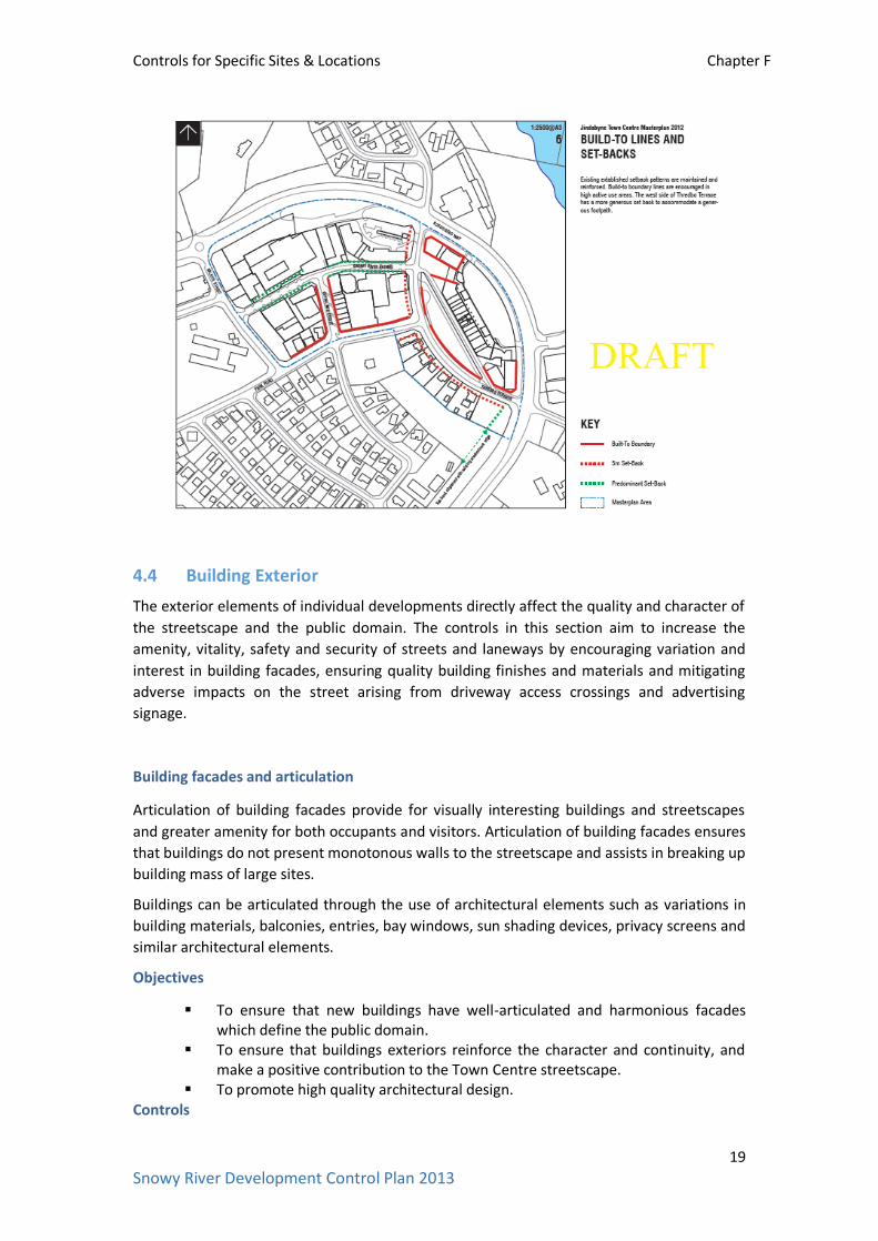
(a) The front setback requirements at ground level are shown in the Build to Lines and Setbacks figure in the Jindabyne Town Centre Master Plan (refer below).
(b) New buildings are to be sited and designed to form a strong, predominantly continuous built edge to the primary street frontage, Town Square and public parks and pathways. Where an allotments has frontage to two or more streets, the primary street frontage is the widest public street adjoining that allotment. Where an allotment has frontage to a street and public path or pathway, a strong, built edge is to be provided to both.
(c) All ground level setbacks are to be landscaped. (d) Vehicle access points and loading docks may be located within the setback area
where they do not have a detrimental impact on the appearance of the development or pedestrian and cycle movement.
Controls for Specific Sites & Locations Chapter F
19
Snowy River Development Control Plan 2013
4.4 Building Exterior
The exterior elements of individual developments directly affect the quality and character of
the streetscape and the public domain. The controls in this section aim to increase the
amenity, vitality, safety and security of streets and laneways by encouraging variation and
interest in building facades, ensuring quality building finishes and materials and mitigating
adverse impacts on the street arising from driveway access crossings and advertising
signage.
Building facades and articulation
Articulation of building facades provide for visually interesting buildings and streetscapes
and greater amenity for both occupants and visitors. Articulation of building facades ensures
that buildings do not present monotonous walls to the streetscape and assists in breaking up
building mass of large sites.
Buildings can be articulated through the use of architectural elements such as variations in
building materials, balconies, entries, bay windows, sun shading devices, privacy screens and
similar architectural elements.
Objectives
To ensure that new buildings have well-articulated and harmonious facades which define the public domain.
To ensure that buildings exteriors reinforce the character and continuity, and make a positive contribution to the Town Centre streetscape.
To promote high quality architectural design. Controls

Controls for Specific Sites & Locations Chapter F
20
Snowy River Development Control Plan 2013
F1.4-1 Building facades & articulation
(a) Buildings are to be designed to address the street and ensure that rear and side façades (where visible) also provide visual interest to the street and surrounding neighbours.
(b) The design of the development should include architectural features that give a human scale to the building, particularly at ground level.
(c) The design of the building façade, or a series of facades, should form a rhythm that complements and is harmonious with the streetscape.
(d) Building articulation should respond to the environmental conditions of the site including orientation, breezes and privacy.
(e) The maximum unarticulated building length is 9 metres along the primary street frontage and 10 metres along the secondary street frontage.
(f) All facades, including rear facades, must include windows. (g) Predominantly clear glazed shopfronts are to be provided to ground floor retail
development and for commercial development where the site is required to have an Active Street Frontage.
(h) Curtain walling, large expanses of glass and large expanses of concrete are to be avoided in the design of the building as these do not create well-articulated and harmonious facades.
(i) Grilles and transparent security shutters are to have a minimum of 70% transparency. Solid roller shutters, screens or grills on shopfronts and dwellings are not appropriate.
Building entrances
Building entrances define the threshold between the public street and private areas within
the building and contribute to the identity of the development. Where a building has a large
frontage to the street, multiple entries help to create a human scale along the street.
Objectives
To create building entrances which are clearly identifiable. To contribute positively to the streetscape and building façade design.
Controls
F1.4-2 Building entrances
(a) Building entries are to address the primary street frontage and form an integral part of the building façade.
(b) Building entries are to be clearly visible from the street, convenient for pedestrians, and a clearly identifiable element of the building.
(c) Building entries must be designed to have equal access to all people. (d) Safe and secure access is to be provided by providing a clear line of sight between
one circulation space and the next, providing sheltered, well lit and highly visible spaces for building entry and for the collection of mail.
(e) Separate entries from the street are to be provided for pedestrians and cars. (f) Entries and associated circulation spaces are to be of an adequate size to allow
movement of furniture between public and private spaces.
Solar access, overshadowing and natural daylight

Controls for Specific Sites & Locations Chapter F
21
Snowy River Development Control Plan 2013
Solar access forms an integral part of the design process and is a major determinant of
personal environmental comfort. Good passive solar design offers a resource and financial
benefit by reducing the need for artificial heating and cooling for commercial, retail and
residential development. New development must also recognise that existing adjacent
buildings require reasonable access to sunlight.
Objectives
To encourage passive solar design that minimises energy consumption. To minimise the negative impact of overshadowing on the internal and outdoor
areas of neighbouring buildings. To retain the amenity of the public domain by maximising solar access.
Controls
F1.4-3 Solar access, overshadowing & natural daylight
(a) Shadow diagrams, including elevations showing shadow impacts on any walls (and windows) of adjoining development and areas of open space must be submitted with the development application for all new buildings of two or more storeys. Any adverse overshadowing impact may require a reduction in the height or design changes of the proposed development.
(b) Solar access and overshadowing requirements for shop top housing are to be in accordance with Chapter D1 Residential Accommodation.
(c) The height and design of buildings should not significantly impact on sunlight access or overshadow public open spaces, outdoor dining areas and the Town Square.
Awnings
Awnings increase the useability and amenity of public footpaths by protecting pedestrians
from weather. They encourage pedestrian activity and contribute to the identity of a
development. Awnings also offer a good opportunity to create architectural detail and
contribute to the character of the street.
Objectives
To provide shelter for areas where pedestrian activity occurs. To reinforce an existing coordinating feature of the Jindabyne Town Centre. To provide continuity in the streetscape.
Controls
F1.4-4 Awnings
(a) Continuous awnings are to be provided on the main pedestrian activity paths and areas identified as having Active Street Frontages (refer Snowy River LEP 2013 – Active Street Frontages Map).
(b) Awnings over a public footpath are to be: a minimum clear height of 3 metres above the footpath; a depth of 2 metres where non-residential uses adjoin; not less than 600mm from the edge of the road/kerb.
(c) Along streets with existing awnings, any new awnings are to be aligned with the existing and are to be designed to be complimentary with the existing.
(d) Under awning lighting is to be provided to facilitate night use of the footpath and to improve public safety.

Controls for Specific Sites & Locations Chapter F
22
Snowy River Development Control Plan 2013

Controls for Specific Sites & Locations Chapter F
23
Snowy River Development Control Plan 2013
Signage and advertising
Signage and advertising plays a significant part in identifying retail and commercial uses and
in creating a lively retail strip. It is important that signage in the Town Centre is clear and
easily understood, integrated into the design of new buildings and consistent with the
streetscape character.
Objectives
To ensure that signage is in keeping with the development in scale and quality. To enhance the visual quality of the streetscape.
Controls
F1.4-5 Signage & advertising
(a) Advertising signs are to be in accordance with Chapter C6 Advertising and Signage. (b) The location, size and design for signage associated with a development is to be
included in the development application plans and elevations. (c) The location and design of signage and advertising is not to:
obscure important architectural features or dominate the architecture of buildings
protrude from the awnings project above any part of the building to which it is attached cover a large portion of the building façade
(d) Fin signs, projecting wall signs and roof signs are not permitted. (e) Commercial signage on local shops is to be limited to identification signs with one
sign permitted for each shop front. These may be located on shop front windows, above entrances or suspended under colonnades or awnings in accordance with Chapter C6 Advertising and Signage.
Materials and finishes
The selection of appropriate materials and finishes for development within the Jindabyne
Town Centre is important because of the sites prominent position on Lake Jindabyne and it
function as the main centre for both local community and visitors. In addition, the range of
weather conditions makes the selection of building materials and finishes important for both
the appearance and longevity of the development. It is also important to consider the
environmental impacts of materials in terms of their whole life cycle (including their
manufacture and disposal) when selecting construction and building materials, fittings,
fixtures and appliances.
Objectives
To ensure that new development in the Town Centre achieves a high standard of architectural character and include quality finishes.
To ensure that building materials and finishes contribute to a stylish and coherent streetscape.
To ensure that colours and materials are selected to aesthetically relate to the Snowy River environment.
To ensure building materials are chosen that can withstand climatic variations and extremes.
To encourage the use of recycled and environmentally sustainable materials.

Controls for Specific Sites & Locations Chapter F
24
Snowy River Development Control Plan 2013
Controls
F1.4-6 Materials and finishes
(a) New development is to utilise high quality and durable materials and finishes. (b) The exterior finishes of new development is to include earthy colour schemes
consistent with the Snowy River Design Guidelines and avoid corporate and bright colours that are inconsistent with the character of the Jindabyne Town Centre streetscape.
(c) Materials and finishes are to be in accordance with the Snowy River Design Guidelines .
(d) The facades of new development is to include a variety of materials and finishes and avoid large expanses of any single material
4.5 Open Space & Landscaping
Open space
Open space is a critical environmental feature as well as ‘breathing space’ for the Town
Centre. It may be public (assessable and usable by the general public), communal (shared by
all occupants of a development) or private (for the exclusive use of the occupants).
Generally, open space in the Town Centre is provided as public open space.
The primary function of open space is to provide amenity in the form of: landscape design,
opportunities for recreation and social activities, daylight access for neighbouring sites,
visual privacy, and water cycle management. Within individual sites, the size, location and
design treatment of open space will vary depending on the context of the site, proposed
uses and scale of development.
Objectives
To provide areas of passive open space within the Jindabyne Town Centre. To ensure that communal space is consolidated, configured and designed to be
useable and attractive. To provide a pleasant landscaped outlook from and to the Jindabyne Town
Centre. Controls
F1.5-1 Open space
(a) The amount of open space provided on a site is to be in accordance with the requirements for the type of development proposed (eg. Chapter D1 Residential Accommodation).
(b) Publicly accessible open space is to be located so that it forms a focus of the development and provides a landscape buffer between buildings and provides for a pleasant outlook.
(c) Publicly accessible open space should be consolidated into useable areas and demonstrate that its size and dimensions allow for a variety of uses.
(d) Open space should be located so that solar access is maximised.

Controls for Specific Sites & Locations Chapter F
25
Snowy River Development Control Plan 2013
Landscape design
Landscape design and maintenance plays an important role in determining the character of
the Town Centre. The use of local native plant species in landscape design is encouraged as
they generally require less water and are suited to the local climatic conditions.
Objectives
To ensure that landscaping is integrated into the design of the development and is consistent with the landscape character of the streetscape.
To add value within a development by providing privacy, outlook and landscaped views.
To promote sustainable landscape design and irrigation practices. To ensure landscape design takes into account the site’s microclimate. To maximise absorptive landscaped areas for on-site infiltration of stormwater.
Controls
F1.5-2 Landscape design
(a) All development applications are to include a landscape plan (refer Chapter A2 Development Application Requirements).
(b) Landscape design is to be in scale with the development and should relate to building form, facilitate stormwater infiltration through the use of permeable surfaces, and be easily maintained.
(c) Landscaping is to ensure amenity of private and publicly accessible open spaces by providing: shade from the sun and shelter from the wind; accessible and safe routes through the space and between buildings.
(d) Landscape design is to improve the energy and solar efficiency of development and the microclimate of open spaces by: locating trees for shading low-angle sun on the eastern and western sides of
buildings; using deciduous trees (where appropriate) for shading of windows and open
space areas in summer and allowing solar access in winter. (e) Landscape design is to minimise water consumption by including local native plants
with low water demand (refer Recommended Species for Landscaping – Chapter C5) and using plants with low fertiliser requirements.
(f) The landscape plan must outline how landscaped areas are to be maintained for the life of the development
Deep soil zones
Deep soil zones are areas of natural ground, and with relatively natural soil profiles, retained
within a development and not built upon. Deep soil zones have important environmental
benefits including: promoting healthy growth of large trees with large canopies; protecting
existing mature trees; and allowing infiltration of rainwater and reducing stormwater runoff.
Objectives
To improve the amenity of development through the retention and planting of trees that are, or will, grow to a large or medium size.
To assist with management of water quality and the water table. Controls

Controls for Specific Sites & Locations Chapter F
26
Snowy River Development Control Plan 2013
F1.5-3 Deep soil zones
(a) The development, where possible, is to include deep soil zones which will accommodate existing mature trees as well as allow for the planting of trees/shrubs that will grow to be mature trees.
(b) Deep soil zones are to have a pervious surface. (c) Deep soil zones are not to be built upon.

Controls for Specific Sites & Locations Chapter F
27
Snowy River Development Control Plan 2013
F2 Berridale Village Centre
Contents
1 General Information ..................................................................................................... 27
1.1 Land to which this Chapter applies ............................................................................. 27
1.2 Aim of this Chapter .................................................................................................... 28
1.3 Development Objectives for the Berridale Village Centre ........................................... 28
2 Background and Context ............................................................................................... 28
2.1 Context and Berridale Village Plan (2007) ................................................................... 28
2.2 Heritage Conservation ................................................................................................ 29
3 Development & Design Controls ................................................................................... 30
3.1 Urban Form ................................................................................................................ 30
3.2 Traffic, access, parking and servicing .......................................................................... 34
3.3 Building and Site Design ............................................................................................. 35
3.4 Building Exterior ......................................................................................................... 37
3.5 Open Space & Landscaping ........................................................................................ 41
1. General Information
1.1 Land to which this Chapter applies
This Chapter applies to the Berridale Village Centre which includes land in Berridale zoned
RU5 Village under the Snowy River LEP 2013 and shown on the map below.
REFER TO BERRIDALE VILLAGE CENTRE BOUNDARY
SEPARATE MAPS – OPTION 3
The provisions of Chapter D1 Residential Accommodation also apply to development for
residential accommodation in the Berridale Village Centre. Where there is an inconsistency
between Chapter D1 and this Chapter, the provisions of this Chapter will prevail.

Controls for Specific Sites & Locations Chapter F
28
Snowy River Development Control Plan 2013
1.2 Aim of this Chapter
The aim of this Chapter is to produce objectives and detailed development controls to guide
the built form, environmental and amenity standards for development within the Berridale
Village Centre.
1.3 Development Objectives for the Berridale Village Centre
The objectives for development in the Berridale Village Centre are to ensure that
development:
reflects the values and outcomes of the Berridale Village Plan (2007); provides for high quality retail, commercial, residential and tourism development
which promotes vitality in the Village Centre and serves the needs of both the local community and visitors to the area;
provides for a mix of uses which support a sustainable level of growth without adversely impacting on the heritage values and the village character;
makes a positive contribution to the streetscape with the scale, character and design of new development considering the existing neighbourhood within and adjacent to the Berridale Village Centre, the rural setting of the village and its connection to the mountains;
protects the natural and cultural heritage of Berridale and promotes a connection with important landmarks, significant views and areas of open space;
includes environmentally sustainable features; and provides for equal access for all levels of mobility and enhances safety and security.
2 Background and Context
2.1 Context and Berridale Village Plan (2007)
The Village Centre of Berridale defined in the Berridale Village Plan includes the commercial
and service core with a concentration of specialty shops, cafes, pub, garage and offices
including the Council Chambers. There is a range of building styles (one and two storey) with
a number of the buildings heritage listed, providing heritage character to parts of the Village
Centre.
Two large parking areas within the Village Centre are dominant features that separate the
Jindabyne Road frontage from the shopfronts. These parking areas could be enhanced with
further landscaping and use of materials to be both functional and welcoming as a focal
point of the village.
The open space network and landscaping are also central to Berridale’s character and are
widely recognised as assets for both residents and visitors. Significant areas of landscaped
open space, located on the eastern side of Jindabyne Road, provide a distinct character to
the Village Centre. Improving landscaping is a key way to enhance the character of the
village and making the village more attractive and desirable.

Controls for Specific Sites & Locations Chapter F
29
Snowy River Development Control Plan 2013
The key existing characteristics of the Village Centre identified in the Berridale Village Plan
(2007) are:
commercial core with shops, cafes, restaurants, offices and services; established landscaping in pockets; variety of signage; mix of building scale and styles; and heritage streetscape.
The Berridale Village Plan also included a ‘Preferred Character Statement’ for the Centre
(identified as Precinct No.6) being:
“The attractiveness and functioning of this area will be maintained and strengthened by:
encouraging good design that creates a functional and attractive commercial core; supporting a range of development that is geared toward service provision and
commercial activities; and encouraging landscaping to break built form and enhance the character of the
village.”
The Berridale Village Plan also identified features to avoid including:
large inappropriate signage that dominates the area and detracts from the heritage and low key village centre; and
buildings that do not present or address the street frontage.
2.2 Heritage Conservation
There are a number of heritage items listed in the Snowy River LEP 2013 that are located in
the Berridale Village Centre (refer Snowy River LEP 2013 Heritage Maps).
In addition to heritage buildings, the Snowy River LEP 2013 also identifies the cultural
streetscape along Jindabyne Road, Berridale as a heritage and includes a remnant row of
Lombardy poplars and radiata pines interspersed with hawthorn hedging at the northern
entrance to Berridale and an avenue of Lombardy poplar that line the southern entrance to
village and a grove of cypress defining the War Memorial Site. The statement of significance
notes that:
The street trees spatially define both the northern and southern entrances to
Berridale and are known to be one of the main features of the town. The use
of radiata pines, Lombardy poplars and hawthorns is representative of early
20th Century street planting. They make an important contribution to the
streetscape and the character of the town.
The radiata pines were planted around 1902 and the Lombardy poplars
during the Inter War period. The milestones were relocated to the site c1960.
Information on the significance of these items and the individual heritage inventory sheets
can be obtained from Council. This DCP also includes a specific Chapter for development
affecting a heritage item or on a site in the vicinity of a heritage item (Chapter C4 Heritage).

Controls for Specific Sites & Locations Chapter F
30
Snowy River Development Control Plan 2013
It is highly recommended that an applicant meet with Council early in the design stages of a
proposal where development affects a heritage item.
3 Development & Design Controls
3.1 Urban Form
Views, Vistas and Landmarks
The landscape setting of the Berridale Village Centre is one of its significant features and is
important for scenic, conservation and heritage values. The protection and management of
views and vistas from and to the Village Centre is an important consideration for all new
development to ensure that the scenic and landscape quality of Berridale is protected.
Objectives
To protect and enhance views and vistas from and to the Berridale Village Centre which highlight the landscaped setting, heritage features and character of the centre.
Controls
F2.1-1 Views, vistas & landmarks
Significant views and vistas within the Village Centre are to be maintained and enhanced including views to and from surrounding village and rural areas. Buildings are to be designed to maximise view sharing.
Active Site and Street Frontages
A successful village centre provides street level retail and commercial activities that satisfy
the requirements of local residents and visitors and enliven the public area by day and night.
Active frontage uses at street level include entrances to retail or shopfront; café or
restaurant and active office uses, such as reception areas, if visible from the street.
Objectives
To maximise active street frontages to encourage pedestrian activity and improve safety through passive surveillance.
To provide a range of uses to engage and activate the street.
To maximise building openings and minimise the extent of blank walls on to the street, especially at ground level.
Controls
F2.1-2 Active site & street frontages
(a) Provide continuous retail or active commercial frontage on the ground floor of buildings within the Berridale Village Centre.
Active ground floor uses are to be the same general level as the footpath and can be readily accessible.
Restaurants, cafes and the like are to consider providing openable shop fronts.

Controls for Specific Sites & Locations Chapter F
31
Snowy River Development Control Plan 2013
Street level activity is to be encouraged and maximised by wrapping shopfronts around corners.
Blank walls at ground level are to be minimised.
Maximise glazing for retail uses on the ground floors.
Opaque or reflective glass is not to be used on the ground floor facade.
Use grilles or transparent security shutters with a minimum of 70% transparency on retail frontages. Solid shutters are not permitted.
Entrances to internally orientated shopping or commercial arcades, and the arcades themselves must be a minimum of 7 metres wide.
Street Corners
Buildings on street corners are important both in terms of ‘way finding’ and ‘place making’.
Well defined corners assist pedestrians to orientate and define their own position within a
precinct.
Objectives
To ensure that corner buildings, which by their location are often highly visible, are well designed and respond to the different characteristics of the streets they address.
Controls
F2.1-3 Street corners
(a) Each frontage of a building on a corner site should be designed as a main street frontage.
(b) On corner sites street level activity is to be maximised by wrapping shopfronts around corners.
(c) Development on corner sites should be designed to add variety and interest to the street and clarify the street hierarchy.
(d) Development on corner sites should utilise design devices such as increased wall heights, splayed corner details, and other architectural features to reinforce the way finding attributes of street corners.
Outdoor Dining
Outdoor dining has an immediate positive impact on the vitality of places and creates street
level interest and variation. Outdoor dining may spill out from the restaurant’s main dining
area, be along the building wall or close to the kerb. In all instances, pedestrian movement
and street infrastructure should be a priority and not affected by new outdoor dining areas.
Objectives
To encourage outdoor dining along streets and in public spaces to make the Berridale Village Centre lively during the day and night.
To increase casual and passive surveillance of the street to enhance safety and security.
Controls
F2.1-4 Outdoor dining

Controls for Specific Sites & Locations Chapter F
32
Snowy River Development Control Plan 2013
(a) Consider incorporating areas of outdoor dining in café, take away food and drink premises and restaurant developments where possible.
The location of outdoor dining areas should provide good amenity, landscaping and outlook, solar access in the winter and shading in the summer and a traffic environment that can be calmed or supports outdoor dining usage.
Lighting and heating should be provided for evening use of outdoor dining areas.
Outdoor dining areas should not take away from space used for street furniture or interrupt utilities or other infrastructure.
Prioritise pedestrian flows and access for people with disabilities along main streets by keeping the minimum clear width of footpath travel between the building and outdoor dining area.
Note: Refer to Chapter E3 Commercial Premises (Outdoor Dining & Trading).
Safety, Security and Crime Prevention
Safety and security refers to formal and informal measures to protect properties, residents
and visitors. Developments should provide safe ground level entry and enable casual
surveillance.
Objectives
To encourage building design that provides casual surveillance of streets and other public areas.
To promote the design of buildings and open space areas which encourage community safety and reduce the opportunity for crime.
Controls
F2.1-5 Safety, security & crime prevention
(a) A formal crime risk assessment, consistent with the Department of Planning ‘Crime Prevention Through Environmental Design’ is to be carried out for certain types of development as specified by Council.
(b) Buildings must be designed to enable occupants to overlook streets and public open space to provide casual surveillance. Opportunities for casual surveillance should be provided by:
orientating commercial and retail space and living areas (where residential dwellings are located in the development), so they have views over public or commercial open spaces;
providing clear lines of sight between building and car park entrances and the street;
footpaths, landscaped areas and driveways must provide opportunities for surveillance and allow safe movement of residents around the site.
(c) Opportunities for concealment are to be minimised by:
avoiding blind or dark alcoves near stairwells;
providing well lit routes throughout the development;
ensuring car parking areas, pathways and common areas of developments are adequately lit at all times.
(d) Entrances to buildings must be clearly visible and accessible from the street.

Controls for Specific Sites & Locations Chapter F
33
Snowy River Development Control Plan 2013
(e) Community buildings and public open space areas are to be provided with sufficient lighting and security.
(f) Large expanses of wall and fences, which may attract graffiti, are to be avoided.
Note: refer to Chapter C2 Design (Crime Prevention Through Environmental Design) for
detailed controls.
Integrating large format uses/shopping centres
Shopping centres are traditionally stand-alone buildings inwardly focused onto a privately
owned central mall that contains a range of retail and other services. It is important for the
functioning of the Village Centre that these stand-alone shopping centres have both a visual
and direct connection to the Village Centre.
Objectives
To ensure that stand-alone shopping centres include a mix of uses and are integrated into the design and layout of the Village Centre.
Controls
F2.1-6 Integrating large format uses/shopping centres
(a) Integrate the internal and external layout of stand-alone shopping centres with the existing street network to improve walkability and legibility. Ensure pedestrian and cycle connections between the street network and the shopping centre are clear, direct, safe and attractive links that are well lit, with good signage and meet access requirements.
(b) Locate more intensive and extended-hour uses towards the street and around public spaces to ensure areas around the shopping centre are active at night and help with natural surveillance.
(c) Improve pedestrian access to shopping centres with entries that align with the street and existing connections. Pedestrian entries should be highly visible, connected to the public domain and easy to find.
(d) Design path and way finding signage to improve access, orientation and connections to spaces within and outside the shopping centre.
(e) Avoid long expanses of blank walls along street frontages or other public areas. Provide active frontages to enable natural surveillance of public areas.
(f) Provide bicycle parking close to shopping centre entries. (g) Ensure that service areas, site storage and loading bays are located away from public
spaces, streets and residential development.
Universal Design/Accessibility
The design of the public domain in the Village Centre should make it accessible to everyone,
including mobility impaired people, children, elderly citizens and pedestrians with prams.
Measures to make the public domain more accessible include adequate space so people can
easily move around, manageable slopes and grades in the street, ease of access to and from
building entrances, and tactile indicators and luminance contrast to help visually impaired
people. This ultimately encourages more people to use a space.
Controls for Specific Sites & Locations Chapter F
34
Snowy River Development Control Plan 2013
Objectives
To ensure that all residents and visitors, including wheelchair users and those with a disability are able to easily reach and enter all publicly accessible parts of a building.
Controls
F2.1-7 Universal design/accessibility
(a) Prioritise pedestrian flows for people with disabilities by providing a clear travel path along the building line.
(b) Where outdoor dining is provided along the wall of a building on secondary streets with narrow footpaths or lanes, access for people with a disability should be considered.
3.2 Traffic, access, parking and servicing
Vehicle Access and Parking
The location, type and design of vehicle access points to a development have a significant
impact on the streetscape, site layout and building design. It is important that vehicle access
is integrated with site planning from the earliest stages to minimise any potential conflicts
with pedestrians, streetscape requirements and traffic patterns.
Vehicle crossings over footpaths disrupt pedestrian movement and impact on safety. The
design of vehicle access to buildings also influences the quality of the public domain. Overly
wide vehicle access points detract from the streetscape and the active use of street
frontages.
Accommodating parking on site also has a significant impact on the site layout, landscape
design and stormwater management. The amount of parking provided is related the size of
the development, however parking provision should also be considered in relation to the
local context and the availability of car parking areas.
Objectives
To provide adequate and convenient car parking and service access for the development without compromising street character, landscape or pedestrian amenity and safety.
To minimise car dependency and to promote alternative means of transport including cycling and walking.
To integrate the location and design of car parking with the design of the site and the Berridale Village Centre.
Controls
F2.2-1 Vehicle access & parking
(a) Carparking provision and design is to be in accordance with Chapter C3 Car Parking, Traffic and Access.
(b) Potential pedestrian and vehicle conflict is to be minimised by:
ensuring clear sight lines at pedestrian and vehicle crossings;
separating and clearly distinguishing between pedestrian and vehicular accessways.

Controls for Specific Sites & Locations Chapter F
35
Snowy River Development Control Plan 2013
(c) Carparking areas are to include suitable landscaping, both within and on the perimeter of the carpark, to improve appearance and provide shade.
(d) Where carparking is located within a development, the appearance of carparking and service vehicle entries are to be improved by screening garbage collection, loading and servicing areas.
(e) Safe and secure access is to be provided for building users, including direct access for residential apartments.
(f) All vehicle access points to a development are to provide a minimum 1.5 metres landscaped setback to neighbouring properties.
Pedestrian and Cycle Access
Design for pedestrian access focuses on delivering high quality, safe and pleasant walking
environments. Pedestrian access and through-site links assist in ensuring that the
development is integrated into the locality and encourage ground level activity through the
site. Pedestrian access should also be equitable access, which provides a barrier-free
environment where all people who live in and visit the development can enjoy the public
domain.
Objectives
To promote walking and cycling as modes of transport to improve health and wellbeing, reduce transport and infrastructure costs and minimise environmental impacts.
To ensure that development incorporates publicly accessible pedestrian paths that are well linked into the surrounding area.
Controls
F2.2-2 Pedestrian & cycle access
(a) All development is to provide high quality accessible routes to public and semi-public areas, including communal open space, site facilities, parking areas and pedestrian pathways.
(b) All pedestrian links are to have appropriate levels of illumination. (c) All entrances to buildings are to be accessible from the street and, if required, are to
integrate ramps into the overall building and landscape design to promote equity of access.
3.3 Building and Site Design
This section contains objectives and performance criteria and controls for building and site
design. Building height and floor space ratio (FSR) requirements are contained in the Snowy
River LEP 2013 and are explained in more detail below. Other requirements in this part
include setbacks, building articulation and sustainable design.
Building Height
Height is an important control because of its major impact on the character and physical and
visual amenity of a place. Height controls can be further refined by decisions about roof
form, amenity of adjacent residential areas, setting and topography and heritage context.
Building height also has a major impact on the degree of overshadowing and potential loss
of privacy and views.

Controls for Specific Sites & Locations Chapter F
36
Snowy River Development Control Plan 2013
Note: The Snowy River LEP 2013 (clause 4.3 Height of Buildings) and the Height of Buildings
Map set maximum height limits for sites.
Objectives
To ensure that building height relates to the context of the site, including street type, surrounding buildings, heritage items, landscape and views.
To allow reasonable daylight access to all development and the public domain including footpaths and areas of open space.
To ensure appropriate management of overshadowing and privacy.
Controls
F2.3-1 Building height
(a) A minimum floor to ceiling height for ground level retail and commercial floorspace where active public uses are encouraged is 3.6 metres.
(b) A minimum floor to ceiling height of 3.0 metres is required for the upper level commercial floor space.
(c) A minimum floor to ceiling height of 2.7 metres is required for all residential floorspace.
Density / Floor Space Ratio
Building density is defined by maximum floor space ratio (FSR). The FSR control works in
conjunction with the building height, setbacks and landscaped area controls to identify the
overall building envelope for the site. The achievement of the maximum FSR is dependent
on how the proposed development meets the objectives and performance requirements of
this Chapter and other relevant Chapters of the Snowy River DCP.
In some instances it may not be possible to achieve the maximum allowable FSR for a
particular site, due to potential impacts on views, overshadowing and minimum landscaped
area requirements, and other design considerations.
Note: The Snowy River LEP 2013 (clause 4.4 Floor Space Ratio) and the Floor Space Ratio
Map specifies the maximum FSR for the Berridale Village Centre.
Objectives
To control the bulk and scale of development.
To ensure building bulk is compatible with the surrounding built form and minimise the impact on existing buildings in the locality, open space and streetscape.
To define the allowable development density to ensure that development does not detrimentally impact on local traffic.
To encourage balconies and terraces within the development.
Controls
F2.3-2 Density / floor space ratio
(a) The maximum floor space ratio for the site is to be in accordance with the Snowy River LEP 2013 (clause 4.4 Floor Space Ratio).

Controls for Specific Sites & Locations Chapter F
37
Snowy River Development Control Plan 2013
(b) The area of terraces and balconies with outer walls of less than 1.4 metres high is not to be included in the calculation of floor space ratio in accordance with the Snowy River LEP 2013.
Setbacks
Setbacks reflect the character of an area and establish the development’s relationship with
the surrounding area. They create the relationship between neighbouring buildings,
opportunities for landscaped open space and are important contributors to visual and
acoustic privacy and daylight.
Street setbacks and front setbacks establish the development’s relationship with the
streetscape and character of the surrounding area. They create the address and proportions
of the street and contribute to the public domain by enhancing streetscape character
Building setback is measured from the property boundary to any part of a building.
Objectives
To provide strong street edges in the Berridale Village Centre.
To minimise the impact of development on adjoining land and to ensure adequate separation between buildings.
To provide adequate space for landscaping, visual and acoustic privacy and solar access.
To encourage the retention of significant views.
Controls
F2.3-3 Setbacks
(a) New buildings are to be sited and designed to form a strong, predominantly continuous built edge to the primary street frontage, car parking areas and pathways. Where an allotment has frontage to two or more streets, the primary street frontage is the widest public street adjoining that allotment. Where an allotment has frontage to a street and public path or pathway, a strong, built edge is to be provided to both.
(b) All ground level setbacks are to be landscaped. (c) Vehicle access points and loading docks may be located within the setback area where
they do not have a detrimental impact on the appearance of the development or pedestrian and cycle movement.
3.4 Building Exterior
The exterior elements of individual developments directly affect the quality and character of
the streetscape and the public domain. The controls in this section aim to increase the
amenity, vitality, safety and security of streets and laneways by encouraging variation and
interest in building facades, ensuring quality building finishes and materials and mitigating
adverse impacts on the street arising from driveway access crossings and advertising
signage.
Building Facades and Articulation

Controls for Specific Sites & Locations Chapter F
38
Snowy River Development Control Plan 2013
Articulation of building facades provide for visually interesting buildings and streetscapes
and greater amenity for both occupants and visitors. Articulation of building facades ensures
that buildings do not present monotonous walls to the streetscape and assists in breaking up
building mass of large sites.
Buildings can be articulated through the use of architectural elements such as variations in
building materials, balconies, entries, bay windows, sun shading devices, privacy screens and
similar architectural elements.
Objectives
To ensure that new buildings have well-articulated and harmonious facades which define the public domain.
To ensure that buildings exteriors reinforce the character and continuity, and make a positive contribution to the Village Centre streetscape.
To promote high quality architectural design.
Controls
F2.4-1 Building facades & articulation
(a) Buildings are to be designed to address the street and ensure that rear and side façades (where visible) also provide visual interest to the street and surrounding neighbours.
(b) The design of the development should include architectural features that give a human scale to the building, particularly at ground level.
(c) The design of the building façade, or a series of facades, should form a rhythm that complements and is harmonious with the streetscape.
(d) Building articulation should respond to the environmental conditions of the site including orientation, breezes and privacy.
(e) The maximum unarticulated building length is 9 metres along the primary street frontage and 10 metres along the secondary street frontage.
(f) All facades, including rear facades, must include windows. (g) Predominantly clear glazed shopfronts are to be provided to ground floor retail
development and for commercial development. (h) Curtain walling, large expanses of glass and large expanses of concrete are to be avoided
in the design of the building as these do not create well-articulated and harmonious facades.
(i) Grilles and transparent security shutters are to have a minimum of 70% transparency. Solid roller shutters, screens or grills on shopfronts and dwellings are not appropriate.
Building entrances
Building entrances define the threshold between the public street and private areas within
the building and contribute to the identity of the development. Where a building has a large
frontage to the street, multiple entries help to create a human scale along the street.
Objectives
To create building entrances which are clearly identifiable.
To contribute positively to the streetscape and building façade design.
Controls

Controls for Specific Sites & Locations Chapter F
39
Snowy River Development Control Plan 2013
F2.4-2 Building entrances
(a) Building entries are to address the primary street frontage and form an integral part of the building façade.
(b) Building entries are to be clearly visible from the street, convenient for pedestrians, and a clearly identifiable element of the building.
(c) Building entries must be designed to have equal access to all people. (d) Safe and secure access is to be provided by providing a clear line of sight between one
circulation space and the next, providing sheltered, well lit and highly visible spaces for building entry and for the collection of mail.
(e) Separate entries from the street are to be provided for pedestrians and cars. (f) Entries and associated circulation spaces are to be of an adequate size to allow
movement of furniture between public and private spaces. Solar access, Overshadowing and Natural Daylight
Solar access forms an integral part of the design process and is a major determinant of
personal environmental comfort. Good passive solar design offers a resource and financial
benefit by reducing the need for artificial heating and cooling for commercial, retail and
residential development. New development must also recognise that existing adjacent
buildings require reasonable access to sunlight.
Objectives
To encourage passive solar design that minimises energy consumption.
To minimise the negative impact of overshadowing on the internal and outdoor areas of neighbouring buildings.
To retain the amenity of the public domain by maximising solar access.
Controls
F2.4-3 Solar access, overshadowing & natural daylight
(a) Shadow diagrams, including elevations showing shadow impacts on any walls (and windows) of adjoining development and areas of open space must be submitted with the development application for all new buildings of two or more storeys. Any adverse overshadowing impact may require a reduction in the height or design changes of the proposed development.
(b) The height and design of buildings should not significantly impact on sunlight access or overshadow public open spaces and outdoor dining areas.
Awnings
Awnings increase the useability and amenity of public footpaths by protecting pedestrians
from weather. They encourage pedestrian activity and contribute to the identity of a
development. Awnings also offer a good opportunity to create architectural detail and
contribute to the character of the street.
Objectives
To provide shelter for areas where pedestrian activity occurs.
To reinforce an existing coordinating feature of the Berridale Village Centre.
To provide continuity in the streetscape.

Controls for Specific Sites & Locations Chapter F
40
Snowy River Development Control Plan 2013
Controls
F2.4-4 Awnings
(a) Continuous awnings are to be provided on the main pedestrian activity paths and areas identified as having Active Street Frontages.
(b) Awnings over a public footpath are to be:
a minimum clear height of 3 metres above the footpath;
a depth of 2 metres where non-residential uses adjoin;
not less than 600mm from the edge of the road/kerb. (c) Along streets with existing awnings, any new awnings are to be aligned with the existing
and are to be designed to be complimentary with the existing. (d) Under awning lighting is to be provided to facilitate night use of the footpath and to
improve public safety.
Signage and Advertising
Signage and advertising plays a significant part in identifying retail and commercial uses and
in creating a lively retail strip. It is important that signage in the Village Centre is clear and
easily understood, integrated into the design of new buildings and consistent with the
streetscape character.
Objectives
To ensure that signage is in keeping with the development in scale and quality.
To enhance the visual quality of the streetscape. Note: Advertising signs are to be in accordance with Chapter C6 Signage and Advertising.
Controls
F2.4-5 Signage & advertising
(a) The location, size and design for signage associated with a development is to be included in the development application plans and elevations.
(b) The location and design of signage and advertising is not to:
obscure important architectural features or dominate the architecture of buildings
protrude from the awnings
project above any part of the building to which it is attached
cover a large portion of the building façade. (c) Fin signs, projecting wall signs and roof signs are not permitted. (d) Commercial signage on local shops is to be limited to identification signs with one sign
permitted for each shop front. These may be located on shop front windows, above entrances or suspended under colonnades or awnings in accordance with Chapter C6 Signage and Advertising.
Materials and Finishes
The selection of appropriate materials and finishes for development within the Village
Centre is important because of Berridale’s prominent position on the Jindabyne Road and its
function as the key centre for the local community and visitors. In addition, the range of

Controls for Specific Sites & Locations Chapter F
41
Snowy River Development Control Plan 2013
weather conditions makes the selection of building materials and finishes important for both
the appearance and longevity of the development.
Objectives
To ensure that new development in the Village Centre achieves a high standard of architectural character and include quality finishes.
To ensure that building materials and finishes contribute to a stylish and coherent streetscape.
To ensure that colours and materials are selected to aesthetically relate to the Snowy River environment.
To ensure building materials are chosen that can withstand climatic variations and extremes.
To encourage the use of recycled and environmentally sustainable materials.
Controls
F2.4-6 Materials & finishes
(a) New development is to utilise high quality and durable materials and finishes. (b) The exterior finishes of new development is to include earthy colour schemes consistent
with the Snowy River Design Guidelines and avoid corporate and bright colours that are inconsistent with the character of the Berridale Village Centre streetscape.
(c) The facades of new development are to include a variety of materials and finishes and avoid large expanses of any single material.
3.5 Open Space & Landscaping
Open space
Open space is a critical environmental feature as well as ‘breathing space’ for the Village
Centre. It may be public (assessable and usable by the general public), communal (shared by
all occupants of a development) or private (for the exclusive use of the occupants).
Generally, open space in the Village Centre is provided as public open space along and
adjacent to Jindabyne Road.
The primary function of open space is to provide amenity in the form of: landscape design,
opportunities for recreation and social activities, daylight access for neighbouring sites,
visual privacy, and water cycle management.
Objectives
To provide areas of passive open space within the Berridale Village Centre.
To ensure that communal space is consolidated, configured and designed to be useable and attractive.
To provide a pleasant landscaped outlook from and to the Berridale Village Centre.
Controls
F2.5-1 Open space

Controls for Specific Sites & Locations Chapter F
42
Snowy River Development Control Plan 2013
(a) The amount of open space provided on a site is to be in accordance with the requirements for the type of development proposed (eg. Chapter D1 Residential Accommodation).
(b) Publicly accessible open space is to be located so that it forms a focus of the development and provides a landscape buffer between buildings and provides for a pleasant outlook.
(c) Publicly accessible open space should be consolidated into useable areas and demonstrate that its size and dimensions allow for a variety of uses.
(d) Open space should be located so that solar access is maximised.
Landscape design
Landscape design and maintenance plays an important role in determining the character of
the Village Centre. The use of local native plant species in landscape design is encouraged as
they generally require less water and are suited to the local climatic conditions. The Snowy
River LEP 2013 heritage provisions require the retention of native or exotic trees and
landscaping that has heritage significance.
Objectives
To ensure that landscaping is integrated into the design of the development and is consistent with the landscape character of the streetscape.
To add value within a development by providing privacy, outlook and landscaped views.
To promote sustainable landscape design and irrigation practices.
To ensure landscape design takes into account the site’s microclimate.
To maximise absorptive landscaped areas for on-site infiltration of stormwater.
Controls
F2.5-2 Landscape design
(a) All development applications are to include a landscape plan (Refer Chapter A2 Development Application Requirements).
(b) Landscape design is to be in scale with the development and should relate to building form, facilitate stormwater infiltration through the use of permeable surfaces, and be easily maintained.
(c) Landscaping is to ensure amenity of private and publicly accessible open spaces by providing:
shade from the sun and shelter from the wind;
accessible and safe routes through the space and between buildings. (d) Landscape design is to improve the energy and solar efficiency of development and the
microclimate of open spaces by:
locating trees for shading low-angle sun on the eastern and western sides of buildings;
using deciduous trees (where appropriate) for shading of windows and open space areas in summer and allowing solar access in winter.
(e) Landscape design is to minimise water consumption by including local native plants with low water demand (refer Recommended Species for Landscaping – Chapter C5) and using plants with low fertiliser requirements.
(f) The landscape plan must outline how landscaped areas are to be maintained for the life of the development.
Deep soil zones

Controls for Specific Sites & Locations Chapter F
43
Snowy River Development Control Plan 2013
Deep soil zones are areas of natural ground, and with relatively natural soil profiles, retained
within a development and not built upon. Deep soil zones have important environmental
benefits including: promoting healthy growth of large trees with large canopies; protecting
existing mature trees; and allowing infiltration of rainwater and reducing stormwater runoff.
Objectives
To improve the amenity of development through the retention and planting of trees that are, or will, grow to a large or medium size.
To assist with management of water quality and the water table.
Controls
F2.5-3 Deep soil zones
(a) The development, where possible, is to include deep soil zones which will accommodate existing mature trees as well as allow for the planting of trees/shrubs that will grow to be mature trees.
(b) Deep soil zones are to have a pervious surface. (c) Deep soil zones are not to be built upon.
F3 Adaminaby Village Centre
Contents
1 General Information ..................................................................................................... 45
1.1 Land to which this Chapter applies ............................................................................. 45
1.2 Aim of this Chapter .................................................................................................... 45
1.3 Development Objectives for the Adaminaby Village Centre ........................................ 45
2 Background & Context .................................................................................................. 46
2.1 Adaminaby Villages Plan ............................................................................................ 46
2.2 Heritage Conservation ............................................................................................... 46
3 Development & Design Controls ................................................................................... 47
3.1 Urban Form ............................................................................................................... 47
3.2 Traffic, access, parking and servicing .......................................................................... 50
3.3 Building and Site Design ............................................................................................. 51
3.4 Building Exterior ........................................................................................................ 53
3.5 Open Space & Landscaping ........................................................................................ 56

Controls for Specific Sites & Locations Chapter F
44
Snowy River Development Control Plan 2013

Snowy River Development Control Plan 2013
45
1. General Information
1.1 Land to which this Chapter applies
This Chapter applies to the Adaminaby Village Centre which includes the area of land in
Adaminaby zoned RU5 Village under the Snowy River LEP 2013 and shown on the map
below.
The provisions of Chapter D1 Residential Accommodation also apply to development for
residential accommodation in the Adaminaby Village Centre. Where there is an
inconsistency between Chapter D1 and this Chapter, the provisions of this Chapter will
prevail.
1.2 Aim of this Chapter
The aim of this Chapter is to produce detailed development controls and performance
criteria to guide the built form, environmental and amenity standards for development
within the Adaminaby Village Centre.
1.3 Development Objectives for the Adaminaby Village Centre
The objectives for development in the Adaminaby Village Centre are to ensure that it:

Controls for Specific Sites & Locations Chapter F
46
Snowy River Development Control Plan 2013
reflects the values and outcomes of the Adaminaby Villages Plan (2007); provides for high quality retail, commercial and tourism development which
promotes vitality in the Adaminaby Village Centre and serves the needs of both the local community and visitors to the area;
provides for a mix of uses which support the growth of Adaminaby without adversely impacting on the heritage values and the village character;
makes a positive contribution to the streetscape with the scale, character and design of new development considering the existing neighbourhood within and adjacent to the Adaminaby Village Centre, the rural setting of the village and its connection to Lake Eucumbene;
protects the natural and cultural heritage of Adaminaby and promotes a connection with important landmarks, significant views and areas of open space;
includes environmentally sustainable features; and provides for equal access for all levels of mobility and enhances safety and security.
2 Background & Context
2.1 Adaminaby Villages Plan
The Village Centre of Adaminaby includes the heritage listed Adaminaby Shopping Centre,
constructed in 1956-57, and located along Denison Street between Baker Street and Druitt
Street. The Village Centre boundary also includes properties along Denison Street north of
the Shopping Centre between Druitt Street and York Street. There is a range of building
styles (one and two storey) in the Village Centre and a number of the buildings have heritage
significance and provide a distinct character to the Village Centre.
Parking within the Village Centre is mostly provided in angled street parking along Denison
Street and Baker Street. The central area of open space and landscaping are central to
Adaminaby’s character and are widely recognised as assets for both residents and visitors.
The central park and the formal avenue of poplars along Denison Street are identified as a
cultural landscape streetscape and are also heritage listed.
2.2 Heritage Conservation
There are a number of heritage items listed in the Snowy River LEP 2013 that are located in
the Adaminaby Village Centre:
o Adaminaby Shopping Centre, Denison Street: representative example of Post War Period, International Style retail centre. Includes the mature trees located in the central open space strip surrounded by one way road system (1956-57).
o Cultural Landscape Streetscape, Denison Street: formal avenue of poplar trees. o OX CBC Bank, 18 Denison Street: originally built in Old Adaminaby in 1937. The only
two storey building relocated from Old Adaminaby in 1956. o Adaminaby Memorial Hall, 21 York Street: representative example of Post War Period
vernacular style community hall. The Snowy River LEP 2013 also identifies the boundary of the Adaminaby Conservation Area
(refer LEP 2013 Heritage Maps).

Controls for Specific Sites & Locations Chapter F
47
Snowy River Development Control Plan 2013
Information on the significance of these items and the individual heritage inventory sheets
can be obtained from Council. The Snowy River DCP also includes a specific Chapter
regarding development affecting a heritage item or on a site in the vicinity of a heritage item
(Chapter C4 Heritage).
It is highly recommended that an applicant meet with Council early in the design stages of a
proposal where development affects a heritage item.
3. Development & Design Controls
3.1 Urban Form
Views, Vistas and Landmarks
A view is a framed outlook that can be seen within a range of vision and vistas are distant,
wider views that often make a grand statement about a place. A view or vista can herald the
arrival to a place or reinforce a sense of location. Landmarks are distinctive and memorable
elements and may include buildings, parks, natural features and artworks.
The landscape setting of the Adaminaby Village Centre is one of its significant features and is
important for scenic, conservation and heritage values. The protection and management of
views and vistas from and to the Village Centre is an important consideration for all new
development to ensure that the scenic and landscape quality of the village is protected.
Objectives
To protect and enhance views and vistas from and to the Adaminaby Village Centre which highlight the landscaped setting and character of the centre.
Controls
F3.1-1 Views, vistas and landmarks
(a) Significant views and vistas within the Village Centre are to be maintained and enhanced including views to and from surrounding village and rural areas.
(b) Buildings are to be designed to maximise view sharing.
Active Site and Street Frontages
A successful village centre provides street level retail and commercial activities that satisfy
the requirements of local residents and visitors and enliven the public area. Active frontage
uses at street level include entrances to retail or shopfront, cafés or restaurants and active
office uses, such as reception areas, if visible from the street.
Objectives
To maximise active street frontages to encourage pedestrian activity and improve safety through passive surveillance.
To provide a range of uses to engage and activate the street.
To maximise building openings and minimise the extent of blank walls on to the street, especially at ground level.

Controls for Specific Sites & Locations Chapter F
48
Snowy River Development Control Plan 2013
Controls
F3.1-2 Active site & street frontages
(a) Provide continuous retail or active commercial frontage on the ground floor of buildings within the Adaminaby Village Centre.
(b) Active ground floor uses are to be the same general level as the footpath and can be readily accessible.
(c) Minimise blank walls and maximise glazing for retail uses on the ground level with consideration of heritage features of the Village Centre.
Street Corners
Buildings on street corners are important both in terms of ‘way finding’ and ‘place making’.
Objectives
To ensure that corner buildings, which by their location are often highly visible, are well designed and respond to the different characteristics of the streets they address.
Controls
F3.1-3 Street corners
(a) Each frontage of a building on a corner site should be designed as a main street frontage.
(b) Development on corner sites should be designed to add variety and interest to the street.
(c) On corner sites maximise street level activity by wrapping shopfronts around corners.
Outdoor Dining
Outdoor dining has an immediate positive impact on the vitality of places and creates street
level interest and variation. Outdoor dining may spill out from the café or restaurant’s dining
area, be along the building wall or close to the kerb. In all instances, pedestrian movement
and street infrastructure should be a priority and not affected by new outdoor dining areas.
Objectives
To encourage outdoor dining along streets and in public spaces to make the Adaminaby Village Centre lively during the day and night.
To increase casual and passive surveillance of the street to enhance safety and security.
Controls
F3.1-4 Outdoor dining
(a) Consider incorporating areas of outdoor dining in café, take away food and drink premises and restaurant developments where possible.

Controls for Specific Sites & Locations Chapter F
49
Snowy River Development Control Plan 2013
(b) The location of outdoor dining areas should provide good amenity, landscaping and outlook, solar access in the winter and shading in the summer.
(c) Lighting and heating should be provided for evening use of outdoor dining areas. (d) Outdoor dining areas should not take away from space used for street furniture or
interrupt utilities or other infrastructure. (e) Prioritise pedestrian flows and access for people with disabilities along main streets by
keeping the minimum clear width of footpath travel between the building and outdoor dining area.
Note: Refer to Chapter E3 Commercial Premises (Outdoor Dining & Trading).
Safety, Security & Crime Prevention
Safety and security refers to formal and informal measures to protect properties, residents
and visitors. Developments should provide safe ground level entry and enable casual
surveillance.
Objectives
To encourage building design that provides casual surveillance of streets and other public areas.
To promote the design of buildings and open space areas which encourage community safety and reduce the opportunity for crime.
Controls
F3.1-5 Safety, security & crime prevention
(a) A formal crime risk assessment, consistent with the Department of Planning ‘Crime Prevention Through Environmental Design’ is to be carried out for certain types of development as specified by Council.
(b) Buildings must be designed to enable occupants to overlook streets and public open space to provide casual surveillance. Opportunities for casual surveillance should be provided by: orientating commercial and retail space and living areas (where residential dwellings
are located in the development), so they have views over public or commercial open spaces;
footpaths and landscaped areas must provide opportunities for surveillance and allow safe movement.
(c) Opportunities for concealment are to be minimised by: avoiding blind or dark alcoves near stairwells; providing well lit routes; ensuring car parking areas, pathways and common areas are adequately lit at all
times.
(d) Entrances to buildings must be clearly visible and accessible from the street. (e) Community buildings and public open space areas are to be provided with sufficient
lighting and security. (f) Large expanses of wall and fences that may attract graffiti are to be avoided.

Controls for Specific Sites & Locations Chapter F
50
Snowy River Development Control Plan 2013
Universal design/Accessibility
The design of the public domain in the Village Centre should make it accessible to everyone,
including mobility impaired people, children, elderly citizens and pedestrians with prams.
Measures to make the public domain more accessible include adequate space so people can
easily move around, manageable slopes and grades in the street, ease of access to and from
building entrances, and tactile indicators and luminance contrast to help visually impaired
people.
Objectives
To ensure that all residents and visitors, including wheelchair users and those with a disability are able to easily reach and enter all publicly accessible parts of a building.
Controls
F3.1-6 Universal design/accessibility
(a) Requirements and design specifications for universal design and accessibility are to be included in the development in accordance relevant legislation.
(b) Prioritise pedestrian flows for people with disabilities by providing a clear travel path along the building line.
(c) Where outdoor dining is provided along the wall of a building on secondary streets with narrow footpaths or lanes, access for people with a disability should be considered.
3.2 Traffic, access, parking and servicing
Vehicle Access and Parking
The location, type and design of vehicle access points to a development have a significant
impact on the streetscape, site layout and building design. It is important that vehicle access
is integrated with site planning from the earliest stages to minimise any potential conflicts
with pedestrians, streetscape requirements and traffic patterns.
Accommodating parking on site also has a significant impact on the site layout, landscape
design and stormwater management. The amount of parking provided is related the size of
the development, however parking provision should also be considered in relation to the
local context and the availability of car parking areas.
Objectives
To provide adequate and convenient car parking and service access for the development without compromising street character, landscape or pedestrian amenity and safety.
To minimise car dependency and to promote alternative means of transport including cycling and walking.
To integrate the location and design of car parking with the design of the site and the Adaminaby Village Centre.

Controls for Specific Sites & Locations Chapter F
51
Snowy River Development Control Plan 2013
Controls
F3.2-1 Vehicle access & parking
(a) Car parking provision and design is to be in accordance with Chapter C3 Car parking, traffic and access.
(b) Potential pedestrian and vehicle conflict is to be minimised by: ensuring clear sight lines at pedestrian and vehicle crossings; separating and clearly distinguishing between pedestrian and vehicular accessways.
(c) Car parking areas are to include suitable landscaping, both within and on the perimeter of the car park, to improve appearance and provide shade.
(d) Where car parking is located within a development, the appearance of car parking and service vehicle entries are to be improved by screening garbage collection, loading and servicing areas.
Pedestrian and Cycle Access
Design for pedestrian access focuses on delivering high quality, safe and pleasant walking
environments. Pedestrian access should also be equitable access, which provides a barrier-
free environment where all people who live in and visit the development can enjoy the
public domain.
Objectives
To promote walking and cycling as modes of transport to improve health and wellbeing, reduce transport and infrastructure costs and minimise environmental impacts.
To ensure that development incorporates publicly accessible pedestrian paths that are well linked into the surrounding area.
Controls
F3.2-2 Pedestrian & cycle access
(a) All development is to provide high quality accessible routes to public and semi-public areas, including communal open space, site facilities, parking areas and pedestrian pathways.
(b) All pedestrian links are to have appropriate levels of illumination. (c) All entrances to buildings are to be accessible from the street and, if required, are to
integrate ramps into the overall building and landscape design to promote equity of access.
3.3 Building and Site Design
This section contains objectives and controls for building and site design. Maximum building
height and floor space ratio (FSR) requirements are contained in the Snowy River LEP 2013.
Other requirements in this part include setbacks, building articulation and sustainable
design.

Controls for Specific Sites & Locations Chapter F
52
Snowy River Development Control Plan 2013
Building Height
Height is an important control because of its major impact on the character and physical and
visual amenity of a place. Height controls can be further refined by decisions about roof
form, amenity of adjacent residential areas, setting and topography and heritage context.
Building height also has a major impact on the degree of overshadowing and potential loss
of privacy and views.
Objectives
To ensure that building height relates to the context of the site, including street type, surrounding buildings, heritage items, landscape and views.
To allow reasonable daylight access to all development and the public domain including footpaths and areas of open space.
To ensure appropriate management of overshadowing and privacy.
Controls
F3.3-1 Building height
The Snowy River LEP 2013 (clause 4.3 Height of Buildings) and the Height of Buildings Map
specifies the Maximum Building Heights for the Adaminaby Village Centre.
(a) A minimum floor to ceiling height for ground level retail and commercial floorspace where active public uses are encouraged is 3.6 metres.
(b) A minimum floor to ceiling height of 3.0 metres is required for the upper level commercial floor space.
(c) A minimum floor to ceiling height of 2.7 metres is required for all residential floorspace.
Density / Floor Space Ratio
Building density is defined by maximum floor space ratio (FSR). The FSR control works in
conjunction with the building height, setbacks and landscaped area controls to identify the
overall building envelope for the site. In some instances it may not be possible to achieve
the maximum allowable FSR for a particular site, due to potential impacts on views,
overshadowing and minimum landscaped area requirements, and other design
considerations.
Controls
F3.3-2 Density / floor space ratio
(a) The maximum floor space ratio for the site is to be in accordance with the Snowy River LEP 2013 (clause 4.4 Floor Space Ratio).
(b) The area of terraces and balconies with outer walls of less than 1.4 metres high is not to be included in the calculation of floor space ratio in accordance with the Snowy River LEP 2013.

Controls for Specific Sites & Locations Chapter F
53
Snowy River Development Control Plan 2013
Setbacks
Setbacks reflect the character of an area and establish the development’s relationship with
the surrounding area. They create the relationship between neighbouring buildings,
opportunities for landscaped open space and are important contributors to visual and
acoustic privacy and daylight.
Objectives
To provide strong street edges in the Adaminaby Village Centre.
To minimise the impact of development on adjoining land and to ensure adequate separation between buildings.
To provide adequate space for landscaping, visual and acoustic privacy and solar access.
To encourage the retention of significant views.
Controls
F3.3-3 Setbacks
(a) The front setback requirements for new development at ground level are generally to aligned with the front setbacks of heritage items within the Village Centre and are to form a consistent streetscape which retains the formal avenue of poplar trees (also heritage listed) as follows: Sites fronting both sides of Denison Street, between Baker Street and Druitt Street
are to have front setbacks consistent with the setback of the heritage item ‘Adaminaby Shopping Centre’.
Sites fronting the western side of Denison Street, between Druitt Street and York Street are to have front setbacks consistent with the setback of the heritage item ‘OX CBC Bank’ at 18 Denison Street’.
Sites fronting the eastern side of Denison Street, between Druitt Street and York Street are to have front setbacks consistent with the setback of the heritage item ‘Adaminaby Memorial Hall’ at 21 York Street.
(b) New buildings are to be sited and designed to form a strong, predominantly continuous built edge to the primary street frontage, car parking areas and pathways. Where an allotment has frontage to two or more streets, the primary street frontage is the widest public street adjoining that allotment. Where an allotment has frontage to a street and public path or pathway, a strong, built edge is to be provided to both.
(c) All ground level setbacks are to be landscaped. (d) Where possible, vehicle access points and loading docks should be located at the rear of
the site where they do not have a detrimental impact on the appearance of the development or pedestrian and cycle movement.
3.4 Building Exterior
The exterior elements of individual developments directly affect the quality and character of
the streetscape and the public domain. The controls in this section aim to increase the
amenity, vitality, safety and security by encouraging variation and interest in building
facades, ensuring quality building finishes and materials and mitigating adverse impacts on
the street arising from driveway access crossings and advertising signage.
Building Facades and Articulation

Controls for Specific Sites & Locations Chapter F
54
Snowy River Development Control Plan 2013
Articulation of building facades provide for visually interesting buildings and streetscapes
and greater amenity for both occupants and visitors. Articulation of building facades ensures
that buildings do not present monotonous walls to the streetscape and assists in breaking up
building mass of large sites.
Objectives
To ensure that new buildings have well-articulated and harmonious facades which define the public domain.
To ensure that buildings exteriors reinforce the character and continuity, and make a positive contribution to the Village Centre streetscape.
To promote high quality architectural design.
Controls
F3.4-1 Building facades & articulation
(a) Buildings are to be designed to address the street and ensure that rear and side façades (where visible) also provide visual interest to the street and surrounding neighbours.
(b) All facades, including rear facades, must include windows. (c) Predominantly clear glazed shopfronts are to be provided to ground floor retail
development and commercial development.
Solar Access, Overshadowing and Natural Daylight
Solar access forms an integral part of the design process and is a major determinant of
personal environmental comfort. Good passive solar design offers a resource and financial
benefit by reducing the need for artificial heating and cooling for commercial, retail and
residential development. New development must also recognise that existing adjacent
buildings require reasonable access to sunlight.
Objectives
To encourage passive solar design that minimises energy consumption.
To minimise the negative impact of overshadowing on the internal and outdoor areas of neighbouring buildings.
To retain the amenity of the public domain by maximising solar access.
Controls
F3.4-2 Solar access, overshadowing & natural daylight
(a) Shadow diagrams, including elevations showing shadow impacts on any walls (and windows) of adjoining development and areas of open space must be submitted with the development application for all new buildings of two or more storeys. Any adverse overshadowing impact may require a reduction in the height or design changes of the proposed development.
(b) The height and design of buildings should not significantly impact on sunlight access or overshadow public open spaces and outdoor dining areas.
Awnings

Controls for Specific Sites & Locations Chapter F
55
Snowy River Development Control Plan 2013
Awnings increase the useability and amenity of public footpaths by protecting pedestrians
from weather. They encourage pedestrian activity and contribute to the identity of a
development. Awnings also offer a good opportunity to create architectural detail and
contribute to the character of the street.
Objectives
To provide shelter for areas where pedestrian activity occurs.
To reinforce an existing coordinating feature of the Adaminaby Village Centre.
To provide continuity in the streetscape.
Controls
F3.4-3 Awnings
(a) Continuous awnings are to be provided on the main pedestrian activity paths along Denison Street, between Baker Street and Druitt Street.
(b) Along streets with existing awnings, any new awnings are to be aligned with and designed to be complimentary with the existing.
(c) Where the street does not have existing awnings, new awnings over a public footpath are to be: a minimum clear height of 3 metres above the footpath; a depth of 2 metres where non-residential uses adjoin; not less than 600mm from the edge of the road/kerb.
(d) Under awning lighting is to be provided to facilitate night use of the footpath and to improve public safety.
Signage and Advertising
Signage and advertising plays a significant part in identifying retail and commercial uses and
in creating a lively retail strip. It is important that signage in the Village Centre is clear and
easily understood, integrated into the design of new buildings and consistent with the
streetscape and heritage character.
Objectives
To ensure that signage is in keeping with the heritage features of the Village Centre and the scale and quality of the development.
To enhance the visual quality of the streetscape.
Controls
F3.4-4 Signage & advertising
(a) Advertising signs are to be in accordance with Chapter C6 Advertising and Signage. (b) The location, size and design for signage associated with a development is to be
included in the development application plans and elevations. (c) The location and design of signage and advertising is not to:
obscure important architectural features or dominate the architecture of buildings protrude from the awnings project above any part of the building to which it is attached

Controls for Specific Sites & Locations Chapter F
56
Snowy River Development Control Plan 2013
cover a large portion of the building façade. (d) Fin signs, projecting wall signs and roof signs are not permitted. (e) Commercial signage on local shops is to be limited to identification signs with one sign
permitted from each shop front. These may be located on shop front windows, above entrances or suspended under colonnades or awnings in accordance with Chapter C6 Advertising and Signage.
Materials and Finishes
The selection of appropriate materials and finishes for development within the Adaminaby
Village Centre is important because of the heritage significance and character of the village.
In addition, the range of weather conditions in the Snowy River Shire makes the selection of
building materials and finishes important for both the appearance and longevity of the
development. It is also important to consider the environmental impacts of materials in
terms of their whole life cycle (including their manufacture and disposal) when selecting
construction and building materials, fittings, fixtures and appliances.
Objectives
To ensure that new development in the Village Centre achieves a high standard of architectural character and include quality finishes.
To ensure that colours and materials are selected to aesthetically relate to the Snowy River environment.
To ensure building materials are chosen that can withstand climatic variations and extremes.
To encourage the use of recycled and environmentally sustainable materials.
Controls
F3.4-5 Materials & finishes
(a) New development is to utilise high quality and durable materials and finishes. (b) The exterior finishes of new development is to include earthy colour schemes
consistent with the Snowy River Design Guidelines and avoid corporate and bright colours that are inconsistent with the character of the Adaminaby Village Centre streetscape.
(c) The façade of new development is to include a variety of materials and finishes and avoid large expanses of any single material.
3.5 Open Space & Landscaping
Open Space
Open space is a critical environmental feature as well as ‘breathing space’ for the Village
Centre. It may be public (assessable and usable by the general public), communal (shared by
all occupants of a development) or private (for the exclusive use of the occupants).
Generally, open space in the Village Centre is provided as a central public open space in
Denison Street and between the Village Centre and the Snowy Mountains Highway.

Controls for Specific Sites & Locations Chapter F
57
Snowy River Development Control Plan 2013
The primary function of open space is to provide amenity in the form of landscape design,
opportunities for recreation and social activities, daylight access for neighbouring sites,
visual privacy and water cycle management.
Objectives
To provide areas of passive open space within the Adaminaby Village Centre.
To ensure that communal space is consolidated, configured and designed to be useable and attractive.
To provide a pleasant landscaped outlook from and to the Adaminaby Village Centre.
Controls
F3.5-1 Open space
(a) The amount of open space provided on a site is to be in accordance with the requirements for the type of development proposed (eg. Chapter D1 Residential Accommodation)
(b) Publicly accessible open space is to be located so that it forms a focus of the development and provides a landscape buffer between buildings and provides for a pleasant outlook.
(c) Publicly accessible open space should be consolidated into useable areas and demonstrate that its size and dimensions allow for a variety of uses.
(d) Open space should be located so that solar access is maximised.
Landscape Design
Landscape design and maintenance plays an important role in determining the character of
the Village Centre. It also contributes to environmental features including designing for
microclimate, efficiency of water consumption and infiltration, fauna habitat and conserving
local plant species. The retention of native or exotic trees and landscaping that has heritage
significance is required by the Snowy River LEP 2013 heritage provisions.
The use of local native plant species in landscape design is encouraged as they generally
require less water and are suited to the local climatic conditions. Irrigation practices can also
be made more water efficient, for example by connecting the irrigation system to rainwater
storage facilities or by using a drip irrigation system.
Objectives
To ensure that landscaping is integrated into the design of the development and is consistent with the landscape character of the streetscape.
To add value within a development by providing privacy, outlook and landscaped views.
To promote sustainable landscape design and irrigation practices.

Controls for Specific Sites & Locations Chapter F
58
Snowy River Development Control Plan 2013
Controls
F3.5-2 Landscape design
(a) All development applications are to include a landscape plan (refer Chapter A2 Development Application Requirements).
(b) Landscape design is to be in scale with the development and should relate to building form, facilitate stormwater infiltration through the use of permeable surfaces, and be easily maintained.
(c) Landscaping is to ensure amenity of private and publicly accessible open spaces by providing:
Shade from the sun and shelter from the wind; Accessible and safe routes through the space and between buildings.
(d) Landscape design is to improve the energy and solar efficiency of development and the microclimate of open spaces by:
locating trees for shading low-angle sun on the eastern and western sides of buildings;
using deciduous trees (where appropriate) for shading of windows and open space areas in summer and allowing solar access in winter.
(e) Landscape design is to minimise water consumption by including local native plants with low water demand (refer Recommended Species for Landscaping – Chapter C5) and using plants with low fertiliser requirements.
Deep soil zones
Deep soil zones are areas of natural ground, and with relatively natural soil profiles, retained
within a development and not built upon. Deep soil zones have important environmental
benefits including: promoting healthy growth of large trees with large canopies; protecting
existing mature trees; and allowing infiltration of rainwater and reducing stormwater runoff.
Objectives
To improve the amenity of development through the retention and planting of trees that are, or will, grow to a large or medium size.
To assist with management of water quality and the water table.
Controls
F3.5-3 Deep soil zones
(a) The development, where possible, is to include deep soil zones which will accommodate existing mature trees as well as allow for the planting of trees/shrubs that will grow to be mature trees.
(b) Deep soil zones are to have a pervious surface. Deep soil zones are n

Controls for Specific Sites & Locations Chapter F
59
Snowy River Development Control Plan 2013
F4 DALGETY
Contents
1 Planning for Future Character Design Guidelines 60
2 Streetscape 61
2.1 Character ............................................................................................................... 61
2.2 Setbacks ................................................................................................................. 62
2.3 Fences .................................................................................................................... 64
2.4 Curtilage................................................................................................................. 65
3 Building Form 66
3.1 Objectives .............................................................................................................. 66
3.2 Height and Scale ..................................................................................................... 66
3.3 Massing .................................................................................................................. 67
3.4 Design .................................................................................................................... 67
3.5 Roofing................................................................................................................... 68
3.6 Materials and Decoration ....................................................................................... 69
3.7 Colours ................................................................................................................... 71
4 Landscaping 72
4.1 Objectives .............................................................................................................. 72
4.2 Private Domain....................................................................................................... 72
4.3 Public Domain ........................................................................................................ 73
5 Amenity 74
5.1 Objectives .............................................................................................................. 74
5.2 Sunlight & Overshadowing ..................................................................................... 74
5.3 Visual & Acoustic Privacy ........................................................................................ 74
6 Alterations & Additions 75
6.1 Objectives .............................................................................................................. 75
6.2 Alterations ............................................................................................................. 75
6.3 Additions ................................................................................................................ 76
7 Conservation & Restoration 77
7.1 Objectives .............................................................................................................. 77
7.2 Conservation and Restoration ................................................................................ 77

60
Snowy River Development Control Plan 2013
1 Planning for Future Character Design Guidelines
This chapter provides guidelines on a range of issues to shape the appearance of development.
These guidelines are a further explanation of how the vision and objectives of the Plan are
achieved. They provide explicit guidance on what form new development should take so that it
maintains the character and values of the village.
This Chapter supplements the other relevant Chapters of the Snowy River DCP 2013 including
Chapter D1 Residential
Accommodation.
Streetscape
Character
Setbacks Fences Curtilage
Building Form
Height and Scale
Massing Design Roofing Materials and Decoration
Colours
Landscaping
Private Domain Public Domain
Amenity
Sunlight and Overshadowing
Visual and Acoustic Privacy
Alterations and Additions
Conservation and Restoration

61
Snowy River Development Control Plan 2013
2. Streetscape
Objectives
To facilitate development that is sensitive to the rural landscape, natural values and established heritage character of the village.
To conserve the natural, built and cultural significance of streetscapes of heritage value and the Heritage Conservation Area of Dalgety.
To ensure development is compatible with the scale, character and landscape setting of its immediate vicinity or the desired character of the village as set out in the Dalgety Village Plan.
1.1 Character
Development should conserve the natural, built and cultural heritage of the Dalgety Heritage
Conservation Area and village area. Specifically the design of new development consider and
integrate with:
Architectural elements of the buildings in the street;
The building scale and setbacks in the street;
Landscape theme.
The character of Dalgety streetscapes has evolved over many years and is a combination of
various elements. These include, but are not limited to, views and vistas, type of roads,
curbs or lack of, pedestrian and vehicular access, street planting, private planting, boundary
definitions, building separation, setbacks, rhythm of roofs and architectural styles.
This character should be considered in the design development and discussed in the site
analysis submitted with a development application. The site analysis should demonstrate
how the development has been sited, designed and landscaped to integrate with and
enhance the heritage character of the area.

62
Snowy River Development Control Plan 2013
Garage well setback, sited behind the main dwelling
so that it does not dominate the streetscape.
It is important to ensure development reinforces the heritage characteristics of the
conservation area and that it relates in scale and site layout to the street and adjoining
properties. A consistency of landscaping character and architectural themes connects new
developments with the existing streetscape.
The main facade of the building should address the primary street frontage. The street
frontage of a building should present an attractive façade with well designed window and
door placement and avoid large expanses of blank walls. This elevation should be clearly
expressed as the front of the house.
Corner sites are the most prominent and require both street elevations to incorporate
design details that result in interesting and appealing facades.
This streetscape is made up of dwellings with design features from different eras however
there is uniformity in bulk and scale thereby maintaining a consistent character. Although
these dwellings have varied front setbacks the small scale village character is maintained
with buildings of a similar size and open frontages which allow for landscaping character.
1.2 Setbacks
Development should be appropriately located on the
site to:
Complement existing setbacks in the street;
Maintain streetscape character;
Allow for areas of landscaping and additional planting to enhance the tree canopy;
Provide space for an adequate area to create a sense of visual and acoustic privacy when using rooms fronting the street;
Ensure amenity for neighbouring properties is maintained.
Front Setback (Front Building Line)
The front building line within the village area shall be
determined by the predominant setback pattern of
the established streetscape and in particular should
have regard to the setback of adjoining properties.

63
Snowy River Development Control Plan 2013
Buildings should be parallel to the street and not be oriented across sites contrary to the
established configuration. The front facade should be set similar to adjoining buildings and
equally the relationship of a new building to the back boundary should be similar to the
neighbouring buildings. If there are no adjoining buildings to refer to then Council's
minimum and maximum setbacks will apply.
Side Setbacks
Setbacks from the side boundaries should increase as the height of the building increases.
The side setbacks should be of adequate width to allow landscaping between buildings to
provide for privacy and balance the bulk of the building.
Carports and Garages
These structures should:
Be sited back from the main façade;
Not dominate the residence;
Be unobtrusive in the streetscape.
To maintain the heritage character of the Village garages and carports should be sited to the
rear of all blocks, should not been incorporated into the main facade of the building and
architecturally should present as a lesser element than the main building.
The visual impact of garages and carports can be reduced by:
Building materials which blend but may not be the same as the main structure
Lower ridge lines
Minimising driveway width
Use of permeable, low key materials
Incorporating landscaping to soften built form
These adjacent dwellings have no front setback and when viewed together create a
consistent streetscape.
If a dwelling was to be sited between these two dwellings a consistent setback would apply.
A new dwelling of similar bulk and scale, located on the same setback as the adjoining
dwellings will maintain the streetscape character.

64
Snowy River Development Control Plan 2013
1.3 Fences
Fencing or the lack there of forms an important part of the streetscape and character of the area.
Therefore if fencing is present it should:
Maintain and enhance the streetscape character;
Be consistent with the pattern of fences in the street and on adjoining properties.
Be appropriate to the historical character of the building;
Retain the heritage significance of heritage items and their settings and the heritage significance of the conservation area.
Front Fences
In most instances, in Dalgety, the delineation of front boundaries is achieved by planting, simple
pickets or low hob fences. There are also some old woven wire fences and some newer low granite
walls. Fencing that utilises materials that are compatible with the dwelling are encouraged.
High front fences are not compatible with the general streetscape. If higher fences are required
for children and pets then fencing the rear of the block is recommended. These rear fences should
be either traditional wire or palings. High masonry fences and solid sheet metal fences are not
recommended.
Side Fences
Side front fences forward of the front of the building should be consistent with other fences
in the street, should allow neighbouring gardens to blend with each other and in general terms should
be unobtrusive.
These are good examples of appropriate front
fences that do not dominate the streetscape but
provide a clear boundary between private and
public areas.

65
Snowy River Development Control Plan 2013
1.4 Curtilage
To enhance and strengthen the heritage character of Dalgety:
The curtilage of a heritage site should be respected;
Plants, fences and other items which define heritage curtilages should be retained even if they no longer legally form part of the heritage site;
If defining cartilage elements have been lost efforts should be made to reinstate them.
A heritage curtilage may be defined by lot boundaries but might also be determined by such things as
garden fences, paddock fences, driveways, roads, old plantings, natural features, landmarks, landscape
setting, views, groups of heritage items and other factors which are intrinsic to the heritage value of
the site and where future development may have an impact on that heritage value. A heritage
curtilage may have no relationship to legal boundaries.
Within the curtilage it is important to have regard to heritage significance and the impact of proposals
for alterations, extensions or new building on that significance. Items which signify the curtilage
are considered to be part of the overall heritage value.
The front hedge and associated plantings form
part of the curtilage and heritage value of this site.
These need to be maintained as alterations
occur on the site and adjoining sites to
maintain the heritage character of the item,
street and wider village.
The Snowy River forms a distinctive curtilage to the Heritage
Conservation Area of Dalgety.
The pines, poplars and other plantings around the showground form the curtilage of the site.
The plantings designated this important community asset and heritage site.

66
Snowy River Development Control Plan 2013
2 Building Form
2.1 Objectives
To ensure that the bulk and scale (size) of the building does not detract from or dominate the heritage streetscapes and the small scale character of the village;
To ensure that the building height and footprint is in proportion with village scale de-velopment allowing sufficient area for landscaping and private open space;
To encourage well designed buildings that respond to site features and limitations and enhance the heritage values of the village;
To encourage the sharing of views and ensure that development does not unreasona-bly obstruct views;
To ensure the use of materials, colours, designs and roof pitches are appropriate to the heritage character of Dalgety and do not adversely impact on the Heritage Conservation Area.
2.2 Height and Scale
Dwellings need to:
Relate well to the heritage context and adjoining dwellings;
Be limited in bulk and scale to allow for sufficient space for landscaping and ensure maintenance of views and solar access for adjoining dwellings;
Maintain the integrity of existing streetscapes by being of a height and scale that is complimentary to the established built form and small scale nature of the village.
Places which have a sense of unity usually have a consistent scale that is each building has a
similar, height, size and proportion to its neighbour. New buildings or extensions to old buildings
should observe the scale of adjacent structures and should treat the neighbouring buildings
as references.
Traditionally the majority of Dalgety buildings are single storey although some recent buildings are two
storey. In old Dalgety only buildings which take advantage of the slope of the land are more than one
storey and even in these rare instances the street façade presents as single storey. To strengthen heritage
character single storey buildings are encouraged.
The predominant height in the street should be used to determine height limits.
In addition reducing the apparent bulk and scale of a building can be achieved by:
Sufficient setbacks to allow landscaping and consistency with the historical pattern.
Ensuring that designs have regard to site conditions such as slope to allow for stepping of the building to maintain views and vistas and reduce the apparent bulk and scale so that it is consistent with the heritage character of the village.

67
Snowy River Development Control Plan 2013
New development between these two established dwellings
should be of a similar scale and height to existing. A modern two
storey dwelling sited here would detract from the streetscape
and heritage values of the adjoining dwellings.
Both of these dwellings are single storey and are modest in size. Development of
similar scale and height is encouraged to maintain the village character. These
dwellings also incorporate appropriate window size and placement and
use appropriate colours to be consistent with the heritage theme in Dalgety.
38
2.3 Massing
Design of new buildings needs to ensure:
Mass and bulk is suitably minimized through relevant design detail;
New buildings do not dominate the streetscape or landscape;
New buildings are harmonious with Dalgety’s heritage character.
The massing of a building is its overall bulk and arrangements of its parts. Roofs, facades, the
proportion, location and size or openings, verandahs and chimneys create distinctive shapes
which are characteristic of periods of architecture. Good design enables a large building to harmonize
with smaller buildings of modest proportions, such as traditional Dalgety buildings. Large
expanses of wall need to be broken up with doors, windows, verandahs and setbacks. Dominance of
large roofs can be reduced by gables and hips, and the effect of extensive glass areas can be minimised
by the introduction of glazing bars and/or the combination of multiple sashes or doors.
2.4 Design
The architectural character of new buildings should be:
Appropriate in the heritage context of Dalgety;
Compatible with the neighbouring buildings;
Well proportioned;
Provide an attractive street frontage;
Respect the streetscape;
Exhibit good design principles.
While these guidelines are founded on the traditional character of the Dalgety village it is
not their intention to promote new buildings which are a pastiche of earlier ones. Rather it is
to establish the elements which contribute to Dalgety's heritage character and to perpetuate
those in any new construction. New buildings should be designed to be sympathetic to any
existing heritage development in the vicinity.

68
Snowy River Development Control Plan 2013
The blend of good modern design with traditional materials and forms results in a building distinctly a
product of today but which is also harmonious with the heritage nature of the place.
This modern addition to a heritage building incorporates an appropriate bulk and scale and
uses windows and design features to break up the overall mass of the building. The addition
is sympathetic to the heritage building because of these elements.
These windows are appropriate to break up the length of the wall. The use of glazing bars
minimises the expanse of glass.
2.5 Roofing
New roofs should:
Be visually unobtrusive in the landscape;
Not diominate neighbouring buildings;
Follow traditional forms;
Be designed to minimise the appearance of bulk and mass.
Roofs altered little in Dalgety over the first 100 years. The same design principles continued
to be used as well limited variations in pitch and form. Most buildings have roofs pitched
between 27 and 45 degrees with hip or gable ends and a front verandah.
Gables and hips give interest and minimise impact. Conformity in roof design helps to
achieve a cohesive streetscape and confirm heritage character.

69
Snowy River Development Control Plan 2013
This roof uses gables and hips to create interesting roof lines.
These are good examples of roofs which are appropirate in pitch and form.
2.6 Materials and Decoration
In order to enhance Dalgety’s heritage character:
Traditionally used materials are preferred;
Decorative architectural elements should be restrained;
Ornate decorative detail should be avoided;
Materials and decoration should minimise the impact of the new building.
The majority of older buildings are constructed of weatherboard although a few of the more substantial
buildings are brick and/or stone and there are some corrugated iron and fibro cottages as well.
Corrugated iron cottages are unusual in the Snowy River Shire and are a distinctive element in Dalgety's
heritage character. Virtually all pre 1970 doors and windows are timber and all pre 1970s roofs are
corrugated iron.
Older buildings in Dalgety display few decorative elements. Some have decorative quoins and verandahs
with brackets and balustrades but generally decoration, if used at all, is restrained. All verandahs have
straight skillion pitch and there is no evidence of previous bull nose or concave verandahs. Traditionally
verandah posts are square timber, some with stop chamfers or arises.

70
Snowy River Development Control Plan 2013
These previous designs and materials should be used as guides, although not limitations for new buildings.
Some variations may be appropriate but introduction of elements from other eras not seen in Dalgety
should be avoided.
Windows are timber and broken up with
glazing bars.
Appropriate use of detail and colours.
Verandahs utilise straight skillion roofs with appropriate post detail and colours.

71
Snowy River Development Control Plan 2013
This corrugated iron cottage is very distrinctive. The chimneys, roof and walls area utilise
corrugated iron.
2.7 Colours
Exterior colour scheme should be selected for their:
Appropriateness for the rural setting;
Suitability in Dalgety’s heritage context;
Ability to minimise the visual impact of a new development;
Capacity to enhance the building’s style and design.
The most common colour for walls in Dalgety for either weatherboard, iron or fibro, is pale
cream. This is a long standing tradition in Australian rural areas and could possibly be the
result of restricted access to a large variety of paint colours as well as community tastes. Brick walls
are unpainted and the one stuccoed building in town has been recently painted in a
traditional stone colour. In some instances joinery work is painted in contrasting dark green or
white. Most roofs are unpainted although a few are painted in deep red or mid green, now
faded.
There is no requirement to paint roofs, in fact the most appropriate roof colour is grey as it blends
with tradition and the natural environment. Walls colours should be muted and traditional such as
stone colours which can range from pale cream through to deeper terracotta and browns which sit
comfortably in the landscape. Suitable roof and wall colours result in an unobtrusive building which
blends in with the surroundings.
Various trim colours can help to make a building distinctive but they should be kept to small areas and
not be used in large blocks. The use of unpainted timber elements, sealed or unsealed, has been
popular in recent times. These may be appropriate for new Dalgety buildings depending on the style
of the structure and other factors.
There are a variety of appropriate colour schemes. The colour schemes used here
incorporate a range of creams.
Note: Refer to Chapter C4 Heritage for information on colour schemes for heritage buildings.

72
Snowy River Development Control Plan 2013
Landscaping that utilises plants suitable to
the climate are appropriate. The use of
natural materials for example rocks for
retaining walls or for designating
particular areas is encouraged.
3 Landscaping
3.1 Objectives
To maintain and enhance the rural atmosphere and sense of space of the Dalgety Village by appropriate landscaping and tree planting;
To reflect the historic plantings that have occurred to enhance the heritage theme of Dalgety;
To enhance the linkages between open space areas and remnant vegetation to form a corridor network that encourages wildlife movement and viability;
To provide quality private and public open space;
To protect and improve the ecological environment within and along the Snowy River.
3.2 Private Domain
Landscaping around buildings should:
Reflect the era and design of the building;
Take into account the scale of the dwelling and other built structures on the site;
Respect neighbouring buildings and plantings;
Consider the ‘borrowed’ landscape;
Have regard to views and vistas to and from the place;
Provide climate control, specifically sun and wind;
Include plants suitable for the local climate, soil types and aspect.
Development should maintain a reasonable proportion of the site as soft landscaping to ensure
that the sense of space and rural atmosphere of the village is maintained or enhanced.
Landscaped areas should be planned and designed to complement and enhance the heritage
values of the village and provide a suitable area for recreation and relaxation. This can be achieved
by:
Ensuring direct access from living areas to landscaped open space areas;
Ensuring landscaped areas have a character that is consistent with or complements the heritage character of the area;
Careful orientation of trees to maximize protection from the elements;
Planting non-invasive species;
Maintaining existing trees and incorporating them into landscape design.

73
Snowy River Development Control Plan 2013
3.3 Public Domain
Buildings and landscaping in the public domain play an important role in re-enforcing the
heritage theme of Dalgety Village.
Landscaping in the public domain should:
Ensure that the values and integrity of the heritage Conservation Area are maintained and enhanced through appropriate design and plant choice;
Be complementary to the existing landscape theme;
Ensure that new work confirms the heritage character of the village.
Development and landscaping works in the public domain should enhance amenity and be
consistent with the heritage theme. This can be achieved by:
Ensuring future residential development has landscaping to link with public open space and enhance scenic qualities and potential vegetation;
Ensuring that landscaping and street furniture is consistent with the heritage values of the conservation area;
New plantings which strengthen and incorporate existing plantings;
Is consistent with the landscaping plan for Riverside Park and Showground Area.
New planting and street furniture within public areas should complement the heritage
theme of the village.

74
Snowy River Development Control Plan 2013
Landscaping in the public domain is used to create an inviting and attractive out door space
for visitors and residents. This can be achieved by lines of planting or in creating groups that
designate areas and create an inviting atmosphere.
4 Amenity
4.1 Objectives
To ensure that the sitting and design of dwellings provides reasonable visual and acoustic privacy for residents and their neighbours;
To encourage design that allows adequate sunlight particularly to living and open space areas of new and neighbouring dwellings.
4.2 Sunlight & Overshadowing
The design and sitting of new development should:
Provide reasonable solar access to habitable rooms and open space areas both for the new dwelling and adjoining dwellings;
Minimise overshadowing of adjoining dwellings and public spaces.
Careful sitting, orientation and design of a dwelling which allows sun to penetrate in winter but
limits sun in the hotter months will ensure reasonable solar access and create a dwelling that is
livable.
Use of side setbacks which increase with height of the building will allow adequate solar access to both
adjoining dwellings and public areas.
Dwelling houses should be designed and sited to allow at least 3 hours of sunshine upon the living
areas of adjacent dwellings and open space areas between 9am and 3pm on 22 June. The proposed
dwelling should also be designed and orientated to allow a similar level of solar access to adjoining
properties and their open space areas.
4.3 Visual & Acoustic Privacy
Development should be designed and sited to:
Respect the privacy of neighbours;
Minimise the impact of noise;
Reduce overlooking impacts on adjoining properties.
Careful sitting, orientation and design of a dwelling to maximize privacy for both the inhabitants and
adjoining dwellings are desirable. Sitting active living areas, driveways and carports, pumps and air
conditioners, where they will adversely impact on sensitive areas e.g. bedrooms of adjoining
properties should be avoided.

75
Snowy River Development Control Plan 2013
Windows should be offset to avoid them being directly opposite to the windows of another dwelling.
The use of highlight or opaque windows where necessary will also achieve privacy for both dwellings.
Screening either by use of plantings or other appropriate material is encouraged to provide adequate
privacy.
5 Alterations & Additions
5.1 Objectives
To encourage additions and alterations which are sympathetic to the heritage values of buildings to maintain the heritage continuity of the item;
To take into account the contribution the building makes to the heritage character of Dalgety and streetscape and adjoining buildings.
5.2 Alterations
If alterations to heritage buildings are considered then:
Research should be undertaken to confirm the building’s original appearance;
Decorative elements should only be introduced if they have previously existed;
Architectural elements from different ears should not be introduced;
New doors, windows, chimneys, verandahs etc should be the same materials, design, proportion and placement as original elements;
Colorbond roof cladding, gutters and downpipes are not considered appropriate substitutes for corrugated iron on heritage buildings.
The original architectural style of a heritage building must be respected whether it is in fashion or
not. The integrity of building should be retained and alterations which do not follow the original
architectural style should be avoided. The loss of architectural integrity diminishes a building's
heritage value.
Research needs to be undertaken to confirm the building's original appearance. This information
might be found in old photographs, old building documents, physical evidence on the building and
through oral history. Investigation of buildings of similar style and era in the district and specialist
reference books about architectural details would assist to avoid mistakes which could denigrate
heritage value.

76
Snowy River Development Control Plan 2013
This alteration is a good example of sympathetic work that retains the key heritage features of the
original building. The old stone chimney and end walls are retained whilst the new work is integrated
with the original components. Windows are appropriately sized and positioned and materials and colours
are complementary to the original building.
5.3 Additions
Additions to heritage buildings should:
Be sympathetic in character and enhance the building’s heritage significance;
Be easily distinguishable from the original structure;
Observe the scale of the original building and not dominate;
Be constructed of traditional materials abut need not necessarily be exactly the same.
Additions should be more contemporary and simpler in design and not compete with the existing
building. It is not recommended to replicate decorative details although items, such as windows and
doors, should be set in walls in a balanced manner and follow the existing in size, proportion and
opening pattern. Large areas of uninterrupted walls and expanses of glass should be avoided.
New work should be distinguished from the original by a small set back, recess or small link structure.
Additions should be sited at the rear or least obtrusive side of the building and preferably not be
visible from the street. Generally the ridge height, roof pitch, width of bays, verandahs and other
modules should be the same as original or less. If there is a requirement for a large addition then it
should be broken up into several sections to reduce the dominating effect on the old building.
Large roof areas can be minimised by introducing hips, gables and skillions.
Roof materials should be the same as existing, that is, in most cases corrugated iron. A good result can
often be achieved if extensions are carried out in traditional but alternative materials such as
weatherboards or rendered masonry. Timber windows and doors are preferred.

77
Snowy River Development Control Plan 2013
This addition is unobtrusive from the street ensuring that the character of the broader area is
maintained. The new work to the rear does not dominate the original building whilst being easily
identifiable as new work. This is a good example of using traditional design elements in a modern way.
6 Conservation & Restoration
6.1 Objectives
To ensure conservation and restoration work is consistent with and enhances the heritage values of the item.
6.2 Conservation and Restoration
Good conservation and restoration practices are based on:
Understanding the place’s heritage significance and what contributes to that significance;
Doing only as much work as necessary to keep the building in good condition;
Recognising the value of original fabric and old parts;
Respecting the architectural integrity of the building;
Investigating documentary and physical evidence;
Researching appropriate material use, design and finishes;
Using traditional materials;
Using traditional techniques and building methods;
Not being influenced by current fashions and trends.
As a heritage building is only the sum of its parts, it is very important that original material is
retained as far as possible and maintained in an appropriate manner to ensure its longevity. Repair
rather than replace should be the philosophy and an acceptance of aged or worn parts essential.

78
Snowy River Development Control Plan 2013
The history of a building is revealed through its architectural style, materials and patina which are the
evidence of years of use such as worn areas, scratches, dents, fading etc. Often there is no
justification to replace, repair, re-coat or excessively clean. The original fabric of the building is
what gives it heritage significance and each time something is removed there is a decrease in integrity
and intactness.
Work shouldn't be carried out until there is a complete understanding of the history of the structure,
the significance of the fabric and the sequence of previous alterations. If restoration is proposed it is
recommended to formulate at least a Conservation Policy and for major items a Conservation
Management Plan.
When conserving or restoring a building it is preferable to used traditional techniques and materials
which are now often readily available due to wide interest in restoration. In some instances modern
methods and products can accelerate deterioration.
Care needs to be taken that work doesn't permanently damage significant architectural fabric or is
too extensive and then too costly to complete. If original elements are removed they should stored
safely in case of a future opportunity for replacement.
Most heritage buildings have undergone a sequence of alterations and this evolution should be
respected and may contribute to the building's significance. Previous work should only be
removed if it is unsound, unsympathetic or interferes with the building's integrity. Different
architectural styles are not a reason for removal.
The garage at Dalgety is a good example of a restoration which uses traditional materials,
colours and signage that is sympathetic to the original building.

79
Snowy River Development Control Plan 2013
F5 Ivy Cottage Estate (O’Brien Avenue)
Contents
1 Background ................................................................................................................... 79
2 Location of Buildings ..................................................................................................... 79
3 Height of Buildings ........................................................................................................ 80
4 Building Design, Materials and Finishes ......................................................................... 80
5 Restrictions to Use ........................................................................................................ 80
6 Fencing ......................................................................................................................... 81
1. Background
This Chapter applies to Lots 1 to 34, D.P. 701757; and Lots 1 and 3, D.P. 732682, Berridale as
shown edged heavy black on the map marked ‘Ivy Cottage Estate.’
(insert map)
This Chapter provides additional requirements for development on land in the Ivy Cottage
Estate, Berridale. Where there is an inconsistency between the provisions of this Chapter
and others chapters of the DCP, this Chapter shall prevail to the extent of the inconsistency.
This Chapter aims to encourage a high standard of amenity consistent with the visual
prominence and rural residential character of the Ivy Cottage Estate and surrounds.
2. Location of Buildings
Control
F5.1-1 Location of buildings

80
Snowy River Development Control Plan 2013
Every building (other than fencing) that is visible above the ground surface shall be located:
a) at a distance of not less than 12 metres from O’Brien Avenue, except where Council is satisfied that a lesser distance will not detract from the visual amenity, and
b) at a distance of not less than 6 metres from any side or rear boundary of the allotment on which such building is erected or proposed to be erected.
3. Height of Buildings
Control
F5.1-2 Height of buildings
The Snowy River LEP 2013 (clause 4.3 Height of buildings) and accompanying Height of
Buildings Map specifies the maximum building height for the site.
4. Building Design, Materials and Finishes
Control
F5.1-3 Building design, materials & finishes
a) Every outbuilding shall be to a design and from materials which are compatible with the dwelling house erected or proposed to be erected on the same allotment.
b) Every building shall be constructed to be consistent with the Snowy River Design Guidelines.
c) Every dwelling-house shall have a floor area not less than 100 square metres.
5. Restrictions to Use
Control
F5.1-4 Restrictions to use
a) No allotment shall be used for:
the storage of disused motor vehicles or old machinery or other old or used or second-hand materials; or
the dismantling or breaking up of old motor vehicles or old machinery and the like.
b) All trucks, earthmoving equipment or the like which are parked, on any allotment shall be kept in suitably constructed outbuildings.

81
Snowy River Development Control Plan 2013
6. Fencing
Control
F5.1-5 Fencing
All fencing shall:
a) be consistent with the rural residential character of the Estate.
b) not incorporate barbed wire unless specifically authorized by the Council in the individual case.
c) not, other than in respect of a courtyard or similar open space adjoining a dwelling-house, incorporate sheet metal, fibre-cement or similar sheet materials, timber palings, chain wire or the like.

82
Snowy River Development Control Plan 2013
F6 Tyrolean Village (Rainbow Drive)
Contents
1 Background ................................................................................................................... 82
2 Aims ............................................................................................................................. 82
3 Do Other Development Control Plans Apply To This Land? ............................................ 83
4 Ancillary Structures ....................................................................................................... 83
5 Building Envelopes ........................................................................................................ 83
6 Lot Amalgamation ......................................................................................................... 84
7 Building Design and Construction .................................................................................. 84
8 Parking and Vehicular Access ........................................................................................ 85
9 Landscaping .................................................................................................................. 85
10 Fencing ....................................................................................................................... 86
1. Background
This Chapter provides additional objectives and development controls for certain sites in
Tyrolean Village (Rainbow Drive) as described below.
This Chapter applies to each of the allotments created by the subdivision of Lot 46,
DP261912, Parish of Jinderboine as shown on the map below:
(insert map)
Note: an Aboriginal Heritage Impact Permit (Notice Number 1132282) applies to certain land
in Tyrolean Village – refer to Snowy River Shire Council or Office of Environment and
Heritage for information.
2. Aims
The aims of this Chapter are to:

83
Snowy River Development Control Plan 2013
a) provide the building and landscape controls and conditions required to allow for an overall harmonious development of the residential subdivision for the mutual benefit of all persons residing therein;
b) protect as far as possible the integrity of lake and mountain views from all lots;
c) limit interference to the ingress between 10am and 2pm of winter sunlight to all lots. (This objective is considered most relevant because the lot sizes conceived are significantly smaller than has been traditional in the area); and
d) provide building and landscape controls and conditions, so that the developed residential subdivision does not impact to the detriment of the landscape from Lake Jindabyne or from other critical viewing points in the district.
3. Do Other Development Control Plans Apply To This Land?
This Chapter should be read in conjunction with the relevant general and site specific
sections of the Snowy River DCP 2013. Where there is an inconsistency between the
provisions of this Chapter and others chapters of the DCP, this Chapter shall prevail to the
extent of the inconsistency.
4. Ancillary Structures
Controls
F6.1-1 Ancillary structures
a) No outbuilding or structure of a temporary nature including tents, garages, garden house, camper, caravans etc., of any type shall be used for permanent or holiday accommodation on land to which the plan applies.
b) No deleterious, noxious or unsightly materials or substances, disused vehicles or machinery etc., shall be placed on any allotment.
5. Building Envelopes
Objectives:
To objectives of the building envelopes are to regulate the size and positioning of buildings
on each lot to:
prevent over development on any lot to the detriment of neighbouring lots;
set a minimum size for building development on any lot to protect the overall integrity of the harmonious development of the neighbourhood;
protect as far as possible the integrity of lake and mountain views from all lots; and
limit interference to the ingress of winter sunlight to all lots.

84
Snowy River Development Control Plan 2013
Controls
F6.1-2 Building envelopes
a) All buildings and carport, including visitor car parking are to be contained within the Building Envelope of each allotment.
b) Site area requirements shall be in compliance with LEP No. 4.
c) No building containing permissible habitable uses shall be erected on any allotment with a gross floor area of less than 140 square metres and with a nett residential living area of less than 100 square metres. All areas to be measured include building walls.
d) The distances of the building envelopes from the site boundaries are shown in Appendix A for all allotments.
e) Any required Bushfire Asset Protection Zone is to be located wholly within the site of the proposed development. Asset Protection Zones are not to be located on E2 Environmental Conservation, E3 Environmental Management, RE1 Public Recreation or RE2 Private Recreation zoned land.
Note: The Snowy River LEP 2013 (clause 4.3 Height of buildings) and accompanying
Height of Buildings Map specifies the maximum building height for the site.
6. Lot Amalgamation
Where lot amalgamation is proposed; Council may set new building envelopes within the
guidelines of the objectives above. Where site amalgamation is approved, resubdivision
shall only be approved with house sites registered under the Community Titles legislation
with an infrastructure lot remaining in Community Association ownership containing access
and other common facilities.
7. Building Design and Construction
Objectives
The objectives for building design and construction are to ensure and maintain a high quality
standard to:
Protect the overall integrity of the harmonious development of the neighbourhood.
Prevent any detrimental impact on the landscape from Lake Jindabyne or from other critical viewing points in the district.
Controls
F6.1-3 Building design & construction
a) Development should have regard to the Snowy River Design Guidelines.

85
Snowy River Development Control Plan 2013
b) Only buildings built in-situ are to be erected on each allotment. Substantially prefabricated buildings are not permitted.
c) The external surface of any building shall be of materials of a tone and colour of low reflective quality including materials which are treated with a paint of pigment of a tone or colour of a low reflective quality which blend with the landscape of the site on which they are used and its surrounds.
8. Parking and Vehicular Access
Objectives
To prevent parking problems in residential streets and retain parking space in the road
reserve for occasional deliveries, quick visits, emergency stops etc.
Controls
F6.1-4 Parking & vehicular access
a) Off street parking is to be provided behind the front building line and must be in accordance with the car parking requirements in Chapter C3 Car Parking, Traffic and Access.
b) Vehicular access shall be such that all vehicles may readily enter and depart each allotment in a safe manner under all weather conditions.
9. Landscaping
Objectives
The objective in relation to landscaping is to achieve high quality landscape as an integral
part of the residential development that will:
enhance the visual impact of the neighbourhood both internally and from critical viewing points external to the neighbourhood with indigenous trees that will provide continuity with the existing treed landscape to the east;
provide visual screening of buildings and possible site definition of fences;
protect as far as possible the integrity of the lake and mountain views to all lots; and
limit interference to the ingress of winter sunlight to all lots.
Controls
F6.1-5 Landscaping
a) A fully detailed landscape plan shall be provided with each development application.
b) Only indigenous species trees are to be planted in the road reserve with the location and species to be determined at the development application (refer Chapter C5 Recommended Species for Landscaping).

86
Snowy River Development Control Plan 2013
c) The maximum natural height of mature trees shall be 5 metres unless otherwise approved in specific locations, where neighbourhood views and sunlight are not adversely affected.
d) Landscaping shall include at least 90% indigenous trees.
10. Fencing
Controls
F6.1-6 Fencing
a) The allowable extent of boundary fencing is shown in Appendix A for all allotments.
b) The type and height of boundary side fencing shall, where applicable, be decided by mutual consent of adjoining owners, but in no case shall the height of a fence exceed 1.8 metres above natural ground at any point.
c) Fencing materials and colours shall be of a tone and colour of low reflective quality including materials which are treated with a paint of pigment of a tone or colour of a low reflective quality which blend with the landscape of the site on which they are used and its surrounds.
d) Where possible wire or similar fences screened within informal rows of shrubs etc., should be used in preference to more solid fencing materials.
e) Front fencing shall only be allowed at the building line.

87
Snowy River Development Control Plan 2013
F7 Highview Estate
Part 1
Contents
1 Introduction ................................................................................................................ 87
1.1 Vision ................................................................................................................... 87
1.2 Where this Chapter applies .................................................................................. 88
1.3 Aims .................................................................................................................... 88
1.4 Objectives ............................................................................................................ 89
1.5 Relationship with the LEP and Other Chapters ..................................................... 89
1.6 How to Use this Chapter ...................................................................................... 89
1.7 Site Context ......................................................................................................... 90
1.8 Proposed Development ....................................................................................... 91
2 Key Elements – Structure ............................................................................................. 92
2.1 Storm Water Management .................................................................................. 92
2.2 Water Sensitive Urban Design .............................................................................. 93
2.3 Landscaping ....................................................................................................... 100
2.4 Lot Layout .......................................................................................................... 101
2.5 Pedestrian and Cycle way network ..................................................................... 101
2.6 Public Open Space ............................................................................................. 103
2.7 Biodiversity and Natural Resource Management ................................................ 104
2.8 Access, Traffic and Road Design ......................................................................... 105
2.9 Utilities .............................................................................................................. 109
2.10 Public Safety ...................................................................................................... 109
2.11 Archaeology ....................................................................................................... 110
Refer to F7 Highview Estate – Part 2
1 Introduction
1.1 Vision
The Highview Estate will provide a distinctive natural, built and safe living environment that
reflects the alpine region and its mountain and lake setting. The estate will have an alpine
village theme, which adopts a modern Australian architectural style and utilized a variety of

88
Snowy River Development Control Plan 2013
well articulated building forms, lightweight materials and a natural palette of colours that
are set in a suitably landscaped streets and gardens.
The landscape design for the estate should reflect the sub alpine character of the region,
providing predominantly natives species in reserves and open spaces, combined with exotic
species in the streetscape including a mix of spring flowering blossom trees and deciduous
trees providing colour throughout the autumn months.
The development of the estate will maintain strong vehicle and pedestrian links within the
estate and with the existing town and surrounding area.
Open space will be provided to further contribute to the amenity of the site and provide
passive recreational opportunities for the residents of the area. The existing vegetation and
natural features on the land such as rock outcrops and areas of natural vegetation will be
preserved where possible to preserve the visual amenity of the area.
1.2 Where this Chapter applies
This circular applies to land known as Lot 21, DP 1090909 and Lot 11 DP 1035279 Parish of
Clyde, County of Wallace (referred to as the Highview Estate, Jindabyne). This Chapter
should be read in conjunction to Chapter D1 Residential Accommodation. Where there is an
inconsistency between this Chapter and Chapter D1, this Chapter prevails to the extent of
the inconsistency.
This Chapter is intended to be used by landowners, the community in general, architects,
town planners, engineers, building designers, council officers and councilors. It applies the
principles of the Australian Model Code for Residential Development (AMCORD) and the
principles of Ecological Sustainable Development (ESD) to the specific needs of the Highview
Estate to ensure that the characteristics and environmental qualities of Jindabyne are
protected or enhanced by future subdivision and housing development.
The provisions of Snowy River Local Environmental Plan 2013 and the Environmental
Planning and Assessment Act (1979) require that development consent be obtained prior to
the subdivision of the subject land and/or development for housing and other specific land
uses that are permissible in the various zones within the estate. For full details of any
approvals required prior to undertaking any development in the estate, it is strongly advised
that you consult with Council.
1.3 Aims
The aims of this Chapter are to:
control the overall subdivision of the Estate, including the development of lands to be dedicated as community land;
facilitate development that will conform to the overall vision for the Estate;
encourage a mixture of housing types and densities;

89
Snowy River Development Control Plan 2013
provide controls over a range of housing types including single dwellings. Dual occupancies, medium density housing, integrated development and residential flat buildings.
1.4 Objectives
The objectives for development within the Highview Estate are:
Sustainable Development
To create a residential estate consistent with the principles for Ecological Sustainable Development.
To maximize solar orientation of residential lots.
Streets and Public Space
To provide attractive streetscapes which reinforce the function of the street and enhance the amenity of the natural and built environment.
To provide an interconnecting street pattern for easy circulation with direct linkages with the surrounding street network.
To provide pedestrian and cycle links through the site to the existing and proposed pedestrian and cycle networks.
To provide a safe and efficient system of roads and pathways for vehicular, pedestrian and cycle movements.
To provide strong pedestrian connections and view corridors to private open space within the development area.
Housing
To allow for the orderly and economic use and development of the land consistent with the vision for the Highview Estate.
To provide an opportunity for a variety of housing types.
1.5 Relationship with the LEP and Other Chapters
Clause 72 of the Environmental Planning and Assessment Act, 1979 and Regulations require
that this Chapter be consistent with the Snowy River Local Environmental Plan 2013. In the
event of any inconsistency, the provisions of the LEP shall prevail.
To encourage good overall design it is important that this Chapter be read in conjunction
with the other Chapters in the Snowy River DCP 2013. Where sections of other Chapters are
relevant, specific reference has been made.
1.6 How to Use this Chapter
This Chapter contains a number of sections that provide an introduction, a description of the
site context to which this Chapter relates, a description of the proposed development, key

90
Snowy River Development Control Plan 2013
elements relating to the subdivision of the land and key design features relating to the
future development of the land for residential housing.
Section 4 of the plan relates to the key design features of the subdivision. Section 5 of the
plan, relates to key design features for a range of residential development. Both of these
sections contain statements of intent, performance criteria, and acceptable solutions that
make possible the development of an innovative design that addresses a particular site
characteristic, whilst still satisfying the intent of the Plan.
Compliance with the objectives and controls does not necessarily mean that development
consent will be issued. The extent that the overall design of the proposal addresses the on
site constraints and opportunities and how the design meets the intent of each design
section will be considered.
The following steps should be followed when preparing a design for urban housing:
Step 1: Check the zoning of the site under the Snowy River Shire LEP 2013 to ensure the
proposed development is permissible.
Step 2: Determine which Chapters of the DCP 2013 apply to the site.
Step 3: Carefully work through the relevant sections of the Chapter, for subdivisions, the
Design Elements Structure within Section 4 and for residential development the Key Design
Features Build Form within Section 5 of this Chapter. The design elements are arranged to
work down from broad considerations affecting neighbourhood and streetscape to detailed
considerations within the development site. Within each design element, designers should
work through the following steps:
Step 4: Read the intent of the particular design element.
Step 5: Read the objectives and controls of the particular design element. It is these
components of the Chapter that will be used by Council to assess the proposal.
The controls that are set out in this Chapter are generally more detailed than the standards
contained in the Snowy River Local Environmental Plan 2013.
Any variation to the controls within this Chapter can be made where Council is satisfied that
the design of the proposal is consistent with objectives and other specific controls of each
section of the Plan.
An application to vary a control contained within the Chapter must be supported by a
written statement, and where necessary other supporting documentation, demonstrating
how the objectives have been satisfied.
1.7 Site Context
The subject land (being Lot 21 DP 1090909 and Lot 11 DP 1035279) has an area of
approximately 65 hectares and is located on the southern fringe of the township of
Jindabyne.

91
Snowy River Development Control Plan 2013
The two lots comprise a mixture of zones under the Snowy River Local Environmental Plan
2013 that allow for a variety of residential uses and provides for open space and
environmental protection. The zones include:
Zone RU1 Primary Production
Zone R1 General Residential
Zone R2 Low Density Residential
Zone R5 Large Lot Residential
Zone RE1 Public Recreation
Zone RE2 Private Recreation
The site is bounded by Kosciuszko Road to the east, Gippsland Street and more recent
residential areas of Jindabyne to the north, rural land to the south and southwest, and Barry
Way to the west. The land has minimal native vegetation with granite rock outcrops located
across the site. Much of the site is covered by the terrestrial biodiversity mapping in the
Snowy River LEP 2013 (Clause 7.2). The vegetation has been identified as secondary
Snowygum Woodland. Any development that impacts on this Endangered Ecological
Community (EEC) will need to consider the principles of avoid, minimize and offset.
Lees Creek runs in a west to east direction across the southern portion of the site and drains
to Lake Jindabyne. Due to the elevated position of the site, views are gained of Lake
Jindabyne to the east and Crackenback Range and Jindabyne Dam wall to the west.
The location of the site allows good pedestrian and vehicular connections to existing vehicle
and pedestrian links. Pedestrian access through the site will be provided for the Jindabyne
Winter Sports Academy, which adjoins the property on the southern boundary.
The report prepared by GHD for the South Jindabyne Expansion Area (1998) which includes
the subject site identified that part of the site on the North West down slope of Lot 7 may
have been used for a possible tipping site. The report indicated that at the time the report
was prepared there was no indication of a tip on the lands from the soil surveys or view of
past aerial photographs (1980).
Prpic Davery Consulting Pty Ltd prepared a Site Audit Statement (July 1998) pursuant to Part
4 of the Contaminated Land Management Act 1997 for the former domestic land fill at
Gippsland Street, Jindabyne. This land is located on the North West corner of the site. The
report certified that the land subject of the report was suitable for residential development.
(insert diagram./map)
1.8 Proposed Development
The development comprises a residential subdivision in compliance with existing Zones with
associated arterial and link road construction and the provision of infrastructure.
Residential development is to occur within the developed lots once the subdivision work has
been completed.

92
Snowy River Development Control Plan 2013
A public reserve will be located in the central part of the site and extends along the length of
Lees Creek to provide a buffer between the Creek and proposed residential development.
Lot Density
The lots within the estate consist of standard residential lots. They are to range in size
within the areas zoned R2 Low Density Residential. Within the R1 General Residential zoned
land a range of lot sizes will be provided to allow for a range of residential accommodation
including multi dwelling housing and residential flat buildings. Larger lots are to be located
on the steeper sections of the site to provide adequate space for supplementary tree
planting and positioning of buildings.
Note: Refer to the Snowy River LEP 2013 for minimum lot sizes and types of land uses
permissible within each zone.
2 Key Elements – Structure
2.1 Storm Water Management
A ‘Stormwater Management Plan’ shall be submitted to Council for all major developments
and where requested by Council. A ‘Stormwater Management Plan’ may not be required for
small development within individual allotments or where drainage characteristics for
allotments area largely known or prescribed. The preparation of a ‘Stormwater
Management Plan’ shall address the following issues:
Site conditions, catchment context and land capability;
Estimates of runoff where significant;
Objectives and strategies for complying with water quality, water quantity, conveyance, discharge and flood protection criteria;
Proposed layout and street design measures to minimize disturbance to natural landscape features and incorporate stormwater source controls in street reserves;
Provision of sufficient information to allow adequate assessment of the stormwater drainage system and its components.
The accompanying plan(s) shall:
Demonstrate methods of integrating the stormwater system with ecological and recreational opportunities;
Demonstrate that Water Quality Treatment and Quantity Control comply with the relevant ‘Performance Criteria’;
Demonstrate that the minor, major and allotment stormwater systems comply with the relevant ‘Performance Criteria’;
Demonstrate that the system can be installed, operated and maintained in a cost-effective manner;

93
Snowy River Development Control Plan 2013
Provide details of any necessary covenants for the installation, operation and maintenance of the stormwater system;
Address any other relevant measures required for the efficient operation, construction or maintenance of the proposed stormwater system.
2.2 Water Sensitive Urban Design
Objectives
The objectives for water sensitive urban design is to ensure that:
Stormwater systems are carefully planned, designed and located to prevent the disturbance, redirection, reshaping or modification of watercourses and associated vegetation;
Stormwater harvesting and other source controls are implemented to maximize stormwater reuse and to protect the quality of receiving waters and waterways;
‘Water Smart’ practices are promoted with Highview Estate for the purpose of environmental sustainability and ease of management.
Controls
Engineering Planning
(a) The stormwater drainage system is planning and designed to ensure that natural watercourses, associated vegetation and site topography are adequately considered and suitably maintained.
(b) The design of the stormwater drainage systems is to protect natural watercourses and riparian corridors by avoiding disturbance, redirection, reshaping or modification of natural systems.
(c) Stormwater planning, including site layout and building design is undertaken to ensure:
The design of the drainage system takes full account of existing downstream systems.
A variety of controls (‘treatment trains’) are incorporated into the design of the system that minimize the impacts on water quality and quantity (where required) of stormwater runoff from the site.
The system is accessible and easily maintained, including ready access to system components located on private lands.
The selection of materials, methodologies and mechanisms are based on their suitability, durability and cost-effectiveness, including ongoing maintenance costs.
(d) A ‘Stormwater Management Plan’ (SMP) is to be prepared and lodged that demonstrates the development’s ability to meet the principles of Water Cycle Management in the design of the system and incorporates a variety of suitable:
Source Controls;
Conveyance Controls;
Discharge Controls;
Water Quality Improvement Controls;
Water Quantity Controls

94
Snowy River Development Control Plan 2013
(e) The proposed cut and fill for roads and allotments shall generally be minimized, but will be dictated by road grading and site access requirements. Driveway access shall be generally in accordance with AS2890.1
(f) The design and construction of all drainage systems components shall comply with the requirements of Council’s Engineering Guidelines – ‘Development Specification Series’; both ‘Design’ and ‘Construction’ Sections.
Water Quality
(a) Stormwater discharge to surface and underground receiving waters during construction activities and post construction is not to degrade the quality of receiving waters.
(b) The stormwater management system is to optimise the interception, retention and removal of water borne pollutants before their discharge to receiving works.
(c) Point sources of pollution in the catchment are to be identified and their impacts minimised until they can be eliminated.
(d) Water quality improvement devices are to be provided for the treatment of stormwater run-off discharge from the site and are to be located to minimize negative impacts on both the natural and built (including traffic management) environments.
(e) The development shall incorporate water quality treatment mechanisms to ensure the following targets are met.

95
Snowy River Development Control Plan 2013
Pollutant Removal Target
Total Suspended Solids (TSS) 80% Retention of the average annual load
Total Nitrogen (TN) 45% Retention of the average annual load
Total Phosphorous (TP) 45% Retention of the average annual load
Litter (> 50mm) Provide mechanisms to retain litter from
frequent flows
Note: Average Annual Load’ is the yearly weight of pollutants (kg/yr) from the developed
site with no pollution controls installed.
Note: A range of treatment technologies can be used to meet the removal targets. A
quantitative analysis demonstrating compliance with these targets is required to be
submitted. A number of software packages are available for this task, such as: MUSIC,
SWMM, XP Storm, AQUALM XP, EMSS, AQUACYCLE and Switch. Note that some
packages are more appropriate for different conditions.
(f) Development is to comply with the provisions outlined in Managing Urban Stormwater – Soils and Construction (Published by Landcom – latest revision).
(g) The design and construction of water pollution minimization systems is to comply with Council’s Engineering Guidelines – ‘Development Specification Series’, both ‘Design’ and ‘Construction’ Sections.
(h) Natural water bodies, waterways and vegetation are to be retained and protected from degradation caused by increased stormwater flows where required.
(i) A variety of suitable source, conveyance and discharge controls are to be provided and utilized to minimize the increase and impact of stormwater flows, both for smaller (5yr ARI) through to larger (100yr ARI) rainfall events. The design shall demonstrate that Post-development peak flow does not exceed Pre-development peak flow for development in ‘Catchment 1’. Development within ‘Catchment 2’ does not require volumetric discharge controls. Refer to Figure 1 for delineation of each catchment.
Major Drainage System
(a) The proposed development is to have the capacity to safely convey:
Stormwater flows resulting from the relevant design storm under normal operating conditions including partial minor drainage system blockage;
Stormwater flows, resulting from more extreme events than the design storm, without any property damage. The design is to ensure that flow paths would not significantly increase risk to public safety and property.
(b) The design is to demonstrate that the peak 100 yr ARI flow is contained within roads, drainage swales, easements, public space or suitable areas. No concentrated flow derived from public areas shall be directed through private property without the provision of suitable controls and easements.

96
Snowy River Development Control Plan 2013
(c) Public open space incorporated into the stormwater management system is not to hinder the hydraulic effectiveness of the system or public open space uses.
(d) The design is to demonstrate compliance with the following: v*d (velocity-depth product of peak overland flow) < 0.4 for areas trafficked by pedestrians and < 0.6 for all other areas.
(e) Ground floor levels of habitable rooms are to be designed to provide protection to property in accordance with an accepted level of risk.
Minor Drainage System
(a) There is to be capacity to control stormwater flows under normal operating conditions for the relevant Aver Recurrence Interval (ARI) design storm, including provision for blockages.
(b) The minor drainage system is to be designed to safely control and convey the critical 5yr ARI event, including the design provision of a 50% blockage to all inlet structures.
(c) Drainage works are to be well defined, ensuring no hidden flow paths and minimizing undesirable ponding resulting from the design storm for a prolonged period.
The design shall demonstrate compliance with the following:
Ponding is limited to a maximum 200mm depth for above ground non-road surfaces;
The maximum curb flow width within roads shall be 2.4m;
V*d (velocity-depth product of peak overland flow) < 0.4;
Velocity < 2ms¹ in untreated landscaped surfaces (note that appropriate surface treatments may be required on steep surface (<5%) or where large flows are concentrated).
(d) Water Sensitive Design techniques shall be adequately considered and shall be designed to complement site soils, aspects, grades and traffic management.
Allotment Drainage
(a) The system to have the capacity to control allotment surface stormwater flow and excess flow upstream properties to prevent stormwater from entering the building in the design event.
(b) Where the topography of the site makes it necessary to discharge stormwater run-off to the rear of the site, the run-off from all directly connected impervious areas is to an inter-allotment drainage system.
(c) The system is to minimise undesirable pounding for a prolonged period. (d) The design shall demonstrate that post-development peak flow does not exceed pre-
development peak flow for development in ‘Catchment 1’. The use of infiltration and dispersion techniques should be adequately considered. Refer to Appendix F7-1 for additional information and ‘typical examples’.
(e) A variety of source control measures are to be incorporated into the design of the system to control runoff quantity (where required) and quality from the site.
(f) If soil conditions are suitable, infiltration and dispersion techniques should be considered as a component of the minor drainage system. Setbacks from buildings and boundaries require consideration. In clayey soils, these devices should generally not be less than 4m from structural footings.

97
Snowy River Development Control Plan 2013
(g) Development is to be located and designed to prevent water inundation as a result of incidental flooding.
(h) The design shall demonstrate compliance with the following:
Proposed cut and fill shall generally be minimized, but will be dictated by site access requirements.
For residential development, finished floor level is at least 150mm above finished ground level (note that more may be required to ensure adequate drainage during all rainfall events).
For non-habitable development, finished floor level is at least 100mm above finished ground level (note that more may be required to ensure adequate drainage during all rainfall events).
Water Storage Tanks
(a) Stormwater harvesting measures are to be implemented to maximize stormwater reuse and prevent an increase in the quantity of stormwater discharge from the development site which can impact on downstream environments.
(b) Where water tanks for the collection of roof water are being provided, the following shall be adhered to:
Rainwater is to be sourced only from roof surfaces;
The collection system is to incorporate an effective ‘first flush’ device for the removal roof surface contamination. All first flush devices shall be designed and constructed in accordance with AS/NZS 2179 (latest version);
Insect screens on overflow pipes are to insect proof lids on inspection openings;
The tank system is to be connected for use in toilet flushing, irrigation, laundry and/or other appropriate purposes as required by BASIX.
Note: No BASIX is required for S68 Approvals.
Tank overflow is to be connected to an infiltration or dispersion device (where soil types, surface slopes and building layouts are suitable) or formalized stormwater drainage system (minor system – note the maximum discharge per outlet to street back-of-curb shall be 25 l/s with minimum 10m between outlets);
No direct connection with a reticulated system operated by the Snowy River Shire Council (top-up systems or approved switching devices with backflow prevention devices can be used);
Australian Standards approval marks on materials that will come into contract with rainwater such as:
o AS 2070, Plastic materials for food contact use; o AS/NZS 2179-1997 Specifications for rainwater goods, accessories and fasteners; o AS 2180 – 1986 Metal rainwater goods – selection and installation; o AS 3500.1 – 1992 National plumbing and drainage code. Part 1:Water supply; o AS 3855 – 1994 Suitability of plumbing and water distribution systems products
for contact with potable water; o AS 4020 Products for use in contact with water intended for human consumption
with regard to their effect on the quality of water. (c) Where water tanks for the collection of rain water (other than roof water) are provided:
Rainwater is to be sourced from driveways, paved surfaces or grassed areas;
The system is to be connected for use in toilet flushing, irrigation and/or other appropriate purposes;

98
Snowy River Development Control Plan 2013
Overflow is to be connected to an infiltration or dispersion device (where soil types, surface slopes and building layouts are suitable) or formalized stormwater drainage system (minor system);
There is to be no direct connection with a reticulated system operated by the Snowy River Shire Council (top-up systems or approved switching devices with backflow prevention devices can be used);
The collection system incorporates suitable treatment measures, such as a first flush pit or an oil/grit separator;
All fixtures connected to the supply system are marked ‘NOT SUITABLE FOR DRINKING’.
(d) The minimum capacity of water storage tanks shall be determined as required under BASIX assessments for individual dwellings.
Permeable Pavements
(a) Permeable paving is to be designed and installed where practical to minimize runoff from roads.
(b) Pavements are not to receive runoff from areas likely to contribute significant sediment, debris or windblown material.
(c) Paving units and placement geometries are to be suitable for the expected traffic loading.
(d) Permeable pavement is to be selected to satisfy appropriate standards for site suitability, installation, insitu soil characteristics, freeze-thaw processes, likely traffic loading, maintenance and protection from material likely to cause clogging or otherwise hinder performance.
(e) Paving units are to be manufactured and placed to comply with freeze-thaw durability processes and comply with ASTM C1262-95.
(f) Where runoff is derived from non-impervious surfaces, flow shall be pre-treated through the careful placement and design of sediment traps, vegetated filter strips or specially designed gutter systems.
(g) Commercially available segmental pavers are to be installed and maintained in accordance with the manufacturer’s and Council’s recommendations.
(h) Temporary protection methods and processes are to be implemented during construction operations to control sedimentation and clogging of permeable pavement and granular underlay materials.
Infiltration Systems
(a) On-site infiltration systems are to be used where the suitability of insitu soils in relation to hydraulic conductivity can be demonstrated (typically by site testing using ‘falling’ and ‘constant head’ tests).
(b) The design of infiltration systems must consider soil erodability, soil dispersivity, soil heave, potential impact on adjacent buildings and boundary offsets.
(c) The design of infiltration systems shall:
Consider acceptable minimum buffers from existing buildings and boundaries. The distance between an infiltration or dispersion device and nearby buildings and boundaries requires site specific consideration; however it shall not be less than 4m unless supported by geotechnical advice;
Be designed to accept the critical 5yr ARI event without surcharge;
A high level overflow provision to the formalized drainage system is required unless the system can be demonstrated to accept the critical 100yr ARI event;

99
Snowy River Development Control Plan 2013
Aggregate filled trench systems are acceptable provided that clean washed aggregate, or granular materials, free of fines is used in conjunction with permeable geotextile surround. Inspection/flushing points are required to allow easy access to below ground pipe work for maintenance;
The inlet to the device is fitted with a readily accessible silt trap (with inspection and access cover).
(d) Design and construction is generally consistent with Section 9.4 of Managing Urban Stormwater – Soils and Construction Manual (Produced by Landcom – latest revision).
Example of Rainwater Tank

100
Snowy River Development Control Plan 2013
Retention/Overflow Trench
2.3 Landscaping
Objectives
The objectives for landscaping is to ensure that appropriate landscaping is provided within
the streets and reserves which is consistent with the character and vegetation that is typical
in the area.
Controls
(a) The landscaping is to reflect the sub-alpine character of the region with flatter open areas planted with deciduous trees and conifers to highlight nodal points and provide seasonal variation and climate.
(b) Landscaping is to be provided generally in accordance with the requirements of Chapter C5 Tree Preservation and Landscaping, Recommended Species for Landscaping and the Landscaping Concept Plan prepared by Moir Landscape Architects.
(c) The palette of street trees to be used within Highview Estate is to be based on providing species that are suited to the local conditions and provide year round interest.
(d) Feature tree planting are to be provided at the nodal points within open space areas to highlight their importance and locality.
(e) Landscaping is to be provided to reduce the visual scale of the streets and further enhance in the pedestrian environment.
(f) Street trees are to be provided so that:
A network of themed streets reflects the overall road hierarchy and creates identities for different areas;
The use of flowering exotics and colorful deciduous trees to create a distinct character for the estate as well as greater Jindabyne;
Feature trees mark site entry point, intersections, and other visually prominent areas;
Trees and vegetation combinations will be a year round feature;

101
Snowy River Development Control Plan 2013
Trees form a clean trunk to maintain vehicular site lines and allow surveillance of open space areas, and
Trees are hardy and long lived.
(g) Community reserves and parks are to be planted with predominantly native species to ensure a comfortable and safe recreational environment for Highview Estate residents.
(h) Landscaping within the open space areas are to be planted with predominantly native species to enhance the biodiversity values and visual amenity of these areas.
2.4 Lot Layout
Objectives
The objectives for lot layout are that the design will:
Provide for the efficient use of the land and is integrated into the established subdivision patterns of Jindabyne;
Provide a defined and positive streetscape character; Enhance accessibility and safety and promote the principles of ecological
sustainability.
Controls
(a) The lot layout responds to site characteristics, setting, landmarks, views, and land capability and traffic planning principles contained in this Chapter.
(b) The proposed lots are to be designed and orientated to maximize solar access. (c) Lot design is to encourage dwellings to front major streets and public open space, to
enhance amenity, safety and pedestrian comfort through increased passive surveillance. (d) Lot design is to facilitate safe and efficient vehicle access without street frontages being
dominated by garages and parked cars. (e) Proposed lot design is to enable the comfortable siting of housing and ancillary buildings
and the provision of outdoor space. (f) The perimeter roads bordering open space areas are to allow for a parkland outlook for
lots adjacent to open space. (g) The subdivision pattern should present a clear urban structure with a legible road
hierarchy to enhance pedestrian and traffic permeability, and provide significant open space corridors.
(h) The layout of the streets is to follow the existing topography and prevent the formation of gun barrel roads. The layout is to allow, where appropriate, one way cross falls of the local streets which fall directly into the stormwater management swales.
(i) Lot size and layout of the estate should provide opportunities for a variety of housing sizes and types.
2.5 Pedestrian and Cycle way network
Objectives
The objectives for pedestrian and cycle networks are to encourage walking and cycling by
providing safe, convenient and legible movement networks to points of attraction within
and beyond the development.

102
Snowy River Development Control Plan 2013
Controls
Planning
(a) The residential street and path network provides a network of pedestrian routes, and low speed and volume routes for cyclists, with connections to adjoining streets, open spaces and activity centres.
(b) A network of pedestrian ways and cycle routes is to be provided in accordance with:
The need to encourage walking and cycling;
Likely users (e.g. school children, parents with prams, the aged and/or people with disabilities, commuter and recreational cyclists);
Opportunities to link open space networks and community facilities, including public transport stations/stops, local activity centres, and schools;
Topography;
Cyclist and pedestrian safety.
Location and Design
(a) The location of footpaths and cycle ways in a street reservation is determined by:
vehicle speeds and volumes;
use of the street pavement by cyclists does not affect the comfort and safety of pedestrians;
Whether pedestrians and cyclists are protected from parked vehicles and vehicles moving along the street and on driveways;
Whether postal delivery will be significantly inconvenienced;
The location of physical services;
Cross falls;
Landscaping;
Whether there is any development fronting that part or side of the street;
Cyclist and pedestrian personal safety;
Cost-effective construction.
(b) The location of pathways is to be consistent with the requirements of the Snowy River Shire Council Jindabyne Shared Pathways Strategy Stage 1 (April 2002).
(c) The alignment of paths is to allow safe and convenient use by pedestrians and cyclists and is varied to preserve trees and other significant features. A focus on vistas and landmarks add visual interest where they exist.
(d) Pedestrian paths and cycle ways are to be well lit and located where there is casual surveillance.
(e) Footpaths or shared paths are to be designed and constructed of appropriate width, longitudinal gradient and sight distance to cater for the number o projected pedestrians and cyclists, and user types (e.g. the aged, the very young, people with prams and in wheelchairs, and people with disabilities).
(f) Design of the street and the pavement is to accommodate pedestrian and cyclist use of street pavements in access places, and cyclist use the street pavements in access streets and collector streets.
(g) Provision is to be made for the location of seats at appropriate points.

103
Snowy River Development Control Plan 2013
(h) There is to be adequate provision for passing with paths widened at potential conflict points or junctions on high use facilities to allow for passing of pedestrians/cyclists in opposite directions.
Safe crossings
(a) Safe street crossings are to be provided for all street users with safe sight distances and adequate pavement markings, warning signs and safety rails (where appropriate for cyclists).
(b) The design and construction of the footpaths and cycle ways is to comply with Council’s Engineering Guidelines – ‘Development Specification Series’, both ‘Design’ and ‘Construction’ Sections.
(c) cycle ways are to be provided in accordance with Guide to Traffic Engineering Practice – Part 14, Bicycles Guide to Traffic Engineering Practice – Part 14, Bicycles (Austroads 1999). Pram and wheelchair crossings are provided at all curbs and are adequately designed for this purpose as well as assisting sight impaired people in accordance with AS 1428.1 – 1993.
2.6 Public Open Space
Objectives
The objectives for public open space is to ensure the provision of well located and accessible
public open space that meets user needs.
Controls
(a) Public open space is designed to provide:
A range of recreational and environmental settings, corridors and focal points;
Adequate facilities to meet community needs and expectations based on the population density and demographic structure of the subdivision and/or the local, district or regional area;
Protection of existing endemic vegetation and encouragement of natural regeneration;
A response to the opportunities and constraints presented by the physical characteristics and environmental values of the land in the proposed use, and facilities provided;
For the integration of existing landscape assets e.g. rock outcrops, watercourses, native vegetation communities and sites of natural or cultural value;
Links between public open spaces to form a legible network;
Public safety and reasonable amenity of adjoining land users in the design of facilities and associated engineering works.
(b) Parks are to be bound by public streets and fronted by houses, increasing the passive surveillance of the park as well as the value and outlook from the surrounding properties.

104
Snowy River Development Control Plan 2013
Figure – Example of dwelling backing onto open space
Figure – Example of dwelling fronting open space
2.7 Biodiversity and Natural Resource Management
Objectives
The objectives for biodiversity and natural resource management are to:
conserve the biodiversity of the local area and the surrounding region; and and ensure that the natural features of the site are preserved and enhanced.
Controls
(a) Endemic trees, shrubs and groundcovers are to be provided within the central open space area and conservation areas.
(b) Extensive tree planting of suitable native species that are endemic to the area is to be provided to the riparian area along Lees Creek.
(c) Rehabilitation works within the open space and conservation areas are to utilise locally sourced seed to assist in maintaining genetic integrity of local plant communities.
(d) All species are to be selected from the list of proposed planting contained in Appendix F7-2 Landscape Species List.
(e) Existing native trees are to be retained within both open space and larger lot developments in order to provide habitat for bird and other native fauna and to provide a valuable source of seed for revegetation work.
(f) Existing native trees as identified within the landscape plan which forms part of this circular which are located within the proposed open space area adjacent the eastern

105
Snowy River Development Control Plan 2013
portion of the site, off Barry Way are to be retained and supplemented with additional planting.
(g) Groupings of native trees are to be utilized in the open space areas to reduce the visual effects of urban development and retain the natural character of the region.
(h) The central open space corridor the riparian area along Lees Creek and conservation zones are to be planted with endemic native trees and shrubs and focus on re-establishing the natural vegetation within environmentally sensitive areas such as along the creek line and on the visually prominent ridges.
(i) Existing flora and fauna habitat is to be preserved to minimize any impact on threatened species, protected and threatened populations and their habitat.
(j) In order to reduce the potential impacts of the proposed development on protected and threatened populations of flora and fauna, the following matters are to be considered in design of the subdivision:
Large mature hollow bearing eucalyptus should be retained;
Removal of boulders and disturbance of rocky outcrops should be avoided where possible. Where boulders are to be disturbed they should be redistributed and utilized for landscaping purposes on site;
Development is to be concentrated in the disturbed areas of the site;
Disturbance of snow gum woodland areas to the south of Kosciuszko Road and black sallee woodland along Lees Creek and should be avoided;
Avoid disturbing the rare or threatened Australian plants (ROTAP) species identified, Anchor Plant (Discaria pubescens) in the southwestern portion of the site;
Implementation of a soil and water management plan, including storm water management plan in accordance with the requirements of this Chapter, to minimize the impact of the subdivision on habitat within Lees Creek at and downstream of the site;
Site development should be managed to avoid indirect impacts by:
o Sediment control measures, to avoid siltation of drainage lines (Lees Creek) and potentially Lake Jindabyne;
o Pollution control measures, to reduce the risk of hydrocarbon spills during works and the discharge of increased nutrient loads into waterways during and following development.
o Rapid stabilization and revegetation of disturbed sites is to be undertaken to reduce the ability of week species to dominate disturbed sites.
2.8 Access, Traffic and Road Design
Objectives
The objectives for access, traffic and road design are to:
Ensure that a safe and efficient road network is provides; and Ensure that the new road network integrates with the existing road network.
Background
The development of the Highview Estate will generate additional traffic movements internal
and external to the subdivision site itself. The assessment of traffic impacts from this
development must take account of the scale of development expected to occur on the

106
Snowy River Development Control Plan 2013
subdivided lots including dual occupancies, medium density and where permissible,
commercial development, as the subdivision provides the best opportunity for providing the
standard of infrastructure necessary to service to expected pattern of occupation of this
development.
The Council has previously investigated traffic concerns external to the subdivision site
through the Jindabyne Traffic Study (conducted in 2002). This study identified existing
traffic concerns at various locations within the town. It also identified the potential for
traffic generated by the development of the Highview Estate subdivision to exacerbate
existing traffic problems, particular in Gippsland Street and at the junction of Barry Way and
Kosciuszko Road (MR286).
The eastern end of Gippsland Street has been identified as being narrow and subject to
significant demand for on-street car parking, especially overnight during the peak
occupation of holiday accommodation during winter and other school holiday periods.
Therefore, it is necessary that arrangements are made to ensure that traffic generated from
within the Highview Estate does not increase traffic volumes on this eastern section of
Gippsland Street. The Jindabyne Traffic Study approached this issue by recommending that
Highview Estate be physically separated from Gippsland Street and that Council investigate
the closure of Gippsland Street to all traffic to the east of Candlebark Circuit.
The principle that no additional traffic be directed onto the eastern section of Gippsland
Street is central to avoiding unacceptable traffic impacts from this development. This
requires that the land subject to this Development Control Plan does not have direct road
access to Gippsland Street and that the amount of traffic directed to Jillamatong Street is
minimized.
Controls
(a) Adequate road widths and the creation of a road hierarchy is to be provided to assist in the legibility and for ease of navigation through the estate and ensure appropriate connections and relationships with the existing road system.
(b) Road and intersection designs shall be in accordance with Council’s design guidelines. (c) The road system is to provide a simple and efficient flow of traffic through the
residential area and which allows traffic to quickly and evenly disperse along the local road network.
(d) All roads shall have a maximum design speed of 50 kph. (e) Internal and external connectivity is to be increased through using a modified grid
pattern layout that minimizes cul-de-sac and dead end streets. (f) All road widths are to be in accordance with Table below. (g) Junctions along collector and local roads are to be spaced to create safe and convenient
movement. (h) Traffic calming devices, landscaped islands and intersection design shall be considered
on individual merit, but in all cases shall conform with Council’s Engineering Guidelines – ‘Development Specification Series’; both ‘Design’ and ‘Construction’ Sections.
(i) Collector and local roads are to provide opportunities for pedestrian and cycle path network links that encourage walking and cycling.
(j) Minimum and maximum road grades shall be used to define site levels; however cut/fill should generally be minimized.

107
Snowy River Development Control Plan 2013
(k) Roads adjoining open space are to facilitated public access and surveillance of the open space areas.
(l) Access to the part of Highview Estate located to the south east of the Council water tank must be obtained from Kosciuszko Road by the construction of a new intersection conforming to all relevant Roads and Traffic Authority design standards.
(m) Local roads are not to operate as through traffic roads for externally generated traffic, and are to limit local drivers’ need to speed in a low speed environment.
(n) Access to the part of Highview Estate located to the north west of the Council water tank must be obtained from Barry Way by the construction of a new intersection conforming to all relevant Roads and Traffic Authority design standards and a suitable road connection to the estate.
(o) A suitable two lane road shall be established to connect between the north-western and south-eastern parts of the estate. This road shall follow along lot 11 DP 1035279 and shall be designed in a manner that would allow later construction of an additional two lanes as a separate carriageway.
(p) Road reserves are to provide for the cost effective provision of public utilities and planting opportunities.
(q) Bus routes are to be direct and safely accessible by pedestrians from all houses and activity centres and bus stops are to be located so that they are within 400m walking distance from each dwelling.
(r) No more than a total of ten residential lots with access to Jillamatong Street shall be created from the land subject to this Chapter.
(s) The alignment and geometry of roads that form identified routes are to allow for efficient unimpeded movement for buses without facilitating high traffic speeds.
(t) All roads shall be designed and constructed in conformity with Council’s Development Specification Series.

Snowy River Development Control Plan 2013
108
Table: Highview Estate Road Characteristics (Residential Development)
Road Type Maximum Speed
(km/hr)
Carriageway
Width
(m)
Parking
Provisions
within Road
Reserve
Curbing
(See Note 1)
Footpath
Requirement
(See Note 2)
Minimum Verge
Width
(m)
(See Note 3)
Minimum Road
Reserve Width
(m)
Access Street 25 6.0 m Permitted on
both sides of
Carriageway
Defined by
drainage scheme
1.2m wide
footpath to one
side only
2.5 m 15 m
Local Street 40 8.0 m Permitted on
both sides of
Carriageway
Defined by
drainage scheme
1.2m wide
footpath to one
side only
2.5 m 15 m
Collector 50 9.0 m Permitted on
both sides of
Carriageway
Upright curb for
bus route,
otherwise
defined by
drainage scheme
1.2m wide
footpath to one
side only
3.5 m 18 m
Note 1: The designer shall provide roadside curbing that is amenable with the drainage design and appropriate for traffic management.
(Examples of suitable curbing are curb only, curb & gutter, mountable curb, roll curb, flush curb, transitioning curbs, and various combinations of these).
Note 2: Footpath widths shall be 1.2m unless required as a cycle way as defined within Figure 3. Cycle ways shall have a minimum 2.5m wide pavement.
Note 3: Different verge widths for each side of the road may be used to help facilitate drainage, however specified minimums remain.

109
Snowy River Development Control Plan 2013
2.9 Utilities
Objectives
The objectives for the provision of utilities are to ensure that adequate and non-intrusive
infrastructure is provided within the Highview Estate to cater for the future residents of the
estate.
Controls
(a) Infrastructure is to be provided throughout the estate in accordance with the requirements of the relevant infrastructure provider.
(b) Development within each stage of the subdivision shall not proceed until such time as the necessary services are available, to the satisfaction of Council.
(c) It is the developer’s responsibility to negotiate with the various utility authorities in order to reticulate their services in common trenching, where relevant.
(d) Electricity reticulation shall be underground.
2.10 Public Safety
Objectives
The objectives for public safety are to ensure that the subdivision patterns and future
development of the Highview Estate will provide a built environment that will make the
residents and visitors to the estate feel safe.
Controls
(a) The design is to provide a high degree surveillance of the street and open space areas and provide permeability to allow pedestrians, cyclists, and vehicles to move easily through the estate.
(b) Open fencing shall be provided at the rear of dwellings that adjoin public open space to encourage surveillance of these areas.
(c) Surveillance of the street and public open space areas should be encouraged by:
Providing opportunities for dwellings to overlook the street and open space; and
Limiting the use of high fences at the front of dwellings and by ensuring that living areas of dwellings address the street.
(d) The location of public pathways should be readily identifiable and be located on the regularly used pedestrian and cycle routes within and through the site particularly between the Sport and Recreation Site and the town centre.
(e) The development shall generally be lit, primarily along pedestrian corridors, functioning open space, street intersections, and entry features.
(f) A comprehensive network of pedestrian and cycle ways should be provided throughout the estate to provide regular surveillance, provide a high level of safety and reduce the incidence of vandalism.
(g) Public pathways are to be constructed in accordance with Council’s Engineering Guidelines – ‘Development Specification Series’; both ‘Design’ and ‘Construction’ Sections.

110
Snowy River Development Control Plan 2013
2.11 Archaeology
Objectives
The objective in relation to archaeology is to ensure that the archaeological relics on the site
are protected.
Controls
(a) Archaeological relics that are contained on site are preserved where possible and where they cannot be preserved, appropriate approvals are obtained for them to be destroyed.
(b) Any works on the subject land should be in accordance with the National Parks and Wildlife Service Act. In particular the following requirements –
Anyone who discovers an aboriginal relic must report it to the Office of Environment and Heritage.
A person must not knowingly destroy, damage or deface or knowingly cause or permit the destruction, damage or defacement of any aboriginal object or aboriginal place without first obtaining the consent of the Office of Environment and Heritage.
A person must not excavate or disturb land for the purpose of discovering an aboriginal object without first obtaining the consent of the Office of Environment and Heritage.
(c) The subject land contains archaeological relics therefore the consent of the Office of Environment and Heritage must be obtained to impact on the artefacts identified in the Aboriginal Archaeological Assessment prepared by Julie Dibden of New South Wales Archaeology Pty Ltd (May 2005).
Note: applicants need to be aware that the only defence for harming an Aboriginal object is
either a due diligence assessment or an Aboriginal Heritage Impact Permit (AHIP). An
Aboriginal Cultural Heritage Impact Assessment should be carried out by a qualified
archaeologist.

111
Snowy River Development Control Plan 2013
Continued from F7 Highview Estate – Part 1
3 Key Design Features – Residential Built Form ............................................................. 112
3.1 Site Analysis ....................................................................................................... 112
3.2 Site Planning and Layout .................................................................................... 112
3.3 Streetscape and Building Siting .......................................................................... 113
3.4 Building Heights ................................................................................................. 115
3.5 Site Coverage and Unbuilt Upon Areas ............................................................... 117
3.6 Private Outdoor Areas ....................................................................................... 118
3.7 Building Form and Character .............................................................................. 119
3.8 Views, Visual and Acoustic Privacy ..................................................................... 123
3.9 Solar Access ....................................................................................................... 126
3.10 Landscape Design .............................................................................................. 127
3.11 Fencing and Retaining Walls............................................................................... 129
3.12 Car Parking and Vehicle Access .......................................................................... 131
3.13 Erosion and Sediment Control ............................................................................ 134
3.14 Cut and Fill ......................................................................................................... 134
3.15 Security, Site Facilities and Services.................................................................... 135
4 Additional Requirements for Residential Flat Buildings .............................................. 136
Appendix F7-1 Design Examples Water Sensitive Urban Design
Appendix F7-2 Landscape Species List
Appendix F7-3 Garbage & Recycling Facilities
Appendix F7-4 Snowy River Recommended Species for Landscaping

112
Snowy River Development Control Plan 2013
3 Key Design Features – Residential Built Form
3.1 Site Analysis
A Site Analysis shall be prepared and lodged with the Development Application. Completing
the Site Analysis is not only necessary to support a Development Application, but will also
assist in design decisions based on site conditions and surrounding context. It can assist in
ensuring:
Privacy for occupants and the maintenance of neighbours’ privacy and amenity;
Sufficient solar access and natural ventilation to provide a comfortable and energy efficient living environment;
Suitably located and useable private outdoor area;
The existing character of the street is maintained through setbacks, separation and height, driveway and care parking location;
Views from the site are optimized for both the development and neighbours.
Circulation and access is suitably located for the development and the locality;
The construction of the development is suitable to the slope of the land and minimizes the need for cut and fill;
Cost effective development in relation to connection to services and existing land uses;
The need for the removal of trees and site features such as rock outcrops is minimized by locating the development to retain existing vegetation and natural features;
Safety and surveillance of the development and the locality is maximized;
The Site Analysis should work to collate and present a range of information. This
information includes, but is not limited to, that detailed in the checklist for Site Analysis
Plans (refer Chapter A2).
3.2 Site Planning and Layout
Objectives
The objective in relation to site planning and layout is to ensure that the proposed
development provides a pleasant, attractive, manageable and resource efficient living
environment.
Controls
(a) The site layout and planning is to integrate with the surrounding environment through:
Adequate pedestrian, cycle and vehicle links to the street and any open space networks;
Buildings facing streets and open space areas;
Building, streetscape and landscape design taking into account on –site features identified in the site analysis;
Maintaining streetscape and amenity;

113
Snowy River Development Control Plan 2013
Ensuring solar access to living areas and private open space area; and
Designing open space areas that optimize solar access, which are cost-effective to maintain and where possible contribute to stormwater management.
(b) Development on visually prominent sites should recognize the unique responsibility to ensure that the visual, scenic, and environmental qualities of the locality are maintained.
(c) The proposed development is to allow for the provision of landscaping that provides suitable areas for tree plantings to grow to maturity.
3.3 Streetscape and Building Siting
Objectives
The objective in relation to streetscape and building siting is to ensure that the siting and
form of housing provides attractive streetscapes, residential amenity and does not adversely
impact on the existing residential character.
Controls
Front Setbacks
(a) The front setback is to compliment existing setbacks in the street and respond to the context of the locality.
(b) The development scale and appearance is to be compatible and sympathetic to existing development in the locality.
(c) Setbacks are to provide space for residents to feel an adequate sense of visual and acoustic privacy when using rooms fronting the street.
(d) The front setback should be sufficient to provide gardens in order to screen and separate buildings from neighbours, adjacent streets, and reserves.
(e) Development should minimize disturbance to existing natural features and should not significantly impact on the streetscape.
(f) The front setback is to comply with the following:
Single storey residential accommodation (excluding residential flat buildings) – 6 metres;
Upper storey of two storey development – 8 metres
Residential flat buildings – 8 metres
(g) The upper floor of 2 storey development can be setback 6 metres if it occupies less than 30% of the width of the building and the front elevation is articulated or stepped or provided with a projecting balcony or awning at upper floor level (refer Figure below).
(h) Garages are to be setback an additional 1 metre from the front boundary unless they occupy less than 30% of the street frontage or are contained within the lower floor level of a two storey part of the building (refer Figure below).
(i) Open carports are permitted within the front setback where vehicle access to car parking behind the building line cannot be provided due to the slope of the land, the location of significant trees or rock outcrops.

114
Snowy River Development Control Plan 2013
Figure Setback requirements for 2 storey
development.
Figure Setbacks for garages for single storey
dwellings.
Example of garage at lower floor level
Corner Lots
(a) Development on corner lots is not to impact on the streetscape of the secondary street. (b) On corner allotments a setback of 3 metres for single storey and 4 metres for two storey
developments will be applied to the secondary frontage provided that, the unbroken length of wall does not exceed 8 metres and the building has been designed to provide an attractive appearance to the secondary street frontage.
(c) For single dwellings (not including detached dual occupancy dwellings) if the entry or garage has frontage to the secondary street frontage it is to be setback a minimum of 5m from the street boundary.
Note: Decks at or near ground level, eaves up to 600mm wide, entry patios up to 3m wide
and stairs less than 1m above ground level are permitted to encroach on the building
setback
Note: The front setback is to be measured perpendicular to the front boundary to the front
wall of the building or deck/ balcony (refer Figure below).

115
Snowy River Development Control Plan 2013
Figure – Front setback measured perpendicular to front boundary
Side and Rear Setbacks
(a) Side and rear setbacks are to maximize outdoor living areas, privacy and solar access. (b) The side and rear setbacks shall be:
All types of residential accommodation (excluding residential flat buildings) – 1 metre;
Residential flat buildings – 3 metres.
(c) Setbacks progressively increase as wall heights increase to reduce visual bulk and overbearing.
(d) Adequate separation is to be provided between buildings for privacy and sunlight. (e) As the height of the building increases, the side boundary setback is to be increased to
comply with the building envelope requirements.
Note: The following structures are permitted within the side setback: unroofed terraces,
landings, steps or ramps not more than 1m in height above natural ground level, fascias,
gutters, downpipes, eaves up to 600mm, pergolas, awnings, light fittings, electricity or gas
meters and aerials, masonry chimneys, flue pipes for cooking or heating appliances,
domestic fuel tanks, or other services.(air conditioners are not be located in the site
boundary setback).
Note: The Building Code of Australia requires eaves to be sited a minimum of 500mm from
the side boundary.
3.4 Building Heights
Objectives
The objective in relation to building height is to ensure that it is compatible with surrounding
development and the locality and does not impact significantly on the scenic quality of the
area.
Note: maximum building heights are identified in the Snowy River LEP 2013 (clause 4.3
Height of buildings) and accompanying Height of Buildings Map.

116
Snowy River Development Control Plan 2013
Controls
(a) Development must respond to its context and adopt the predominant scale, height and bulk of adjoining buildings.
(b) New buildings are not to dominate their landscape setting or surrounding streetscape and are to be in proportion to the slope and frontage of each allotment and shaped to disguise their size, scale and bulk.
(c) For development that is proposed to be higher than existing development, a transition of building heights should be shown between the existing and proposed development.
(d) Any structure (excluding eaves up to 600mm wide) within the built upon area of the site shall not exceed a high plain projected at an angle of 45o over the actual land to be built upon from a vertical distance of 3.5m above natural ground level at a point on the boundary of the site.
Figure – Building Envelope
(e) Single dwellings and dual occupancy buildings, should not exceed two habitable storeys at any point.
(f) Only on sloping sites sub floor areas may be used for basement car parking or for an entrance hallway not wider than 2.5m (measured parallel to the street frontage).
(g) Consideration will be given to the provision of habitable rooms within the roof space of single dwellings containing two habitable storeys if the provision of the rooms within the roof space does not add to the overall bulk and scale of the building and the height of the building are generally consistent with the existing buildings in the locality.
Figure – Example of rooms within the roof space
(h) Development is to provide reasonable levels of amenity for neighbouring dwellings. (i) A shadow diagram is required to identify the shadow impact on adjoining properties at
9am 12 noon and 3pm on 21 June and 21 May/September where the proposed building is two or more storeys and is likely to overshadow the adjoining dwelling or private open space area.

117
Snowy River Development Control Plan 2013
3.5 Site Coverage and Unbuilt Upon Areas
Objectives
The objective in relation to site coverage is to ensure a quality living environment by
providing suitable areas for outdoor recreation and landscaping and promote on-site
stormwater infiltration by restricting site coverage of buildings and hard surfaces.
Controls
(a) Development maximizes permeable surfaces and maintains a balance between the built and unbuilt upon areas.
(b) Development provides for unbuilt areas that are of a suitable size, dimension and slope that will:-
Provide suitable solar access
Assist in retaining existing vegetation
Enhance the existing streetscape
maintain privacy and provide for reasonable sharing of views between housing, other buildings and the street
Accommodate private outdoor area requirements that suit the anticipated needs of the occupants
Actively facilitate onsite storm water infiltration
Provide space for service functions including clothes drying and waste storage.
(c) Site coverage satisfies the requirements detailed in the Table (below) Site Coverage and Unbuilt upon areas.
Table – Site Coverage and Unbuilt upon areas.
Housing Type Maximum site
coverage ground
floor (%)
Minimum Open
Space Area (%)
Floor space ratio
Single dwelling house 50 40 (refer to Snowy
River LEP 2013 –
clause 4.4)
Dual Occupancy
(attached or detached)
50 30 (refer to Snowy
River LEP 2013 –
clause 4.4)
Residential Flat
Buildings and Multi
Dwelling Housing
40 40 (refer to Snowy
River LEP 2013 –
clause 4.4)
“Unbuilt upon area” means that part of a site not occupied by any building and which is
predominantly landscaped by way of the planting of gardens, lawns, shrubs or trees and is
available for use and enjoyment by the occupants of the building erected on that site and
includes any open space roof-top pedestrian terraces available for use by those occupants
but does not include so much of the site area as is used for driveways, parking areas or
drying yards. Open space areas are to be landscaped in accordance with the provisions of
Section 3.10. Paved areas can be included when determining the area of the open space
areas if permeable paving is utilised.

118
Snowy River Development Control Plan 2013
3.6 Private Outdoor Areas
Objectives
The objective in relation to private outdoor areas is to ensure that occupants are provided
with practical, usable and well located outdoor living environments to meet their needs for
safety, privacy, access, outdoor activities and landscaping.
Controls
(a) Private outdoor areas are to be:
Clearly defined for private use of occupants;
A usable size and dimension;
A suitable slope;
Directly accessible from a living area;
Capable of receiving sufficient sunlight; and
Accessible from the main living area and of a suitable size and area while protecting the privacy of adjoining and nearby properties where above ground level.
(b) The location, design, and screening of identified private outdoor areas is required to ensure privacy from adjoining housing.
(c) Where appropriate, and where privacy can be maintained, above ground private outdoor areas may address the street to provide informal surveillance of the street.
(d) The provision of private outdoor areas for residential development on or near ground floor level is to comply with the following:
One (1) to two (2) bedrooms – 35m2 and minimum identified area 4m x 4m;
Three (3) or more bedrooms – 50m2 and minimum identified area of 5m x 5m;
Above ground – 10m2 and minimum dimension 2 metres.
(e) The finish level of the identified area is not steeper than 1 in 14. (f) The minimum identified area receives at least 3 hours of sunlight between 9.00 am and
3.00 p.m. on 21 June over 50% of the area. (g) The location of private outdoor areas are not impact on the streetscape. (h) Fully enclosed and fenced private outdoor area in the front setback will only be
permitted where they:
are directly accessible from the living area and the front of the site is orientated within 200 of either side of north, and
are setback a minimum of 2 metres from the front boundary of the site, and
do not occupy more than 30% of the street frontage, and
do not contain clothes drying areas, and
are suitably screened from the street by the provision of fencing, and
the area between the front boundary and the courtyard wall is screened by suitable landscaping.
Note: Private open outdoor area may consist of more than one component.
Note: Narrow elongated areas less than 2 metres wide shall not be included when
determining the minimum area for private outdoor areas.

119
Snowy River Development Control Plan 2013
Figure – Minimum private outdoor areas
Figure – Private outdoor areas above
ground
Figure – Private Outdoor Area forward of
building line
3.7 Building Form and Character
Objectives
The objective in relation to building form and character is to ensure that development
achieves best practice in urban design in the form of buildings and their facades.
Controls
(a) Buildings are to be designed to:
Distribute building bulk to reduce impacts on neighbours and the street;
Be integrated with the existing streetscape and setting;
Contribute to the architectural identity and vision for the Highview Estate; and
Minimize bulk and scale.
(b) Monotonous and unbroken lengths of wall facing either an adjoining boundary or other walls on the same site are to be avoided.

120
Snowy River Development Control Plan 2013
(c) Simple cubic forms accentuated by repetitive architectural features such as continuous horizontal balconies should be avoided.
(d) Floor space should be distributed within well articulated forms that are stepped down hillsides and around landscaped court yards.
(e) Where the external walls exceed 10m in length on a side or rear boundary, suitable design elements shall be incorporated to provide architectural interest and relief to the elevation. This may include such devices as massing of different materials and colours, stepping of walls, pergolas, awnings, verandah roofs and breaking of the roof line etc.
(f) Solid walls should be broken by corner windows and should incorporate contrasting materials and finishes, for example upper storeys that are clad in sheeting or boards and that are painted in lighter tones than the lower storey.
(g) The use of stone cladding to foundation walls and feature walls is encouraged, provided that it does not occupy more than 25% of any elevation of the building.
(h) Where masonry walls are used, they are to be painted and are to be balanced by contrasting frame structures such as a verandah and panels of cladding.
(i) Facades facing streets or reserves should incorporate a variety of one and two storey walls or should be screened by framed balconies and verandah and should incorporate a varied composition.
(j) Roofs should be broken into a variety of planes. (k) Wall and roof surfaces should be broken into a series of smaller panels that are
separated by stepped forms casting strong shadows, or by panels that are finished with contrasting materials or tones.
Garages
(l) Garages should not dominate any facade that faces the street. (m) Garages for single storey dwellings are not to exceed a width of 6m or occupy more than
50% of the width of the dwelling where they face the street (refer Figure Below).
Figure – Maximum width of garages single storey dwellings
(n) For attached dual occupancy development garages at the front of the building are not to exceed a width of 3.5m for each dwelling or a total of 30% of the street frontage which ever is the lesser (refer Figure below). A combination of garages and carports should be used to reduce the impact of car parking structures on the streetscape.

121
Snowy River Development Control Plan 2013
The following is encouraged:
A mix of building materials, including lightweight cladding and fibre cement panels, ColorbondTM sheet roofing;
Sections of bagged, face or rendered masonry are acceptable where used as subfloor perimeter walls, as a feature or if it is not the dominant material;
Simple roof form;
Use of lightweight decks;
The use of framed wire balustrades or solid balustrade to match the external material to provide privacy; and
Awnings and shade structures to protect windows, doors form climatic conditions such as sun wind and rain.
The following is discouraged:
Traditional suburban face brick and tile concrete block construction;
Solid expanses of heavy materials e.g. brick and masonry block;
Fussy roof lines and applied decoration;
Solid bulky structures with blank walls and no eaves; and
Blank unarticulated facades, fussy decoration, and ornate balustrade infills.
The use of a range of building material
with metal roofs is encouraged.
Conventional brick and tile construction
project style is discouraged.
X

122
Snowy River Development Control Plan 2013
The use of different material and colours
and stepping of external walls is
encouraged.
The use of blank walls and not eaves is
discouraged.
The use of different materials is
encouraged.
Solid expanses of masonry walls is
discouraged.
The use of balconies and different roof
forms is encouraged.
Fussy roof lines and applied decoration is not
encouraged.
X
X
X

123
Snowy River Development Control Plan 2013
The use of rooms within the roof space is
encouraged where the height of the
buildings is consistent with the height of
adjoining buildings.
Large masonry structures are not
encouraged.
3.8 Views, Visual and Acoustic Privacy
Objectives
The objectives in relation to views, visual and acoustic privacy are to:
ensure that development does not unreasonably impact or intentionally obstruct views of local features such as Lake Jindabyne, Jindabyne Dam Wall and Crackenback Range whilst not restricting the reasonable development potential of a site;
site and design buildings to meet projected user requirements for visual and acoustic privacy;
protect the visual and acoustic privacy of nearby residents in their dwellings and private open space.
Controls
Views
(a) Development is to permit and maintain views from public streets and opens spaces. (b) Development is to consider the Planning Principles issued by the Land and Environment
Court which include assessment of:
the views to be affected;
the part of the property that the view is being obtained;
the extent of the impact;
the reasonableness of the proposal that is causing the impact.
(c) Development is to allow for the reasonable sharing of views through the siting, height and design of buildings.
(d) Development of buildings and structures are to be of an appropriate height, setback, design, and setting to preserve significant public view corridors.
(e) Development is to maintain vistas along streets to building and / or places or scenic significance
(f) Where a proposed development is likely to have significant impact on existing views a view analysis shall be provided to show the position and elevation of the development on its site, the location, size and elevation of a joining buildings, and the degree of view loss resulting from the development. The relative levels and elevations are to be shown at Australian Height Datum.
X

124
Snowy River Development Control Plan 2013
(g) The Statement of Environmental Effects submitted with the application is to address the Land Environment Court Planning Principles relating to view sharing.
Acoustic Privacy
(a) Site layout and building design protect internal living and sleeping areas from uncontrollable high levels of external noise and minimise transmission of sound through the building structure.
(b) Site layouts should ensure visitor parking areas and streets have a line of site separation of at least 1.5m from bedroom windows.
(c) Doors and windows of adjacent dwellings should be separated by a distance of at least 3m.
(d) Site layout should separate active recreational areas, parking areas, vehicle accesses and service equipment areas from bedroom areas of dwellings and minimise the entry of high levels of external noise to dwellings.
(e) Dwelling units should be designed so that bedrooms of one dwelling do not share walls with living areas of adjacent dwellings (refer Figure below).
(f) Mechanical plant or equipment air conditioning units, pool pumps and water feature pumps should be designed and located to minimise noise nuisance.
(g) The noise level of mechanical plant and equipment is not to exceed the background noise level when measured at the boundary of the closest adjoining property by more than 5dBA.
(h) Air conditioning units are not to be located between the dwelling and the side boundary. (i) The location of driveways and car parking spaces is to preserve the visual amenity of
each dwelling. (j) The edge of driveways are to be either:
set back a minimum of 1.5m from windows to habitable rooms of dwellings, or
the floor level of the dwelling is to be at least 1m above the driveway at the window opening (refer Figure below).

125
Snowy River Development Control Plan 2013
Figure – Visual buffer between windows and driveways/ car parking spaces
Visual Privacy
(a) Direct overlooking of main internal living areas and private open spaces of other dwellings is minimised by building layout, location and design of windows and balconies, screening devices and landscape or by remoteness.
(b) Direct views between living area windows of adjoining dwellings should be screened or obscured where ground and first floor windows are within an area described by taking a 12m radius from any part of the window of the adjoining dwelling. An area so defined is described as a ‘privacy sensitive zone’.
(c) Direct views from living rooms of dwellings into the principal area of the private outdoor area of other adjoining dwellings should be screened or obscured within a ‘privacy sensitive zone’ described by a 12m radius (refer Figure below).
(d) Direct views described by (b) and (c) above may be obscured by one of the following measures:
1.8m high solid side fences or walls between ground-floor level windows or between a dwelling and open space where the slope is below 10%;
screening that has a maximum area of 25% openings, is permanently fixed and is made of durable materials; or landscape screening either by existing dense vegetation or new planting to achieve a 75% screening effectiveness within three years;

126
Snowy River Development Control Plan 2013
Figure – Privacy sensitive zone
Figure – Techniques for providing privacy to a
lower dwelling’s private open space.
Figure – Methods of preserving privacy
Figure – Privacy between balconies at first
floor level should be screened or located to
preserve privacy
3.9 Solar Access
Objectives
The objective in relation to solar access is to provide reasonable solar access to living areas
within dwellings and to open spaces around dwellings.

127
Snowy River Development Control Plan 2013
Controls
(a) Rooms generally used during the daytime should be capable of receiving adequate sunlight.
(b) Dwellings should be sited so that the long axis or length of the building faces to the north to maximise the amount of sunshine the dwelling house receives in winter.
(c) Unless site conditions dictate, dwelling houses should be designed to allow at least 3 hours of sunshine upon the living areas of adjacent dwellings and private outdoor areas between 9am and 3pm on 22 June.
(d) Dwellings should be designed to enable living areas and private outdoor areas to receive 3 hours of direct sunlight between 9am and 3pm on 22 June.
(e) Buildings should not unreasonably obscure sunlight to habitable rooms, solar collectors or private outdoor areas of adjoining development during the winter months.
(f) The orientation, layout, and shape of dwellings should take into account any overshadowing by adjacent buildings, structures or trees during the winter months.
(g) A shadow diagram is required to identify the shadow impact on adjoining properties at 9am 12 noon and 3pm on 21 June and 21 May/September where the proposed building is two or more storeys and is likely to overshadow the adjoining dwelling or private open space area.
3.10 Landscape Design
Objectives
The objective in relation to landscape design and site landscaping is to ensure that the
development includes suitable species, consistent with the landscape theme, and
appropriate to the nature and scale of the development proposed.
General Requirements
Landscape plans are to be prepared for proposed development in accordance with the
following categories.
Category 1: includes small scale developments that will have little impact on the existing
environment including single dwellings. Landscaping is to be provided in accordance with
the tree species selection and planting guidelines provided in Appendix F7-2 Landscape
Species List.
Category 2: includes small to medium scale developments that have the potential for impact
on the surrounding environment including dual occupancies – detached and attached
residential flat buildings and multi dwelling housing containing up to six (6) dwellings.
Landscape Design is to be by a suitably qualified landscape design or horticulturalist and
contain the minimum requirements for category 2 and 3 landscape design outlined below.
The landscape designer is to provide certification that the landscape works have been
completed in accordance with the landscape design upon completion of the landscape work.
Category 3: Includes medium to large-scale proposals and development or special projects,
which have the potential for significant environment and visual impact, including residential
flat buildings and multi dwelling housing exceeding six (6) units. The landscape architect is to
provide certification that the landscape works have been completed in accordance with the
landscape design upon completion of the landscape work.

128
Snowy River Development Control Plan 2013
Landscape design is to be by a landscape architect and contain the minimum requirements
for category 2 and 3 landscape design outlined below.
Minimum requirements for Category 2 and 3 Landscape Design
Existing site information (boundaries, contours, underground/overhead services, easements, drainage lines, etc),
The movement pattern of the sun in summer and winter and the prevailing seasonal wind conditions,
The location of adjoining development and any windows or private outdoor areas that are visible to or from the site,
Existing pedestrian or cycling pathways adjacent to, or near, the site,
The height of adjoining development and any shadows cast by the development over the site,
Any views enjoyed to, and from, the land, including consideration of views into the site and the scenic values associated with the site,
All trees and vegetation on the site, on adjoining lots and within the street including trees to be removed due to the proposed development. This information should identify the actual canopy width of any trees and their heights,
Any natural drainage lines located within the site,
The slope of the site, identified by 1 metre contours,
Any existing built improvements on the site,
Landscape Consultant details,
Proposed location of buildings/structures including finished floor levels,
Roadways, car parks, footpaths, driveways with description of materials and finishes.
Proposed tree planting
All landscaped areas and their proposed treatment (mass planting beds, paving, lawn, gravel etc.), planting arrangement, planting schedule (including botanical names and mature heights), quantities, pot size, staking and planting details,
Sub-surface and surface drainage,
Fences and screens (materials and heights),
Location of site furniture, fixtures and lighting,
Indicative cross-sections of important features or areas of the site (entrances, watercourses, retaining walls),
Site protection works and proposed water quality control devices.
Controls
(a) Site disturbance is to be minimized and existing landscape elements such as exposed rock formations and existing trees are to be preserved where possible.
(b) Landscaping is to be tolerant of site conditions and adequately mulched in order to reduce demand for water, herbicides and fertilizer.
(c) Development is to be designed to maximize the number of trees on site. (d) Landscaping is to enhance the appearance of the development and assist with
streetscape integration. (e) All types of residential accommodation (excluding dwelling houses) are to be
accompanied by a landscape plan complying with the requirement for category 2 or category 3 as outlined above.

129
Snowy River Development Control Plan 2013
(f) Tree planting is to be consistent with the tree species selection and planting guidelines provided in Appendix F7-2 Landscape Species List.
(g) Landscaping shall be completed and certified on the ground by the landscape designer or landscape architect prior to the issue of an occupation certificate.
(h) Landscape is to contribute to the energy efficiency and amenity by providing substantial shade in summer especially to west facing windows and admitting winter sunlight to outdoor and indoor living areas.
(i) Landscaping is to improve privacy and minimizes overlooking between dwellings. (j) The plant species selected are in scale with the proposed and existing development to
reduce the impact of the bulk of built elements on the street, adjoining properties and within the development (refer Figure below).
(k) The landscape design ensures visibility along paths and adequate pedestrian and motorist sight lines at critical locations, particularly for pathways, corner lots, entries and parking areas, maximises casual surveillance of public areas, the street or parkland, facilitates privacy to and from adjoining property, and provides separation between hard surface areas, built form and structures.
3.11 Fencing and Retaining Walls
Objectives
The objective in relation to fencing and retaining walls is to ensure that the front and side
fences and walls protect privacy, security and noise attenuation without having a
detrimental impact upon the streetscape and adjacent buildings.
Controls
Front Fences
(a) Front fences and walls:
Enable some outlook from buildings to the street for safety and surveillance;
Are designed and detailed to provide visual interest to the streetscape;
Are constructed of materials compatible with proposed housing;
Are compatible with facilities in the street frontage area, such as mail boxes and garbage collection areas;
Should assist in highlighting entrances and in creating a sense of communal identity within the streetscape.

130
Snowy River Development Control Plan 2013
(b) Fences having a maximum height of 1m will be permitted between the building line and the street.
(c) Fences should be constructed of materials that are compatible with the dwelling and generally be constructed of stone, masonry, decorative timber or the like or a combination of these materials. Sheet metal fencing will not be permitted forward of the building line.
(d) Front fences and walls enable, where necessary and appropriate, the creation of private open space between the building and the street.
(e) Fencing up to 1.5m high will be permitted where private open space is provided within the building setback in accordance with the Section Private Outdoor Areas (above).
Fences on Corner Lots
(a) The construction of fencing on the secondary street frontage is to be minimised and limited to providing adequacy to the private outdoor area.
(b) Fencing on the secondary street frontage should be designed and located to:
Maintain the streetscape character of the area;
Be consistent with the established pattern of fences; and
Ensure an adequate amount of private outdoor area.
(c) Where lots have two street frontages, fencing having a maximum height of 1.8m will be permitted to the secondary street frontage between the rear of the proposed dwelling and the rear boundary.
(d) The height design and materials of fencing on the secondary street frontage are to be compatible with the building on the land and the streetscape.
(e) Fencing to secondary street frontages is to be constructed of stone, masonry, decorative timber or the like or a combination of these materials. Sheet metal fencing will not be permitted.
Retaining Structures
(a) Retaining structures are to maintain the streetscape character and are to be consistent with the pattern of existing retaining structures in the street.
(b) Where fencing is provided to the minor street frontage and incorporates a retaining structure, the retaining structure is not to exceed a height of 1m and the proposed fence is to be setback a minimum of 1m from the retaining structure to ensure adequate provision of landscaping to screen the proposed fence.
(c) Retaining structures between the front boundary and the front of the dwelling shall be constructed of stone obtained from the local area or masonry.
(d) Retaining structures are not to exceed a height of 1m. Where higher retaining structures are required individual retaining structures are not to exceed 1m but can be stepped a minimum of 2m apart to provide terraces and allow for suitable screen landscaping to be provided.

131
Snowy River Development Control Plan 2013
Example of stepped retaining walls and landscaping to screen fencing on corner lots
Example of retaining walls and fencing that is not permitted on corner lots.
Example of stepped retaining wall and landscaping on corner lots
Rear Fences Adjoining Public Reserves
(a) Rear fencing is to be provided and is to allow for the surveillance of public reserves. (b) Where lots directly front onto a public reserve, a post and rail fence must be provided to
delineate the rear boundary. (c) Solid fencing will not be permitted on the rear boundary of these lots. (d) Where for security purposes fencing is required, a 1.5m high picket fencing, being 50%
open or pool type fencing may be permitted.
3.12 Car Parking and Vehicle Access
Objectives
The objective in relation to car parking and vehicle access is to ensure the adequate
provision of car parking that is well located and designed and minimizes the visual impact of
garages and driveways on the streetscape.

132
Snowy River Development Control Plan 2013
Controls
Vehicle Access
(a) Vehicle access and driveways are to be located and designed to:
not impede the traffic flow on local road system;
provided an entry/exit point for individual developments;
ensure safety from hazards and do not affect scenic or ecological values;
be located and of a length that is low impact and that continues the existing pattern in the street;
facilitate ease of access, storm water infiltration through their design, surfaced and slope and are separated from pedestrian entry/access routes through design, finish or location;
(b) Driveways for multi dwelling housing and residential flat buildings when adjacent to side boundaries, are offset a minimum of 2m for the first 6m and then 1m for the full length of the driveway and are to be provided with landscaping.
(c) Driveways for dual occupancy developments are to be offset a minimum of 1m from any side boundary for the full length of the required front setback and are to be provided with landscaping (refer Figure below).
Figure – Setback for landscaping
(d) Driveways are not to be continuous straight lines and are to be offset by landscaping sections and/or strips. Straight “Gun Barrel” driveway arrangement without landscaping is not supported.
(e) Driveways are to be partially surfaced with materials that provide for storm water infiltration or designed to drain to adjacent landscaped areas.
(f) Where a driveway will service more than one dwelling an adequate maneuvering area is to be provided so that vehicles can enter and leave the site in a forward direction.
(g) Where such maneuvering areas are required to be provided, adequate landscaping is to be incorporated to minimize the expanse of hard surface and negative visual impacts on the streetscape.
Vehicle Parking Provision
(a) The number, location and access to vehicle parking spaces available on site, and along the street frontage, is sufficient to cater for residents and visitor parking needs.
(b) The provisions for the number of car parking spaces are to be in accordance with Chapter C3 Car Parking, Traffic and Access.
(c) Driveway access is to be constructed in accordance with Council’s minimum standard for driveway gradients.

133
Snowy River Development Control Plan 2013
(d) Manoeuvring areas are to be constructed in accordance with the requirements of Australian Standard 2890.1.
(e) Vehicle parking structures are to be:
screened to minimize reflection of car headlights into dwelling windows;
lit at night;
ventilated if enclosed; and
separated from windows of habitable areas and private outdoor areas to minimize noise and fume nuisance.
(f) Visitor car parking is to be located so it does not impact on the streetscape. (g) Visitor parking for dual occupancy and multi dwelling housing may be provided within
the building line provided that it is setback a minimum of 2m from the street alignment and suitably screened by landscaping and is constructed of crushed stone, permeable paving, “grasscrete”, timber sleepers or the like.
Garages and Carports
(a) Facilities (including garages and carports) are to be sited and designed so as not to dominate the streetscape/street frontage or other public spaces.
(b) Facilities are to be designed and located to minimize impacts on neighbouring housing. (c) Parking structures within the front setback should be designed to blend with natural
surroundings and streetscape, permitting views from the street towards gardens and surrounding scenic backdrops, and reflecting the architectural quality of the main house.
(d) Garages and carports are not to be located between the building line and the front boundary of the lot.
(e) Parking maybe located in the front setback upon an elevated deck with carport over on sites falling from the street or upon a paved area that is excavated into hillsides rising from the street where steep slopes prevent construction of driveway access directly to a dwelling.
(f) Carports within the front setback where permitted should have a “light weight” appearance.
(g) Car accommodation is to be compatible with its associated dwelling design in terms of height, roof form, detail, materials and colour.
(h) Where garages face the street, the garage opening is not to exceed 6m or 50% of the width of the building, which ever is the lesser.
(i) Detached garages or sheds are to be located within the rear yard area and are to have maximum dimensions of 7.2mx7.2m and have a maximum external wall height of 2.7m.
Car Washing Facilities
(a) A suitable area is to be provided within the development to allow for the washing of vehicles.
(b) Where developments include more than 4 dwellings, at least one hard paved area is to be provided with dimensions of 5m x 2.7m and directly accessible from the driveway, for car washing and provided with an appropriate sign. The car washing area is to be located and designed to drain to a grassed or landscaped area sufficient in size to absorb waste water from car washing (refer Figure below).
(c) In the case of development with basement car parking, a visitor car parking space shall be bunded and connected with Council’s sewerage system. This will necessitate locating a tap, bunding and drain in a position that will not interfere with traffic movement.

134
Snowy River Development Control Plan 2013
Figure – Example of car wash bay at ground level
3.13 Erosion and Sediment Control
Erosion and sediment control is to be provided on all development sites in accordance with
the requirements of Chapter C8 Environmental Management.
3.14 Cut and Fill
Objectives
The objective in relation to cut and fill is to preserve as much as practicable the existing
topography and amenity of the neighbourhood in the vicinity of the proposed development
by minimizing changes to the existing ground levels.
Controls
(a) The building design should be appropriate for site conditions with consideration given to the stability of the site and adjoining site and the privacy of the adjoining dwellings.
(b) Development is to be designed to minimise the effect of disturbance on any land and ensure that dangerous excavations are avoided, or where necessary, are properly retained and secured.
(c) Dwelling houses, dual occupancies and multi dwelling housing (i.e. especially those incorporating slab on ground construction) shall not exceed 1m of cut or fill.
(d) Development within two (2) metres of the allotment boundaries is to employ construction methods that will retain the fill within the confines of the building, e.g. “drop- edge” raft slabs etc.
(e) Development exceeding two (2) metres from the boundary will be permitted to batter any fill external to the building in accordance with the provisions relating to cut and fill batters.
(f) Excavations in excess of one (1) metre within the confines of the building may be permitted, to allow for basements, garages, etc. providing the excavations do not exceed 3m and are adequately retained and drained.
(g) Cut and fill batters should not exceed a slope of 1:2 to the natural ground level unless the foundation strata of the area permits otherwise and Council is satisfied with the site

135
Snowy River Development Control Plan 2013
stability. All batters are to be provided with both short term and long term stabilisation to prevent soil erosion.
(h) Storm water or surface water runoff shall not be redirected or concentrated onto adjoining properties so as to cause a nuisance and adequate drainage is to be provided to divert water away from batters.
3.15 Security, Site Facilities and Services
Objectives
The objective in relation to security, site facilities and services is to ensure that the
development provides a safe living environment and facilities are provided to meet the
needs of the occupants of the development and service areas are suitably screened from
view.
Controls
Safety
(a) Buildings adjacent to public or communal streets or public space are to be designed to allow casual surveillance.
(b) Adequate lighting is to be made available to all public areas. (c) To permit casual surveillance at least 1 habitable window should face public or
communal streets or public space.
Site Facilities
(d) Garbage bin areas, mail boxes and external storage facilities are to be sited and designed for visual appearance.
(e) Waste and recycling storage design and requirements are to be in accordance with Chapter C10 Waste Management.
(f) Dwellings are to be provided with adequate storage areas and clothes drying facilities that are screened from the street.
(g) External drying facilities at a rate of 7.5m of line per dwelling is to be provided and located so as not to be visible from a public place or heat operated drying facilities are to be provided within each dwelling
Services
(h) The design and provision of sewerage, water, electricity, street lighting, telephone and gas services are to conform with the cost-effective performance measures of the relevant servicing authority.
(i) Only 1 telecommunications/TV antenna is permitted for residential flat buildings. (j) Individual water meters are required to assist with the billing of individual dwellings. (k) Air conditioning plants are to be located within the roof space or other non-visible
location and not on the roof itself. (l) Developments serviced by reticulated water supply are to comply with the relevant
domestic and fire fighting standards. (m) Individual mail boxes shall be located close to each ground floor dwelling entry, or a mail
box structure located close to the major pedestrian entry to the site and compatible with the requirements of Australia Post.

136
Snowy River Development Control Plan 2013
4 Additional Requirements for Residential Flat Buildings
Controls
(a) The proposed residential flat building development is to be designed:
To be orientated to the street;
To include building articulation and design elements that reduce bulk and provide interest to the street; and
To ensure that pedestrian paths, courts, landscape or recreation areas are more prominent than vehicle movement areas and utility spaces.
(b) Front building elevations are to:
be parallel or nearly parallel to the road frontage;
be setback not more than 8m from any street frontage; and
To have living area windows or balconies that face the street.
(c) Basement parking structures, between a street frontage and the main front elevation, are to be no more than 1m above ground level at any point.
(d) The appearance of the building bulk is to be reduced by a combination of verandas recesses and variation in materials and building form.
(e) Buildings are to have no unbroken building elevations greater than 2 storeys on any vertical plane and elevations use a variety of materials, colours, and/or textures between levels.
(f) Facades are to maintain an appropriate scale, rhythm and proportion that respond to the desired contextual character and include:
Defining a base, middle and top related to the proportion of the building
Expressing the internal layout of the building through vertical bays,
Expressing the variation in floor to floor height, particularly at lower levels
Articulating building entire with awnings, porticos and projection bays and
Incorporating architectural features that give human scale to the building design at street level.
(g) Proposed and existing adjacent dwellings are to achieve a pleasant attractive and energy efficient living environment and are to receive adequate daylight and ventilation.
(h) An optimal number of units are to be orientated to within 20 degrees of either side of north.
(i) Orientation of the main living area window to within 20 degrees either side of north is to be maximized.
(j) Overshadowing of north facing windows is to be limited. (k) Openings are to be located to facilitate cross ventilation. (l) Communal utility areas such as waste disposal and clothes drying facilities are to be
unobtrusively located on the site. (m) Communal clothes drying facilities are to be located where possible on the northern side
of the building and be suitably screened from the street, private and communal outdoor areas.
(n) Pedestrian paths and community building entry/ entries are to be clearly visible from the street, well lit and separated (or distinct) from vehicle entry and circulation areas.
(o) The proposed development must have at least one prominent pedestrian entry and path that connects a foyer directly to the street
(p) Movement sensitive lighting is to be directed towards pedestrian and vehicle entry and exit points and communal utility areas.

137
Snowy River Development Control Plan 2013
(q) Vehicle access and parking is to be safe and convenient for residents, visitors and service providers.
(r) Vehicle parking design and location is to minimize impacts on neighbouring dwellings. (s) A centrally located driveway should not dominate the main street frontage and
provides:
For two way traffic as an entry/ exit point; and
A driveway of a least 5.5m in width.
(t) Vehicle movement areas are to be located a minimum of 3 metres from any bedroom window.
(u) Where the site is bounded by more than one street frontage, the secondary street is to provide the main entry/exit point.
(v) Personal Safety is to be protected by development that incorporates Crime Prevention through Environmental Design (CPTED).
(w) Where 20 or more units are proposed, a Crime Risk Assessment is to be prepared and lodged with the development application that addresses the principles of CPTED in the design of the development.

138
Snowy River Development Control Plan 2013
APPENDIX F7 – 1
Design Examples Water Sensitive Urban Design

139
Snowy River Development Control Plan 2013
A.1 Water Sensitive Urban Design Conveyance Controls
Modified ‘Natural’ Channels
Source: A. Smithson (2002).
Road network and grass swales.

140
Snowy River Development Control Plan 2013
A.2 Examples of Water Sensitive Road Drainage Schemes
A.3 Example of Discharge Control Mechanisms
A Gross Pollutant Trap catches any large objects between its bars and stopping pollutants
from entering natural waterways.

141
Snowy River Development Control Plan 2013
A.4 Examples of Allotment Drainage Schemes

142
Snowy River Development Control Plan 2013
A.5 Examples of a ‘Treatment Train’

143
Snowy River Development Control Plan 2013
APPENDIX F7 – 2
Landscape Species List

144
Snowy River Development Control Plan 2013
Botanical Name Common Name
Street Trees
Acer buergeranum Trident Maple
Acer rubrum + Cvs. Canadian Maple
Betula dalecarlica Cut-leaf European White Birch
Betula pendula + Cvs. Silver Birch
Celtis ausralis Nettle Tree
Cercis siliquastrum Judas Tree
Fraxinus oxycarpa 'Aurea’ Golden Ash
Fraxinus Raywoodii Claret Ash
Laburnum anagyroides Golden Chain Tree
Malus Cvs. Flowering Crabapples
Platanus orientalis Oriental Plane
Platanus X acerifolia London Plane
Prunus sp. Flowering Plums / Cherries
Pyrus ussuriensis Manchurian Pear
Quercus coccinea Scarlet Oak
Quercus palustris Pin Oak
Quercus rubra Red Oak
Sorbus aucuparia Rowan Tree
Ulmus procea English Elm
Trees (Revegetation)
Acacia dealbata Silver Wattle
Callitris endlicheri Black Cypress Pine
Eucalyptus gregsoniana Wolgan Snow Gum
Eucalyptus macarthurii Paddys River Gum
Eucalyptus moorei Narrow leaved Sallee
Eucalyptus parvula Small Leaf Gum
Eucalyptus pauciflora White Sally
Eucalyptus pulverulenta Silver leaved Mountain Gum

145
Snowy River Development Control Plan 2013
Botanical Name Common Name
Eucalyptus rubida Candlebark
Eucalyptus stellulata Black Sally
Eucalyptus viminallis Ribbon Gum
Shrubs (Revegetation)
Acacia boormanii Snowy River Wattle
Acacia kettlewelliae Buffalo Wattle
Acacia rubida Red Stemmed Wattle
Acacia siculiformis Dagger Wattle
Acacia verniciflua Varnish Wattle
Bulbine bulbosa
Callistemon pityoides Alpine Bottlebrush
Chrysocephalum apiculatum
Kunzea ericiodes Burgan Tea Tree
Leptospermum lanigerum Wooly Tea Tree
Mirbelia oxyloboides Mountain Mirbelia
Olearia phlogopappa Daisy Bush
Prostranthera phylicifolia Jindabyne Mint
Shrubs & Groundcovers (Landscape - Natives & Exotics)
Berberis Cvs. Barberry
Buxus sempervirens English Box
Calluna Cvs. Heaths
Camellia japonica Camellia
Camellia sasanqua Sasanqua Camellia
Carex albula Frosted Curls
Cerastium tomentosum Snow in Summer
Choisya ternata Mexican Orange Blossom
Deutzia sp. Wedding Bell Plant
Erica Cvs. Heaths
Festuca ovinia glauca Kentucky Blue Grass

146
Snowy River Development Control Plan 2013
Botanical Name Common Name
Hakonechloa macra 'Aureola' An ornamental grass
Helictotrichon sempervirens Blue Oat Grass
Juniperus squamata 'Blue Carpet' Groundcover juniper
Libertia Cvs.
Nandina 'Gulf Stream' Sacred Bamboo Cultivar
Scaevola albida Fairy Fan Flower
Yucca Cvs. Spanish Sword

147
Snowy River Development Control Plan 2013
APPENDIX F7 – 3
Garbage and Recycling Facilities

148
Snowy River Development Control Plan 2013
NOTE: THIS APPENDIX WILL BE SUPERCEDED BY THE PROVISIONS AND CONTROLS IN
CHAPTER C10 WASTE MANAGEMENT
Garbage and Recycling Facilities
Objectives:
To specify the number and type of garbage receptacles for a proposed development.
To specify the requirements for the placement and construction of garbage enclosures.
To ensure design and construction of garbage enclosures that permits easy access and safe handling for residents and garbage collection workers.
Application of this circular
This circular applies to areas where a garbage collection service is provided or will be provided in the future. Dwelling houses and dual occupancies do not require a garbage enclosure only if a suitable storage area is provided away from public view and the path from the storage area to the kerbside is clear and has a maximum grade of 1V: 8H.
Standards for construction of garbage enclosures or rooms
The following standards are for the construction of all garbage enclosures or rooms-
The enclosure or room is to be designed to minimise visual impact
The enclosure is to incorporate a smooth concrete floor as specified in Figures A,B or C
A hose cock is to be provided for cleaning
A room must have a minimum height of 2 metres and a smooth concrete graded floor (1V: 100H) to an arrester pit that is connected to the sewer.
The wall height for a garbage enclosure must screen receptacles from public view but be limited to 1.8 metres
The enclosure is to be designed in a style and is to be constructed using materials that are consistent with the main development on the land
Curbside recycling
Council may introduce Curbside recycling.
Recycling will require provision of an additional 240-litre bin and will need to provide an
additional 700mm within the enclosure or room.
Standards for location of all garbage enclosures
Garbage rooms or enclosures are to be located close to the front or serviceable boundary of the property without affecting the amenity of adjoining properties.
Enclosures are to be located having regard for existing vegetation and slope
Landscaping around garbage enclosures will assist in minimising visual impact
Enclosures adjacent to buildings are to be located on walls without windows
Servicing arrangements
There are 2 service providers for the collection of garbage from urban premises – Council or an approved trade waste collection contractor.
Council must, under the Local Government Act 1993, charge for and provide a domestic waste collection service to a residential development within the Shire. Residential

149
Snowy River Development Control Plan 2013
development is defined as a development approved for residential accommodation (including rural residential development) to which Council provides a domestic waste management service.
Residential development does not include hotels, motels, lodges, holiday dwellings and the
like.
Non-residential development
For non-residential development the following apply:
Financial arrangements for the collection of trade waste must be made prior to occupation
Financial arrangements may be either a Trade Waste Agreement with Council or with an approved contractor
Liaise with Council’s Waste Management officer where steel skips are proposed
Enclosures are to be located to permit the collection vehicle to enter and exit the site in a forward direction unless a service alley not accessible to the public is provided
A concrete apron is to be provided for steel skips to permit easy loading
Type and number of garbage receptacles
The following table specifies the type and the way to calculate the number of garbage
receptacles required for different types of development.
The number of receptacles must be kept to a minimum by choosing the largest size
receptacles available. Design of receptacles must be of a type that can be serviced by
Council’s garbage compactor.
Garbage Receptacles – Minimum Requirements
Type of Development Required Capacity of Garbage
Receptacles
Residential (to receive a domestic waste service)
Dwelling houses and dual occupancies 1 x 120 litre bin or 1 x 240 litre bin per
dwelling
Multi dwelling housing and residential flat
buildings
1 – 4 dwellings = 1 x 240 litre bin per
dwelling
4+ dwellings = number of dwellings x 240
litres
Non-Residential
(to receive a trade waste service) The number of receptacles below may be
reduced using the following formula:
N = 2/P
N = number of receptacles
P = number of pickups per week during
winter

150
Snowy River Development Control Plan 2013
Type of Development Required Capacity of Garbage
Receptacles
Tourist & Visitor Accommodation Number of proposed beds x 60 litres
Food Outlets
Small takeaway
Restaurants & Clubs
1 x 1100 litre bin
1 x 3m3 skip per 100m2 floor area
Retail Shops & Offices (non food outlets)
200m2 – 800m2 floor area
800m2 – 1200m2
1200m2 and larger
1 x 240 litre bin for every 200m2 floor area
1 x 1100 litre bin
1 x 3m3 skip per every 1200m2 floor area
Supermarkets 1 x 3m3 skip per every 250m2 floor area
Industrial Development 1 x 3m3 skip per 1000m2 floor area
depending on type of development

151
Snowy River Development Control Plan 2013
APPENDIX F7 – 4
Snowy River Shire Recommended Species for Landscaping

152
Snowy River Development Control Plan 2013
The Snowy River Shire Council Species List has been created to help developers and
landowners with the landscaping of new or existing developments.
The list is by no means conclusive and has been created with the input of local nurseries,
Council staff and observations. The list does not take into account the variation in elevation
within the Snowy River Shire and therefore many of the species contained within it may not
perform at high elevation. Generally the species within the list grow in the Jindabyne,
Berridale and Adaminaby region.
It is important to consult with local nurseries when designing a landscape. Although this list
contains both Native and Exotic plant species Snowy River Shire Council recommends the
planting of Native plants due to their beauty and habitat they provide. Generally the Native
species also perform better, particularly the species endemic (local to) this region.
Scientific Name Common Name Native
Y/N
Endemic Height
approx (m)
Evergreen
Deciduous
E/D
Comments
Trees
Acacia dealbata Silver Wattle y i 6-15 e
Acer buergeranum Trident Maple n 6-10 d
Acer palmatum Japenese Maple n 6-10 d Sheltered sites
only
Acer rubrum Canadian Maple n 10-30 d
Betula dalecarlica cut leaf birch n 12-15 d
Betula fastigata n 8-10 d
Betula pendula Silver Birch n 12-15 d
Callitris enlicheri Black Cypress Pine y i 5-10 e
Cedrus atlantica Atlas Cedar n 10-20 e
Cedrus deodara Deodar Cedar n 6-10 e
Celtis australis Nettle tree n 12-15 d
Cercis siliquestrum Judas Tree n 6-8 d
Crataegus
oxycanthus var
Hawthorn n 6-10 d
Cupressus arizonica Arizona Cypress n 6-15 e Good for
difficult sites
Cupressus
sempervirens Stricta
Pencil Pine n 5-10 e
Cupressus torulosa Bhutan Cypress n 6-20 e
Eucalyptus
gregsoniana
Wolgan Snow Gum y i 2-4 e

153
Snowy River Development Control Plan 2013
Scientific Name Common Name Native
Y/N
Endemic Height
approx (m)
Evergreen
Deciduous
E/D
Comments
Eucalyptus
macarthurii
Paddys river gum y i 15-25 e
Eucalyptus moorei Narrow leaved
Sallee
y i 3-6 e
Eucalyptus neglecta Omeo Gum y 6-10 e
Eucalyptus nicholii Willow Peppermint y 12-16 e
Eucalyptus parvula Small leaf Gum y i 6-10 e
Eucalyptus
pauciflora
White Sally y i 8-10 e withstanddry
conditions
Eucalyptus
pulverulenta
Silver leaved
Mountain Gum
y i 6-10 e
Eucalyptus rubida Candlebark y i 15-30 e
Eucalyptus stellulata Black Sally y i 6-15 e withstand dry
conditions
Eucalyptus viminalis Ribbon Gum y i 10-50 e withstand dry
conditions
Fraxinus oxycarpa Desert Ash n 12-15 d
Fraxinus
pennsylvanica
Red Ash n 12-15 d
Fraxinus raywoodii Claret Ash n 12-15 d
Laburnum vossii Golden Chain Tree n 5-6 d
Malus sp Flowering
Crabapples
n 6-8 d
Platanus orientalis n 20-30 d
Platanus x acerifolia London Plane Tree n 15-30 d
Prunus Sp Flowering
Plums/Cherries
n 4-15 d
Pyrus ussuriensis Manchurian Pear n 10-20 d
Quercus coccinea Scarlet Oak n 18-25 d
Quercus palustris Pin Oak n 20-25 d
Quercus rubra Red Oak n 20-25 d
Sorbus aucuparia Rowan Tree n 8-10 d
Thuja plicata Western Red Cedar n 10-20 e Good hedging
plant.

154
Snowy River Development Control Plan 2013
Scientific Name Common Name Native
Y/N
Endemic Height
approx (m)
Evergreen
Deciduous
E/D
Comments
Ulmus Procea English Elm n 35-45 d
SHRUBS
Abelia grandiflora n 1-2 e
Acacia boormanii Snowy River Wattle y 3-5 e
Acacia cultriformis Knife Leaf Wattle y 2-4 e
Acacia dealbata Silver Wattle y 10 e
Acacia kettlewelliae Buffalo Wattle y i 4-7 e
Acacia melanoxylon Blackwood Wattle y 2-6 e
Acacia rubida Red stemmed
wattle
y i 3-5 e
Acacia siculiformis Dagger Wattle y i 1-3 e
Acacia verniciflua Varnish Wattle y i 1-3 e
Acacia vestita Hairy Wattle y 3 e
Arbutus unedo Srawberry Tree n 3-9 e
Banksia ericifolia Heath Banksia y 1.5-3 e
Banksia marginata Silver Banksia y 1-7 e
Berberis
Atropurureum
Purple leaf Barberry n 1-1.5 e
Berberis darwinii Darwin Barberry n 1-1.5 e
Berberis Little
Favourite
Dwarf Barberry n .5 e
Buddlea davidii Butterfly Bush n 2-3.5 d
Buxus sempervirens English Box n to 9m e Ideal for
hedging
Callistemon pallidus Lemon Bottlebrush y 1-2 e
Callistemon
pityoides
Alpine Bottlebrush y i 1-2 e
Callistemon
subulatus
Dwarf Bottlebrush y 2 e
Camellia japonica n various e hundreds of
cultivars
Camellia sasanqua n .6-6 e hundreds of

155
Snowy River Development Control Plan 2013
Scientific Name Common Name Native
Y/N
Endemic Height
approx (m)
Evergreen
Deciduous
E/D
Comments
cultivars
Ceonothus Pacific
Blue
California lilic n 1-1.8 e
Chanaemoles
japonica
Japonese Quince n 1-2 d
Choysia ternata Mexican Orange
Blossom
n 1-1.5 e
Coleonema
compacta
Dwarf Diosma n .5-1 e
Coleonema
pulchrum
Diosma n 1-1.5 e
Coleonema
pulchrum Aurea
Golden Diosma n 1-1.5 e
Correa lawrenciana Mountain Correa y 1-3 e
Deutzia sp Wedding bell plant n 1-1.5 d
Erica darleyenis Heath n .5 .6 e
Escallonia Sp n to 2m e
Euonymus alatus Winged spindle n 1-2 d
Euonymus japonicus Japenese spindle
tree
n 1-3 e
Forsythia suspensa n 2-3 d
Grevillea australis Mountain Grevillea y 1-1.5 e
Grevillea Canberra
Gem
y 2 e
Grevillea
Canterbury Gold
y .5-2 e
Grevillea lanigera Woolly Grevillea y 2 e
Grevillea Poorinda
Constance
y 2-3 e
Grevillea
rosmarinifolia
Rosemary Grevillea y 1-2 e
Grevillea victorae Royal Grevillea y 2-4 e
Hakea microcarpa Small Fruit Hakea y 1-2 e
Hebe sp Veronica n to 1.5 e check with
nursery as to

156
Snowy River Development Control Plan 2013
Scientific Name Common Name Native
Y/N
Endemic Height
approx (m)
Evergreen
Deciduous
E/D
Comments
frost tolerance
Hibiscus syriacus Blue hibiscus n 1.2-2 d
Ilex crenata Japenese Holly n 1.2-4 e
Kunzea ericiodes Burgan Tea Tree y i 2-4 e
Lavendula
augustifolia
English Lavender n .5-1.5 e
Lavendula dentata French Lavender n .5-1.2 e
Lavendula stoechas Spanish Lavender n .5-1 e
Leptospermum
lanigerum
Woolly Tea Tree y i 2-6 e
Mirbelia
oxyloboides
Mountain Mirbelia y i 1-3 e
Nandina domestica Sacred Bamboo n 1.5-2 e
Nandina domestica
Nana
n 1 e
Olearia
phlogopappa
Daisy Bush y i 1.5-2 e
Philadelphus
mexicanus
Mock Orange Bush n 2-3 d
Photinia glabra
rubens
n to3m e
Prostranthera
cuneata
Alpine Mint y 1 e
Prostranthera
lasianthros
Victorian Xmas
Bush
y 1-4 e
Prostranthera
phylicifolia
Jindabyne Mint y i .5-1 e
Rosa sp Rose n 1-3 d hundreds of
cultivars
Rosmarinus
officionalis
Common Rosemary n 1.5-1.8 e
Spirea thunbergeii Spirea n 1-1.5 d
Viburnun
burkwoodii
n 2-2.5 d
Viburnun opulus
Sterile
Snowball Tree n to 4m d

157
Snowy River Development Control Plan 2013
Scientific Name Common Name Native
Y/N
Endemic Height
approx (m)
Evergreen
Deciduous
E/D
Comments
Viburnun tinus Laurustinus n 2-4 e
Weigela japonica n 1-1.5 d
GROUND
COVERS/PERENNIA
LS
Agapanthus Sp n to1m e
Brachyscome
aculeata
Hill Daisy y .3 e
Brachyscome
multifida
Native Daisy y .3 e Short lived
Bulbine bulbosa y i .3 p
Carex sp Sedge n various e check with local
nursery for best
species.
Cerastium
tormentosum
Snow in Summer n .2 e
Chrysocephalum
apiculatum
y i .3 e
Dianella sp Flax Lily y 1 e check with local
nursery for best
species.
Dianthus sp carnation n .6 e
Dicentra sp Bleeding Heart n .2 p
Erigeron
karvinskianus
Seaside daisy n .3 e
Festuca glauca Bluegrass n .2 e ornamental
grass
Grevillea Bronze
Rambler
y .4 e
Grevillea Gaudi
Chaudi
y .3 e
Grevillea Junipera y 1 e
Grevillea junipera
Molonglo Hybrid
y .8 e
Grevillea Junipera
Pink Lady
y .8 e

158
Snowy River Development Control Plan 2013
Scientific Name Common Name Native
Y/N
Endemic Height
approx (m)
Evergreen
Deciduous
E/D
Comments
Helloborus
orientalis
Winter Rose n .5 p
Kunzea Badja
Carpet
y .3 e
Lomandra lonifolia Honey Reed y 1 e
Ophiopogon
japonica
Dwarf Mondo Grass n .1 e ornamental
grass
Phlox subulata Alpine Phlox n 0 e
Rannunculus sp Native buttercups y i .3 p
Thymus sp Creeping Thyme n .1 e
Vinca minor n .3 e

159
Snowy River Development Control Plan 2013
F8 Lakewood Estate
.
Contents
1 General ....................................................................................................................... 160
2 Subdivision ................................................................................................................. 160
3 Location of Buildings ................................................................................................... 160
4 Building Materials and Finishes ................................................................................... 161
5 Height of Buildings ...................................................................................................... 161
6 Vehicular Access ......................................................................................................... 162
7 Drainage ..................................................................................................................... 162
8 Water Supply .............................................................................................................. 163
9 Effluent Disposal ......................................................................................................... 163
10 Electricity .................................................................................................................. 163
11 Fencing ..................................................................................................................... 164
12 Communal Facilities .................................................................................................. 164
13 Nature Conservation ................................................................................................. 164
14 Tree Preservation ..................................................................................................... 165
15 Wildlife Protection .................................................................................................... 165
Appendices
F8 – 1 Site Map

160
Snowy River Development Control Plan 2013
1. General
This Chapter provides additional objectives and development controls for certain sites in
Lakewood Estate as described below.
This Chapter applies to development on land comprised of Lot 1, D.P. 547332 and Portions
67 and 100, Parish of Clyde as shown on the map in Appendix F8-1.
2. Subdivision
Controls
F8.1-1 Subdivision
a) A single lot Current Plan (being a Plan Survey or a Compilation Plan) shall be registered which consolidates the titles to Lot 1 D.P. 547332; and portions 67 and 100 of the Parish of Clyde and so that they appear as one entire Lot.
b) The consolidated lot referred to in subclause (a) shall be subdivided in accordance with a strata plan.
c) The strata plan referred to in subclause (b) shall be prepared in accordance with the Strata Title Act, 1973 and shall indicate 100 allotments each having an area of not less than 0.5 hectares and not more than 1.5 hectares.
d) Every allotment created in the strata plan shall be located in accordance with Appendix F8-1 or other plan approved by Council.
3. Location of Buildings
Controls
F8.1-2 Location of buildings
a) A building or work (other than landscaping or fencing) that is visible above the ground surface shall not be located:
within 50 metres of any ridgeline or hill top except where in the opinion of Council that building or work will not detract from the visual amenity of the area;
on any land located within the Lake Jindabyne Water Catchment Area.
Note: refer to Snowy River LEP 2013 clauses relating to riparian land and waterways,
wetlands and ridgelines.

Snowy River Development Control Plan 2013
161
b) Every building shall be located:
at a distance of not less than 12 metres from any private access road except where in the opinion of Council a lesser distance would not detract from the visual amenity;
at a distance of not less than 6 metres from any boundary of the allotment on which such building is erected or proposed to be erected;
so that existing natural features, including significant rock outcrops, are not disturbed except where in the opinion of Council the erection of such building will not detract from the amenity of the areas.
c) The central water storage reservoir shall be located below the southern brow of the trig station hill and such that it is not visible from Main Road No. 286 or the Cobbin –Beloko Road.
d) Notwithstanding the provisions of above buildings, which in the opinion of Council are required as reference buildings for the purpose of implementing the required strata plan, may be erected at such lesser distance from the boundaries of an allotment as deemed necessary by Council.
4. Building Materials and Finishes
Controls
F8.1-3 Building materials & finishes
a) The external surface of any building shall be of materials of a tone and colour of low reflective quality including materials which are treated with a paint of pigment of a tone or colour of a low reflective quality which blend with the landscape of the site on which they are used and its surrounds.
b) Any outbuilding shall be constructed of materials that match the external finish of the dwelling-house erected or proposed to be erected on the same allotment.
5. Height of Buildings
Note: The Snowy River LEP 2013 (clause 4.3 Height of buildings) and accompanying
Height of Buildings Map specifies the maximum building height for the site.

Snowy River Development Control Plan 2013
162
6. Vehicular Access
Controls
F8.1-4 Vehicular access
a) An internal access road shall be provided from the Cobbin-Beloko Road to each allotment created in the strata plan.
b) The internal access road referred to in subclause (a) shall be
not less than 7 metres wide;
bitumen sealed throughout;
widened on curves where vertical and horizontal curvature coincide;
provided with 1 metre wide regressed shoulders which merge into shallow regressed table drains;
provided with low profile cross road drainage structures marked by guide posts with headlight reflectors attached thereto;
provided with speed humps and associated warning signs in accordance with the requirements of Chapter C3 Car Parking, Traffic and Access;
provided with a full width stock-proof ramp located not less than 30 metres from the Cobbin-Beloko Road.
c) The junction of the internal access road and any public road shall be designed, constructed and located in consultation with and to the satisfaction of Council.
7. Drainage
Controls
F8.1-5 Drainage
a) Drainage from cross road drainage structures and each of the allotments created by the strata plan shall be conveyed via open drainage lines.
b) Erosion and siltation shall be controlled in accordance with a written report prepared by the Soil Conservation Service of New South Wales.

Snowy River Development Control Plan 2013
163
8. Water Supply
Controls
F8.1-6 Water supply
a) A reticulated water supply is to be provided to each allotment created by the strata plan
b) The water supply referred to in subclause (a) shall include:
A central storage reservoir having a capacity not less than the minimum determined by calculations prepared in accordance with the relevant standards adopted by the New South Wales Department of Public Works
A connection to the Jindabyne town water supply;
An approved water consumption recording device located adjacent to the point of connection to the Jindabyne town water supply;
20 millimetre tappings with a copper service line, approved water consumption recording device and pathcock to each allotment;
Hydrants for fire fighting purposes located at maximum intervals of 90 metres along the length of the internal access road which adjoins allotments
Not less than one overhead standpipe for the purpose of filling bush fire brigade tankers.
c) Notwithstanding the above, where in the opinion of Council an interval of less than 90 metres between hydrants for fire fighting purposes is required such hydrants shall be provided at the lesser interval.
9. Effluent Disposal
Controls
F8.1-7 Effluent disposal
a) Sewerage effluent from each allotment created by the strata plan shall be directed to a septic tank installation located on such allotment.
10. Electricity
Controls
F8.1-8 Electricity
a) Electricity shall be provided to the boundary of each allotment created by the strata plan.

Snowy River Development Control Plan 2013
164
11. Fencing
Controls
F8.1-9 Fencing
a) Stock and rabbit proof fencing shall be provided to:
the perimeter of the estate; and
the boundaries of those areas identified as regeneration and nature conservation areas in Appendix F8-1.
12. Communal Facilities
Controls
F8.1-10 Communal facilities
a) A communal meeting house, yards, stables and spelling paddocks shall be provided in conjunction with the engineering works associated with the subdivision.
b) An enclosure for dressage, jumping and rodeo shall be provided.
c) Notwithstanding subclause (a) a monetary contribution, to be determined by Council, may be made to Council in lieu of the construction of a communal meeting house.
13. Nature Conservation
Controls
F8.1-11 Nature conservation
a) Portion 67 and that part of Lot 1 D.P. 547332 located within the Lake Jindabyne Water Catchment Area shall be set aside for nature conservation purposes and managed by the body corporate in accordance with management practices consistent with nature conservation.

Snowy River Development Control Plan 2013
165
14. Tree Preservation
Controls
F8.1-12 Tree preservation
a) Those areas identified in Appendix F8-1 as nature conservation areas and regeneration areas shall be set aside and managed by the body corporate in accordance with management practices which will encourage the regeneration of the white sallee – black sallee association which would have been apparent were the land in its natural state.
b) The regeneration programme shall include the planting of tube stock and tyne ripping to assist natural regeneration.
15. Wildlife Protection
Controls
F8.1-13 Wildlife protection
a) Application shall be made to have the estate proclaimed as a Wildlife Refuge in accordance with the provisions of the National Parks and Wildlife Act.

Snowy River Development Control Plan 2013
166
APPENDIX F8 – 1
Site Map

Snowy River Development Control Plan 2013
167
F9 Cobbin Creek Estate – Stages 1, 2 & 3
Contents
1 Objectives ................................................................................................................... 168
2 Background ................................................................................................................. 168
3 Application of this Chapter .......................................................................................... 169
4 Development Controls ................................................................................................ 170
5 Tree Preservation........................................................................................................ 170
6 Building Controls ......................................................................................................... 170
7 Building materials and finishes .................................................................................... 170
8 Building Design and Height ......................................................................................... 171
9 Vehicular access .......................................................................................................... 172
10 Services .................................................................................................................... 172
11 Additional Uses ......................................................................................................... 173
12 Landscaping .............................................................................................................. 173
13 Environmental Protection ......................................................................................... 174
14 Dual Occupancy ........................................................................................................ 175
15 Section 64 Contribution Payable ............................................................................... 175
16 Definitions ................................................................................................................ 176
Appendices
F9 – 1 Landscape Concept Plan
F9 – 2 Recommended Plant Species
168
Snowy River Development Control Plan 2013
1. Objectives
To provide information regarding the development controls that applies to land within both stages of “Cobbin Creek Estate.”
To ensure that development within these areas is compatible with the surrounding environment.
To provide standards for the location and design of buildings within both estate areas.
2. Background
The development of Cobbin Creek Estate (Stages 1, 2 and 3) as a rural-residential subdivision
was commenced in early 2000 by the Australian Land Co Pty Ltd.
The estate comprises eighty-two (82) rural-residential allotments of sizes varying between
4000m2 and 7.2 hectares in area. All allotments are connected to Council reticulated sewer
system and a private reticulated water supply services each allotment. An artesian bore
provides the source of water for the private supply.
The estate itself and the surrounding rural lands posses significant aesthetic, cultural and
environmental qualities that contribute positively to the rural character of the Shire.
To ensure that these qualities are not only protected but also enhanced, opportunities and
constraints have been identified and these must be given due consideration in any
development undertaken on the estate. These opportunities and constraints include:
Native Vegetation
Soils and rock outcrops
Topography
Hydrology
Water quality
Views & orientation
Recreation
Traffic management
Bushfire protection
This development control plan seeks to set out broad guidelines to ensure that the above
matters are given due consideration.
This Chapter provides additional requirements for development on land in the Cobbin Creek
Estate. Where there is an inconsistency between the provisions of this Chapter and other
Chapters of the DCP, this Chapter shall prevail to the extent of the inconsistency.

Snowy River Development Control Plan 2013
169
3. Application of this Chapter
This Chapter applies to the land originally known as Lot 1, DP 882864 Parish of Clyde, County
of Wallace, referred to as the Cobbin Creek Estate and as shown on the maps below.
(insert map)

Snowy River Development Control Plan 2013
170
4. Development Controls
The following development objectives and controls apply to the design and construction of
buildings & associated structures, landscaping, environmental protection, provision of
services, vehicular & pedestrian access, advertising signage, bushfire protection, animal
control, commercial activities and the preservation of native vegetation.
5. Tree Preservation
Controls
F9.1-1 Tree preservation
a) No trees are to be removed from land within the estate without prior approval of Council.
Refer: Snowy River LEP 2013 (clause 5.9 Preservation of trees or vegetation) and Chapter C5
Tree Preservation and Landscaping of this DCP.
6. Building Controls
Controls
F9.1-2 Building controls
a) All buildings are to be located in accordance with the following requirements:
12 metres from the property boundary to any public road;
6 metres from the property boundary of any adjoining lot including any battle axe handle;
Buildings are to be located to minimize the impact on natural features;
b) Buildings are not permitted, or are restricted, in the areas marked and indicated on the maps included with this Chapter.
7. Building materials and finishes
Controls
F9.1-3 Building materials & finishes
a) All building materials are to blend with the landscape of the area to reduce the visual impact. This includes using materials and colours that reduce the impact of the development on the landscape of the Shire.
b) Materials that are encouraged include masonry, brick, stone, colourbond, timber, rendered or bagged blockwork, or the like. Surfaces and finishes that are not

Snowy River Development Control Plan 2013
171
encouraged include thermally inefficient materials and those that are highly reflective and visually intrusive.
8. Building Design and Height
Controls
F9.1-4 Building design and height
a) All buildings in the estate are to be designed having regard to the provisions of the Snowy River Design Guidelines.
b) No temporary or relocated dwelling-houses are permitted on the estate except with the written advice of the developers.
c) Dwelling-houses are to have a minimum floor area of 100m2 (min 150m2 footprint), attached dual occupancy units a maximum floor area of 100m2 and any other buildings are to have a floor area not exceeding 200m2 (excluding garage).
d) The sub-floor area (the area beneath the floor level and above the natural ground level) of each building is to be fully enclosed. Acceptable materials include masonry, face brick, or the like. Latticework or strips of timber or the like are not acceptable.
e) A maximum of three (3) separate building (including the dwelling-house and attached dual occupancy) is permitted on each allotment in the estate.
f) All buildings in the estate are to be designed having regard to the requirements of Planning for Bushfire Protection 2006 (refer Chapter C7).
g) No buildings are to be located on the ridgelines or land with a gradient greater than 20%.
h) The removal of trees and rock outcrops to facilitate construction of buildings, access roads and service lines is discouraged. Applications lodged with Council that indicate that compliance with this requirement cannot be achieved, must be fully justified and be accompanied by detailed plans on proposed mitigations measures.
Note: The Snowy River LEP 2013 (clause 4.3 Height of buildings) and accompanying
Height of Buildings Map specifies the maximum building height for the site.

Snowy River Development Control Plan 2013
172
9. Vehicular access
Controls
F9.1-5 Vehicular access
a) Council has endorsed the Department of Land and Water Conservation’s Planning “Construction and Maintenance of Trails” as the standard for construction of all private roads.
b) All access driveways are to be of an all weather sealed surface (road base gravel) with a maximum grade of 12% (south & west facing) and 16% (north & east facing). All access driveways are to be graded, drained and passable by two wheel drive vehicles in wet weather conditions. Concrete piped crossing with culverts and masonry headwalls are to be installed in all driveway crossings where deemed necessary.
c) No access driveways are to be constructed on the Barry Way without the further development consent of Council and the Roads & Traffic Authority.
10. Services
Controls
F9.1-6 Services
The developer shall be responsible for the provisions of electricity and telephone to each
allotment in the estate. The owners of the individual allotments shall be responsible to
ensure that all wastewater shall be piped to Council’s sewerage system. On certain
allotments in the subdivision connection to Council’s sewer system will require the provision
of a pump. Where it is necessary to pump to Council’s sewer system, then an additional
stand by pump is to be provided on-site ready for immediate connection in case of
emergencies. Where a pump is required, then the owners of the allotment must submit to
Council an application to install and operate a Sewerage Management Facility (SMF).
The owners of the individual allotments, via Water Company shall be responsible for the
upkeep and maintenance of the water bores and reticulated bore water supply system. The
reticulated bore water system is to provide potable water to each allotment. A separate
bore water tank can be installed on each allotment but in quantities not greater than 5000
litres.
In additional to a bore water tank, each allotment in the estate must have a separate
rainwater tank with a minimum capacity of 22,500 litres. Water from the rain water tank
can be used only for gardens, toilets and bushfire fighting purposes. Not as a potable or
domestic water supply. The rain water tank shall b e designed, installed and maintained so
as to prevent a cross connection with the reticulated bore water system in accordance with
the attached C.U.P.D.R Circular No. 13.

Snowy River Development Control Plan 2013
173
In stage 3, all rainwater tanks must be either fully screened or located underground.
Underground rain water tanks must be fully sealed to prevent contamination.
The roof area of all buildings on each allotment is to be used for the collection of rainwater.
The collection areas are to be permanently connected to the rainwater storage tank/s.
All rainwater tanks are to have a 2”/52mm gate valve adaptor fitted for drawing water for
bushfire fighting purposes.
11. Additional Uses
Controls
F9.1-7 Additional uses
The commencement, undertaking, establishment, use or the like of a commercial business
or development (including advertising or promotional signage, bed & breakfast
accommodation, animal breeding or the like) in the estate requires the prior development
consent of Council.
No ploughing or pasture improvement will be permitted in this estate. Grazing in grassland
zones should be limited to light intermittent summer to autumn grazing. The Council has
the power to act to ensure that excessive grazing practices do not continue on any
allotment.
12. Landscaping
Controls
F9.1-8 Landscaping
In preparing revegetation and landscaping plans consideration is to be given to the
following:
a) Existing trees are to be retained wherever possible and all trees to be removed must be indicated on the DP plans;
b) Particular care must be given to the retention of identified tree stands and rock outcrops as shown on the attached constraints Map;
c) Topsoil shall be spread over all disturbed areas with priority given to cu and fill batters.
d) All disturbed areas shall be revegetated using alpine grass mix with a complete fertilizer;
e) Landscaping of the internal road verges shall be undertaken following constructions of public roads and prior to dedication of those roads and flowing provisions of any utility services with the road reserve;

Snowy River Development Control Plan 2013
174
f) Prior to the occupation of a dwelling on any lot the owner shall be responsible for the planting and future maintenance of at least 30 trees. These trees shall be planted to provide future privacy from roadways and adjoining lots and shall generally accord with the landscape concept plan included as Appendix F9-1;
g) Appropriate bonding arrangements will be entered into by landholders with Council to ensure the screening programs are maintained;
h) Within the Woodland Zone (as shown on the attached constraints Map) only native plant species endemic to the Monaro regional may be planted.
i) A list of plan species that are readily available and suitable to the region is included in Appendix F9-2 Recommended Plant Species.
13. Environmental Protection
Controls
F9.1-9 Environmental protection
a) The owners of the individual allotments are responsible for ensuring for the control of their domestic and farm animals at all times.
b) The owners of the individual allotments are responsible for ensuring that all domestic and farm animals are contained wholly within the boundaries of their allotment at all times.
c) The Water Company is responsible for overseeing the management of prescribed noxious weeds on all allotments and for the control of pests such as rabbits.
The following measures and controls for environmental protection purposes shall be
followed when any development is undertaken:
d) The requirements of Chapter C4 Heritage are to be met, including for an Aboriginal Cultural Heritage Assessment for proposed development to identify the likelihood of Aboriginal objects being present on the site.
e) Any archaeological matter discovered during any construction works shall be notified immediately to the National Parks and Wildlife Service in accordance with the National Parks and Wildlife Act. The Council shall also be notified. An archaeologist shall investigate the site before a decision is reached on the level of protection.
f) Rock picking and removal of flora and fauna within environmentally protected areas (including those areas identified in LEP 2013 Terrestrial Biodiversity Maps) is not permitted.
g) Trench lines for service conduits are to be rehabilitated and grassed to stabilize the soil.
h) All subterranean floor spaces under buildings are to be fully enclosed, to reduce the likelihood of creating fox harbour and all garbage receptacles will be made fox proof. Timber lattice or timber strips are not an acceptable method of enclosing sub-floor areas.

Snowy River Development Control Plan 2013
175
i) Where site works are carried out, all topsoil shall be stripped and stockpiled for revegetation works.
j) Prior to any physical development works being undertaken in the state, erosion & sediment control measures are to be in place.
k) Grassland zones are to be managed by landholders generally in accordance with the Monaro Remnant Native Grassland Management Guide.
14. Dual Occupancy
Attached and detached dual occupancy accommodation in the estate is permissible with the
prior development consent of Council.
Note: Refer to Snowy River LEP 2013 for dual occupancy definitions, zone permissibility and
minimum lot sizes.
Controls
F9.1-10 Dual occupancy
The land must be connected to Council’s reticulated sewerage system;
Must be designed and constructed using materials, colours and finishes that are compatible with the main dwelling-house;
The second occupancy is to be designed to accommodate an additional on-site car parking space for its occupants;
Council will consider a site-specific variation (with the exception of the requirement for
attachment of the dual occupancy building) to certain development standards contained in
this Chapter. A variation will only be considered where:
It has been fully substantiated (i.e. reasons have been outlined why the variation is required); and
The likely impact (environmental, social & economic) resulting from undertaking the variation is outlined; and
The likely impact (environmental, social & economic) resulting from not undertaking the variation is outlined.
15. Section 64 Contribution Payable
Prior to the release of an approval for the construction of a dwelling (including dual
occupancy) on any allotment in the estate, a monetary contribution may be levied under
section 94 of the Environment Planning & Assessment Act (refer Council’s s94 Contribution
Plans).

Snowy River Development Control Plan 2013
176
16. Definitions
“Footprint” means the overall area of the building including verandahs, decks, pergolas and
patios.
“House site” means an area within an allotment created in a subdivision with approval of
the Council which allotment is capable of accommodating a dwelling house, cartilage,
landscaping and a vehicle garaging or standing area.
“Map” means the Development Control Plan Map attached to this plan entitled
Development Control Plan: Cobbin Creek.
“Water Company” means the company that will be set up to take over the control of the
water supply system and the control of environmental weeds and pests.

Snowy River Development Control Plan 2013
177
INSERT PLAN 2 DP10319568
INSERT PLAN FORM 3 1031956
INSERT PLAN FORM 3 DP 1031956
INSERT PLAN FORM 2 DP 1048680
INSERT PLAN LAYOUT STAGE 3
INSERT LEGEND LOT 34 DP 1037304
INSERT PROPOSED SUBDIVISION DRAWING 10129T9
INSERT COBBIN ESTATE LANDSCAPE CONCEPT
INSERT PLAN FORM 3 DP 1031956

Snowy River Development Control Plan 2013
178
APPENDIX F9 – 2
Recommended Plant Species
TREES
SPECIES COMMON NAME HEIGHT COMMENTS
Acacia Deal Bata Silver wattle 8-15m Windbreak, cream flowers
Acacia Decurrens Green wattle 10-15m Fast growing, golden flowers
Acacia mearnsii Black wattle 10-16m Good nursery tree, short lived
Acacia melanoxylon Blackwood 25-30m Shade, shelter or timber tree
Acacia pycnantha Aust golden wattle 5-8m Fast growing, moist site
Banksia integrifolia Coastal banksia 10-15m Attractive foliage & fruits
Callistemon viminalis Bottlebrush 5-6m Red flowers, summer, screen
Calitris Enlicheri Black cypress pine 5-20m Slow growing conifer
Casuarina River oak 15-20m Handsome tree, pendulous
branches
Cunningham Ana
Casuarina stricta
Drooping she-oak 8-10m Handsome tree, pendulous
branches
Eucalyptus aggregate Black gum 10-18m Windbreaks & shade
E. cinerea Argyle apple gum 8- 18m Attractive blue foliage
E. dives Broad leaf
peppermint
8-25m Shade & Windbreak
E. gregsoniana Wolgan snow gum 2-7m Small attractive mallee
E. gunni Cider gum 10-25m Shade tree, smooth bark
E. kybeanensis Kybean mallee ash 2-10m Suit small gardens
E. leucoxylon White ironbark 4-9m Pink/red flowers
E. melliodora Yellow box 10-20m Windbreak, handsome tree
E. moorei Narrow leaved sallee 3-6m Suit mall gardens
E. nicholi Willow peppermint 12-16m Windbreak, shade tree
E. pauoiflora White sallee 8-20m Windbreaks, erosion control
E. pauciflora ssp.
Niphophila
Snow gum 2-6m Moist site

Snowy River Development Control Plan 2013
179
SPECIES COMMON NAME HEIGHT COMMENTS
E. perriniana Spinning gum 4-10m Moist site, attractive foliage
E. pulverulenta Silver leaved
mountain gum
6-10m Silver dollar leaves
E. rubida Candlebark gum 15-30m Windbreaks, shade
E. sideroxylon Pink mugga ironbark 10-30m Pink flowers, moist site
E. stellulata Black sallee 6-15m Moist, heavy soils
E viminalis Ribbon Gum 10-50m Windbreak, shade tree
Podocarpus Clatus Plum pine 30-35m Shade, good specimen
LARGE SHRUBS 2-5m
Acacia boormanni Snowy River wattle 3-5m Attractive understory shrub
Acacia cultiformis Knife leaf wattle 3m Triangular phyllodes
Acacia floribunda Gossamer wattle 3-5m Golden balls spring
Acacia pravissima Ovens Wattle 4-5m Triangular phyllodes
Acacia rubida Red stemmed wattle 3-5m Fast growing windbreak
Banksia Eric folia Heath Banksia 3-5m Screen, attractive flower
Baeckia virgata Tall baeckia 3-4m Fast growing, white flowers
Bacckia utilis Mountain baeckia 2-3m White/pink flowers
Callistemon
pityoides
Alpine bottlebrush 1-3m Yellow flowers, moist site
Callistemon citrinus Crimson bottlebrush 3-4m Summer flowering, moist site
Calistermon ‘Mauve
Mist’
2-3m Mauve/pink flowers
Grevillea ‘Clearview
David’
Grevillea 2m Red/cream flowers
G. ‘Canberra Gem’ 2m Prickly foliage, red flowers
G. poorinida
‘Constance’
2-3m Moist site, red flowers
G. rivularis
‘Carrington Falls’
3m Pink flowers, bird attracting
G. victoriae Royal Grevillea 2-4m Red flowers
Hakea Lissosperma Mountain
needlewood
2-5m White flowers, moist site

Snowy River Development Control Plan 2013
180
SPECIES COMMON NAME HEIGHT COMMENTS
Kunzea ericoides Burgan tea tree 2-4m Windbreaks, white flowers
Leptosperimum
Ianigera
Wooly tea tree 2-6m White flowers, moist site
Leptospermum
flavescens
Common tea tree 3m Profuse white flowers
Melaleuca cricifolia Swamp melaleuca 3-4m Screen, moist site, yellow
flowers
SMALL SHRUBS .5-2m
Baurea rubiodes Dog rose 1-2m Mauve flowers, compact
Callistermon pallidus Lemon bottlebrush 1-2 m Yellow flowers
Callistermon
subulatus
Dwarf bottlebrush 1.5m Crimson flowers, moist site
Correa reflexa Native fuchsia 1.5m Red bell shaped flowers
Crowea exalata Small crowea .7m Pink flowers, Understory
Eriostemon
myoporoides
Native wax flower Aromatic foliage, white star
flowers spring
Grevillea Australis Alpine Grevillea 1-1.5m Moist site, white flower
G. ‘Canterbury Gold’ .5-2m Yellow flowers, bird refuge
G. ‘Laanigera Wooly Grevillea 1.5m Red & yellow forms, moist
G. ‘Pink Pearl’ 2m Prickly shrub, pink flowers
G. rosmarnifolia Rosemary Grevillea 1-2m Red flowers, winter
G. rosmarinifolia
‘nana’
.5m Dwarf form, red flowers
Ilakea microcarpa Small fruit hakea 1-2m Windbreaks, white flowers
Kunzea perrvifolia Violet kunzea 1-2m Violet flowers, understory
Mellaleuca
decussataq
Paper bark 2m Mauve flowers spring
Ozthamnus
secundiflorum
Cascading
everlasting
1-2m White flower, dry/moist site
Prostanthera ‘Badja
Peak’
Minth bush 1m White flower, moist site
Prostanthera
rotundifolia
Round leaf mint bush .5-2m Purple flowers, moist site

Snowy River Development Control Plan 2013
181
SPECIES COMMON NAME HEIGHT COMMENTS
Prostanthera
cuneata
Alpine minbush 1m White flower, aromatic, most
Prostanthera P.
‘Ballerina’
Mint bush 2m White flower, robust shrub
Podocarpus lawrencii Alpine plum pine .5-1m Moist site, slow, long lived
Westringea fruiticosa Coastal rosemary 2m Screen shrub, grey foliage
Westringea glabra Native rosemary 1.5m Blue mauve flowers
Olearia megalophylla Large leaf daisy bush 1m White flowers, moist site
GROUND COVERS
Blechnum nudurn Fish bone water fern 30cm Shade, damp site
Brachycome
aculeate
Hill Daisy 10cm White flowers, moist site
Brachycome
multifida
Native Daisy 10cm Lilac/blue flowers, moist
Calotis glandulosa Burr daisy 1m Blue/purple flower, moist
Correa decumbens Correa 30cm x 3m Red flowers winter
Craspedia glauca Billy buttons 30cm Yellow flowers, moist site
Dianella revolute Spreading flax Lilly .5m Blue flowers, berries, rockery
Dianella tasmanica Tasman flax Lilly .5m Blue flowers, berries, rockery
Dampiera diversifolia Dampiera .5x1m Dark blue flowers, moist site
Derwentia perfoliata Blue veronica .4m Blue flowers, rockeries
Derswentia
derwentiana
White veronica .5m White flowers, moist site
Grevillea baueri Grevillea .5-1m Compact, pink/red flowers
G. duminuta Grevillea small leaf 1m Red flowers, attracts birds
G. x gaudichaudi Grevillea .2x2m Red toothbrush like flowers
G. jumiperina
‘Molonglo’
.5x3m Apricot flowers, vigorous
G. juniperina ‘Pink
lady’
.5x3m Pink flowers, prickly foliage
G. juniperina
‘Prostrate Red’
.5x3m Red flower, prickly foliage

Snowy River Development Control Plan 2013
182
SPECIES COMMON NAME HEIGHT COMMENTS
G. poorinda ‘Royal
Mantle’
.2mx2m Red toothbrush like flowers
Hardenbergia
violacea
False sarsaparilla .3x2m Purple flowers, suit banks
Helipterum albicans Hoary sunray 20cm White yellow centre, rockery
Hibbertia obtusifolia Guinea flower .5x2m Yellow flower
Kunzea ‘Badja
Carpet’
Kunzea .2x2m White flower, embankments
Lomandra Iongifolia Lomandra .6x7m Strap like leaves, rockeries
Myoporum
parvifolum
Creeping boobialla .2x2m White flower, embankments
Polystichum
prolifolum
Mother shield fern .4m Shade, moist site
Ranunculus collinus Strawberry
buttercup
10cm Yellow flowers, moist site
Stylidium
gramimifolium
Trigger plant .2x4m Pink flowers, rockeries
Scleranthus bilflorus Alpine Grass Moss like, matting habit
Sollya heterophylla Blue bell creeper .5x2m Blue flowers, vigorous
Note: All of the above species are hardy for sub alpine areas against frosts and are suited to
dry well drained areas unless otherwise specified.

Snowy River Development Control Plan 2013
183
F10 High Country Estate – Stages 1 & 2
Contents
1 Background ................................................................................................................. 184
2 Objectives ................................................................................................................... 184
3 Application of this Chapter .......................................................................................... 184
4 Development Controls ................................................................................................ 186
5 Tree Preservation........................................................................................................ 186
6 Building Setbacks ........................................................................................................ 186
7 Restricted Building Areas ............................................................................................ 186
8 Building Materials and Finishes ................................................................................... 187
9 Building Design and Height ......................................................................................... 187
10 Vehicular Access ....................................................................................................... 187

184
Snowy River Development Control Plan 2013
1. Background
High Country Estate (Stages 1 and 2) was developed in early 1990 and 1991. At that time
both subdivision areas were typical of the rural development at that time. Both estates have
undergone significant development.
Council adopted two Development Control Plans for the subdivision areas which set out the
minimum criteria for development within both areas. These DCPs have been reproduced
and updated in this Chapter to ensure that the integrity of the original planning of the
estates is maintained for any sites that remain undeveloped.
This Chapter provides additional requirements for development on land in the High Country
Estate. Where there is an inconsistency between the provisions of this Chapter and others
chapters of the DCP, this Chapter shall prevail to the extent of the inconsistency.
2. Objectives
To provide information regarding the development controls that applies to land within both stages of “High Country Estate.”
To ensure that development within these areas is compatible with the surrounding environment.
To provide standards for the location and design of buildings within both estate areas.
3. Application of this Chapter
This circular applies to Lots 1 to 26 DP 801175 and Lots 1 to 21 DP 808403 Parish of Clyde as
shown on the map below:

Snowy River Development Control Plan 2013
185
Insert map here

Snowy River Development Control Plan 2013
186
4. Development Controls
The following development controls apply to the design and construction of buildings,
access and the preservation of native vegetation.
5. Tree Preservation
Controls
F10.1-1 Tree preservation
b) No trees are to be removed from land within the estate without prior approval of Council.
Refer: Snowy River LEP 2013 (clause 5.9 Preservation of trees or vegetation) and Chapter C5
Tree Preservation and Landscaping of this DCP.
6. Building Setbacks
Controls
F10.1-2 Building setbacks
a) All buildings are to be located in accordance with the following minimum setbacks:
12 metres from the property boundary to any public road;
6 metres from the property boundary of any adjoining lot including any battle axe handle.
7. Restricted Building Areas
Controls
F10.1-3 Restricted building areas
a) Buildings are to be located to minimize the impact on natural features;
b) Buildings are not permitted, or are restricted, in the areas marked and indicated on the maps included with this Chapter.

Snowy River Development Control Plan 2013
187
8. Building Materials and Finishes
Controls
F10.1-4 Building materials & finishes
a) All building materials are to blend with the landscape of the area to reduce the visual impact. This includes using materials and colours that reduce the impact of the development on the landscape of the Shire.
9. Building Design and Height
Controls
F10.1-5 Building design & height
a) Building design is to have regard to the Snowy River Design Guidelines.
Note: The Snowy River LEP 2013 (clause 4.3 Height of buildings) and accompanying
Height of Buildings Map specifies the maximum building height for the site.
10. Vehicular Access
Controls
F10.1-6 Vehicular access
Council has endorsed the Department of Land and Water Conservation’s Planning
Construction and Maintenance of Trails as the standard for construction of all private roads.

Snowy River Development Control Plan 2013
188