
CHAPTER 8 Growth-Inducement Potential and Secondary ...
42
CalAm Monterey Peninsula Water Supply Project 8-1 April 2015 Draft EIR CHAPTER 8 Growth-Inducement Potential and Secondary Effects of Growth Sections Tables 8.1 Introduction 8.2 Growth Inducement Potential 8.3 Impacts and Mitigation Measures: Secondary Effects of Growth 8-1 Project Demand Assumptions 8-2 Monterey District Commercial Sector Water Consumption: Water Years 2003 through 2012 8-3 Supply Assumptions: Water Potentially Available for Growth 8-4 Range of Flow Volumes Accommodated by Pipeline Segment 8-5 Service Area Growth Trends 1990- 2010: Population and Housing 8-6 AMBAG Population, Housing, and Employment Projections 8-7 Future Water Demand and Proposed Supply 8-8 Significant Impacts Associated with Planned Growth in the Project Area 8-9 Agencies with the Authority to Implement or Require Implementation of Measures to Avoid or Mitigate Growth-Related Impacts 8.1 Introduction This chapter analyzes the growth inducement potential and associated secondary effects of growth that might be induced by the proposed Monterey Peninsula Water Supply Project (MPWSP, or proposed project), as required by the CEQA. CEQA requirements and the approach to analyzing the project’s growth inducing impacts are discussed below. 8.1.1 CEQA Requirements CEQA Guidelines 1 require that an environmental impact report (EIR) evaluate the growth- inducing impacts of a proposed project. The EIR should: Discuss the ways in which the proposed project could foster economic or population growth, or the construction of additional housing, either directly or indirectly, in the surrounding environment. Included in this are projects which would remove obstacles to population growth (a major expansion of a waste water treatment plant might, for example, allow for more construction in service areas). Increases in the population may tax existing community service facilities, requiring construction of new facilities that could cause significant environmental effects. Also discuss the characteristic of some projects which may encourage and facilitate other activities that could significantly affect the environment, 1 CEQA Guidelines Section 15126.2(d).
Transcript of CHAPTER 8 Growth-Inducement Potential and Secondary ...

CalAm Monterey Peninsula Water Supply Project 8-1 April 2015 Draft EIR
CHAPTER 8 Growth-Inducement Potential and Secondary Effects of Growth
Sections Tables
8.1 Introduction
8.2 Growth Inducement Potential
8.3 Impacts and Mitigation Measures: Secondary Effects of Growth
8-1 Project Demand Assumptions
8-2 Monterey District Commercial Sector Water Consumption: Water Years 2003 through 2012
8-3 Supply Assumptions: Water Potentially Available for Growth
8-4 Range of Flow Volumes Accommodated by Pipeline Segment
8-5 Service Area Growth Trends 1990-2010: Population and Housing
8-6 AMBAG Population, Housing, and Employment Projections
8-7 Future Water Demand and Proposed Supply
8-8 Significant Impacts Associated with Planned Growth in the Project Area
8-9 Agencies with the Authority to Implement or Require Implementation of Measures to Avoid or Mitigate Growth-Related Impacts
8.1 Introduction
This chapter analyzes the growth inducement potential and associated secondary effects of growth that might be induced by the proposed Monterey Peninsula Water Supply Project (MPWSP, or proposed project), as required by the CEQA. CEQA requirements and the approach to analyzing the project’s growth inducing impacts are discussed below.
8.1.1 CEQA Requirements CEQA Guidelines1 require that an environmental impact report (EIR) evaluate the growth-inducing impacts of a proposed project. The EIR should:
Discuss the ways in which the proposed project could foster economic or population growth, or the construction of additional housing, either directly or indirectly, in the surrounding environment. Included in this are projects which would remove obstacles to population growth (a major expansion of a waste water treatment plant might, for example, allow for more construction in service areas). Increases in the population may tax existing community service facilities, requiring construction of new facilities that could cause significant environmental effects. Also discuss the characteristic of some projects which may encourage and facilitate other activities that could significantly affect the environment,
1 CEQA Guidelines Section 15126.2(d).

8. Growth-Inducement Potential and Secondary Effects of Growth
CalAm Monterey Peninsula Water Supply Project 8-2 April 2015 Draft EIR
either individually or cumulatively. It must not be assumed that growth in any area is necessarily beneficial, detrimental, or of little significance to the environment.
A project can have direct and/or indirect growth-inducement potential. Direct growth would result if a project involved construction of new housing or commercial development. A project would have an indirect growth-inducement effect if it removed an obstacle to additional growth and development, such as removing a constraint on a required public service, such as water.
8.1.2 Approach to Analysis Based on the CEQA discussion above, assessing the growth-inducement potential of the MPWSP involves answering the question: Would construction and/or operation of the proposed desalination plant and related infrastructure directly or indirectly support economic or population growth or residential construction, for instance by removing an existing obstacle to growth?
The MPWSP would provide replacement water supply to meet existing demand within the California American Water Company (CalAm) service area2 and would also provide additional water service capacity to serve a degree of expected future development. By providing additional water service capacity to meet demand associated with additional development in the CalAm service area, the proposed project would remove insufficient water supply as a potential obstacle to such development and therefore would be growth inducing according to the CEQA Guidelines cited above.3
A variety of factors influence new development or population growth on the Monterey Peninsula, including economic conditions of the region, adopted growth management policies in the affected communities, and the availability of adequate infrastructure (including public schools and roadways as well as water service and sewer service). Water service is one of the chief public services needed to support urban development, and a service capacity deficiency could constrain future development.
Pursuant to CEQA, growth per se is not assumed to necessarily be beneficial, detrimental, or of little significance to the environment. It is the secondary, or indirect, effects of growth that can cause adverse changes in the physical environment. Such effects can include increased traffic and noise, degradation of air and water quality, conversion of open space and agricultural land to urban uses, and increased demand on community services and public service infrastructure, among other potential impacts. Local land use plans (e.g., the general plans and specific plans) of the jurisdictions served by CalAm establish land use development patterns and growth policies that are intended to allow for the orderly expansion of urban development supported by adequate public services, including water supply, roadway infrastructure, sewer service, and solid waste service. 2 CalAm’s Monterey District service area is shown in Figure 3-1 of Chapter 3, Project Description. Unless otherwise
noted, as used herein the CalAm service area refers to the area served by CalAm within the coastal area of Monterey County, known as CalAm’s Monterey District main distribution system.
3 The MPWSP would not directly induce growth as it does not involve the development of new housing to attract additional population or the development of new businesses with substantial permanent or even short-term construction employment opportunities that could stimulate population growth. Construction of the MPWSP is not expected to involve employment opportunities substantially beyond what would normally be available to construction workers in the area and workers are expected to be drawn from the local and regional labor pool.

8. Growth-Inducement Potential and Secondary Effects of Growth
CalAm Monterey Peninsula Water Supply Project 8-3 April 2015 Draft EIR
Local jurisdictions conduct CEQA environmental review on their general and specific plans to assess the secondary effects of their planned growth. A project that would induce growth that is inconsistent with local land use plans and policies could indirectly cause adverse environmental impacts, as well as impacts on public services, that the local land use jurisdictions have not previously addressed in the CEQA review of their land use plans and development proposals. Consequently, the level of growth that would be supported by implementation of the MPWSP is evaluated for consistency with growth anticipated in applicable plans and policies. However, even planned growth can result in significant environmental effects, and the project could indirectly contribute to such impacts by removing an obstacle to the occurrence of such planned development.
The following steps were taken to investigate the proposed project’s growth inducement potential and to characterize the secondary effects on the environment resulting from such growth.
Identify Study Area. For the purposes of the growth-inducement analysis, the study area consists of the area that would be served by the MPWSP. As described in Chapter 2, Water Demand, Supplies, and Water Rights, the proposed project would serve customers in CalAm’s Monterey District service area (Monterey District), which encompasses most of the Monterey Peninsula. In particular the proposed project would provide water supply to customers served by the Monterey District main distribution system and three small satellite water systems, the Ryan Ranch, Hidden Hills, and Bishop systems. The main distribution system service area includes the cities of Carmel-by-the-Sea, Del Rey Oaks, Monterey, Pacific Grove, and Sand City, most of the City of Seaside, and the unincorporated county areas of Carmel Highlands, Carmel Valley, Pebble Beach, and the Del Monte Forest. CalAm’s Monterey District is shown in Figure 3-1 of Chapter 3, Project Description.
Describe the Regulatory Context for Water Supply and Land Use Planning. Section 8.1.3 provides an overview of water supply and land use planning requirements in California to provide the reader with an understanding of the authorities and responsibilities that shape the nexus between decisions about water and land use.
Characterize Water Use, Growth Trends, and the Growth-Inducement Potential of the Proposed Project. Section 8.2 describes water supply that would be provided by the project and characterizes the potential for the project to support growth within the service area. The section describes recent growth trends reflected in census data, presents population and housing forecasts prepared by the Association of Monterey Bay Area Governments (AMBAG); and provides an overview of growth anticipated in the general plans of the jurisdictions served by the proposed project. To evaluate the consistency of the proposed project with growth anticipated by these local planning agencies, the analysis compares project supply that would be available to meet future demand with an analysis of future water needs that was prepared by Monterey Peninsula Water Management District (MPWMD) in collaboration with service area jurisdictions.
Characterize the Secondary Effects of Planned Growth. Even planned growth can have adverse impacts, and the environmental effects of planned growth have been evaluated in the CEQA documents prepared for jurisdictions’ adopted general and specific plans and related planning documents. To characterize and disclose the impacts of planned growth, including the cumulative impacts of such growth, the EIRs prepared for the general plans of jurisdictions served by the proposed project were reviewed and are summarized in Section 8.3.

8. Growth-Inducement Potential and Secondary Effects of Growth
CalAm Monterey Peninsula Water Supply Project 8-4 April 2015 Draft EIR
8.1.3 Regulatory Context for Water Supply and Land Use Planning
8.1.3.1 Coordination of Land Use and Water Supply Planning
Neither water utilities such as CalAm, nor the California Public Utilities Commission (CPUC), the utility regulator and CEQA lead agency for this project, has the authority to make land use decisions. In California, cities and counties have primary authority over land use while water suppliers, through laws and agreements, are expected and usually required to provide water service if water supply is available. Approval or denial of development proposals is the responsibility of the cities or Monterey County in the areas served by CalAm. In addition, on the Monterey Peninsula the MPWMD is responsible for allocating water to the jurisdictions within its boundary (which approximately coincides with the CalAm service area), issuing water permits, and approving new water distribution systems or expansions, among other responsibilities; therefore the jurisdictions within the MPWMD boundary also take into account the availability of water and MPWMD’s allocation and distribution determinations and permits in their approval or denial of development projects. Numerous laws are intended to ensure that water supply planning like the MPWSP and land use planning (such as the approval of, or establishment of constraints to, development) proceed in an orderly fashion. The laws and agencies described below provide the regulatory and planning context for coordination among water agencies and cities and counties, and yield key documents (e.g., general plans and regional projections) used in this analysis.
Regional Planning: AMBAG. The AMBAG is the key regional agency involved in forecasting growth in Monterey County. AMBAG is a Joint Powers Authority that serves as the federally-designated Metropolitan Planning Organization (MPO) and Council of Governments (COG) for Monterey, Santa Cruz and San Benito Counties. It is governed by a Board of Directors made up of elected officials from each city and county in the region. AMBAG undertakes metropolitan-level transportation planning on behalf of the region, manages the region’s transportation demand model, and prepares regional housing, population and employment forecasts that are used in a variety of regional plans (AMBAG, 2013). AMBAG’s regional growth forecast, which it produces approximately every five years, is used to support regional planning efforts such as the Metropolitan Transportation Plan and may be used by city and county governments in support of local planning efforts such as the development of general plans and project review. The 1997 population and employment forecasts prepared by AMBAG were the first to include an analysis of resource and infrastructure constraints to growth. The 2004 and 2008 forecasts also reflect the influence of water and sewer infrastructure constraints on growth (AMBAG, 2004, 2008). AMBAG adopted a different methodology for its current (2014) forecast, which emphasizes employment growth as the primary driver of long-term population change at a regional scale. The regional forecast was disaggregated to each jurisdiction based on historical data and information and feedback from each jurisdiction (AMBAG, 2014a).
General Plan Requirements. Pursuant to state law,4 each city and county is required to adopt a comprehensive, long-term general plan for the physical development of the jurisdiction. The general plan is a statement of development policies and is required to
4 California Government Code, Section 65300 et seq.

8. Growth-Inducement Potential and Secondary Effects of Growth
CalAm Monterey Peninsula Water Supply Project 8-5 April 2015 Draft EIR
include land use, circulation, housing, conservation, open space, noise, and safety elements. The land use element designates the proposed general distribution, location, and extent of land uses and includes a statement of the standards of population density and building intensity recommended for lands covered by the plan. The city or county is required to prepare the water section of the conservation element in coordination with any countywide water agency and with all district and city agencies that have developed, served, controlled, managed, or conserved water of any type for any purpose in the county or city for which the general plan is prepared. Coordination among relevant agencies is required to include the discussion and evaluation of any water supply and demand information contained in any applicable urban water management plan, current capital improvement program, and related supply and demand information that has been submitted to the city or county by a water agency.5
Urban Water Management Planning Act. The Urban Water Management Planning Act6 requires every urban water supplier to prepare an urban water management plan (UWMP) for the purpose of “actively pursu[ing] the efficient use of available supplies.”7 In preparing the UWMP, the water supplier is required to coordinate with other appropriate agencies, including other water suppliers that share a common source, water management agencies, and relevant public agencies. When a city or county proposes to adopt or substantially amend a general plan, the water agency is required to provide the planning agency with the current version of the adopted UWMP, the current version of the water agency’s capital improvement program or plan, and other information about the system’s sources of water supply. The Urban Water Management Planning Act requires urban water suppliers, as part of their long-range planning activities, to make every effort to ensure the appropriate level of reliability in their water service sufficient to meet the needs of their various categories of customers during normal, dry, and multiple dry water years.
Senate Bills (SB) 610 and 221. SB 6108 and SB 2219 were companion legislative measures that took effect in January 2002 and require increased efforts to identify and assess the reliability of anticipated water supplies and increased levels of communication between municipal planning authorities and local water suppliers.
– SB 610 requires that CEQA review for most large projects10 (including those that generate water demand greater than an equivalent of 500 dwelling units or increase service connections by 10 percent) include a water supply assessment. A water supply assessment must address whether existing water supplies will suffice to serve the proposed project and other planned development over a 20-year period in average, dry, and multiple-dry year conditions, and must set forth a plan for finding additional supplies necessary to serve the proposed project. Cities and counties can approve projects notwithstanding identified water supply shortfalls provided that they address such shortfalls in their findings.
5 California Government Code, Section 65302(d)(1). 6 California Water Code, Section 10610 et seq. 7 California Water Code, Section 10610.4 (c). 8 Codified at California Water Code Sections 10631, 10656, 10910, 10911, 10912, and 10915, and California Public
Resources Code 21151.9. 9 Codified at California Government Code Sections 65867.5, 66455.3, and 66473.7, and California Business and
Professions Code Section 11010. 10 Large projects include residential developments with more than 500 units; retail uses with more than 500,000 square
feet of floor space; office buildings with more than 250,000 square feet of floor space; hotels or motels with more than 500 rooms; industrial uses occupying more than 40 acres or having more than 650,000 square feet of floor area; and mixed-use projects that include any use or combination as large as the above uses.
8. Growth-Inducement Potential and Secondary Effects of Growth
CalAm Monterey Peninsula Water Supply Project 8-6 April 2015 Draft EIR
– SB 221 requires that cities and counties impose a new condition of tentative subdivision approval, requiring that an applicant provide a detailed, written verification from the applicable water supplier that sufficient water supply will be available before the final subdivision map can be approved. It applies to projects similar in size to those addressed in SB 610.
Senate Bill 7 of the Seventh Extraordinary Session (SBx7-7). Enacted in November 2009, SBx7-711 requires all water suppliers in the State to increase the efficiency of water use; urban water suppliers are required to reduce per capita water consumption 20 percent by 2020 and to set and achieve interim targets by 2015.
8.1.3.2 Monterey Peninsula Water Management District
The MPWMD was formed in 1978 and is mandated by the state legislature12 to provide integrated management of all water resources for the Monterey Peninsula. In performing this management responsibility, the MPWMD has an obligation to ensure that the quantity of water use does not harm public trust resources, and that all water use is reasonable and beneficial. The MPWMD manages the production of surface water from the Carmel River13, water pumped from municipal and private wells in Carmel Valley, and groundwater in the Seaside Groundwater Basin. Its legislated functions include:
augmenting the water supply through integrated management of surface and groundwater resources
promoting water conservation (including rationing, if needed)
promoting water reuse and reclamation of stormwater and wastewater
fostering the environmental quality, native vegetation, fish and wildlife, scenic values and recreation on the Monterey Peninsula and in the Carmel River basin.
The MPWMD responsibilities also include computer modeling of water resources systems; hydrologic monitoring; issuance of water connection permits; allocation of water to jurisdictions; adoption of water conservation ordinances and performing inspections; determination of drought emergencies and imposition of rationing programs; and approving new water distribution systems and expansions. The MPWMD serves the cities of Carmel-by-the-Sea, Del Rey Oaks, Monterey, Pacific Grove, Sand City, Seaside, the Monterey Peninsula Airport District, and portions of unincorporated Monterey County; its boundaries generally correspond with those of CalAm’s Monterey District. MPWMD is governed by a seven-member Board of Directors: five directors are elected from voter divisions; one is a member of the County Board of Supervisors; and one is an elected official or chief executive officer appointed by a committee consisting of the mayors from jurisdictions within the District boundaries.
11 Codified at California Water Code Sections 10608 and 10800-10853. 12 West's California Water Code, Appendix Chapters 118-1 to 118-901. 13 Historically surface water stored in the San Clemente and Los Padres Reservoirs was diverted for use via the San
Clemente Reservoir. Sedimentation claimed most of the San Clemente reservoir’s capacity, however, and in recent years all of the water supply from the Carmel River system has been provided by wells in the Carmel Valley alluvial aquifer. A project to remove San Clemente Dam is currently underway.

8. Growth-Inducement Potential and Secondary Effects of Growth
CalAm Monterey Peninsula Water Supply Project 8-7 April 2015 Draft EIR
8.1.3.3 State Policies Encouraging Compact and Sustainable Development
In addition to the laws promoting coordinated land use and water supply planning, several recent laws have been adopted that seek to refocus planning efforts to reduce sprawl, preserve farmland, increase the viability of public transportation, and reduce the emission of greenhouse gases. These efforts promote compact and sustainable development, which allows for the more efficient provision of public services and reduces the consumption of resources – including water supply. Sustainable development includes the concept of more efficient water use, including the incorporation of water conservation and efficiency measures such as the use of recycled water, water efficient fixtures, and drought tolerant landscaping.
Assembly Bill (AB) 32,14 the Global Warming Solutions Act of 2006, was adopted with the goal of reducing greenhouse gas emissions to 1990 levels by the year 2020. As required by the Act, the California Air Resources Board (CARB) adopted a scoping plan that identifies measures to reduce the energy requirements of significant greenhouse gas sources including those associated with providing reliable water supplies. These measures include increasing water use efficiency and water recycling and increasing water system energy efficiency. The first update of the Scoping Plan was adopted by CARB in May 2014.
SB 375,15 adopted in 2008, requires each of the state’s MPOs to coordinate land use and transportation planning and develop a “Sustainable Communities Strategy” to reduce sprawl and greenhouse gas emissions from automobiles and light trucks. AMBAG, the MPO for the three-county region, adopted its combined Metropolitan Transportation Plan/Sustainable Communities Strategy in June 2014.
SB 73216 was signed into law in 2008 and establishes the Strategic Growth Council, a cabinet-level committee that is tasked with coordinating the activities of State agencies to improve air and water quality, protect natural resources, and assist in the planning of sustainable communities.
AB 857,17 signed into law in 2002, establishes three planning priorities for the State: promoting infill development, protecting natural resources, and encouraging efficient development patterns. These priorities are to be incorporated into the Governor’s Environmental Goals and Policy Report,18 which provides a 20- to 30-year overview of State growth and development and guides the commitment of State resources in agency plans and infrastructure projects.
The Regional Blueprint Planning Program is a grant program operated by the California Department of Transportation that provides assistance to COGs in developing long-range plans with the intent of supporting greater transit use, encouraging more efficient land use, improving air quality, and protecting natural resources. AMBAG released its blueprint, Envisioning the Monterey Bay Area: A Blueprint for Sustainable Growth and Smart Infrastructure, in June 2011.
14 Codified at California Health and Safety Code Section 38500 et seq. 15 Codified by amendments to California Government Code Sections 65080, 65400, 65583, 65584.01, 65584.02,
65584.04, 65587, 65588 and California Public Resources Code Section 21061.3 and the addition of Government Code Sections 14522.1, 14522.2 and 65080.01 and Public Resources Code Sections 21159.28 and 21155 et seq.
16 Codified at California Public Resources Code Sections 75076, 75077, 75100 et seq., and 75120 et seq. 17 Codified at California Government Code Section 65041.1. 18 Required in California Government Code Section 65041.

8. Growth-Inducement Potential and Secondary Effects of Growth
CalAm Monterey Peninsula Water Supply Project 8-8 April 2015 Draft EIR
8.2 Growth-Inducement Potential
8.2.1 MPWSP Water Service Capacity As described in Chapter 2, Water Demand, Supplies, and Water Rights, CalAm proposes for the project to provide, in conjunction with other supply sources, sufficient water supply to meet existing service area demand plus supply capacity to serve development that uses existing water entitlements held in the Pebble Beach-Del Monte Forest area (“Pebble Beach water entitlements”), development of vacant legal lots of record, and increased water consumption at local restaurants and lodging when tourism increases as the economy recovers from the lingering effects of the recession (“hospitality industry bounce-back”). Table 8-1 summarizes the water demand proposed to be met by the project in conjunction with existing and other planned water supply sources. Existing average annual demand, based on calendar years 2007 through 2011 (see Table 2-2 in Chapter 2), totals 13,291 acre feet (af) and other demand proposed to be served by the MPWSP totals 2,005 acre-feet per year (afy).
TABLE 8-1 PROJECT DEMAND ASSUMPTIONS
Demand Component Annual Demand (acre-feet)a
Existing System Demand 13,291
Pebble Beach Water Entitlements 325
Hospitality Industry Bounce-Back / Economic Recovery 500
Legal Lots of Record 1,180
Total 15,296
a The source for values shown is the January 2013 technical memorandum on desalination plant sizing (RBF
Consulting, 2013) included with CalAm’s January 2013 supplemental testimony (Svindland, 2013). Other CalAm testimony (Svindland, 2012, 2013) shows 1,181 afy for lots of record.
SOURCE: RBF Consulting, 2013.
8.2.1.1 Components of Water Demand to be Served by the MPWSP
Existing Demand
CalAm’s estimate of existing demand to be served by the project is based on the most recent five years of data (at the time the estimate was prepared) for the areas of CalAm’s Monterey District that would be served by the project: the main distribution system and the Ryan Ranch, Hidden Hills, and Bishop satellite systems. As discussed above in Section 8.1.1, a project would be considered growth-inducing if it directly or indirectly fosters economic or population growth, including by removing an obstacle to growth (such as a constraint on water supply) in the surrounding environment. The portion of MPWSP water used to satisfy existing demand would replace current withdrawals from the Carmel River and Seaside Groundwater Basin that are in excess of CalAm’s legal rights to these sources. Because this portion of MPWSP supply (i.e., that used to meet existing service area demand) would not be available to serve economic or population growth, this portion of the MPWSP supply would not be growth-inducing according to CEQA.

8. Growth-Inducement Potential and Secondary Effects of Growth
CalAm Monterey Peninsula Water Supply Project 8-9 April 2015 Draft EIR
Pebble Beach Entitlements
As described in Chapter 2, Water Demand, Supplies and Water Rights, Section 2.3.2, the MPWMD granted water entitlements totaling 380 afy to the fiscal sponsors that underwrote development of the Carmel Area Wastewater District/Pebble Beach Community Services District (CAWD/PBCSD) wastewater reclamation project. The reclamation project now provides all of the irrigation water used on golf courses and some open space areas in the Del Monte Forest, and MPWMD estimates it saves approximately 1,000 afy of potable water (Stoldt, 2011). According to MPWMD, water permits totaling 58.4 afy have been issued to CAWD/PBCSD project entitlement-holders as of February 2013, leaving remaining entitlements totaling 321.6 afy. While the remaining entitlements represent an existing commitment by MPWMD to issue water permits to entitlement-holders, if and when such permits were applied for, the remaining entitlements do not represent existing demand or reflect existing development. The MPWSP would provide supply that would enable entitlement holders to convert the entitlements to actual water permits (and water) to serve the development of associated Del Monte Forest properties.19 MPWSP supply used to serve the Pebble Beach entitlement-holders would therefore remove water supply limitations as a constraint on such development and would be growth-inducing according to CEQA.
Hospitality Industry Bounce-Back
The Monterey Peninsula hospitality industry (including hotels, restaurants and other visitor-serving businesses) has experienced lower occupancy rates in recent years than it has in the past and expects to in the future (Svindland, 2013) due to the prolonged effects of the economic recession that began in late 2007-early 2008. Industry representatives are concerned that water use at tourism-related businesses has been lower in recent years than the same businesses will experience when the economy improves, and that basing the estimate of existing demand on water use in recent years, when occupancy rates have been reduced, will understate water needs at existing businesses during a more robust economy. CalAm estimates that a bounce-back of tourism in the area will increase annual demand by about 500 afy, which is assumed in CalAm’s demand projections to be evenly distributed in the five months May through September (at the rate of 100 acre-feet per month) (RBF Consulting, 2013). CalAm based this estimate on its review of past water use by commercial sector customers (Svindland, 2013) and “recent discussions in the region” (RBF Consulting, 2013). As described in Chapter 2, Water Demand, Supplies, and Water Rights, Section 2.3.2, the MPWMD performed several comparisons of recent commercial sector water demand with earlier levels of demand, considering the years 1998 through 2011, and found that recent demand ranged from 194 to 440 afy lower than in previous years, depending on the years compared and the methodology used (refer to Chapter 2 for more information).
19 While the California State Water Resources Control Board’s (SWRCB) 2009 Cease and Desist Order (Order 2009-
0060), which prohibits CalAm from making unlawful diversions of Carmel River water for new service connections, provides an exception to this prohibition for Pebble Beach Entitlement holders, the order indicates, and a subsequent order (Order 2010-0001) clarifies, that CalAm must terminate all unlawful diversions from the river by December 31, 2016. This includes any unlawful diversions to supply Pebble Beach entitlement holders. “Unlawful diversions” refers to diversions from the river in excess of CalAm’s rights to Carmel River water, totaling 3,376 afy, that were established in Order 95-10. Refer to Section 2.2.2 in Chapter 2, Water Demand, Supplies, and Water Rights, for more information about SWRCB Orders 95-10 and 2009-0060.
8. Growth-Inducement Potential and Secondary Effects of Growth
CalAm Monterey Peninsula Water Supply Project 8-10 April 2015 Draft EIR
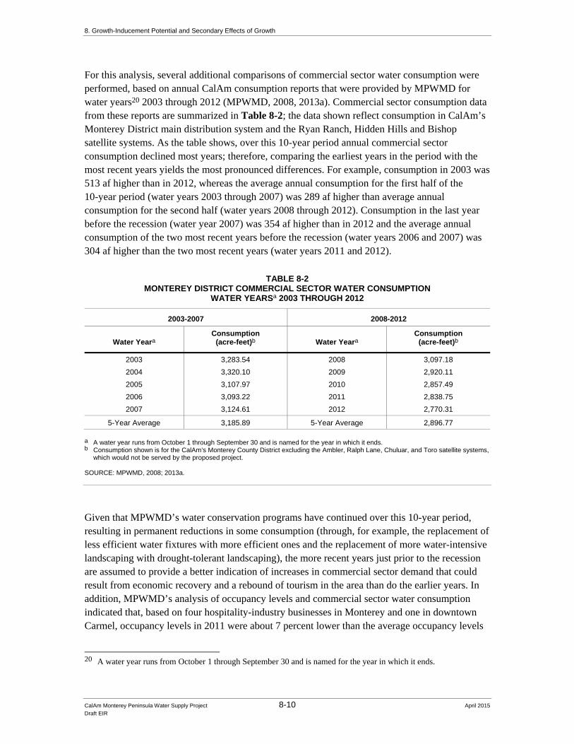
For this analysis, several additional comparisons of commercial sector water consumption were performed, based on annual CalAm consumption reports that were provided by MPWMD for water years20 2003 through 2012 (MPWMD, 2008, 2013a). Commercial sector consumption data from these reports are summarized in Table 8-2; the data shown reflect consumption in CalAm’s Monterey District main distribution system and the Ryan Ranch, Hidden Hills and Bishop satellite systems. As the table shows, over this 10-year period annual commercial sector consumption declined most years; therefore, comparing the earliest years in the period with the most recent years yields the most pronounced differences. For example, consumption in 2003 was 513 af higher than in 2012, whereas the average annual consumption for the first half of the 10-year period (water years 2003 through 2007) was 289 af higher than average annual consumption for the second half (water years 2008 through 2012). Consumption in the last year before the recession (water year 2007) was 354 af higher than in 2012 and the average annual consumption of the two most recent years before the recession (water years 2006 and 2007) was 304 af higher than the two most recent years (water years 2011 and 2012).
TABLE 8-2 MONTEREY DISTRICT COMMERCIAL SECTOR WATER CONSUMPTION
WATER YEARSa 2003 THROUGH 2012
2003-2007 2008-2012
Water Yeara Consumption
(acre-feet)b Water Yeara Consumption
(acre-feet)b
2003 3,283.54 2008 3,097.18
2004 3,320.10 2009 2,920.11
2005 3,107.97 2010 2,857.49
2006 3,093.22 2011 2,838.75
2007 3,124.61 2012 2,770.31
5-Year Average 3,185.89 5-Year Average 2,896.77 a A water year runs from October 1 through September 30 and is named for the year in which it ends. b Consumption shown is for the CalAm’s Monterey County District excluding the Ambler, Ralph Lane, Chuluar, and Toro satellite systems,
which would not be served by the proposed project. SOURCE: MPWMD, 2008; 2013a.
Given that MPWMD’s water conservation programs have continued over this 10-year period, resulting in permanent reductions in some consumption (through, for example, the replacement of less efficient water fixtures with more efficient ones and the replacement of more water-intensive landscaping with drought-tolerant landscaping), the more recent years just prior to the recession are assumed to provide a better indication of increases in commercial sector demand that could result from economic recovery and a rebound of tourism in the area than do the earlier years. In addition, MPWMD’s analysis of occupancy levels and commercial sector water consumption indicated that, based on four hospitality-industry businesses in Monterey and one in downtown Carmel, occupancy levels in 2011 were about 7 percent lower than the average occupancy levels
20 A water year runs from October 1 through September 30 and is named for the year in which it ends.

8. Growth-Inducement Potential and Secondary Effects of Growth
CalAm Monterey Peninsula Water Supply Project 8-11 April 2015 Draft EIR
for the years 1998 to 2001; based on this difference and commercial sector water consumption data, MPWMD calculated that a 7 percent increase in the average annual commercial water demand for years 2009 to 2011would increase annual demand by about 194 af. Therefore, increases in demand at area businesses from a rebounding economy and hospitality industry bounce-back may more likely be on the order of 200 or 300 afy than 500 afy.
The increases in demand discussed above are expected to occur due to increased occupancy rates without any expansion in capacity. Because no development or expansion of physical capacity would be involved in such demand increases, water supply provided to meet such increases would not be considered growth-inducing according to the CEQA provisions cited above.
To the extent businesses were expanded or new ones established to serve increased tourism in the area, such new development or expansion would only be possible if water supply were available. Water supply serving new or expanded businesses would remove water supply limitations as a constraint to such development and therefore would be growth-inducing according to CEQA. Based on the analysis above, a portion of 500 afy capacity proposed to meet demand for the existing hospitality industry may exceed the need for this purpose. This analysis assumes that excess water service capacity provided by the project would be available to support future growth and would therefore be considered growth inducing according to CEQA. According to the analysis above, from 200 to 300 afy (or about 250 afy) of the project capacity identified for hospitality bounce-back may be available to serve additional growth in the service area even with economic recovery.
Lots of Record
The proposed project would provide 1,181 afy of water to serve the development of legal lots of record in the service area. This estimate is apparently based on an estimate presented in CalAm’s 2006 UWMP, which cited a 2001 MPWMD estimate of demand associated with vacant buildable lots of record (CalAm, 2006).21 However, as described in Chapter 2, Water Demand, Supplies, and Water Rights, Section 2.3.2, the MPWMD no longer considers this a valid estimate. The most recent demand assessment prepared for MPWMD specifically on lots of record was a 2002 estimate that identified demand of 1,211 afy for lots of record in the incorporated cities of the service area; the District never adopted this estimate because it did not include demand associated with vacant lots on improved parcels in the unincorporated County areas. The MPWMD’s February 2013 testimony to the CPUC about the MPWSP concluded that CalAm’s estimate of 1,181 afy may underestimate demand associated with lots of record (Stoldt, 2013). MPWMD’s most recent estimate of future service area demand, prepared in collaboration with service area jurisdictions, was completed in 2006; it did not evaluate demand associated with lots of record per se, although it included demand associated with new residential and non-residential development under general plan buildout, which would include developable lots within the respective jurisdictions. Water supply that would serve currently vacant lots of record would
21 The 2006 UWMP refers to a 2001analysis by the MPWMD that “projected an additional California American
Water demand of 1,181 afy, based on a review of vacant legal buildable lots of record” (CalAm, 2006). Note that this is not CalAm’s currently adopted UWMP; CalAm’s current UWMP (WSC, 2012) does not include an estimate of demand associated with vacant lots of record.

8. Growth-Inducement Potential and Secondary Effects of Growth
CalAm Monterey Peninsula Water Supply Project 8-12 April 2015 Draft EIR
remove water supply limitations as an obstacle to the development of these lots and would be growth-inducing according to CEQA.
New demand can also be generated at developed lots of record (e.g., by the addition of bathrooms and fixtures) according to MPWMD’s methodology for calculating demand and its water permit system. Absent the addition of new dwelling units or similar intensification of use at a given lot, for purposes of this analysis, supply that would meet demand associated with remodels or fixture additions at developed lots would not be considered to be removing an obstacle to new development and therefore would not be growth-inducing. In any event, because the 1,181 afy could be used to support new development at currently vacant lots of record, based on MPWMD’s testimony and evidence, this analysis assumes it would be so used and that MPWSP supply used to serve this component of demand would be growth-inducing.
Assumptions Regarding Allocation and Use of MPWSP Water Service Capacity
MPWMD has not prepared an allocation program for water that would be provided by the MPWSP. As described in Chapter 2, Water Demand, Supplies, and Water Rights, Section 2.6.4, MPWMD has started the process of updating the EIR it prepared for its current allocation program and plans to initiate a process, separate from CalAm’s current application (A. 12-04-019) proceeding for the MPWSP, to address the allocation of water from the MPWSP in collaboration with service area jurisdictions and CalAm (CalAm et al., 2013). In the meantime, absent a new allocation for the MPWSP water, this analysis assumes that the MPWMD’s allocation of water provided by the project would be similar to the District’s current and past allocation programs. That is, for purposes of this EIR, it is assumed that supply provided by the proposed project would be allocated to meet existing demand within the CalAm service area and that water service capacity beyond that would be allocated to the jurisdictions in general proportion to an estimate (as yet undeveloped by MPWMD) of their future water supply needs. Once the water was allocated, each city and the County (for the unincorporated areas) would have the responsibility and discretion to approve or deny proposed development projects for which water was available, consistent with the jurisdiction’s role as the primary land use authority (discussed in Section 8.1.2.1 above) and applicable land use plans, policies, regulations and laws. For example, this analysis recognizes that supply based on an estimate of demand associated with lots of record may not be reserved exclusively to serve development of existing vacant lots; some portion of it could, for example, be used to support development of lots created subsequent to the preparation of this EIR or project approval, depending on the jurisdiction’s internal allocation system and assuming water service capacity was available.
This analysis also recognizes that the MPWMD could elect not to allocate to the County the approximately 325 afy proposed to serve Pebble Beach water entitlement-holders, in order to ensure that adequate water supply would be available when development associated with those entitlements was proposed. If, on the other hand, this portion of project water service capacity were allocated to the County, this analysis recognizes that the County could elect to allocate at least a portion of the 325 afy to other development – if, for example, other development was proposed first and/or the County determined that the entitlement-holders were unlikely to use the full amount. In either case, this portion of the proposed MPWSP supply would be used to serve new development.

8. Growth-Inducement Potential and Secondary Effects of Growth
CalAm Monterey Peninsula Water Supply Project 8-13 April 2015 Draft EIR
Similarly, because no mechanism is in place to reserve the 500 afy proposed to meet demand associated with hospitality industry bounce-back, this analysis assumes that the MPWMD, or jurisdictions receiving allocations related to this component of project capacity, could elect not to set aside 500 afy exclusively for use by existing businesses. Therefore, some portion of this 500 afy could in actuality be used to serve new development within the service area.
Conclusion: MPWSP Water Service Capacity
The MPWSP, in conjunction with existing and other planned water supply sources, would provide water supply totaling 15,296 afy. Of this, 13,291 afy would serve existing demand within the service area and the remaining 2,005 afy would be used to meet anticipated future demand. As discussed above, analysis of changes in demand before and since the recent recession indicate that rebound of the hospitality industry under improved economic conditions may not generate 500 afy of demand that the project proposes. Rather, hospitality industry bounce-back may increase commercial sector demand by 200 to 300 afy, which would leave the remaining 200 to 300 afy available for other uses. Therefore, this analysis assumes that about 250 afy of supply designated for hospitality industry bounce-back would likely be used for this purpose and 250 afy would be available for new development. Thus, 13,541 afy of the 15,296 afy supply would be used to meet existing demand and demand of existing business customers, and 1,755 afy would be available to support new development. New development would include, but would not necessarily be limited to, development of existing lots of record and development by Pebble Beach water entitlement holders.22 These estimates are summarized in Table 8-3. Water supply capacity to serve new development would remove water supply limitations as an obstacle to such development and would be growth-inducing according to CEQA.
TABLE 8-3 SUPPLY ASSUMPTIONS: WATER POTENTIALLY AVAILABLE FOR GROWTH
(acre-feet per year)
Demand Component Proposed Supply Supply for
Existing Land Uses Supply for
Future Development
Existing System Demand 13,291 13,291 -
Pebble Beach Water Entitlements 325 325
Hospitality Industry Bounce-Back 500 250a 250
Legal Lots of Record 1,180 1,180
Total 15,296 13,541 1,755 a A comparison of commercial sector demand prepared for this analysis suggests that demand by the hospitality industry under improved
economic conditions may be lower than identified by CalAm; refer to text discussion for more information.
SOURCE: Table 8-1.
22 Jurisdictions to which water has been allocated could also commit a portion of their supply to demand associated
with remodeling at existing residences, although this was not proposed and is not assumed in this analysis.

8. Growth-Inducement Potential and Secondary Effects of Growth
CalAm Monterey Peninsula Water Supply Project 8-14 April 2015 Draft EIR
8.2.2 MPWSP Infrastructure Capacity
8.2.2.1 Pipeline Capacity
CalAm sized the pipelines that would be constructed as part of the proposed project to accommodate a range of flow volumes, including flows associated with a 6.4 million gallons per day (mgd) desalination plant (the size of the plant if the plant was constructed in conjunction with the Groundwater Replenishment [GWR] Project, as part of the MPWSP Variant evaluated in Chapter 6 of this EIR) and the proposed 9.6-mgd MPWSP Desalination Plant. Consistent with standard engineering practice, pipeline sizing takes into account the need to meet peak demands, since water demand fluctuates daily, monthly and seasonally over the course of a year. (The analysis of peak month demand prepared for CalAm recommended a 9.6-mgd plant to meet anticipated peak month demands; refer to Chapter 2, Water Demand, Supplies, and Water Rights, Section 2.5, for more information regarding CalAm’s evaluation of peak month demands.) Table 8-4 shows the flow capacity of the proposed pipeline segments and the flows that would be generated by the 6.4- and 9.6-mgd plants. The table also shows that all but one pipeline would have the capacity to accommodate flows generated by a somewhat larger-capacity plant.
Added pumping pressure enables pipelines of a given size to accommodate the higher flows. For example, the estimated operating pressure needed to pump flows generated by a 9.6-mgd plant from the proposed MPWSP Desalination Plant to the proposed Terminal Reservoir is 132 pounds per square inch (psi). To pump an additional 1.6 mgd, i.e., the flows generated by the six modules of a 9.6-mgd plant plus its standby module (a total of 11.2 mgd) would require an operating pressure of 136 psi. The smaller 6.4-mgd plant that would be constructed under the MPWSP Variant would require an operating pressure of 128 psi to pump water the same distance, and an additional 2 psi (a total of 130 psi) to pump the flows generated by the four modules of the 6.4-mgd plant plus its standby module (a total of 8.0 mgd). While CalAm does not propose to operate all units including the standby module concurrently to meet normal demand conditions or for extended periods, it is common practice to be able to operate all units in the event of an emergency (Svindland 2014). Therefore, CalAm’s initial basis for pipeline sizing assumed seven 1.6-mgd modules operating concurrently for the 9.6-mgd plant and five 1.6-mgd modules operating concurrently for the 6.4-mgd plant. As Table 8-4 shows, except for the Transfer Pipeline, all the pipeline segments would have the capacity to accommodate somewhat higher flows than would be generated by a 9.6-mgd plant plus its standby module (i.e., there would be capacity to accommodate flows associated with a 12.8-mgd plant). CalAm has noted that the lower end of the range of flows would have lower overall energy requirements (e.g., if the smaller plant were constructed) and that the pipelines’ capacity to accommodate the higher end of the flows would delay the possible need for future, disruptive, pipeline expansion projects (Svindland, 2014).
Sizing the pipelines to accommodate flows beyond that needed to serve the proposed project would remove constrained pipeline capacity as an obstacle to future growth and therefore would have a growth inducing effect beyond the provision of water supply proposed to be provided by the MPWSP, discussed above. Additional water supply would be required to generate the higher future flows that could be accommodated by the MPWSP pipelines. Expansion of the desalination plant to increase its production capacity beyond that currently proposed would require additional

8. Growth-Inducement Potential and Secondary Effects of Growth
CalAm Monterey Peninsula Water Supply Project 8-15 April 2015 Draft EIR
TABLE 8-4 RANGE OF FLOW VOLUMES ACCOMMODATED BY PIPELINE SEGMENT
Pipeline Segment
Pipeline Capacity
(Flow Volumes Accommodated)
(mgd)
Flow per Pipeline
Segment for6.4 MGD Planta (mgd)
Flow per Pipeline
Segment for9.6 MGD Plantb (mgd)
Flow per Pipeline
Segment for 11.2 MGD
Plantc (mgd)
Flow per Pipeline
Segment for12.8 MGD
Plantd (mgd)
Source Water Pipeline 16-30 16 24 28 30
Brine Discharge Pipeline 12-20 10 14 17 18
Salinas Valley Return Pipeline 2-4 2 3 3 4
Desalinated Water Pipeline 6-13 6 10 11 13
Transmission Main 6-13 6 10 11 13
Monterey Pipeline 19-26 19 23 24 16
Transfer Pipeline 13 13 14 15 15
ASR Pipeline 15 15 15 15 15
a Flow that would be generated by four 1.6-mgd reverse osmosis modules; i.e., operation of the 6.4-mgd plant not including its 1.6-mgd
standby module. b Flow that would be generated by six 1.6-mgd reverse osmosis modules; i.e., operation of the 9.6-mgd plant not including its 1.6-mgd
standby module. c Flow that would be generated by seven 1.6-mgd reverse osmosis modules; i.e., concurrent operation of all six modules of a 9.6-mgd
plant and its 1.6-mgd standby module. d Flow that would be generated by eight 1.6-mgd reverse-osmosis modules. While this size plant is not proposed, this column shows that
all but one pipeline segment (Transfer Pipeline) would have capacity, with increased pumping pressure, to accommodate flows from a 12.8-mgd plant.
SOURCE: Svindland, 2014.
CEQA review and approval by the CPUC. In addition, increased production capacity would require discretionary permit approval, subject to CEQA review, by the MPWMD, pursuant to its Rule 22, and very likely other agency approvals.
According to the proposed Settlement Agreement between CalAm and other parties relating to CalAm’s application before the CPUC for approval of the MPWSP, MPWMD intends to initiate a collaborative process to work with the Monterey Peninsula Regional Water Authority, Monterey County, and CalAm to develop a process for determining an accurate estimate of added water supply capacity needed to meet the General Plan buildout projections for communities served by CalAm. However, that process has not been initiated and the results of such a process cannot be predicted and would be speculative at this time. Because the provision of additional future supply that could be accommodated, with additional pumping pressure, by the MPWSP pipelines has not been proposed, and would require additional CEQA review and other discretionary approvals if and when such additional supply were proposed, the prospect that the MPWSP pipelines would convey more supply than is currently proposed is considered speculative and not considered further in this analysis.

8. Growth-Inducement Potential and Secondary Effects of Growth
CalAm Monterey Peninsula Water Supply Project 8-16 April 2015 Draft EIR
8.2.2.2 Permitted Desalination Plant Capacity
CalAm has requested that permitted capacity for the project include a 9.6-mgd desalination plant even though a smaller plant would be adequate to meet demand if the project is implemented in conjunction with the GWR Project (i.e., if the MPWSP Variant were implemented). In advocating that the CPUC authorize a 9.6-mgd plant, CalAm has noted the urgency of pursuing financing and other required permits for the project in light of the California State Water Resources Control Board’s (SWRCB) Cease and Desist Order deadline. CalAm’s perspective is that, due to the impending deadline, the company cannot delay pursuing project financing and the other necessary permits until a final determination on the viability and feasibility of the GWR has been made, and that it would be easier for the company to construct a smaller plant than was permitted (if the GWR proves feasible) than pursue another round of permitting if a smaller (6.4-mgd) plant were authorized and the GWR were subsequently determined to be infeasible (Stephenson and Svindland, 2013).
The proposed project is either (1) a 9.6-mgd desalination plant or (2) a 6.4-mgd plant in conjunction with the GWR project. CalAm is not proposing nor would the CPUC approve a 9.6-mgd plant and the GWR water purchase. As outlined in the preliminary scope for Phase 2 of CPUC proceeding for the proposed project, the CPUC could approve a 9.6-mgd plant, while at the same time focusing on whether certain findings can be made regarding the viability of the GWR project; whether a smaller desalination plant can be authorized; and whether a water purchase agreement should be approved (CPUC, 2013). If the CPUC made such findings and determinations, then the smaller plant would be constructed in conjunction with a contract to purchase GWR water. Thus, the annual supply that would be provided by either the proposed MPWSP or the MPWSP Variant would (with other sources of supply) meet the estimated demand of 15,296 afy.
8.2.3 Growth Trends and Planning Agency Projections For context in considering the project’s growth-inducement potential, this section presents census data indicating recent growth trends in service area jurisdictions, the projections of future growth prepared by the regional planning agency, and growth trends anticipated in the general plans of service area jurisdictions.
8.2.3.1 Service Area Growth Trends 1990-2010
Population and housing data from the decennial U.S. census for the years 1990, 2000, and 2010 are shown in Table 8-5. As shown, except for Sand City, population in all service area cities declined between 1990 and 2000; population in service area cities as a whole decreased by about 9 percent. The decrease in population slowed between 2000 and 2010, decreasing by 3 percent for the cities as a whole. Sand City’s population increased in both decades, by 36 percent (69 new residents) between 1990 and 2000 and 28 percent (73 new residents) between 2000 and 2010. The total number of housing units in service area cities decreased slightly between 1990 and 2000 (by 0.6 percent) and increased slightly (by 1 percent) between 2000 and 2010. Information shown for the unincorporated county is for the entire county, not just the part in CalAm’s service area. Population in unincorporated Monterey County stayed about the same over these two decades, increasing by about 1 percent between 1990 and 2000 and decreasing by about 1 percent between 2000 and 2010, while the number of housing units increased.

8. Growth-Inducement Potential and Secondary Effects of Growth
CalAm Monterey Peninsula Water Supply Project 8-17 April 2015 Draft EIR
TABLE 8-5 SERVICE AREA GROWTH TRENDS 1990-2010
POPULATION AND HOUSING
Population Housing Units
Jurisdiction 1990
Census 2000
Census 2010
Census
Change 1990-2000
Percent Change 1990-2000
Change 2000-2010
Percent Change 2000-2010
1990 Census
2000 Census
2010 Census
Change 1990-2000
Percent Change 1990-2000
Change 2000-2010
Percent Change 2000-2010
Carmel 4,241 4,081 3,722 -160 -3.8% -359 -8.8% 3,325 3,334 3,417 9 0.3% 83 2.5%
Del Rey Oaks 1,661 1,650 1,624 -11 -0.7% -26 -1.6% 733 727 741 -6 -0.8% 14 1.9%
Monterey (city) 31,954 29,696 27,810 -2,258 -7.1% -1,886 -6.4% 13,497 13,383 13,584 -114 -0.8% 201 1.5%
Pacific Grove 16,117 15,522 15,041 -595 -3.7% -481 -3.1% 7,916 8,032 8,169 116 1.5% 137 1.7%
Sand City 192 261 334 69 35.9% 73 28% 86 87 145 1 1.2% 58 66.7%
Seaside 38,826 33,097 33,025 -5,729 -14.8% -72 -0.02% 11,214 11,005 10,872 -209 -1.9% -133 -1.2%
Subtotal: Cities 92,991 84,307 81,556 -8,684 -9.3% -2,751 -3.3% 36,771 36,568 36,928 -203 -0.6% 360 1.0%
Unincorporated Countya
100,461 101,414 100,213 953 0.9% -1,201 -1.2% 34,342 37,139 38,296 2,797 8.1% 1,157 3.1%
a Data are for the entire unincorporated county. SOURCE: California Department of Finance, 2007; 2013.

8. Growth-Inducement Potential and Secondary Effects of Growth
CalAm Monterey Peninsula Water Supply Project 8-18 April 2015 Draft EIR
8.2.3.2 AMBAG Projections
AMBAG’s current forecast of population, housing and employment was adopted in June 2014 in conjunction with AMBAG’s adoption of its Metropolitan Transportation Plan/Sustainable Communities Strategy for the region. Table 8-6 shows the growth forecast for cities in the CalAm service area and unincorporated Monterey County. Unlike AMBAG’s previous forecast, which was adopted in 2008, the current forecast takes into account the 2010 census, the Sustainable Communities Strategy requirements of SB 375, and the effects of the economic downturn that occurred between 2008 and 2012; development of the forecasts involved substantial input and feedback from the jurisdictions in the AMBAG region (AMBAG, 2014a). Although population, housing, and jobs in the service area cities as a whole and unincorporated Monterey County were lower in 2010 than had been projected in AMBAG’s 2008 forecast, the current forecast projects faster population and housing growth rates in service area cities over the 2010-2035 planning period compared to the previous forecast. Therefore, by 2035, the 2014 forecast projects more population and housing in service area cities overall by 2035 than had been projected in the previous forecast. As Table 8-6 shows, the population of each service area city is projected to increase over the 2010-2035 projection period, although Carmel is projected to lose population between 2010 and 2020, before beginning to grow again. In terms of percentage increase, Sand City is projected to grow the fastest, although because of its small size the net increase in Sand City population over the 25-year projection period is smaller than that of several other service area cities. Seaside is projected to have the largest net increase in population over the projection period. Overall, the population of service area cities is projected to increase by 21 percent between 2010 and 2035. Housing stock in the cities is projected to grow at a slower pace, increasing by 12 percent over the projection period. Employment in service area cities as a whole is projected to grow faster than population, with the number of jobs increasing by almost 30 percent by 2035. Projections shown in Table 8-6 for unincorporated Monterey County are for the entire unincorporated area, much of which is outside CalAm’s service area. Population in the unincorporated areas of the county is projected to grow by 4 percent over the projection period, while the number of housing units is projected to increase by 2 percent and jobs are projected to increase by 9 percent.
8.2.3.3 Growth Trends and Projections in Jurisdiction Planning Documents
As discussed in Section 8.2.1, the MPWSP would provide more water than needed to meet existing demand and demand associated with existing businesses; i.e., there would be water to serve additional development – water for growth. In evaluating the potential environmental effects of growth, a key consideration is whether the growth induced or supported by a project would be planned growth – i.e., growth that is anticipated in the adopted planning documents of the jurisdictions served by that project. The land use plans of the jurisdictions served by CalAm establish land use development patterns and growth policies that are intended to allow for the orderly expansion of urban development supported by adequate public services and infrastructure, and a project that would induce growth that was inconsistent with local land use plans and policies could result in adverse environmental impacts not previously addressed in the CEQA review of those adopted plans. Therefore, the general plans of jurisdictions that would be served by the MPWSP were reviewed.

8. Growth-Inducement Potential and Secondary Effects of Growth
CalAm Monterey Peninsula Water Supply Project 8-19 April 2015 Draft EIR
TABLE 8-6 AMBAG POPULATION, HOUSING, AND EMPLOYMENT PROJECTIONS
Jurisdiction 2010 2020 2025 2030 2035
Percent Change
2010–2035
POPULATION
Cities – CalAm Service Area Carmel 3,722 3,541 3,661 3,789 3,917 5%
Del Rey Oaks 1,624 1,889 2,345 2,806 3,468 114%
Monterey 27,810 28,004 28,839 29,743 30,647 10%
Pacific Grove 15,041 15,394 15,914 16,472 17,030 13%
Sand City 334 1,048 1,198 1,414 1,550 364%
Seaside 33,025 36,120 40,260 41,308 42,256 28%
Total - CalAm Cities 81,556 85,996 92,271 94,533 98,868 21%
Unincorporated Countya 100,213 102,847 103,147 104,028 104,304 4%
HOUSING UNITS 2010 2020 2025 2030 2035
Cities – CalAm Service Area Carmel 3, 417 3,417 3,417 3,417 3,418 0.0%
Del Rey Oaks 741 898 1,035 1,246 1,521 105%
Monterey 13,584 13,665 13,695 13,750 14,001 3%
Pacific Grove 8,169 8,169 8,169 8,274 8,478 4%
Sand City 145 439 496 586 629 334%
Seaside 11,335 12,556 12,907 13,311 13,664 21%
Total - CalAm Cities 37,391 39,144 39,719 40,584 41,711 12%
Unincorporated Countya 38,971 39,337 39,633 39,730 39,735 2%
EMPLOYMENT (JOBS)
Cities – CalAm Service Area Carmel 2,282 2,645 2,716 2,793 2,875 26%
Del Rey Oaks 414 640 602 592 573 38%
Monterey 26,934 31,249 32512 33,597 34,828 29%
Pacific Grove 8,792 10,161 10,499 10827 11,194 27%
Sand City 1,561 1,839 1,873 1,908 2,500 60%
Seaside 7,790 8,828 9,092 9,344 9,628 24%
Total - CalAm Cities 47,773 55,362 57,294 59,061 61,597 29%
Unincorporated Countya 58,071 62,998 63,795 63,955 63,443 9%
a Projections are for all unincorporated areas of Monterey County. SOURCE: AMBAG, 2014a.

8. Growth-Inducement Potential and Secondary Effects of Growth
CalAm Monterey Peninsula Water Supply Project 8-20 April 2015 Draft EIR
This section provides brief summaries on expected growth in service area jurisdictions contained in the jurisdictions’ general plans and related planning documents; the summaries include the jurisdictions’ housing need allocation identified through the Regional Housing Need Allocation (RHNA) process, since that represents potential residential growth planned for in the jurisdictions’ general plan housing elements. To the extent the general plans describe the jurisdiction’s approach to allocating its water supply (from the allocation administered by MPWMD), that information is noted.23 The summaries include estimates of current and projected population and housing to the extent this information is provided.
According to the general plans, most jurisdictions in the service area are largely built out (except for former Fort Ord lands that several cities have annexed24) and infill development and intensification of land uses is identified as a means of accommodating additional growth; all jurisdictions cite limited water supply as a key factor limiting planned development within the jurisdictions. Most of the general plans were adopted before the start of the economic recession that began in late 2007-early 2008 and therefore do not reflect or anticipate its effects; the general plan housing elements were adopted more recently, in 2010 and 2011.
City of Carmel-by-the-Sea
The City of Carmel-by-the-Sea’s General Plan was adopted in 2003 and the City of Carmel-by-the-Sea 2007-2014 Housing Element was updated and adopted in 2010 (City of Carmel, 2003, 2010a).
The Housing Element notes that the city’s population decreased between 1990 and 2000 and cites AMBAG’s 2008 forecast projecting that the population would continue to decrease, by about 6 percent between 2000 and 2015. (As shown in Table 8-5, census data indicate that the city’s population decreased by about 9 percent between 2000 and 2010.) The Housing Element, citing the AMBAG forecast, also states that Carmel is projected to add 24 new households (occupied housing units) between 2000 and 2015.
Noting that AMBAG’s Regional Housing Need Allocation for 2007-2014 identified a housing need in Carmel of 32 additional housing units,25 the Housing Element identifies the capacity to accommodate a total of 187 additional residential units.
The Housing Element identifies lack of water as the primary infrastructure constraint to the development of housing in Carmel, and states that the lack of an available water supply has limited growth in Carmel and throughout the Monterey Peninsula region over the last ten years. According to the General Plan, the City allocates its share of Monterey Peninsula water supply based on policies in the General Plan’s Land Use and Community Character and Housing Elements. Residential uses have high priority and the largest water allocation. Existing subdivided lots zoned for housing are considered “first in line” for limited water resources, except when this would preclude development of essential public services,
23 CalAm has not proposed how jurisdictions may allocate MPWSP water that is proposed to serve vacant lots of
record, e.g., nor does the MPWMD dictate how water it allocates to jurisdictions is managed. To the extent the general plans included information on how the jurisdiction currently allocates its water supply, such information may provide insight on how the jurisdiction would allocate its MPWSP supply.
24 The former Fort Ord lands are served by another water provider, Marina Coast Water District, not CalAm; therefore development planned for these lands is not a focus of this analysis.
25 AMBAG’s RHNA for the 2014-2023 period (AMBAG, 2014b), which the next version of jurisdictions’ Housing Elements will cover, identified a housing need in Carmel of 31 units.

8. Growth-Inducement Potential and Secondary Effects of Growth
CalAm Monterey Peninsula Water Supply Project 8-21 April 2015 Draft EIR
recreational uses/facilities, or visitor-serving uses consistent with the Coastal Act. The city limits new subdivisions of land until existing subdivided lots have a secure water supply, and endorses the concept of distributing the limited water resources across many properties as a means to prevent any single project from consuming a disproportionate share of available water and to maximize the number of units that can be built or approved.
According to the Housing Element the City is close to expending its water allocation from MPWMD: the City has about 3.251 af of available water, of which about 1.67 af are in the City’s reserves. The City supports efforts by the MPWMD and other agencies to expand the water supply and has a representative on both the MPWMD Technical Advisory Committee and the Policy Advisory Committee. The General Plan states that augmenting scarce water supplies to serve planned growth continues to be a City policy, that the City will support water projects that are financially and environmentally sound, and also that water projects and programs must not lead to unacceptable levels of rationing during droughts. The City's Municipal Code includes specific requirements for water conservation in existing and new developments. New development projects and existing structures needing a building permit for substantial proposed construction must meet the City's water conservation requirements.
City of Del Rey Oaks
The City of Del Rey Oaks General Plan was adopted in 1997 and has a planning period of approximately 20 years (City of Del Rey Oaks, 1997a). A draft update of the Housing Element was prepared in August 2006 but not adopted.
The General Plan estimates that the city had a population of 1,692 in 1996 and provided about 321 jobs in the City’s commercial and institutional sectors. (The 2010 census indicates the city had a population of 1,624 in 2010; AMBAG’s 2014 forecast estimates that the city had 414 jobs in 2010.)
Buildout under the General Plan of the part of the city served by CalAm (i.e., the area within the city limits prior to annexation of former Fort Ord land) would result in five additional residential units and development of 43,500 gross square feet of retail/commercial land uses and a 205-room hotel. General Plan policies call for expanded and new revenue-generating commercial/retail businesses on visitor-serving and commercially zoned parcels in the City, development of commercial and retail uses at the City’s Highway 68/218 entrance, intensification of existing development, and the annexation of former Fort Ord land to provide additional sites for economic development.
Buildout under the General Plan of the part of the city served by another water provider (i.e., the former Fort Ord land that was annexed to the city and is served by water provided via the Fort Ord Reuse Authority [FORA] and the Marina Coast Water District [MCWD]), includes development of a conference center, hotel, golf course, retail shops, a fitness center, office park, and corporate office center.
AMBAG’s Regional Housing Need Allocation for the 2007-2014 period identified a housing need in Del Rey Oaks of 150 additional housing units; as noted above, a draft Housing Element was prepared in 2006 but not adopted.26
26 AMBAG’s RHNA for the 2014-2023 period (AMBAG, 2014b), which the next version of jurisdictions’ Housing
Elements will cover, identified a housing need in Del Rey Oaks of 27 units; the 2007-2014 RHNA does not explain the relatively high number of units allocated to Del Rey Oaks for that period.

8. Growth-Inducement Potential and Secondary Effects of Growth
CalAm Monterey Peninsula Water Supply Project 8-22 April 2015 Draft EIR
The General Plan indicates that the City had about 5.807 af of water for new land uses remaining in its allocation from MPWMD as of June 1995. (According to MPWMD’s November 2013 monthly allocation report, Del Rey Oaks has no water remaining in its allocation [MPMWD, 2013b]).
The General Plan identifies water as a paramount concern for all of the jurisdictions on the Monterey Peninsula and states that setbacks in providing additional supply and SWCRB’s requirement that CalAm decrease withdrawals from the Carmel River have magnified concern about the availability of water to support growth. General Plan policies call for the City to: develop a water allocation program to prioritize water connections; work with the appropriate water management districts to encourage water conservation, retrofitting, education, reclamation, and reuse; consider water usage and conservation in all land use decisions; adopt and enforce a water conservation ordinance; and condition development plan approval on verification of available water service for projects.
City of Monterey
The City of Monterey General Plan was adopted in 2005 and includes amendments through November 2010; the City of Monterey Housing Element 2009-2014 was adopted in 2009 (City of Monterey, 2010, 2009).
According to the General Plan EIR, the City’s population under buildout is projected to increase by 4,189, a 14 percent increase from the estimated population at the time of 30,350. (As shown in Table 8-5, the 2010 census indicates the city’s population that year was 27,810.)
According to the Housing Element, most residential development is expected to occur from the intensification of land use within existing mixed-use commercial neighborhoods and infill of existing vacant parcels in areas designated for multi-family or single-family residential use throughout the City. The 20-year residential development capacity under the General Plan is estimated to be 2,135 additional units. The only new vacant land is 138 acres of former Fort Ord land that was recently annexed to the City; of this 113 acres will be for industrial use and 25 acres for parks, recreation and open space uses. (Water for the Fort Ord annexation area is provided via the FORA and MCWD, not CalAm.) No substantial changes in commercial and/or industrial development potential in the City are anticipated except for the industrial development potential in the Fort Ord annexation area.
AMBAG’s Regional Housing Need Allocation for 2007-2014 identified a housing need in Monterey of 657 additional units.27 The City of Monterey 2009-2014 Housing Element identifies the realistic potential to construct a total of 2,008 residential units over the housing allocation period.
The lack of available water is a primary obstacle to meeting General Plan goals; therefore, it is the goal of the City of Monterey and the General Plan to obtain a long-term, sustainable water supply, including evaluation of water supply options outside the present MPWMD framework. The City’s internal allocation system established allotments for residential, commercial, and industrial uses, and maintained part of the total allocation as a citywide reserve. No water is currently available for commercial or residential development; applicants for new commercial and residential projects or other projects are placed on a water waiting list. As of November 2003, the City’s reserve of 6.050 af had
27 AMBAG’s RHNA for the 2014-2023 period (AMBAG, 2014b), which the next version of jurisdictions’ Housing
Elements will cover, identified a housing need in Monterey of 650units.

8. Growth-Inducement Potential and Secondary Effects of Growth
CalAm Monterey Peninsula Water Supply Project 8-23 April 2015 Draft EIR
been conditionally reserved for several public and private projects; the entire allocation to the City is thus either being used or has been reserved for identified uses (City of Monterey, 2010, 2004). New residential and commercial development under the General Plan would increase demand for water managed by the MPWMD and supplied by CalAm (City of Monterey, 2004).
Presidio of Monterey The Presidio of Monterey (Presidio) is an active installation of the U.S. Department of the
Army (U.S. Army); while located within the Monterey city limits, it is not governed by the City. Water used at the Presidio is part of MPWMD’s overall allocation to the City. In 2013 the Army completed an Environmental Impact Statement (EIS) for the Presidio’s Real Property Master Plan (RPMP) (U.S. Army, 2013a, 2013b), which replaces the 1983 Presidio of Monterey Master Plan.
The RPMP identifies proposed short-range and long-range project building renovations or upgrades to be implemented over a 20-year planning horizon. The short-range project consists of Phase I of a multi-phase barracks complex project at the Presidio. The long range projects include access control point upgrades; classroom renovations; and demolition and construction of three barracks complex projects and several instructional buildings. The EIS evaluated the environmental consequences of the short range project at a project level of detail and the long range projects were evaluated at a programmatic level. Additional environmental review pursuant to the National Environmental Policy Act (NEPA) will be required for the long-range projects as they move forward.
The RPMP alternative selected for implementation locates most RPMP improvements within the Presidio, with some support facilities at the Ord Military Community site in the former Fort Ord military base. The EIS and Record of Decision for the EIS (U.S. Army, 2013a, 2013b) conclude that over the 20-year planning horizon for the RPMP, the long range projects would increase water demand at the Presidio by an estimated 34 afy. Water for the short range project would be provided through the Presidio’s existing permit. To meet demand for the long range projects, the EIS identifies a total of 36.9 afy from water currently used at outdated barracks that are scheduled to be demolished as part of the long range projects and water credits the Presidio has from the MPWMD. While concluding that the project would therefore have a less than significant impact with respect to water supply, the EIS notes that future developments concerning the Cease and Desist Order and the March 2011 moratorium on water service connections could affect water supply in the Monterey Region and identifies mitigation measures to reduce future water demand. Measures include additional water conservation measures, implementation of best management practices at all new facilities, and installing rainwater collection systems and purple piping (in anticipation of the availability of future recycled water supply) in all new buildings. The EIS states that the Army could also consider additional measures to ensure long term water supply at the Presidio and Ord Military Community, including the possible transfer or trade of a portion of the Ord Military Community’s water rights and contracting with current water providers for additional water in conjunction with the development of future regional water supply projects.
City of Pacific Grove
The City of Pacific Grove General Plan was adopted in 1994 and the City of Pacific GroveHousing Element 2007-2014 was adopted in 2011(City of Pacific Grove, 1994, 2011).

8. Growth-Inducement Potential and Secondary Effects of Growth
CalAm Monterey Peninsula Water Supply Project 8-24 April 2015 Draft EIR
The Housing Element describes the minimal population change that the city has experienced over the past 30 years, and states that, based on the California Department of Finance’s estimate of housing units for 2010, fewer than 200 housing units were added between 1990 and 2010. (The 2010 U.S. Census indicates that about 250 housing units were added over this 20 year period.) The City is almost fully built-out, with very little vacant buildable land. By the 1980s it was recognized that further growth in Pacific Grove would occur only as infill development on vacant lots and intensification of existing development.28 The City’s estimate of development potential, prepared in 1994, indicated that a maximum of 5,431 additional residential units could be built within the city limits. Most units would be accommodated through the intensification of existing development, including almost 3,500 secondary units attached to existing single family homes; vacant lots were projected to accommodate a total of 105 new single-family or multi-family units. Notwithstanding this estimate of maximum development potential, the General Plan noted that in the 10 years preceding its publication, only 42 secondary units had beenconstructed and that this rate of development suggested that, apart from water supply constraints, new secondary units would be added slowly and would not number in the thousands. Past trends suggested that the other identified residential capacity also would be developed slowly. The General Plan projected that an estimated 270,000 square feet of commercial development could be accommodated on commercially-zoned vacant parcels and more than 1 million square feet of commercial development could theoretically be added through intensification of existing uses.
AMBAG’s Regional Housing Need Allocation for 2007-2014 identified a housing need in Pacific Grove of 120 additional housing units.29 The City’s 2011 Housing Element identified a realistic potential for 197 new units to be constructed on vacant parcels and a maximum potential for 783 new units to be constructed on underutilized or redevelopment opportunity sites.
The Housing Element identifies the lack of available water as the greatest constraint on the production of new housing in Pacific Grove, stating that lack of water supply has resulted in very little new housing construction for over a decade. The City is working on projects to reduce the use of potable water where feasible, such as at the city’s golf course and cemetery. Housing Element policies call for continuing to work aggressively with MPWMD and other Monterey Peninsula cities to find long-term solutions to the water problem, to increase the water available for residential uses and provide for drought protection. At the time the 1994 General Plan was prepared the City had less than 8 af remaining of its water allocation. The 2011 Housing Element indicates that in 2008 the City Council distributed most of the 5 af that were then remaining, which enabled construction of more than 50 residential and non-residential projects; as of March 2011 the City had 0.595 af remaining of its allocation and had established a new water wait list. The Housing Element states that without a new water allocation, the City will be unable to permit any new housing construction except for the few properties that have sufficient onsite water credits for second units.
The 2011 Housing Element notes that although additional water supply needed to meet demand associated with buildout of the 1994 General Plan was previously estimated to be 1,264 afy, this estimate was based in part on the maximum potential for second units and that long-term demand is now expected to be less. In fact, in testimony provided to the
28 The General Plan did not contemplate the City annexing any unincorporated land except for a three-acre parcel (the
Mission Linen parcel) on unincorporated county land entirely surrounded by city lands. 29 AMBAG’s RHNA for the 2014-2023 period (AMBAG, 2014b), which the next version of jurisdictions’ Housing
Elements will cover, identified a housing need in Pacific Grove of 115 units.
8. Growth-Inducement Potential and Secondary Effects of Growth
CalAm Monterey Peninsula Water Supply Project 8-25 April 2015 Draft EIR
CPUC on the MPWSP, a City representative revised the future demand estimate the City had provided MPMWD in 2006, from 1,264 afy to 500 afy (as shown in Table 2-5 of Chapter 2).
Sand City
The Sand City General Plan: 2002-2017 was adopted in 2002 and the City of Sand City Housing Element Update 2009-2014 was adopted in 2010 (City of Sand City, 2002, 2010).
Describing the city’s historic growth rates, the General Plan states that the city’s population reached 600 in the 1960s, but subsequently declined as industrial and commercial land uses displaced residences. Between 1970 and 2000, the city’s population fluctuated somewhat, ranging from a low of 182 in 1980 to a high of 261 in 2000. (As shown in Table 8-5, the city continued to grow over the past decade, to a population of 334 in 2010.) Due to the city’s commercial and industrial land uses, its daytime population of employees and shoppers increases to almost 10,000) (LAFCO of Monterey County, 2011).
The 2002 General Plan projects a buildout population of 1,295 and points out that this city-generated estimate is lower than the population of approximately 1,800 that had been forecasted in AMBAG ‘s then-current 1997 forecast; AMBAG’s forecast, in turn, had been based in part on the city’s 1984 General Plan. The 2010 Housing Element cites AMBAG’s 2008 forecast projecting that the city’s population would grow dramatically between 2010 and 2015 (from 447 to 1,498) and would not change further between 2015 and 2035; the Housing Element confirms that population growth beyond what AMBAG had projected for 2015 was unlikely due to the city’s small size. (As shown in Table 8-6, AMBAG’s most recent forecast also projects substantial growth for the city, especially between 2010 and 2020, and now projects that the city will reach the earlier population estimate of about 1,500 residents between 2030 and 2035.) The 2002 General Plan reflects and focuses on achieving a vision for the community that includes economic diversification, active redevelopment, enhanced community appearance and image, organized and well-planned growth, elimination of land use conflicts, and cohesive residential neighborhoods.
AMBAG’s Regional Housing Need Allocation for 2007-2014 identified a housing need in Sand City of 120 additional units.30 According to the City’s 2010 Housing Element, 31 units had been constructed between January 2007 and February 2009 and an inventory of vacant and underutilized sites identified the capacity to accommodate a total of 277 additional units on vacant or underutilized sites. The City expects that 60 additional units will be produced in the city by the end of 2014 (City of Sand City, 2010).
The General Plan states that the critical shortage of water on the Monterey Peninsula limits the availability of water for new development and that this condition is expected to continue until either a long-term source of water is developed for the region or the City of Sand City develops a desalination facility as its own water supply. As of 2001, Sand City had allocated essentially all of its available water to specific development parcels. (Since the General Plan was prepared Sand City completed construction of a 300 afy desalination plant, which is operated by CalAm. While water from the desalination plant is delivered to the CalAm system, Sand City is entitled to 206 afy to support its future development: MPWMD Ordinance 132, in consideration for the delivery of 300 afy of potable water from this plant to the CalAm system, establishes a water entitlement of 206 afy from the CalAm system for
30 AMBAG’s RHNA for the 2014-2023 period (AMBAG, 2014b), which the next version of jurisdictions’ Housing
Elements will cover, identified a housing need in Sand City of 55 units.

8. Growth-Inducement Potential and Secondary Effects of Growth
CalAm Monterey Peninsula Water Supply Project 8-26 April 2015 Draft EIR
Sand City, separate from the city’s current water allocation; the ordinance indicates that the remaining 94 afy is permanently added to the broader CalAm’s system.)
Seaside
The Seaside General Plan was adopted in 2004 and the current General Plan Housing Element was adopted in 2011 (City of Seaside, 2004a, 2011a).
According to the General Plan, the city will have a total of about 12,300 dwelling units, 19,800 square feet of non-residential development, and a population of about 43,000 at buildout of the General Plan, assuming average levels of development allowed under the plan. While the estimate presented in the General Plan does not indicate how much of this overall development is existing development and how much represents expected future growth, a comparison of the buildout estimates for housing and population with 2010 census data for Seaside indicates that under General Plan buildout the city expects to add almost 1,500 new housing units and 10,000 new residents. The General Plan identifies the need for more employment opportunities and tax-generating land uses to improve the overall quality of life and includes policies to encourage regional commercial and visitor-serving commercial development, community-serving retail development, fuller use of underutilized properties, development that helps increase the City’s ratio of jobs to housing, and provision of a variety of housing types that complement employment opportunities in the community.
AMBAG’s Regional Housing Need Allocation for 2007-2014 identified a housing need in Seaside of 589 additional units.31 The City’s 2010 Housing Element identifies the City’s capacity to accommodate 1,113 additional units on vacant and underutilized residential and mixed use properties.
The Housing Element states that lack of adequate water supply is one of the three primary environmental constraints to the development of housing in Seaside; the other constraints are environmental hazards on former Fort Ord lands and significant biological resources in the eastern portion of the city. General Plan policies call for working cooperatively with regional and local water providers to ensure that adequate water supply is available to meet the needs of existing development and future growth; encouraging the production and use of recycled water; protecting and enhancing local and regional groundwater and surface water resources; eliminating long-term groundwater overdraft as soon as feasible; and reviewing development proposals to ensure that adequate water supply, treatment, and distribution capacity is available to meet the needs of the proposed development.
For the part of the city served by CalAm (the area that had been within the City boundaries prior to the City’s annexation of former Fort Ord lands to the north and east),32 the portion of MPWMD’s allocation that the City’s had allotted for residential use has been exhausted and the City has established a waiting list pending the allocation of future supply. Part of the allocation the City had reserved for economic development in mixed use projects is still
31 AMBAG’s RHNA for the 2014-2023 period (AMBAG, 2014b), which the next version of jurisdictions’ Housing
Elements will cover, identified a housing need in Seaside of 393units. 32 The part of the city that had been within the city limits prior to the annexation of former Fort Ord lands, which is
also the part of the city within the jurisdiction of the MPWMD, is variously referred to in the general plan as the southwestern portion of the city, southwest Seaside, the central core of the city, and Seaside proper. Part of this central core of the city is also served by the City-operated Seaside Municipal System, which operates three groundwater wells that serve the Del Monte Heights neighborhood.

8. Growth-Inducement Potential and Secondary Effects of Growth
CalAm Monterey Peninsula Water Supply Project 8-27 April 2015 Draft EIR
available. (Water for former Fort Ord lands annexed to the city is provided via the FORA and MCWD, not CalAm.33)
Monterey County
Note: The facts and figures presented in this section pertain to the County as a whole (or the unincorporated County as a whole, as noted), while CalAm does not serve the whole County.
The 2010 Monterey County General Plan (Monterey County, 2010a) was adopted in October 2010 and the County of Monterey Housing Element 2009-2014 (Monterey County, 2010b) was adopted in June 2010. The General Plan has a 2030 planning horizon, while the EIR prepared for the General Plan (Monterey County, 2010c, 2010d) considers conditions under the plan in 2030 and under plan buildout, which is estimated to occur in 2092.
The County’s population increased from 247,450 in 1970 to an estimated population of 428,550 in 2008. The decade with the fastest growth over this period was 1980-1990, during which the population increased by 22 percent. Data from the 2010 census, which were not available when the General Plan and its EIR were prepared, indicate that the County’s population was 415,057 in 2010, somewhat lower than the 2008 estimate included in the General Plan; the 2010 population represents a 3 percent increase since 2000. The proportion of the county’s population living in unincorporated areas has gradually decreased, from 29 percent in 1980 to 25 percent in 2000. According to the 2010 census, 24 percent of the County’s population lived in unincorporated areas that year.
Growth assumptions for the General Plan’s 2030 planning horizon are based on AMBAG’s 2004 population growth forecast, which projected that the county would grow from an estimated population of 464,847 in 2010 to 602,731 in 2030 (a 30 percent increase). AMBAG projected that the population in unincorporated county areas would grow from 105,485 in 201034 to 135,375 in 2030, a 28 percent increase. The General Plan EIR notes that in allocating the projected growth within the County, AMBAG considered growth trends and the availability of water among other factors; consequently, the Monterey Peninsula was projected to accommodate much lower levels of growth than the Salinas Valley, due to the peninsula’s greater water constraints.
AMBAG’s Regional Housing Need Allocation for 2007-2014 identified a housing need for unincorporated Monterey County of 1,554 additional housing units.35 The County Housing Element indicates that 490 units had been constructed between 2007 and July 2009, and that another 2,891 units had been approved or were in development since 2007. (Because those units did not completely meet the RHNA targets for affordable units, however, the County conducted an inventory of available sites; the inventory identified more than enough capacity to meet most of the targets for affordable housing but fell short (by 20 units) of meeting the identified need for housing affordable to moderate-income residents. To address this shortfall the County was exploring the possibility of purchasing several parcels that offered the greatest potential for developing additional affordable units.)
33 Seaside was allocated 748 af of the FORA’s total supply to serve the Fort Ord annexation lands in North Seaside.
The City does not expect this allocation to be increased in the near future, and the General Plan identifies the use of recycled water for golf courses and other non-potable uses in North Seaside as the best option for expanding the availability of the North Seaside allocation for economic development and residential uses.
34 As previously noted, the 2010 census data indicate that the County had not grown as much by 2010 as the 2004 forecast anticipated; according to the census the population of the unincorporated county in 2010 was 100,213.
35 AMBAG’s RHNA for the 2014-2023 period (AMBAG, 2014b), which the next version of jurisdictions’ Housing Elements will cover, identified a housing need in unincorporated Monterey County of 1,550 units.

8. Growth-Inducement Potential and Secondary Effects of Growth
CalAm Monterey Peninsula Water Supply Project 8-28 April 2015 Draft EIR
According to the General Plan EIR, implementation of the plan was expected to increase water demand over the planning period. At the time, although CalAm’s previously proposed desalination plant (under the Coastal Water Project) was expected to meet then-current demand on the Monterey Peninsula, the General Plan EIR anticipated that new or expanded water supply facilities and new or expanded water entitlements would be needed to meet future demand on the peninsula. General Plan polices addressing water supply include prohibiting new development that will use water and for which a discretionary permit is required unless there is proof that a long-term, sustainable water supply is available to serve the development; and denying approval of tentative subdivision maps until the applicant provides evidence of a long-term sustainable water supply for all lots to be created. To ensure the accuracy and consistency of water supply evaluations, another policy requires the Monterey County Health Department, in coordination with the MCWRA, to develop guidelines and procedures for conducting water supply assessments and determining water availability. Other policies call for the County to coordinate and collaborate with all agencies responsible for the management of existing and new water resources. As mitigation the General Plan EIR added a General Policy stating that the County will participate in regional coalitions for the purpose of identifying and supporting a variety of new water supply projects, water management programs, and multiple agency agreements that will provide additional domestic water supplies for the Monterey Peninsula and Seaside basin. According to this new policy the County’s general objective, while recognizing that timeframes will be dependent upon the dynamics of the regional group, is to complete the cooperative planning of these water supply alternatives within five years of adoption of the General Plan and to implement the selected alternatives within five years after that time. Other General Plan policies encourage the use of gray water and cisterns for commercial and multi-family residential landscaping; the use of recycled water as a potable water offset; and the establishment of ordinances that identify conservation measures to reduce demand for agricultural water and potable water.
The Greater Monterey Peninsula Area Plan includes a policy to encourage development projects to be served by water from public utilities or mutual water companies, and if this is not possible, for the County to consider the cumulative effects of the development's water use on wildlife, fish, and plant communities, and the supply available to existing users.
The Carmel Valley Master Plan includes policies requiring that pumping from the Carmel River aquifer be managed consistent with the Carmel River Management Program and that all beneficial uses of the total water resources of the Carmel River and its tributaries be considered in planning decisions; other policies support water projects designed to address future growth in the Carmel Valley and encourage the establishment of regulations to limit development in Carmel Valley to vacant lots of record and already-approved projects, unless additional water supplies are identified.
Monterey Peninsula Airport District
The Monterey Peninsula Airport District (Airport District) is currently developing a new master plan, a process that is expected to take two years. Until a new master plan is adopted, the Airport District’s 1992 Monterey Peninsula Airport Master Plan Update Final Report (Master Plan) (Monterey Peninsula Airport District, 1992) is considered the applicable land use planning document for airport development activities (Johnston, 2013).
The goals of the 1992 Master Plan are to address airport requirements over a 20-year planning period; 2010 is cited as the horizon year for specific aspects of the plan including projected airport activity and facility requirements. Based on anticipated changes in the fleet mix and projected growth in the number of passengers, annual operations (take-offs

8. Growth-Inducement Potential and Secondary Effects of Growth
CalAm Monterey Peninsula Water Supply Project 8-29 April 2015 Draft EIR
and landings), and general aviation use at the airport, the Master Plan was intended to meet the identified need for additional terminal areas, general aviation hangars, and aviation fuel storage, an expanded fire station, a larger maintenance building, and vehicle access improvements. The Master Plan includes three concepts each for the terminal area, the west end of the airport, and the northside of the airport, and recommends adoption of one of them (“Concept C”) for each of the three components. Each of the concepts would increase the area for the terminal ramp, the size of the terminal building, vehicle parking capacity, the number of hangars, and space available for fixed-base operators, other tenants, and airport support facilities.
Master Plan Appendix B, Utilities Inventory and Pavement Plan, includes a review of water service to the airport. The review states that past cases before the CPUC that concerned the adequacy of the water supply system for the Monterey Peninsula may restrict CalAm from serving new territory until additional supplies are assured or additional impounding reservoirs constructed. The discussion concludes, however, that the airport lies completely within the water company’s existing service area, that service to the airport property is long-standing, that airport water use is not excessive, and that curtailment of water for use by the Airport is not expected.
In a discussion of past studies related to the airport, the Master Plan states that the environmental document for the 1983 Airport and Runway Development Program concluded that development of the northside industrial area would require water service that was not currently allocated to the Airport District and that the District would need to work with MPWMD to resolve the issue to the extent possible; the Master Plan also discusses a 1987 EIR for the Comprehensive Land Use Plan for the Monterey Peninsula Airport which identified water resources as an area of controversy (Monterey Peninsula Airport District, 1992).
8.2.3.4 Comparison of Proposed Water Supply Capacity with MPWMD Estimate of Future Supply Needs
The project supply components that would provide water for future development (e.g. water for lots of record and Pebble Beach water entitlements) are not directly comparable to levels of growth planned for and described in jurisdictions’ general plans. To relate the portion of MPWSP supply that would support future development to the growth anticipated in jurisdictions’ adopted general plans, the MPWSP supply is compared with the estimate of future water supply needs that the MPWMD prepared in 2006 (MPWMD, 2006).36
The 2006 MPWMD estimate was a comprehensive assessment of long term water needs of customers in CalAm’s Monterey District main distribution system based on information obtained from service area jurisdictions; it included demand associated with expected remodels within the jurisdictions and anticipated development of single-family and multi-family residences, secondary units, and non-residential development expected to occur under buildout of each jurisdiction’s general plan. The MPWMD translated the growth estimate provided by the
36 As noted in Section 2.6.3 of Chapter 2, Water Demand, Supplies, and Water Rights, the MPWMD plans to initiate a
process, in collaboration with service area jurisdictions and CalAm, to evaluate the added water supply capacity needed to meet general plan buildout projections. Given that this new MPWMD process has not yet started and that most of the general plans considered in the 2006 evaluation are still in effect, this EIR uses the 2006 MPWMD analysis, adjusted as noted be below, as the basis for comparison.

8. Growth-Inducement Potential and Secondary Effects of Growth
CalAm Monterey Peninsula Water Supply Project 8-30 April 2015 Draft EIR
jurisdictions into water demand using water use factors for different land use categories. The estimate also included repayment of any water credits owed to property owners for implementing water-saving retrofits and a 20 percent contingency to address unforeseen water requirements. Based on this assessment, the estimated future needs to support growth anticipated in the general plans of the jurisdictions in the CalAm service area totaled 4,545 afy.37 The 2009 EIR prepared for CalAm’s proposed Coastal Water Project included a detailed evaluation of the consistency of the growth assumptions underlying MPWMD’s 2006 demand estimate with growth anticipated in the jurisdictions’ general plans and confirmed that overall the MPWMD’s estimate of future demand was consistent with growth under the general plans.38 That analysis is included in Appendix I1 for reference.
Since the 2006 estimate was prepared, the future water needs of three jurisdictions have been revised, reducing the total estimate of future water need from 4,545 to 3,446 afy. The new Monterey County General Plan, adopted in 2010, is the basis for one of the revisions; the City of Pacific Grove provided another revision, reducing its original 2006 estimate of future demand in testimony that the City provided regarding the MPWSP; and the water entitlement that Sand City has from construction of its 300-afy desalination plant would cover roughly half of Sand City’s 2006 estimated future demand. (Refer to the discussion of general plan buildout in Chapter 2, Water Demand, Supplies, and Water Rights, Section 2.6.2, for more information on the revised estimates.)
California Water Code Section 10608 requires water suppliers to reduce per capita water consumption 20 percent by 2020. The 20 percent reduction is to be achieved relative to baseline demand calculated pursuant to Department of Water Resources guidelines. According to CalAm’s 2010 UWMP, current per capita consumption in CalAm’s Monterey District is already below its 20 percent reduction target. Nevertheless, conservatively assuming that the Water Code 20 percent reduction target could apply to the water use assumptions MPWMD used in its 2006 estimate, the revised estimate of future water need discussed above, reduced by an additional 20 percent, would be 2,773 afy. As discussed above in Section 8.2.1.1, the portion of the water supply provided by the MPWSP that would be available for future development totals about 1,755 afy. This amount represents 63 percent of 2,773 afy, the 2006 estimate of future demand as revised based on updated information and reduced by an additional 20 percent; these estimates are summarized in Table 8-7. The 1,755 afy of MPWSP supply that would be available for future development represents about half (51 percent) of 3,446 afy, the 2006 estimate of future demand as revised based on updated information without the additional 20 percent reduction. Thus, to summarize, the portion of the water supply provided by the MPWSP beyond that needed to meet
37 Because the jurisdictions’ general plans were prepared in different years and covered different planning periods,
MPWMD did not characterize its estimate of future demand as accommodating growth over a given period of time or to a given year. The estimate was intended, however, to accommodate growth reasonably expected by each jurisdiction consistent with its adopted general plan.
38 The analysis found that with a few exceptions the estimates of residential growth were consistent with estimates contained in the general plans or general plan housing elements. Estimates of non-residential development were more difficult to compare because of substantial differences in the levels of detail in information submitted by jurisdictions to the MPWMD compared with information included in the general plans; to the extent the development potential could be compared the estimates were determined to be consistent.

8. Growth-Inducement Potential and Secondary Effects of Growth
CalAm Monterey Peninsula Water Supply Project 8-31 April 2015 Draft EIR
TABLE 8-7 FUTURE WATER DEMAND AND PROPOSED SUPPLY
(acre-feet per year)
Future Supply Needs (2006
Estimate)
Future Supply Needs
(Revised)a
Future Supply Needs
(Revised and Reduced by
20%)b
MPWSP Supply for
Future Development
MPWSP Supply as % of Future Supply Needs
(Revised)
MPWSP Supply as % of FutureSupply Needs (Revised and
Reduced)
Jurisdiction Total 4,545 3,446 2,773 1,755 51% 63%
a Future supply needs revised based on changes in future demand estimates in three service area jurisdictions (discussed in more detail in Section 2.6.3 of Chapter 2).
b Estimated future supply needs reduced by an additional 20 percent based on the conservative assumption that water reduction requirements of Water Code Section 10608 may apply. CalAm’s Monterey District 2010 UWMP indicates that the service area has already met the 20 percent reduction target.
SOURCES: Table 2-8, Table 8-3.
existing demand and demand of existing business customers – the portion of supply that would therefore be available to support future development – would supply 51 to 63 percent of the water demand associated with planned growth estimated by MPWMD in 2006, in collaboration with service area jurisdictions, as adjusted to reflect the updated information summarized above.
Given that the 2006 estimate of future water needs was generally consistent with the level of growth planned for in the adopted general plans of service area jurisdictions, the smaller MPWSP supply that would be available to support future development would similarly be consistent with the service area’s planned growth.
8.3 Impacts and Mitigation Measures: Secondary Effects of Growth
Impact 8-1: Secondary effects of planned growth.
The MPWSP would support a degree of planned growth in the jurisdictions served by the proposed project. In general, development planned and approved through the general plan process in the CalAm service area would have environmental impacts. The environmental consequences of this planned growth have been largely addressed in local plans and the associated CEQA review as well as in other, project-specific documentation. Some of the identified indirect effects of growth are significant and unavoidable; others are significant but can be mitigated.
Although most of the general plan EIRs reviewed for this EIR were prepared prior to the passage of the California Global Warming Solutions Act of 2006 and do not include assessments of impacts of greenhouse gas emissions, it is expected that planned growth in the area could result in significant and unavoidable contribution to increases in greenhouse gas emissions (e.g., from increased fossil fuel use for transportation and construction, increased industrial and commercial activities, residential energy use, operation of power plants, and oil refining).

8. Growth-Inducement Potential and Secondary Effects of Growth
CalAm Monterey Peninsula Water Supply Project 8-32 April 2015 Draft EIR
The following environmental documents for city and county general plans and general plan elements were reviewed in order to identify the significant impacts associated with planned growth in the area:
City of Carmel-by-the-Sea, 2010b. City of Carmel-by-the-Sea 2007-2014 Housing Element Public Review Draft Initial Study / Mitigated Negative Declaration, April 2010.
City of Del Rey Oaks, 1997b. Final Environmental Impact Report for the General Plan Update Project, May 16, 1997.
City of Monterey, 2004. City of Monterey General Plan Update Draft Environmental Impact Report and Final Environmental Impact Report, State Clearinghouse No. 2003081011, October 11, 2004.
City of Sand City, 2001. Expanded Environmental Impact Study and Proposed Negative Declaration, General Plan Update 2001-2016, October 12, 2001.
City of Sand City, 2009. Sand City 2009 Housing Element Initial Study and Negative Declaration, December 16, 2009.
City of Seaside, 2004b. Final Seaside General Plan EIR, January 2004.
City of Seaside, 2010. Public Review Draft Initial Study/Proposed Negative Declaration for the of Seaside Local Coastal Program, August 2010.
City of Seaside, 2011b. Public Review Draft Initial Study/Proposed Negative Declaration: City of Seaside Housing Element Update 2009-2014, September 2010, adopted by the Seaside City Council January 27, 2011.
Monterey County, 2010c, 2010d. Monterey County General Plan Final Environmental Impact Report, SCH No. 2007121001, March 2010, and Revised Supplemental Materials to the Final EIR (October 15, 2010), October 2010.
Monterey County Resource Management Agency, 2010. Initial Study: Housing Element 2009-2014, April 19, 2010.
U.S. Department of the Army, 2013a. Final Environmental Impact Statement, Real Property Master Plan, Presidio of Monterey, California, February 2013.
Copies of these documents are available for review at the respective city and county planning departments.
Table 8-8 summarizes the environmental effects associated with planned growth in the project area, as identified in the general plan EIRs for the jurisdictions in the CalAm service area. Because the table reflects the determinations of multiple jurisdictions, some impacts are listed as both significant and unavoidable and significant but mitigable, reflecting differences among the jurisdictions in the service area. In addition, one EIR evaluates general plan impacts over two time periods (the planning horizon for the plan and buildout); as a result some impacts were identified as both significant and unavoidable and significant but mitigable, depending on the timeframe. Pursuant to CEQA Guidelines section 15130, the EIRs prepared for the jurisdictions’

8. Growth-Inducement Potential and Secondary Effects of Growth
CalAm Monterey Peninsula Water Supply Project 8-33 April 2015 Draft EIR
TABLE 8-8 SIGNIFICANT IMPACTS ASSOCIATED WITH PLANNED GROWTH IN THE PROJECT AREA
Significant and Unavoidable Impacts
Degradation of visual character or quality of the area and surroundings Substantial new sources of light and glare Cumulative impacts on aesthetics, light and glare Conversion of farmland to non-agricultural use and cumulative loss of farmland Construction-related air quality impacts Net change in ozone precursor and particulate matter emissions Cumulative air quality impacts Effects on special status species Effects on riparian habitat and other sensitive natural communities Cumulative impacts on biological resources Potential effects on archaeological, paleontological, or historic resources Cumulative exposure to wildland fire hazard Increased demand for water supply and/ or water storage, treatment, and conveyance facilities and
associated secondary effects a Substantial depletion of groundwater supply b Increased demand on groundwater in areas experiencing or susceptible to saltwater intrusion b Cumulative impacts on groundwater quality c Cumulative indirect impacts of water supply projects a Increased flood hazard and impacts from flooding Increases in traffic noise Induced population growth Effects on adjacent land uses of operation of new or expanded schools Local and regional traffic impacts Impacts of cumulative development on traffic Demand for water resources that exceed available water supply d Cumulative impacts on water supply d Contribution to cumulative greenhouse gas emissions and global climate change
Significant but Mitigable Impacts
Adverse effects on scenic vistas Adverse effects on scenic or historic resources within a state scenic highway Degradation of visual character or quality of the area and surroundings Construction-related air quality impacts Transportation-related air quality impacts Exposure to increased diesel exhaust Emission of objectionable odors Effects on special-status species Effects on riparian habitat and other sensitive natural communities Effects on federally protected wetlands Conflicts with local policies or ordinances protecting biological resources Effects on a variety of biological resources Interference with migratory patterns or wildlife corridors Potential effects on migratory birds and raptors Introduction of exotic species Potential effects on archaeological, paleontological, or historic resources Exposure of new development to potential seismic or geologic hazards Creation of or exposure of new development to hazards related to soil erosion or expansive soils Exposure of new development to tsunami or seiche hazards Potential exposure of people and development, including schools, to hazardous materials releases

8. Growth-Inducement Potential and Secondary Effects of Growth
CalAm Monterey Peninsula Water Supply Project 8-34 April 2015 Draft EIR
TABLE 8-8 (Continued) SIGNIFICANT IMPACTS ASSOCIATED WITH PLANNED GROWTH IN THE PROJECT AREA
Significant but Mitigable Impacts (cont.)
Increased risk of hazardous materials releases Safety hazards from development near airports Increased flood hazard and impacts from flooding Exposure of structures to increased risk of wildland fires Cumulative wildfire hazard exposure Impacts on water quality, including groundwater quality c Impacts on hydrology and surface water Substantial depletion of groundwater supplies b Increased demand on groundwater in areas experiencing or susceptible to saltwater intrusion b Inconsistency with zoning code Conflicts between incompatible land uses Impacts on open space areas Exposure of existing and new sensitive land uses to increased noise Increases in construction, traffic, stationary, and/or airport noise Potential conflicts between new development and existing or expanded recreational uses Effects of park construction and degradation of parks or recreational facilities Demand for new or expanded parks and recreational facilities Increased demand for law enforcement and/or fire protection services Effects of school construction to accommodate new development Local and regional traffic impacts Decreased parking capacity Increased demand for transportation alternatives Demand for water resources that exceed available water supply d Require construction of new water supply and treatment facilities e Increased demand for additional sewer or stormwater drainage infrastructure Increased demand for and Impacts of new or expanded public utilities and facilities Exposure of property and persons to otherwise avoidable physical harm due to climate change
NOTES: a While the County General Plan EIR impact analysis identifies the impacts of providing additional water supply as secondary or indirect
effects, this EIR (Chapters 4 through 7) evaluates the direct effects of constructing and operating the MPWSP in addition to the indirect effects of growth described in this chapter.
b The MPWSP is intended to provide sufficient supply for CalAm to reduce pumping from the Seaside Groundwater Basin to no more than CalAm’s adjudicated right, and to “repay,” over a 25-year period, the amount of water CalAm has pumped in excess of its adjudicated right since the adjudication, while meeting the water demands shown in Table 8-1.
c The effects of the proposed project on surface water and groundwater quality are evaluated in Sections 4.3 and 4.4, respectively, of Chapter 4 of this EIR and cumulative impacts of the proposed project are evaluated in Chapter 5. As stated above in Note b, the proposed project would help eliminate the need for over-pumping of the Seaside Groundwater Basin in order to meet current demand, thereby helping to mitigate impacts on groundwater quality caused by seawater intrusion.
d The MPWSP would provide sufficient supply to enable CalAm to comply with the SWRCB Order 95-10 and Cease and Desist Order and the Seaside Groundwater Basin Adjudication while meeting current water demands and a degree of additional demands, as shown in Table 8-1 and discussed in this chapter. The MPWSP is not sized, however, to meet anticipated water demand under full buildout of the service area jurisdictions’ general plans.
e This impact was identified in the Mitigated Negative Declaration prepared for the Sand City General Plan; since then, after completing required CEQA review Sand City constructed a desalination plant that is providing the City and the CalAm service area new source of water supply. The impacts of constructing the MPWSP are evaluated in this EIR.
SOURCES: City of Carmel, 2010b; City of Del Rey Oaks, 1997b; City of Monterey, 2004; City of Sand City, 2001, 2009; City of Seaside,
2004b, 2010, 2011b; Monterey County, 2010c, 2010d; Monterey County Resources Management Agency, 2010; U.S. Army, 2013a.

8. Growth-Inducement Potential and Secondary Effects of Growth
CalAm Monterey Peninsula Water Supply Project 8-35 April 2015 Draft EIR
general plans evaluate the potential for development under the respective plans to contribute to cumulative impacts on the environment; significant cumulative impacts identified in the general plan EIRs are also shown in the table. Appendix I2, Table I2-1 presents a more detailed summary of the growth impacts and mitigation measures identified in the EIRs for general plans in the CalAm service area. These environmental impacts are the indirect effects of growth that would be supported in part by the proposed project.
8.3.1 MPWSP Role in Addressing the Indirect Effects of Growth Three jurisdictions in the area served by the proposed project (the City of Monterey, City of Seaside, and Monterey County) identified demand for, or impacts related to, water supply, including groundwater supply, as significant and unavoidable impacts of planned growth; other service area jurisdictions identify similar significant but mitigable impacts. In general these impacts identify insufficient supply to meet demands associated with development that is planned for in the jurisdictions’ general plans; some EIRs address impacts associated with supply limitations, such as the potential risk of over-pumping groundwater resources and seawater intrusion, and many acknowledge the limitations on current supply sources imposed by SWRCB Order 95-10. With respect to impacts of potential over-pumping of the Seaside Groundwater Basin and the associated threat of seawater intrusion, the MPWSP is sized to enable CalAm to “repay” to the groundwater basin, over a 25-year period, the amount of water it has pumped in excess of its adjudicated right since the groundwater basin was adjudicated. (Refer to Section 2.2.3 in Chapter 2, Water Demand, Supply, and Water Rights, for more information.) The supply proposed to be provided by the MPWSP would thus help address potential impacts of over-pumping the Seaside Groundwater Basin. The MPWSP would provide some water beyond that needed to meet existing demand (discussed above in Section 8.2.1) but not the full amount identified in MPWMD’s 2006 assessment of future supply need, as adjusted by more recent information (discussed above in Section 8.2.3.4). The MPWSP would thus help address impacts related to insufficient supply to meet current and projected future water supply needs within the service area jurisdictions, although it is not expected to fully meet projected future demands. With respect to impacts of providing additional water supply, this EIR evaluates the potential impacts of the MPWSP and identifies mitigation measures to reduce those impacts to the extent feasible.
8.3.2 Authority to Mitigate Effects of Growth As described in Section 8.1.3, CalAm, as a water utility, and the CPUC, as the utility regulator, do not have the authority to make land use decisions or to approve growth. The authority to regulate growth, and by extension to mitigate the environmental effects of growth, resides primarily with land use planning agencies. Table 8-9 identifies agencies with the authority to implement measures to avoid or mitigate the environmental impacts of growth in the area served by the proposed project; the agencies generally fall into two categories, as discussed below.
Agencies with primary authority over land use planning and CEQA lead agency status for approval of land us plans, permits and other approvals.
Agencies responsible for stewardship of environmental resources.

8. Growth-Inducement Potential and Secondary Effects of Growth
CalAm Monterey Peninsula Water Supply Project 8-36 April 2015 Draft EIR
TABLE 8-9 AGENCIES WITH THE AUTHORITY TO IMPLEMENT OR REQUIRE IMPLEMENTATION OF
MEASURES TO AVOID OR MITIGATE GROWTH-RELATED IMPACTS
Agency Authority
Planning Agencies Cities within the Area Served by Project
Planning and Enforcement. Responsible for planning, land use, and environmental protection of the area within the city’s jurisdictional boundaries and adoption of the general plan governing this area. Responsible for enforcing city environmental policies through zoning and building codes and ordinances.
CEQA. Cities typically act as the lead agency for CEQA compliance for development projects in incorporated areas; as such they bear responsibility for adopting measures to mitigate the project’s significant direct and indirect impacts on the environment and programs to ensure that mitigation measures are successfully implemented.
Monterey County Planning and Enforcement. Responsible for planning, land use, and environmental protection of unincorporated areas and adoption of the general plan governing unincorporated county lands. Responsible for enforcing County environmental policies through zoning and building codes and ordinances.
CEQA. Counties typically act as the lead agency for CEQA compliance for development projects in unincorporated areas; as such they bear responsibility for adopting measures to mitigate the project’s significant direct and indirect impacts on the environment and programs to ensure that mitigation measures are successfully implemented.
Association of Monterey Bay Area Governments
Tasked with creating a "Sustainable Community Strategy" for the three-county region it serves through integrated land use and transportation planning, and demonstrating ability to attain the proposed reduction targets.
Local Agency Formation Commission
Empowered to approve or disapprove all proposals to incorporate cities, to form special districts, or to annex territories to cities or special districts. Also empowered to guide growth of governmental service responsibilities.
California Coastal Commission
Issues Coastal Development Permits for development in the Coastal Zone, except where the local jurisdiction has an approved Local Coastal Program. Retains coastal development permit authority over development on the immediate shoreline, tidelands, submerged lands, and certain public trust lands, and over major public works projects.
U.S. Environmental Protection Agency
Responsible for writing regulations and setting national standards to implement a variety of federal environmental protection and human health laws. In California, EPA has delegated much of the authority to enforce the Clean Air Act, Clean Water Act and Drinking Water Quality Act to state agencies while retaining some oversight. EPA also comments on the environmental review of projects through its participation in the National Environmental Policy Act process.
Water Resources State Water Resources Control Board (SWRCB)a
Shares responsibility with the regional water quality control boards (RWQCBs) to protect and restore water quality; approves regional basin plans; provides administrative and other support to regional boards; and administers surface water rights. Develops water quality control plans and polices in certain instances where water quality issues cross regional boundaries or have statewide application.
Central Coast RWQCB Shares responsibility with SWRCB to protect and restore water quality. Formulates and adopts water quality control plans. Implements portions of the Clean Water Act when EPA and SWRCB delegate authority, as is the case with issuance of NPDES permits for waste discharge, reclamation, and storm water drainage.
California Department of Public Health
Responsible for the purity and potability of domestic water supplies. Assists SWRCB, RWQCBs in setting quality standards.
Monterey Peninsula Water Management District
Responsible for the management of water resources on the Monterey Peninsula. Allocates water to jurisdictions; Issues permits for new or expanded water distribution systems and water connections; adopts water conservation ordinances among other responsibilities.

8. Growth-Inducement Potential and Secondary Effects of Growth
CalAm Monterey Peninsula Water Supply Project 8-37 April 2015 Draft EIR
TABLE 8-9 (Continued) AGENCIES WITH THE AUTHORITY TO IMPLEMENT OR REQUIRE IMPLEMENTATION OF
MEASURES TO AVOID OR MITIGATE GROWTH-RELATED IMPACTS
Agency Authority
Air Resources California Air Resources Boarda
Responsible for adopting and enforcing standards, rules, and regulations for the control of air pollution from mobile sources throughout the state. Also responsible for developing plans and regional reduction targets for greenhouse gas emissions.
Monterey Bay Unified Air Pollution Control District
Adopts and enforces local regulations governing stationary sources of air pollutants within the North Central Coast Air Basin. Issues Authority to Construct Permits and Permits to Operate. Provides compliance inspections of facilities and monitors regional air quality. Develops Clean Air Plans in compliance with the Clean Air Act.
Biological Resources National Oceanic and Atmospheric Administration (NOAA)
Authorization by the Monterey Bay National Marine Sanctuary’s superintendent is required, in accordance with NOAA’s National Marine Sanctuary Program requirements, for any permit, lease, license, approval, or other authorization issued or granted by a federal, state, or local agency for activities within the sanctuary.
National Oceanic and Atmospheric Administration Fisheries (NOAA Fisheries)
Requires consultation under Section 7 or Section 10 of the Endangered Species Act for projects that could potentially impact endangered or threatened species under the purview of NOAA Fisheries. Prepares biological opinions on the status of species in specific areas and potential effects of proposed projects. Approves reasonable and prudent measures to reduce impacts and establishes Habitat Conservation Plans.
U.S. Fish and Wildlife Service (USFWS)
Requires consultation under Section 7 or Section 10 of the Endangered Species Act for projects which could potentially impact endangered or threatened species. Prepares biological opinions on the status of species in specific areas and potential effects of proposed projects. Approves reasonable and prudent measures to reduce impacts and establishes Habitat Conservation Plans.
U.S. Army Corps of Engineers
Issues permits to dredge or place fill in waters of the United States, including wetlands, pursuant to the Clean Water Act. Required to consult with USFWS and NMFS regarding compliance with the federal Endangered Species Act.
California Department of Fish and Wildlife
Issues Stream Bed Alteration Agreements for projects potentially impacting waterways. Issues incidental take permits for projects that would result in the take of species listed the California Endangered Species Act if specific criteria are met. Under the Natural Community Conservation Planning Act, provides oversight for the development of regional Natural Community Conservation Plans which aim to balance ecosystem protection and land use.
a These agencies fall under the umbrella of the California Environmental Protection Agency SOURCE: ESA
Implementation of Environmental Protection Measures by Land Use Planning Agencies. Cities and counties (for unincorporated areas) have the greatest authority over land use decisions within their jurisdictions through implementation of their general plans, locally adopted ordinances and regulations to manage growth, and development approval processes. Some ordinances and policies adopted at the local level (e.g., ordinances establishing urban growth limit lines, protecting natural resources such as riparian habitat, or establishing resource conservation easements) are intended to avoid or reduce environmental impacts.

8. Growth-Inducement Potential and Secondary Effects of Growth
CalAm Monterey Peninsula Water Supply Project 8-38 April 2015 Draft EIR
In their capacities as lead agencies under CEQA (PRC Section 21002 and Section 21067), cities and counties also have the authority and responsibility to evaluate the environmental impacts that would result from implementation of plans and individual development projects within their jurisdictions, and to adopt measures to mitigate any significant adverse impacts. Cities and counties are required to identify mitigation measures in the CEQA documents on these plans and projects, and to adopt feasible measures within their authority, as well as programs to monitor and report on their implementation, as conditions of approval.
Implementation of Environmental Protection Measures by Resource Management Agencies. Mitigation of impacts relating to specific resource categories generally falls under the responsibility of resource-specific agencies at the federal, state, and regional levels through permitting and related regulatory processes summarized in Table 8-9. Through their permitting authority these agencies mitigate the impacts of proposed land uses and enforce the provisions of adopted resource protection plans (e.g., water basin plans and air basin plans). For example, the Central Coast Regional Water Quality Control Board identifies specific requirements and water quality standards for facilities through issuance of waste discharge requirements and the Monterey Bay Unified Air Pollution Control District addresses the effects of pollutant emissions through issuance of permits to construct and operate stationary sources of air emissions.
Conclusion: Significant and Unavoidable. The MPWSP would not directly contribute to the creation of additional housing or jobs within the area it serves as it is limited construction and operation of water supply facilities and infrastructure. However, the proposed project would indirectly support growth by removing, to some extent, water supply limitations as an obstacle to growth, thereby enabling a degree of growth under the approved general plans within the area served by the MPWSP.
The cities and county in the area served by the proposed project have the authority to approve or deny development projects and to impose mitigation to address significant environmental impacts associated with development projects within their respective jurisdictions. In addition, numerous federal, state, regional and local agencies are specifically charged with protecting environmental resources, and ensuring that planned development occurs in a sustainable manner. Together, these agencies exercise the authority to reduce the effects of development on the environment; however, some unavoidable impacts would still be expected to occur.
_________________________

8. Growth-Inducement Potential and Secondary Effects of Growth
CalAm Monterey Peninsula Water Supply Project 8-39 April 2015 Draft EIR
References – Growth-Inducement Potential and Secondary Effects of Growth Association of Monterey Bay Area Governments (AMBAG), 2004. AMBAG Population,
Housing Unit, and Employment Forecasts. Adopted April 14, 2004.
Association of Monterey Bay Area Governments (AMBAG), 2008. Monterey Bay Area 2008 Regional Forecast. Adopted by the AMBAG Board of Directors June 11, 2008.
Association of Monterey Bay Area Governments (AMBAG), 2013. About Us. Available online at: www.ambag.org/about-us. Accessed October 17, 2013.
Association of Monterey Bay Area Governments (AMBAG), 2014a. 2014 Regional Growth Forecast: Technical Documentation, adopted June 11, 2014.
Association of Monterey Bay Area Governments (AMBAG), 2014b. Regional Housing Needs Allocation Plan: 2014-2023, adopted June 11, 2014.
California American Water (CalAm), 2006. Monterey District Urban Water Management and Water Shortage Contingency Plan 2006-2010, February 2006 Revision, 2006.
California American Water (CalAm) et al., 2013. Settlement Agreement of California American Water Company, Citizens for Public Water, City of Pacific Grove, Coalition of Peninsula Businesses, County of Monterey, Division of Ratepayer Advocates, Landwatch Monterey County, Monterey County Farm Bureau, Monterey County Water Resources Agency, Monterey Peninsula Regional Water Authority, Monterey Peninsula Water Management District, Monterey Regional Water Pollution Control Agency, Planning and Conservation League Foundation, Salinas Valley Water Coalition, Sierra Club, and Surfrider Foundation, Before the Public Utilities Commission of the State of California, Application 12-04-019, July 31, 2013.
California, Department of Finance (DOF), 2007. E-8 Historical Population and Housing Estimates for Cities, Counties, and the State, 1990-2000. Sacramento, California, August 2007. Available online at: http://www.dof.ca.gov/research/demographic/reports/estimates/e-8/. Accessed October 20 and November 18, 2013.
California Department of Finance (DOF), 2013. E-5 Population and Housing Estimates for Cities, Counties and the State, January 1, 2011-2013, with 2010 Benchmark, Revised May 10, 2013. Available online at: http://www.dof.ca.gov/research/demographic/reports/estimates/ e-5/2011-20/view.php. Accessed October 17, 2013.
California Public Utilities Commission (CPUC), 2013. Amended Scoping Memo and Assigned Commissioner Ruling, Before the Public Utilities Commission of the State of California, Application No. 12-04-019 (Filed April 23, 2012). September 25, 2013.
City of Carmel-by-the-Sea, 2003. Carmel- by-the-Sea General Plan/Coastal Land Use Plan. Adopted June 3, 2003.
City of Carmel-by-the-Sea, 2010a. City of Carmel-by-the-Sea 2007-2014 Housing Element, April 2010.

8. Growth-Inducement Potential and Secondary Effects of Growth
CalAm Monterey Peninsula Water Supply Project 8-40 April 2015 Draft EIR
City of Carmel-by-the-Sea, 2010b. City of Carmel-by-the-Sea 2007-2014 Housing Element Public Review Draft Initial Study / Mitigated Negative Declaration, April 2010.
City of Del Rey Oaks, 1997a. General Plan Update for the City of Del Rey Oaks, January 1997.
City of Del Rey Oaks, 1997b. Final Environmental Impact Report for the Del Rey Oaks General Plan Update Project, May 16, 1997.
City of Monterey, 2004. City of Monterey General Plan Update Draft Environmental Impact Report (July 14, 2004) and Final Environmental Impact Report, State Clearinghouse No. 2003081011, October 11, 2004.
City of Monterey, 2009. City of Monterey Housing Element 2009-2014, Adopted July 7, 2009.
City of Monterey, 2010. City of Monterey General Plan, Adopted January 2005; amended through November 2010.
City of Pacific Grove, 1994. City of Pacific Grove General Plan. Adopted October 5, 1994.
City of Pacific Grove, 2011. Housing Element 2007-2014. Adopted May 18, 2011 (Minor Revisions May 25, 2011 and August 25, 2011).
City of Sand City, 2001. Expanded Environmental Impact Study and Proposed Negative Declaration, General Plan Update 2001-2016, October 12, 2001.
City of Sand City, 2002. Sand City General Plan: 2002-2017. February 2002.
City of Sand City, 2009. Sand City 2009 Housing Element Initial Environmental Study and Negative Declaration, December 16, 2009.
City of Sand City, 2010. City of Sand City Housing Element Update 2009-2014. February 2010.
City of Seaside, 2004a. Seaside General Plan. Adopted August 5, 2004.
City of Seaside, 2004b. Final Seaside General Plan EIR, Volume 1, January 2004.
City of Seaside, 2010. Public Review Draft Initial Study/Proposed Negative Declaration for the of Seaside Local Coastal Program, August 2010.
City of Seaside, 2011a. Housing Element Update, adopted by the Seaside City Council January 27, 2011.
City of Seaside, 2011b. Public Review Draft Initial Study/Proposed Negative Declaration: City of Seaside Housing Element Update 2009-2014, September 2010, adopted by the Seaside City Council January 27, 2011.
Johnston, Desmond, Project Manager, Planning and Environmental, Monterey Peninsula Airport District, telephone communication with Chris Mueller, ESA, November 22, 2013.
Local Agency Formation Commission (LAFCO) of Monterey County, 2011. City of Sand City 2011 Municipal Service and Sphere of Influence Review, Adopted January 24, 2011.
Monterey County, 2010a. 2010 Monterey County General Plan. Adopted October 26, 2010.
8. Growth-Inducement Potential and Secondary Effects of Growth
CalAm Monterey Peninsula Water Supply Project 8-41 April 2015 Draft EIR
Monterey County, 2010b. County of Monterey 2009-2014 Housing Element. Adopted June 15, 2010.
Monterey County, 2010c. Monterey County General Plan Final Environmental Impact Report, SCH # 2007121001, March 2010. (Includes 2007 Monterey County Draft Environmental Impact Report, SCH # 2007121001, September 2008.)
Monterey County, 2010d. Revised Supplemental Materials to the Final EIR (October 15, 2010), Exhibit I of the Board Package for the October 26, 2010 Board of Supervisors meeting; available online: http://www.co.monterey.ca.us/planning/gpu/GPU_2007/102610_Board_Package/102610_Board_Package.htm.
Monterey County Resource Management Agency, 2010. Initial Study: Housing Element 2009-2014, April 19, 2010.
Monterey Peninsula Airport District, 1992. Monterey Peninsula Airport Master Plan Update Final Report, September 1992.
Monterey Peninsula Water Management District (MPWMD), 2006. Estimated Long-Term Water Needs by Jurisdiction Based on General Plan Build-out in Acre-Feet, Exhibit 1C of Special Meeting/Board Workshop Agenda Item 1, MPWMD Board of Directors Packet. May 18, 2006.
Monterey Peninsula Water Management District (MPWMD), 2008. California American Water consumption data for water years 2003 through 2007; provided by MPWMD to ESA June 13, 2008.
Monterey Peninsula Water Management District (MPWMD), 2013a California American Water consumption data for water years 2008 through 2012; provided by MPWMD to ESA October 18, 2013.
Monterey Peninsula Water Management District (MPWMD), 2013b. Monthly Allocation Report Exhibit 25-A, MPWMD Board Meeting, Item 25, November 18, 2013b.
RBF Consulting, 2013. Memorandum from Paul Findley to Richard Svindland, California American Water, Subject Recommended Capacity for the Monterey Peninsula Water Supply Project (MPWSP) Desalination Plant, January 7, 2013.
Stephenson, David, and Richard C. Svindland (Stephenson and Svindland), 2013. Testimony of David Stephenson and Testimony of Richard C. Svindland, Evidentiary Hearing Before the Public Utilities Commission of the State of California, Application No. 12-04-019 (Filed April 23, 2012), Reporter’s Transcript pages 2194-2196, December 2, 2013.
Stoldt, David J., 2011. Letter from David J. Stoldt, 2011. General Manager, Monterey Peninsula Water Management District, to Mike Novo, Director of Planning, Monterey County Resource Management Agency, Re: Pebble Beach Company Water Entitlement, December 14, 2011. Available: http://www.co.monterey.ca.us/planning/major/Pebble%20Beach%20Company/DEIR_Comment_Letters/COMMENTb_LETOo_ PLN100138_MPWMD_12-14-2011.pdf.
Stoldt, David J., 2013. Direct Testimony of David J. Stoldt Before the Public Utilities Commission of the State of California, Application No. 12-04-019, February 22, 2013.
8. Growth-Inducement Potential and Secondary Effects of Growth
CalAm Monterey Peninsula Water Supply Project 8-42 April 2015 Draft EIR
Svindland, Richard C., 2012. Direct Testimony of Richard C. Svindland Before the Public Utilities Commission of the State of California, Application No. 12-04- (Filed April 23, 2012), April 23, 2012.
Svindland, Richard C., 2013. Supplemental Testimony of Richard C. Svindland Before the Public Utilities Commission of the State of California, Application No. 12-04-019 (Filed April 23, 2012), January 11, 2013.
Svindland, Richard C., 2014. Memorandum to Kelly White, ESA, From Richard C. Svindland, CAW, Re: Pipeline Sizing for MPWSP, January 23, 2014.
United States Department of the Army (U.S. Army), 2013a. Final Environmental Impact Statement, Real Property Master Plan, Presidio of Monterey, California, February 2013.
United States Department of the Army (U.S. Army), 2013b. Record of Decision: Presidio of Monterey Real Property Master Plan Final Environmental Impact Statement, Monterey, California, signed September 20, 2013.
WSC, 2012. Final 2010 Urban Water Management Plan for the Central Division – Monterey County District, Prepared for California-American Water Company, Prepared under the Responsible Charge of Jeffery M. Szytel, California R.C.E. No. 63004, September 7, 2012.


