Chapter 6—Developing the LANDFIRE Vegetation and ...
57
2 USDA Forest Service Gen. Tech. Rep. RMRS-GTR-75. 2006 Chapter 6 In: Rollins, M.G.; Frame, C.K., tech. eds. 2006. The LANDFIRE Prototype Project: nationally consistent and locally relevant geospatial data for wildland fire management. Gen. Tech. Rep. RMRS-GTR-175. Fort Collins: U.S. Department of Agriculture, Forest Service, Rocky Mountain Research Station. Introduction ____________________ The Landscape Fire and Resource Management Plan- ning Tools Prototype Project, or LANDFIRE Prototype Project, required a system for classifying vegetation composition, biophysical settings, and vegetation structure to facilitate the mapping of vegetation and wildland fuel characteristics and the simulation of vegetation dynamics using landscape modeling. We developed three separate, fully integrated vegetation and biophysical settings map unit classifications that quantified, categorized, and described vegetation and environmental conditions; these include: cover type (CT), potential vegetation type (PVT) and structural stage (SS). We used a rule-based approach to implement these map unit classifications in the LANDFIRE reference database (LFRDB), which is a field-based database comprised of existing field data from the prototype mapping zones (Caratti, Ch. 4). We used the LFRDB to create training databases to develop maps of CT, PVT, and SS (Frescino and Rollins, Ch. 7; Zhu and others, Ch. 8). These vegetation-based maps formed the foundation for the mapping of fire regime condition class (FRCC), fire behavior fuel models, fuel loading models, fuel characteristic classes, and canopy fuel characteristics (Pratt and others, Ch. 10; Holsinger and others, Ch. 11; Developing the LANDFIRE Vegetation and Biophysical Settings Map Unit Classifications for the LANDFIRE Prototype Project Jennifer L. Long, Melanie Miller, James P. Menakis, and Robert E. Keane Keane and others, Ch. 12). The map unit classifications also formed the building blocks for the development of succession pathway models for simulating historical fire regimes (Long and others, Ch. 9). In this chapter, we refer to our process of categoriz- ing the biophysical settings, vegetation composition, and vegetation structure as a “classification” process. Several design criteria were developed to ensure that the LANDFIRE map unit classifications were sufficient for successfully completing the LANDFIRE vegetation, wildland fuel, and fire regime products. We refer to the complete list of units in each classification as a “map legend.” We call the results of each classification a “map unit” or refer to them by the appropriate mapping classification topic such as “cover type” or “potential vegetation type” or “structural stage.” The biophysical and vegetation map unit classifica- tions provided guidelines for many of the LANDFIRE Prototype mapping and modeling tasks. The CT clas- sification describes existing vegetation composition and was used to describe the dominant species within vegetation communities that are differentiated by unique species compositions. The PVT classification is a bio- physical classification that uses indicator plant species to identify the unique biophysical characteristics of a site. A biophysical classification describes environmental conditions such as water availability, nutrient status, and average annual temperature. The SS classification describes important stages of canopy development, and the classes are often referred to as stand structure types. These classifications defined the specific map classes that were quantified in LANDFIRE vegetation mapping.
Transcript of Chapter 6—Developing the LANDFIRE Vegetation and ...

�2�USDA Forest Service Gen. Tech. Rep. RMRS-GTR-�75. 2006
Chapter6—DevelopingtheLANDFIREVegetationandBiophysicalSettingsMapUnitClassificationsfortheLANDFIREPrototypeProject
Chapter 6
In: Rollins, M.G.; Frame, C.K., tech. eds. 2006. The LANDFIRE Prototype Project: nationally consistent and locally relevant geospatial data for wildland fire management. Gen. Tech. Rep. RMRS-GTR-175. Fort Collins: U.S. Department of Agriculture, Forest Service, Rocky Mountain Research Station.
Introduction ____________________ The Landscape Fire and Resource Management Plan-ning Tools Prototype Project, or LANDFIRE Prototype Project, required a system for classifying vegetation composition, biophysical settings, and vegetation structure to facilitate the mapping of vegetation and wildland fuel characteristics and the simulation of vegetation dynamics using landscape modeling. We developed three separate, fully integrated vegetation and biophysical settings map unit classifications that quantified, categorized, and described vegetation and environmental conditions; these include: cover type (CT), potential vegetation type (PVT) and structural stage (SS). We used a rule-based approach to implement these map unit classifications in the LANDFIRE reference database (LFRDB), which is a field-based database comprised of existing field data from the prototype mapping zones (Caratti, Ch. 4). We used the LFRDB to create training databases to develop maps of CT, PVT, and SS (Frescino and Rollins, Ch. 7; Zhu and others, Ch. 8). These vegetation-based maps formed the foundation for the mapping of fire regime condition class (FRCC), fire behavior fuel models, fuel loading models, fuel characteristic classes, and canopy fuel characteristics (Pratt and others, Ch. 10; Holsinger and others, Ch. 11;
Developing the LANDFIRE Vegetation and Biophysical Settings Map Unit Classifications for
the LANDFIRE Prototype ProjectJennifer L. Long, Melanie Miller, James P. Menakis, and Robert E. Keane
Keane and others, Ch. 12). The map unit classifications also formed the building blocks for the development of succession pathway models for simulating historical fire regimes (Long and others, Ch. 9). In this chapter, we refer to our process of categoriz-ing the biophysical settings, vegetation composition, and vegetation structure as a “classification” process. Several design criteria were developed to ensure that the LANDFIRE map unit classifications were sufficient for successfully completing the LANDFIRE vegetation, wildland fuel, and fire regime products. We refer to the complete list of units in each classification as a “map legend.” We call the results of each classification a “map unit” or refer to them by the appropriate mapping classification topic such as “cover type” or “potential vegetation type” or “structural stage.” The biophysical and vegetation map unit classifica-tions provided guidelines for many of the LANDFIRE Prototype mapping and modeling tasks. The CT clas-sification describes existing vegetation composition and was used to describe the dominant species within vegetation communities that are differentiated by unique species compositions. The PVT classification is a bio-physical classification that uses indicator plant species to identify the unique biophysical characteristics of a site. A biophysical classification describes environmental conditions such as water availability, nutrient status, and average annual temperature. The SS classification describes important stages of canopy development, and the classes are often referred to as stand structure types. These classifications defined the specific map classes that were quantified in LANDFIRE vegetation mapping.
�2� USDA Forest Service Gen. Tech. Rep. RMRS-GTR-�75. 2006
Chapter6—DevelopingtheLANDFIREVegetationandBiophysicalSettingsMapUnitClassificationsfortheLANDFIREPrototypeProject
Research has shown that the integration of a biophysical classification (PVT) with stand structure (SS) and species composition (CT) classifications can uniquely describe other ecological characteristics, such as wildland fuel characteristics, fire regimes, and wildlife habitat (Keane and others 1998). In addition, such integration facilitates the modeling of vegetation succession needed to simulate the historical landscape composition that may be used for determining departure from historical conditions (Hardy and others 1998; Keane and others 1998). We designed the LANDFIRE vegetation map unit clas-sifications to contain a comprehensive list of consistently categorized vegetation characteristics that may be used beyond the scope of the prototype study areas across the entire nation. All lands, federal and non-federal, and all vegetative communities, forest, shrubland, and herbaceous, within the LANDFIRE Prototype Project study areas were classified with the same level of detail and consideration. Each individual CT, PVT, and SS map unit had to meet the following LANDFIRE guidelines: • Identifiable – The CT, PVT, and SS classes must
be able to be identified in the field and from exist-ing field databases (such as the Forest Inventory and Analysis [FIA]). Additionally, all classes must be able to be identified by nationally standard terminology used in vegetation classifications and descriptions of vegetation map units.
• Scalable – The CT, PVT, and SS classes must be hierarchical with regard to floristic and spatial scale. The aggregation and disaggregation of classes must be straightforward.
• Mappable – The CT, PVT, and SS classes must be able to be delineated accurately on a map using standardized remote sensing techniques combined with biophysical gradient modeling.
• Model-able – The CT, PVT, and SS classes must fit into the framework of the landscape simulation mod-els critical for producing several of the LANDFIRE products, including maps of historical fire regimes, departure from historical conditions (Holsinger and others, Ch. 11), fire behavior fuel models, and fire effects fuel models (Keane, Ch. 12).
We used established vegetation classifications, bio-physical classifications, extensive literature review, vegetation modeling science, classifications from other fuel and fire regime mapping projects, and reference data contained in the LFRDB (Caratti, Ch. 4) in the development of LANDFIRE Prototype Project map unit classifications and to guide the development of the
multi-level hierarchy in which we embedded our classes. Multiple levels of CT and PVT allowed us to aggregate or disaggregate the classes to support multiple LAND-FIRE tasks using a single classification scheme. Multiple levels also allowed linkage between the LANDFIRE map classifications and existing classifications such as the Society of American Foresters (SAF) classification (Eyre 1980), the Society of Range Management (SRM) classification (Shiflet 1994), and the National Vegetation Classification System (NVCS) (Grossman and others 1998). We developed an iterative process to ensure that eco-logically reasonable combinations, based on literature review and expert knowledge, would result when maps created with our classes were combined for use in suc-cession pathway development, landscape succession simulation, and fuel mapping (see appendix 2-A in Rollins and others, Ch. 2 for a LANDFIRE Prototype procedure table). We also developed a coding protocol for the map legends, which can be found in appendix 6-A. The individual biophysical and vegetation mapping classifications and associated hierarchical structures developed for prototype zones 16 and 19 are described below.
Methods _______________________ The LANDFIRE Prototype Project involved many sequential steps, intermediate products, and interdepen-dent processes. Please see appendix 2-A in Rollins and others, Ch. 2 for a detailed outline of the procedures followed to create the entire suite of LANDFIRE Pro-totype products. This chapter focuses specifically on the development of vegetation map units, which was a critical intermediate step for nearly all mapping tasks in the LANDFIRE Prototype Project.
Cover Type The LANDFIRE Prototype Project required maps of cover type (CT) representing existing distinct vegetative communities that, when combined with maps of PVT and SS, allowed for characterization of the variation in wildland fuel and fire regimes across the prototype study areas. One intent of the LANDFIRE Prototype Project was to develop a standard methodology for the development of a LANDFIRE CT classification that would be applicable across the nation and repeatable (for consistency) by other teams. In addition, field data from the LFRDB were classified to CT and used as a training database for mapping existing vegetation from Landsat imagery.

�25USDA Forest Service Gen. Tech. Rep. RMRS-GTR-�75. 2006
Chapter6—DevelopingtheLANDFIREVegetationandBiophysicalSettingsMapUnitClassificationsfortheLANDFIREPrototypeProject
Although several authors have created classifications of existing vegetation (Eyre 1980; Grossman and others 1998; Shiflet 1994), these classifications would not suffice for use in the LANDFIRE Prototype or LANDFIRE National effort without modification or customization. No single, existing vegetation classification met the LANDFIRE design criteria and guidelines (Keane and Rollins, Ch. 3). For example, classifications such as the NVCS (Grossman and others 1998) rely on the organi-zation of plants by morphological characteristics and do not necessarily provide the class divisions required to delineate distinct and comprehensive mapping cat-egories. In addition, vegetation classifications based on floristics, which can describe vegetation characteristics or spatial distribution of species, have many more classes than were needed for LANDFIRE maps. Inconsistencies were also found within some of the available classifica-tions when they were applied across several states; for example, the USGS GAP Analysis Program vegetation class mapping methodologies (Merchant and others 1998) are inconsistent across state boundaries. Finally, some of the classifications serve specific purposes and therefore exclude many vegetation types; for example, the SAF cover types were developed primarily to describe forests and woodlands (Eyre 1980). Furthermore, several of the existing classifications include types composed of two or more species with different physiognomies and more importantly, different successional roles, which made these problematic for use in vegetation modeling or succession pathway development. For example, the SRM cover type number 509, “Oak-Juniper Woodland and Mahogany-Oak” (Shiflet 1994) is identified by mul-tiple species that have different successional roles. To simplify the process of succession pathway development, we avoided grouping different seral species within a CT. LANDFIRE CT classes were designed to be represented with a single dominant species that characterized a primary stage in successional development (Long and others, Ch. 9). Despite our reservations with available classifications, we attempted to integrate the logic and content of exist-ing classifications into the LANDFIRE classification development. At times, we used the current classes as they were, sometimes we modified them, and other times we used them simply as general guidelines to create unique sets of CT map legends specifically suited to meet LANDFIRE design criteria and guidelines. After our review of several CT classifications, we approached the development of a LANDFIRE CT clas-sification using two fundamentally different methods. The approach used for Mapping Zone 16 in the central
Utah highlands was a top-down method that partitioned general vegetation types (forest, woodland, shrub, and herbaceous) into classes based on differences within these types. This top-down approach, or divisive method, is most aptly used for large areas where relationships and patterns are already understood (Brohman and Bryant 2005). Because the classes are more conceptual in nature, fewer observations are required for their development (Brohman and Bryant 2005). As a result, Zone 16 plot data was used only to fine-tune map units, not direct the classification. The second classification methodology, used for Zone 19 in the Northern Rockies, focused on groupings based on shared characteristics. In this bottom-up approach, we used Zone 19 plot data to specify the type to be grouped, which, in our case, was the dominant species of the plot. This agglomerative method is often used to quantify unknown relationships and patterns using empirical data (Brohman and Bryant 2005). As this was a prototype effort to develop nationally consistent maps, we decided to test both methodologies to determine which approach, conceptually based or data-driven, would prove most useful. The following sections describe these two distinct approaches used in the development of the LANDFIRE CT classification. Mapping Zone 16: Central Utah Highlands—The general approach for Zone 16 was to construct a list of CTs applicable to 11 western states. We expected detailed descriptions of these CTs to vary significantly between different parts of the West because of regional differences in species composition. We assumed at the outset that the western U.S. list and associated descrip-tions of the CTs would be refined once applied to Utah and further refined when applied to other parts of the West. Through consultation with vegetation ecologists and mapping experts, we established general guidelines for the CT classification development. We determined that a set of approximately 50 western CTs would be suitable to map existing vegetation for the LANDFIRE Prototype. These types had to have at least one percent coverage of the western U.S. in order to describe a mid- to broad-scale vegetative community. We placed emphasis on the creation of a CT legend for non-forest vegetation, which had been inadequately represented in previous national mapping efforts. We represented each CT with an individual dominant species, such as ponderosa pine or bluebunch wheatgrass, and we attempted to avoid the use of mixed life form, phenological, and morphological classes when grouping the dominant species into CTs and when these CTs were arranged into coarser hierarchical levels. Finally, we decided to use CT names that describe

�26 USDA Forest Service Gen. Tech. Rep. RMRS-GTR-�75. 2006
Chapter6—DevelopingtheLANDFIREVegetationandBiophysicalSettingsMapUnitClassificationsfortheLANDFIREPrototypeProject
the dominant species, as opposed to using generic vegeta-tion terminology. Generic terminology such as chaparral, for example, comprises many species, and a term such as Pacific comprises many geographical regions. We developed the original legend of non-forest and forest CTs from expert knowledge of western vegetation and then improved this legend based on reviews of key literature that described similar CTs and on other exist-ing CT classifications. We relied heavily upon the SAF cover types (Eyre 1980), the SRM cover types (Shiflet 1994), and a list of USGS Gap Analysis Program (GAP) (Merchant and others 1998) land cover classes that we compiled from western GAP state maps and standardized classes provided by the University of Idaho and BLM National Science Technology Center. Essentially, most of the western SAF, SRM, and GAP types were linked to the LANDFIRE CT legend to ensure this legend included the major vegetation types of the western U.S. A few of these were not assigned to LANDFIRE CTs because they were either too fine spatially or had wide-ranging descriptor species, which meant that the presence of a particular species did not indicate a discrete CT useful to the LANDFIRE mapping effort. With significant assistance from Forest Service Region 4 ecologists, we also adjusted sagebrush CTs to be compatible with the classification used for the sagebrush map prepared by the NatureServe for the USGS (Reid and others 2002). We followed the Federal Geographic Data Committee (FGDC 1997) standards for vegetation classification as closely as possible when developing CT legends and the classification hierarchy, and we used hierarchical levels similar to the NVCS (Grossman and others 1998), such as class, subclass, and group, to describe our hierarchy. Although the FGDC standards do not include mapping applications, we found that FGDC guidelines for vegeta-tion classification were useful in the development of the LANDFIRE map unit classification. When necessary, however, we altered FGDC vegetation classification definitions to better suit the requirements of the LAND-FIRE Prototype Project. For example, the LANDFIRE Prototype Project defined barren as less than 10 percent cover of vegetation, whereas FGDC defined it as less than 20 percent vegetation cover. If we had used the FGDC definition of barren, we would have classified many functioning, arid plant communities that fully occupy their sites as essentially devoid of vegetation. Furthermore, because some of these communities will sustain wildland fire, particularly in years when high precipitation causes abundant growth of herbaceous fine fuel, we determined they must be included in the LANDFIRE CTs as vegetated communities.
To facilitate the creation of the CT maps (Zhu and oth-ers, Ch. 8), we developed a classification key or sequence table for assigning LANDFIRE CTs to LFRDB plots (Caratti, Ch. 4). We assigned “dominant species” to each CT according to expert knowledge and the descriptions provided with each SRM, SAF, and GAP cover type clas-sification. We used the dominant species to represent the CT, following an approach similar to that of Brohman and Bryant (2005) and their use of a “dominance type” in the Existing Vegetation Classification and Mapping Technical Guide. Specifically, we represented the CT by one important plant taxa in the uppermost layer of vegetation. Species defined as dominant usually had the greatest amount of canopy cover in the uppermost layer. The identification of a single dominant overstory species was adequate to describe the plot and therefore allowed us to delineate CTs using satellite image pro-cessing (which cannot identify lower strata vegetation). However, in the case of some shrub and grassland CTs, we employed a second species or species group when the important plant species could dominate more than one CT as a result of its wide-ranging distribution. In our final step, we improved the western U.S. CT legend, added more dominant species to some CTs, and developed criteria for identifying dominant species us-ing plot data from the central Utah mapping zone. We assigned each additional dominant species found in the plots to the most suitable CT based on distribution, occurrence, ecological characteristics, and/or habitat re-quirements of the species, as described in the Fire Effects Information System (http://www.fs.fed.us/database/feis). Furthermore, we divided graminoid communities into cool-season (C3 or C4) and warm season (C4) CTs ac-cording to the dominant photosynthetic pathway of the species with highest cover. We required the dominant species to be listed by complete scientific name (Poa pratensis), not just genera (such as Poa). We also required that all big sagebrush species be listed with variety or sub-species (for example, Artemisia tridentata ssp. wyomingensis). Comprehensive methodology detailing how the CTs were assigned to plots in the LFRDB can be found in Caratti, Chapter 4. Mapping Zone 19: Northern Rockies—In contrast to the CT classification development for Zone 16, we implemented a data-driven approach for the creation of the Northern Rockies Zone 19 CTs. This bottom-up ap-proach relied heavily on plot data found in the LFRDB. For a national classification, this approach would require enormous amounts of data and computing capacity to clas-sify a single field-referenced database for the entire U.S.

�27USDA Forest Service Gen. Tech. Rep. RMRS-GTR-�75. 2006
Chapter6—DevelopingtheLANDFIREVegetationandBiophysicalSettingsMapUnitClassificationsfortheLANDFIREPrototypeProject
We also developed guidelines that promoted consistency in CT criteria, even though the plots were to be classified independently for each zone. All CT and CT hierarchy development followed the same general principles, such as consideration of the predominance of a CT on the landscape, the ecological significance of a CT, and plot data availability. As in Zone 16, the objective of the CT map classification was to represent the CT with distinct yet nationally applicable criteria at a landscape-level. We attempted to avoid the use of mixed life form, phenological, and morphological classes when grouping the dominant species into CTs and when these CTs were arranged into coarser hierarchical levels. Mixed classes may have included species with differ-ent successional roles, making them difficult to use as representatives of single seral stages for succession models. We used LFRDB plot data for Zone 19 to determine the set of dominant species that formed the foundation of our CT map classification and hierarchy development. To establish this set of dominant species, we first assigned life forms to plots based on criteria established by the LFRDB team (see Caratti, Ch. 4). Next we determined the dominant species on the plot to be the species within that life form that had the highest percent cover (or basal area if the plot was from FIA data). As for Zone 16, a complex rule set was developed to distinguish the up-permost dominant tree species from multiple layers in certain forest types (see Caratti, Ch. 4). The attributes for these dominant species became the starting point for the bottom-up CT classification. We based the Zone 19 dominant species groupings on a number of taxonomic, physiognomic, succession, and site characteristics. We grouped some of dominant species into CTs, and we determined that other dominant species were CTs themselves because of their continuous and distinct distribution across the landscape. In essence, we selected the criteria for developing the CT classes based on whether they resulted in CT classes that met the four LANDFIRE design requirements. That is, they had to be identifiable, scalable, mappable, and model-able. This scalable, hierarchical system facilitated both mapping and succession modeling because CTs that were most suitable for the particular product could be selected. For example, if a CT at one level did not meet the needs of a certain LANDFIRE task, a level above or below could be used instead. As a result, the CTs used in processes described in other chapters (see, for example, cover type mapping in Zhu and others, Ch. 8) existed in more than one hierarchical level.
Potential Vegetation Type The potential vegetation type (PVT) map classifica-tion was important to several LANDFIRE processes and products. Potential vegetation types describe and classify environmental site conditions, providing suc-cession modelers with the biophysical settings (areas with common environmental site conditions) for which they then develop succession pathways describing veg-etation development (Long and others, Ch. 9). Much in the same way as in the creation of the CT map, plot data from the LFRDB were classified to a PVT in order to provide a training database for mapping PVTs (Keane and Rollins, Ch. 3; Frescino and Rollins, Ch. 7). We used the PVT map as one of the predictor layers in the mapping of CT and SS, along with Landsat imagery and biophysical gradient layers (Zhu and others, Ch. 8). Potential vegetation type effectively limited the number of CTs that could occur on any site because certain existing vegetation types had high fidelity to specific PVTs. (Zhu and others, Ch. 8). Mapped PVT formed the foundation for the simulation of historical reference conditions that served as the baseline for characterizing the ecological departure of current systems from his-torical conditions (Keane and Rollins, Ch. 3; Pratt and others, Ch. 10; Holsinger and others Ch. 11). The PVT map was also used to spatially parameterize disturbance dynamics in the LANDSUMv4 fire-succession model (Pratt and others, Ch. 10). Finally, the PVT classes and map were used in the development of fuel maps (Keane and others, Ch. 12). The following section presents the background of the PVT concept, the LANDFIRE PVT mapping guidelines, and the development of the PVT map classification. Quantitative descriptions of the biophysical environ-ment can provide a process-oriented context for mapping and modeling important biological characteristics. Litter fall, for example, is greater on warm, moist sites than on cold, dry sites. Studies have shown that incorporating a quantitative description of the biophysical environment (such as temperature, elevation, and precipitation) with satellite imagery improved the mapping of ecological characteristics such as vegetation and fuel (Keane and others 2002; Rollins and others 2004). We recognized the need to develop a biophysical classification that would be useful for both LANDFIRE mapping and modeling and for scaling LANDFIRE products to finer scales for use in local land management applications. Due to the lack of an existing national-scale PVT classi-fication, we developed our own biophysical classification based on a revised habitat type classification approach

�28 USDA Forest Service Gen. Tech. Rep. RMRS-GTR-�75. 2006
Chapter6—DevelopingtheLANDFIREVegetationandBiophysicalSettingsMapUnitClassificationsfortheLANDFIREPrototypeProject
(Pfister 1989; Pfister and Arno 1980; Pfister and others 1977) and other site classifications based on climax vegetation (Daubenmire 1962, 1966; Ferguson 1989). In concept, the PVT approach assumes that a climax vegetation community would eventually develop on a site in the absence of disturbance). This approach has a long history in vegetation mapping, and PVT classifi-cations have been developed for many of the forests of the western U.S. (Ferguson 1989; Pfister 1981; Pfister and Arno 1980). However, the approach has had limited success with non-forested environments because exten-sive disturbance histories in rangelands have eliminated many climax species that are indicators of biophysical settings. Also, non-forest systems don’t lend themselves to a single climax species, but rather a group of species or vegetation communities. This type of classification, often based on late seral species and/or gradients of shade tolerance, provides the basis for LANDFIRE’s biophysical classification. We modified traditional approaches to PVT classifica-tion to match the scope and assumptions of the LFRDB development and LANDFIRE mapping tasks. Our ob-jective was to identify the unique biophysical setting, not the climax vegetation or endpoint of succession. As noted above, the term climax is often associated with communities rather than species, and many ecologists have noted that climax vegetation is an unrealistic endpoint since climate, genetics, exotic migrations, and other factors are constantly changing such that a stable climax community is impossible (Hironaka 1987; Huschle and Hironaka 1980). We assumed that PVTs for forest ecosystems could be identified from plot data based on the most shade-tolerant tree species on a plot. The hypothesis is that the tree species with the highest shade tolerance will eventually become dominant in the absence of disturbance. Following the theory of Daubenmire (1966) (the principle of competitive exclu-sion), the tree species with the highest shade tolerance will also have a high fidelity of occurrence in unique biophysical settings. Again, we made no assumption that the most shade tolerant species was a climax species in our classification. We viewed the most shade-tolerant species found on a plot as a suitable indicator of the plot’s distinctive environmental condition. We named our biophysical classification after PVTs because these shade-tolerant species best indicate the biophysical set-ting under the current climate regime, not the ultimate climax community. This approach not only ensured the mapping of unique biophysical settings but also allowed these settings to be directly linked to succession pathways in our simulation of historical reference conditions.
The CT map classification provided the building blocks for developing the final list of PVTs for the LANDFIRE Prototype Project. The PVTs were named according to CTs, and lists of CTs that could exist in each PVT were developed so that no inconsistencies or illogical combinations existed between the CT and PVT maps and so that each PVT could occur on the CT map as an existing vegetation type. Therefore, the CT map legend provided the resolution for all LANDFIRE PVTs. For example, a Dwarf Sagebrush PVT could be created only if there was a Dwarf Sagebrush CT. This was especially important to the LANDSUMv4 modeling effort for de-termining the historical range of landscape conditions (Pratt and others, Ch. 10). Potential vegetation types were assigned to forested plots in the LFRDB based on the presence of a particular tree species as determined from the coverage or tree density data collected for that plot. Using the reference database, we sorted all tree species present (≥ 1 percent cover) on a plot by shade tolerance using autoecological information found in the literature (Burns and Honkala 1990; Fowells 1965; Minore 1979). We then matched the most shade-tolerant species with the comparable CT. Again, matching PVT and CT ensured logical combi-nations and a consistent linkage between maps for the development of the LANDSUMv4 succession pathways for simulating historical reference conditions (Pratt and others, Ch. 10) Rangeland ecosystems presented a special problem for the PVT concept since residual late successional species are rarely observed in plot databases because of high frequency of disturbances such as grazing and fire (Bunting 1994; Sieg 1997; Westoby 1980). For this reason, we arranged the rangeland CTs along a moisture gradient from xeric to mesic communities, and this arrangement was used as the key criterion for classifying plots in the LFRDB. We had some problems uniquely assigning rangeland PVTs to plots because of overlap and limited coverage of some indicator species along the moisture gradient. To determine the PVT for some of the range-land plots, we had to consider other ecological species characteristics, such as ecological amplitude. Presence of an indicator species at greater than ten percent cover, rather than dominance of that indicator species (species with highest cover on a plot), was used as a criterion for classifying the rangeland PVTs in the key. Additionally, a threshold of ten percent cover was used in the PVT key because when presence alone (greater than zero percent cover) was used to implement the key, as was initially done, none of the herbaceous rangeland PVTs were assigned to plots. Most herbaceous plots had a few

�29USDA Forest Service Gen. Tech. Rep. RMRS-GTR-�75. 2006
Chapter6—DevelopingtheLANDFIREVegetationandBiophysicalSettingsMapUnitClassificationsfortheLANDFIREPrototypeProject
shrubs on them, and the presence threshold of greater than zero percent that was employed initially always led to an assignment of shrub PVT, which we knew was not always accurate (Caratti, Ch. 4). Although this method for assigning PVTs to rangeland communities was based on a myriad of assumptions, most importantly the abil-ity to consistently model successional development, it proved to be the best approach considering the limited resources and data available. We created a nested hierarchy of the PVT categories to aggregate similar PVTs into one type and to facilitate the development of finer divisions of biophysical settings according to the modelers’ and mappers’ needs (Zhu and others, Ch. 8; Long and others, Ch. 9). The order of the hierarchical levels was also important as it influenced how relevant the classification would be for LANDFIRE purposes. For example, if we used a general forest PVT, such as Spruce – Fir, as our finest level of the hierarchy, we would not be able to divide this type any further to represent finer distinctions in the biophysical settings of Spruce – Fir forest PVTs.
Structural Stage Structural stage (SS) map classifications delineate developmental stages of vegetative communities based on characteristics such as vegetation age, height, canopy closure, and canopy structure (Quigley and Arbelbide 1997). These characteristics are the key components in modeling vegetation succession, wildland fire behavior, and the effects of wildland fire. Arno and others (1985) classified forests based on the following stand char-acteristics: tree canopy coverage, average diameter at breast height of the dominant tree, basal area, and stand age. Quigley and Arbelbide (1997) used the processes approach, based on growth, development, competition, and mortality, to classify SS for the Interior Columbia Basin Ecosystem Management Project. Many profes-sional foresters have used size classes (such as diameter at breast height) to represent seral stage or age, attributes which are primarily used to determine timber volumes. Foresters often assume the bigger and taller the stand, the older the stand or the later the seral stage. However, mapping efforts using diameter-breast-height and size classes have met with limited success and may not yield even enough information to adequately determine seral stage. The USGS Center for Earth Resources Observation and Science (EROS) team, responsible for producing the LANDFIRE SS maps, found that mapping canopy cover and height to indicate seral stage was more successful (Keane and Rollins, Ch. 3), and so these two attributes were used to create the LANDFIRE SS map.
The LANDFIRE SS map classification was critical for almost all phases of the project, especially for developing the succession pathway models and for mapping wildland fuel. This classification allowed modelers to assign seral stages to the various CTs that made up the succession pathways (Long and others, Ch 9). Additionally, the SS classes quantified the horizontal and vertical configura-tion of vegetation, enabling a more accurate assignment of wildland fire behavior models and fire effects models and a better overall representation of wildland fuel char-acteristics (Keane and others, Ch. 12). We developed the existing SS map units using similar methodologies for both zones 16 and 19. We categorized continuous canopy cover (density) and height values into classes designed to yield the highest precision based on the mid-level resolution of Landsat imagery because we did not feel confident that the imagery had sufficient resolution to detect a more complex and detailed SS resolution. We determined the threshold values separately for each life form (forest, woodland, shrubland, and herbaceous) based on expert opinion. We then combined these two variables into a matrix that enabled us to describe both attributes with one value. The combination of the two attributes provided sufficient characterization of seral stage, which was then used to map wildland fuel (Keane and others, Ch. 12) and to parameterize and implement LANDSUMv4 (Pratt and others, Ch. 10).
Results and Discussion __________
Cover type Mapping Zone 16: Central Utah Highlands—Fifty CT classes were created for the western United States. Table 1 provides a legend of these CTs and illustrates the hierarchical structure of the CT classification. The western U.S. CTs included 24 forest, 4 woodland, 15 shrubland, and 7 herbaceous types. Eight of the forest CTs were refined through examination of Zone 16 plot data, in addition to 2 woodland types, 14 shrubland types, and all 7 of the herbaceous types. Appendix 6-B provides a brief description of each western CT. We assigned dominant species to each CT to enable identification (to meet the LANDFIRE guideline that all types be “identifiable”) of a CT in the field or in a database. Species are commonly recorded in field data sets, especially the dominant species, because species are usually easily identified in the field, and the connec-tion between dominant species and CT is a commonly understood concept.

��0 USDA Forest Service Gen. Tech. Rep. RMRS-GTR-�75. 2006
Chapter6—DevelopingtheLANDFIREVegetationandBiophysicalSettingsMapUnitClassificationsfortheLANDFIREPrototypeProject
Table 1—WesternU.S.covertypelegend.ForZone16,theLANDFIREPrototypeProjectuseda“top-down”classificationapproachin which vegetation classes were developed for the entire western United States. Classes that were actually mapped for Zone �6 are denoted with a superscript b.
CT#a Cover type Class Subclass Group
��0� Riparian Hardwoodb Forest Deciduous Broadleaf1405 Aspen–Birchb Forest Deciduous Broadleaf1406 PacificDeciduousForest Forest Deciduous Broadleaf [Other Broadleaf]1102 PacificBroadleafEvergreenForest Forest Evergreen Broadleaf [Other Broadleaf Evergreen]�50� Larch Forest Deciduous Needleleaf�20� Ponderosa Pineb Forest Evergreen Needleleaf1208 PacificPonderosaPineComplex Forest Evergreen Needleleaf�202 Foothill Pines Forest Evergreen Needleleaf�20� Western White Pine Forest Evergreen Needleleaf�20� Lodgepole Pineb Forest Evergreen Needleleaf1205 Douglas-firb Forest Evergreen Needleleaf1206 GrandFir–WhiteFirb Forest Evergreen Needleleaf1207 PacificSilverFir–NobleFir Forest Evergreen Needleleaf�2�9 Red Fir Forest Evergreen Needleleaf�220 California White Fir Forest Evergreen Needleleaf�209 Western Hemlock Forest Evergreen Needleleaf�2�0 Mountain Hemlock Forest Evergreen Needleleaf1211 Spruce–Firb Forest Evergreen Needleleaf�2�2 Sitka Spruce Forest Evergreen Needleleaf�2�� Cedar Forest Evergreen Needleleaf�2�5 Redwood Forest Evergreen Needleleaf1216 Sequoia Forest Evergreen Needleleaf�2�7 Cypress Forest Evergreen Needleleaf�80� Timberline Pinesb Forest Mixed Evergreen-Deciduous Needleleaf2�0� Deciduous Oak Woodland Deciduous Broadleaf2�0� Evergreen Oak Woodland Evergreen Broadleaf2201 Pinyon–Juniperb Woodland Evergreen Needleleaf2202 Juniperb Woodland Evergreen Needleleaf�70� Mountain Deciduous Shrubb Shrubland Deciduous Broadleaf��02 Riparian Shrubb Shrubland Deciduous Broadleaf��0� Exotic Riparian Shrubb Shrubland Deciduous Broadleaf��0� Mountain Big Sagebrush Complexb Shrubland Evergreen Broadleaf��02 Wyoming - Basin Big Sagebrush Shrubland Evergreen Broadleaf Complexb
��0� Dwarf Sagebrush Complexb Shrubland Evergreen Broadleaf��0� Sand Sagebrushb Shrubland Evergreen Broadleaf��05 Blackbrushb Shrubland Evergreen Broadleaf��06 Rabbitbrushb Shrubland Evergreen Broadleaf��07 Chaparralb Shrubland Evergreen Broadleaf��08 Soft Chaparral [Coastal Sage Scrub] Shrubland Evergreen Broadleaf��0� Montane Evergreen Shrubsb Shrubland Evergreen Mixed Broadleaf-Needleleaf�70� Salt Desert Shrubb Shrubland Mixed Evergreen-Deciduous Broadleaf�702 Desert Shrubb Shrubland Mixed Evergreen-Deciduous Broadleaf�70� Dry Deciduous Shrubb Shrubland Mixed Evergreen- Broadleaf Deciduous��0� Warm Season Grassesb Herbaceous Perennial Graminoid Grass��02 Cool Season Grassesb Herbaceous Perennial Graminoid Grass�20� Native Forbsb Herbaceous Perennial Forb Forb�202 Exotic Forbsb Herbaceous Perennial Forb Forb��0� Wetland Herbaceousb Herbaceous Mixed Perennial Graminoid/Forb Mixed Grass/Forb��02 Alpineb Herbaceous Mixed Perennial Graminoid/Forb Mixed Grass/Forb��0� Annual Grasslandsb Herbaceous Annual Graminoid GrassaCoding protocol can be found in appendix 6-AbRefinedwithplotdataandmappedinZone16.

���USDA Forest Service Gen. Tech. Rep. RMRS-GTR-�75. 2006
Chapter6—DevelopingtheLANDFIREVegetationandBiophysicalSettingsMapUnitClassificationsfortheLANDFIREPrototypeProject
While we adhered to the guideline that the CTs be “mappable,” we could not logically follow some of the other initial guidelines developed for the Zone 16 CT mapping classification. For example, we did not name each CT according to an individual dominant species for several reasons. First, there are more plant communities dominated by individual species than needed for the mid-scale LANDFIRE Prototype map products. Second, in many plant communities, especially non-forest, mixes of species commonly dominate. Additionally, the subtle spatial patterns in many of these diverse plant commu-nities cannot be mapped using current remote sensing technology because satellite technology cannot distin-guish these as individual plant communities. Therefore, to maintain a mid-scale CT classification and adequately describe CT variability, we used generic names such as Desert Shrub or Chaparral to identify the CT. Lastly, we encountered difficulty in assigning unique CTs to plots dominated by non-forest species with broad ecological amplitude. To classify these systems, we had to either create a map unit with a relatively coarse floristic scale or use co-dominants in the classification process. We recognized that categorizing grasses into two types only, warm season and cool season, was quite broad and may not be suitable for all LANDFIRE Prototype appli-cations. For example, fire behavior fuel model mapping requires knowledge of leaf blade type, fine or coarse, to assign a grass fuel model; however, a mixture of both kinds of leaf blades may dominate both the warm and cool season grass CTs. Overall, we found that the CTs served well in landscape succession models; that is, they met the LANDFIRE guideline of being “model-able.” The number of map units in each classification was sufficient for modeling disturbance processes in each map zone. Although map-ping accuracies may have increased had we used fewer classes (Vogelmann and others, Ch. 13), we needed to balance the need for high map accuracies with the need to provide useful types to modelers. Allowing more than one dominant species to represent a CT did, however, create several problems. First, the Timberline Pine CT was composed of evergreen and deciduous tree species; we therefore created a mixed-leaf phenology map unit, which did not adhere to some of our initial classification guidelines (see above). In addition, some CTs contained species that play different successional roles. For example, the Mountain Deciduous Shrub CT includes Gambel oak, a long-lived, mid-seral species, in addition to other shrubs that show up early in the succession pathway. We did try to limit the number of CTs composed of different seral species because a
single map unit was used to represent several different distinct stages in different succession pathways, and we did not want to expand individual CT’s definitions beyond the LANDFIRE broad-scale mapping target (Brohman and Bryant 2005; Keane and Rollins, Ch. 3). Finally, some CTs, such as Montane Evergreen Shrubs and Mountain Deciduous Shrub, included species (in these examples, mountain mahogany and Rocky Mountain maple, respectively) that the modelers used so often in Zone 16 succession pathways that they should have been separate CTs. We arranged the CTs within a hierarchy to address the “scalable” requirement. The hierarchy consists of three coarse mapping levels, a landscape-scale level, and a species-based level (described in table 2). We also tiered the LANDFIRE hierarchical levels to those of other classification systems (table 2). We created the three coarsest levels by aggregating characteristics of the CTs’ dominant species, such as leaf type and leaf periodicity. Level 5, the species-based level, allows users to scale down the CTs and link them to other published and unpublished classifications. The LANDFIRE fuel team found the map units devel-oped for Zone 16 to be useful. Most of the CTs provided sufficient information for describing the fuel and fire characteristics of a site because many of the CTs were based on dominant species with similar growth forms and leaf types. In the cases where dominant species were lumped to form general CTs, such as Warm Season Grasses, the LANDFIRE fuel mapping team found it more difficult to determine the vegetative characteristics. For example, the warm-season perennial grassland con-tains both fine- and coarse-leaved graminoids. (Keane and others, Ch.12). We developed a table (appendix 6-C) to relate LAND-FIRE CTs to other classification systems. The most closely related SAF, SRM, and western U.S. GAP types are linked to corresponding CTs. Additionally, linkages of LANDFIRE CTs to the NVCS class, subclass, group, and alliance levels are found in appendix 6-D. Mapping Zone 19: Northern Rockies—The Zone 19 CT map legend consists of 36 CTs (table 3) and includes 14 forest types, 15 shrub types, and seven herbaceous CTs. Use of existing data (a main design criterion for the LANDFIRE Prototype) that had incomplete species lists or general taxonomic descriptions (for example, “Pinus”) limited the level of detail that could be extracted from the data for the bottom-up CT classification approach used in Zone 19. Many plots simply did not have enough information to “identify” the CT. For example, one data set, representing approximately one-third of the reference

��2 USDA Forest Service Gen. Tech. Rep. RMRS-GTR-�75. 2006
Chapter6—DevelopingtheLANDFIREVegetationandBiophysicalSettingsMapUnitClassificationsfortheLANDFIREPrototypeProject
Tabl
e 2—
LANDFIREZone16hierarchicalstructureandcomparisonwithotherclassificationsystem
s.
U
.S. N
atio
nal
Ve
geta
tion
C
lass
ifica
tion
Sy
stem
(NVC
S)H
iera
rchi
cal
LAN
DFI
RE
cove
r
(Gro
ssm
an a
nd
FS E
cosy
stem
Man
agem
ent C
oord
inat
ion
leve
l ty
pe c
lass
ifica
tion
FGD
C (F
GD
C 1
997)
ot
hers
199
8)
Staf
f (B
rohm
an a
nd B
ryan
t 200
3)
Class
Broad-scalemapunit
Alevelintheclassification
Growthformand
Sam
edefinitionasFG
DC.C
lassification
classesbasedon
hierarchydefinedbythe
structureofvegetation
criteriaarebasedonthefollowingstructural
ve
geta
tion
phys
iogn
omy
rela
tive
perc
ent c
anop
y (F
ores
t, W
oodl
and,
at
tribu
tes:
(li
fe fo
rm, s
truct
ure,
and
co
ver o
f the
tree
, shr
ub,
Shr
ubla
nd, D
war
f- •T
ree
cano
py c
over
ca
nopy
cov
er).
dwar
f shr
ub, h
erb,
and
sh
rubl
and,
Her
bace
ous,
•S
hrub
hei
ght a
nd c
anop
y co
ver
nonv
ascu
lar l
ife fo
rm in
N
on-v
ascu
lar,
&
•Her
bace
ous
vs. n
on-v
ascu
lar c
anop
y co
ver
the
uppe
rmos
t stra
ta d
urin
g S
pars
e ve
geta
tion)
.
th
e pe
ak o
f the
gro
win
g se
ason
.
SubClass
Broad-scalemapunit
Leafphenology(evergreen,
Growthformcharacteristics,
Sam
edefinitionasFG
DC.C
lassificationcriteria
cl
asse
s ba
sed
on
deci
duou
s, m
ixed
eve
rgre
en
e.g.
, lea
f phe
nolo
gy
are
base
d on
the
follo
win
g st
ruct
ural
attr
ibut
es:
ve
geta
tion
phys
iogn
omy,
de
cidu
ous)
and
ave
rage
(e
.g.,
Dec
iduo
us W
oodl
and)
. •L
eaf p
heno
logy
(e.g
., ev
ergr
een
vs. d
ecid
uous
)
leaf
phe
nolo
gy o
f woo
dy
heig
ht o
f her
bace
ous
•G
ross
mor
phol
ogy
(e.g
., gr
amin
oid
vs. f
orb)
pl
ants
, and
leaf
type
and
st
ratu
m (t
all,
med
ium
, sho
rt).
•H
erb
perio
dici
ty (e
.g.,
annu
al v
s. p
eren
nial
)
perio
dici
ty o
f her
bace
ous
pl
ants
Group
Broad-scalemapunit
Com
binationsofclim
ate,
Leaftypes,corresponding
Sam
edefinitionasFG
DC.C
lassificationcriteria
cl
asse
s fo
rmed
by
grou
ping
le
af m
orph
olog
y, a
nd le
af
to c
limat
e (e
.g.,
Col
d-
are
base
d on
the
follo
win
g st
ruct
ural
attr
ibut
es:
co
ver t
ypes
on
broa
d le
af
phen
olog
y.
deci
duou
s w
oodl
and)
. •C
limat
ic R
egim
e (e
.g.,
tem
pera
te, t
ropi
cal,
subp
olar
)
mor
phol
ogy.
•L
eaf m
orph
olog
y (e
.g.,
extre
mel
y xe
rom
orph
ic)
•Lea
f phe
nolo
gy (e
.g.,
cold
- vs.
dro
ught
-dec
iduo
us)
•Pre
senc
e of
a s
pars
e w
oody
laye
r in
gras
slan
ds.
Subgroup
N/A–Definitionis
Alevelofthehierarchythat
Relativehumanim
pact
Sam
edefinitionasFG
DC.C
lassificationcriteriaare
pr
oble
mat
ic, p
artic
ular
ly
split
s N
atur
al/S
emi-N
atur
al
(Nat
ural
/Sem
i-nat
ural
, ba
sed
on th
e fo
llow
ing
stru
ctur
al a
ttrib
utes
:
in fo
rest
pla
ntat
ions
of
vege
tatio
n ty
pes
from
the
or C
ultu
ral).
•N
atur
al/S
emi-N
atur
al -
Are
as d
omin
ated
by
nativ
e or
na
tive
spec
ies
(Bro
hman
P
lant
ed/C
ultiv
ated
veg
etat
ion
es
tabl
ishe
d ve
geta
tion
that
has
not
bee
n cu
ltiva
ted
or
and
othe
rs 2
00�)
ty
pes.
treat
ed w
ith a
ny a
nnua
l man
agem
ent o
r man
ipul
atio
n
re
gim
e.
•P
lant
ed/C
ultiv
ated
- A
reas
dom
inat
ed w
ith v
eget
atio
n
th
at h
as b
een
plan
ted
in it
s cu
rren
t loc
atio
n by
hum
ans
and/
or is
trea
ted
with
ann
ual t
illag
e, a
modifiedconservationtillage,orotherintensive
man
agem
ent o
r man
ipul
atio
n.

���USDA Forest Service Gen. Tech. Rep. RMRS-GTR-�75. 2006
Chapter6—DevelopingtheLANDFIREVegetationandBiophysicalSettingsMapUnitClassificationsfortheLANDFIREPrototypeProject
Formation
N/A–Difficulttoapply
Ecologicalgroupingsof
Additionalphysiognomic
Sam
edefinitionasFG
DC.C
lassificationcriteriaare
be
caus
e th
e pl
etho
ra o
f ve
geta
tion
units
; bro
adly
an
d en
viro
nmen
tal f
acto
rs,
base
d on
the
follo
win
g st
ruct
ural
attr
ibut
es:
attributesmakemany
definedenvironm
entaland
includinghydrology(e.g.,
•Elevationzone(e.g.,alpine,submontane)
ty
pes
that
are
not
mut
ually
ph
ysio
gnom
ic fa
ctor
s.
Tem
pora
rily
Floo
ded
•Flo
odin
g re
gim
e (C
owar
din
�979
).
excl
usiv
e, m
akin
g it
C
old-
deci
duou
s W
oodl
and)
. •L
eaf m
orph
olog
y (e
.g.,
xero
mor
phic
)
impo
ssib
le to
con
sist
ently
•T
ree
crow
n sh
ape
(e.g
., cy
lindr
ical
)
assi
gn p
lot o
r ass
ocia
tions
•P
rese
nce
of s
pars
e tre
e la
yer i
n sh
rubl
ands
to
form
atio
ns (B
rohm
an
•Lea
f phe
nolo
gy a
nd m
orph
olog
y of
spa
rse
tree
laye
r
and
othe
rs 2
00�)
.
in
shr
ubla
nds
•Lea
f phe
nolo
gy a
nd m
orph
olog
y of
spa
rse
woo
dy
la
yer i
n gr
assl
ands
•Shr
ub g
row
th fo
rm (e
.g.,
suffr
utic
ose,
cus
hion
, mat
)
•Pre
senc
e of
suc
cule
nts
in s
hrub
land
s
•L
eaf p
heno
logy
of s
hrub
s (e
.g.,
facu
ltativ
e-de
cidu
ous)
•Pla
nt h
eigh
t in
herb
aceo
us v
eget
atio
n
•G
ram
inoi
d ro
otin
g ha
bit (
e.g.
, sod
-form
ing
vs. b
unch
)
Cov
er T
ype
Mid
-leve
l map
uni
t cla
sses
N
/A
N/A
N
/A
that
dep
ict t
he d
istri
butio
n
of o
ne to
sev
eral
dom
inan
ce
type
s th
at c
over
a la
rge
ge
ogra
phic
are
a. G
roup
ing
of
dom
inan
ce ty
pes
are
ba
sedo
n co
mbi
natio
ns o
f
fact
orsr
elat
ing
to e
colo
gy,
ph
ysio
gnom
y, a
nd
succ
essi
on.
Dom
inance
Dom
inantS
peciesor
N/A
N/A
Dom
inanceType:Arecurringplantcom
munity“defined
Type
or
Spe
cies
gro
ups:
A
by th
e do
min
ance
of o
ne o
r mor
e sp
ecie
s w
hich
are
Dom
inan
t do
min
ant s
peci
es o
r
us
ually
the
mos
t im
porta
nt o
nes
in th
e [u
pper
mos
t]S
peci
es
a fe
w d
omin
ant s
peci
es
laye
r of t
he c
omm
unity
, but
som
etim
es o
f a lo
wer
laye
r
that
indi
cate
a re
curr
ing
of h
ighe
r cov
erag
e.” D
omin
ance
type
s ar
e m
ost s
impl
y
landscapelevel(mid-)
definedbythesinglespecieswiththegreatestcanopy
pl
ant c
omm
unity
. It i
s
co
ver i
n th
e up
perm
ost s
tratu
m.
Tabl
e 2—
(Con
tinue
d)
U
.S. N
atio
nal
Ve
geta
tion
C
lass
ifica
tion
Sy
stem
(NVC
S)H
iera
rchi
cal
LAN
DFI
RE
cove
r
(Gro
ssm
an a
nd
FS E
cosy
stem
Man
agem
ent C
oord
inat
ion
leve
l ty
pe c
lass
ifica
tion
FGD
C (F
GD
C 1
997)
ot
hers
199
8)
Staf
f (B
rohm
an a
nd B
ryan
t 200
3)

��� USDA Forest Service Gen. Tech. Rep. RMRS-GTR-�75. 2006
Chapter6—DevelopingtheLANDFIREVegetationandBiophysicalSettingsMapUnitClassificationsfortheLANDFIREPrototypeProject
Tabl
e 2—
(Con
tinue
d)
U
.S. N
atio
nal
Ve
geta
tion
C
lass
ifica
tion
Sy
stem
(NVC
S)H
iera
rchi
cal
LAN
DFI
RE
cove
r
(Gro
ssm
an a
nd
FS E
cosy
stem
Man
agem
ent C
oord
inat
ion
leve
l ty
pe c
lass
ifica
tion
FGD
C (F
GD
C 1
997)
ot
hers
199
8)
Staf
f (B
rohm
an a
nd B
ryan
t 200
3)
definedbydominance
of
one
or m
ore
plan
t tax
a,
whi
ch a
re u
sual
ly th
e
mos
t im
porta
nt o
nes
in
the
uppe
rmos
t lay
er o
f
the
com
mun
ity a
nd a
re
usua
lly d
eter
min
ed fr
om
the
plot
dat
a.
Alliance
N/A–Difficulttodelineate
Aphysiognom
icallyuniform
Dom
inant/diagnostic
Agroupofassociationswithacharacteristic
fo
r thi
s pr
ojec
t as
pres
ently
gr
oup
of A
ssoc
iatio
ns
spec
ies
of u
pper
mos
t hy
siog
nom
y an
d ha
bita
t and
whi
ch s
hare
one
definedbyFG
DC1997.
sharingoneormore
ordom
inantstratum
ormorepdiagnosticspecies,atleastoneofw
hich
diag
nost
ic (d
omin
ant,
(e.g
., P
opul
us d
elto
ids
is ty
pica
lly fo
und
in th
e up
perm
ost o
r dom
inan
t
di
ffere
ntia
l, in
dica
tor,
Tem
pora
rily
Floo
ded
stra
tum
of t
he v
eget
atio
n.
or
cha
ract
er) s
peci
es,
Woo
dlan
d A
llian
ce).
whi
ch, a
s a
rule
, are
foun
d in
the
uppe
rmos
t
st
ratu
m o
f the
veg
etat
ion.
Association
N/A–Difficultto
Aphysiognom
icallyuniform
Additionaldom
inant/
Arecurringplantcom
munitywithacharacteristic
delineateforthis
groupofvegetation
diagnosticspeciesfrom
rangeinspeciescom
position,specificdiagnostic
projectaspresently
standsthatshareone
anystrata(e.g.,Populus
species,andadefinedrangeinhabitatconditions
definedbyFG
DC1997.
ormorediagnostic
deltoides-[Salix
andphysiognom
y.
(d
omin
ant,
diffe
rent
ial,
amyg
dalo
ides
] / S
alix
indi
cato
r, or
cha
ract
er)
exig
ua W
oodl
and)
.
ov
erst
ory
and
unde
rsto
ry
sp
ecie
s.
Brohm
an,R
.J.;Bryant,L.D.2003.ExistingVegetationClassificationandMappingTechnicalGuide-REVIEWDRAFT.U
SDAForestService,W
ashingtonOffice,E
cosystem
Managem
ent
Coo
rdin
atio
n S
taff.
p.
FGD
C, e
d. [O
nlin
e]. A
vaila
ble:
http
://w
ww
.fgdc
.gov
/sta
ndar
ds/d
ocum
ents
/sta
ndar
ds/v
eget
atio
n/ve
gcla
ss.p
df. a
cces
sed
�997
.
Gro
ssm
an, D
. H.;
Fabe
r-La
ngen
doen
, D.;
Wea
kley
, A. S
.; A
nder
son,
M.;
Bou
rger
on, P
.; C
raw
ford
, R.;
Goo
din,
K.;
Land
aal,
S.;
Met
zler
, K.;
Pat
ters
on, K
.; P
yne,
M.;
Rei
d, M
.; S
nedd
on, L
. �99
8.
Internationalclassificationofecologicalcom
munities:TerrestrialvegetationoftheUnitedStatesVo
lumeI.TheNationalVegetationClassificationSystem:development,status,andapplica-
tions
. Arli
ngto
n VA
, US
A: T
he N
atur
e C
onse
rvan
cy. �
26 p
.
��5USDA Forest Service Gen. Tech. Rep. RMRS-GTR-�75. 2006
Chapter6—DevelopingtheLANDFIREVegetationandBiophysicalSettingsMapUnitClassificationsfortheLANDFIREPrototypeProject
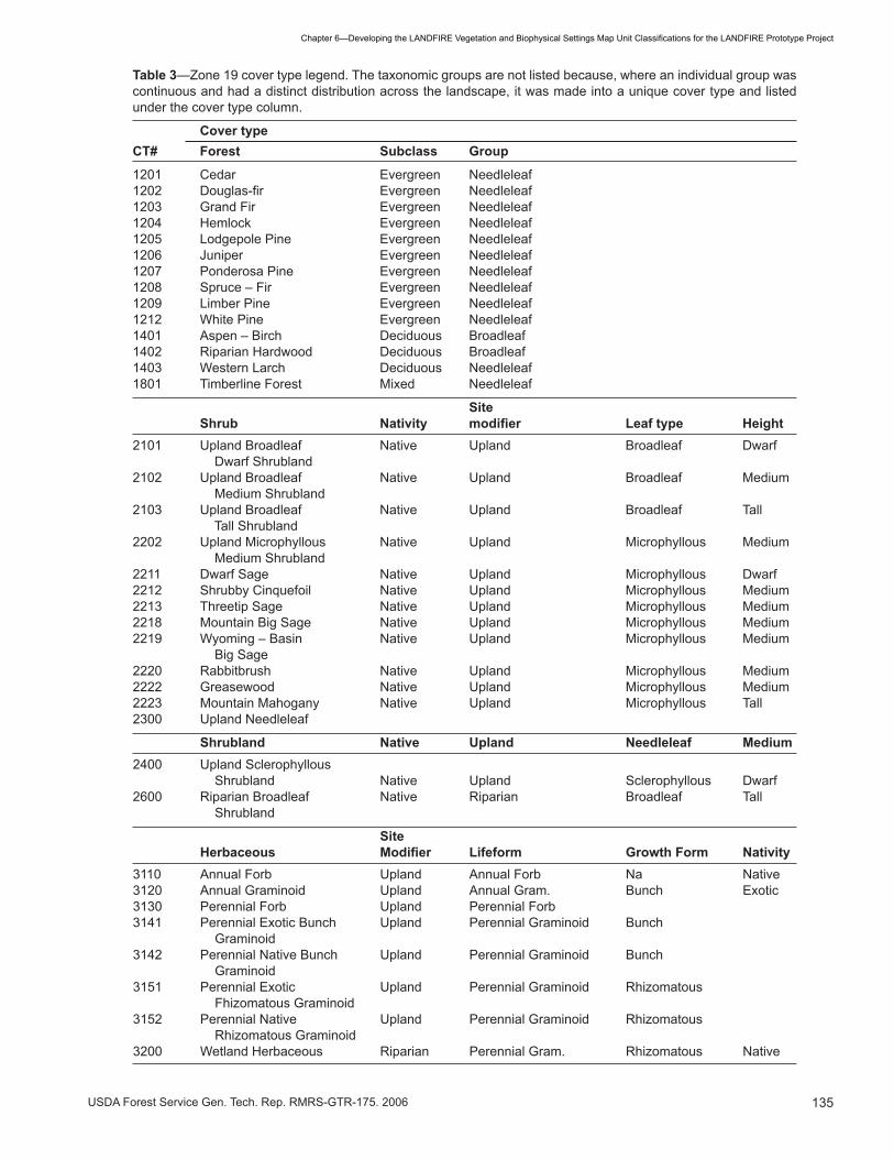
Table 3—Zone �9 cover type legend. The taxonomic groups are not listed because, where an individual group was continuousandhadadistinctdistributionacrossthelandscape,itwasmadeintoauniquecovertypeandlistedunder the cover type column.
Cover typeCT# Forest Subclass Group
�20� Cedar Evergreen Needleleaf1202 Douglas-fir Evergreen Needleleaf�20� Grand Fir Evergreen Needleleaf�20� Hemlock Evergreen Needleleaf�205 Lodgepole Pine Evergreen Needleleaf�206 Juniper Evergreen Needleleaf�207 Ponderosa Pine Evergreen Needleleaf1208 Spruce–Fir Evergreen Needleleaf�209 Limber Pine Evergreen Needleleaf�2�2 White Pine Evergreen Needleleaf1401 Aspen–Birch Deciduous Broadleaf��02 Riparian Hardwood Deciduous Broadleaf��0� Western Larch Deciduous Needleleaf�80� Timberline Forest Mixed Needleleaf
Site Shrub Nativity modifier Leaf type Height2�0� Upland Broadleaf Native Upland Broadleaf Dwarf Dwarf Shrubland2�02 Upland Broadleaf Native Upland Broadleaf Medium Medium Shrubland2�0� Upland Broadleaf Native Upland Broadleaf Tall Tall Shrubland2202 Upland Microphyllous Native Upland Microphyllous Medium Medium Shrubland22�� Dwarf Sage Native Upland Microphyllous Dwarf2212 ShrubbyCinquefoil Native Upland Microphyllous Medium22�� Threetip Sage Native Upland Microphyllous Medium22�8 Mountain Big Sage Native Upland Microphyllous Medium2219 Wyoming–Basin Native Upland Microphyllous Medium Big Sage2220 Rabbitbrush Native Upland Microphyllous Medium2222 Greasewood Native Upland Microphyllous Medium222� Mountain Mahogany Native Upland Microphyllous Tall2�00 Upland Needleleaf
Shrubland Native Upland Needleleaf Medium2�00 Upland Sclerophyllous Shrubland Native Upland Sclerophyllous Dwarf2600 Riparian Broadleaf Native Riparian Broadleaf Tall Shrubland
Site Herbaceous Modifier Lifeform Growth Form Nativity���0 Annual Forb Upland Annual Forb Na Native��20 Annual Graminoid Upland Annual Gram. Bunch Exotic���0 Perennial Forb Upland Perennial Forb���� Perennial Exotic Bunch Upland Perennial Graminoid Bunch Graminoid���2 Perennial Native Bunch Upland Perennial Graminoid Bunch Graminoid��5� Perennial Exotic Upland Perennial Graminoid Rhizomatous Fhizomatous Graminoid��52 Perennial Native Upland Perennial Graminoid Rhizomatous Rhizomatous Graminoid�200 Wetland Herbaceous Riparian Perennial Gram. Rhizomatous Native

��6 USDA Forest Service Gen. Tech. Rep. RMRS-GTR-�75. 2006
Chapter6—DevelopingtheLANDFIREVegetationandBiophysicalSettingsMapUnitClassificationsfortheLANDFIREPrototypeProject
plots in Zone 19, had so few species listed that it did not contain sufficient information to classify plots using more than one plant taxa. Usually, the dominant species on the plot was named at the species level, but other taxonomic levels were sometimes used. A generic level (for example, Purshia) was used when it was specific enough to identify a CT, and a sub-species level was used sometimes when a species level was not detailed enough to classify the CT, for example, mountain big sagebrush (Artemisia tridentata ssp. vaseyana). Most often, however, generic level dominant species were not distinctive enough for LANDFIRE CTs in Zone 19. For example, when Acer or Abies were described as the dominant species on a plot, they were considered too taxonomically coarse for LANDFIRE map unit purposes and were not used in the classification process. Many forested plots in Zone 19 were dominated typically by one or two taxa, and the classification of these species into CTs was relatively simple, as was the arrangement of the CTs into a hierarchy. Forest CTs were easily identified from plot data as only two plots of 6,532 forested plots were not classified to a CT. These two plots listed “Pinus” as the dominant tree species, which was not sufficient for classification. However, most of the forest plot data listed the full species name, and the dominant species (or group of dominant spe-cies) determined the CT. For example, ponderosa pine, Douglas-fir, and lodgepole pine typically form single species-dominated stands that occupy vast areas of the West. In such instances, the CT was simply the domi-nant species. In other instances, a few dominant species were grouped into a single CT, such as in the case of
the Timberline Pine CT. These CTs were grouped into coarser hierarchical levels by leaf type and then leaf phenology. Species mixtures in other areas, such as the Sierra Nevada or the eastern U.S., where many species could potentially define the dominant species on a plot, may require different approaches to classification. The Zone 19 CT hierarchy can be found in table 4. Shrubs presented unique challenges to the development of the LANDFIRE mapping classification due to the number of taxa, mixes in species composition, and the generally broad ecological amplitude of shrub species. The process of assigning dominant species to shrub plot data was the same as for forested plots; they were assigned according to the single taxa with the highest cover on the plot. Fifty-two of 3,352 plots (1.5%) remained unclassified because the plot data did not describe the species sufficiently. As with forest types, the dominant types were then grouped into taxonomic and physiog-nomic categories. However, the criteria for assigning the categories to shrub types were different from the criteria used to assign categories to forest types, and the resulting hierarchy had five levels above the dominant species because these different life forms have different criteria by which to group them (table 5). We considered using the NVCS classification criteria (Grossman and others 1998) for the shrub classification but discovered that certain criteria did not meet LAND-FIRE design criteria and guidelines. For example, we chose to exclude the xeromorphic leaf type (adapted to drought) since it is not always distinguishable (from a remote sensing or mapping standpoint) from the micro-phyllous (small) or sclerophyllous (small and leathery,
Table 4—Zone19forestcovertypehierarchystructureanddefinitions.
Levels Descriptions Categories/examples
Subclass Coarse classes based on leaf phenology. Evergreen, Deciduous, Mixed Evergreen-Deciduous
Group Classes based general leaf type. Broadleaf, Needleleaf
Sitemodifier Classesbasedprimarilyonsimilarphysiognomy, PonderosaPine,TimberlinePine, successional ecology, and site characteristics. We also considered the “mappability” of similar vegetation types from other projects and advice given by remote sensing experts.
Dominantspecies Aspeciesintheuppermostvegetationlayerthat Douglas-fir indicates a recurring plant community as determined from the plot data.

��7USDA Forest Service Gen. Tech. Rep. RMRS-GTR-�75. 2006
Chapter6—DevelopingtheLANDFIREVegetationandBiophysicalSettingsMapUnitClassificationsfortheLANDFIREPrototypeProject
drought adapted) leaf types. The terms evergreen and deciduous were also discarded due to confusion in ap-plying the terms to specific taxa and the fact that two taxa that are similar morphologically may be different in leaf phenology. Distinguishing among drought deciduous shrubs that typically occur in arid environments, cold deciduous shrubs, and evergreen shrubs was problem-atic because it is difficult to know, based simply on leaf morphology, the phenology of a plant, whether a plant is evergreen or deciduous, and what causes it to drop its leaves. Herbaceous CTs differed from forest and shrub CTs in the vast number of species within a zone and across the U.S. and because of the introduction and dominance of many exotic species – which made it difficult to use a single species to determine a unique CT. Only 30 of the 731 (4%) herbaceous plots were not classified to a CT. Unlike the forested plots, most of the dominant
species were grouped in order to result in a reasonable number of CTs for LANDFIRE mapping purposes. Her-baceous-dominated plots were grouped into CTs based on a small number of criteria that can be consistently applied across the country. The hierarchical categories include site characteristics, growth characteristics, and nativity of the dominant taxa (table 6). The classification does not identify systems such as desert grassland, mixed grass prairie, tall grass prairie, and short grass prairie; however, these types can be delineated using geographic and ecological criteria, if necessary. Descriptions of all the Zone 19 CTs are found in appendix 6-E. For the prototype effort, we required that any CT gen-erated for Zone 19 must describe a western community at the landscape level; that is, it had to cover at least one percent of the western landscape. The amount of cover defining a landscape-level community may differ in other regions of the U.S. This criterion applied mainly to CTs
Table 5—Zone19shrubcovertypehierarchystructureanddefinitions.
Level Descriptions Categories
Nativity Categories refer to whether the dominant Native, Exotic species occurred in North America prior to western settlement or was introduced to North America and is growing naturally in wild areas without cultivation.
Sitemodifier Covertypelevelbasedonsitecharacteristics. FacultativeUpland,Riparian Specifically,dominantspeciesmayoccurin upland and riparian-wetland areas or are obligate riparian-wetland.
Leaf type Map units based on leaf type. Broadleaf, Microphyllous, Needleleaf (scale-leaf), Sclerophyllous, Succulents
Height Broad, mature height categories of the Dwarf (<� ft), dominance types. Medium (�-8 ft) Tall (>8 ft)
Taxonomic group Grouping of dominant species based on shared taxonomic and morphologic characteristics. The taxonomic level on which the grouping is based may occur atthespecific,generic,orfamilylevel depending on the taxonomic level of the dominance type. We also considered the “mappability” of similar vegetation types from other projects and advice given by remote sensing experts.
Dominant species A species in the uppermost vegetation layer Big sagebrush that indicates a recurring plant community as determined from the plot data.

��8 USDA Forest Service Gen. Tech. Rep. RMRS-GTR-�75. 2006
Chapter6—DevelopingtheLANDFIREVegetationandBiophysicalSettingsMapUnitClassificationsfortheLANDFIREPrototypeProject
that were also dominant species. For example, we could have grouped mountain big sage, rabbitbrush, shrubby cinquefoil, threetip sage, or Wyoming big sagebrush under the Upland Microphyllous Medium Shrublands CT. Instead, we considered these dominant species individually as CTs because of their abundance across the western U.S., their ecological importance, and/or the large total number of plots available within each type in the Zone 19 reference data. However, we grouped bitterbrush, horsebrush, shrubby chenopods, silver sage, and snakeweed into the Upland Microphyllous Medium Shrublands CT because the number of plots classified to the individual dominant species was few, ranging from 10 to 16 plots each. If a CT was assigned to less than 20 to 30 plots, the CT was either unused or grouped with a similar type, if one existed. For example, only one plot (dominated by Yucca glauca) fell within the succulent leaf type. Due to its minor importance and single plot number, succulent was not used as a CT. The data-driven nature of the bottom-up classification approach was the main strength of the LANDFIRE classification approach used for Zone 19. This approach enabled us to classify all plot data that had detailed species lists. However, there are drawbacks to this data-driven approach. The bottom-up approach is completely dependent upon reference plot data quality and quantity. Cover types that are represented by too few plots within
a zone were not mapped because the Landsat-based mapping process requires a minimum number of plots from which to develop training sites (Zhu and others, Ch. 8). Moreover, it was difficult to build a hierarchy with data from a single zone that would encompass all of the CTs that would be encountered across the entire United States and allow for incorporation of new classes as they were identified. Finally, the data driven approach requires that the plot data be available before the classification can begin, which may or may not be realistic. Modelers (Long and others, Ch. 9) found the 15 shrub types identified in Zone 19 too numerous; as a result, even though they were “model-able,” the number of suc-cession classes found in some of the pathways became inflated. It was our intention that LANDFIRE vegeta-tion modelers would have more choice in determining what scale of CT to use; they could collapse or expand the definition of the CT depending upon their needs. It was a “scalable” system. However, the modelers did not take advantage of the scalability of the CTs primarily because of a misunderstanding surrounding this design. In general, vegetation modelers (Long and others, Ch. 9) found it confusing to use CTs from different hierarchical levels throughout the succession pathway creation. In addition, the LANDFIRE vegetation mapping team did not want flexibility in regards to which CTs they would map. They requested that we simply give them a
Table 6—Zone19herbaceouscovertypehierarchystructureanddefinitions.
Levels Descriptions Categories
Sitemodifier Mapunitlevelbasedonsitecharacteristics. Upland Specifically,dominantspeciesmayoccurin upland and riparian-wetland areas or are obligate riparian-wetland.
Life form Map unit based on leaf type and periodicity Annual Forb, Perennial Forb, Annual of herbaceous plants Graminoid, Perennial Graminoid
Growth form Map unit based on the growing habits of Bunch-forming, Rhizomatous graminiods (not applicable to forbs).
Nativity Categories refer to whether the dominant Native, Exotic species occurred in North America prior to western settlement or was introduced to North America and is growing naturally in wild areas without cultivation.
Dominant species A species in the uppermost vegetation layer Cheatgrass that indicates a recurring plant community as determined from the plot data.

��9USDA Forest Service Gen. Tech. Rep. RMRS-GTR-�75. 2006
Chapter6—DevelopingtheLANDFIREVegetationandBiophysicalSettingsMapUnitClassificationsfortheLANDFIREPrototypeProject
CT legend for Zone 19 and they would attempt to map those types. They determined that a flexible legend would complicate the process greatly. The legend provided was considered “mappable.” As with Zone 16 CTs, the LANDFIRE fuel mapping team found the Zone 19 CTs useful. Use of the bot-tom-up classification approach, in addition to the fact that many of the classification criteria were based on vegetation characteristics (such as leaf type or growth from), facilitated a clear description of the wildland fuel characteristics for many of the CTs. Some of the graminoid CTs, however, did not adequately distinguish between fine and coarse grass sites, which posed the same problem encountered in Zone 16 with grass fuel models (Keane and others, Ch. 12).
Potential Vegetation Type We established four hierarchical levels to define the potential vegetation types (PVTs) and assigned indicator species to each PVT. Species within the PVTs in each level share similar site characteristics. Level 1, the top level, designates the life form of the PVT as forest, shru-bland, or herbaceous. The CTs that would potentially dominate the site in the absence of disturbance form the next two lower levels of the PVT classification. We named level 2 according to either the CT or the species that was the most shade-tolerant, such as a “Spruce-Fir cover type,” or the species or CT with the narrowest ecological amplitude that could occur on a shrub or herbaceous site, such as a “Riparian Shrub cover type.” Level 3 was named according to the indicator species on that site or the geographical setting that differenti-ates fire regimes of the potential dominant vegetation type, an example being “montane.” A fourth level was added to discriminate between major seral vegetation types of the PVTs because they represented an even finer resolution with which to identify unique site conditions. Level 4 was named according to the secondary indica-tor species, CT, or a geographical term such as “north.” We identified a PVT by a linking the names in levels 2 through 4 with forward slashes (/). PVTs could also be collapsed back to coarser levels. Finally, a classifier key or sequence table was developed to automate the linkage of plots in the LFRDB to PVT classes using the indicator species (Caratti, Ch. 4). We calculated the proportions of CTs occurring in each PVT using plot data from the LFRDB. The LAND-FIRE vegetation mapping team used this information to limit the number of specific CTs that could possibly occur in each PVT. The probabilities generated from reference plot data form the foundation for evaluating
the probability of CTs existing on sites with specific biophysical characteristics. This, in turn, allows a mea-sure of certainty with regard to whether certain CTs can occur in specific areas on the map. Incorporating these probabilities into the LANDFIRE vegetation mapping process distinguishes the LANDFIRE mapping process from other broad-scale vegetation mapping efforts. A hierarchically organized list of the PVTs developed for zones 16 and 19 can be found in tables 7 and 8, respec-tively. Appendices 6-F and 6-G provide descriptions of the PVTs created for zones 16 and 19, respectively. Additional information on how the PVT classification formed the basis for vegetation modeling may be found in Long and others (Ch. 9). The LANDFIRE fuel mapping team found that the number of PVT map classes was adequate to represent different site conditions that may influence surface and canopy fuel. The scale of the fire behavior fuel models and fuel loading models was much coarser than that of the PVT classification. To map surface fire behavior fuel models and fuel loading models, the LANDFIRE fuel mapping team used the upper levels of the PVT classification as a stratification to identify unique en-vironmental site conditions. A general description of environmental site conditions was adequate for creating fire behavior fuel maps because few fuel classes exist for the entire United States. However, when mapping the Fuel Characteristic Classification System (FCCS) national fuelbeds, the LANDFIRE fuel mapping team found the levels 2 and 3 PVT classes helpful in determin-ing the crosswalks between PVTs and fuelbeds (Keane and others, Ch. 12; Sandberg and others 2001).
Structural Stage The structural stages (SS) for Zone 16 were composed of 16 classes based on a matrix of canopy density classes and height classes by life form (table 9). However, as the LANDFIRE vegetation modelers combined the SS units developed for Zone 16 with CT classes to represent seral stages in the succession pathways, they found the two height classes per life form insufficient. This insufficiency became especially evident when the modelers needed to use a mixed CT to represent a broad category of vegetation and had to use multiple seral stages in multiple pathways; however, the model-ers had the use of only two height classes with which to describe distinctive seral stages within a CT. To allow more flexibility with regard to illustrating the age and structure of a CT, we needed a better way to describe situations in which the CT was general but potential seral stages were more floristically narrow . In response, for

��0 USDA Forest Service Gen. Tech. Rep. RMRS-GTR-�75. 2006
Chapter6—DevelopingtheLANDFIREVegetationandBiophysicalSettingsMapUnitClassificationsfortheLANDFIREPrototypeProject
Table 7—Zone �6 potential vegetation type partitioned by hierarchical level.
PVT# Level 1 Level 2 Level 3 Level 4
1601 Forest Spruce–Fir BlueSpruce1602 Forest Spruce–Fir BlueSpruce LodgepolePine1603 Forest Spruce–Fir Spruce–Fir1604 Forest Spruce–Fir Spruce–Fir LodgepolePine�6�� Forest Grand Fir White Fir�6�2 Forest Grand Fir White Fir Maple1621 Forest Douglas-fir TimberlinePine1622 Forest Douglas-fir Douglas-fir1623 Forest Douglas-fir LodgepolePine�6�� Forest Timberline Pine�6�2 Forest Ponderosa Pine�6�� Forest Lodgepole Pine�6�� Forest Aspen1641 Forest Pinyon–Juniper MountainBigSagebrush North1642 Forest Pinyon–Juniper MountainBigSagebrush South1643 Forest Pinyon–Juniper Wyoming–BasinBig Sagebrush North1644 Forest Pinyon–Juniper Wyoming–BasinBig Sagebrush South1645 Forest Pinyon–Juniper MountainMahogany1646 Forest Pinyon–Juniper GambelOak�65� Shrubland Blackbrush�652 Shrubland Salt Desert Shrub�65� Herbaceous Warm Herbaceous�66� Shrubland Dwarf Sagebrush1662 Shrubland Wyoming–BasinBig Sagebrush�66� Shrubland Mountain Big Sagebrush�67� Forest Riparian Hardwood�672 Shrubland Riparian Shrub�67� Herbaceous Wetland Herbaceous�680 Herbaceous Alpine
Zone 19, the vegetation modelers were consulted and a third height map unit was incorporated for both tree and shrub vegetation types (table 10). As a result, the LANDFIRE vegetation modelers had more groups with which to characterize seral stage, and fewer changes had to be made to rectify the SS map with the PVT and CT maps. For example, a tree SS would be valid for a forest or woodland CT. The SS threshold breaks deemed adequate for veg-etation modeling did not suffice for describing diverse wildland fuel characteristics when applied to fuel maps in zones 16 and 19. Two classes for vegetation cover, while perhaps increasing map accuracy (Vogelman and others, Ch. 13), were not sufficient for the derivation of fuel characteristics. In addition, the height classes were insufficient for portraying surface and canopy fuel. Many fire behavior fuel models require specific structural
thresholds that are often different from those used by the LANDFIRE vegetation modelers. For example, whereas a five-meter class was sufficient to represent early seral forest in the succession models (Long and others, Ch. 9), this map unit was not fine enough for use in surface fuel descriptions where surface fuel height ranges only from 0 to 1.8 meters (Keane, Ch. 12).
Recommendations for National Implementation _________________ To apply the LANDFIRE mapping approach across the United States, we recommend that a vegetation working group (VWG) be formed to ensure that the LANDFIRE classification systems meet national clas-sification and mapping standards. The VWG should consist of members of the LANDFIRE technical teams
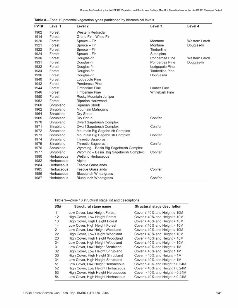
���USDA Forest Service Gen. Tech. Rep. RMRS-GTR-�75. 2006
Chapter6—DevelopingtheLANDFIREVegetationandBiophysicalSettingsMapUnitClassificationsfortheLANDFIREPrototypeProject
Table 8—Zone �9 potential vegetation types partitioned by hierarchical levels.
PVT# Level 1 Level 2 Level 3 Level 4
�902 Forest Western Redcedar1914 Forest GrandFir–WhiteFir1920 Forest Spruce–Fir Montane WesternLarch1921 Forest Spruce–Fir Montane Douglas-fir1922 Forest Spruce–Fir Timberline1924 Forest Spruce–Fir Subalpine1930 Forest Douglas-fir PonderosaPine WesternLarch1931 Forest Douglas-fir PonderosaPine Douglas-fir1932 Forest Douglas-fir LodgepolePine1934 Forest Douglas-fir TimberlinePine1936 Forest Douglas-fir Douglas-fir�9�0 Forest Lodgepole Pine�9�2 Forest Ponderosa Pine�9�� Forest Timberline Pine Limber Pine�9�6 Forest Timberline Pine Whitebark Pine�950 Forest Rocky Mountain Juniper�952 Forest Riparian Hardwood�960 Shrubland Riparian Shrub�962 Shrubland Mountain Mahogany�96� Shrubland Dry Shrub�965 Shrubland Dry Shrub Conifer�970 Shrubland Dwarf Sagebrush Complex�97� Shrubland Dwarf Sagebrush Complex Conifer�972 Shrubland Mountain Big Sagebrush Complex�97� Shrubland Mountain Big Sagebrush Complex Conifer�97� Shrubland Threetip Sagebrush�975 Shrubland Threetip Sagebrush Conifer1976 Shrubland Wyoming–BasinBigSagebrushComplex1977 Shrubland Wyoming–BasinBigSagebrushComplex Conifer�980 Herbaceous Wetland Herbaceous�982 Herbaceous Alpine�98� Herbaceous Fescue Grasslands�985 Herbaceous Fescue Grasslands Conifer�986 Herbaceous Bluebunch Wheatgrass�987 Herbaceous Bluebunch Wheatgrass Conifer
Table 9—Zone �6 structural stage list and descriptions.
SS# Structural stage name Structural stage description
11 LowCover,LowHeightForest Cover≤40%andHeight≤10M12 HighCover,LowHeightForest Cover>40%andHeight≤10M �� High Cover, High Height Forest Cover > �0% and Height > �0M14 LowCover,HighHeightForest Cover≤40%andHeight>10M21 LowCover,LowHeightWoodland Cover≤40%andHeight≤10M22 HighCover,LowHeightWoodland Cover>40%andHeight≤10M 2� High Cover, High Height Woodland Cover > �0% and Height > �0M24 LowCover,HighHeightWoodland Cover≤40%andHeight>10M31 LowCover,LowHeightShrubland Cover≤40%andHeight≤1M32 HighCover,LowHeightShrubland Cover>40%andHeight≤1M �� High Cover, High Height Shrubland Cover > �0% and Height > �M34 LowCover,HighHeightShrubland Cover≤40%andHeight>1M51 LowCover,LowHeightHerbaceous Cover≤40%andHeight≤0.24M52 HighCover,LowHeightHerbaceous Cover>40%andHeight≤0.24M 5� High Cover, High Height Herbaceous Cover > �0% and Height > 0.2�M54 LowCover,HighHeightHerbaceous Cover≤40%andHeight>0.24M
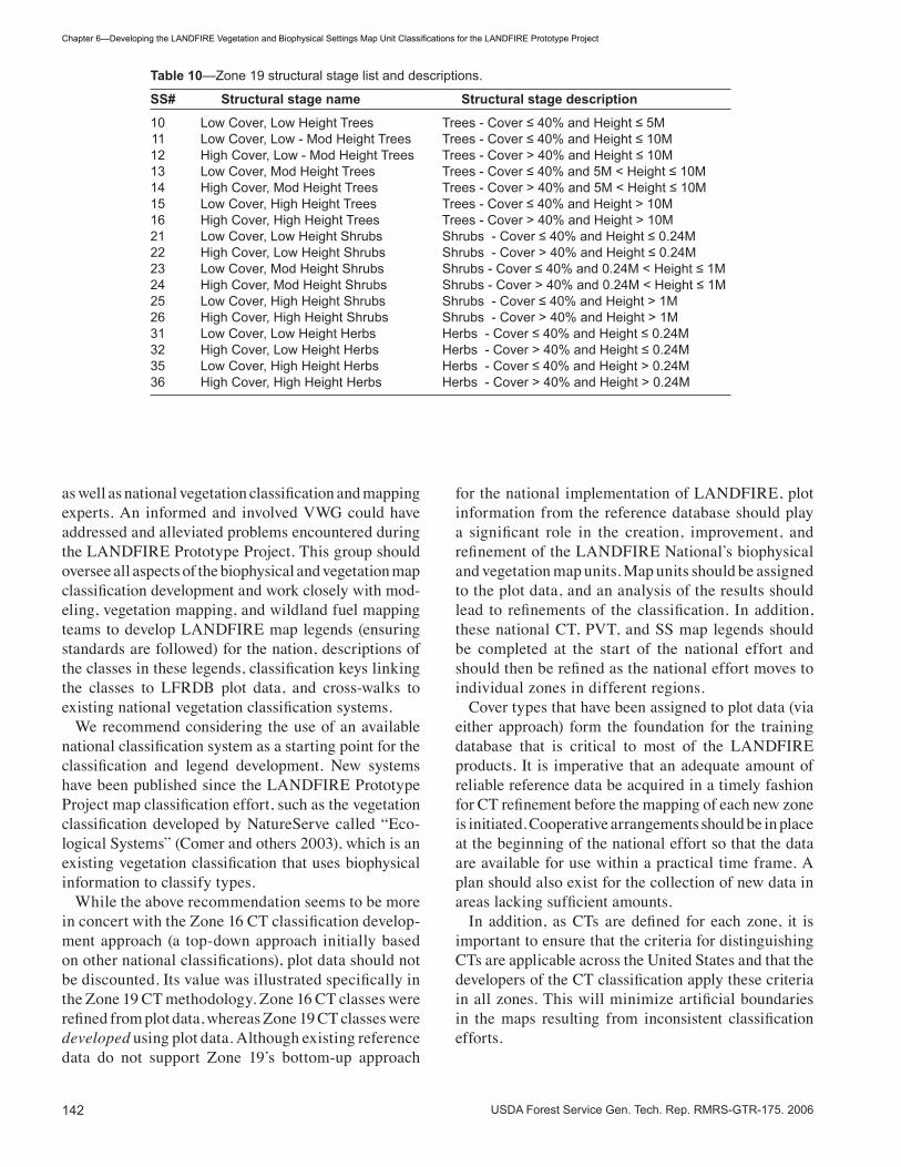
��2 USDA Forest Service Gen. Tech. Rep. RMRS-GTR-�75. 2006
Chapter6—DevelopingtheLANDFIREVegetationandBiophysicalSettingsMapUnitClassificationsfortheLANDFIREPrototypeProject
as well as national vegetation classification and mapping experts. An informed and involved VWG could have addressed and alleviated problems encountered during the LANDFIRE Prototype Project. This group should oversee all aspects of the biophysical and vegetation map classification development and work closely with mod-eling, vegetation mapping, and wildland fuel mapping teams to develop LANDFIRE map legends (ensuring standards are followed) for the nation, descriptions of the classes in these legends, classification keys linking the classes to LFRDB plot data, and cross-walks to existing national vegetation classification systems. We recommend considering the use of an available national classification system as a starting point for the classification and legend development. New systems have been published since the LANDFIRE Prototype Project map classification effort, such as the vegetation classification developed by NatureServe called “Eco-logical Systems” (Comer and others 2003), which is an existing vegetation classification that uses biophysical information to classify types. While the above recommendation seems to be more in concert with the Zone 16 CT classification develop-ment approach (a top-down approach initially based on other national classifications), plot data should not be discounted. Its value was illustrated specifically in the Zone 19 CT methodology. Zone 16 CT classes were refined from plot data, whereas Zone 19 CT classes were developed using plot data. Although existing reference data do not support Zone 19’s bottom-up approach
for the national implementation of LANDFIRE, plot information from the reference database should play a significant role in the creation, improvement, and refinement of the LANDFIRE National’s biophysical and vegetation map units. Map units should be assigned to the plot data, and an analysis of the results should lead to refinements of the classification. In addition, these national CT, PVT, and SS map legends should be completed at the start of the national effort and should then be refined as the national effort moves to individual zones in different regions. Cover types that have been assigned to plot data (via either approach) form the foundation for the training database that is critical to most of the LANDFIRE products. It is imperative that an adequate amount of reliable reference data be acquired in a timely fashion for CT refinement before the mapping of each new zone is initiated. Cooperative arrangements should be in place at the beginning of the national effort so that the data are available for use within a practical time frame. A plan should also exist for the collection of new data in areas lacking sufficient amounts. In addition, as CTs are defined for each zone, it is important to ensure that the criteria for distinguishing CTs are applicable across the United States and that the developers of the CT classification apply these criteria in all zones. This will minimize artificial boundaries in the maps resulting from inconsistent classification efforts.
Table 10—Zone �9 structural stage list and descriptions.
SS# Structural stage name Structural stage description
10 LowCover,LowHeightTrees Trees-Cover≤40%andHeight≤5M11 LowCover,Low-ModHeightTrees Trees-Cover≤40%andHeight≤10M12 HighCover,Low-ModHeightTrees Trees-Cover>40%andHeight≤10M13 LowCover,ModHeightTrees Trees-Cover≤40%and5M<Height≤10M14 HighCover,ModHeightTrees Trees-Cover>40%and5M<Height≤10M15 LowCover,HighHeightTrees Trees-Cover≤40%andHeight>10M �6 High Cover, High Height Trees Trees - Cover > �0% and Height > �0M21 LowCover,LowHeightShrubs Shrubs-Cover≤40%andHeight≤0.24M22 HighCover,LowHeightShrubs Shrubs-Cover>40%andHeight≤0.24M23 LowCover,ModHeightShrubs Shrubs-Cover≤40%and0.24M<Height≤1M24 HighCover,ModHeightShrubs Shrubs-Cover>40%and0.24M<Height≤1M25 LowCover,HighHeightShrubs Shrubs-Cover≤40%andHeight>1M 26 High Cover, High Height Shrubs Shrubs - Cover > �0% and Height > �M31 LowCover,LowHeightHerbs Herbs-Cover≤40%andHeight≤0.24M32 HighCover,LowHeightHerbs Herbs-Cover>40%andHeight≤0.24M35 LowCover,HighHeightHerbs Herbs-Cover≤40%andHeight>0.24M �6 High Cover, High Height Herbs Herbs - Cover > �0% and Height > 0.2�M

���USDA Forest Service Gen. Tech. Rep. RMRS-GTR-�75. 2006
Chapter6—DevelopingtheLANDFIREVegetationandBiophysicalSettingsMapUnitClassificationsfortheLANDFIREPrototypeProject
The CT classification should be developed in concert with the PVT and SS classifications. Developers should work together to ensure that all classes are ecologically consistent between classification systems. We recom-mend that the developers be the same group for all the biophysical and vegetation map classifications. A vegetation working group should be the arbitrator of all LANDFIRE classification systems to ensure consistency. In the LANDFIRE Prototype, the PVT and CT map legends had to be adjusted even after the maps were created because multiple versions of each classification were available and used, resulting in inconsistency be-tween legends. For example, at one point, there was an “Herbaceous” PVT, but there was not an “Herbaceous” CT. These classifications must be consistent from the beginning so that the maps made from them correspond ecologically. In addition, LANDSUMv4 (Pratt and oth-ers, Ch. 10) requires that the maps be consistent with the succession pathway models described in Long and others, Ch. 9. Throughout the development of the LANDFIRE veg-etation classifications, we received feedback regarding our use of certain terminology and definitions. We found that the potential vegetation concept is not uniformly accepted among vegetation ecologists, especially range scientists. Alternative terminology, such as potential natural vegetation group (PNVG), is also not well received by some specialists. For national implementa-tion, we recommend that the term biophysical setting (BpS) be used instead of PVT because this term applies to a wide range of environmental conditions in which vegetation occurs and does not imply an assumption of linear succession processes or the integration (or not) of disturbance into the classification system. We also recommend that the term cover type (CT) be changed to existing vegetation (EV) to more clearly indicate what is being represented. Another problem that affected the PVT develop-ment particularly was the numerous personnel changes throughout the development process. The instability of the personnel resource available to the LANDFIRE Prototype Project resulted in inconsistent and sometimes conflicting approaches and insufficient documentation. For example, some ecologists tended to split biophysical characteristics, whereas others tended to lump them; the PVT classification therefore went through many phases of adjustment and revision. A clearly documented and detailed explanation of the purpose of the PVT classifica-tion would help developers understand their objectives, and documented procedures would help developers avoid
conflicts in methodologies. Again, the VWG should oversee this effort throughout the implementation of LANDFIRE National to ensure standards are followed as PVTs are classified within and across mapping zones. As mentioned above, the scalable nature of the PVT classification allowed flexibility in representing PVTs, but this characteristic was not utilized in the prototype effort. By choosing not to employ the scalable nature of the classification (not grouping to broader and thus fewer classes), the LANDFIRE vegetation modelers ended up with succession models that were too numerous and complicated, with over 40 CTs in the succession pathway for many PVTs in both prototype mapping zones (Long and others, Ch. 9). We do not recommend this level of complexity in vegetation modeling for LANDFIRE National. Various levels of the PVT classes could be used to represent different scales and interpretations of potential vegetation. For example, level 1 could be used to represent major environmental settings, as indicated by life form. In another example, level 3 – which dif-ferentiates between the historical fire regimes of PVTs – could be used as a link to potential natural vegetation types, which include natural disturbance in their defini-tions and descriptions. We recommend that vegetation modelers use coarser scale PVTs (and CTs) to simplify the models.
Conclusion _____________________ To meet the needs of vegetation and fuel mappers, we developed three ecologically consistent vegetation and biophysical map unit classifications that were identifi-able, scaleable, mappable, and model-able. We found that successful implementation of such an endeavor requires detailed knowledge of many vegetation systems and their succession, fuel, and fire dynamics; awareness of differing scientific approaches to vegetation classi-fication; recognition and understanding of the varying user needs; and recognition and understanding of the varying needs relating to different areas of the country. We emphasize the importance of creating a vegetation working group for the implementation of LANDFIRE National or any similar large scale effort. Lastly, cen-tralized coordination and oversight of the development of these map unit classifications is crucial to promote the efficiency, consistency, and high scientific standards required for this type of project. For further project information, please visit the LAND-FIRE website at www.landfire.gov.

��� USDA Forest Service Gen. Tech. Rep. RMRS-GTR-�75. 2006
Chapter6—DevelopingtheLANDFIREVegetationandBiophysicalSettingsMapUnitClassificationsfortheLANDFIREPrototypeProject
The Authors ____________________ Jennifer L. Long is a Research Scientist with Systems for Environmental Management working with the USDA Forest Service, Rocky Mountain Research Station, Mis-soula Fire Sciences Laboratory (MFSL). She received a B.A degree in Environmental Studies/Geography from the University of California, Los Angeles (1994) and an M.S. degree in Natural Resources with a Forestry option from Humboldt State University (2000). Long’s research has focused on fuel classification, fuel map-ping, and database development. She began her career by serving three seasons as a wildland fire fighter for the Forest Service and as a tree researcher for Simpson Timber Company. She then moved on to the Fire and Environmental Research Applications (FERA) Team at the Pacific Northwest (PNW) Research Station to work on the Fuel Characteristic Classification System (FCCS). She currently works on the LANDFIRE Project at MFSL where her responsibilities include the design of protocols to classify and map fuel and fire behavior fuel models based on vegetation and biophysical variables, the development of a national vegetation mapping clas-sification, and the linkage of the FCCS to LANDFIRE fuel maps. Melanie Miller is a Fire Ecologist with the USDOI Bureau of Land Management, Office of Fire and Avia-tion, Boise, Idaho and is stationed at the USDA Forest Service, Rocky Mountain Research Station, Missoula Fire Sciences Laboratory (MFSL). Since 2001, Miller has worked on vegetation mapping for the LANDFIRE Prototype Project, co-developed a model that qualita-tively predicts understory plant response to fire, and recently took responsibility as Steering Group Chair for the Third International Fire Ecology and Management Congress. Her past work for the Bureau of Land Man-agement includes the development and implementation of fire management planning procedures for the west-ern U. S. and Alaska; representation of fire and smoke management interests for the Interior Columbia Basin Ecosystem Management Project; development of pre-scribed fire monitoring guidance; participation in course development for the national interagency prescribed fire curriculum; Steering Group member for Rx510: Applied Fire Effects; and the writing and co-authoring of technical papers on subjects that include mechanics of vegetation recovery after fire, the Fire Effects Information System, and fuel moisture sampling. Miller earned a B.S. honors degree in Physical Geography from the University of Calgary in 1972 and an M.S. degree in Forest Fire Sci-ence from the University of Montana in 1976.
James P. Menakis is a Forester with the USDA Forest Service, Rocky Mountain Research Station, Missoula Fire Sciences Laboratory (MFSL). Since 1990, Mena-kis has worked on various research projects related to fire ecology at the community and landscape levels for the Fire Ecology and Fuels Project. Currently, he is working on the Rapid Assessment, which is part of the LANDFIRE Project. Menakis has recently worked on mapping historical natural fire regimes, fire regime condition classes (FRCC), wildland fire risk to flam-mable structures for the conterminous United States, and relative FRCC for the western United States. Before that, he was the GIS Coordinator of the Landscape Ecology Team for the Interior Columbia River Basin Scientific Assessment Project and was involved with mapping FARSITE layers for the Gila Wilderness and the Selway-Bitterroot Wilderness. Menakis earned his B.S. degree in Forestry in 1985 and his M.S. degree in Environmental Studies in 1994, both from the University of Montana, Missoula. Robert E. Keane is a Research Ecologist with the USDA Forest Service, Rocky Mountain Research Sta-tion, Missoula Fire Sciences Laboratory (MFSL). Since 1985, Keane has developed various ecological computer models for the Fire Effects Project for research and man-agement applications. His most recent research includes the development of a first-order fire effects model, the construction of mechanistic ecosystem process models that integrate fire behavior and fire effects into succes-sion simulation, the restoration of whitebark pine in the Northern Rocky Mountains, the spatial simulation of successional communities on landscapes using GIS and satellite imagery, and the mapping of fuels for fire behavior prediction. He received his B.S. degree in For-est Engineering in 1978 from the University of Maine, Orono, his M.S. degree in Forest Ecology in 1985 from the University of Montana, and his Ph.D. degree in For-est Ecology in 1994 from the University of Idaho.
Acknowledgments _______________ We thank John Caratti of Systems for Environmental Management and Jim Vogelmann of Science Applica-tions International Corporation for their direction on map unit classification development. The support of Don Long (Missoula Fire Sciences Laboratory), Karen Short (Systems for Environmental Management), and Mary Manning (U.S. Forest Service – Northern Region) has also been invaluable to this map unit classification effort. Finally, we would like to recognize Christine Frame of Systems for Environmental Management for

��5USDA Forest Service Gen. Tech. Rep. RMRS-GTR-�75. 2006
Chapter6—DevelopingtheLANDFIREVegetationandBiophysicalSettingsMapUnitClassificationsfortheLANDFIREPrototypeProject
her effort in organizing this document (and the authors) and her thorough editorial review. Thanks to all for their thoughtfulness and time.
References _____________________Arno, S. F.; Simmerman, D.G.; Keane, R. E. 1985. Characterizing
succession within a forest habitat type - an approach designed for resource managers. Research Note INT-RN-357. Ogden, UT: U.S. Department of Agriculture, Forest Service, Intermountain Forest and Range Experiment Station. 8 p.
Bunting, S. C. 1994. Effects of fire on juniper woodland ecosys-tems in the Great Basin. In: Monson, S.B.; Kitchen, S. G., eds. Proceedings — Ecology and management of annual rangelands. USDA Forest Service General Technical Report INT-GTR-313, pp. 53-55.
Burns, R. M.; Honkala, B. H. 1990. Silvics of North America. Volume 1: Conifers. Agriculture Handbook 654. Washington DC: USDA Forest Service. 675 p.
Comer, P.; Faber-Langendoen, D.; Evans, R.; Gawler, S.; Josse, C.; Kittel, G.; Menard, S.; Pyne, M.; Reid, M.; Schulz, K.; Snow, K.; Teague, J. 2003. Ecological systems of the United States: A working classification of U.S. terrestrial systems. Arlington, VA: NatureServe.
Daubenmire, R. 1962. Forest vegetation of northern Idaho and adjacent Washington, and its bearing on concepts of vegetation classification. Ecological Monographs. 22 (4): 301-329.
Daubenmire, R. 1966. Vegetation: identification of typal communi-ties. Science. 151: 291-298.
Eyre, F. H. E. 1980. Forest cover types of the United States and Canada. Washington D.C.: Society of American Foresters. 147 p.
Ferguson, D.E.; Morgan, P.; Johnson, F.D., eds. 1989. Proceed-ings—land classifications based on vegetation: Applications for resource management. Gen. Tech. Rep. INT-257. Ogden, UT: U.S. Department of Agriculture, Forest Service, Intermountain Research Station.
FGDC, ed. [Online]. Available: http://www.fgdc.gov/standards/docu-ments/standards/vegetation/vegclass.pdf. [1997].
Fire Effects Information System, [Online]. U.S. Department of Agriculture, Forest Service, Rocky Mountain Research Station, Fire Sciences Laboratory (Producer). Available: http://www.fs.fed.us/database/feis [2003].
Fowells, H. A. 1965. Silvics of the forest trees of the United States. Agricultural Handbook Number 271. USDA Forest Service Washington Office. 762 p.
Grossman, D. H.; Faber-Langendoen, D.; Weakley, A. S.; Ander-son, M.; Bourgeron, P.; Crawford, R.; Goodin, K.; Landaal, S.; Metzler, K.; Patterson, K.; Pyne, M.; Reid, M.; Sneddon, L. 1998. International classification of ecological communities: Terrestrial vegetation of the United States Volume I. The National Vegeta-tion Classification System: development, status, and applications. Arlington, VA: The Nature Conservancy. 126 p.
Hardy, C. C.; Menakis, J. P.; Long, D. G.; Brown, J. K.; Bunnell, D. L. 1998. Mapping historic fire regimes for the western United States: integrating remote sensing and biophysical data. In: The seventh biennial Forest Service remote sensing application conference: proceedings; 1998 April 6-9; Bethesda, Maryland: American Society for Photogrammetry and Remote Sensing: 288-300.
Hironaka, M. 1987. Primary successional theories In Symposium on Land Classifications Based on Vegetation: Applications for Resource Mangement., Moscow, ID: University of Idaho Press. Pp. 29-31.
Huschle, G.; Hironaka, M. 1980. Classification and ordination of seral plant communities. Journal of Range Management. 33 (3): 179-182.
Keane, R. E.; Long, D. G.; Schmidt, K. M.; Mincemoyer, S. A.; Garner, J. L. 1998. Mapping fuels for spatial fire simulations using remote sensing and biophysical modeling. In: The seventh biennial Forest Service remote sensing application conference: proceedings; 1998 April 6-9; Bethesda, Maryland: American Society for Photogrammetry and Remote Sensing. Pp. 301-316.
Keane, R. E.; Rollins, M. G.; McNicoll, C.; Parsons, R. A. 2002. Integrating ecosystem sampling, gradient modeling, and ecosys-tem simulation to create spatially explicit landscape inventories. Gen. Tech. Rep. RMRS-GTR-92. Fort Collins, CO: U.S. Depart-ment of Agriculture, Forest Service, Rocky Mountain Research Station. 62 p.
Merchant, J. W.; Eve, M. D. 1998. A national survey of land cover mapping protocols used in the GAP Analysis Program - Final Re-port. Biological Resources Division, U. S. Geological Survey.
Minore, D. 1979. Comparative autecological characteristics of northwestern tree species: a literature review. Gen. Tech. Rep. PNW-87. Portland, OR: U.S. Department of Agriculture, For-est Service, Pacific Northwest Forest and Range Experiment Station. 28 p.
Pfister, R. D. 1981. Status of forest successional studies in the northern Rocky Mountains. In: Successional research and environmental pollutant-monitoring associated with biosphere reserves. Proceedings Second US-USSR Symposium on Biosphere Reserves. U.S. National Committee for Men and the Biosphere, Washington, DC. Pp. 80-90.
Pfister, R. D.; Kovalchik, B. L.; Arno, S. F.; Presby, R. C. 1977. Forest habitat types of Montana. Gen. Tech. Rep. INT-34. Ogden, UT: U.S. Department of Agriculture, Forest Service, Intermountain Forest and Range Experiment Station. 174 p.
Pfister, R. D.; Arno, S. F. 1980. Classifying forest habitat types based on potential climax vegetation. Forest Science. 26 (1): 52-70.
Quigley, T. M.; Arbelbide, S. J. 1997. An assessment of ecosystem components in the Interior Columbia River Basin and portions of the Klamath and Great Basins: Volume II. Gen. Tech. Rep. PNW-GTR-405. Portland, OR: U.S. Department of Agriculture, Forest Service, Pacific Northwest Research Station. 1055 p.
Reid, M.; Comer, P.; Barrett, H.; Caicco, S.; Crawford, R.; Jean, C.; Jones, G.; Kagan, J.; Karl, M.; Kittel, G.; Lyon, P.; Manning, M. E.; Peterson, E.; Rosentreter, R.; Rust, S.; Tart, D.; Williams, C. K.; Winward, A. 2002. International classification of ecological com-munities: Terrrestrial vegetation of the United States. Sagebrush vegetation of the western United States. Final Report for USGS Forest and Rangeland Ecosystems Science Center, Boise Idaho. Arlington, VA: NatureServe.
Rollins, M.G.; Keane, R.E.; Parsons, R.A. 2004. Mapping fuels and fire regimes using remote sensing, ecosystem simulation and gradient modeling. Ecological Applications. 14(1): 75-95.
Sandberg, D. V.; Ottmar, R. D.; Cushon, G. H. 2001. Character-izing fuels in the 21st century. International Journal of Wildland Fire. 10: 381-387.
Shiflet, T. N. E. 1994. Rangeland cover types of the United States. Denver, CO: Society of Range Management. 151 p.
Sieg, C. H. 1997. The role of fire in managing for biological diversity on native rangelands of the northern Great Plains. In: Conserving Biodiversity on Native Rangelands: Symposium Proceedings. USDA Forest Service, pp. 31-38.
Westoby, M. 1980. Elements of a theory of vegetation dynamics in arid rangelands. Israel Journal of Botany. 28: 169-194.

��6 USDA Forest Service Gen. Tech. Rep. RMRS-GTR-�75. 2006
Chapter6—DevelopingtheLANDFIREVegetationandBiophysicalSettingsMapUnitClassificationsfortheLANDFIREPrototypeProject
Appendix 6-A—Biophysical and vegetation map classification coding protocol _________________________________________________________ The purpose of the biophysical and vegetation map classification coding protocol was to create cover type (CT), potential vegetation type (PVT), and structural stage (SS) codes that allowed for informed interpretation of the vegetation map units. In other words, users of the classification would have access to information about the specific CT, PVT, or SS simply by referencing the code definition tables included below.
Cover TypeZone 16: Central Utah Highlands The cover type code for Zone 16 is a four-digit, two-level code representing the life form and life form subclass of the cover type. The life form is the first digit (app. 6-A: table 1). Note: Here, life form represents the existing vegetation life form, not the potential.
App. 6-A: Table 1—Zone �6 life form (�-digit)
Code Life form
� Forest (trees dominate) 2 Woodland (trees dominate) � Shrubland (shrubs dominate) � Herbaceous (herbs dominate)
The second digit (app. 6-A: tables 2 and 3) is the life form subclass (a delineation of leaf phenology and morphol-ogy). The herbaceous life form subclass is different from the shrub and forest subclass because leaf phenology and morphology in woody species (shrubs and trees) are described with different terms than those used for herbaceous or non-woody species. The final two digits represent the dominant species or group of species that indicates that type and are found in table 1 of Long and others, Ch. 6. For example, a cover type code of “3101” indicates that it is a shrub life form, broadleaf evergreen life form subclass, and the dominant species is mountain big sagebrush. A cover type of Warm Season Perennial Grasslands with code 4101 has an herbaceous life form, perennial graminoid life form subclass, and the dominant species group is warm season grasses.
App. 6-A: Table 2—Zone �6 life form subclass (�-digit) (exclud-ing herbaceous)
Code Life form subclass
� Broadleaf evergreen 2 Needleleaf evergreen � Mixed broadleaf-needleleaf evergreen � Broadleaf deciduous 5 Needleleaf deciduous 6 Mixed broadleaf-needleleaf deciduous 7 Broadleaf mixed evergreen-deciduous 8 Needleleaf mixed evergreen-deciduous 9 Mixed broadleaf-needleleaf mixed evergreen-deciduous
App. 6-A: Table 3—Zone �6 herbaceous life form subclass (�-digit)
Code Life form subclass
� Perennial graminoids 2 Perennial forbs � Perennial mixed graminoids-forbs � Annual graminoid 5 Annual forb 6 Annual mixed graminoids-forbs 7 Mixed perennial-annual graminoid 8 Mixed perennial-annual forb 9 Mixed perennial-annual mixed graminoids-forbs

��7USDA Forest Service Gen. Tech. Rep. RMRS-GTR-�75. 2006
Chapter6—DevelopingtheLANDFIREVegetationandBiophysicalSettingsMapUnitClassificationsfortheLANDFIREPrototypeProject
Zone 19: Northern Rockies In Zone 19, the cover type code is a 4-digit code representing the life form and the hierarchical mapping level of the cover type, which are differentiated by criteria based on this life form. However, in all life forms, the first digit (app. 6-A: table 4) represents the life form of the current or existing vegetation. Note that these life form categories are different from those used in Zone 16.
App. 6-A: Table 4—Zone �9 life form (�-digit)
Code Life form
� Forest (trees dominate) 2 Shrubland (shrubs dominate) � Herbaceous (herbs dominate)
In the forest life form, the second digit represents the life form subclass (app. 6-A: table 5) and the third and fourth digits represent the dominant species or species groups found within the preceding life form and subclass (see table 3, Long and others, Ch. 6). For example, a forest cover type code of “1402” represents the Riparian Hardwood cover type, where the life form is forest, the life form subclass is broadleaf deciduous, and the dominant species group is riparian hardwoods.
App. 6-A: Table 5—Zone �6 forest life form subclass (�-digit)
Code Life form subclass
� Broadleaf evergreen 2 Needleleaf evergreen � Mixed broadleaf-needleleaf evergreen � Broadleaf deciduous 5 Needleleaf deciduous 6 Mixed broadleaf-needleleaf deciduous 7 Broadleaf mixed evergreen-deciduous 8 Needleleaf mixed evergreen-deciduous 9 Mixed broadleaf-needleleaf mixed evergreen-deciduous
In the shrub life form, the second digit represents the life form subclass (app. 6-A: table 6), which is categorized differently than the forest life form subclass. The third and fourth digits (app. 6-A: table 7) represent either the height class of the cover type (01-03) or the dominant species groups (beginning with 11). For example, a shrub cover type with code “2202” indicates that it is an Upland Microphyllous Medium [Height] Shrubland cover type and a cover type with code 2213 is the Threetip Sage cover type where the life form is shrub, the life form subclass is facultative-upland microphyllous, and the dominant species group is threetip sagebrush.
App. 6-A: Table 6—Zone �6 shrub life form subclass (�-digit)
Code Life form-subclass
� Facultative-upland broadleaf 2 Facultative-upland microphyllous � Facultative-upland needleleaf � Facultative-upland sclerophyllous 5 Facultative-upland succulent 6 Riparian broadleaf
App. 6-A: Table 7—Zone �6 shrub height class (�-digit)
Code Height class
0� Dwarf 02 Medium 0� Tall

��8 USDA Forest Service Gen. Tech. Rep. RMRS-GTR-�75. 2006
Chapter6—DevelopingtheLANDFIREVegetationandBiophysicalSettingsMapUnitClassificationsfortheLANDFIREPrototypeProject
Herbaceous cover types have been coded differently from shrub and forest starting at the second digit, which rep-resents the physiognomy (app. 6-A: table 8), not the life form subclass. The third digit (app. 6-A: table 9) represents the life history and growth form. The final and fourth digit (app. 6-A: table 10) represents the nativity of the cover type. For example, 3142 indicates that the cover type is herbaceous, facultative-upland, perennial bunch graminoid and native. It is called a Perennial Native Bunch Graminoid cover type.
App. 6-A: Table 8—Zone �6 herbaceous life form subclass (�-digit)
Code Life form subclass
� Facultative-upland 2 Riparian
App. 6-A: Table 9—Zone �6 life history and growth form (�-digit)
Code Life history and growth form
� Annual forb 2 Annual graminoid � Perennial forb � Perennial bunch gramminoid 5 Perennial rhizomatous gramminoid
App. 6-A: Table 10—Zone �6 herbaceous nativity class (�-digit)
Code Nativity class
� Exotic 2 Native
Potential Vegetation Type __________________________________________ The PVT code is a four-digit, two-level code which includes the zone number in the first and second digits and the potentially dominant species or species group in the last two digits (app. 6-A: tables 11 and 12). Exhaustive lists of the codes may be found in tables 7 and 8, Long and others, Ch. 6.
App. 6-A: Table 11—Zone �6 potentially dominant species (2-digit)
Code Potential species
0�-�9 Forest-dominated life form�0-�9 Woodland-dominated life form50-69 Upland shrub- or herbaceous-dominated life form (non-alpine)70-79 Riparian shrub- or herbaceous-dominated life form (non-alpine)80-89 Alpine herbaceous-dominated life form
App. 6-A: Table 12—Zone �9 potentially dominant species (2-digit)
Code Potential species
0�-59 Tree-dominated life form60-79 Shrub-dominated life form80-89 Herbaceous-dominated life form
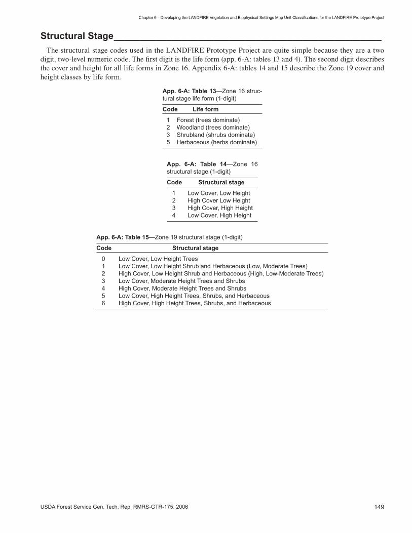
��9USDA Forest Service Gen. Tech. Rep. RMRS-GTR-�75. 2006
Chapter6—DevelopingtheLANDFIREVegetationandBiophysicalSettingsMapUnitClassificationsfortheLANDFIREPrototypeProject
Structural Stage ___________________________________________________ The structural stage codes used in the LANDFIRE Prototype Project are quite simple because they are a two digit, two-level numeric code. The first digit is the life form (app. 6-A: tables 13 and 4). The second digit describes the cover and height for all life forms in Zone 16. Appendix 6-A: tables 14 and 15 describe the Zone 19 cover and height classes by life form.
App. 6-A: Table 13—Zone �6 struc-tural stage life form (�-digit)
Code Life form
� Forest (trees dominate) 2 Woodland (trees dominate) � Shrubland (shrubs dominate) 5 Herbaceous (herbs dominate)
App. 6-A: Table 14—Zone �6 structural stage (�-digit)
Code Structural stage
� Low Cover, Low Height 2 High Cover Low Height � High Cover, High Height � Low Cover, High Height
App. 6-A: Table 15—Zone �9 structural stage (�-digit)
Code Structural stage
0 Low Cover, Low Height Trees � Low Cover, Low Height Shrub and Herbaceous (Low, Moderate Trees) 2 High Cover, Low Height Shrub and Herbaceous (High, Low-Moderate Trees) � Low Cover, Moderate Height Trees and Shrubs � High Cover, Moderate Height Trees and Shrubs 5 Low Cover, High Height Trees, Shrubs, and Herbaceous 6 High Cover, High Height Trees, Shrubs, and Herbaceous

�50 USDA Forest Service Gen. Tech. Rep. RMRS-GTR-�75. 2006
Chapter6—DevelopingtheLANDFIREVegetationandBiophysicalSettingsMapUnitClassificationsfortheLANDFIREPrototypeProject
App
endi
x 6-
B—
Cov
er ty
pes
for t
he w
este
rn U
.S.
____
____
____
____
____
____
____
____
____
____
____
_ C
T#
Cov
er ty
pe
Des
crip
tion
��0�
R
ipar
ian
Har
dwoo
da R
ipar
ian
hard
woo
d fo
rest
s in
the
wes
tern
U.S
. can
be
dom
inat
ed b
y m
any
spec
ies
of d
ecid
uous
tree
s, in
clud
ing
cot-
tonw
oods
(Pop
ulus
spp
.), w
hich
are
the
mos
t wid
e ra
ngin
g gr
oup.
Oth
er ri
paria
n ha
rdw
oods
incl
ude
gree
n as
h (F
raxi
-nu
s pe
nnsy
lvan
ica)
, and
Am
eric
an e
lm (U
lmus
am
eric
ana)
on
the
Gre
at P
lain
s; in
Cal
iforn
ia, C
alifo
rnia
syc
amor
e (P
. ra
cem
osa)
, and
Cal
iforn
ia w
alnu
t (Ju
glan
s ca
lifor
nica
); A
rizon
a sy
cam
ore
(Pla
tanu
s w
right
ii) in
the
sout
hwes
t; ne
tleaf
ha
ckbe
rry
(Cel
tis la
evig
ata
var.
retic
ulat
a) in
the
sout
hwes
t, in
term
ount
ain
wes
t and
Gre
at P
lain
s; a
nd w
hite
ald
er (A
lnus
rh
ombi
folia
) and
Ore
gon
ash
(Fra
xinu
s la
tifol
ia)inthePacificNorthwest.
��05
A
spen
-- B
ircha
Ext
ensi
ve a
reas
of u
plan
d fo
rest
s th
at o
ccur
in th
e W
est a
nd a
re d
omin
ated
by
trem
blin
g as
pen
(Pop
ulus
trem
uloi
des)
, th
e m
ost w
idel
y di
strib
uted
Nor
th A
mer
ican
tree
spe
cies
(Bur
ns a
nd H
onka
la �
990)
.
1406
PacificDeciduousForest
Purestandsdom
inatedbyspeciessuchasredalder(
Aln
us r
ubra
) and
big
leaf
map
le (A
cer
mac
roph
yllu
m) c
an o
ccur
[O
ther
Bro
adle
af]
in th
e N
orth
wes
t, w
ith re
d al
der r
angi
ng fr
om c
entra
l Cal
iforn
ia to
sou
thea
st A
lask
a, a
nd b
igle
af m
aple
ext
endi
ng o
nly
as fa
r nor
th a
s so
uthw
este
rn B
ritis
h C
olum
bia.
The
se s
peci
es c
an c
o-oc
cur a
nd a
re o
ften
foun
d in
mix
ture
s w
ith o
ther
co
nife
rs a
nd h
ardw
oods
(Min
ore
�979
; Har
ringt
on �
990;
Min
ore
and
Zasa
da �
990)
.
1101
PacificBroadleafEvergreenForest
StandsofCaliforniabay( U
mbe
llula
ria c
alifo
rnic
a) th
at a
re fo
und
in C
alifo
rnia
and
sou
thw
est O
rego
n (S
tein
�99
0) o
r
[Oth
er B
road
leaf
Eve
rgre
en]
stan
ds o
f tan
oak
( Lith
ocar
pus
dens
iflor
us) (
Tapp
eine
r, M
cDon
ald
et a
l. �9
90).
Bot
h sp
ecie
s co
mm
only
occ
ur in
mix
es
with
oth
er s
peci
es.
�50�
La
rch
Sta
nds
dom
inat
ed b
y w
este
rn la
rch
( Lar
ix o
ccid
enta
lis) o
ccur
in th
e no
rther
n R
ocki
es a
nd e
ast s
lope
s of
the
Cas
cade
s.
One
of t
wo
spec
ies
of d
ecid
uous
con
ifers
in th
e w
este
rn U
.S.,
wes
tern
larc
h is
mos
t com
mon
ly a
ssoc
iate
d w
ith D
oug-
las-fir,althoughitcangrowwithmanyotherspeciesofconifers(S
chmidtandShearer1990).
�20�
P
onde
rosa
Pin
ea S
tand
s do
min
ated
by
inte
rior p
onde
rosa
pin
e (P
inus
pon
dero
sa v
ar. s
copu
loru
m) a
re fo
und
in th
e in
terio
r Wes
t and
R
ocky
Mou
ntai
ns, a
nd A
rizon
a pi
ne (P
inus
pon
dero
sa v
ar. a
rizon
ica)
is fo
und
in th
e S
outh
wes
tern
U.S
.
1218
PacificPonderosaPine
Mixesofm
anyconiferousspeciescandom
inateforestsinmiddletolowerelevationsintheSierraNevadaRange,w
ith
Pacificponderosapine( P
inus
pon
dero
sa v
ar. p
acifi
ca) b
eing
“the
bio
logi
cal t
hrea
d th
at h
olds
the
phas
es o
f thi
s fo
rest
to
geth
er” (
Bar
bour
and
Min
nich
200
0). O
ther
spe
cies
that
can
dom
inat
e a
site
incl
ude
suga
r pin
e (P
inus
lam
bert
iana
), incense–cedar(
Cal
oced
rus
decu
rren
s), J
effre
y pi
ne (P
inus
jeffr
eyi),whitefir,andDouglas-fir(BarbourandMinnich
2000
).
�202
Fo
othi
ll P
ines
Th
e C
alifo
rnia
end
emic
s, C
oulte
r pin
e ( P
inus
cou
lteri)
, and
kno
bcon
e pi
ne (P
inus
atte
nuat
a) o
f Cal
iforn
ia a
nd O
rego
n ha
ve s
ome
or a
hig
h de
gree
of c
one
sero
tiny
in v
ario
us p
opul
atio
ns. W
here
they
occ
ur in
pur
e st
ands
, the
se s
peci
es
occu
py a
tran
sitio
n zo
ne b
etw
een
chap
arra
l and
con
ifero
us fo
rest
or w
oodl
and
at h
ighe
r ele
vatio
ns (H
owar
d �9
92; C
ope
�99�
).
�20�
W
este
rn W
hite
Pin
e S
eral
sta
nds
dom
inat
ed b
y w
este
rn w
hite
pin
e oc
cur i
n th
e no
rther
n R
ocki
es. I
t is
a m
inor
spe
cies
in o
ther
fore
st c
om-
munitiesinthisareaandoccursinmixedstandsinthePacificNorthwestandSierraNevadas(B
oyd1980).
�20�
Lo
dgep
ole
Pin
ea Lo
dgep
ole
pine
has
four
var
ietie
s, tw
o of
whi
ch a
re a
ssig
ned
to th
e lo
dgep
ole
pine
map
type
: Sie
rra
lodg
epol
e pi
ne
(Pin
us c
onto
rta
var.
mur
raya
na) a
nd R
ocky
Mou
ntai
n lo
dgep
ole
pine
(P. c
onto
rta
var.
latif
olia
). E
xten
sive
pur
e st
ands
occur,aswellasinassociationwithmanyotherspecies(LotanandCritchfield1990).

�5�USDA Forest Service Gen. Tech. Rep. RMRS-GTR-�75. 2006
Chapter6—DevelopingtheLANDFIREVegetationandBiophysicalSettingsMapUnitClassificationsfortheLANDFIREPrototypeProject
CT#
C
over
type
D
escr
iptio
n
1205
Douglas-fira
Douglas-fircanbeadominantinlargeareasofforestintheWest,occurringinpurestands,althoughfrequentlywitha
mixofm
anyotherspecies.B
othcoastD
ouglas-fir(
Pse
udot
suga
men
zies
ii va
r. m
enzi
esii)
and
Roc
ky M
ount
ain
Dou
g-las-fir( P
. m. v
ar. g
lauc
a)areincludedintheDouglas-fircovertype.
�206
G
rand
Fir
-- W
hite
Fira
Thistypeconsistsofstandsdominatedbygrandfir(A
bies
gra
ndis)orR
ockyMountainwhite-fir(
Abi
es c
onco
lor
var.
co
ncol
or),aspeciesandavarietyoftruefirthatoccurinsom
ewhatsimilarhabitatsintheInteriorW
est.
1207
PacificSilverFir--Noblefir
Standsdominatedbytheconifers,P
acificsilverfir(
Abi
es a
mab
ilis)ornoblefir(
Abi
es p
roce
ra),
indi
cate
a m
oist
coa
stal
siteinthePacificNorthwest.Thesespeciesoftenco-occurwithotherspeciesofconifers,m
ostconsistentlywestern
hem
lock
(Tsu
ga h
eter
ophy
lla),
and
mou
ntai
n he
mlo
ck (T
suga
mer
tens
iana
) (Fr
ankl
in �
980)
.
1219
RedFir
Redfir(
Abi
es m
agni
fica
and
A. m
agni
fica
var.
sha
sten
sis)
is a
clim
ax, h
igh
elev
atio
n sp
ecie
s th
at c
an o
ccur
in p
ure
stan
ds in
the
Sie
rra
Nev
adas
, sou
ther
n C
asca
des,
and
Coa
st R
ange
s, a
lthou
gh it
als
o in
terg
rade
s w
ith o
ther
con
ifers
(L
aack
e �9
90a)
.
1220
CaliforniaW
hiteFir
StandsofthistypeareindicatedbyCaliforniawhitefir(
Abi
es c
onco
lor
var.
low
iana
) and
occ
ur in
fore
sted
sta
nds
of
Cal
iforn
ia a
nd O
rego
n. It
com
mon
ly c
o-oc
curs
in m
ixtu
re w
ith o
ther
con
ifer s
peci
es ty
pica
l of d
rier s
ites
in th
e S
ierr
a,
Klamath,andSiskiyouMountains,suchasponderosapine,redfir,Jefferypine,sugarpineandDouglas-fir.Whitefiris
com
mon
ly a
late
r ser
al s
peci
es (L
aack
e �9
90b)
.
�209
W
este
rn H
emlo
ck
Pur
e or
mix
ed s
tand
s do
min
ated
by
wes
tern
hem
lock
( Tsu
ga h
eter
ophy
lla) o
ccur
in m
ild, h
umid
clim
atic
zon
es o
f the
PacificNorthwest,coastalAlaska,andthenorthernRockies.Itisamajororm
inorcom
ponentofatleast20differentfor -
est t
ypes
(Pac
kee
�990
).
1210
MountainHem
lock
Incold,snowy,highaltitudeforestsofthePacificNorthwest,coastalAlaska,theSierraNevadas,andthenorthern
Roc
ky M
ount
ains
, mou
ntai
n he
mlo
ck (T
suga
mer
tens
iana
) can
be
the
sole
dom
inan
t or m
ixed
with
oth
er h
igh
altit
ude
coni
fers
(Mea
ns �
990)
.
�2��
S
pruc
e --
Fira
InthewesternU.S.,thespruce-fircom
plexisahighelevationormontaneforestcom
munitydom
inatedbyEngelmann
spru
ce (P
icea
eng
elm
anni
i)and/orsubalpinefir(
Abi
es la
sioc
arpa
). O
ther
spe
cies
ass
igne
d to
this
com
plex
incl
ude
blue
sp
ruce
(Pic
ea p
unge
ns),
and
Bre
wer
’s s
pruc
e (P
icea
bre
wer
iana
), a
spec
ies
of th
e m
ount
ains
of n
orth
wes
t Cal
iforn
ia
and
sout
hwes
t Ore
gon
(Tho
rnbu
rgh
(�99
0b).
�2�2
S
itka
Spr
uce
Pur
e st
ands
of S
itka
spru
ce ( P
icea
sitc
hens
is)occurinanarrowbandalongthePacificcoast,fromcentralC
aliforniato
coas
tal A
lask
a (H
arris
�98
0), a
lthou
gh it
is o
ften
asso
ciat
ed w
ith w
este
rn h
emlo
ck ( T
suga
het
erop
hlla
).
�2��
C
edar
W
este
rn re
dced
ar ( T
huja
plic
ata)isthemostcom
monwesternspeciesinthisPacificNorthwesttype,com
monlyoc-
curringinmoistorw
etlocations,frequentlyinassociationwithothermoistsiteconifers(M
inore1990).Alaskacedar
(Cha
mae
cypa
ris n
ootk
aten
sis)candom
inatethecanopyinPacificNorthwestforests,althoughitoftenoccurswithmany
othe
r tre
e sp
ecie
s (H
arris
, �99
0.).
Por
t Orfo
rd c
edar
( Cha
mae
cypa
ris la
wso
nian
a) u
sual
ly o
ccur
s in
mix
ed s
tand
s in
a
smal
l are
a of
coa
stal
sou
thw
est O
rego
n an
d ad
jace
nt n
orth
ern
Cal
iforn
ia (Z
obel
�99
0).
App
endi
x 6-
B—
(Con
tinue
d)

�52 USDA Forest Service Gen. Tech. Rep. RMRS-GTR-�75. 2006
Chapter6—DevelopingtheLANDFIREVegetationandBiophysicalSettingsMapUnitClassificationsfortheLANDFIREPrototypeProject
CT#
C
over
type
D
escr
iptio
n
�2�5
R
edw
ood
Fore
sted
sta
nds
dom
inat
ed b
y re
dwoo
d (S
equo
ia s
empe
rvire
ns) a
re fo
und
in n
orth
ern
Cal
iforn
ia a
nd e
xtre
me
sout
h-w
este
rn O
rego
n, o
ccur
ring
in p
ure
stan
ds a
nd in
mix
ture
s w
ith o
ther
spe
cies
.
1216
Sequoia
Giantsequoia( S
equo
iade
ndro
n gi
gant
eum
) occ
urs
in a
ver
y lim
ited
dist
ribut
ion
in th
e ce
ntra
l and
sou
ther
n S
ierr
a N
e-va
da M
ount
ains
whe
re it
dom
inat
es s
tand
s w
here
oth
er c
onife
rous
spe
cies
are
com
mon
ly p
rese
nt.
�2�7
C
ypre
ss
The
cypr
ess
cove
r typ
e co
nsis
ts o
f sta
nds
dom
inat
ed b
y on
e of
thre
e sp
ecie
s of
cyp
ress
, gen
eral
ly s
mal
l tre
es w
ith
sero
tinou
s co
nes.
Ariz
ona
cypr
ess
(Cup
ress
us a
rizon
ica)
(Sul
livan
�99
�) s
omet
imes
occ
urs
in p
ure
stan
ds o
r mix
ed
with
oth
er s
peci
es in
ripa
rian
and
som
e up
land
hab
itats
of t
he s
outh
wes
t. M
acN
ab’s
cyp
ress
(Cup
ress
us m
acna
bian
a)
(Ess
er �
99�a
) and
Sar
gent
’s c
ypre
ss ( C
upre
ssus
sar
gent
ii) b
oth
occu
r in
Cal
iforn
ia (E
sser
�99
�b),
occu
rrin
g in
pur
e st
ands
or m
ixed
with
at l
east
one
oth
er c
onife
r spe
cies
.
�80�
Ti
mbe
rline
Pin
esa
This
type
con
sist
s of
spe
cies
of p
ines
dom
inat
ing
fore
sts
and
woo
dlan
ds a
t upp
er a
nd lo
wer
tim
berli
nes,
incl
udin
g th
e hi
gh e
leva
tion
spec
ies
foxt
ail p
ine
(Pin
us b
alfo
uria
na) o
f Cal
iforn
ia, b
ristle
cone
pin
e (P
inus
aris
tata
), G
reat
Bas
in b
ristle
-co
ne p
ine
(Pin
us lo
ngae
va),
whi
teba
rk p
ine
(Pin
us a
lbic
aulis
) and
lim
ber p
ine
(Pin
us fl
exili
s), a
spe
cies
that
can
app
ear
at b
oth
uppe
r and
low
er ti
mbe
rline
. Alp
ine
larc
h (L
arix
lyal
lii),
a de
cidu
ous
coni
fer,
is a
lso
incl
uded
bec
ause
it m
ixes
with
so
me
of th
ese
spec
ies
in th
e no
rther
n R
ocki
es.
2�0�
D
ecid
uous
Oak
Th
ese
woo
dlan
ds a
re o
pen
stan
ds d
omin
ated
by
a sp
ecie
s of
dec
iduo
us o
ak, i
nclu
ding
the
Cal
iforn
ia e
ndem
ics,
blu
e oa
k (Q
uerc
us d
ougl
asii)
or C
alifo
rnia
whi
te o
ak (Q
uerc
us lo
bata
) (H
owar
d �9
92b)
. The
se s
peci
es c
o-oc
cur a
t low
er e
l-ev
atio
ns (M
cDon
ald
�990
b) O
ther
spe
cies
of d
ecid
uous
oak
that
may
eac
h do
min
ate
fore
st o
r woo
dlan
d st
ands
incl
ude
bur o
ak (Q
uerc
us m
acro
carp
a) in
the
north
ern
plai
ns (J
ohns
on �
990)
; Cal
iforn
ia b
lack
oak
(Que
rcus
kel
logg
ii), e
ndem
ic
to C
alifo
rnia
(McD
onal
d �9
90a)
; and
Ore
gon
whi
te o
ak ( Q
uerc
us g
arry
ana)
, whi
ch ra
nges
from
sou
thw
este
rn B
ritis
h C
olum
bia
to c
entra
l Cal
iforn
ia (S
tein
�99
0a).
2�0�
E
verg
reen
Oak
E
verg
reen
oak
woo
dlan
ds a
re o
pen
stan
ds o
f gen
eral
ly s
mal
l sta
ture
tree
s, o
ccur
ring
in th
e so
uthw
est a
nd in
Cal
iforn
ia.
Coa
st li
ve o
ak (Q
uerc
us a
grifo
lia),
Eng
elm
ann’
s oa
k (Q
uerc
us e
ngel
man
nii),
and
inte
rior l
ive
oak
(Que
rcus
wis
lizen
ii)
are
com
mon
Cal
iforn
ia w
oodl
and
spec
ies
(Fin
ch a
nd M
cCle
ery
�990
; Tirm
enst
ein
�989
). C
anyo
n liv
e oa
k ( Q
uerc
us
chry
sole
pis)
is a
spe
cies
of e
verg
reen
-leav
ed o
ak th
at d
omin
ates
fore
st a
nd w
oodl
and
stan
ds in
Ore
gon,
Cal
iforn
ia, a
nd
Ariz
ona
(Tho
rnbu
rgh
�990
a). I
n th
e S
outh
wes
t, th
ese
woo
dlan
ds m
ay b
e do
min
ated
by
Em
ory
oak
( Que
rcus
em
oryi
) (P
avek
�99
�a),
gray
oak
( Que
rcus
gris
ea) (
Pav
ek �
99�b
), M
exic
an b
lue
oak
(Que
rcus
olo
ngifo
lia) (
Pav
ek �
99�)
, or
Ariz
ona
whi
te o
ak (Q
uerc
us a
rizon
ica)
(Pav
ek �
99�c
). S
ome
of th
ese
sout
hwes
tern
woo
dlan
d sp
ecie
s ca
n co
-occ
ur, a
s w
ell a
s gr
ow w
ith c
onife
rs (P
avek
�99
�).
220�
P
inyo
n --
Jun
iper
a Th
e pi
nyon
-juni
per t
ype
cont
ains
ope
n st
ands
dom
inat
ed b
y a
spec
ies
of tr
ee-li
ke ju
nipe
r and
a s
peci
es o
f pin
yon
pine
, w
ith th
e pi
nyon
at l
east
20%
of t
he to
tal t
ree
cove
r. Ju
nipe
r spe
cies
incl
ude
allig
ator
juni
per (
Juni
peru
s de
ppea
na),
Cal
iforn
ia ju
nipe
r (J.
cal
iforn
ica)
, one
seed
juni
per (
J. m
onos
perm
a), P
inch
ot’s
juni
per (
J. p
inch
ottii
), re
dber
ry ju
nipe
r (J.
co
ahui
lens
is),
Roc
ky M
ount
ain
juni
per (
J. s
copu
loru
m),
Uta
h ju
nipe
r (J.
ost
eosp
erm
a), a
nd w
este
rn ju
nipe
r (J.
occ
i-de
ntal
is).
Pin
yon
spec
ies
can
incl
ude
sing
lele
af p
inyo
n (P
inus
mon
ophy
lla),
two-
need
le p
inyo
n (P
inus
edu
lis),
Mex
ican
pi
nyon
(Pin
us c
embr
oide
s), p
aper
shel
l pin
yon
(Pin
us r
emot
a/ce
mbr
oide
s), a
nd P
arry
pin
yon
(Pin
us q
uadr
ifolia
).
2202
Ju
nipe
ra O
pen
stan
ds d
omin
ated
by
juni
per,
with
pin
yon
less
than
20%
of t
he to
tal t
ree
cove
r, or
abs
ent.
Juni
per s
peci
es a
re
thos
e lis
ted
for p
inyo
n-ju
nipe
r.
App
endi
x 6-
B—
(Con
tinue
d)

�5�USDA Forest Service Gen. Tech. Rep. RMRS-GTR-�75. 2006
Chapter6—DevelopingtheLANDFIREVegetationandBiophysicalSettingsMapUnitClassificationsfortheLANDFIREPrototypeProject
CT#
C
over
type
D
escr
iptio
n
�70�
M
ount
ain
Dec
iduo
us S
hrub
a Th
ese
asso
ciat
ions
of m
ediu
m to
tall
deci
duou
s sh
rubs
are
usu
ally
in m
esic
upl
and
site
s, g
ener
ally
at l
ower
ele
vatio
ns
than
con
tinuo
us fo
rest
. In
the
east
ern
Gre
at B
asin
, spe
cies
can
incl
ude
serv
iceb
erry
(Am
elan
chie
r ut
ahen
sis)
, gam
bel
oak
(Que
rcus
gam
belii
), ch
okec
herr
y (P
runu
s vi
rgin
iana
), an
d sn
owbe
rry
(Sym
phor
icar
pos
oreo
philu
s).
��02
R
ipar
ian
Shr
uba
Rip
aria
n zo
nes
dom
inat
ed b
y ta
ll an
d m
ediu
m s
ized
shr
ubs,
with
one
to s
ever
al s
peci
es o
f will
ows,
occ
ur th
roug
hout
the
Wes
t. In
the
Inte
rmou
ntai
n W
est,
ripar
ian
will
ows
incl
ude
Beb
b w
illow
(Sal
ix b
ebbi
ana)
, Boo
th w
illow
(S. b
ooth
ii), D
rum
-m
ond
will
ow (S
. dru
mm
ondi
ana)
, coy
ote
will
ow (S
. exi
gua)
, Gey
er w
illow
(S. g
eyer
iana
), an
d ye
llow
will
ow (S
. lut
ea)
(Wel
sh e
t. al
. �98
7). T
hinl
eaf a
lder
( Aln
us in
cana
), w
ater
birc
h (B
etul
a oc
cide
ntal
is),
and
gold
en c
urra
nt (R
ibes
aur
eum
) ar
e al
so c
omm
on in
ripa
rian
zone
s.
��0�
E
xotic
Rip
aria
n S
hrub
a R
ipar
ian
com
mun
ities
can
be
dom
inat
ed b
y pu
re o
r hyb
rid s
peci
es o
f tam
aris
k (T
amar
ix s
pp.),
a c
ompl
ex o
f hyb
ridiz
ing
exot
ic s
peci
es.
��0�
M
ount
ain
Big
Sag
ebru
sh C
ompl
exa
Com
mon
thro
ugho
ut th
e In
term
ount
ain
Wes
t, th
is c
ompl
ex is
usu
ally
dom
inat
ed b
y m
ount
ain
big
sage
brus
h (A
rtem
isia
tr
iden
tata
ssp
. vas
eyan
a).O
thershrubsofsimilarecologicalrequirementsthatindicatethiscom
plexincludemountain
silv
er s
ageb
rush
(Art
emis
ia c
ana
ssp.
vis
cidu
la),snow
fieldsagebrush(A
rtem
isia
trid
enta
ta s
sp. s
pici
form
is),
A. t
riden
-ta
ta v
ar. p
auci
flora
, Rot
hroc
ks’s
arte
mis
ia (A
. rot
hroc
kii),
and
tall
thre
etip
sag
ebru
sh (A
. trip
artit
a ss
p. tr
ipar
tita)
(Tar
t 20
0�).
Occ
urrin
g at
hig
her e
leva
tions
and
mor
e m
esic
con
ditio
ns th
an th
e ot
her b
ig s
ageb
rush
sub
spec
ies,
it is
usu
ally
ch
arac
teriz
ed b
y th
e pr
esen
ce o
f a m
oder
atel
y pr
oduc
tive
herb
aceo
us u
nder
stor
y of
bot
h gr
asse
s an
d fo
rbs.
No
parti
cu-
lar h
erba
ceou
s sp
ecie
s ar
e co
nsis
tent
ly fo
und
in th
is c
ompl
ex.
��02
W
yom
ing
-- B
asin
Big
Sag
ebru
sh
Occurringatlowerelevationanddriersitesthanmountainbigsagebrush,thiscom
plexisusuallyidentifiedbythepre
C
ompl
exa
ence
of W
yom
ing
big
sage
brus
h (A
rtem
isia
trid
enta
ta s
sp. w
yom
inge
nsis
), or
bas
in b
ig s
ageb
rush
(A. t
riden
tata
ssp
. tr
iden
tata
). O
ther
shr
ubs
that
indi
cate
this
com
plex
incl
ude
plai
ns s
ilver
sag
ebru
sh (A
. can
a ss
p. c
ana)
, Bol
ande
r silv
er
sage
brus
h (A
. can
a ss
p. b
olan
deri)
, and
Art
emis
ia tr
iden
tata
ssp
. xer
icen
sis
(Tar
t 200
�). T
he h
erba
ceou
s un
ders
tory
is
less
pro
duct
ive
than
on
mou
ntai
n bi
g sa
gebr
ush
site
s. N
o he
rbac
eous
spe
cies
is k
now
n co
nsis
tent
ly o
ccur
in th
is c
om-
plex
.
��0�
D
war
f Sag
ebru
sh C
ompl
exa
Com
mun
ities
dom
inat
ed b
y an
y of
a g
roup
of s
mal
l sag
ebru
sh s
peci
es, u
sual
ly w
ith a
spa
rse
unde
rsto
ry. S
peci
es c
an
incl
ude
blac
k sa
gebr
ush
(Art
emis
ia n
ova)
, Rig
id (s
tiff)
sage
brus
h (A
. rig
ida)
, Wyo
min
g th
reet
ip s
ageb
rush
(A. t
ripar
tita
ssp.
rup
icol
a), b
irdfo
ot s
ageb
rush
(A.p
edat
ifida
), an
d th
ree
subs
peci
es o
f low
sag
ebru
sh (A
. arb
uscu
la s
sp. l
ongi
loba
, A.
a. s
sp. t
herm
opop
ola
and
A. t
. ssp
. arb
uscu
la).
��0�
S
and
Sag
ebru
sha
A sh
rub
com
mun
ity c
omm
on o
n th
e G
reat
Pla
ins
is th
at d
omin
ated
by
sand
sag
ebru
sh (A
rtem
isa
filifo
lia).
��05
B
lack
brus
ha Th
is d
eser
t shr
ub c
omm
unity
com
mon
in th
e ar
id S
outh
wes
t is
dom
inat
ed b
y al
mos
t pur
e st
ands
of b
lack
brus
h (C
oleo
-gy
ne r
amos
issi
ma)
.
��06
R
abbi
tbru
sha
Sem
i-arid
to a
rid s
hrub
com
mun
ities
are
foun
d in
the
Inte
rmou
ntai
n W
est t
hat a
re d
omin
ated
by
any
of s
ever
al s
peci
es
of ra
bbitb
rush
, inc
ludi
ng ru
bber
rabb
itbru
sh (E
ricam
eria
nau
seos
a), G
reen
e ra
bbitb
rush
(Chr
ysot
ham
nus
gree
nei),
and
st
icky
leaf
rabb
itbru
sh (C
hrys
otha
mnu
s vi
scid
iflor
us).
App
endi
x 6-
B—
(Con
tinue
d)

�5� USDA Forest Service Gen. Tech. Rep. RMRS-GTR-�75. 2006
Chapter6—DevelopingtheLANDFIREVegetationandBiophysicalSettingsMapUnitClassificationsfortheLANDFIREPrototypeProject
CT#
C
over
type
D
escr
iptio
n
��07
C
hapa
rral
a Chaparralcom
munitieshavemoderatetodensecoveroftall,stifflybranchedevergreen-leavedshrubs,som
etimes
dom
inat
ed b
y ch
amis
e (A
deno
stom
a fa
scic
ulat
um),
and
ofte
n co
mpo
sed
of a
mix
of m
any
shru
b sp
ecie
s. O
ther
co
mm
on c
hapa
rral
spe
cies
incl
ude:
hoa
ryle
af c
eano
thus
(Cea
noth
us c
rass
ifoliu
s), b
uckb
rush
(C. c
unea
tus)
, cup
leaf
ce
anot
hus
(C. g
regg
ii), h
airy
cea
noth
us (C
. olig
anth
us),
whi
teth
orn
cean
othu
s (C
eano
thus
cor
dula
tus)
, big
berr
y m
anza
-ni
ta (A
rcto
stap
hylo
s gl
auca
), E
astw
ood
man
zani
ta (A
. gla
ndul
osa)
, poi
ntle
af m
anza
nita
(A. p
atul
a), N
utta
ll’s s
crub
oak
(Q
uerc
us d
umos
a), a
nd tu
rbin
ella
oak
(Q. t
urbi
nella
). Th
is ty
pe o
ccur
s in
occ
urs
in C
alifo
rnia
, Ariz
ona,
and
sou
ther
n U
tah.
��08
S
oft C
hapa
rral
Th
is is
a c
oast
al s
hrub
com
mun
ity o
f cen
tral a
nd s
outh
ern
Cal
iforn
ia, o
ccur
ring
on d
ry, s
omet
imes
rock
y sl
opes
, dom
i -na
ted
by a
mix
of s
peci
es w
ith s
oft,
plia
ble
leav
es. D
iagn
ostic
spe
cies
incl
ude
blac
k sa
ge (S
alvi
a m
ellif
era)
, pur
ple
sage
(S
alvi
a le
ucop
hylla
), w
hite
sag
e (S
alvi
a ap
iana
), an
d co
asta
l sag
ebru
sh (A
rtem
isia
cal
iforn
ica)
.
��0�
O
ther
Eve
rgre
en S
hrub
sa Th
ese
are
char
acte
ristic
, upl
and,
mes
ic s
ite s
hrub
com
mun
ities
dom
inat
ed b
y ev
ergr
een-
leav
ed s
hrub
s, s
uch
as c
urle
af
mou
ntai
n-m
ahog
any
(Cer
coca
rpus
ledi
foliu
s), l
ittle
leaf
mou
ntai
n-m
ahog
any
(Cer
coca
rpus
intr
icat
us),
or s
now
brus
h (C
eano
thus
vel
utin
us).
�70�
S
alt D
eser
t Shr
uba
This
cov
er ty
pe c
onsi
sts
of a
rid s
hrub
com
mun
ities
that
occ
ur th
roug
hout
the
Wes
t and
are
dom
inat
ed b
y m
ixes
of
halo
phyt
ic (s
alt t
oler
ant)
shru
b sp
ecie
s, s
uch
as s
hads
cale
(Atr
iple
x co
nfer
tifol
ia),
iodi
ne b
ush
(Alle
nrol
fea
occi
dent
alis
), bl
ack
grea
sew
ood
(Sar
coba
tus
verm
icul
atus
) and
win
terfa
t (K
rasc
heni
nnik
ovia
lana
ta) (
Wes
t and
You
ng 2
000)
.
�702
D
eser
t Shr
uba
Des
ert s
hrub
com
mun
ities
occ
ur in
arid
land
s of
the
Sou
thw
est,
incl
udin
g th
e S
onor
an a
nd M
ojav
e D
eser
ts, o
ften
with
a
spar
se h
erba
ceou
s un
ders
tory
. Cre
osot
ebus
h (L
arre
a tr
iden
tata),andfrequentlybursage(A
mbr
osia
dum
osa)
, ofte
n do
min
ate,
alth
ough
man
y ot
her s
hrub
spe
cies
can
be
the
dom
inan
t. O
ther
spe
cies
incl
ude
tarb
ush
(Flo
uren
sia
cern
ua),
palo
verd
e (C
erci
dium
spp
.), c
atcl
aw a
caci
a (A
caci
a gr
eggi
i), a
nd s
mok
e tre
e (D
alea
spi
nosa
).
�70�
D
ry D
ecid
uous
Shr
uba
Dry
site
s in
the
Inte
rmou
ntai
n W
est t
hat c
an s
uppo
rt a
plan
t com
mun
ity d
omin
ated
by
deci
duou
s le
aved
shr
ubs,
incl
ud-
ing
bitte
rbru
sh (P
ursh
ia tr
iden
tata
), U
tah
serv
iceb
erry
(Am
elan
chie
r ut
ahen
sis)
, and
true
mou
ntai
n m
ahog
any
(Cer
co-
carp
us m
onta
nus)
.
��0�
W
arm
Sea
son
Gra
sses
a
Thes
e ar
e co
mm
uniti
es o
f gra
sses
that
gro
w d
urin
g la
te s
prin
g an
d su
mm
er in
clim
ates
whe
re m
oist
ure
is n
ot li
miti
ng a
t th
at ti
me
of th
e ye
ar a
nd re
mai
n gr
een
durin
g th
e ho
ttest
par
t of t
he s
umm
er (C
-� g
rass
es).
��02
C
ool S
easo
n G
rass
es a
Th
ese
plan
t com
mun
ities
are
dom
inat
ed b
y sp
ecie
s of
gra
sses
that
gro
w b
est d
urin
g co
ol a
nd m
oist
per
iods
of t
he y
ear.
They
gre
en u
p ea
rly in
the
grow
ing
seas
on, c
ure
durin
g th
e he
at o
f the
sum
mer
, and
can
gre
en u
p in
the
fall,
dep
endi
ng
on s
peci
es c
hara
cter
istic
s an
d w
eath
er (C
-� g
rass
es).
�20�
N
ativ
e Fo
rbsa
Thes
e pl
ant c
omm
uniti
es c
an b
e do
min
ated
by
a hi
gh d
iver
sity
of p
eren
nial
forb
spe
cies
, usu
ally
occ
urrin
g on
mes
ic to
m
oist
site
s in
the
mou
ntai
ns. M
any
diffe
rent
forb
spe
cies
can
indi
cate
this
type
incl
udin
g m
ount
ain
blue
bell
(Mer
tens
iana
ci
liata
), no
rther
n m
ule’
s-ea
r (W
yeth
ia a
mpl
exic
aulis
), ne
ttlel
eaf g
iant
-hys
sop
(Aga
stac
he u
rtic
ifolia
), fe
rnle
af w
ild lo
vage
(L
igus
ticum
filic
inum
), S
itka
vale
rian
(Val
eria
na s
itche
nsis
), an
d A
rctic
lupi
ne (L
upin
us a
rctic
us s
sp. s
ubal
pinu
s) (N
atur
e-se
rve
200�
).
�202
E
xotic
For
bsa
Com
mun
ities
of e
xotic
forb
s th
at c
an b
e do
min
ated
by
wee
dy s
peci
es s
uch
as s
potte
d kn
apw
eed
(Cen
taur
ea m
acu-
losa
), le
afy
spur
ge (E
upho
rbia
esu
la),
or S
t. Jo
hn’s
wor
t (H
yper
icum
per
fora
tum
).
App
endi
x 6-
B—
(Con
tinue
d)

�55USDA Forest Service Gen. Tech. Rep. RMRS-GTR-�75. 2006
Chapter6—DevelopingtheLANDFIREVegetationandBiophysicalSettingsMapUnitClassificationsfortheLANDFIREPrototypeProject
��0�
W
etla
nd H
erba
ceou
sa R
ipar
ian,
wet
mea
dow
s, a
nd s
eep
com
mun
ities
are
dom
inat
ed b
y gr
amin
oids
and
forb
s an
d us
ually
hav
e so
ils th
at a
re
satu
rate
d fo
r at l
east
par
t of t
he g
row
ing
seas
on. C
omm
on s
peci
es o
f the
se c
omm
uniti
es in
clud
e se
dges
(e.g
. Car
ex
aqua
tilis
, C. n
ebra
scen
sis
and
C. r
ostr
ata)
, alk
ali c
ordg
rass
(Spa
rtin
a gr
acili
s), m
arsh
spi
keru
sh (E
leoc
haris
pal
ustr
is),
andforbssuchasprimrosemonkey-flower( M
imul
us p
rimul
oide
s) a
nd w
hite
mar
sh-m
arig
old
(Cal
tha
lept
osep
ala)
(Na-
ture
serv
e 20
0�).
Whe
ther
a c
omm
unity
is c
onsi
dere
d rip
aria
n, w
et m
eado
w, o
r see
p de
pend
s on
the
sour
ce o
f its
wat
er.
��02
A
lpin
ea Th
ese
plan
t com
mun
ities
occ
ur a
bove
upp
er tr
eelin
e an
d ar
e do
min
ated
by
herb
aceo
us s
peci
es, u
sual
ly m
ixes
of
sedg
es, g
rass
es, a
nd p
eren
nial
forb
s. In
dica
tor f
orbs
incl
ude
Ros
s’ a
vens
(Geu
m r
ossi
i), w
hite
coi
l-bea
k lo
usew
ort
(Ped
icul
aris
con
tort
a), s
prea
ding
phl
ox (P
hlox
diff
usa)
, Col
orad
o bl
ue c
olum
bine
(Aqu
ilegi
a ca
erul
ea),
and
gram
inoi
ds
incl
ude
shor
thai
r ree
dgra
ss (C
alam
agro
stis
bre
wer
i), a
nd D
rum
mon
d’s
rush
(Jun
cus
drum
mon
dii)
(Nat
ures
erve
200
�).
��0�
A
nnua
l Gra
ssla
ndsa
A
ny e
xten
sive
are
a of
ann
ual g
rass
land
s in
the
wes
tern
U.S
. tha
t are
dom
inat
ed b
y ex
otic
spe
cies
, inc
ludi
ng
chea
tgra
ss (B
rom
us te
ctor
um),
and
med
usah
ead
(Tae
niae
ther
um c
aput
-med
usae
).a IndicatestypewasrefinedwithZone16plotdata.
Bar
bour
, M. G
. and
R. A
. Min
nich
(200
0). C
alifo
rnia
n U
plan
d Fo
rest
s an
d W
oodl
ands
. Nor
th A
mer
ican
Ter
rest
rial V
eget
atio
n. C
ambr
idge
, UK
, Cam
brid
ge U
nive
rsity
Pre
ss.
Bur
ns, R
. M. a
nd B
. H. H
onka
la (�
990)
. Silv
ics
of N
orth
Am
eric
a. V
olum
e �:
Con
ifers
. Was
hing
ton
DC
, US
DA
Fore
st S
ervi
ce: 6
75.
Cop
e, A
. B. (
�99�
). P
inus
cou
lteri.
Fire
Effe
cts
Info
rmat
ion
Sys
tem
[Onl
ine]
, US
DA
Fore
st S
ervi
ce, R
ocky
Mou
ntai
n R
esea
rch
Sta
tion,
Fire
Sci
ence
s La
bora
tory
(Pro
duce
r). 2
005.
Har
ringt
on, C
. A. (
�990
). S
ilvic
s of
red
alde
r. S
ilvic
s of
Nor
th A
mer
ica.
Vol
ume
2: H
ardw
oods
. R. M
. Bur
ns a
nd B
. H. H
. t. c
oord
inat
ors)
. Was
hing
ton
D.C
., U
SD
A Fo
rest
Ser
vice
: ��6
-�2�
.
How
ard,
J. L
. (�9
92).
Pin
us a
ttenu
ata.
Fire
Effe
cts
Info
rmat
ion
Sys
tem
[Onl
ine]
, US
DA
Fore
st S
ervi
ce, R
ocky
Mou
ntai
n R
esea
rch
Sta
tion,
Fire
Sci
ence
s La
bora
tory
(Pro
duce
r). 2
005.
Lotan,J.E
.andW
.B.C
ritchfield(1
990).P
inus
con
tort
a ss
p. m
urra
yana
- lo
dgep
ole
pine
fore
st. S
ilvic
s of
Nor
th A
mer
ican
. Vol
ume
�: C
onife
rs. R
. M. B
runs
and
B. H
. H. t
. coo
rdin
ator
s). W
ash-
ingt
on D
.C.,
US
DA
Fore
st S
ervi
ce: �
02-�
��.
Minore,D.(1979).Com
parativeautecologicalcharacteristicsofnorthwesterntreespecies:aliteraturereview
.Portland,O
R.,USA,U
.S.D
epartmentofAgriculture,ForestService,PacificNorthwest
Fore
st a
nd R
ange
Exp
erim
ent S
tatio
n: 2
8.
Min
ore,
D. a
nd J
. C. Z
asad
a (�
990)
. Ace
r m
acro
phyl
lum
Pur
sh --
Big
leaf
map
le. S
ilvic
s of
Nor
th A
mer
ica.
Vol
ume
2: H
ardw
oods
. R. M
. Bur
ns a
nd B
. H. H
. t. c
oord
inat
ors)
. Was
hing
ton
D.C
., U
SD
A Fo
rest
Ser
vice
: ��-
�0.
Sch
mid
t, W
. C. a
nd R
. C. S
hear
er (�
990)
. Lar
ix o
ccid
enta
lis N
utt -
- Wes
tern
larc
h. S
ilvic
s of
Nor
th A
mer
ica.
Vol
ume
�: C
onife
rs. R
. M. B
urns
and
H. B
. H. t
. coo
rdin
ator
s). W
ashi
nnto
n D
.C.,
US
DA
Fore
st S
ervi
ce: �
60-�
72.
Ste
in, W
. I. (
�990
). U
mbe
llula
ria c
alifo
rnic
a (H
ook.
& A
rn.)
Nut
t., C
alifo
rnia
-laur
el. S
ilvic
s of
Nor
th A
mer
ica.
Vol
ume
2: H
ardw
oods
. R. M
. Bur
ns a
nd B
. H. H
. t. c
oord
inat
ors)
. Was
hing
ton
D.C
., U
SD
A Fo
rest
Ser
vice
: 826
-8��
.
Tappeiner,J.C.,P.M.M
cDonald,etal.(1990).Lithocarpusdendiflorus(H
ook.&Arn.)Rehd.S
ilvic
s of
Nor
th A
mer
ica.
Vol
ume
2: H
ardw
oods
. R. M
. Bur
ns a
nd B
. H. H
. t. c
oord
inat
ors)
. Was
hing
-to
m D
.C.,
US
DA
Fore
st S
ervi
ce: �
�7-�
25.
Tart,
D. (
200�
). R
egio
nal E
colo
gist
, US
DA
Fore
st S
ervi
ce, I
nter
mou
ntai
n R
egio
n: T
he s
hrub
spe
cies
ass
ocia
ted
with
eac
h of
the
thre
e sa
gebr
ush
com
plex
es d
escr
ibed
as
zone
�6
cove
r typ
es
are
thos
e as
sign
ed to
thes
e gr
oups
dur
ing
the
crea
tion
of th
e m
ap o
f sag
ebru
sh la
nd c
over
type
s in
Sag
ebru
sh m
appi
ng, B
road
scal
e st
itch
proj
ect.
Pre
pare
d by
Nat
ureS
erve
and
The
N
atur
e C
onse
rvan
cy. F
ebru
ary
2002
.
CT#
C
over
type
D
escr
iptio
n
App
endi
x 6-
B—
(Con
tinue
d)

�56 USDA Forest Service Gen. Tech. Rep. RMRS-GTR-�75. 2006
Chapter6—DevelopingtheLANDFIREVegetationandBiophysicalSettingsMapUnitClassificationsfortheLANDFIREPrototypeProject
App
endi
x 6-
C—
Cro
ssw
alk
of w
este
rn L
AN
DFI
RE
cove
r typ
es to
Gap
Ana
lysi
s Pr
ogra
m (G
AP)
, Soc
iety
of
Am
eric
an F
ores
ters
(SA
F), a
nd S
ocie
ty fo
r Ran
ge M
anag
emen
t (SR
M) c
over
type
s (E
yre
1980
, M
erch
ant a
nd o
ther
s 19
98, S
hifle
t 199
4) _
____
____
____
____
____
____
____
____
____
____
____
____
____
(Wes
tern
U.S
.) C
T#
LAN
DFI
RE
cove
r typ
e G
AP
cove
r typ
e SR
M#
SRM
cov
er ty
pe
SAF#
SA
F co
ver t
ype
��0�
R
ipar
ian
Har
dwoo
d M
aple
20
� R
ipar
ian
Woo
dlan
d 22
2 B
lack
Cot
tonw
ood-
Will
ow
2�5
Cot
tonw
ood-
Will
ow��
05
Asp
en --
Birc
h A
spen
2�
7 A
spen
Asp
en -
Con
ifer
�8
Pap
er B
irch
1406
PacificDeciduousForest
[O
ther
Bro
adle
af]
22
� R
ed A
lder
1101
PacificBroadleaf
CaliforniaBay
E
verg
reen
For
est [
Oth
er
Bro
adle
af E
verg
reen
]1501
Larch
WesternLarch-Douglas-fir
109
PonderosaPine-Shrubland
212
WesternLarch
�20�
P
onde
rosa
Pin
e P
onde
rosa
Pin
e
2�
7 In
terio
r Pon
dero
sa P
ine
Pon
dero
sa P
ine/
Shr
ub
P
onde
rosa
Pin
e/O
ak -
Juni
per-
Pin
yon
Pon
dero
sa P
ine
- Lod
gepo
le P
ine
Inte
rior P
onde
rosa
Pin
e
PacificPonderosaPine
JeffreyPine
247
JeffreyPine
CaliforniaFoothillPine
245
PacificPonderosaPine
MixedSugarPine
244
PacificPonderosaPine-Douglas-fir
2�
� S
ierr
a M
ixed
Con
ifer
�202
Fo
othi
ll P
ine
Cal
iforn
ia F
ooth
ill P
ine
2�8
Kno
bcon
e P
ine
Kno
bcon
e P
ine
Mon
tere
y P
ine
�20�
W
este
rn W
hite
Pin
e W
este
rn W
hite
Pin
e
2�
5 W
este
rn W
hite
Pin
e�2
0�
Lodg
epol
e P
ine
Lodg
epol
e P
ine
2�8
Lodg
epol
e P
ine
LodgepolePine-D
ouglas-fir
Coa
stal
Lod
gepo
le P
ine
Sie
rra
Lodg
epol
e P
ine
1205
Douglas-fir
InlandDouglas-fir
210
InteriorD
ouglas-fir
InlandDouglas-fir-W
esternRedCedar
230
Douglas-fir-WesternHem
lock
Douglas-fir-PonderosaPine-IncenseCedar
229
PacificDouglas-fir
WestsideDouglas-fir-W
esternHem
lock
234
Douglas-fir-Tanoak-PacificMadrone
WestsideDouglas-fir
Douglas-fir-Tanoak-P
acificMadrone
Douglas-fir-SugarPine-P
onderosaPine
Douglas-fir-W
hiteFir-B
lueSpruce
1206
GrandFir--W
hiteFir
GrandFir-D
ouglas-fir
213
GrandFir
WhiteFir-D
ouglas-fir
210
InteriorD
ouglas-fir
Whi
te F
ir
WhiteFir-D
ouglas-fir/S
hrub

�57USDA Forest Service Gen. Tech. Rep. RMRS-GTR-�75. 2006
Chapter6—DevelopingtheLANDFIREVegetationandBiophysicalSettingsMapUnitClassificationsfortheLANDFIREPrototypeProject
(W
este
rn U
.S.)
CT#
LA
ND
FIR
E co
ver t
ype
GA
P co
ver t
ype
SRM
# SR
M c
over
type
SA
F#
SAF
cove
r typ
e
1207
PacificSilverFir–NobleFir
PacificSilverFir
226
CoastalTrueFir-Hem
lock
�2�9
R
ed F
ir R
ed F
ir
20
7 R
ed F
ir�2
20
Cal
iforn
ia W
hite
Fir
2�
� W
hite
Fir
�209
W
este
rn H
emlo
ck
Wes
tsid
e W
este
rn H
emlo
ck -
22
� W
este
rn H
emlo
ck
W
este
rn R
ed C
edar
22
5 W
este
rn H
emlo
ck-S
itka
Spr
uce
Inla
nd W
este
rn R
ed H
emlo
ck
�2
�0
Mou
ntai
n H
emlo
ck
Sub
alpi
ne S
pruc
e - F
ir -
Mou
ntai
n H
emlo
ck
205
Mou
ntai
n H
emlo
ck1211
Spruce–Fir
SubalpineSpruceFir-
216
BlueSpruce
Mou
ntai
n H
emlo
ck
206
Eng
elm
ann
Spr
uce-
Sub
alpi
ne F
ir�2
�2
Sitk
a S
pruc
e S
itka
Spr
uce
22�
Sitk
a S
pruc
e�2
��
Ced
ar
Inla
nd W
este
rn R
ed C
edar
-
2��
Por
t-Orfo
rd-C
edar
Wes
tern
Hem
lock
22
8 W
este
rn R
edce
dar
22
7 W
este
rn R
edce
dar-
Wes
tern
Hem
lock
�2�5
R
edw
ood
Coa
stal
Red
woo
d
2�
2 R
edw
ood
1216
Sequoia
GiantSequoia
243
SierraMixedConifer
�2�7
C
ypre
ss
Cyp
ress
2�
0 A
rizon
a C
ypre
ss�8
0�
Tim
berli
ne P
ines
S
ubal
pine
Pin
e
20
9 B
ristle
cone
Pin
e
Li
mbe
r Pin
e
25
6 C
alifo
rnia
Mix
ed S
ubal
pine
2�
9 Li
mbe
r Pin
e
208
Whi
teba
rk P
ine
2�0�
D
ecid
uous
Oak
C
alifo
rnia
Oak
20
� B
lue
Oak
Woo
dlan
d 25
0 B
lue
Oak
-Foo
thill
s P
ine
Cal
iforn
ia O
ak -
Con
ifer
2�6
Cal
iforn
ia B
lack
Oak
Mix
ed O
ak
2��
Ore
gon
Whi
te O
ak
O
rego
n W
hite
Oak
Ore
gon
Whi
te O
ak -
Con
ifer
2�0�
E
verg
reen
Oak
M
adre
an O
ak
202
Coa
st L
ive
Oak
Woo
dlan
d 2�
� W
este
rn L
ive
Oak
CaliforniaOak
509
Oak–JuniperW
oodlandand
249
CanyonLiveOak
Mah
ogan
y-O
ak
255
Cal
iforn
ia C
oast
Liv
e O
ak2201
Pinyon–Juniper
Pinyon-Juniper
412
Juniper–PinyonWoodland
239
Pinyon-Juniper
Pin
yon
Juni
per
50�
Juni
per-
Pin
yon
Pin
e
W
oodl
and
MadreanPinyon-Juniper
509
TransitionOak–Juniper
Woo
dlan
d an
d M
ahog
any
Oak
Ass
ocia
tion
2202
Ju
nipe
r
50�
Juni
per-
Pin
yon
Pin
e
2�9
Pin
yon-
Juni
per
Woo
dlan
d 22
0 R
ocky
Mou
ntai
n Ju
nipe
r
412
Juniper–PinyonWoodland
238
WesternJuniper
�0
7 W
este
rn J
unip
er-B
ig
66
Ash
e-R
edbe
rry
(Pin
chot
) Jun
iper
Sagebrush–B
luebunch
Whe
atgr
ass
App
endi
x 6-
C—
(Con
tinue
d)

�58 USDA Forest Service Gen. Tech. Rep. RMRS-GTR-�75. 2006
Chapter6—DevelopingtheLANDFIREVegetationandBiophysicalSettingsMapUnitClassificationsfortheLANDFIREPrototypeProject
(W
este
rn U
.S.)
CT#
LA
ND
FIR
E co
ver t
ype
GA
P co
ver t
ype
SRM
# SR
M c
over
type
SA
F#
SAF
cove
r typ
e
509
Oak–JuniperW
oodlandand
Mah
ogan
y-O
ak�7
0�
Mou
ntai
n D
ecid
uous
M
ixed
oak
�2
� C
hoke
cher
ry-S
ervi
cebe
rry-
Ros
e
Shr
ub
��
� G
ambe
l Oak
��02
R
ipar
ian
Shr
ub
Rip
aria
n/W
etla
nd
�22
Rip
aria
n��
0�
Exo
tic R
ipar
ian
Shr
ub3101
MountainBig
Sagebrush
612
Sagebrush–G
rass
S
ageb
rush
Com
plex
S
ageb
rush
/Per
enni
al G
rass
�0
� Th
reet
ip S
ageb
rush
314
BigSagebrush–B
luebunchW
heatgrass
315
BigSagebrush–IdahoFescue
316
BigSagebrush–R
oughFescue
�0
2 M
ount
ain
Big
Sag
ebru
sh
�08
Oth
er S
ageb
rush
Typ
es
�2�
Thre
etip
Sag
ebru
sh-Id
aho
Fesc
ue��
02
Wyo
min
g --
Bas
in B
ig
Sag
ebru
sh
�0�
Bas
in B
ig S
ageb
rush
S
ageb
rush
Com
plex
S
ageb
rush
/Per
enni
al G
rass
�0
� W
yom
ing
Big
Sag
ebru
sh
612
Sagebrush–G
rass
�0
8 O
ther
Sag
ebru
sh T
ypes
314
BigSagebrush–B
luebunchW
heatgrass
3103
DwarfS
agebrushCom
plex
Sagebrush
320
BlackSagebrush–B
luebunchW
heatgrass
Sagebrush/PerennialGrass
321
BlackSagebrush–IdahoFescue
�0
� Th
reet
ip S
ageb
rush
�0
5 B
lack
Sag
ebru
sh
�06
Low
Sag
ebru
sh
�07
Stif
f Sag
ebru
sh��
0�
San
d S
ageb
rush
722
San
d S
ageb
rush
-Mix
ed P
rairi
e��
05
Bla
ckbr
ush
Bla
ckbr
ush
2�2
Bla
ckbr
ush
��06
R
abbi
tbru
sh��
07
Cha
parr
al
Cal
iforn
ia C
hapa
rral
20
6 C
ham
ise
Cha
parr
al
C
oast
al S
crub
20
8 C
eano
thus
Mix
ed C
hapa
rral
Coa
stal
Dun
e S
crub
20
9 M
onta
ne S
hrub
land
Inte
rior C
hapa
rral
20
7 S
crub
Oak
Mix
ed C
hapa
rral
Sou
ther
n R
ocki
es O
ak -
50
� A
rizon
a C
hapa
rral
Man
zani
ta S
crub
S
oft C
hapa
rral
C
oast
al s
age
205
Coa
stal
Sag
e S
hrub
��0�
M
onta
ne E
verg
reen
M
ount
ain
Mah
ogan
y ��
5 C
urlle
af M
ount
ain
Mah
ogan
y
Shr
ubs
��
7 Li
ttlel
eaf M
ount
ain
Mah
ogan
y
�20
Sno
wbu
sh�7
0�
Sal
t Des
ert S
hrub
S
alt D
eser
t Shr
ub
���
Sal
t Des
ert S
hrub
Sha
dsca
le- M
ixed
Gra
ss -
50�
Sal
tbus
h-G
reas
ewoo
d
M
ixed
Scr
ub
H
opsa
ge
App
endi
x 6-
C—
(Con
tinue
d)
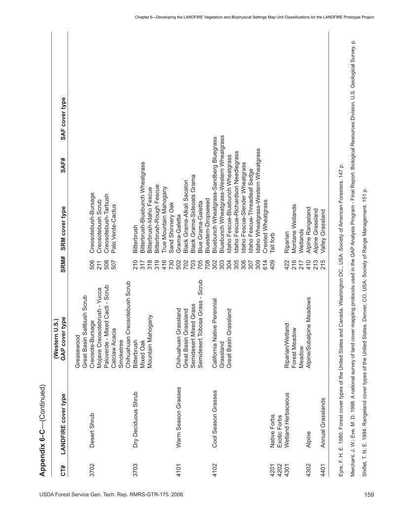
�59USDA Forest Service Gen. Tech. Rep. RMRS-GTR-�75. 2006
Chapter6—DevelopingtheLANDFIREVegetationandBiophysicalSettingsMapUnitClassificationsfortheLANDFIREPrototypeProject
(W
este
rn U
.S.)
CT#
LA
ND
FIR
E co
ver t
ype
GA
P co
ver t
ype
SRM
# SR
M c
over
type
SA
F#
SAF
cove
r typ
e
Gre
asew
ood
Gre
at B
asin
Sal
tbus
h S
crub
�702
D
eser
t Shr
ub
Cre
osot
e-B
ursa
ge
506
Cre
osot
ebus
h-B
ursa
ge
M
ojav
e C
reos
oteb
rush
- Yu
cca
2��
Cre
osot
ebus
h S
crub
Pal
over
de -
Mix
ed C
acti
- Scr
ub
508
Cre
osot
ebus
h-Ta
rbus
h
C
atcl
aw A
caci
a 50
7 P
alo
Verd
e-C
actu
s
S
mok
etre
e
C
hihu
ahua
n C
reos
oteb
ush
Scr
ub�7
0�
Dry
Dec
iduo
us S
hrub
B
itter
brus
h 2�
0 B
itter
brus
h
M
ixed
Oak
��
7 B
itter
brus
h-B
lueb
unch
Whe
atgr
ass
Mou
ntai
n M
ahog
any
��8
Bitt
erbr
ush-
Idah
o Fe
scue
��
9 B
itter
brus
h-R
ough
Fes
cue
��
6 Tr
ue M
ount
ain
Mah
ogan
y
7�0
San
d S
hinn
ery
Oak
��0�
W
arm
Sea
son
Gra
sses
C
hihu
ahua
n G
rass
land
50
2 G
ram
a-G
alet
ta
G
reat
Bas
in G
rass
land
70
2 B
lack
Gra
ma-
Alk
ali S
acat
on
S
emid
eser
t Mix
ed G
rass
70
� B
lack
Gra
ma-
Sid
eoat
s G
ram
a
S
emid
eser
t Tob
osa
Gra
ss -
Scr
ub
705
Blu
e G
ram
a-G
alet
ta
708
Blu
este
m-D
rops
eeed
��02
C
ool S
easo
n G
rass
es
Cal
iforn
ia N
ativ
e P
eren
nial
�0
2 B
lueb
unch
Whe
atgr
ass-
San
dber
g B
lueg
rass
Gra
ssla
nd
�0�
Blu
ebun
ch W
heat
gras
s-W
este
rn W
heat
gras
s
G
reat
Bas
in G
rass
land
�0
� Id
aho
Fesc
ue-B
lueb
unch
Whe
atgr
ass
�0
5 Id
aho
Fesc
ue-R
icha
rdso
n N
eedl
egra
ss
�06
Idah
o Fe
scue
-Sle
nder
Whe
atgr
ass
�0
7 Id
aho
Fesc
ue-T
hrea
dlea
f Sed
ge
�09
Idah
o W
heat
gras
s-W
este
rn W
heat
gras
s
6��
Cre
sted
Whe
atgr
ass
�20�
N
ativ
e Fo
rbs
�0
9 Ta
ll fo
rb�2
02
Exo
tic F
orbs
��0�
W
etla
nd H
erba
ceou
s R
ipar
ian/
Wet
land
�2
2 R
ipar
ian
Fore
st M
eado
w
2�6
Mon
tane
Wet
land
s
M
eado
w
2�7
Wet
land
s��
02
Alp
ine
Alp
ine/
Sub
alpi
ne M
eado
ws
��0
Alp
ine
Ran
gela
nd
2��
Alp
ine
Gra
ssla
nd��
0�
Ann
ual G
rass
land
s
2�5
Valle
y G
rass
land
Eyr
e, F
. H. E
. �98
0. F
ores
t cov
er ty
pes
of th
e U
nite
d S
tate
s an
d C
anad
a. W
ashi
ngto
n D
C.,
US
A: S
ocie
ty o
f Am
eric
an F
ores
ters
. ��7
p.
Mer
chan
t, J.
W.;
Eve,
M. D
. �99
8. A
nat
iona
l sur
vey
of la
nd c
over
map
ping
pro
toco
ls u
sed
in th
e G
AP A
naly
sis
Prog
ram
- Fi
nal R
epor
t. Bi
olog
ical
Res
ourc
es D
ivis
ion,
U.S
. Geo
logi
cal S
urve
y. p
.
Shiflet,T.N.E
.1994.RangelandcovertypesoftheUnitedStates.Denver,CO,U
SA:S
ocietyofR
angeManagem
ent.151p.
App
endi
x 6-
C—
(Con
tinue
d)

�60 USDA Forest Service Gen. Tech. Rep. RMRS-GTR-�75. 2006
Chapter6—DevelopingtheLANDFIREVegetationandBiophysicalSettingsMapUnitClassificationsfortheLANDFIREPrototypeProject
CT# Cover typeNVCSclass
NVCSsubclass
NVCSgroup
1401RiparianHardwooda Forest Deciduous Cold-deciduous
1405 Aspen -- Bircha Forest Deciduous Cold-deciduous
1406
Pacific DeciduousForest [OtherBroadleaf]
Forest,Woodland Deciduous Cold-deciduous woodland
1101
Pacific BroadleafEvergreen Forest[Other BroadleafEvergreen] Forest Evergreen
Winter-rain broad-leavedevergreen sclerophyllousforest
1501 Larch Forest Deciduous Cold-deciduous
1201 Ponderosa Pinea
Forest,Woodland,Herbaceous
Evergreen,Mixedevergreen-deciduousforest,Evergreenwoodland,Perennialgraminoid
Temperate or subpolarneedle-leaved evergreenforest, Temperate or subpolarneedle-leaved evergreenwoodland, Mixed needle-leaved- evergreen - cold-deciduous forest, Mixedneedle-leaved- evergreen -cold-deciduous woodland,Temperate or subpolargrassland with sparse treelayer
1218Pacific PonderosaPine
Forest,Woodland Evergreen
Temperate or subpolarneedle-leaved evergreenforest; Temperate or subpolarneedle-leaved evergreenwoodland
1202 Foothill PinesForest,Woodland Evergreen
Needle-leaved, Temperate orsubpolar needle-leaved-evergreen woodland
1203Western WhitePine Forest Evergreen
Temperate or subpolarneedle-leaved-evergreenforest
1204 Lodgepole PineaForest,Woodland
Evergreen,Mixedevergreen-deciduous
Temperate or subpolarneedle-leaved evergreenforest, Temperate or subpolarneedle-leaved evergreenwoodland, Mixed needle-leaved evergreen - cold-deciduous forest
1205 Douglas-fira Forest
Evergreen,Mixedevergreen-deciduous
Temperate or subpolarneedle-leaved evergreenforest, Mixed needle-leavedevergreen - cold-deciduousforest
Appendix 6-D—Crosswalk of LANDFIRE cover types to the National Vegetation Classification System (NVCS) hierarchy (Grossman and others 1998) ______________________________________________

�6�USDA Forest Service Gen. Tech. Rep. RMRS-GTR-�75. 2006
Chapter6—DevelopingtheLANDFIREVegetationandBiophysicalSettingsMapUnitClassificationsfortheLANDFIREPrototypeProject
1206Grand Fir -- WhiteFira Forest
Evergreen,Mixedevergreen-deciduous
Temperate or subpolarneedle-leaved evergreenforest, Mixed needle-leavedevergreen - cold-deciduousforest
1207Pacific Silver Fir --Noble fir Forest Evergreen
Temperate or subpolarneedle-leaved evergreenforest
1219 Red Fir Forest Evergreen
Temperate or subpolarneedle-leaved evergreenforest
1220 California White Fir Forest Evergreen
Temperate or subpolarneedle-leaved evergreenforest
1209 Western Hemlock Forest Evergreen
Temperate or subpolarneedle-leaved evergreenforest
1210 Mountain Hemlock Forest Evergreen
1211 Spruce -- FiraForest,Woodland
Evergreen,Mixedevergreen-deciduous
Needle-leaved, Temperate orsubpolar needle-leavedevergreen forest, Mixedneedle-leaved evergreen -cold-deciduous forest
1212 Sitka Spruce Forest Evergreen
Temperate or subpolarneedle-leaved evergreenforest
1213 Cedar Forest Evergreen
Temperate or subpolarneedle-leaved evergreenforest
1215 Redwood Forest Evergreen
Temperate or subpolarneedle-leaved evergreenforest
1216 Sequoia Forest Evergreen
Temperate or subpolarneedle-leaved evergreenforest
1217 CypressForest,Woodland Evergreen
Temperate or subpolarneedle-leaved evergreenforest, Temperate or subpolarneedle-leaved evergreenwoodland
1801 Timberline PineaForest,Woodland
Evergreen,Mixedevergreen-deciduousforest
Temperate or subpolarneedle-leaved evergreenforest, Temperate or subpolarneedle-leaved evergreenwoodland, Mixed needle-leaved evergreen - cold-deciduous forest
NVCS NVCS NVCSCT# Cover type class subclass group
Appendix 6-D—(Continued)

�62 USDA Forest Service Gen. Tech. Rep. RMRS-GTR-�75. 2006
Chapter6—DevelopingtheLANDFIREVegetationandBiophysicalSettingsMapUnitClassificationsfortheLANDFIREPrototypeProject
2101 Evergreen Oak
Forest,Woodland,Shrubland
Evergreen,Evergreen-deciduous
Broad-leaved evergreenforest,Temperate broadleafevergreen forest, Temperatebroadleaf evergreenwoodland, Extremelyxeromorphic evergreenwoodland, Mixed broad-leaved evergreen cold-deciduous forest, Temperatebroad-leaved evergreenshrubland
2401 Deciduous Oak
Forest,Woodland,Shrubland,Herbaceous,Shrubland
Deciduous,Mixedevergreen-deciduous
Cold-deciduous, Mixedneedle-leaved-evergreen-cold-deciduous woodland,Temperate or subpolargrassland with a sparse treelayer
2201 Pinyon -- Junipera Woodland EvergreenTemperate or subpolarneedle-leaved evergreen
2202 Junipera Woodland EvergreenTemperate or subpolarneedle-leaved evergreen
3704MountainDeciduous Shruba Shrubland Deciduous Cold-deciduous
3402 Riparian Shruba Shrubland Deciduous Cold-deciduous
3403Exotic RiparianShruba Shrubland Deciduous Cold-deciduous
3101
Mountain BigSagebrushComplexa
Shrubland,Dwarf-shrubland,Herbaceous
Evergreen,Perennialgraminoid
Microphyllous evergreen,Extremely xeromorphicevergreen, Temperate orsubpolar grassland withsparse shrub layer
3102
Wyoming -- BasinBig SagebrushComplexa Shrubland Evergreen Microphyllous evergreen
3103Dwarf SagebrushComplexa
Shrubland,Herbaceous
Evergreen,Perennialgraminoid,Deciduous
Microphyllous evergreen,Temperate or subpolargrassland with a sparseshrub layer, Extremelyxeromorphic deciduousshrubland
3104 Sand Sagebrush Shrubland Evergreen Microphyllous Evergreen
3105 Blackbrusha Shrubland EvergreenExtremely xeromorphicevergreen shrubland
3106 RabbitbrushaShrubland,Herbaceous
Evergreen,Perennialgraminoid
Microphyllous evergreen,Temperate or subpolargrassland with a sparseshrub layer
3107 Chaparrala Shrubland EvergreenTemperate broadleafevergreen
NVCS NVCS NVCSCT# Cover type class subclass group
Appendix 6-D—(Continued)

�6�USDA Forest Service Gen. Tech. Rep. RMRS-GTR-�75. 2006
Chapter6—DevelopingtheLANDFIREVegetationandBiophysicalSettingsMapUnitClassificationsfortheLANDFIREPrototypeProject
3108 Soft Chaparral Shrubland Evergreen
Temperate broad-leavedevergreen shrubland;Microphyllous evergreenshrubland
3301Montane EvergreenShrubs
aShrubland Evergreen
Microphyllous evergreen,Temperate broadleafevergreen
3701 Salt Desert Shruba
Shrubland,Dwarfshrubland
Deciduousshrubland,Evergreendwarfshrubland,Evergreen
Extremely xeromorphicevergreen shrubland,Extremely xeromorphicdeciduous shrubland
3702 Desert Shruba
Shrubland
Evergreenshrubland,Deciduousshrubland
Extremely xeromorphicevergreen shrubland,Extremely xeromorphicdeciduous shrubland,Drought deciduous shrubland
3703Dry DeciduousShrub
aShrubland
Evergreenshrubland,Deciduous
Microphyllous evergreenshrubland, Temperatebroadleaf evergreen, Cold-deciduous shrubland
4101Warm SeasonGrasses
aHerbaceous
Perennialgraminoid
Temperate or subpolargrassland
4102Cool SeasonGrasses
aHerbaceous
Perennialgraminoid
Temperate or subpolargrassland
4201 Native Forbsa
Herbaceous Perennial forbs Forbs
4202 Exotic Forbsa
Herbaceous
4301WetlandHerbaceous
aHerbaceous
Mixedperennialgraminoid/forb,Hydromorphicherbs Mixed Grass/Forbs
4302 Alpinea
Herbaceous
Mixedperennialgraminoid/forbs Mixed Grass/Forbs
4401AnnualGrasslands
aHerbaceous Annual herbs
aRefined with Zone 16 plot data.
Grossman, D. H.; Faber-Langendoen, D.; Weakley, A. S.; Anderson, M.; Bourgeron, P.; Crawford, R.; Goodin, K.;
Landaal, S.; Metzler, K.; Patterson, K.; Pyne, M.; Reid, M.; Sneddon, L. 1998. International classification of ecological
communities: Terrestrial vegetation of the United States Volume I. The National Vegetation Classification System:
development, status, and applications. Arlington VA, USA: The Nature Conservancy. 126 p.
NVCS NVCS NVCSCT# Cover type class subclass group
Appendix 6-D—(Continued)

�6� USDA Forest Service Gen. Tech. Rep. RMRS-GTR-�75. 2006
Chapter6—DevelopingtheLANDFIREVegetationandBiophysicalSettingsMapUnitClassificationsfortheLANDFIREPrototypeProject
Appendix 6-E—Zone 19 cover type legend and descriptions ______________CT# Cover type Description
�20� Cedar Western redcedar (Thuja plicata) is limited to the northwest corner of Zone �9 where it reach-es the eastern limit of its distribution. It is the second most shade-tolerant coniferous species in the zone after western hemlock. Cedar commonly occurs in stands with many other conifer species including Abies grandis, Larix occidentalis, Tsuga heterophylla, Pinus contorta, Pseudotsuga menziesii, Pinus monticola and Picea engelmannii. Understory species may be abundant, and common species include Oploplanax horridus, Gymnocarpium dryopteris, Tiarella trifoliata and Taxus brevifolia. This is a minor type in the zone and is represented by less than � percent of the forested plots in the LFRDB.
1202 Douglas-fir ThisisamajortypewithinZone19andacrossthewesternU.S.,dominatedbyDouglas-fir(Pseudotsuga menziezii) and typically occurring at mid- elevation on a variety of aspects and slopes. This cover type mixes with or may be adjacent to many other cover types across the zone depending on location and local site factors. Common overstory associates include Pinus contorta, Pinus ponderosa, Larix occidentalis and Abies lasiocarpa. Common under-story species vary widely depending on local site factors and stand history but may include Xerophyllum tenax, Calamagrostis rubescens, Vaccinium membranaceum and Symphoricar-pos albus.CoverofDouglas-firaverages32percentandrangesfrom3to90percent.Thirty-three percent of all forested plots fall into this category and 20 percent of all plots.
1203 GrandFir Grandfir(Abies grandis) occurs only in the northern half of the zone and west of the conti-nental divide. It commonly occurs in stands with other conifer species including Pseudotsuga menziesii, Abies lasiocarpa, Thuja plicata, Larix occidentalis and Picea engelmannii. Un-derstory species may be abundant and include Taxus brevifolia, Acer glabrum, Arnica spp., Linnaea borealis and Amelanchier alnifolia.Coverofgrandfiraverages40percentwitharange of �0 to 90 percent. This is a minor type in the zone and is represented by less than � percent of the plots in the database.
�20� Hemlock This cover type, dominated by western hemlock (Tsuga heterophylla), is restricted to the northwest corner of the zone and is the most shade-tolerant conifer in the zone. Western hemlock cover averages 5� percent with a range of �0 to 90 percent. Common overstory associates include Thuja plicata, Abies lasiocarpa, Larix occidentalis, Picea engelmannii, Pseudotsuga menziesii and Pinus contorta. Understory vegetation may be abundant to non-existent depending on the overstory canopy and includes Xerophyllum tenax, Taxus brevi-folia, Amelanchier alnifolia, Acer glabrum, and Arnica latifolia. Western hemlock reaches its eastern range limit within the northwestern portion of the zone and thus is a minor type with only 0.� percent of forested plots occurring here.
�205 Lodgepole Pine Lodgepole Pine is a major type within Zone �9, across the middle and northern Rockies and in portions of the Cascades and Sierra Nevadas. It typically occurs in the montane and lower subalpine zones on a variety of aspects and slopes. This cover type commonly mixeswithorisadjacenttoDouglas-firandSpruce-firtypesandistypicallyseraltothosetypes. Dominated by lodgepole pine (Pinus contorta), common overstory associates include Pinus ponderosa, Larix occidentalis and Abies lasiocarpa. Common understory species vary widely depending on local site factors and stand history, but may include Xerophyllum tenax, Calamagrostis rubescens, Vaccinium membranaceum and Symphoricarpos albus. Cover of lodgepole pine averages �5 percent and ranges from � to 98 percent. Sixteen percent of all forested plots fall into this category and 20 percent of all plots.
�206 Juniper Juniper species are wide-ranging though, as cover types, are found primarily east of the divide in Montana or in the very southern part of Zone �9. Communities are usually open and dominated by species including Juniperus scopulorum and Juniperus osteosperma, with cover averaging 22 percent with a range from � to 50 percent. Common associated species include Artemisia nova, Artemisia tridentata ssp. vaseyana, Pseudoroegneria spicata, Fes-tuca idahoensis and Koeleria macrantha. This is a minor woodland type in the zone and only 0.5 percent of forest and woodland plots occur in this type.

�65USDA Forest Service Gen. Tech. Rep. RMRS-GTR-�75. 2006
Chapter6—DevelopingtheLANDFIREVegetationandBiophysicalSettingsMapUnitClassificationsfortheLANDFIREPrototypeProject
�207 Ponderosa Pine Ponderosa pine (Pinus ponderosa) is distributed across large areas of the zone, though it is absent from several areas including the area south of Salmon, ID. As a cover type, it is limit-ed to some of the lowest elevations and driest sites that are occupied by forest and woodland communities in the zone. At higher elevations or on more mesic sites, Pseudotsuga menzie-siiquicklyreplacesponderosapine.Larix occidentalis and Pinus contorta are other common overstory associates. Understory vegetation may be abundant and common species include Mahonia repens, Calamagrostis rubescens, Symphoricarpos albus, Arctostaphylos uva-ursi, Spiraea betulifolia, Amelanchier alnifolia and Carex geyeri. Cover of ponderosa pine aver-ages �2 percent and ranges from 5 to 70 percent. Only 2 percent of the forested plots are classifiedtothecovertype.
1208 Spruce--Fir Spruce-firisawidespreadcovertypethroughoutZone19,dominatingathighelevationsandoftenmixingwiththeLodgepolePine,Douglas-fir,andTimberlinePinetypes.Standsareusually dominated by Abies lasiocarpa(subalpinefir)andPicea engelmannii (Engelmann spruce). Common overstory associates include Pinus albicaulis, Pseudotsuga menziesii and Pinus contorta. Understory species commonly occurring in this type include Vaccinium mem-branaceum, Xerophyllum tenax, Menziesia ferruginea, Arnica latifolia, Vaccinium scoparium and Luzula glabrata. Approximately 25 percent of forested plots occur in this cover type.
�209 Limber Pine The distribution of this type, dominated by Pinus flexilis, is primarily east of the divide in Montana and in several mountain ranges in the southern portion of the zone. The Limber Pine type occurs at lower elevations where it may co-occur with juniper species and at high elevation timberline sites where it may mix with Pinus albicaulis. Common overstory associ-ates are Pseudotsuga menziesii and Juniperus scopulorum. Common understory species include Arctostaphylos uva-ursi, Dasiphora floribunda, Pseudoroegneria spicata, Festuca idahoensis, Shepherdia canadensis, Juniperus horizontalis and Juniperus communis. Cover of limber pine averages �� percent with a range of � to 50 percent. Approximately � percent of all forested plots occur in this type.
�2�2 White Pine This cover type’s distribution is primarily to the west of Zone �9, just reaching into the northwest corner of Zone �9 and, as such, is only represented by � plots in the LFRDB. It is dominated by Pinus monticola, western white pine.
��0� Aspen -- Birch The Aspen-Birch type is most common east of the Continental Divide, where it ranges from low elevation riparian areas to the montane and lower subalpine zones and is usually dominated by Populus tremuloides (trembling aspen). In the northwest portion of Zone �9, however, Betula papyrifera (paper birch) as the dominant overstory species is more common than aspen. Understory diversity is high and includes many shrub and herbaceous species, including Osmorhiza occidentalis, Prunus virginiana, Acer glabrum, Amelanchier alnifolia, Symphoricarpus albus, Calamagrostis rubescens, Angelica arguta and Thalictrum occiden-tale. Cover of Populus tremuloides averages �2 percent with a range of � to 90 percent. Aspen-birch is much more common in other zones and in Zone �9 is represented by only �.5 percent of the forest plots in the LFRDB.
��02 Riparian The widespread Riparian Hardwood cover type has limited coverage because of its restricted Hardwood habitatrequirements.Itoccupieslowelevationriparianareasalongmajordrainageswhere
it often intermingles with the Riparian Broadleaf Shrubland cover type. Stands of riparian hardwoods at higher elevations are usually small and isolated. Only two cottonwood species occur in riparian hardwoods forests in the zone, Populus angustfolia (narrowleaf cotton-wood), which largely occurs east of the Continental Divide in the eastern and northeastern part of the zone, and Populus balsamifera ssp. trichocarpa (black cottonwood), which occurs throughout the zone. Other deciduous trees such as Acer negundo, and Salix amygdaloides also occur in riparian hardwood communities as well as Pinus ponderosa, Picea engelmannii, and Populus tremuloides. Some common understory associated species include Symphori-carpos albus, Salix spp., Poa pratensis, Acer glabrum and Amelanchier alnifolia. Cover of cottonwood in these communities averages �0 percent with a range of �0 to 60 percent. This is a minor forest type and is represented in the LFRDB by less than � percent of the forest plots.
CT# Cover type Description
Appendix 6-E—(Continued)

�66 USDA Forest Service Gen. Tech. Rep. RMRS-GTR-�75. 2006
Chapter6—DevelopingtheLANDFIREVegetationandBiophysicalSettingsMapUnitClassificationsfortheLANDFIREPrototypeProject
��0� Western Larch This type occurs in the northern half of the zone, predominantly west of the continental divide. Stands dominated by Larix occidentalistypicallyoccuratmid-elevationsandfrequentlymixwithDouglas-firandlodgepolepinetypes.LarchforestsareusuallyseraltoDouglas-fir,grandfirandspruce-firtypes.TypicaloverstoryassociatesarePseudotsuga menziesii and Pinus contorta. Understory species are numerous with some of the most commonly occurring species being Vaccinium membranaceum, Paxistima myrsinites, Rubus parviflorus, Xerophyllum tenax and Acer glabrum. Approximately � percent of forested plots occur in this cover type.
�80� Timberline Forest The Timberline Forest type occurs across the zone and occupies the highest elevations of any of the forested communities. It is generally dominated by Pinus albicaulis (whitebark pine) and can include Larix lyallii (alpine larch). At lower elevations, Timberline Forests typi-cally mix with the Spruce-Fir cover type, and Picea engelmannii and Abies lasiocarpa are both common overstory associates. Common understory associated species include Vac-cinium scoparium, Xerophyllum tenax, Luzula glabrata and Carex geyeri. Cover of Pinus albi-caulis and Larix lyallii averages �9 percent and ranges from � to 50 percent. Approximately � percent of forested plots occur in this cover type.
2�0� Upland Broadleaf This cover type consists of three main dwarf shrub species, Vaccinium scoparium, Salix Dwarf Shrubland artica, and Vaccinium caespitosum. It is found from the upper montane region to the alpine
region. In 77 percent of the plots, the dominant species is Vaccinium scoparium. The remain-ing plots are dominated by either Vaccinium caespitosum or Salix arctica. Both Vaccinium speciesresproutfollowingfire.Salix arctica occursincommunitiesthatrarelyexperiencefire.Common associates in Vaccinium communities include Xerophyllum tenax, Carex geyeri, Vaccinium membranaceum and Luzula glabrata. This is a minor shrub type with approxi-mately 0.5 percent of the total plots falling into this cover type and �.5 percent of all shrub dominated plots occurring here.
2�02 Upland Broadleaf This cover type is dominated by numerous species characterized by medium stature Medium Shrubland (generally � to 8 feet in height) broadleaf shrubs including Symphocarpus spp., Vaccinium
membranaceum, Menziesia ferruginea, Physocarpus malvaceus, Spirea betufolia, Rubus par-viflorus, and various Rosa, Ribes, and Lonicera species. Common associated species outside of those indicated by the dominant species very widely depending on the dominant species and local site factors. Approximately 8 percent of shrub dominated plots occur in this type.
2�0� Upland Broadleaf This cover type consists of several dominant species characterized as tall stature (generally Tall Shrubland greater than 8 feet in height) broadleaf shrubs. These include Alnus viridus ssp. sinuate, Acer
glabrum, Amelanchier alnifolia, Sorbus scopulina, and several Prunus species. Common associated species outside of those indicated by the dominant species include lower stature broadleaf shrubs and a variety of herbaceous species. Approximately 7 percent of shrub dominated plots occur in this type.
2202 Upland Microphyllous This physiognomic grouping is composed of several dominant species characterized as Medium Shrubland medium stature microphyllous shrubs. These communities are generally on lower eleva-
tion arid sites and restricted to the southern portion of the zone. Dominant species include Atriplex confertifolia, Purshia tridentata, Artemisia cana, Tetradymia canescens, Gutierrezia sarothrae, and Atriplex canescens. Common associated species include Artemisia frigida, Hesperostipa comata and Pseudoroegneria spicata. These communities become much more common south of Zone �9. This cover type is of minor importance in the zone with approxi-mately � percent of shrub dominated plots occurring in this type.
22�� Dwarf Sage This cover type is dominated by two morphologically similar species, Artemisia arbuscula and Artemisia nova. Vegetative cover is generally low with only a few commonly occurring shrub and grass species. Common associates include Pseudoroegneria spicata, Artemisia tridentata ssp. wyomingensis, Artemisia frigida and Heterostipa comata. Cover of sagebrush average �7 percent with a range of � to 50 percent. Occurrence of this cover type in Zone �9 is minor though it is much more abundant in other parts of the western U.S. Very little plot data exists for dwarf sage communities in the zone with 0.� percent of the total plots falling into this cover type and 0.� percent of all shrub dominated plots occurring here.
CT# Cover type Description
Appendix 6-E—(Continued)

�67USDA Forest Service Gen. Tech. Rep. RMRS-GTR-�75. 2006
Chapter6—DevelopingtheLANDFIREVegetationandBiophysicalSettingsMapUnitClassificationsfortheLANDFIREPrototypeProject
2212 ShrubbyCinquefoil Thiscovertypeoccursatmidtoupperelevationsbetween4,500ftand8,500ft.Dasiphora floribunda(shrubbycinquefoil),thedominantspeciesinthistype,possessestheabilitytoresproutfollowingfiredependingonfireseverity;itisusuallykilledbyhighseverityfire.Common associated species include Festuca idahoensis, Koeleria macrantha, Fragaria virginiana, Danthonia intermedia and Potentilla gracilis.Coverofshrubbycinquefoilaverages�5 percent with a range of � to �0 percent. This is a minor type in the zone with less than � percent of shrub dominated plots occurring in this cover type.
22�� Threetip Sage This is a minor type in southwest Montana and becomes more abundant in the Idaho portion of the zone. Artemisia tripartita (threetip sage) is different from other sagebrush types in the zonebecauseofitsabilitytoresproutafterfire,thoughtheabilityvariesamongpopulations.Common associated species include Chrysothamnus viscidiflorus, Gutierrezia sarothrae, Pseudoroegneria spicata. Cover of threetip sage averages 28 percent with a range of �0 to �5 percent. This type is represented by 2� percent of the shrub dominated plots in the zone. An abundance of plot data exists for this type, but it is clustered in a relatively small area of the zone so the amount of plot data over-represents its actual occurrence in the zone.
22�8 Mountain Big Sage Mountain Big Sage cover type (dominated by Artemisia tridentata ssp. vaseyana) generally occurs at higher elevations than the Wyoming-Basin Big Sage cover type and ranges to the subalpine region. Though present throughout Zone �9, it is most abundant in Idaho and in Montana generally south and east of Missoula. Common associated species include Festuca idahoensis, Pseudoroegneria spicata, Geranium viscosissimum and Lupinus species. Cover of Artemisia tridentata ssp. vaseyana averages 29 percent with a range of � to 70 percent. This is a major shrub type across the zone with �8 percent of shrub-dominated plots occurring here.
22�9 Wyoming -- Basin This is a major shrub type in the southern half of the zone and a landscape dominant across Big Sage vast areas of the West. Dominant species for this type are Artemisia tridentata ssp. triden-
tate, and Artemisia tridentata ssp. wyomingensis. Other common species include Agropyron cristatum, Pseudoroegneria spicata, Poa fendleriana, Artemisia frigida, Achnatherum hymen-oides, Heterostipa comata, Chrysothamnus viscidiflorus and Koeleria macrantha. This type is represented by �� percent of the shrub dominated plots in the zone. An abundance of plot data exists for this type but it is clustered in a relatively small area of the zone so the amount of plot data over-represents its actual occurrence in the zone.
2220 Rabbitbrush This cover type is composed of two species of rabbitbrush within the zone, including Chryso-thamnus viscidiflorus (yellow rabbitbrush) and Ericameria nauseosa (rubber rabbitbrush). It is a minor type in the zone and is usually adjacent to Wyoming-Basin Big Sage, Mountain BigSageorherbaceousdominatedcovertypes.Rabbitbrushmayquicklyrecolonizeasitefollowingfirefromsproutsandfromseed.CommonassociatedspeciesincludeArtemisia frigida, Pseudoroegneria spicata, Festuca idahoensis, Hesperostipa comata, Artemisia tridentata ssp. wyomingensis, Artemisia tridentata ssp. vaseyana, Poa fendleriana and Agropyron cristatum. Cover of rabbitbrush species averages 8 percent with a range of � to �0 percent. Less than 2 percent of shrub-dominated plots occur in this cover type.
2222 Greasewood Sarcobatus vermiculatus is the sole dominant species in this cover type. Though a minor type in Zone �9, it is a common species in other areas of the west with a distribution centered on the Great Basin Floristic Division. Black greasewood communities generally occur below the more moist sagebrush or shadscale zones and in Zone �9 are typically found on old alluvial terraces (Roundy and others �978). Greasewood commonly grows in pure stands in high saline areas with little or no understory vegetation, but in less saline areas, other shrubs may be common as well as a grass component (McArthur and Plummer �978). Generally, greasewoodcommunitiessufferlittledamagefromfireandfireoccurrenceisminimalduetoalackoffinefuels.However,greasewoodcommunitiesinvadedbycheatgrassmayhaveanincreaseinfireoccurance.Speciesdiversityislow,butcommonassociatesincludeAgropy-ron cristatum, Artemisia frigida and Pseudoroegneria spicata. Cover of greasewood averages �5 percent with a range of �0 to 70 percent. Plot data is almost nonexistent for greasewood communities in the zone and less than 0.� percent of the total plots fall into this cover type and 0.2 percent of all shrub dominated plots occur here.
CT# Cover type Description
Appendix 6-E—(Continued)

�68 USDA Forest Service Gen. Tech. Rep. RMRS-GTR-�75. 2006
Chapter6—DevelopingtheLANDFIREVegetationandBiophysicalSettingsMapUnitClassificationsfortheLANDFIREPrototypeProject
222� Mountain Mahogany This cover type is restricted to the south half of the zone where it reaches its northerly range limit. Stands of this type typically occur at mid elevations on dry, southerly slopes. Cercocar-pus ledifolius (mountain mahogany), the dominant species in this type, isusuallykilledbyfireand relies on seed to reoccupy a site though regeneration may be slow (Scheldt and Tisdale �970). Common associated species include Festuca idahoensis, Pseudoroegneria spicata, Artemisia tridentata ssp. vaseyana and Artemisia tridentata ssp. wyomingensis. Mountain mahogany cover averages �0 percent with a range of � to 70 percent. This type is relatively minor across the zone though locally abundant in Idaho. Less than � percent of shrub domi-natedplotsareclassifiedtothistype.
2�00 Upland Needleleaf This physiognomic grouping is composed of dwarf to medium height needle-leaved shrub that typically form small patches in a variety of sites. On lower elevation dry sites, the domi-
nant Shrubland species are Juniperus communis and Juniperus horizontalis, which account for 85 percent of the plots. These sites typically have sparse fuel. The remaining plots are dominated by Phyllodoce empetriformis, which occupies sites within the subalpine to lower alpine zones and are adjacent to or intermingled with subalpine forest types, herbaceous dominated alpine communities, or barren, rocky slopes. This is a very minor shrub type with approximately 0.2 percent of the total plots falling into this cover type and 0.8 percent of all shrub dominated plots occurring here.
2�00 Upland Sclerophyllous This physiognomic grouping is composed of dwarf to medium height sclerophyllous-leaved Shrubland shrubs that typically form small patches mainly within the montane zone. It is comprised of
three dwarf shrubs, Arctostaphylos uva-ursi, Paxistima myrsinites, and Mahonia repens, which dominate 72 percent of the plots in this type, and one medium-height shrub species, Ceanothus velutinus, on 28 percent of the plots. All species possess the ability to resprout followingfireandCeanothus velutinusinparticularmayrecolonizeasiteafterfirefromon-site seed sources. This is a minor shrub type with approximately 0.� percent of the total plots falling into this cover type and � percent of all shrub dominated plots occurring here.
2600 Riparian Broadleaf This cover type is composed of native shrub communities dominated mainly by Alnus incana Shrubland or by one of several Salix species. This type occupies riparian areas along major drainages.
WhereitisintermingledwiththeRiparianHardwoodcovertype,theshrubsareusuallyquitetall and some species may be single-stemmed and tree-like. At lower elevations, these com-munitiesusuallyhaveapatchydistributionduetoflooddynamicsandmorerecently,humandisturbances. At higher elevations, communities may occur as narrow stringers along low gradient streams or as broader patches that extend away from streams and into adjacent wet meadows where they often form mosaics with herbaceous-dominated communities. Overall, this is a minor though important landscape component with approximately 0.6 percent of the total plots falling into this cover type and 2 percent of all shrub dominated plots occurring here.
���0 Annual Forb The Annual Forb cover type includes forbs that are annual or biennial species. This type usually occurs at lower elevation xeric sites across the zone and is composed of mostly naturalized species but also includes species that may be the result of seeding for restora-tion or forage in the cases of Melilotus officianalis or Triticum aestivum. Species composition varies widely and includes numerous forbs, natives and exotics, and annual and perennials in various mixtures. Approximately 0.2 percent of the total plots fall into this cover type and � percent of all herbaceous dominated plots occur in this cover type when combined with an-nual graminoid.
��20 Annual Graminoid Bromus tectorumisthedominantspeciesonthezone19plotsclassifiedtothiscovertype.This type usually occurs at lower elevation xeric sites across the zone and is composed of mostly naturalized species. Species composition varies widely and includes numerous graminoids, natives, and exotics, and annuals, biennals and perennials in various mixtures. Approximately 0.2 percent of the total plots fall into this cover type.
CT# Cover type Description
Appendix 6-E—(Continued)

�69USDA Forest Service Gen. Tech. Rep. RMRS-GTR-�75. 2006
Chapter6—DevelopingtheLANDFIREVegetationandBiophysicalSettingsMapUnitClassificationsfortheLANDFIREPrototypeProject
���0 Perennial Forb The Perennial Forb cover type consists of communities dominated mainly by native and occasionally exotic forbs. Occurring on xeric to mesic sites and ranging from the lowest elevations in the zone to the alpine region, species composition may vary widely. Artemisia frigida is the dominant species on almost �0 percent of the plots, and no other species domi-nant on more than 5 percent. The vertical structure of this type ranges from tall forbs such as Chamerion angustifolium to cushion plants such as Phlox hoodii. Approximately 2 percent of the total plots fall into this cover type and 2� percent of all herbaceous dominated plots.
���� Perennial Exotic Fifty-eight percent of the plots in this type are dominated by Phleum pratense (timothy). Plots Bunch Gramminoid occur on a variety of sites, ranging from low elevation xeric to mesic montane sites. Areas
dominated by these grasses may be the result of seeding for restoration or pasture or at least have been subject to moderate to heavy disturbance in the past. Approximately 0.2 percent of the total plots fall into this cover type and � percent of all herbaceous dominated plots are classifiedtothistype.
���2 Perennial Native This cover type is mainly composed of low to moderate elevation communities dominated by Bunch Gramminoid Festuca idahoensis, Festuca altaica, and Pseudoroegneria spicata. These dominant species
account for 82 percent of the plot data in this type and are the dominant grassland communi-ties in Zone �9. These plots may occur at any elevation and on xeric to mesic sites. These species usually have a clumped or bunched growth form but may possess short rhizomes in some cases. Approximately � percent of the total plots fall into this cover type and �9 percent ofallherbaceousdominatedplotsareclassifiedtothiscovertype.
��5� Perennial Exotic Fifty percent of the plots in this cover type are dominated by Poa pratensis. The plots Rhizomatous typically occur on low elevation xeric to mesic montane sites. Areas dominated by these Gramminoid grasses may be the result of seeding for restoration or pasture or at least have been subject
to moderate to heavy disturbance in the past. Approximately 0.2 percent of the total plots fallintothiscovertypeand3percentofallherbaceousdominatedplotsareclassifiedtothistype.
��52 Perennial Native Calamagrostis rubescens and Carex geyeri dominate 80 percent of the plots in this cover Rhizomatous type. The remaining plots are dominated by a variety of species. Plots are found in areas Gramminoid ranging from low elevation xeric sites to mesic montane or subalpine sites. This cover type is
composed of species that typically have a rhizomatous, stoloniferous, or sod-forming growth form, but may be clumped or bunched in some cases. Approximately 0.� percent of the total plotsfallintothiscovertypeand5percentofallherbaceousdominatedplotsareclassifiedtothis cover type.
�200 Wetland Herbaceous This cover type is dominated by perennial native rhizomatous gramminoids, including Carex and Juncus species, and several native perennial forb dominated communities would also beclassifiedhere.Thisminortypeisscatteredacrossthezonefromlowtohighelevations.Approximately 0.� percent of the total plots fall into this cover type and 5 percent of all herba-ceousdominatedplotsareclassifiedtothiscovertype.
McArthur, E. D.; Plummer, A. P. �978. Biography and management of native western shrubs: a case study, section Tridentatae of Artemisia. Great Basin Naturalist Memoirs (2): 229-2��.
Roundy,B.A.;Blackburn,W.H.;Jr.,R.E.E.1978.Influenceofprescribedburningoninfiltrationandsedimentproductioninthepinyon-juniperwoodland. Nevada Journal of Range Mangement (��): 250-25�.
Scheldt, R. S.; Tisdale, E. W. �970. Ecology and utilization of curl-leaf mountain mahagany in Idaho. Station Note �5. Moscow, ID: University of Idaho College of Forestry, Wildlife and Range Sciences. p.
CT# Cover type Description
Appendix 6-E—(Continued)
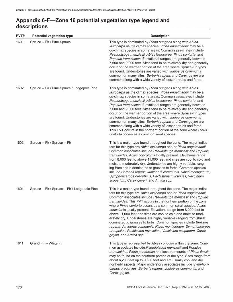
�70 USDA Forest Service Gen. Tech. Rep. RMRS-GTR-�75. 2006
Chapter6—DevelopingtheLANDFIREVegetationandBiophysicalSettingsMapUnitClassificationsfortheLANDFIREPrototypeProject
Appendix 6-F—Zone 16 potential vegetation type legend and descriptions ______________________________________________________PVT# Potential vegetation type Description
�60� Spruce -- Fir / Blue Spruce This type is dominated by Picea pungens along with Abies lasiocarpa as the climax species. Picea engelmannii may be a co-climax species in some areas. Common associates include Pseudotsuga menziesii, Abies lasiocarpa, Pinus contorta, and Populus tremuloides. Elevational ranges are generally between 7,600 and 9,000 feet. Sites tend to be relatively dry and generally occur on the warmer portion of the area where Spruce-Fir types are found. Understories are varied with Juniperus communis common on many sites. Berberis repens and Carex geyeri are common along with a wide variety of lesser shrubs and forbs.
�602 Spruce -- Fir / Blue Spruce / Lodgepole Pine This type is dominated by Picea pungens along with Abies lasiocarpa as the climax species. Picea engelmannii may be a co-climax species in some areas. Common associates include Pseudotsuga menziesii, Abies lasiocarpa, Pinus contorta, and Populus tremuloides. Elevational ranges are generally between 7,600 and 9,000 feet. Sites tend to be relatively dry and generally occur on the warmer portion of the area where Spruce-Fir types are found. Understories are varied with Juniperus communis common on many sites. Berberis repens and Carex geyeri are common along with a wide variety of lesser shrubs and forbs. This PVT occurs in the northern portion of the zone where Pinus contorta occurs as a common seral species.
�60� Spruce -- Fir / Spruce -- Fir This is a major type found throughout the zone. The major indica-tors for this type are Abies lasiocarpa and/or Picea engelmannii. Common associates include Pseudotsuga menziesii and Populus tremuloides. Abies concolor is locally present. Elevations range from 8,000 feet to above ��,000 feet and sites are cool to cold and moist to moderately dry. Understories are highly variable, rang-ing from shrub dominated to grasses to forbs. Common species include Berberis repens, Juniperus communis, Ribes montigenum, Symphoricarpos oreophilus, Pachistima myrsinites, Vaccinium scoparium, Carex geyeri, and Arnica spp.
�60� Spruce -- Fir / Spruce -- Fir / Lodgepole Pine This is a major type found throughout the zone. The major indica-tors for this type are Abies lasiocarpa and/or Picea engelmannii. Common associates include Pseudotsuga menziesii and Populus tremuloides. This PVT occurs in the northern portion of the zone where Pinus contorta occurs as a common seral species. Abies concolor is locally present. Elevations range from 8,000 feet to above ��,000 feet and sites are cool to cold and moist to mod-erately dry. Understories are highly variable ranging from shrub dominated to grasses to forbs. Common species include Berberis repens, Juniperus communis, Ribes montigenum, Symphoricarpos oreophilus, Pachistima myrsinites, Vaccinium scoparium, Carex geyeri, and Arnica spp.
�6�� Grand Fir -- White Fir This type is represented by Abies concolor within the zone. Com-mon associates include Pseudotsuga menziesii and Populus tremuloides. Pinus ponderosa and lesser amounts of Pinus flexilis may be found on the southern portion of the type. Sites range from about 6,200 feet up to 9,600 feet and are usually cool and dry, northerly aspects. Major understory associates include Symphori-carpos oreophilus, Berberis repens, Juniperus communis, and Carex geyeri.

�7�USDA Forest Service Gen. Tech. Rep. RMRS-GTR-�75. 2006
Chapter6—DevelopingtheLANDFIREVegetationandBiophysicalSettingsMapUnitClassificationsfortheLANDFIREPrototypeProject
�6�2 Grand Fir -- White Fir / Maple This PVT is indiciated by Acer grandidentatum and generally occurs in relatively pure stands or interspersed with Quercus, Artemisia, Pseudotsuge menziezii, and Abies concolor communities and is usually found in canyon bottoms and on portions of side slopes with deep, well developed modal soils. In settings where it is at the edge of its ecological range, it normally occurs more shrublike.
1621 Douglas-fir/TimberlinePine Pseudotsuga menziesii, in conjunction with either Pinus flexilis or Pinus longaeva, are indicators for this PVT. Other species com-monly found include Pinus ponderosa, Juniperus scopulorum and Populus tremuloides. Minor amounts of Pinus edulis may also be encountered. The PVT is generally found on steep southerly aspects where windy conditions are common resulting in very dry sites. Elevations range from 6,500 to 9,000 feet and the site repre-sents the very dry end of Pseudotsuga menziesii sites. Understories are usually sparse, shrubby and composed of various mixtures of Symphoricarpos oreophilus, Juniperus communis, Cercocarpus ledifolius, Pachistima myrsinites, Artemisia spp., and Amelanchier alnifolia. The type occurs sporadically throughout the zone.
1622 Douglas-fir/Douglas-fir Pseudotsuga menziesii is the sole indicator of this type. Pinus ponderosa and Populus tremuloides are common associates. Ju-niperus scopulorum may be a minor associate. The type is found on a variety of site conditions ranging in elevation from 5,000 to 9,500 feet. Sites range from warm and dry to cool, moderately moist conditions. Understories are a mixture of shrubs and grass-es including Physocarpus malvaceus, Acer glabrum, Amelanchier alnifolia, Berberis repens, Arnica cordifolia, and Carex geyeri.
1623 Douglas-fir/LodgepolePine ThistypeisindicatedbythecombinationofPseudotsuga menzie-sii and Pinus contorta. While sites may be relatively warm, they represent the cooler portion of the Pseudotsuga menziesii environ-ment and vary from moist to dry. Other common species include Pinus ponderosa and Populus tremuloides. Elevations range from about 5,500 to 7,500 feet. The type is found only in the northern half of the zone. Understories tend to be shrubby and include Symphoricarpos oreophilus, Berberis repens, and Juniperus com-munis along with some taller shrubs such as Amelanchier alnifolia.
�6�� Timberline Pine Pinus flexilis and/or Pinus longaeva are the indicators of this type. Juniperus scopulorum and minor amounts of Pseudotsuga menziesii or Populus tremuloides may be present on some sites. Standsarefrequentlyfoundonverysteepsouthorsouthwestaspects. Conditions are generally the most adverse for tree growth and the type often represents the lower timberline. Elevations range from 7,000 to �0,200 feet. Understories are shrubby and composed of various mixtures of Artemisia tridentata, Symphori-carpos oreophilus, Berberis repens, Cercocarpus ledifolius, Pachistima myrsinites, and Juniperus communis.
�6�2 Ponderosa Pine Pinus ponderosa is the only indicator species for this type. Other trees commonly found are Juniperus scopulorum and Populus tremuloides. Occasionally Pinus edulis and Juniperus osteosper-ma may be found. Sites range in elevation from 6,800 to 9,000 feet. Sites are typically gentle to moderate usually on southerly exposures. Understories are varied and vary from shrubby to grass dominated. Common species include Amelanchier alnifolia, Artemisia tridentata, Quercus gambelii, Symphoricarpos oreophi-lus, Carex geyeri, Festuca idahoensis, and Sitanion hystrix.
PVT# Potential vegetation type Description
Appendix 6-F—(Continued)

�72 USDA Forest Service Gen. Tech. Rep. RMRS-GTR-�75. 2006
Chapter6—DevelopingtheLANDFIREVegetationandBiophysicalSettingsMapUnitClassificationsfortheLANDFIREPrototypeProject
�6�� Lodgepole Pine Pinus contort,a in the absence of other shade tolerant conifers, is the sole indicator of this type. Populus tremuloides may occupy some sites. The type is found on a variety of landforms, which are mostly warm and droughty although it is also found on season-ally moist sites. Elevations range from about 7,600 to �0,000 feet. Understories are commonly sparse and variable. The most commonly found species include Juniperus communis, Vaccinium scoparium, Vaccinium caespitosum, Arctostaphylos uva-ursi, Ber-beris repens, and Calamagrostis canadensis.Thetypeisconfinedto the northern half of the zone.
�6�� Aspen The PVT is characterized by Populus tremuloidesthatfrequentlymakes up pure stands. The type spans a broad range of environ-mentsrangingfromhigh-elevationcool,moistspruce-firforeststothe relatively dry, low-elevation sagebrush steppes. As a result of this wide environmental span, the understory vegetation is highly variable. Symphoricarpos oreophilus is a common shrub along with varying amounts of Berberis repens, Juniperus communis, Rosa woodsii, and Amelanchier alnifolia. Bromus carinatus and Elymus glaucus are common grasses and Geranium viscosissi-mum, Rudbeckia occidentalis, Lathyrus leucanthus, and Lathyrus lanszwertii are common forbs.
�6�� Pinyon -- Juniper / Mountain Big This type is indicated by the presence of Pinus edulis and/or Sagebrush / North Juniperus osteosperma in conjuction with Artemisia tridentata var.
vaseyana. Sites are at moderate elevations and occupy the upper reaches of the Pinyon-Juniper PVTs. Slopes may be gradual to steep. This type occurs mostly in the northern part of the zone where pinyon pine is less prevalent.
�6�2 Pinyon -- Juniper / Mountain Big This type is indicated by the presence of Pinus edulis and/or Sagebrush / South Juniperus osteosperma in conjuction with Artemisia tridentata var.
vaseyana. Sites are at moderate elevations and occupy the upper reaches of the Pinyon-Juniper PVTs. Slopes may be gradual to steep. This type occurs mostly in the southern part of the zone where pinyon pine is more prevalent..
�6�� Pinyon -- Juniper / Wyoming -- This type is indicated by the presence of Pinus edulis and/or Basin Big Sagebrush / North Juniperus osteosperma in conjuction with Artemisia tridentata
var. wyomingensis or var. tridentata. Sites are at low to moderate elevations and occupy the lower reaches of the Pinyon-Juniper PVTs. Slopes may be gradual to steep. This PVT commonly inter-mixes with the Wyoming-Basin Big Sagebrush PVT at the lower end. This type is very common in the northern part of the zone where pinyon pine is less prevalent.
�6�� Pinyon -- Juniper / Wyoming -- This type is indicated by the presence of Pinus edulis and/or Basin Big Sagebrush / South Juniperus osteosperma in conjuction with Artemisia tridentata
var. wyomingensis or var. tridentata. Sites are at low to moderate elevations and occupy the lower reaches of the Pinyon-Juniper PVTs. Slopes may be gradual to steep. This PVT commonly inter-mixes with the Wyoming-Basin Big Sagebrush PVT at the lower end. This type is very common in the southern part of the zone where pinyon pine is more prevalent.
�6�5 Pinyon -- Juniper / Mountain Mahogany Cercocarpus ledifolius is the indicator species for this PVT. Sites are typically on mid elevation, steep slopes and are usually inter-spersedwithPinyon-Juniper,Douglas-fir,orWhiteFirPVTs.This
PVT# Potential vegetation type Description
Appendix 6-F—(Continued)

�7�USDA Forest Service Gen. Tech. Rep. RMRS-GTR-�75. 2006
Chapter6—DevelopingtheLANDFIREVegetationandBiophysicalSettingsMapUnitClassificationsfortheLANDFIREPrototypeProject
type may occur throughout most of the zone. However, it usually occurs in relatively small patches and is of minor importance since most sites that are dominated by Cercocarpus ledifolius are prob-ably seral to other PVTs.
�6�6 Pinyon -- Juniper / Gambel Oak The indicator for this PVT is Quercus gambelii. Sites are typically onmidelevationslopes(5,500ft.to7,800ft.)andarefrequentlyborderedbyPinyon-JuniperPVTsonlowerslopesandDouglas-firor White Fir PVTs on the upper end. This type may occur through-out most of the zone.
�65� Blackbrush Coleogyne ramosissima is the sole indicator species in this PVT. Sites occur in a transition zone between the Mohave and Great Basin Deserts and in the Colorado River Drainage in the southern portion of the zone. The Salt Desert Shrub PVT commonly inter-mixes with Blackbrush at the lower end of the PVT.
�652 Salt Desert Shrub These sites are indicated by the presence of various shrub spe-cies, mostly in the Chenopodiaceae family. Species representative of this PVT include Atriplex confertifolia, Atriplex corrugata, Kochia americana, Sarcobatus vermiculatus, Sueda torreyana, and/or Artemisia spinescens. Sites are low elevation and usually occupy basin bottoms that have accumulations of saline or alkaline depos-its.Sitesmayalsooccuronslopeswithfinetexturedsoilsderivedfrom formations such as the Mancos Shale and Tropic Shale. Total vegetation cover is usually relatively sparse though may be dense in some communities such as black greasewood.
�65� Warm Herbaceous This PVT is represented by mid to low elevation grassland types, generally intermixed with Wyoming-Basin Big Sagebrush PVT and the Salt Desert Shrub PVT.
�65� Cool Herbaceous This PVT is represented by mid to high elevation grassland types, generally intermixed with the Mountain Big Sagebrush PVT and the Alpine PVT.
�66� Dwarf Sagebrush This PVT includes sites occupied by either Artemisia nova or Artemisia arbuscula. Sites are harsher than adjacent Artemisia tri-dentata PVT’s and typically have shallow soil development. These communities are mostly at low elevations but may occur much higher in limited areas.
�662 Wyoming -- Basin Big Sagebrush Artemisia tridentata var. wyomingensis or var. tridentata are the indicators of this type. Sites are low elevation and are commonly onflattogradualslopes.ThesesitescommonlyintermixwiththePinyon-Juniper/Wyoming-Basin Big Sagebrush and Mountain Big Sagebrush PVTs on the upper end of the type. On lower eleva-tions, it commonly intermixes with the Dwarf Sagebrush and the Salt Desert Shrub PVTs. This is a dominant PVT thoughout the zone in valley locations.
�66� Mountain Big Sagebrush Artemisia tridentata var. vaseyana is the indicator of this type. Sites are at moderate to high elevations and are common on un-forestedareasonthecentralplateaus.Slopesmaybealmostflatto relatively steep. Many other PVTs may border this one depend-ing on elevation, soils and local topographic features.
PVT# Potential vegetation type Description
Appendix 6-F—(Continued)
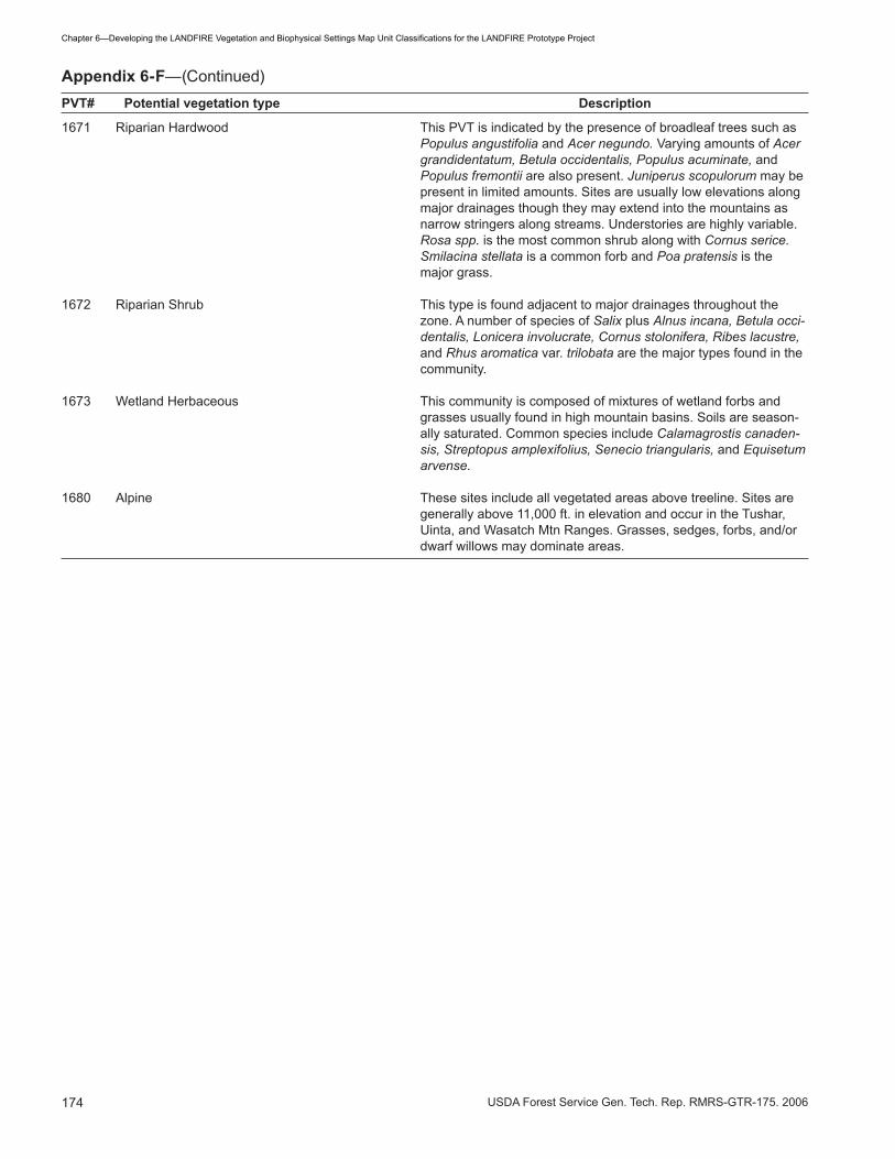
�7� USDA Forest Service Gen. Tech. Rep. RMRS-GTR-�75. 2006
Chapter6—DevelopingtheLANDFIREVegetationandBiophysicalSettingsMapUnitClassificationsfortheLANDFIREPrototypeProject
PVT# Potential vegetation type Description
�67� Riparian Hardwood This PVT is indicated by the presence of broadleaf trees such as Populus angustifolia and Acer negundo. Varying amounts of Acer grandidentatum, Betula occidentalis, Populus acuminate, and Populus fremontii are also present. Juniperus scopulorum may be present in limited amounts. Sites are usually low elevations along major drainages though they may extend into the mountains as narrow stringers along streams. Understories are highly variable. Rosa spp. is the most common shrub along with Cornus serice. Smilacina stellata is a common forb and Poa pratensis is the major grass.
�672 Riparian Shrub This type is found adjacent to major drainages throughout the zone. A number of species of Salix plus Alnus incana, Betula occi-dentalis, Lonicera involucrate, Cornus stolonifera, Ribes lacustre, and Rhus aromatica var. trilobata are the major types found in the community.
�67� Wetland Herbaceous This community is composed of mixtures of wetland forbs and grasses usually found in high mountain basins. Soils are season-ally saturated. Common species include Calamagrostis canaden-sis, Streptopus amplexifolius, Senecio triangularis, and Equisetum arvense.
�680 Alpine These sites include all vegetated areas above treeline. Sites are generally above ��,000 ft. in elevation and occur in the Tushar, Uinta, and Wasatch Mtn Ranges. Grasses, sedges, forbs, and/or dwarf willows may dominate areas.
Appendix 6-F—(Continued)
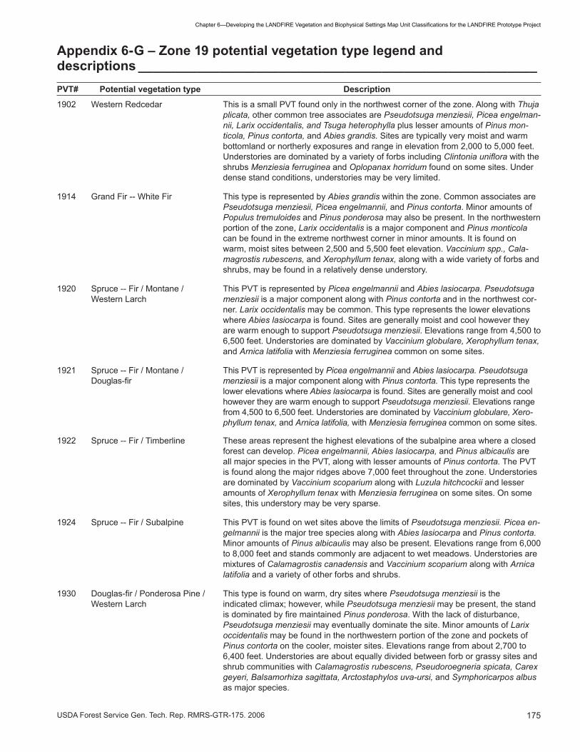
�75USDA Forest Service Gen. Tech. Rep. RMRS-GTR-�75. 2006
Chapter6—DevelopingtheLANDFIREVegetationandBiophysicalSettingsMapUnitClassificationsfortheLANDFIREPrototypeProject
Appendix 6-G – Zone 19 potential vegetation type legend and descriptions ______________________________________________________PVT# Potential vegetation type Description
�902 Western Redcedar This is a small PVT found only in the northwest corner of the zone. Along with Thuja plicata, other common tree associates are Pseudotsuga menziesii, Picea engelman-nii, Larix occidentalis, and Tsuga heterophylla plus lesser amounts of Pinus mon-ticola, Pinus contorta, and Abies grandis. Sites are typically very moist and warm bottomland or northerly exposures and range in elevation from 2,000 to 5,000 feet. Understories are dominated by a variety of forbs including Clintonia uniflora with the shrubs Menziesia ferruginea and Oplopanax horridum found on some sites. Under dense stand conditions, understories may be very limited.
�9�� Grand Fir -- White Fir This type is represented by Abies grandis within the zone. Common associates are Pseudotsuga menziesii, Picea engelmannii, and Pinus contorta. Minor amounts of Populus tremuloides and Pinus ponderosa may also be present. In the northwestern portion of the zone, Larix occidentalis is a major component and Pinus monticola can be found in the extreme northwest corner in minor amounts. It is found on warm, moist sites between 2,500 and 5,500 feet elevation. Vaccinium spp., Cala-magrostis rubescens, and Xerophyllum tenax, along with a wide variety of forbs and shrubs, may be found in a relatively dense understory.
�920 Spruce -- Fir / Montane / This PVT is represented by Picea engelmannii and Abies lasiocarpa. Pseudotsuga Western Larch menziesii is a major component along with Pinus contorta and in the northwest cor-
ner. Larix occidentalis may be common. This type represents the lower elevations where Abies lasiocarpa is found. Sites are generally moist and cool however they are warm enough to support Pseudotsuga menziesii. Elevations range from �,500 to 6,500 feet. Understories are dominated by Vaccinium globulare, Xerophyllum tenax, and Arnica latifolia with Menziesia ferruginea common on some sites.
�92� Spruce -- Fir / Montane / This PVT is represented by Picea engelmannii and Abies lasiocarpa. Pseudotsuga Douglas-fir menziesii is a major component along with Pinus contorta. This type represents the
lower elevations where Abies lasiocarpa is found. Sites are generally moist and cool however they are warm enough to support Pseudotsuga menziesii. Elevations range from �,500 to 6,500 feet. Understories are dominated by Vaccinium globulare, Xero-phyllum tenax, and Arnica latifolia, with Menziesia ferruginea common on some sites.
�922 Spruce -- Fir / Timberline These areas represent the highest elevations of the subalpine area where a closed forest can develop. Picea engelmannii, Abies lasiocarpa, and Pinus albicaulis are all major species in the PVT, along with lesser amounts of Pinus contorta. The PVT is found along the major ridges above 7,000 feet throughout the zone. Understories are dominated by Vaccinium scoparium along with Luzula hitchcockii and lesser amounts of Xerophyllum tenax with Menziesia ferruginea on some sites. On some sites, this understory may be very sparse.
�92� Spruce -- Fir / Subalpine This PVT is found on wet sites above the limits of Pseudotsuga menziesii. Picea en-gelmannii is the major tree species along with Abies lasiocarpa and Pinus contorta. Minor amounts of Pinus albicaulis may also be present. Elevations range from 6,000 to 8,000 feet and stands commonly are adjacent to wet meadows. Understories are mixtures of Calamagrostis canadensis and Vaccinium scoparium along with Arnica latifolia and a variety of other forbs and shrubs.
1930 Douglas-fir/PonderosaPine/ Thistypeisfoundonwarm,drysiteswherePseudotsuga menziesii is the Western Larch indicated climax; however, while Pseudotsuga menziesii may be present, the stand
isdominatedbyfiremaintainedPinus ponderosa. With the lack of disturbance, Pseudotsuga menziesii may eventually dominate the site. Minor amounts of Larix occidentalis may be found in the northwestern portion of the zone and pockets of Pinus contorta on the cooler, moister sites. Elevations range from about 2,700 to 6,400feet.Understoriesareaboutequallydividedbetweenforborgrassysitesandshrub communities with Calamagrostis rubescens, Pseudoroegneria spicata, Carex geyeri, Balsamorhiza sagittata, Arctostaphylos uva-ursi, and Symphoricarpos albus as major species.

�76 USDA Forest Service Gen. Tech. Rep. RMRS-GTR-�75. 2006
Chapter6—DevelopingtheLANDFIREVegetationandBiophysicalSettingsMapUnitClassificationsfortheLANDFIREPrototypeProject
1931 Douglas-fir/Ponderosa Thistypeisfoundonwarm,drysiteswherePseudotsuga menziesii is the Pine/Douglas-fir indicatedclimax;however,whilePseudotsuga menziesii may be present, the stand isdominatedbyfiremaintainedPinus ponderosa. With the lack of disturbance, Pseu-
dotsuga menziesii may eventually dominate the site. Minor amounts of Pinus contorta are found on the cooler, moister sites. Elevations range from about 2,700 to 6,�00 feet.Understoriesareaboutequallydividedbetweenforborgrassysitesandshrubcommunities with Calamagrostis rubescens, Pseudoroegneria spicata, Carex geyeri, Balsamorhiza sagittata, Arctostaphylos uva-ursi, and Symphoricarpos albus as major species.
1932 Douglas-fir/LodgepolePine ThistypeisindicatedbythecombinationofPseudotsuga menziesii and Pinus contorta. Minor amounts of Larix occidentalis may be found in the northwestern portion of the zone. The type is found on relatively cold sites at the upper elevations of Pseudotsuga menziesii occurrence (�,800 to 7,000 feet). Calamagrostis rubes-cens and Arnica spp., along with some Linnaea borealis, Vaccinium globulare, and Xerophyllum tenax typically dominate understories.
1934 Douglas-fir/TimberlinePine ThisPVTisfoundondrysitesthataretocoldforPinus ponderosa. Pseudotsuga menziesii dominates most sites. East of the Continental Divide it may share domi-nance with Pinus flexilis on dry, wind-exposed slopes. Juniperus scopulorum is a minor component in some stands. Sites are typically cool and dry and range from 4,800to8,200feetinelevation.Understoryvegetationmaybesparseandfrequent-ly dominated by bunchgrasses including Pseudoroegneria spicata and Festuca ida-hoensis or scattered forbs. Shrubs such as Artemisia spp. and Juniperus communis may be common on some sites.
1936 Douglas-fir/Douglas-fir Pseudotsuga menziesii is the sole indicator of this type. Minor amounts of Pinus contorta may be present and occasionally Larix occidentalis or Pinus ponderosa. Sites are normally at the moist, cool end for Pseudotsuga menziesii and located on benches or north slopes ranging from 2,500 feet to about 6,000 feet. A minor amount may be found at elevations up to 6,700 ft. on southerly aspects. Shrubby understories composed of Physocarpus malvaceus, Symphoricarpos albus, and Linnaea borealis are common along with Calamagrostis rubescens, Carex geyeri ,and Arnica cordifolia.
�9�0 Lodgepole Pine Pinus contortaistheonlyindicatorofthisfiremaintainedtype.Duringlongfirefreeperiods, Picea engelmannii and Abies lasiocarpa will generally become abundant. Minor amounts of Pseudotsuga menziesii may also be present. Stands are typically found between 6,000 to 7,200 feet on cool to cold sites with moderate moisture. Understories composed of the low shrubs Vaccinium scoparium; Vaccinium caespi-tosum, and Linnaea borealis are common along with Calamagrostis rubescens and Carex geyeri.
�9�2 Ponderosa Pine Pinus ponderosa is the only indicator species for this type. The only other conifer commonly represented is Juniperus scopulorum. Pinus flexilis may be found on some sites as an accidental. Sites range in elevation from the lower timberline, which is from about 2,600 feet, up to 5,000 feet in warm, dry environments associ-ated with the larger valleys in the zone. Isolated stands may be found at higher elevations on steep southerly slopes. Understories are usually open and dominated by bunchgrasses including Pseudoroegneria spicata, Festuca idahoensis, and Fes-tuca scabrella. Shrubs such as Symphoricarpos albus, Amelanchier alnifolia, and Purshia tridentata are common on some sites.
�9�� Timberline Pine / Limber Pine This PVT represents the lower elevation timberline where conditions become too dry to support tree growth. Pinus flexilis is the major overstory species along with some Juniperus scopulorum and scattered Pseudotsuga menziesii. Sites are generally marginal for tree growth and trees are short and open-grown. The type isgenerallyconfinedtotheeastsideoftheContinentalDividebetween4,000and8,000 feet. Lower elevation sites are dominated by Pseudoroegneria spicata while the higher elevations tend to be dominated by Juniperus communis. Artemisia spp. may be common on some sites.
PVT# Potential vegetation type Description
Appendix 6-G—(Continued)

�77USDA Forest Service Gen. Tech. Rep. RMRS-GTR-�75. 2006
Chapter6—DevelopingtheLANDFIREVegetationandBiophysicalSettingsMapUnitClassificationsfortheLANDFIREPrototypeProject
�9�6 Timberline Pine / Whitebark Pine This PVT is characterized by stands that are open and wind stunted. Pinus albicau-lis is the principle species along with varying amounts of Picea engelmannii. Abies lasiocarpa may be present but normally very stunted and growing in the protection of the other two species. Site conditions are cold and dry and stands are usually found above about 7,800 feet. Understories may be depauperate and composed of a mixture of Vaccinium scoparium, Juniperus communis, Phyllodoce glanduliflora or empetriformis, Festuca idahoensis, and Luzula hitchcockii.
�950 Rocky Mountain Juniper Juniperus scopulorum is the main indicator species in this PVT, although Juniperus osteosperma may also indicate this type. The Rocky Mountain Juniper PVT may be wide-ranging found on both sides of the divide in Montana. Communities are usually open with Juniperus cover averaging around 25 percent. Common associated spe-cies include: Artemisia nova, Artemisia tridentata ssp. vaseyana, Pseudoroegneria spicata, Festuca idahoensis ,and Koeleria macrantha. This is a minor woodland type in the zone.
�952 Riparian Hardwood This is the only PVT where broadleaf trees are the major component. It is limited to the riparian area along the major rivers in the zone and dominated by Populus trichocarpa and some Populus tremuloides. Minor amounts of Pinus ponderosa, Pseudotsuga menziesii, and Pinus contorta may also be present. This type gener-ally represents the lowest elevations in the zone and is rarely found outside of the major river valleys. Understories appear to be highly variable with Cornus stolon-ifera, Rosa spp., Salix spp., and Juniperus spp. common with a wide variety of forbs and grasses also present.
�960 Riparian Shrub This type is found adjacent to major drainages throughout the zone. A number of species of Salix plus Alnus incana, Betula occidentalis, Lonicera involucrate, Cornus stolonifera, Ribes lacustre, and Rhus aromatica var trilobata are the major types found in the community.
�962 Mountain Mahogany Cercocarpus ledifolius is the indicator species for this PVT. Sites are typically on mid elevation, steep slopes and are usually interspersed with Rocky Mountain Juniper andDouglas-firPVTs.Thistypemayoccurthroughoutmostofthezone.However,itusually occurs in relatively small patches.
�96� Dry Shrub Dasiphora floribunda is an indicator of this PVT on moderately moist Montana grassland and shrub foothill communities east of the Continental Divide. This is a productive mountain shrub type found under relatively mesic to dry site conditions with limited occurrence in the zone. It occurs at mid to upper elevations between �,500 ft and 8,500 ft.
�965 Dry Shrub / Conifer Dasiphora floribunda is an indicator of this PVT on moderately moist Montana grassland and shrub foothill communities east of the Continental Divide usually along with Pseudotsuga menziesii, which indicate conifer encroachment in this PVT. This is a productive mountain shrub type found under relatively mesic to dry site conditions with limited occurrence in the zone. It occurs at mid to upper elevations between �,500 ft and 8,500 ft. This PVT has a conifer encroachment succession pathway.
�970 Dwarf Sagebrush Complex This PVT is associated with nearly pure stands or mixtures of “low sagebrush” spe-cies. The indicator species are Artemisia arbuscula and A. nova and are usually associatedwithareashavinglittlesoilprofiledevelopmentindesertvalleysandon west and south exposures along the lower slopes of the high desert foothills. It occurs most abundantly at elevations between �,900 to 7,000 feet where annual precipitation ranges between 7 and �8 inches.
PVT# Potential vegetation type Description
Appendix 6-G—(Continued)

�78 USDA Forest Service Gen. Tech. Rep. RMRS-GTR-�75. 2006
Chapter6—DevelopingtheLANDFIREVegetationandBiophysicalSettingsMapUnitClassificationsfortheLANDFIREPrototypeProject
PVT# Potential vegetation type Description
�97� Dwarf Sage Complex / Conifer This PVT is associated with nearly pure stands or mixtures of “low sagebrush” species and possible conifer encroachment. The indicator of this type are Artemisia arbuscula and A. novaandareusuallyassociatedwithareashavinglittlesoilprofiledevelopment in desert valleys and on west and south exposures along the lower slopes of the high desert foothills. It occurs most abundantly at elevations between �,900 to 7,000 feet where annual precipitation ranges between 7 and �8 inches. This PVT has a conifer encroachment succession pathway.
�972 Mountain Big Sagebrush Artemisia tridentata ssp. vaseyana is a major indicator species of this PVT in the Complex zone. It is one of the more productive grassland sites. Mountain Big Sagebrush PVT
extends from generally above Wyoming Big Sagebrush to forest edges and at times borders the subalpine area. Though present throughout the zone, it is most abun-dant in Idaho and in Montana generally south and east of Missoula.
�97� Mountain Big Sagebrush Artemisia tridentata ssp. vaseyana is a major indicator species of this PVT in the Complex / Conifer zone along with conifer encroachment. It is one of the more productive grassland
sites. Mountain Big Sagebrush PVT extends from generally above Wyoming Big Sagebrush to forest edges and at times borders the subalpine area. Though present throughout the zone, it is most abundant in Idaho and in Montana generally south and east of Missoula. This PVT has a conifer encroachment succession pathway.
�97� Threetip Sagebrush Artemisia tripartita is the indicator of this PVT. It is a minor type in southwest Mon-tana but becomes more abundant in the Idaho portion of the zone. It generally oc-curs on gentle, alluvial slopes or benches with moderately deep soils. This species issetapartbyothersagebrushtypesinthezonebyitsabilitytoresproutafterfire.
�975 Threetip Sagebrush / Conifer The Threetip Sagebrush is the indicator of this PVT. It is a minor type in southwest Montana, but becomes more abundant in the Idaho portion of the zone. It generally occurs on gentle, alluvial slopes or benches with moderately deep soils. This spe-cies is set apart by other sagebrush types in the zone by its ability to resprout after fire..ThisPVThasaconiferencroachmentsuccessionpathway.
�976 Wyoming -- Basin Big The Wyoming-Basin Big Sagebrush PVT is a major type in the southern half of the Sagebrush zone. Both Artemisia tridentata ssp. tridentata and Artemisia tridentata ssp. wyomin-
gensis are represented in this PVT.
�977 Wyoming -- Basin Big The Wyoming-Basin Big Sagebrush PVT is a major shrub type in the southern half Sagebrush / Conifer of the zone. Both Artemisia tridentata ssp. tridentata and Artemisia tridentata ssp.
wyomingensis are represented in this PVT. This PVT has a conifer encroachment succession pathway.
1980 WetlandHerbaceous Thistypeisconfinedtoriparianstreamareasandhighmountainbasins.Soilsareseasonally saturated. Common species include Calamagrostis canadensis, Strepto-pus amplexifolius, Senecio triangularis, and Equisetum arvense.
�982 Alpine These sites include all vegetated areas above treeline. Sites are generally above 9000 ft. in elevation and occur in small patches in various mountain ranges through-out the zone. Grasses, sedges, forbs, and/or dwarf willows may dominate areas.
�98� Fescue Grasslands The Fescue Grassland PVT is indicated by Festuca idahoensis and Festuca altaica. Pseudoroegneria spicata is another major component as are a number of other cool season grasses depending on soil and moisture conditions. In general, this PVT oc-curs at low to moderate elevations.
�985 Fescue Grasslands / Conifer The Fescue Grassland PVT is indicated by Festuca idahoensis and Festuca altaica. Pseudoroegneria spicata is another major component as are a number of other cool season grasses depending on soil and moisture conditions. In general, this PVT occurs at low to moderate elevations. This PVT has a conifer encroachment succes-sion pathway.
Appendix 6-G—(Continued)

�79USDA Forest Service Gen. Tech. Rep. RMRS-GTR-�75. 2006
Chapter6—DevelopingtheLANDFIREVegetationandBiophysicalSettingsMapUnitClassificationsfortheLANDFIREPrototypeProject
�986 Bluebunch Wheatgrass The Bluebuch Wheatgrass PVT is represented by grassland communities including Pseudoroegneria spicata/Bouteloua gracilis, Pseudoroegneria spicata/Pascopyrum smithii, and Pseudoroegneria spicata/Poa secunda along with Festuca altaica/Pseu-doroegneria spicata. It is generally found east of the continental divide on toe-slopes of the foothills and steeper slopes and primarily occurs on southern slopes.
�987 Bluebunch Wheatgrass / The Bluebuch Wheatgrass PVT is represented by grassland communities Conifer including Pseudoroegneria spicata/Bouteloua gracilis, Pseudoroegneria spicata/
Pascopyrum smithii, and Pseudoroegneria spicata/Poa secunda along with Festuca altaica/Pseudoroegneria spicata. It is generally found east of the continental divide on toe-slopes of the foothills and steeper slopes and primarily occurs on southern slopes. This PVT has a conifer encroachment succession pathway.
PVT# Potential vegetation type Description
Appendix 6-G—(Continued)


![Example of Change in a LANDFIRE Refresh 2008 · Example of Change in a LANDFIRE Refresh 2008 [1.1.0] Product Reflecting an Incorporated Disturbance LF 2001 Existing Vegetation Cover](https://static.fdocuments.in/doc/165x107/5d38958a88c99366578c81d7/example-of-change-in-a-landfire-refresh-2008-example-of-change-in-a-landfire.jpg)