Chapter 6: Waves - Hunter Collegefbuon/PGEOG_334/Lecture_pdfs/Chapter6… · Chapter 6: Waves Wave...
7
1 Coastal Geomorphology & Coastal Dynamics Spring 2007 Field Trip Schedule Montauk Saturday March 31th Sunday April 15th Saturday April 28th Chapter 6: Waves Chapter 6: Waves Wave properties, propagation, particle motion Types of Waves Distribution & Transfer of Energy Tsunamis, Standing Waves Wave Generated Currents Coastal Engineering Manual: Coastal Hydrodynamics (Part II ) Water Wave Mechanics (Part 2 - Chapter 1) Meteorology and Wave Climate (Part 2 - Chapter 2) Estimation of Nearshore Waves (Part 2 - Chapter 3) Surf Zone Hydrodynamics (Part 2 - Chapter 4) Hydrodynamics of Tidal Inlets (Part 2 - Chapter 6) Wave Generation and Propagation Nearshore Transformation and Breaking Wave Form Properties Linear Wave Equation Height and Amplitude Wave Number Radian Frequency Period Classification
Transcript of Chapter 6: Waves - Hunter Collegefbuon/PGEOG_334/Lecture_pdfs/Chapter6… · Chapter 6: Waves Wave...

1
Coastal Geomorphology & Coastal DynamicsSpring 2007
Field Trip Schedule
MontaukSaturday March 31thSunday April 15th Saturday April 28th
Chapter 6: WavesChapter 6: Waves
Wave properties, propagation, particle motion
Types of Waves
Distribution & Transfer of Energy
Tsunamis, Standing Waves
Wave Generated Currents
Coastal Engineering Manual: Coastal Hydrodynamics (Part II )Water Wave Mechanics (Part 2 - Chapter 1)Meteorology and Wave Climate (Part 2 - Chapter 2)Estimation of Nearshore Waves (Part 2 - Chapter 3)Surf Zone Hydrodynamics (Part 2 - Chapter 4)Hydrodynamics of Tidal Inlets (Part 2 - Chapter 6)
Wave Generation and Propagation
Nearshore Transformation and Breaking
Wave Form Properties
Linear Wave Equation
Height and Amplitude
Wave Number
Radian Frequency
Period Classification

2
Wave Data: is often reported or presented as a spectrum. Wave energy is a proxy for wave height
Wave Nomenclature
Wave Field are usually described by three variables:
H: height sometimes reported as Hsig or Hrms
Hsig = average of 1/3 largest waves recoded or observed
Hrms = square root (of the average of the sum ((of all the waves recorded or observed )squared)
T: period
α: angle, either geographic angle with respect to north or incident wave angle with respect to shore normal. Similar to wind the direction is relative to where the wave is coming from
Wave Generation
Wind Speed: velocity at which the wind is blowing
Fetch: distance over which the wind is blowing
Duration: length of time wind blows over a given area (fetch)
Fully Developed Sea StateFetch Limitation
Ws
Wave Field Observations, Forecasts and HindcastsNomograms
fetch
Wind Speed
NDBC Telemetry Buoys
NAVY WAM (Wave Amplitude Model)
Wave speed or celerity
Dispersion Relationship: relates wave celerity to period, wavelength, and water depth
Deep water wave speed is a function of period only
Shallow water wave speed is constrained by water depth
In deep water wavelength is a function of period. In shallow water it is a function of period and water depth, and must be solved iteratively.
Linear Wave Theory (H/L is small)
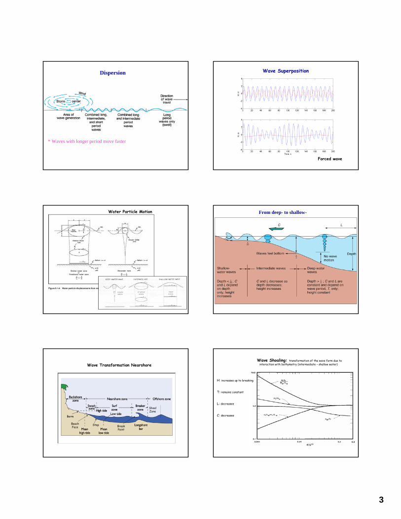
3
Dispersion
* Waves with longer period move faster
Wave Superposition
Forced wave
Water Particle Motion From deep- to shallow-
Wave Transformation Nearshore
Beach Face Break
Point
Berm
Shoal Zone
Step
Wave Shoaling: transformation of the wave form due to interaction with bathymetry (intermediate – shallow water)
H: increases up to breaking
T: remains constant
L: decreases
C: decreases

4
Breaker Height Index
Break Point: point at which wave form becomes unstable and breaks (water particles at the crest travel much faster/farther than water particles in the trough)
Breaker Index ~= 0.78
Note: Rough estimates of breaking wave height and depth can be calculated from deep water wave parameters (ie buoy measurements
Breaker Classification
Breaker Classification
Surf Similarity Parameter ~ Irribarren Number
Beach Slope Deep Water Wave Length
Deep Water Wave Height
Wave Setup & Setdown
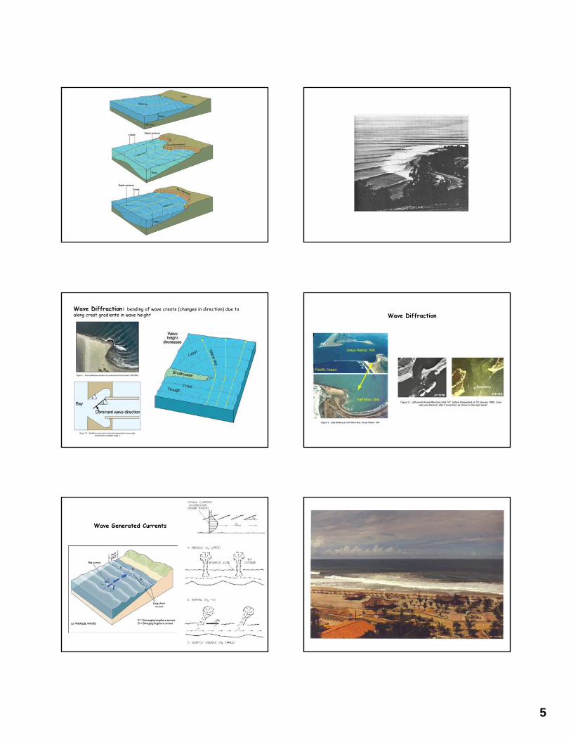
Wave Refraction: changes in the direction of wave propagation due to along crest variations in wave speed
Wave Rays: lines drawn perpendicular to the crest of the wave in the direction of wave propagation
Wave Refraction
Parallel Contours: refraction results in wave rays approaching normal to shoreline = (wave crests parallel to shoreline (a))
Submarine Ridge: focusing of wave energy toward the ridge (b)
Submarine Canyon: spreading of wave energy throughout the depression (c)
Headland: focusing of wave energy (d)
Ebb-Shoal:
(a)
(c)(b)
(d)
5
Wave Diffraction: bending of wave crests (changes in direction) due to along crest gradients in wave height Wave Diffraction
Wave Generated Currents

6
Seiches
Created By:
Wind
Tsunamis
Tidal Resonance
Potential Mechanisms
Geologic Events
Vertical fault movement
Mass wasting event
submarine landslides
collapsing volcanoes
Meteor Impact
http://walrus.wr.usgs.gov/tsunami/sumatraEQ/tectonics.html
The Dec 26, 2004 M=9.0 Sumatra earthquake occurred along a subduction zone in which the India and Australia plates to the west are being subducted beneath the Sunda plate and Burma microplateto the east.
Tsunamis
Satellite altimeters
450 mph in deep water
Satellite images of a coastal village in Banda Aceh, Indonesia
http://en.wikipedia.org/wiki/Image:Tsunami-2hrs.jpg
http://www.seed.slb.com/en/scictr/watch/living_planet/tsunami.htm
Wave Theories
ComplexityRange of Application
Wave Theories

7
Sediment Transport
Shearing forces and turbulence exerted on the sand grains by the overlying fluid are responsible for the movement of sediment
Sediment Transport Sediment can be transported in three distinct modes
1. Suspended Load: material is transported up into the water column and advected by currents (both wave and tide driven)
2. Bed Load: material is rolled/moved along the bottom without being suspended. Sand bars and bed forms are transported as bed load
3. Saltation: material is bounced along the bed
Grain Size – Velocity Relationship