CHAPTER 6: TRAFFIC COUNT DATABASE
76
CREATS Phase I Final Report Vol. IV: Urban Transport Database Chapter 6: TRAFFIC COUNT DATABASE 6 - 1 CHAPTER 6: TRAFFIC COUNT DATABASE 6.1 OVERVIEW Traffic count survey consists of the following two kinds of survey, traffic count on selected major corridors and traffic count at selected intersections and squares. The main objectives of the traffic count survey are to obtain the existing traffic volume on the major corridors, to analyze the existing traffic condition, to calibrate the existing OD matrices and to obtain turning movement of vehicles at major intersections and squares. Sixty five (65) locations were chosen for the traffic count survey on designated major corridors. These survey locations included major traffic generators such as the Airport, University and the vicinity of major tourist destinations. Traffic count at thirty three (33) locations, which were selected from major intersections and squares within the Study Area. Survey hours were basically 16 hours from 6:00 in the morning to 22:00 at night. However, survey hours at locations with high traffic volume were 24 hours from 6:00 in the morning to 6:00 in the morning on the following day. As for intersections, turning movement counts were carried out for 6 hours, 3 hours in morning peak and 3 hours in afternoon peak. Traffic count survey was performed on normal weekday from Monday through Wednesday excluding public holidays. Vehicle traffic count at 65 corridors was classified into 12 vehicle types as follows: • Passenger car. • Taxi (Cairo taxi and intercity taxi). • Public buses (CTA, GCBC, Governorate and intercity bus). • Public minibus. • Private buses (school bus, company and tourist bus). • Shared taxi. • Light commodity vehicle (pickup and vans). • 2 Axles truck. • 3 Axles truck. • Heavy truck (over three axles, trailer, semi-trailer). • 2-wheeler (motorcycle). • Others (military, police, ambulance and etc.).
Transcript of CHAPTER 6: TRAFFIC COUNT DATABASE

CREATS Phase I Final Report Vol. IV: Urban Transport Database Chapter 6: TRAFFIC COUNT DATABASE
6 - 1
CHAPTER 6: TRAFFIC COUNT DATABASE
6.1 OVERVIEW
Traffic count survey consists of the following two kinds of survey, traffic count on selected major corridors and traffic count at selected intersections and squares. The main objectives of the traffic count survey are to obtain the existing traffic volume on the major corridors, to analyze the existing traffic condition, to calibrate the existing OD matrices and to obtain turning movement of vehicles at major intersections and squares.
Sixty five (65) locations were chosen for the traffic count survey on designated major corridors. These survey locations included major traffic generators such as the Airport, University and the vicinity of major tourist destinations. Traffic count at thirty three (33) locations, which were selected from major intersections and squares within the Study Area.
Survey hours were basically 16 hours from 6:00 in the morning to 22:00 at night. However, survey hours at locations with high traffic volume were 24 hours from 6:00 in the morning to 6:00 in the morning on the following day. As for intersections, turning movement counts were carried out for 6 hours, 3 hours in morning peak and 3 hours in afternoon peak. Traffic count survey was performed on normal weekday from Monday through Wednesday excluding public holidays.
Vehicle traffic count at 65 corridors was classified into 12 vehicle types as follows:
• Passenger car. • Taxi (Cairo taxi and intercity taxi). • Public buses (CTA, GCBC, Governorate and intercity bus). • Public minibus. • Private buses (school bus, company and tourist bus). • Shared taxi. • Light commodity vehicle (pickup and vans). • 2 Axles truck. • 3 Axles truck. • Heavy truck (over three axles, trailer, semi-trailer). • 2-wheeler (motorcycle). • Others (military, police, ambulance and etc.).

CREATS Phase I Final Report Vol. IV: Urban Transport Database Chapter 6: TRAFFIC COUNT DATABASE
6 - 2
On the other hand, vehicle traffic count at 33 intersections was classified into only 6 vehicle types as follows:
• Passenger car and taxi. • Public and private buses. • Shared taxi and minibus. • Pickup and small truck. • 3 Axles truck and heavy truck • Others (military, police, ambulance and etc.).
The following outcomes are expected from the traffic count survey.
• Hourly traffic volumes by location, by direction and by vehicle type.
• Vehicle composition.
• Hourly fluctuation of traffic volume.
• Hourly turning movement of vehicles at peak hour bound
6.2 TRAFFIC COUNT DATABASE STRUCTURE
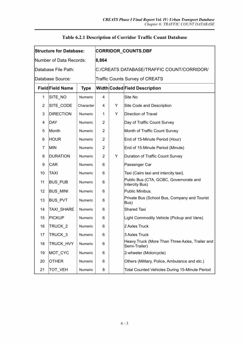
Three tables are required to describe either corridor count or intersection count. Tables 6.2.1 through 6.2.3 explains the database structure of traffic counts at 65 corridors, while Tables 6.2.4 through 6.2.6 describe the database structure of traffic counts at 33 intersections.
As for traffic count at corridors, site number, site code, direction of travel, survey date, counting period, counts of 12 vehicle types during 15-minute period are given in Table 6.2.1 followed by field code description in Tables 6.2.2 and 6.2.3.
A similar file structure is maintained for intersections database with less number of vehicle classes. The file structure is presented in Tables 6.2.4 through 6.2.6.
CREATS Phase I Final Report Vol. IV: Urban Transport Database Chapter 6: TRAFFIC COUNT DATABASE
6 - 3
Table 6.2.1 Description of Corridor Traffic Count Database
Structure for Database: CORRIDOR_COUNTS.DBF
Number of Data Records: 8,864
Database File Path: C:/CREATS DATABASE/TRAFFIC COUNT/CORRIDOR/
Database Source: Traffic Counts Survey of CREATS
Field Field Name Type Width Coded Field Description
1 SITE_NO Numeric 4 Site No
2 SITE_CODE Character 4 Y Site Code and Description
3 DIRECTION Numeric 1 Y Direction of Travel
4 DAY Numeric 2 Day of Traffic Count Survey
5 Month Numeric 2 Month of Traffic Count Survey
6 HOUR Numeric 2 End of 15-Minute Period (Hour)
7 MIN Numeric 2 End of 15-Minute Period (Minute)
8 DURATION Numeric 2 Y Duration of Traffic Count Survey
9 CAR Numeric 6 Passenger Car
10 TAXI Numeric 6 Taxi (Cairo taxi and intercity taxi).
11 BUS_PUB Numeric 6 Public Bus (CTA, GCBC, Governorate and Intercity Bus)
12 BUS_MINI Numeric 6 Public Minibus.
13 BUS_PVT Numeric 6 Private Bus (School Bus, Company and Tourist Bus)
14 TAXI_SHARE Numeric 6 Shared Taxi
15 PICKUP Numeric 6 Light Commodity Vehicle (Pickup and Vans)
16 TRUCK_2 Numeric 6 2 Axles Truck
17 TRUCK_3 Numeric 6 3 Axles Truck
18 TRUCK_HVY Numeric 6 Heavy Truck (More Than Three Axles, Trailer and Semi-Trailer)
19 MOT_CYC Numeric 6 2-wheeler (Motorcycle)
20 OTHER Numeric 6 Others (Military, Police, Ambulance and etc.)
21 TOT_VEH Numeric 8 Total Counted Vehicles During 15-Minute Period

CREATS Phase I Final Report Vol. IV: Urban Transport Database Chapter 6: TRAFFIC COUNT DATABASE
6 - 4
Table 6.2.2 Field Code Definition of Corridor Traffic Count Database
Field Codes Used in Database: CORRIDOR_COUNTS.DBF
Field Field Name Field Description Code Field Code Description
2 SITE_CODE Site Code and Description See Site Description File:
CORRIDOR_SITES.DBF
3 DIRECTION Direction of Travel See Site Description File:
CORRIDOR_SITES.DBF
8 DURATION Duration of Traffic Count Survey16 Traffic Count Survey for 16-Hour
Period
24 Traffic Count Survey for 24-Hour
Period
Table 6.2.3 Description of Corridor Traffic Count Database (Count Sites)
Structure for Database: CORRIDOR_SITES.DBF
Number of Data Records: 130
Database File Path: C:/CREATS DATABASE/TRAFFIC COUNT/CORRIDOR/
Database Source: Traffic Counts Survey of CREATS
Field Field Name Type Width Coded Field Description
1 COUNT_TYPE Character 20 Type of Traffic Count
2 SITE_NO Numeric 3 Site No
3 SITE_CODE Character 5 Site Code and Description
4 DIRECTION Numeric 1 Direction of Travel Code
5 DIR_TO Character 24 Direction of Travel Description
6 DURATION Numeric 2 Duration of Traffic Count Survey
7 DAY_WEEK Character 3 Day of the Week
8 SRVY_DAY Numeric 2 Survey Day
9 SRVY_MONTH Numeric 2 Survey Month
10 SRVY_YEAR Numeric 4 Survey Year
11 SITE_NAME Character 65 Name of Traffic Count Site
CREATS Phase I Final Report Vol. IV: Urban Transport Database Chapter 6: TRAFFIC COUNT DATABASE
6 - 5
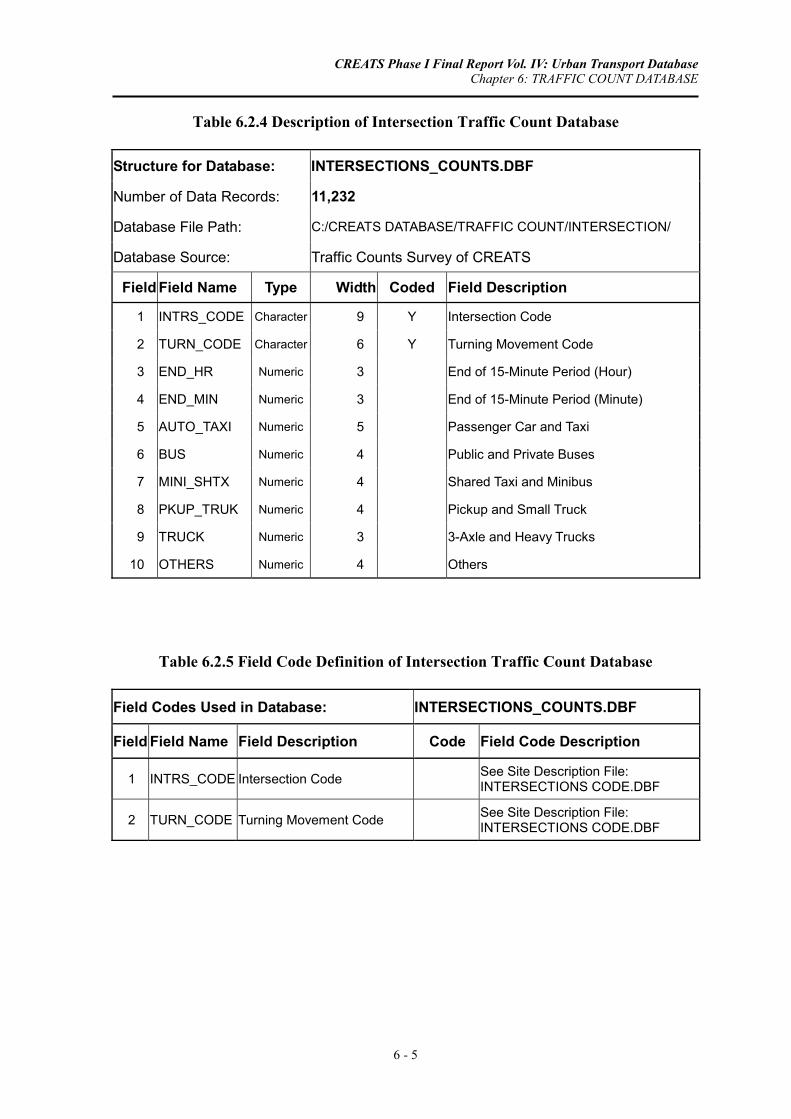
Table 6.2.4 Description of Intersection Traffic Count Database
Structure for Database: INTERSECTIONS_COUNTS.DBF
Number of Data Records: 11,232
Database File Path: C:/CREATS DATABASE/TRAFFIC COUNT/INTERSECTION/
Database Source: Traffic Counts Survey of CREATS
Field Field Name Type Width Coded Field Description
1 INTRS_CODE Character 9 Y Intersection Code
2 TURN_CODE Character 6 Y Turning Movement Code
3 END_HR Numeric 3 End of 15-Minute Period (Hour)
4 END_MIN Numeric 3 End of 15-Minute Period (Minute)
5 AUTO_TAXI Numeric 5 Passenger Car and Taxi
6 BUS Numeric 4 Public and Private Buses
7 MINI_SHTX Numeric 4 Shared Taxi and Minibus
8 PKUP_TRUK Numeric 4 Pickup and Small Truck
9 TRUCK Numeric 3 3-Axle and Heavy Trucks
10 OTHERS Numeric 4 Others
Table 6.2.5 Field Code Definition of Intersection Traffic Count Database
Field Codes Used in Database: INTERSECTIONS_COUNTS.DBF
Field Field Name Field Description Code Field Code Description
1 INTRS_CODE Intersection Code See Site Description File: INTERSECTIONS CODE.DBF
2 TURN_CODE Turning Movement Code See Site Description File: INTERSECTIONS CODE.DBF

CREATS Phase I Final Report Vol. IV: Urban Transport Database Chapter 6: TRAFFIC COUNT DATABASE
6 - 6
Table 6.2.6 Description of Intersection Traffic Count Database (Count Sites)
Structure for Database: INTERSECTIONS_CODE.DBF
Number of Data Records: 467
Database File Path: C:/CREATS DATABASE/TRAFFIC COUNT/INTERSECTION/
Database Source: Traffic Counts Survey of CREATS
Field Field Name Type Width Coded Field Description
1 INTRS_CODE Character 3 Intersection Code
2 INTRS_NAME Character 58 Intersection Name
3 SRVY_DAY Numeric 2 Survey Day
4 SRVY_MONTH Numeric 2 Survey Month
5 SRVY_YEAR Numeric 4 Survey Year
6 DAY_WEEK Character 3 Day of Week
7 TURN_CODE Character 6 Turning Movement Code
8 TURN_FROM Character 29 Turning Movement: From Direction
9 TURN_TO Character 29 Turning Movement: To Direction

CREATS Phase I Final Report Vol. IV: Urban Transport Database Chapter 7: PUBLIC TRANSPORT DATABASE
7 - 1
CHAPTER 7: PUBLIC TRANSPORT DATABASE
7.1 OVERVIEW
Public transport services in the Study Area may be categorized as consisting of two generic groupings; namely, formal services and informal services.
• Formal urban public transport services are provided by the public sector. The CTA (Cairo Transport Authority), and its subsidiary GCBC (Greater Cairo Bus Company), provide bus services throughout Greater Cairo (GC) using standard-sized buses and minibuses. The CTA also operates light rail services (tram and Heliopolis metro) as well as the water-borne Nile ferries. Other major elements of the formal sector providing urban public transport services include the Cairo Metro Organization (CMO) and the Egyptian National Railways (ENR). In principal, the formal sector is regulated and information regarding routes, lines, ridership and operating parameters is generally available, although not uniformly in terms of scope and content across all modes.
• The informal sector consists of shared taxis (microbuses) and, in some instances, cooperative minibuses. Shared taxi service is provided by the private sector using microbuses with typical capacities of 11 or 14 seats; however, recently, this mandate has been expanded by Giza Governorate and services are being provided via private-sector cooperative minibuses. Previous studies confirm that the shared taxi mode has evolved as a dominant means of road-based public transport in Cairo. Unfortunately, for this very important mode, only fragmented and, at times, uncertain information exists. Data relating to patronage are lacking. CREATS surveys therefore proved to be the major source of data for informal sector modes.
7.2 CTA ROUTES DATABASE
7.2.1 Overview
Cairo Transport Authority (CTA) route database is built using the information collected from CTA. The characteristics of around 540 bus routes were specified including fleet and operational data. Data of Cairo Transport Authority, Greater Cairo Bus Company were combined in one route database as shown below.

CREATS Phase I Final Report Vol. IV: Urban Transport Database Chapter 7: PUBLIC TRANSPORT DATABASE
7 - 2
7.2.2 CTA RUOTES Database Structure
Bus route database is described in Tables 7.2.1, which comprises bus type, line type, line number, line mark, route description, bus garage name, number of working buses, average route length (kilometers), peak headway (minutes), average speed (KPH), average number of passengers per day, average number of passengers per trip, number of stops in one direction, Moniemum and maximum fare.
The bus type is further explained in Table 7.2.2, in which four bus types are defined:
• Cairo Transport Authority (CTA) bus.
• Cairo Transport Authority (CTA) minibus.
• Cairo Transport Authority (CTA) school bus.
• Greater Cairo Bus Company (GCBC) bus.
7.3 ON-BOARD SURVEY DATABASE
7.3.1 Overview
Two shared taxi surveys: the “Terminal Operation Characteristics Survey” and “Route Characteristics Survey". The database structure of the later survey is addressed in this section, while the former is discussed in Section 7.4. The route characteristics survey was carried out for shared taxi, cooperative minibus and black/white taxi.
• The route characteristics survey for 503 shared taxi lines was conducted using 15 surveyors, who were asked to ride microbuses on the different lines throughout the day (from 06:00 to 24:00 hours). Data noted includes, among others, route alignment and patronage on/off patterns for each line. Some 2,400 bus journeys were surveyed.
• As for the route structure of Cooperative Minibus, a team of surveyors was assigned to ride a representative series of routes to record route alignment and patronage on/off patterns. Execution was similar to that employed for the shared taxi route characteristics survey.
• Some 100 black/white taxi drivers were selected to participate in this survey based on their desire to participate and reading/writing abilities. Each driver was asked to maintain a daily log of commercial activities. Noted information included time of shift, location of home garage as well as frequency and distance of fare passenger trips.

CREATS Phase I Final Report Vol. IV: Urban Transport Database Chapter 7: PUBLIC TRANSPORT DATABASE
7 - 3
7.3.2 On-Board Survey Database Structure
Most of CREATS databases are given a unified file format with an extension of (DBF). In some cases, it was difficult to apply this rule such as route characteristics survey. Instead a spreadsheet (Excel 2000 format) is used to describe the survey results. In such a case, the file structure is described using row number and column letter. For instance, the upper part of Table 7.3.1 keeps the same standard file format, while the lower part is divided into 4 columns labeled as Column, Type, Coded and Column Label, respectively.
The database of route characteristics survey of shared taxis is saved as Excel format with an extension of (XLS), which includes survey date, survey shift time, counting period, number of seats, number of passengers, route description and fare. For each stop during the journey, some information have to be noted:
• Stop number. • Arrival time at the stop. • Number of boarding passengers. • Number of alighting passengers. • Departure time from the stop. • Reason of delay.
Therefore, column M through column R, representing information of one stop, was repeated for the next stops on the surveyed route of shared taxi.
The description of field codes is shown in Table 7.3.2 with only three items to be elaborated, weekday, shift time and reason of delay.
The same file structure was utilized for the route characteristics survey of cooperative minibus and black/white taxi as shown in Tables 7.3.3 and 7.3.4.
The file structure of black/white taxi database is a little bit different from previous two modes although it kept the same concept as shown in Tables 7.3.5 and 7.3.6. Kilometer-counter reading at trip start and trip end was observed in addition to starting time and ending time of each trip. The trip origin and trip destination were also included in the collected data.
7.4 SHARED TAXI TERMINAL SURVEY DATABASE
7.4.1 Overview
Because of the lack of the operational data on shared taxi in any recent study, all information was collected through field surveys. This service started in GC in the late seventies and early eighties. In Greater Cairo Region, there are three Governorates (Cairo, Giza and Qalyobeya) and also three Traffic Police Directorates, one for each Governorate. Because of some operational problems, different steps were taken to improve the output of this service. Cairo Governorate, for example, took a decision to give the CTA direct supervision of this service for the routes registered in Cairo.

CREATS Phase I Final Report Vol. IV: Urban Transport Database Chapter 7: PUBLIC TRANSPORT DATABASE
7 - 4
In Giza Goveronrate, Giza City Council is in charge of the shared taxi service. These two authorities were contacted to collect the available data Abut the service. Qalyobeya Governorate is organizing this service through the Secretary General of the Governorate. However, most of the Qalyobeya Governorate services are operated locally outside Greater Cairo area.
Two shared taxi surveys, namely “Terminal Operation Characteristics Survey” and “Route Characteristics Survey" were carried out to collect as much accurate and informative data as possible regarding the operation of shared taxi.
In addition to the route characteristics survey, a terminal operation survey was carried out to collect as much accurate and informative data as possible to identify the operational characteristic of this transport mode.
This survey required a team consisted of more than 600 surveyors divided into three groups. Each group had a supervisor, with work extending over three shifts for 18 hours (between 06:00 and 24:00). A total of 149 terminals were included in the survey framework, at which around 113,000 shared taxi departures were monitored.
7.4.2 Shared Taxi Terminal Survey Database Structure
The database of shared taxi terminal survey utilizes the standard file format as shown in Tables 7.4.1 and 7.4.2. The database includes survey date, terminal code, terminal name, shared taxi type (model), number of seats, destination name, departure time and number of passengers at departure time.
7.5 PUBLIC TRANSPORT PASSENGER SURVEY DATABASE
7.5.1 Overview
The objective of the public transport passenger survey (PTPS) is to collect additional information on public transport regarding:
• Passengers characteristics per mode by gender, occupation, age, or status for non working people;
• Trips characteristics by purpose, average waiting time, number of used modes from and origin destination trips, access modes to the station;
• Fare characteristics by trip cost, fare type distribution and fare pass period duration by mode;
• Qualitative approach of what passengers are thinking Abut quality of the public transport offered services; and,
• Willingness of passengers to pay for public transport service improvements.

CREATS Phase I Final Report Vol. IV: Urban Transport Database Chapter 7: PUBLIC TRANSPORT DATABASE
7 - 5
The public transport modes surveyed were CMO Metro, CTA buses, shared taxis and ENR trains (suburban rail). The field work for the survey was conducted during the period from October 8, 2001 to November 8, 2001 by a team of 15 trained engineers.
A total of 6,125 valid interviews forms have been completed for the four modes. A total of 105 survey locations have been selected for the four selected public transport modes. The survey locations for individual modes are 23 metro stations, 30 bus stations, 40 shared taxi stations and 12 ENR train stations. The distribution of interviewed passengers among different transport modes is shown below.
Mode No. of Locations Sample Size CMO Metro 23 1,780
CTA Bus 30 1,689
Shared Taxi 40 2,274
ENR Rail 12 382
In the case of the metro, bus, and shared taxi modes, passengers were interviewed before boarding. For the rail mode, the survey was conducted within the train going in direction of Greater Cairo, because of the difficulty of finding passengers in some rail stations outside Cairo center.
7.5.2 Public Transport Passenger Survey Database Structure
Public transport passenger survey (PTPS) is housed in a database file, which consists of 1,125 records and follows the standard file structure as shown in Tables 7.5.1 and 7.5.2. A long list of data were included in these files such as transport mode, station, survey date, gender, age, occupation, status for non-working person, trip purpose, trip origin, trip destination, fare type, pass period, ticket/pass cost and employer reimbursement for travel cost. In addition, the passenger was asked to evaluate some measures of level of service such as speed, comfort, headway, crowdness and safety. The willingness to pay extra cost for better service was also reported.
The location names for various transport modes are specified in Table 7.5.2, which describe the field codes of Table 7.5.1.

CREATS Phase I Final Report Vol. IV: Urban Transport Database Chapter 7: PUBLIC TRANSPORT DATABASE
7 - 6
Table 7.2.1 Description of CTA Routes Database
Structure for Database: CTA ROUTES DATA.DBF
Number of Data Records: 542
Database File Path: C:/CREATS DATABASE/PUBLIC TRANSPORT/CTA ROUTES/
Database Source: Cairo Transport Authority (CTA) - April 2001
Field Field Name Type Width Coded Field Description
1 BUS_TYPE Numeric 2 Y Bus Type
2 LINE_TYPE Character 9 Line Type
3 LINE_NO Numeric 7 Line Number
4 LINE_MARK Character 2 Line Mark
5 MAIN_ROUT Character 56 Main Route Description
6 GARAGE Character 14 Garage Name
7 BUS_WORK Numeric 4 No. of Working Buses
8 ROUT_KM Numeric 7 Average Length (Km)
9 HEADWAY Numeric 6 Peak Headway (Min)
10 SPEED Numeric 6 Average Speed (KPH)
11 PASS_DAY Numeric 7 Average No. of Passengers per Day
12 PASS_TRIP Numeric 5 Average No. of Passengers per Trip
13 STOP_NO Numeric 5 No. of Stops (One Direction)
14 FARE_MIN Numeric 5 Moniemum or Flat Fare (Pt)
15 FARE_MAX Numeric 4 Maximum Fare (Pt)
Table 7.2.2 Field Code Definition of CTA Routes Database
Field Codes Used in Database: CTA ROUTES DATA.DBF
Field Field Name Field Description Code Field Code Description
1 BUS_TYPE Bus Type 1 Cairo Transport Authority (CTA) Bus
2 Cairo Transport Authority (CTA) Minibus
3 Cairo Transport Authority (CTA) School Bus
4 Greater Cairo Bus Company (GCBC) Bus

CREATS Phase I Final Report Vol. IV: Urban Transport Database Chapter 7: PUBLIC TRANSPORT DATABASE
7 - 7
Table 7.3.1 Description of On-Board Survey Database (Shared Taxi)
Structure for Database: ON-BOARD RIDERSHIP SURVEY.XLS
Spreadsheet Name: Shared Taxi
Number of Data Records: 2,429
Database File Path: C:/CREATS DATABASE/PUBLIC TRANSPORT/ON-BOARD/
Database Source: On-board Ridership Survey of CREATS
Column Type Coded Column Label
A Numeric Date: Day
B Numeric Date: Month
C Numeric Y Week Day
D Numeric Y Shift Time
E Time Counting Period: From
F Time Counting Period: To
G Numeric No of seats
H Numeric No of Passengers
I Character Route: From
J Character Route: To
K Character Governorate
L Numeric Fare (Pt)
M Numeric Stop No.
N Time Arrival Time at the Stop
O Numeric Boarding: Off
P Numeric Boarding: On
Q Time Departure Time from the stop
R Numeric Y Reason For Delay
Note: Columns M through R are repeated for next stops during an on-board trip

CREATS Phase I Final Report Vol. IV: Urban Transport Database Chapter 7: PUBLIC TRANSPORT DATABASE
7 - 8
Table 7.3.2 Field Code Definition of On-Board Survey Database (Shared Taxi)
Column Codes Used in Spreadsheet: ON-BOARD RIDERSHIP SURVEY.XLS
Column Column Label Description Code Column Code Description
C Week Day Day of the Week 1 Saturday
2 Sunday
3 Monday
4 Tuesday
5 Wednesday
6 Thursday
7 Friday
D Shift Time Survey Shift Code 1 06 AM - 12 PM
2 12 PM - 06 PM
3 06 PM - 12 AM
R Reason of Delay Delay Reason 1 Passenger On/Off
2 Traffic Light
3 Accident
4 Traffic Congestion
5 Pedestrian Crossing
6 Others

CREATS Phase I Final Report Vol. IV: Urban Transport Database Chapter 7: PUBLIC TRANSPORT DATABASE
7 - 9
Table 7.3.3 Description of On-Board Survey Database (Cooperative Minibus)
Structure for Database: ON-BOARD RIDERSHIP.XLS
Spreadsheet Name: Coop-Minibus
Number of Data Records: 13
Database File Path: C:/CREATS DATABASE/PUBLIC TRANSPORT/ON-BOARD/
Database Source: On-board Ridership Survey of CREATS
Column Type Coded Column Label
A Numeric Date: Day
B Numeric Date: Month
C Numeric Y Week Day
D Numeric Y Shift Time
E Time Counting Period: From
F Time Counting Period: To
G Numeric No of seats
H Numeric No of Passengers
I Character Route: From
J Character Route: To
K Character Governorate
L Numeric Fare (Pt)
M Numeric Stop No.
N Time Arrival Time at the Stop
O Numeric Boarding: Off
P Numeric Boarding: On
Q Time Departure Time from the stop
R Numeric Y Reason For Delay
Note: Columns M through R are repeated for next stops during an on-board trip
CREATS Phase I Final Report Vol. IV: Urban Transport Database Chapter 7: PUBLIC TRANSPORT DATABASE
7 - 10
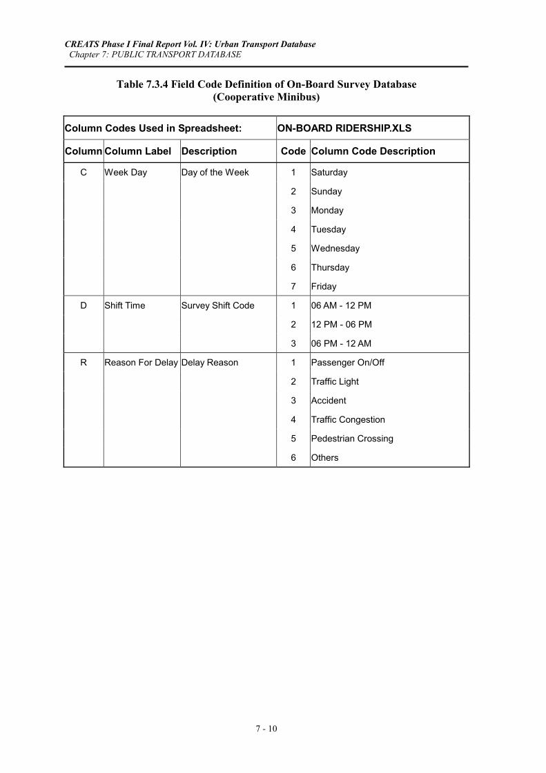
Table 7.3.4 Field Code Definition of On-Board Survey Database (Cooperative Minibus)
Column Codes Used in Spreadsheet: ON-BOARD RIDERSHIP.XLS
Column Column Label Description Code Column Code Description
C Week Day Day of the Week 1 Saturday
2 Sunday
3 Monday
4 Tuesday
5 Wednesday
6 Thursday
7 Friday
D Shift Time Survey Shift Code 1 06 AM - 12 PM
2 12 PM - 06 PM
3 06 PM - 12 AM
R Reason For Delay Delay Reason 1 Passenger On/Off
2 Traffic Light
3 Accident
4 Traffic Congestion
5 Pedestrian Crossing
6 Others

CREATS Phase I Final Report Vol. IV: Urban Transport Database Chapter 7: PUBLIC TRANSPORT DATABASE
7 - 11
Table 7.3.5 Description of On-Board Survey Database (Black and White Taxi)
Structure for Database: ON-BOARD RIDERSHIP.XLS
Spreadsheet Name: BW Taxi
Number of Data Records: 107
Database File Path: C:/CREATS DATABASE/PUBLIC TRANSPORT/ON-BOARD/
Database Source: On-board Ridership Survey of CREATS
Column Type Coded Column Label A Numeric Date: Day B Numeric Date: Month C Time Shift Starting Time D Numeric Location: Home E Numeric Location: Private Garage F Numeric Location: Public Garage G Numeric Counter Reading At The Beginning (Km) H Time Shift Ending Time I Numeric Location: Home J Numeric Location: Private Garage K Numeric Location: Public Garage L Numeric Counter Reading At End (Km) M Numeric Trip No. N Numeric Y Origin O Time Starting Time P Numeric Counter Reading At The Beginning (Km) Q Numeric Y Destination R Numeric No. Of Passengers S Time Ending Time T Numeric Counter Reading At End (Km)
Note: Columns M through T are repeated for next trips
Table 7.3.6 Field Code Definition of On-Board Survey Database (Black and White Taxi)
Column Codes Used in Spreadsheet: ON-BOARD RIDERSHIP.XLS
Column Column Label Description Code Column Code Description
N Origin Qism Origin Code at which Passenger Gets On Taxi See Equivalence Table …..
Q Destination Destination Qism Code at which Passenger Gets Off Taxi See Equivalence Table …..

CREATS Phase I Final Report Vol. IV: Urban Transport Database Chapter 7: PUBLIC TRANSPORT DATABASE
7 - 12
Table 7.4.1 Description of Shared Taxi Terminal Survey Database
Structure for Database: SHTX_TERMINAL.DBF
Number of Data Records: 113,028
Database File Path: C:/CREATS DATABASE/PUBLIC TRANSPORT/SHTX TERMINAL/
Database Source: Terminal Operation Characteristics Survey of CREATS
Field Field Name Type Width Coded Field Description 1 SRVY_DAY Numeric 2 Survey Day 2 SRVY_MONTH Numeric 2 Survey Month 3 DAY_WEEK Numeric 2 Y Day of the Week 4 SHIFT_CODE Numeric 2 Y Survey Shift Code 5 HR_FROM Numeric 3 Start Hour of Survey Shift 6 MIN_FROM Numeric 3 Start Minute of Survey Shift 7 HR_TO Numeric 3 End Hour of Survey Shift 8 MIN_TO Numeric 3 End Minute of Survey Shift 9 TRMNL_CODE Numeric 4 Terminal Code
10 TRMNL_NAME Character 20 Terminal Name 11 PLATE_NO Numeric 9 Plate No of Surveyed Shared Taxi
12 GVRN Character 13 Governorate Name in which the Shared Taxi is Registered
13 VEH_TYPE Character 15 Vehicle Type (Model) 14 NO_SEATS Numeric 4 No of Seats per Shared Taxi 15 DES_NAME Character 28 Destination Name 16 DPRT_HR Numeric 3 Departure Hour 17 DPRT_MIN Numeric 3 Departure Minute 18 NO_PASS Numeric 4 No of Passenger at Departure Time
Table 7.4.2 Field Code Definition of Shared Taxi Terminal Survey Database
Field Codes Used in Database: SHTX_TERMINAL.DBF
Field Field Name Field Description Code Field Code Description 3 DAY_WEEK Day of the Week 1 Saturday 2 Sunday 3 Monday 4 Tuesday 5 Wednesday 6 Thursday 7 Friday 4 SHIFT_CODE Survey Shift Code 1 06 AM - 12 PM 2 12 PM - 06 PM 3 06 PM - 12 AM

CREATS Phase I Final Report Vol. IV: Urban Transport Database Chapter 7: PUBLIC TRANSPORT DATABASE
7 - 13
Table 7.5.1 Description of Public Transport Passenger Survey Database
Structure for Database: PT_PASSENGERS.DBF
Number of Data Records: 6,125
Database File Path: C:/CREATS DATABASE/PUBLIC TRANSPORT/PT PASSENGER/
Database Source: Public Transport Passengers Survey of CREATS
Field Field Name Type Width Coded Field Description
1 SMPL_NO Numeric 6 Sample ID
2 MODE_CODE Character 2 Y Mode Code
3 SATATION Character 4 Y Station Code
4 DATE Date 8 Survey Date
5 TIME_HR Numeric 2 Survey Time (Hr)
6 SEX Numeric 1 Y Gender
7 AGE Numeric 1 Y Age
8 OCCUP Numeric 2 Y Occupation (Working Persons)
9 NW_STATS Numeric 1 Y Status of Non-Working Person
10 TRP_PURP Numeric 1 Y Trip Reason
11 QISM_ORG Numeric 4 Y Qism Code of Origin Station
12 SHKH_ORG Numeric 2 Y Shiakha Code of Origin Station
13 QISM_DES Numeric 4 Y Qism Code of Destination Station
14 SHKH_DES Numeric 2 Y Shiakha Code of Destination Station
15 MODE1 Numeric 2 Y Transport Mode 1
16 FARE_TYP1 Numeric 1 Y Fare Type of Mode 1
17 PASS_TIM1 Numeric 1 Y Pass Period of Mode 1
18 FARE_CST1 Numeric 6 Ticket/Pass Cost of Mode 1 (Piasters)
19 EMPL_SHAR1 Numeric 2 Y Employer Reimbursement of Mode 1
20 MODE2 Numeric 2 Y Transport Mode 2
21 FARE_TYP2 Numeric 1 Y Fare Type of Mode 2
22 PASS_TIM2 Numeric 1 Y Pass Period of Mode 2
23 FARE_CST2 Numeric 6 Ticket/Pass Cost of Mode 2 (Piasters)
24 EMPL_SHAR2 Numeric 2 Y Employer Reimbursement of Mode 2
25 MODE3 Numeric 3 Y Transport Mode 3
26 FARE_TYP3 Numeric 2 Y Fare Type of Mode 3
27 PASS_TIM3 Numeric 2 Y Pass Period of Mode 3
28 FARE_CST3 Numeric 6 Ticket/Pass Cost of Mode 3 (Piasters)
29 EMPL_SHAR3 Numeric 2 Y Employer Reimbursement of Mode 3

CREATS Phase I Final Report Vol. IV: Urban Transport Database Chapter 7: PUBLIC TRANSPORT DATABASE
7 - 14
Table 7.5.1 Description of Public Transport Passenger Survey Database (Continued)
Structure for Database: PT_PASSENGERS.DBF
Number of Data Records: 6,125
Database File Path: C:/CREATS DATABASE/PUBLIC TRANSPORT/PT PASSENGER/
Database Source: Public Transport Passengers Survey of CREATS
Field Field Name Type Width Coded Field Description
30 MODE4 Numeric 2 Y Transport Mode 4
31 FARE_TYP4 Numeric 1 Y Fare Type of Mode 4
32 PASS_TIM4 Numeric 1 Y Pass Period of Mode 4
33 FARE_CST4 Numeric 6 Ticket/Pass Cost of Mode 4 (Piasters)
34 EMPL_SHAR4 Numeric 1 Y Employer Reimbursement of Mode 4
35 WAIT_TIME Numeric 2 Average Waiting Time of Current Mode (Minutes)
36 MODE_ID Numeric 1 Mode Serial of Current Mode
37 ACS_SIGN Numeric 1 Y Accessibility to Terminal/Station/Stop: Signs
38 ACS_WALK Numeric 1 Y Accessibility to Terminal/Station/Stop: Pedestrian
39 ACS_CHNG Numeric 1 Y Accessibility to Terminal/Station/Stop: Intermodal
40 ACS_FEDR Numeric 1 Y Accessibility to Terminal/Station/Stop: Feeder
41 ACS_DIST Numeric 1 Y Accessibility to Terminal/Station/Stop: Distance
42 PLT_SIGN Numeric 1 Y Platform Services for Metro & ENR: Directions
43 PLT_WALK Numeric 1 Y Platform Services for Metro & ENR: Pedestrians
44 PLT_GIUD Numeric 1 Y Platform Services for Metro & ENR: Instructions
45 PLT_TCKT Numeric 1 Y Platform Services for Metro & ENR: Ticket
46 SRVC_SPEED Numeric 1 Y Transport Service: Speed
47 SRVC_CMFRT Numeric 1 Y Transport Service: Comfort
48 SRVC_HDWY Numeric 1 Y Transport Service: Headway
49 SRVC_CROWD Numeric 1 Y Transport Service: Crowdness
50 SRVC_SAFTY Numeric 1 Y Transport Service: Safety
51 WILNG_FARE Numeric 1 Y Willingness to Pay Extra for Better Service
52 WILNG_WALK Numeric 1 Y Willingness to Walk Longer

CREATS Phase I Final Report Vol. IV: Urban Transport Database Chapter 7: PUBLIC TRANSPORT DATABASE
7 - 15
Table 7.5.2 Field Code Definition of Public Transport Passenger Survey Database
Field Codes Used in Database: PT_PASSENGERS.DBF
Field Field Name Field Description Code Field Code Description
2 MODE_CODE Mode Code B Bus M Metro R ENR Train S Shared Taxi
3 SATATION Station Code B01 Shobra Hay Gharb B02 Shobra Hay Sharq B03 Mazalat B04 Qanater B05 Mesala B06 Abaseya B07 Nozha El Gedeeda B08 Madinat El Salam (Spiko) B09 Sooq El Oboor B10 Madinat El Oboor B11 Matar B12 Zahraa Madinat Nasr B13 Ramsees B14 Ataba B15 Abdel Moniem Ryad B16 Darasa B17 Sayeda Zeinab B18 Basateen B19 Qalaa B20 Helwan B21 Qatameya B22 Waraq al Hadara B23 Imbaba B24 Libanon Sq. B25 Boolaq El Dakroor B26 Giza Sq. B27 Moneeb B28 Kahraba El Ahram B29 6th of October City B30 Badrasheen

CREATS Phase I Final Report Vol. IV: Urban Transport Database Chapter 7: PUBLIC TRANSPORT DATABASE
7 - 16
Table 7.5.2 Field Code Definition of Public Transport Passenger Survey Database (Continued)
Field Codes Used in Database: PT_PASSENGERS.DBF
Field Field Name Field Description Code Field Code Description M01 Marg on Metro Line 1 M02 Ezbet El Nakhl on Metro Line 1 M03 Ain Shams on Metro Line 1 M04 Matareya on Metro Line 1 M05 Saraya El Qoba on Metro Line 1 M06 Kobry El Qoba on Metro Line 1
M07 Mobarak (Ramsees) on Metro Line 1 and Metro Line 2
M08 Gamal Abdel Naser on Metro Line 1
M09 Sadat (Tahreer) on Metro Line 1 and Metro Line 2
M10 Saad Zaghlool on Metro Line 1 M11 Sayeda Zeinab on Metro Line 1 M12 Dar El Salam on Metro Line 1 M13 Maadi on Metro Line 1 M14 Wady Hoof on Metro Line 1 M15 Ain Helwan on Metro Line 1 M16 Helwan on Metro Line 1 M17 Shobra on Metro Line 2 M18 Rood El Farag on Metro Line 2 M19 Ataba on Metro Line 2 M20 Bohooth on Metro Line 2 M21 Cairo University on Metro Line 2 M22 Giza on Metro Line 2 M23 Giza Suburbs on Metro Line 2 R01 Giza Suburbs R02 Ramsees R03 Shobra El Kheima R04 Ain Shams R05 Marg al Gadeed R06 Qalyob R07 Shebeen El Qanater R08 Ayat R09 Giza R10 Marg R11 Nikla R12 Manashy
CREATS Phase I Final Report Vol. IV: Urban Transport Database Chapter 7: PUBLIC TRANSPORT DATABASE
7 - 17
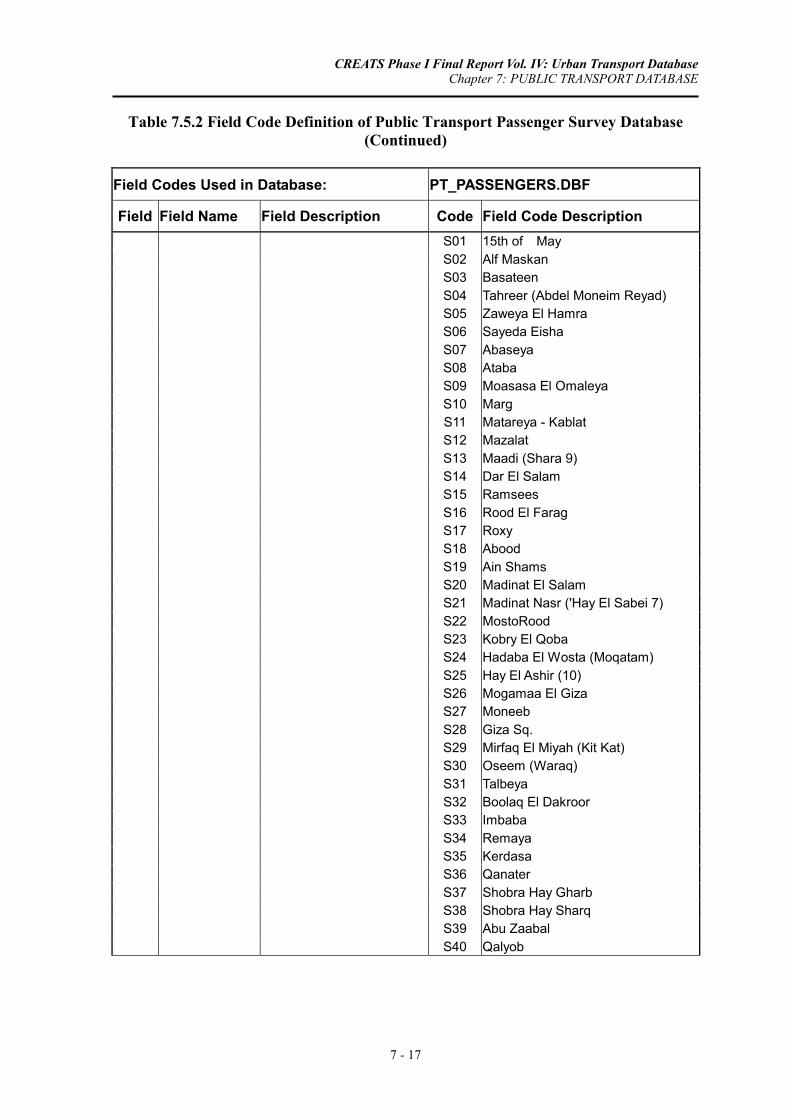
Table 7.5.2 Field Code Definition of Public Transport Passenger Survey Database (Continued)
Field Codes Used in Database: PT_PASSENGERS.DBF
Field Field Name Field Description Code Field Code Description S01 15th of May S02 Alf Maskan S03 Basateen S04 Tahreer (Abdel Moneim Reyad) S05 Zaweya El Hamra S06 Sayeda Eisha S07 Abaseya S08 Ataba S09 Moasasa El Omaleya S10 Marg S11 Matareya - Kablat S12 Mazalat S13 Maadi (Shara 9) S14 Dar El Salam S15 Ramsees S16 Rood El Farag S17 Roxy S18 Abood S19 Ain Shams S20 Madinat El Salam S21 Madinat Nasr ('Hay El Sabei 7) S22 MostoRood S23 Kobry El Qoba S24 Hadaba El Wosta (Moqatam) S25 Hay El Ashir (10) S26 Mogamaa El Giza S27 Moneeb S28 Giza Sq. S29 Mirfaq El Miyah (Kit Kat) S30 Oseem (Waraq) S31 Talbeya S32 Boolaq El Dakroor S33 Imbaba S34 Remaya S35 Kerdasa S36 Qanater S37 Shobra Hay Gharb S38 Shobra Hay Sharq S39 Abu Zaabal S40 Qalyob

CREATS Phase I Final Report Vol. IV: Urban Transport Database Chapter 7: PUBLIC TRANSPORT DATABASE
7 - 18
Table 7.5.2 Field Code Definition of Public Transport Passenger Survey Database (Continued)
Field Codes Used in Database: PT_PASSENGERS.DBF
Field Field Name Field Description Code Field Code Description
6 SEX Gender 1 Male 2 Female 7 AGE Age 1 < 20 /years 2 21 - 40 years 3 41 - 60 years 4 More than 60 years 9 No Answer 8 OCCUP Occupation (Working Persons) 1 Administration 2 Professional 3 Tech/ Assist 4 Clerk 5 Sales/Service 6 Farmer/fisher 7 Craftsman 8 Production 9 Unskilled 10 Student 11 Housewife 12 Retired 13 Jobless 14 Others 99 No Answer 9 NW_STATS Status of Non-Working Person 1 Student (Primary) 2 Student (Secondary) 3 Student (High School) 4 Student (Technical) 5 Student (University) 6 Housewife 7 Retired Person 8 Jobless 9 Working Person or No Answer
10 TRP_PURP Trip Reason 1 To/From Work 2 To/From School 3 To/From Others 9 No Answer
11 QISM_ORG Qism Code of Origin Station See Equivalence Table ….. 12 SHKH_ORG Shiakha Code of Origin Station See Equivalence Table ….. 13 QISM_DES Qism Code of Destination Station See Equivalence Table …..
14 SHKH_DES Shiakha Code of Destination Station See Equivalence Table …..

CREATS Phase I Final Report Vol. IV: Urban Transport Database Chapter 7: PUBLIC TRANSPORT DATABASE
7 - 19
Table 7.5.2 Field Code Definition of Public Transport Passenger Survey Database (Continued)
Field Codes Used in Database: PT_PASSENGERS.DBF
Field Field Name Field Description Code Field Code Description
15 MODE1 Transport Mode 1 1 On-Foot 20 MODE2 Transport Mode 2 2 Bicycle 25 MODE3 Transport Mode 3 3 Motorcycle 30 MODE4 Transport Mode 4 4 Private Car Driver
5 Private Car Passenger 6 Pickup for Passengers 7 Taxi 8 Shared Taxi 9 Public Minibus 10 Public Bus 11 Public A/C Bus 12 Cooperative Minibus 13 Company (Work) Car 14 Factory/Company Bus 15 School Bus 16 Truck for Passengers 17 Nile Bus 18 Tram 19 Heliopolis Metro 20 Underground Metro 21 ENR Train 22 Animal Drawn 23 Others 99 No Answer
16 FARE_TYP1 Fare Type of Mode 1 1 Ticket 21 FARE_TYP2 Fare Type of Mode 2 2 Student Pass 26 FARE_TYP3 Fare Type of Mode 3 3 Ordinary CTA 31 FARE_TYP4 Fare Type of Mode 4 4 Governmental Pass
5 Special CTA 6 Free Pass 7 Others
17 PASS_TIM1 Pass Period of Mode 1 1 One Month 22 PASS_TIM2 Pass Period of Mode 2 2 Three Months 27 PASS_TIM3 Pass Period of Mode 3 3 Twelve Months 32 PASS_TIM4 Pass Period of Mode 4 4 Free 5 Others
19 EMPL_SHAR1 Employer Reimbursement of Mode 1 1 Yes 24 EMPL_SHAR2 Employer Reimbursement of Mode 2 2 No 29 EMPL_SHAR3 Employer Reimbursement of Mode 3 3 Partly 34 EMPL_SHAR4 Employer Reimbursement of Mode 4 9 No Answer

CREATS Phase I Final Report Vol. IV: Urban Transport Database Chapter 7: PUBLIC TRANSPORT DATABASE
7 - 20
Table 7.5.2 Field Code Definition of Public Transport Passenger Survey Database (Continued)
Field Codes Used in Database: PT_PASSENGERS.DBF
Field Field Name Field Description Code Field Code Description
37 ACS_SIGN Accessibility to Terminal/Station/Stop: Signs
1 Very Good
38 ACS_WALK Accessibility to Terminal/Station/Stop: Pedestrian
2 Good
39 ACS_CHNG Accessibility to Terminal/Station/Stop: Intermodal
3 Fair
40 ACS_FEDR Accessibility to Terminal/Station/Stop: Feeder
4 Bad
41 ACS_DIST Accessibility to Terminal/Station/Stop: Distance
5 Very Bad
42 PLT_SIGN Platform Services for Metro & ENR: Directions
9 No Answer
43 PLT_WALK Platform Services for Metro & ENR: Pedestrians
44 PLT_GIUD Platform Services for Metro & ENR: Instructions
45 PLT_TCKT Platform Services for Metro & ENR: Ticket
46 SRVC_SPEED Transport Service: Speed
47 SRVC_CMFRT Transport Service: Comfort
48 SRVC_HDWY Transport Service: Headway
49 SRVC_CROWD Transport Service: Crowdness
50 SRVC_SAFTY Transport Service: Safety
51 WILNG_FARE Willingness to Pay Extra for Better Service
1 No Change
2 Fixed Operation Schedule and Cleaner Buses
3 More Frequent Schedules and Modernization of Fleet
4 Guaranteed Seat and New Buses on Major Lines
5 Improved Ticketing Service
6 Air-Conditioned Buses
9 No Answer
52 WILNG_WALK Willingness to Walk Longer 1 Yes
2 No
CREATS Phase I Final Report Vol. IV: Urban Transport Database Chapter 8: CARGO DATABASE
8 - 1
CHAPTER 8: CARGO DATABASE
The Cargo Vehicle Survey is one of the important surveys carried out within the Study Area. The survey consists of two inter-related surveys, namely, truck owner interview survey and company survey, which are presented in Sections 8.1 and 8.2, respectively. The two surveys were completed within five months (from August to December, 2001). The period from 1/10/2001 to 15/11/2001 was assigned for conducting all survey works. The Study Team selected this period so that the survey results should reflect traffic conditions in the normal season of the year (school days).
8.1 TRUCK ROADSIDE INTERVIEW SURVEY DATABASE
8.1.1 Overview
The truck owner interview survey was carried out to get truck trip movements on normal weekday from Monday through Wednesday excluding public holidays. The truck owner survey was therefore performed on Tuesday, Wednesday, and Thursday since the truck owners were asked regarding trips made during the previous day.
The total number registered trucks within the study area in 2001 is estimated as 171,000 trucks. A total of 3,377 trucks were thus sampled randomly, which accounts for around 2.0 % of the total registered trucks in the study area. The sample distribution is outlined below:
Site Link Name Sample Size
1 Salah Salem Corridor 543
2 Autostrad Road 332
3 The Cairo Ring Road 323
4 Fiesal St. 506
5 Bahr El Azam St. 412
6 Port Said Street 368
7 The Cairo Ring Road 489
8 Ismailya Desert Road 404
CREATS Phase I Final Report Vol. IV: Urban Transport Database Chapter 8: CARGO DATABASE
8 - 2
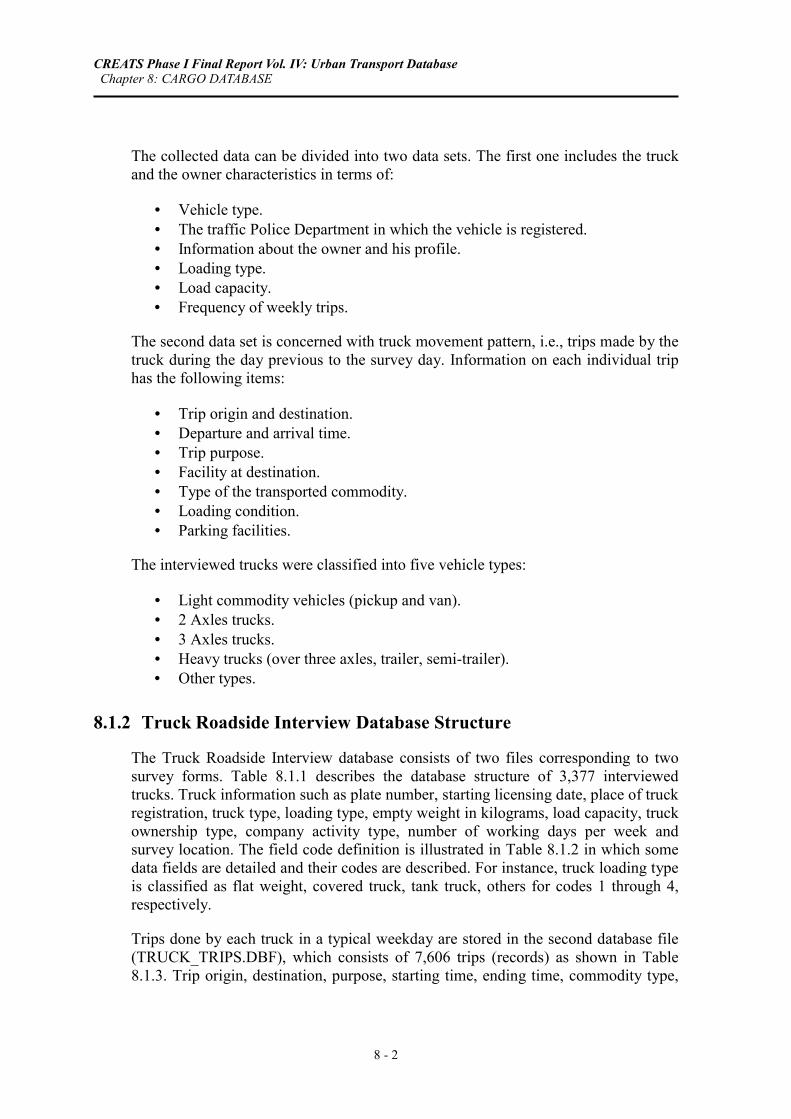
The collected data can be divided into two data sets. The first one includes the truck and the owner characteristics in terms of:
• Vehicle type. • The traffic Police Department in which the vehicle is registered. • Information about the owner and his profile. • Loading type. • Load capacity. • Frequency of weekly trips.
The second data set is concerned with truck movement pattern, i.e., trips made by the truck during the day previous to the survey day. Information on each individual trip has the following items:
• Trip origin and destination. • Departure and arrival time. • Trip purpose. • Facility at destination. • Type of the transported commodity. • Loading condition. • Parking facilities.
The interviewed trucks were classified into five vehicle types:
• Light commodity vehicles (pickup and van). • 2 Axles trucks. • 3 Axles trucks. • Heavy trucks (over three axles, trailer, semi-trailer). • Other types.
8.1.2 Truck Roadside Interview Database Structure
The Truck Roadside Interview database consists of two files corresponding to two survey forms. Table 8.1.1 describes the database structure of 3,377 interviewed trucks. Truck information such as plate number, starting licensing date, place of truck registration, truck type, loading type, empty weight in kilograms, load capacity, truck ownership type, company activity type, number of working days per week and survey location. The field code definition is illustrated in Table 8.1.2 in which some data fields are detailed and their codes are described. For instance, truck loading type is classified as flat weight, covered truck, tank truck, others for codes 1 through 4, respectively.
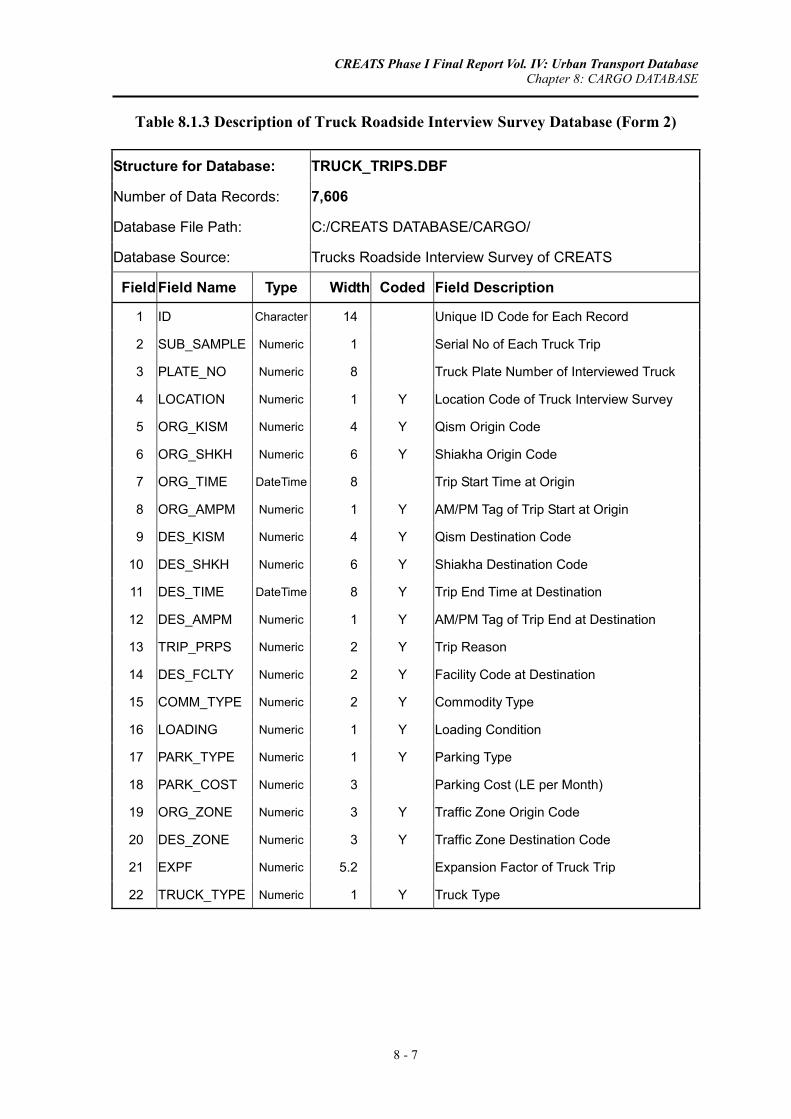
Trips done by each truck in a typical weekday are stored in the second database file (TRUCK_TRIPS.DBF), which consists of 7,606 trips (records) as shown in Table 8.1.3. Trip origin, destination, purpose, starting time, ending time, commodity type,

CREATS Phase I Final Report Vol. IV: Urban Transport Database Chapter 8: CARGO DATABASE
8 - 3
loading condition, parking type, parking cost and truck type are among the data fields of this database. The filed codes are further explained in Table 8.1.4.
8.2 CARGO COMPANIES SURVEY DATABASE
8.2.1 Overview
The Company Survey aimed at identifying the characteristics of cargo companies and cargo movements to and from the company site. The collected data includes the following items:
• Company characteristics
a. Company name and address; b. Company type; c. Company profile; d. Number and types of vehicles owned by the company; e. Number of employees in the company; f. Availability of parking place; and, g. Problems associated with commodity movements.
• Cargo handling information
a. Commodity type; b. The annual transported volume of each commodity; c. Origin and destination of cargo movements; and, d. The main mode of transport.
Fifty companies were selected within the study area for surveying. These companies represent all sectors of the economy. The final sample covers mainly six different economic sectors, which are:
• Transport, logistics services and packing companies (including small size organizations).
• Food and agriculture production.
• Heavy industry (including chemical and petroleum sector).
• Automotive Industry.
• Construction and construction materials.
• Retail and final distribution sector (including supermarket).
Since the required data for the Company Survey consists of general and annual information, the survey could be carried out during any day of the week.

CREATS Phase I Final Report Vol. IV: Urban Transport Database Chapter 8: CARGO DATABASE
8 - 4
8.2.2 Cargo Companies Survey Database Structure
The database structure of cargo companies are presented in Tables 8.2.1 through 8.2.4. The first two tables show the profile of sampled companies. Data such as company type, company profile, number of owned trucks, number of employees, availability of parking lot within company property are included in Table 8.2.1 followed by field code description in Table 8.2.2. The activity of each sampled cargo company is presented in Tables 8.2.3 and 8.2.4. Transported commodity is classified into 9 types as shown in Table 8.2.4

CREATS Phase I Final Report Vol. IV: Urban Transport Database Chapter 8: CARGO DATABASE
8 - 5
Table 8.1.1 Description of Truck Roadside Interview Survey Database (Form 1)
Structure for Database: TRUCK_RSI.DBF
Number of Data Records: 3,377
Database File Path: C:/CREATS DATABASE/CARGO/
Database Source: Trucks Roadside Interview Survey of CREATS
Field Field Name Type Width Coded Field Description
1 ID Character 14 Unique ID Code for Each Interviewed Truck
2 PLATE_NO Numeric 8 Truck Plate Number of Interviewed Truck
3 GVRN_CODE Numeric 2 Y Governorate Code in which the Truck is Registered
4 LICN_DATE Date 8 Starting Licensing Date
5 LICN_KISM Numeric 4 Y Qism Code in which the Truck is Registered
6 LICN_SHKH Numeric 2 Y Shiakha Code in which the Truck is Registered
7 TRUCK_TYPE Numeric 1 Y Truck Type
8 LOAD_TYPE Numeric 1 Y Truck Loading Type
9 EMPTY_WT Numeric 5 Empty Weight of Truck in Kilograms
10 FULL_CAP Numeric 5 Load Capacity of Truck in Kilograms
11 PHONE_NO Character 9 Telephone No. of Truck Owner
12 ADRS_KISM Numeric 4 Y Qism Code of Truck Owner Residence
13 ADRS_SHKH Numeric 2 Y Shiakha Code of Truck Owner Residence
14 TRCK_OWN Numeric 1 Y Truck Ownership Type
15 CMPNY_TYPE Numeric 1 Y Company Activity Type
16 TRCK_DAYS Numeric 1 Y No. of Working Days per Week for Interviewed Truck
17 LOCATION Numeric 1 Location Code of Truck Interview Survey

CREATS Phase I Final Report Vol. IV: Urban Transport Database Chapter 8: CARGO DATABASE
8 - 6
Table 8.1.2 Field Code Definition of Cargo Roadside Interview Survey Database (Form 1)
Field Codes Used in Database: TRUCK_RSI.DBF
Field Field Name Field Description Code Field Code Description
3 GVRN_CODE Governorate Code in which the Truck is Registered See Equivalence Table …..
5 LICN_KISM Qism Code in which the Truck is Registered See Equivalence Table …..
6 LICN_SHKH Shiakha Code in which the Truck is Registered See Equivalence Table …..
7 TRUCK_TYPE Truck Type 1 Light Commodity Truck 2 Two-Axle Truck 3 Three-Axle Truck 4 More than 3 Axles including Trailers 5 Others
8 LOAD_TYPE Truck Loading Type 1 Flat Weight 2 Covered Truck 3 Tank Truck 4 Others
12 ADRS_KISM Qism Code of Truck Owner Residence See Equivalence Table …..
13 ADRS_SHKH Shiakha Code of Truck Owner Residence See Equivalence Table …..
14 TRCK_OWN Truck Ownership Type 1 Individual 2 Company 3 Government
15 CMPNY_TYPE Company Activity Type 1 Transport 2 Construction
3 Manufacturing 4 Wholesale 5 Retail 6 Others
16 TRCK_DAYS No. of Working Days per Week for Interviewed Truck 1 1 - 2 Days per Week
2 3 - 4 Days per Week 3 5 - 6 Days per Week 4 Every Day 5 None
17 LOCATION Location Code of Truck Interview Survey 1 Salah Salem after Sayeda Eisha
2 Autostrad after Maadi Entrance 3 Ring Road before Marg
4 Fiesal St. between Maryoteya St. and Mansoreya St.
5 Bahr El- Azam before Moneeb Bridge
6 Port Said St. bet. Bab Shaareya & Azhar St.
7 Ring Road between Suez and Qatameya Roads
8 Ismailya Desert Road before Oboor Wholesale Market
CREATS Phase I Final Report Vol. IV: Urban Transport Database Chapter 8: CARGO DATABASE
8 - 7
Table 8.1.3 Description of Truck Roadside Interview Survey Database (Form 2)
Structure for Database: TRUCK_TRIPS.DBF
Number of Data Records: 7,606
Database File Path: C:/CREATS DATABASE/CARGO/
Database Source: Trucks Roadside Interview Survey of CREATS
Field Field Name Type Width Coded Field Description
1 ID Character 14 Unique ID Code for Each Record
2 SUB_SAMPLE Numeric 1 Serial No of Each Truck Trip
3 PLATE_NO Numeric 8 Truck Plate Number of Interviewed Truck
4 LOCATION Numeric 1 Y Location Code of Truck Interview Survey
5 ORG_KISM Numeric 4 Y Qism Origin Code
6 ORG_SHKH Numeric 6 Y Shiakha Origin Code
7 ORG_TIME DateTime 8 Trip Start Time at Origin
8 ORG_AMPM Numeric 1 Y AM/PM Tag of Trip Start at Origin
9 DES_KISM Numeric 4 Y Qism Destination Code
10 DES_SHKH Numeric 6 Y Shiakha Destination Code
11 DES_TIME DateTime 8 Y Trip End Time at Destination
12 DES_AMPM Numeric 1 Y AM/PM Tag of Trip End at Destination
13 TRIP_PRPS Numeric 2 Y Trip Reason
14 DES_FCLTY Numeric 2 Y Facility Code at Destination
15 COMM_TYPE Numeric 2 Y Commodity Type
16 LOADING Numeric 1 Y Loading Condition
17 PARK_TYPE Numeric 1 Y Parking Type
18 PARK_COST Numeric 3 Parking Cost (LE per Month)
19 ORG_ZONE Numeric 3 Y Traffic Zone Origin Code
20 DES_ZONE Numeric 3 Y Traffic Zone Destination Code
21 EXPF Numeric 5.2 Expansion Factor of Truck Trip
22 TRUCK_TYPE Numeric 1 Y Truck Type

CREATS Phase I Final Report Vol. IV: Urban Transport Database Chapter 8: CARGO DATABASE
8 - 8
Table 8.1.4 Field Code Definition of Cargo Roadside Interview Survey Database (Form 2)
Field Codes Used in Database: TRUCK_TRIPS.DBF
Field Field Name Field Description Code Field Code Description
4 LOCATION Location Code of Truck Interview Survey
1 Salah Salem after Sayeda Eisha
2 Autostrad after Maadi Entrance
3 Ring Road before Marg
4 Fiesal St. between Maryoteya St. and Mansoreya St.
5 Bahr El Azam before Moneeb Bridge
6 Port Said St. bet. Bab Shaareya & Azhar St.
7 Ring Road between Suez and Qatameya Roads
8 Ismailya Desert Road before Oboor Wholesale Market
5 ORG_KISM Qism Origin Code See Equivalence Table …..
6 ORG_SHKH Shiakha Origin Code See Equivalence Table …..
8 ORG_AMPM AM/PM Tag of Trip Start at Origin
1 A.M. Period
2 P.M. Period
9 DES_KISM Qism Destination Code See Equivalence Table …..
10 DES_SHKH Shiakha Destination Code
See Equivalence Table …..
12 DES_AMPM AM/PM Tag of Trip End at Destination
1 A.M. Period
2 P.M. Period
13 TRIP_PRPS Trip Reason 1 To Work Place 2 To Home 3 Selling or Delivering 4 Buying or Removal 5 Repair Work 6 Return to Working Place 7 Other Business 8 Private Business 9 Others
14 DES_FCLTY Facility Code at Destination
1 Factory
2 Retail Shop / Wholesale Market 3 Warehouse 4 Restaurant / Hotel 5 Construction Site 6 Transportation Site 7 Agricultural Field 8 Office 9 Residence
10 Others

CREATS Phase I Final Report Vol. IV: Urban Transport Database Chapter 8: CARGO DATABASE
8 - 9
Table 8.1.4 Field Code Definition of Cargo Roadside Interview Survey Database (Form 2), Continued
Field Codes Used in Database: TRUCK_TRIPS.DBF
Field Field Name Field Description Code Field Code Description
15 COMM_TYPE Commodity Type 1 Agricultural and Live Stock
2 Food Stuff and Animal Food
3 Solid Fuels
4 Petrol and Petrol Distilled Products
5 Metal Residues and Mining Products
6 Metallurgical Products
7 Raw Materials and Derivations
8 Fertilizers
9 Chemical Products
10 Machines and Vehicles
11 Other Cargo
16 LOADING Loading Condition 1 Empty
2 Less Than 25% Loaded
3 25% Loaded
4 50% Loaded
5 75% Loaded
6 Full Loaded
7 Over Loaded
17 PARK_TYPE Parking Type 1 On Street: Free
2 On Street: Paid
3 Off Street: Paid Private
4 Off Street: Free Private
5 Off Street: Paid Public
6 Off Street: Free Public
7 Others
19 ORG_ZONE Traffic Zone Origin Code
See Equivalence Table …..
20 DES_ZONE Traffic Zone Destination Code
See Equivalence Table …..
22 TRUCK_TYPE Truck Type 1 Light Commodity Truck
2 Two-Axle Truck
3 Three-Axle Truck
4 More than 3 Axles including Trailers
5 Others

CREATS Phase I Final Report Vol. IV: Urban Transport Database Chapter 8: CARGO DATABASE
8 - 10
Table 8.2.1 Description of Cargo Company Profile Survey Database
Structure for Database: COMPANY_PROFILE.DBF
Number of Data Records: 50
Database File Path: C:/CREATS DATABASE/CARGO/
Database Source: Company Interview Survey of CREATS
Field Field Name Type Width Coded Field Description
1 SRVY_DATE Date 8 Survey Date
2 KISM_CODE Numeric 4 Y Qism Code of Company Address
3 SHKH_CODE Numeric 2 Y Shiakha Code of Company Address
4 CMPNY_CODE Numeric 2 Company Unique Code
5 CMPNY_TYPE Numeric 1 Y Company Type
6 CMPNY_PRFL Numeric 1 Y Company Profile (Affiliation)
7 VEH_OWN Numeric 3 Total No of Owned Pickups and Vans
8 AXLE_2 Numeric 3 No of Owned Trucks with Two Axles
9 AXLE_3 Numeric 3 No of Owned Trucks with Three Axles
10 AXLE_MORE Numeric 4 No of Owned Trucks with More Than Three Axles
11 VEH_OTHR Numeric 3 No of Other Owned Trucks
12 DRIVER_NO Numeric 4 No of Drivers Employed by Company
13 EMPLOY_NO Numeric 4 No of Other Employees (Non Drivers)
14 PARK_LOT Numeric 1 Y Availability of Parking Lot Within Company Property
15 PARK_AREA Numeric 6 Area of Parking Lot Owned by Company (m2)
16 PARK_VEH Numeric 4 No of Parked Vehicles in Company Parking Lot
17 PRK_ON_F Numeric 1 Y Code of On-Street Free Parking
18 PRK_ON_P Numeric 1 Y Code of On-Street Paid Parking
19 PRK_OF_F Numeric 1 Y Code of Off-Street Free Parking
20 PRK_OF_P Numeric 1 Y Code of Off-Street Paid Parking
21 PRK_OTHR Numeric 1 Y Code of Other Parking
22 PROBREMS Character 100 Description of Transport Problems (Arabic)
23 CMPNY_NAME Character 31 Company Name (Arabic)
24 KEY_PRSN Character 29 Name of Contact Person (Arabic)
25 ADDRESS Character 38 Company Address (Arabic)
26 TELPHONE1 Character 9 Company Telephone No 1
27 TELPHONE2 Character 9 Company Telephone No 2

CREATS Phase I Final Report Vol. IV: Urban Transport Database Chapter 8: CARGO DATABASE
8 - 11
Table 8.2.2 Field Code Definition of Cargo Company Profile Survey Database
Field Codes Used in Database: COMPANY_PROFILE.DBF
Field Field Name Field Description Code Field Code Description
2 KISM_CODE Qism Code of Company Address See Equivalence Table …..
3 SHKH_CODE Shiakha Code of Company Address See Equivalence Table …..
5 CMPNY_TYPE Company Type 1 Transportation 2 Construction 3 Manufacturing 4 Wholesale 5 Retail 6 Marketing 7 Others
6 CMPNY_PRFL Company Profile (Affiliation) 1 Individual 2 Corporate (Private) 3 Corporate (Public) 4 Government 5 Others
14 PARK_LOT 1 Company Has Its Own Parking Lot
Availability of Parking Lot Within Company Property 2 No Parking Lot

CREATS Phase I Final Report Vol. IV: Urban Transport Database Chapter 8: CARGO DATABASE
8 - 12
Table 8.2.3 Description of Cargo Company Activity Survey Database
Structure for Database: COMPANY_CARGO.DBF
Number of Data Records: 1,952
Database File Path: C:/CREATS DATABASE/CARGO/
Database Source: Company Interview Survey of CREATS
Field Field Name Type Width Coded Field Description 1 CMPNY_CODE Numeric 2 Company Unique Code 2 COMM_NO Numeric 3 Serial No of Commodity Handling Information 3 COMM_TYPE Numeric 2 Y Type of Transported Commodity 4 COMM_VOL Numeric 8 Annual Tonnage of Transported Commodity 5 COMM_MODE Numeric 1 Y Mode Used to Transport Commodity
6 MODE_SHARE Numeric 3 Mode Share Percentage of Transporting Commodity
7 ORG_SHKH Numeric 6 Y Shiakha Origin Code 8 DES_SHKH Numeric 6 Y Shiakha Destination Code
Table 8.2.4 Field Code Definition of Cargo Company Activity Survey Database
Field Codes Used in Database: COMPANY_CARGO.DBF
Field Field Name Field Description CodeField Code Description
3 COMM_TYPE Type of Transported Commodity 1 Agricultural and Live Stock
2 Food Stuff and Animal Food 3 Solid Fuels 4 Petrol and Petrol Distilled Products
5 Metal Residues and Mining Products 6 Metallurgical Products 7 Raw Materials and Derivations 8 Fertilizers 9 Chemical Products 10 Machines and Vehicles 11 Other Cargo
5 COMM_MODE Mode Used to Transport Cargo 1 Truck
2 Railway 3 Inland Waterway Transport
4 Maritime Transport 5 Air Transport 7 ORG_SHKH Shiakha Origin Code See Equivalence Table ….. 8 DES_SHKH Shiakha Destination Code See Equivalence Table …..

CREATS Phase I Final Report Vol. IV: Urban Transport Database Chapter 9:TRAVEL SPEED DATABASE
9 - 1
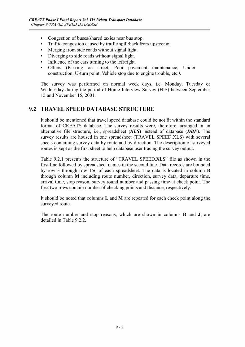
CHAPTER 9: TRAVEL SPEED DATABASE
9.1 OVERVIEW
Travel speed is one of the fundamental characteristics of the traffic flow on the different road sections of the network. Travel speed deterioration, caused by many reasons, results in traffic delay and may add to road accident assurance. Therefore, any comprehensive traffic study should pay great attention to evaluation of the travel speed conditions on the major traffic arterials within the study area. This can be achieved by performing travel speed survey on a great number of major road sections to obtain the existing travel speeds, to identify the existing bottlenecks and their reasoning.
Ten (10) major corridors plus 10 additional roads were selected to carry out travel speed survey. The survey road sections were finalized based on preliminary field survey. The check points were generally set at the center of the major intersections. The selected 20 routes are described later within file structure of travel speed database.
The test car traveled based on car flow by a floating-car technique. The surveyors recorded the time of passing major points, the stopping time as well as the reasons of congestion (9 items). Regarding the survey hours, each route of 10 major corridors was traveled at least fourteen (14) runs in each direction, four runs during morning peak, four runs during evening peak and six runs during off-peak periods. The other ten additional roads were traveled one round trip by each peak periods.
The survey items are as follows:
• Departure time and arrival time, • Passing time by each check point, • Frequency of stops on each road section between successive check points, • Duration of each stop, and • Reason for each stop.
The reasons for stop are shown as below:
• Waiting for traffic light to change. • Traffic accident. • Crossing of pedestrians.
CREATS Phase I Final Report Vol. IV: Urban Transport Database Chapter 9:TRAVEL SPEED DATABASE
9 - 2
• Congestion of buses/shared taxies near bus stop. • Traffic congestion caused by traffic spill-back from upstream. • Merging from side roads without signal light. • Diverging to side roads without signal light. • Influence of the cars turning to the left/right. • Others (Parking on street, Poor pavement maintenance, Under
construction, U-turn point, Vehicle stop due to engine trouble, etc.).
The survey was performed on normal week days, i.e. Monday, Tuesday or Wednesday during the period of Home Interview Survey (HIS) between September 15 and November 15, 2001.
9.2 TRAVEL SPEED DATABASE STRUCTURE
It should be mentioned that travel speed database could be not fit within the standard format of CREATS database. The survey results were, therefore, arranged in an alternative file structure, i.e., spreadsheet (XLS) instead of database (DBF). The survey results are housed in one spreadsheet (TRAVEL SPEED.XLS) with several sheets containing survey data by route and by direction. The description of surveyed routes is kept as the first sheet to help database user tracing the survey output.
Table 9.2.1 presents the structure of “TRAVEL SPEED.XLS” file as shown in the first line followed by spreadsheet names in the second line. Data records are bounded by row 3 through row 156 of each spreadsheet. The data is located in column B through column M including route number, direction, survey data, departure time, arrival time, stop reason, survey round number and passing time at check point. The first two rows contain number of checking points and distance, respectively.
It should be noted that columns L and M are repeated for each check point along the surveyed route.
The route number and stop reasons, which are shown in columns B and J, are detailed in Table 9.2.2.

CREATS Phase I Final Report Vol. IV: Urban Transport Database Chapter 9:TRAVEL SPEED DATABASE
9 - 3
Table 9.2.1 Description of Travel Speed Survey Database
Structure for Database: TRAVEL SPEED.XLS
Spreadsheet Name: 1D1, 1D2, 2D1, 2D2, 3D1, 3D2, …, 20D1, 20D2
Number of Data Records: Row 3 : Row 156
Database File Path: C:¥CREATS DATABASE¥TRAVEL SPEED¥
Database Source: Travel Speed Survey of CREATS
Column Type Coded Column Label B Numeric Y Route No C Numeric Direction No D Numeric Survey Month E Numeric Survey Day F Numeric Departure Time (Hour) G Numeric Departure Time (Minute) H Numeric Arrival Time (Hour) I Numeric Arrival Time (Minute) J Numeric Y Stop Reason K Numeric Survey Round No L Numeric Passing Time at Check Point (Minute) M Numeric Passing Time at Check Point (Second)
Row 1 Numeric No of Check Point Row 2 Numeric Distance (Km)
Note: Columns L and M are repeated for every check point along the surveyed route
Table 9.2.2 Field Code Definition of Travel Speed Survey Database
Column Codes Used in Spreadsheet: TRAVEL SPEED.XLS
Column Column Label Description Code Column Code Description
B Route No Route Name R01Cornish Road (Helwan) - Teret Ismailya St. - Kablat St. - Abu Bakr Sedeeq - Hussein Kamel Seleem St.
R02Gamal Abdel Naser (Abu El Nomros - Giza - Waraq) up to CRR
R036th of October Flyover (Agooza - Ghamara - Nasr Road)
R04Tahreer St. (Dokki) - Geish St. - Abaseya St. - Khaleefa El Maamoon St. - Fareeq Azeez El Masry St. (Up to CRR)

CREATS Phase I Final Report Vol. IV: Urban Transport Database Chapter 9:TRAVEL SPEED DATABASE
9 - 4
Table 9.2.2 Field Code Definition of Travel Speed Survey Database (Continued)
Column Codes Used in Spreadsheet: TRAVEL SPEED.XLS
Column Column Label Description Code Column Code Description
B R11Abdel Moniem Reyad Sq. - Ramsees Sq. - Salah Salem Rd. - Nasr Rd.
R12Nasr Rd. - Estad - Maqreezi - Qoba Sq. - Wayly El Ahd - Port Said
R13Nasr Rd.- Salah El Deen - Mogharbelin Rd. - Azhar Sq. - Ataba Sq. - Soliman Rd. - Ramsees Sq.
R14
Ramsees Sq. - Alfy Rd. - Abdel Khaleq Sarwat Rd. - Sami El Barody Rd. - Mohamed Fareed Rd. - Shereef Rd. - Talaat Sq. - Champollion Rd. - Abdel Moniem Reyad Sq.
R15Sad Rd. - Beiram El Tonsy Rd. - Mohamed Izz Rd. - Ismail Abaza Rd. - Magles al Shaab Rd. - Sheikh Rd. - Tahreer Sq.
R16Sheikh Rehan Rd. - Qasr El Aini Rd. - Falaky Rd. - Mohamed Fareed Rd. - Port Said
R17Magles al Shaab Rd.- Port Said Rd. - Mohamed Fareed Rd. - Falaky Rd. - Qasr El Aini Rd.
R18Ketkat Sq. - Ahmed Orabi Rd. - Gamiet El Dowal Arabia Rd. - Tahreer Rd. - Sarwat Rd. - Giza Flyover
R19Sudan Rd. - Sphinx Sq. - Batal Ahmed Abdel Aziz Rd. - Nasr Sq. - Sudan Rd.
R20Gamiet El Dowal Arabia Rd. - 6th October Br. - Tahreer Rd. - Sarwat Rd.
J Stop Reason 1 Waiting for traffic light to change
2 Traffic accident
3 Crossing of pedestrians
4 Congestion of buses near bus stop
5 Traffic congestion (traffic spilled back condition)
6 Merging from alley
7 Diverging to alley
8 Influence of the cars turning to the left/right
9 Others

CREATS Phase I Final Report Vol. IV: Urban Transport Database Chapter 10:ROAD CONDITION DATABASE
10 - 1
CHAPTER 10: ROAD INVENTORY DATABASE
10.1 OVERVIEW
The transport model requires detailed level of network information, the major part of which is related to the road network. The road network, either existing or proposed, is divided into links (road segments) separated by nodes (junctions/intersections), with each link described by a unique set of operating conditions, such as speed, capacity, chainage and physical content. The designation of capacity of a road segment necessitates an input of such characteristics as number of lanes, divided or undivided, road side activity and parking conditions to identify the level of side friction, grades, and intersection conditions.
One objective of the road condition survey is to identify the characteristics of road network to contribute to the network building of the transport model, so that the model should be able to reflect the real road network conditions as much as possible. The other objective is to obtain road surface conditions of major corridors to estimate the average road surface conditions in the Study Area based on these results, which can contribute to the preliminary analysis of road surface conditions in the Study Area.
Based on the road inventory survey, the general physical road inventory elements, such as length, number of lanes, carriageway width, sidewalks, level of roadside frictions, road side parking conditions, number of signalized and unsignalized intersections could be obtained. Since these general physical inventory data are expected to be obtained for major road links to be built in the computerized model, such data are expected to be obtained for all the major inter-Shiakha roads. In total the road inventory survey was carried out for some 65 corridors including the 20 major corridors (public transport routes), for which the travel speed survey was implemented.
The road surface conditions for 20 major public transport routes in the Greater Cairo Metropolitan Area (GCMA) was observed expressed by the Pavement Condition Index (PCI).

CREATS Phase I Final Report Vol. IV: Urban Transport Database Chapter 10:ROAD CONDITION DATABASE
10 - 2
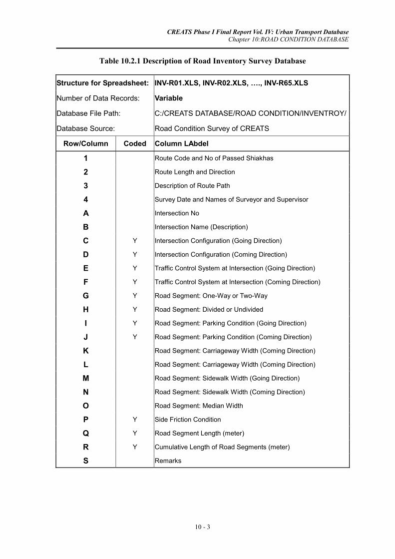
10.2 ROAD CONDITION DATABASE STRUCTURE
The road condition database was built using both file structures, i.e. spreadsheet style (XLS) for road inventory data and database style (DBF) for PCI data. Table 10.2.1 shows the database file structure of road inventory data, which are organized in 65 spreadsheet files, each one corresponding to one route. The route code and number of passed Shiakhas are shown in the first row. The route length and direction are illustrated in the second row, while route description is indicated in the third row.
The general physical road inventory will include the following data for each road section.
• One way or two way. • Side friction level caused by roadside activities (level 1: high, level 2: medium,
level 3: low). • Roadside parking (yes/no, one side or two sides). • Pavement width (m). • Number of intersection and their configuration (three-leg, four-leg or more,
roundAbut) and traffic control (signalized/unsignalized). • Median (yes/no).
In Table 10.2.1, intersection characteristics are indicated in columns A through F, while road segments characteristics are shown in columns G through R. The description of coded fields are given in Table 10.2.2. For example, the intersection configuration (see column D) may be 3-leg, 4-leg, roundAbut or other depending on its field code value.
Pavement Condition Index (PCI) method was used to depict the pavement condition at the selected road sections. The results, including the deduct points of each distress and the overall PCI value for each section, are then estimated.
The second part of road condition survey was investigating the road surface condition using PCI value for the 20 major public transport routes. PCI database adopts the standard file format as shown in Tables 10.2.3 and 10.2.4. It should be noted that Table 10.2.3 contains many data fields that were used to estimate the Pavement Condition Index (PCI) shown in field number 66. Route description and direction are detailed in Table 10.2.4.
CREATS Phase I Final Report Vol. IV: Urban Transport Database Chapter 10:ROAD CONDITION DATABASE
10 - 3
Table 10.2.1 Description of Road Inventory Survey Database
Structure for Spreadsheet: INV-R01.XLS, INV-R02.XLS, …., INV-R65.XLS
Number of Data Records: Variable
Database File Path: C:/CREATS DATABASE/ROAD CONDITION/INVENTROY/
Database Source: Road Condition Survey of CREATS
Row/Column Coded Column LAbdel
1 Route Code and No of Passed Shiakhas
2 Route Length and Direction
3 Description of Route Path
4 Survey Date and Names of Surveyor and Supervisor
A Intersection No
B Intersection Name (Description)
C Y Intersection Configuration (Going Direction)
D Y Intersection Configuration (Coming Direction)
E Y Traffic Control System at Intersection (Going Direction)
F Y Traffic Control System at Intersection (Coming Direction)
G Y Road Segment: One-Way or Two-Way
H Y Road Segment: Divided or Undivided
I Y Road Segment: Parking Condition (Going Direction)
J Y Road Segment: Parking Condition (Coming Direction)
K Road Segment: Carriageway Width (Coming Direction)
L Road Segment: Carriageway Width (Coming Direction)
M Road Segment: Sidewalk Width (Going Direction)
N Road Segment: Sidewalk Width (Coming Direction)
O Road Segment: Median Width
P Y Side Friction Condition
Q Y Road Segment Length (meter)
R Y Cumulative Length of Road Segments (meter)
S Remarks

CREATS Phase I Final Report Vol. IV: Urban Transport Database Chapter 10:ROAD CONDITION DATABASE
10 - 4
Table 10.2.2 Field Code Definition of Road Inventory Survey Database
Column Codes Used in Spreadsheet: INV-R01.XLS, INV-R02.XLS, ….
Column Column LAbdel Code Column Code Description
C Intersection Configuration (Going Direction) 1 Three-Leg Intersection
D Intersection Configuration (Coming Direction) 2 Four-Leg Intersection
3 RoundAbut
4 Other
E Traffic Control System at Intersection (Going Direction) 1 Signalized
F Traffic Control System at Intersection (Coming Direction) 2 Un-signalized
G Road Segment: One-Way or Two-Way 1 One-Way
2 Two-Way
H Road Segment: Divided or Undivided (Going Direction) 1 Divided
2 Undivided
I Road Segment: Parking Condition (Going Direction) 1 One Side
J Road Segment: Parking Condition (Coming Direction) 2 Two Sides
3 No Parking
P Side Friction Condition 1 Low
Q Road Segment Length (meter) 2 Medium
R Cumulative Length of Road Segments (meter) 3 High

CREATS Phase I Final Report Vol. IV: Urban Transport Database Chapter 10:ROAD CONDITION DATABASE
10 - 5
Table 10.2.3 Description of Road Pavement Index (PCI) Database
Structure for Database: ROAD_PCI.DBF
Number of Data Records: 669
Database File Path: C:/CREATS DATABASE/ROAD CONDITION/PCI/
Database Source: Road Condition Survey of CREATS
Field Field Name Type Width Coded Field Description
1 ROAD_CODE Character 4 Y Road Code 2 DIRECTION Numeric 2 Y Direction of Survey 3 SECTION Numeric 3 Surveyed Road Section No 4 WIDTH_M Numeric 6 Carriageway Width (Meters) 5 FROM_KM Numeric 3 Start Kilometrage for Surveyed Road Section 6 TO_KM Numeric 5 End Kilometrage for Surveyed Road Section 7 DV_L01 Character 3 Alligator Cracking: Low Severity 8 DV_M01 Character 3 Alligator Cracking: Medium Severity 9 DV_H01 Character 3 Alligator Cracking: High Severity
10 DV_L02 Character 1 Bleeding: Low Severity 11 DV_M02 Character 2 Bleeding: Medium Severity 12 DV_H02 Character 2 Bleeding: High Severity 13 DV_L03 Character 2 Block Cracking: Low Severity 14 DV_M03 Character 1 Block Cracking: Medium Severity 15 DV_H03 Character 3 Block Cracking: High Severity 16 DV_L04 Character 2 Bumps and Sags: Low Severity* 17 DV_M04 Numeric 3 Bumps and Sags: Medium Severity* 18 DV_H04 Character 3 Bumps and Sags: High Severity* 19 DV_L05 Character 2 Corrugation: Low Severity 20 DV_M05 Numeric 3 Corrugation: Medium Severity 21 DV_H05 Character 3 Corrugation: High Severity 22 DV_L06 Character 2 Depression: Low Severity 23 DV_M06 Numeric 2 Depression: Medium Severity 24 DV_H06 Character 3 Depression: High Severity 25 DV_L07 Character 2 Edge Cracking: Low Severity* 26 DV_M07 Character 2 Edge Cracking: Medium Severity* 27 DV_H07 Character 2 Edge Cracking: High Severity* 28 DV_L08 Character 9 Joint Reflection Cracking: Low Severity* 29 DV_M08 Character 9 Joint Reflection Cracking: Medium Severity* 30 DV_H08 Character 9 Joint Reflection Cracking: High Severity* 31 DV_L09 Character 9 Lane/Shoulder Drop Off: Low Severity* 32 DV_M09 Character 2 Lane/Shoulder Drop Off: Medium Severity* 33 DV_H09 Character 2 Lane/Shoulder Drop Off: High Severity* 34 DV_L10 Character 2 Long &Trans Cracking: Low Severity* 35 DV_M10 Character 2 Long &Trans Cracking: Medium Severity*

CREATS Phase I Final Report Vol. IV: Urban Transport Database Chapter 10:ROAD CONDITION DATABASE
10 - 6
Table 10.2.3 Description of Road Pavement Index (PCI) Database, Continued
Structure for Database: ROAD_PCI.DBF
Number of Data Records: 669
Database File Path: C:/CREATS DATABASE/ROAD CONDITION/PCI/
Database Source: Road Condition Survey of CREATS
Field Field Name Type Width Coded Field Description 36 DV_H10 Character 3 Long &Trans Cracking: High Severity* 37 DV_L11 Character 3 Patching & Utility Cut Patching: Low Severity 38 DV_M11 Numeric 3 Patching & Utility Cut Patching: Medium Severity 39 DV_H11 Numeric 3 Patching & Utility Cut Patching: High Severity 40 DV_L12 Character 3 Polished Aggregate: Low Severity 41 DV_M12 Character 9 Polished Aggregate: Medium Severity 42 DV_H12 Character 2 Polished Aggregate: High Severity 43 DV_L13 Character 9 Potholes: Low Severity 44 DV_M13 Character 3 Potholes: Medium Severity 45 DV_H13 Character 3 Potholes: High Severity 46 DV_L14 Character 9 Railroad Crossing: Low Severity 47 DV_M14 Character 2 Railroad Crossing: Medium Severity 48 DV_H14 Character 3 Railroad Crossing: High Severity 49 DV_L15 Character 9 Rutting: Low Severity 50 DV_M15 Character 2 Rutting: Medium Severity 51 DV_H15 Character 3 Rutting: High Severity 52 DV_L16 Character 2 Shoving: Low Severity 53 DV_M16 Character 2 Shoving: Medium Severity 54 DV_H16 Character 3 Shoving: High Severity 55 DV_L17 Character 2 Slippage Cracking: Low Severity 56 DV_M17 Character 2 Slippage Cracking: Medium Severity 57 DV_H17 Character 2 Slippage Cracking: High Severity 58 DV_L18 Character 9 Swell: Low Severity 59 DV_M18 Character 9 Swell: Medium Severity 60 DV_H18 Character 2 Swell: High Severity 61 DV_L19 Character 2 Weathering and Raveling: Low Severity 62 DV_M19 Character 3 Weathering and Raveling: Medium Severity 63 DV_H19 Character 3 Weathering and Raveling: High Severity 64 TOTAL_DV Numeric 4 Total Distress Deduct Value 65 CDV Numeric 3 Corrected Distress Deduct Value 66 PCI Numeric 4 Pavement Condition Index
* All distresses are measured in squared meters except for distresses numbers 4, 7, 8, 9 and 10, which are measured.

CREATS Phase I Final Report Vol. IV: Urban Transport Database Chapter 10:ROAD CONDITION DATABASE
10 - 7
Table 10.2.4 Field Code Definition of Road Pavement Index (PCI) Database
Field Codes Used in Database: ROAD_PCI.DBF
Field Name and Description
ROAD_CODE DISCRIPTION Description of DIRECTION 1
R01 Cornish Road (Helwan) - Teret Ismailya St. - Kablat St. - Abu Bakr Sedeeq - Hussein Kamel Seleem St.
Waraq to Abu El Nomros
R02 Gamal Abdel Naser (Abu El Nomros - Giza - Waraq) up to CRR
Nasr Road to Agooza
R03 6th of October Flyover (Agooza - Ghamara - Nasr Road)
Dokki Sq. to Ring Road
R04 Tahreer St. (Dokki) - Geish St. - Abaseya St. - Khaleefa El Maamoon St. - Fareeq Azeez El Masry St. (Up to CRR)
Madkhal El Mansoreya to Matar Bus Station
R05 Pyramid area - El Haram St. - Rooda - Salah Salem St. - Orooba St. (Airpot).
Teraat El Ismaileya With Ring Road to Saft El Laban With Ring Road
R06 Saft El Laban - Sarwat St. - Abdel Salam Aaref St. - Gamaa Bridge - Port Said St. - Teret El Howary St. - Horya St. - Petrol Companies Road - Teret Ismailya Road up to CRR
Helwan to Taqatoa El Suez With Ring Road
R07 Nasr Road (Helwan) - Citadel - Nasr City - Suez Road up CRR
Sayeda Zeinab Sq. to Houndai Service Center
R08 Sayeda Zeinab Sq. - Port Said St. - Komy St. - Khayry St. - Magles El Shaab St. - Emad El Deen St. - Ahmed Helmy St. - Alex. Agr. Road (CRR).
Tahreer Sq. to Moasasa Sq.
R09 Tahreer Sq. - Talat Harb St. - Oraby St. - Shobra St. - Madraset El Mamaleek St. - Korneish St. - Magles El Madina St. - Shobra El Kheima Metro Station
Azhar With Salah Salem to 26 July With Ring Road
R10 26th of July St. (CRR) - Zamalek - Abdel Khaleq Sarwat St. - Opera Sq. - Azhar St. - Gohar El Qaed St. (Salah Salem ST.)
Teraat El Zomor With El Moneeb Br.
R11 Zomor Canal Road from El Moneeb Flyover to Galatma Road
Taqatoa El Mansoreya to Giza Sq.
R12 Feisal St. from Giza Sq. to Mansoreya Canal Kit Kat Sq. to Feisal Br.
R13 Sudan St. from under Feisal Flyover to Kit Kat Sq. The End Of Rood El Farag Br. to
Rood El Farag Corridor With Ring Road
R14 (CCR) Rood al-Farag Corridor - Moneera - Waraq - Rood al-Farag Bridge up to Korneish El Nile St.
Korneish With Magles El Madina to Ring Road
R15 Intersection between Korneish St. & Magles El Madina St. - Sharqaweya Bridge - Qanater Agriculture Road up to CRR
Korneish El Maadi to Saqr Qoreish
R16 Nahda St. - 275 St. - Nady El Gedeed St. - Laselky St. - Nasr Road
Hay El Sades With El Shaheed Ahmed Shawqy to Khalafawy Sq.
R17 Hay El sads St. - Ismail El Fangary St. - Seket El Wayly St. - Manshyat El Gamal St. - Maamal El Alban Street (Al Khalafawy Sq.)
Ramsees St.Extension With Nasr Road to The End Of Afreqya St
R18 Imtedad Ramsees Street from Nasr Road - Shaheed Ahmed Shawqy St. - Khaleefa El Qaher St. - Mostafa El Nahas St. - End of Afreqya St.
Alf Maskan Sq. to Emarat El Mohandeseen
R19 End of Ibraheem Abu El Naga St. - Abu El Atahya St. - Abas El Aqad St. - El Nozha St. - Shaheed Fareed Semeka St. (Alf Maskan Sq.)
Suez Road to Matar Br.
R20 From Matar Flyover to Cairo-Suez Desert Road (Matar Ring Road)

CREATS Phase I Final Report Vol. IV: Urban Transport Database Chapter 11: PARKING DATABASE
11 - 1
CHAPTER 11: PARKING DATABASE
Traffic management and control in urban areas is highly affected by discrepancy between parking demand and supply especially in down town areas and in the vicinity of activity centers. The traffic congestions and reduction of traffic capacity on most road sections in the Cairo city are primarily caused by inevitable on-street parking. The successfulness of any traffic planning is conditioned by the extent to which the parking requirements are achieved.
Consequently the study of parking demand and supply should be always a basic integral constituent of any traffic study. Good estimates of quantitative parking supply requirements are conditioned by the good awareness Abuut the characteristics of usage of existing parking facilities, i.e. parking durations and turnovers on street, off-street or in parking garages.
The parking survey is classified into two kinds of survey as off-street parking survey and on-street parking survey. The off-street parking survey includes 5 locations for multi-storey garage survey outlined in Section 11.1 and 10 lots for at-grade parking lot survey addressed in Section 11.2. The on-street survey is composed of parking parameter survey on 30 road sections as parking duration and parking turn-over rate (see Section 11.3) and parking occupancy survey in CBD areas (see Section 11.4).
11.1 MULTI-STOREY GARAGE INTERVIEW DATABASE
11.1.1 Overview
Regarding the multi-storey garages survey, the surveyors were located at entrance and at exit of the garage. The surveyors recorded the plate number of each vehicle, the arrival/exit time and counted the number of vehicles by types. The survey period was 24 hours from 6:00 AM to 6:00 AM in the next morning. The multi-storey garage survey includes garage-user interview survey for 200 samples and the situation of parking facilities in the 5 surveyed garages.

CREATS Phase I Final Report Vol. IV: Urban Transport Database Chapter 11: PARKING DATABASE
11 - 2
The garage-user interview survey includes the following items:
• Person characteristics, e.g., sex and occupation.
• Parking information, e.g., parking purpose, duration, charge, payer of parking charge, frequency of usage, usage of other garages and any problems on parking, origin place distance and walking distance.
The survey items for the parking facilities survey were as follows:
• Building: parking area and number of stories,
• Parking space: parking capacity, average daily number of parking cars and average parking duration,
• Parking charge: parking charge, ticket issue, and charge collection system.
The parking survey was performed on normal week days, i.e. Monday, Tuesday or Wednesday during the period of Home Interview Survey (HIS) between September 15 and November 15, 2001.
11.1.2 GARAGE INTERVIEW Database Structure
The collected data of multi-storey garage interview survey is stored in a standard file format (GARAGE_COUNTS.DBF and GARAGE_INTERVIEWS.DBF) in which around 10,320 and 200 records represent the total number of counted vehicles and the total number of interview records, respectively. Table 11.1.1 shows the database structure of the counted vehicles at different garages. Garage code, direction, survey date, vehicle type, vehicle plate number and number of passengers in the counted vehicle were included in Table 11.1.1. The field code description for garage code, direction and vehicle type are given in Table 11.1.2.
The file structure of the garage-user interview records is given in Table 11.1.3 followed by Table 11.1.4 for field code description.

CREATS Phase I Final Report Vol. IV: Urban Transport Database Chapter 11: PARKING DATABASE
11 - 3
Table 11.1.1 Description of Garage Count Database
Structure for Database: GARAGE_COUNTS.DBF
Number of Data Records: 10,329
Database File Path: C:/CREATS DATABASE/PARKING/GARAGE/
Database Source: Parking Survey of CREATS
Field Field Name Type Width Coded Field Description
1 GRG_CODE Character 3 Y Garage Code
2 IN_OUT Numeric 1 Y Code for Entering or Exiting the Garage
3 SRVY_DAY Numeric 2 Survey Day
4 SRVY_MONTH Numeric 2 Survey Month
5 VEH_SR Numeric 5 Serial No of Vehicle Entering or Exiting the Garage
6 SRVY_HR Numeric 2 Survey Hour
7 SRVY_MIN Numeric 2 Survey Minute
8 PRVT_CAR Numeric 1 Y Code for Private Car
9 MICROBUS Numeric 1 Y Code for Microbus
10 VAN Numeric 1 Y Code for Van
11 OTHERS Numeric 1 Y Code for Other Vehicles
12 PLATE_NO Numeric 8 Plate No of Vehicle
13 OCCUPANCY Numeric 2 No of Passengers in the Counted Vehicle
Table 11.1.2 Field Code Definition of Garage Count Database
Field Codes Used in Database: GARAGE_COUNTS.DBF
Field Field Name Field Description Code Field Code Description
1 GRG_CODE Garage Name G01 Opera Garage G03 Gomhoreya Garage
G04 Ataba Garage
G05 Ramsees Hilton Shopping Center Garage
2 IN_OUT Code for Entering or Exiting the Garage
1 Entering the Garage
2 Exiting the Garage 8 PRVT_CAR Code for Private Car 0 No Count 9 MICROBUS Code for Microbus 1 This Vehicle Type is Counted
10 VAN Code for Van 11 OTHERS Code for Other Vehicles

CREATS Phase I Final Report Vol. IV: Urban Transport Database Chapter 11: PARKING DATABASE
11 - 4
Table 11.1.3 Description of Garage Interview Database
Structure for Database: GARAGE_INTERVIEWS.DBF
Number of Data Records: 200
Database File Path: C:/CREATS DATABASE/PARKING/GARAGE/
Database Source: Parking Survey of CREATS
Field Field Name Type Width Coded Field Description 1 GRG_CODE Character 11 Y Garage Code 2 DAY Numeric 2 Survey Day 3 MONTH Numeric 2 Survey Month 4 YEAR Numeric 4 Survey Year 5 Q1 Numeric 1 Y Gender 6 Q2 Numeric 1 Y Occupation 7 Q3 Numeric 1 Y Purpose of Parking 8 Q4_1 Numeric 1 Y Where Did You Come From: Type of Facility 9 Q4_2 Numeric 1 Y Where Did You Come From: How Far
10 Q5 Numeric 1 Y Parking Duration and Charge 11 Q6 Numeric 1 Y Who Does Pay for Parking Charge this Parking
12 Q7 Numeric 1 Y How Many Times Do You Use This Garage in a Week
13 Q8 Numeric 1 Y Can You Use Other Garage if This Garage Is Not Available
14 Q9 Numeric 1 Y Do You Have Any Problem on Parking
Table 11.1.4 Field Code Definition of Garage Interview Database
Field Codes Used in Database: GARAGE_INTERVIEWS.DBF
Field Field Name Field Description Code Field Code Description 1 GRG_CODE Garage Name G01 Opera Garage
G03 Gomhoreya Garage G04 Ataba Garage G05 Ramsees Hilton Shopping Center Garage5 Q1 Gender 1 Male 2 Female 6 Q2 Occupation 1 Director and Manager 2 Professional Workers 3 Clerical Workers 4 Sales Workers 5 Services Workers 6 Others 7 Q3 Purpose of Parking 1 To working Place 2 To school/Institute 3 To Home 4 Business Activity 5 Shopping, Eating and Private Activities 6 Others

CREATS Phase I Final Report Vol. IV: Urban Transport Database Chapter 11: PARKING DATABASE
11 - 5
Table 11.1.4 Field Code Definition of Garage Interview Database (Continued)
Field Codes Used in Database: GARAGE_INTERVIEWS.DBF
Field Field Name Field Description Code Field Code Description 8 Q4_1 Where Did You Come From:
Type of Facility 1 Residence
2 Private Office 3 Government Office 4 School/Institute 5 Shops/Restaurant 6 Others 9 Q4_2 Where Did You Come From:
How Far 1 In This Building
2 < 500 m Apart 3 50 - 100 m Apart 4 100 - 200 m Apart 5 200 - 300 m Apart 6 300 - 400 m Apart 7 > 500 m Apart
10 Q5 Parking Duration and Charge 1 Less than half hour 2 0.5 - 1.0 hours 3 1.0 - 1.5 hours 4 1.5 - 2.0 hours 5 2.0 - 3.0 hours 6 3.0 - 5.0 hours 7 > 5.0 hours
11 Q6 Who Does Pay for Parking Charge this Parking
1 By myself
2 Company 3 Free
12 Q7 How Many Times Do You Use This Garage in a Week
1 Every day except holiday
2 Less than 1 time 3 1 - 2 times 4 2 - 3 times 5 3 - 4 times 6 4 - 5 times 7 More than 5 times
13 Q8 Can You Use Other Garage if This Garage Is Not Available
1 Yes, easily
2 Another similar garage 3 On road 4 Others 5 Difficult 6 Impossible
14 Q9 Do You Have Any Problem on Parking
1 No problem
2 Problems, Please specify

CREATS Phase I Final Report Vol. IV: Urban Transport Database Chapter 11: PARKING DATABASE
11 - 6
11.2 AT-GRADE PARKING LOT SURVEY DATABASE
11.2.1 Overview
The methodology of performing multi-storey garages survey was applied in at-grade parking lot survey. Ten off-street parking lots were surveyed for 16 hours from 6:00 AM to 10:00 PM.
The survey was performed on normal week days, i.e. Monday, Tuesday or Wednesday during the period of Home Interview Survey (HIS) between September 15 and November 15, 2001.
11.2.2 Off-Street Parking Survey Database Structure
The standard file structure format was applied to the database housing the off-street parking lots survey results. The structure of Table 11.2.1 is similar to Table 11.1.1 except for the first field in both, which represents the name of surveyed off-street parking facility. The names of surveyed off-street parking lots are given in Table 11.2.2.
11.3 ON-STREET PARKING SURVEY DATABASE
11.3.1 Overview
The on-street parking survey is basically different from off-street and garages parking surveys in that the arrival and departure of cars in case of on-street occur randomly anywhere along the road side and not at an entrance or an exit gate.
The Study Team selected 30 road segments to carry out this kind of survey. Within each road side, the parked vehicles were counted at 30-minute intervals during the survey period. The specified road section is walked by the surveyor who notes down the type and the plate number of every parked vehicle. The survey period was 16 hours from 6:00 AM to 10:00 PM.
11.3.2 On-Street Parking Survey Database Structure
The alternative file structure format (XLS) was used to keep the on-street parking survey results as indicated in Table 11.3.1 in which a series of Excel files named “PS-N01.XLS” through “PS-N30.XLS” were built to keep the survey data for location 1 through location 30, respectively.
It should be noted that each of the 30 files has two spreadsheets for direction 1 and direction 2 as illustrated in the second row of Table 11.3.1. Survey location names are shown in Table 11.3.2 together with vehicle type code.

CREATS Phase I Final Report Vol. IV: Urban Transport Database Chapter 11: PARKING DATABASE
11 - 7
Table 11.2.1 Description of Off-Street Survey Database
Structure for Database: OFF-STREET_PARKING.DBF
Number of Data Records: 8,226
Database File Path: C:/CREATS DATABASE/PARKING/OFF-STREET/
Database Source: Parking Survey of CREATS
Field Field Name Type Width Coded Field Description 1 PRK_CODE Character 3 Y Off-Street Parking Lot Code 2 IN_OUT Numeric 1 Y Code for Entering or Exiting the Parking Lot 3 SRVY_DAY Numeric 2 Survey Day 4 SRVY_MONTH Numeric 2 Survey Month
5 VEH_SR Numeric 4 Serial No of Vehicle Entering or Exiting the Parking Lot
6 SRVY_HR Numeric 2 Survey Hour 7 SRVY_MIN Numeric 2 Survey Minute 8 PRVT_CAR Numeric 1 Y Code for Private Car 9 MICROBUS Numeric 1 Y Code for Microbus
10 VAN Numeric 1 Y Code for Van 11 OTHERS Numeric 1 Y Code for Other Vehicles 12 PLATE_NO Numeric 8 Plate No of Vehicle 13 OCCUPANCY Numeric 2 No of Passengers in the Counted Vehicle
Table 11.2.2 Field Code Definition of Off-Street Survey Database
Field Codes Used in Database: OFF-STREET_PARKING.DBF
Field Field Name Field Description Code Field Code Description 1 PRK_CODE Off-Street Parking Lot Code F01 Abdel Moniem Reyad Sq. (East)
F02 Near Omar Makram Mosque F03 Abdel Moniem Reyad Sq. (West) F04 Falaky Paking Lot
F05 Ahmed Oraby St. (in front of Omar Afandy)
F06 Under 26th of July Corridor before Sphinx Sq. (15th of May Lot)
F07 Under 26th of July Corridor at
Korniesh Parking Lot (Egoth company)
F08 Under 26th of July Corridor in front of Zamalek Club
F09 Mesaha Sq. F10 Garden Lot at Tersana Towers Area2 IN_OUT 1 Entering the Garage 2 Exiting the Garage 8 PRVT_CAR Code for Private Car 0 No Count 9 MICROBUS Code for Microbus 1 This Vehicle Type is Counted
10 VAN Code for Van 11 OTHERS Code for Other Vehicles

CREATS Phase I Final Report Vol. IV: Urban Transport Database Chapter 11: PARKING DATABASE
11 - 8
Table 11.3.1 Description of On-Street Survey Database
Structure for Database: PS4-Nxx.XLS*
Spreadsheet Name: Direction1 and Direction2
Number of Data Records: Variable
Database File Path: C:/CREATS DATABASE/PARKINGT/ON-STREET
Database Source: Parking Survey of CREATS
Row/Column Type Coded Column Label
5 Character Street Name
6 Character Y Street Code
7 Numeric Y Direction
7 Character Direction: From
7 Character Direction: To
6 Date Date of Survey
7 Character Name Activity Center (CBD, Roxy - Abas El Aqad or Giza)
A Character Y Vehicle Type
B Character Plate No
Nxx: A Number ranges form 01 to 30, which represents the survey location code
Columns A and B are repeated for every counting period (30-minute).

CREATS Phase I Final Report Vol. IV: Urban Transport Database Chapter 11: PARKING DATABASE
11 - 9
Table 11.3.2 Field Code Definition of On-Street Survey Database
Column Codes Used in Spreadsheet: PS4-Nxx.XLS*
Field Field Description Code Code Description
Nxx Survey Location No N01 Geish St. N02 Abd El Aziz St. N03 Talaat Harb N04 Abd El Salam Aaref St. & Mohamed Fareed St. N05 Tahreer St. N06 Gomhoreya St. N07 Port Said St. N08 Nobar St. N09 Khayrat St. N10 Ali Yosef St. N11 Maahad Eshtraky St. N12 Makram Ebeid St. N13 Hassan Maamoon St. N14 Abas El Aqad St. N15 Tayaran St. N16 Ahram St. N17 Haroon El Rasheed St. N18 Hegaz St. N19 Moorad st.(Giza). N20 Sorya St. N21 Rabie El Gizy St. (Salah Salem) N22 Dokki St. N23 Osman Ibn Afan St. N24 Mohy El Deen Abu El Ezz St. N25 Tahreer St. N26 Ahmed Oraby St. N27 Sudan St. N28 Mosadaq St. N29 Bat Ahmed Abdel Aziz St. N30 Malek Feisal St. Street Code Street Code See Street Name in the Same Spreadsheet Direction Direction of Survey See From and To in the Same Spreadsheet Vehicle Type Vehicle Type P Passenger Car M Microbus L Large Van O Others * xx: A Number ranges form 01 to 30, which represents the survey location code

CREATS Phase I Final Report Vol. IV: Urban Transport Database Chapter 11: PARKING DATABASE
11 - 10
11.4 PARKING OCCUPANCY DATABASE
11.4.1 Overview
The area for the parking occupancy survey is Cairo CBD area and Giza CBD area, which were divided into zones based on the Shiakha boundaries.
Regarding the parking occupancy survey, the surveyors recorded the number of parking vehicles on any street by links during three peak periods within the surveyed area. The number of illegal parked vehicle was also observed. The parking occupancy survey periods are outlined below:
• Morning peak period : 08:00-10:00 • Afternoon peak period : 12:00-14:00 • Evening peak period : 16:00-18:00
11.4.2 Parking Occupancy Database Structure
Table 11.4.1 presents the structure of parking occupancy database, which has 3,618 survey records. The database includes Governorate, parking zone number, link number, side number, existence of parking regulation, number of parked vehicle during 3 survey periods and the parking capacity. Field code description
It should be mentioned that link number or side number could not be shown in a computerized map. However, a hardcopy map was used to divide the surveyed area into parking zones, on which link numbers and side numbers were assigned. As for parking zone numbers, Figure 8.3.16 of Interim Report Vol. III should be consulted.
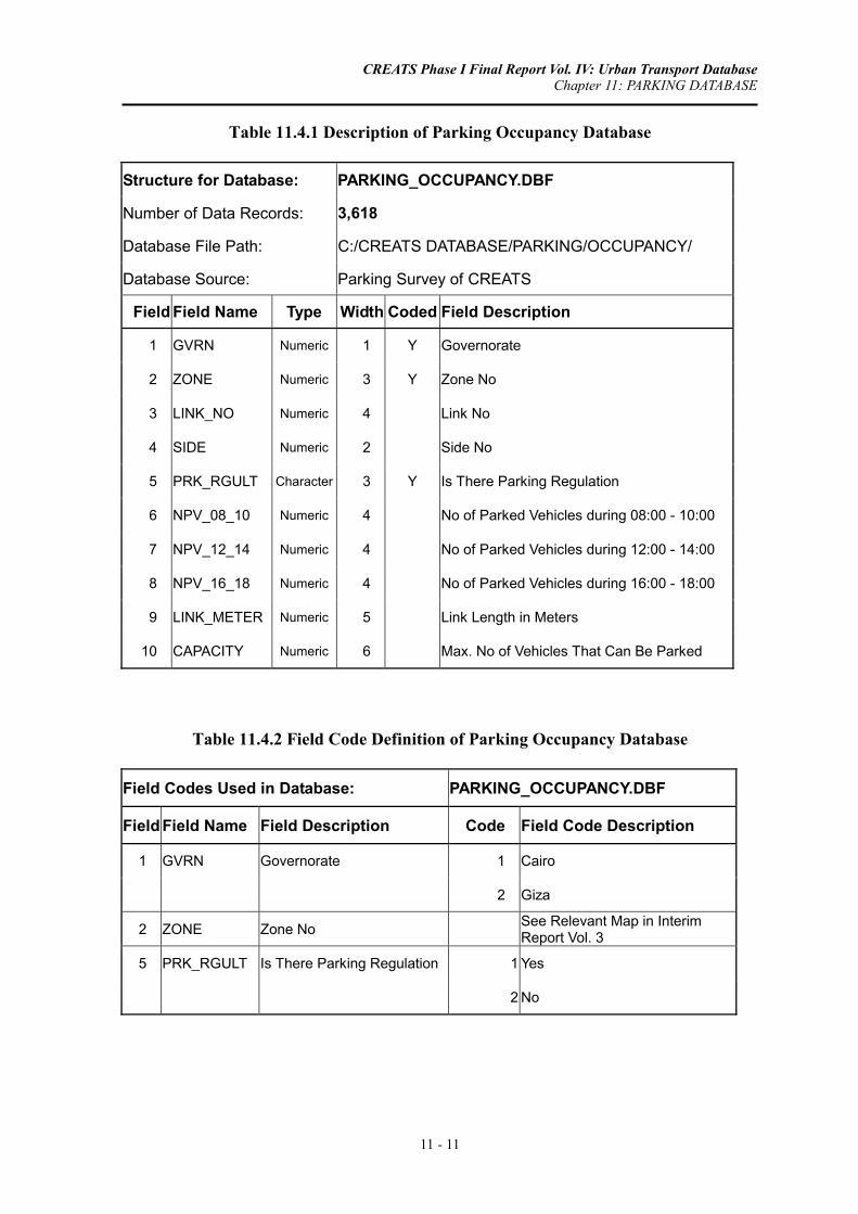
CREATS Phase I Final Report Vol. IV: Urban Transport Database Chapter 11: PARKING DATABASE
11 - 11
Table 11.4.1 Description of Parking Occupancy Database
Structure for Database: PARKING_OCCUPANCY.DBF
Number of Data Records: 3,618
Database File Path: C:/CREATS DATABASE/PARKING/OCCUPANCY/
Database Source: Parking Survey of CREATS
Field Field Name Type Width Coded Field Description
1 GVRN Numeric 1 Y Governorate
2 ZONE Numeric 3 Y Zone No
3 LINK_NO Numeric 4 Link No
4 SIDE Numeric 2 Side No
5 PRK_RGULT Character 3 Y Is There Parking Regulation
6 NPV_08_10 Numeric 4 No of Parked Vehicles during 08:00 - 10:00
7 NPV_12_14 Numeric 4 No of Parked Vehicles during 12:00 - 14:00
8 NPV_16_18 Numeric 4 No of Parked Vehicles during 16:00 - 18:00
9 LINK_METER Numeric 5 Link Length in Meters
10 CAPACITY Numeric 6 Max. No of Vehicles That Can Be Parked
Table 11.4.2 Field Code Definition of Parking Occupancy Database
Field Codes Used in Database: PARKING_OCCUPANCY.DBF
Field Field Name Field Description Code Field Code Description
1 GVRN Governorate 1 Cairo
2 Giza
2 ZONE Zone No See Relevant Map in Interim Report Vol. 3
5 PRK_RGULT Is There Parking Regulation 1 Yes
2 No

CREATS Phase I Final Report Vol. IV: Urban Transport Database Chapter 12: ENVIRONMENTAL DATABASE
12 - 1
CHAPTER 12: ENVIRONMENTAL DATABASE
The Environmental Survey was one of the 11 traffic Surveys carried out within CREATS study area. The objective of environmental survey was to address the major environmental problems that agonize the Study Area in relation to the existing traffic situation.
The Environmental Survey consisted of three components:
• Environmental Awareness Survey (EAS).
• Air Quality Survey.
• Noise level Survey.
The Environmental Awareness Survey was proposed additionally to identify the awareness of residents living in the Study Area of environmental problems and issues related to traffic, so that the information obtained from this Survey will contribute to the consensus formation of the Master Plan.
Guiding principles in designing the Environmental Surveys were:
• Compliance with the preliminary work program outlined in the inception report.
• Observation of logistic constraints with respect to the availability of monitoring equipment and mobile stations.
• Reliability of results to be expected.
• Significance of data to serve as a basis for planning and management options to be incorporated into the Master Plan.
12.1 ENVIRONMENTAL AWARENESS SURVEY (EAS) DATABASE
12.1.1 Overview
An Environmental Awareness Survey (EAS) was included in the environmental component of the Cairo Regional Area Transportation Study (CREATS). From 3 to 8 November 2001 the Environmental Awareness Survey was carried out in the residential area inside the Ring Road of Cairo. The major objective of this Survey

CREATS Phase I Final Report Vol. IV: Urban Transport Database Chapter 12: ENVIRONMENTAL DATABASE
12 - 2
was to obtain actual baseline data on residents of Cairo and to investigate the perception of the interviewed people of environmental issues related to the traffic situation in Cairo.
More specifically, the objectives of the Environmental Awareness Survey were:
• To obtain the perception of residents of Cairo of traffic-related environmental problems.
• To determine the magnitude of problems, at the individual perception level, related to Cairo's traffic conditions.
• To identify the main concerns and aspirations of the public related to environmentally sound planning of traffic projects and project alternatives.
• To identify the degree of willingness of residents of Cairo to contribute to the solution of major environmental problems associated with the transport sector.
For practical and logistic reasons it was agreed to separate the Environmental Awareness Survey from the Traffic Household Survey under this project. Instead, a sub-sample of 1000 households, distributed among different (but representative) zones of Cairo, was selected where a team of trained interviewers conducted the Survey, using the questionnaire presented in the Appendix.
A sample of 1,036 residents were interviewed during EAS within the boundaries of the Ring Road. The selection of the interviewed households in each zone was done following the random sampling procedure used in HIS.
Actual execution of the EAS started on 3 and ended on 8 November 2001. Two groups were working separately, each group composed of 22 surveyors led by a supervisor
12.1.2 Environment Awareness Survey (EAS) Database Structure
The EAS was performed using two survey forms. The output of the first survey form 1 was housed in a database file “EAS_FORM1.DBF”, which comprising 1,036 interview records as shown in Table 11.1.1. This file contains information regarding household characteristics, e.g., household size, number of working and students members by gender, type of place of residence, total monthly income, vehicle ownership, fuel consumption and parking place. The residence place type was elaborated in addition to other fields in Table 11.1.2.
The second survey form was used to identify the following topics:
• Level of perception of environmental problems attributed to traffic development.
• Degree of annoyance attributed to traffic conditions, poor air quality and noise.
CREATS Phase I Final Report Vol. IV: Urban Transport Database Chapter 12: ENVIRONMENTAL DATABASE
12 - 3
• Personal ailments/diseases/disorders/complaints attributed to traffic conditions, poor air quality and noise level.
• Perception of causes and solutions to solve key environmental problems related to traffic.
• Degree of willingness to contribute to solutions for major environmental problems related to traffic.
• Degree of willingness to change behavioral patterns in relation to traffic problems.
Table 11.1.3 presents the collected data fields in the standard file format, which include the abovementioned items in addition to person characteristics (sex, age, occupation and education level). Almost all data fields are coded, which have to be included in the second description table (see Table 11.1.4). For instance, occupation and education level have been classified into 14 and 4 classes, respectively.
It should be noted that some fields may have the same definitions of their codes. In such a case, the field code description is mentioned for all of them once. For example, fields 7 to 18 of Table 11.1.4 have the same field code description (1 = Yes, 2 = No and 3 = No answer).
12.2 NOISE SURVEY DATABASE
12.2.1 Overview
A Noise Level Survey has been one of the components of the Environmental Survey Program, intended to assess the actual noise levels in the Study Area.
The measurements were carried out at 15 Survey Locations, in such a way that the streets, districts and suburbs – inside the Ring Road of Cairo – would be well represented. Actually, each Survey Location consisted of two Locations “A” and “B”, at a distance of each other of 100 to 1000 meters. The “A” Locations being the main location and the “B” Locations being the “background locations”.
The Survey Locations A and B were selected to represent:
A: the relatively polluted and “noisy” locations along the main roads in Cairo;
B: the less polluted and quieter locations in nearby residential areas, off the main roads (also called: background location).
Noise was measured once a week on a working day i.e. one of the three days: Monday, Tuesdays, or Wednesdays. The measurements were always carried out simultaneously on both the main (“A”) and background (“B”) locations.
The survey parameters included:
CREATS Phase I Final Report Vol. IV: Urban Transport Database Chapter 12: ENVIRONMENTAL DATABASE
12 - 4
• L(A)eq - L(A)10
• L(A)max - L(A)50
• L(A)min - L(A)90
The field survey schedule defined for a weekday was: 10 minutes of measuring every hour for 24 hours (i.e., 50 minutes interval).
12.2.2 Noise Survey Database Structure
The noise data has been kept in the standard file structure format, which includes 726 records as indicated in Table 11.2.1. The survey location code, survey date, measurement time (hour, minute and second) and the above survey parameters are included in this database. Only the field of survey locations has to be detailed in Table 11.2.2 to list 15 survey locations, which are divided into A and B each.
12.3 AIR POLLUTION SURVEY DATABASE
12.3.1 Overview
At the 30 (15 A and 15 B Survey Locations) Survey Locations in Cairo, the following parameters were measured:
• NO2, SO2, CO, HC, NMHC, CH4. • PM10 and PM2.5. • Ambient air temperature. • Relative humidity. • Barometric pressure.
At the 15 Survey Locations A above parameters were measured for 24 hours continuously, during 7 days.
The 15 Survey Locations B were measured during 2 days on representative weekdays (a “peak day” and an “off-peak day”) continuously for 24 hours. The reason for this schedule is that the emission of major air pollutants in Cairo has a pronounced weekly fluctuation. The common pattern is that in Cairo Fridays (and to some extent Saturdays) are the days with the least concentration of air pollutants (off-peak days), while Mondays, Tuesdays, and Wednesdays show the peaks in air pollution (peak days).
12.3.2 Air Pollution Survey Database Structure
Air pollution measurements have organized in one database file “AIR POLLUTION.DBF”, which consists of 3,204 records as shown in Table 11.3.1. The names of survey locations are specified in Table 11.3.2.

CREATS Phase I Final Report Vol. IV: Urban Transport Database Chapter 12: ENVIRONMENTAL DATABASE
12 - 5
Table 12.1.1 Description of Environment Awareness Survey Database (Form 1)
Structure for Database: EAS_FORM1.DBF
Number of Data Records: 1,036
Database File Path: C:/CREATS DATABASE/INVIRONMENT/EAS/
Database Source: Environmental Awareness Survey of CREATS
Field Field Name Type Width Coded Field Description 1 SMPL_NO Numeric 7 Sample ID 2 QISM_ID Numeric 5 Y Qism Code 3 SHKH_ID Numeric 3 Y Shiakha Code 4 MALE_TOT Numeric 3 Total No. of Male Persons per Household 5 MALE_EMP Numeric 2 No. of Male Employees per Household 6 MALE_STD Numeric 2 No. of Male Students per Household 7 MALE_OTH Numeric 2 No. of Other Males per Household 8 FMAL_TOT Numeric 3 Total No. of Female Persons per Household 9 FMAL_EMP Numeric 2 No. of Female Employees per Household
10 FMAL_STD Numeric 2 No. of Female Students per Household 11 FMAL_OTH Numeric 2 No. of Other Females per Household 12 HH_6YR Numeric 3 No. of Household Members > 6 Years 13 OWN_VEH Numeric 2 Do you own Motorized Vehicles 14 MCYC_STR Numeric 3 No. of Owned Motorcycles & Parked on-Street 15 MCYC_GRG Numeric 3 No. of Owned Motorcycles & Parked off-Street 16 MCYC_FUEL Numeric 4 Fuel Consumption of Motorcycle (LE/Month) 17 AUTO_STR Numeric 3 No. of Owned Private Cars & Parked on-Street 18 AUTO_GRG Numeric 3 No. of Owned Private Cars & Parked off-Street 19 AUTO_FUEL Numeric 3 Fuel Consumption of Private Car (LE/Month) 20 PKUP_STR Numeric 3 No. of Owned Pickups & Parked on-Street 21 PKUP_GRG Numeric 3 No. of Owned Pickups & Parked off-Street 22 PKUP_FUEL Numeric 4 Fuel Consumption of Pickup (LE/Month) 23 TAXI_STR Numeric 3 No. of Owned Taxis & Parked on-Street 24 TAXI_GRG Numeric 3 No. of Owned Taxis & Parked off-Street 25 TAXI_FUEL Numeric 4 Fuel Consumption of Taxi (LE/Month) 26 SHTX_STR Numeric 3 No. of Owned Shared Taxis & Parked on-Street 27 SHTX_GRG Numeric 3 No. of Owned Shared Taxis & Parked off-Street 28 SHTX_FUEL Numeric 4 Fuel Consumption of Shared Taxi (LE/Month) 29 TRUK_STR Numeric 3 No. of Owned Trucks & Parked on-Street 30 TRUK_GRG Numeric 3 No. of Owned Trucks & Parked off-Street 31 TRUK_FUEL Numeric 4 Fuel Consumption of Truck (LE/Month) 32 HOUS_TYP Numeric 2 Y Type of Residence Place
33 NO_ROOMS Numeric 2 No. of Rooms plus Living Room in Residence Place
34 ELCTRCTY Numeric 5 Value of Monthly Electricity Consumption (LE)
35 TEL_BILL Numeric 6 Value of Telephone Bill during the last 6 Months (LE)
36 HH_INCM Numeric 2 Total Monthly Income per HH 37 AIR_COND Numeric 2 Y Do You Have an Air Condition 38 SATLT_TV Numeric 2 Y Do You Have an Satellite TV 39 NO_MOBILE Numeric 2 No of Mobile Phones Owned by HH 40 MOBIL_BILL Numeric 5 Value of Mobile Phones Bill per Months (LE)

CREATS Phase I Final Report Vol. IV: Urban Transport Database Chapter 12: ENVIRONMENTAL DATABASE
12 - 6
Table 12.1.2 Field Code Definition of Environment Awareness Survey Database (Form 1)
Field Codes Used in Database: EAS_FORM1.DBF
Field Field Name Field Description Code Field Code Description 2 QISM_ID Qism Code Y See Equivalence Table ….. 3 SHKH_ID Shiakha Code Y See Equivalence Table ….. 32 HOUS_TYP Type of Residence Place 1 Owned Villa 2 Rented Villa 3 Owned Apartment 4 Rented Apartment 5 Shared Apartment 6 Rural House 7 Improvised / Temporary Hut 8 Other 9 No Answer
37 AIR_COND Do You Have an Air Condition 1 Yes 2 No
38 SATLT_TV Do You Have an Satellite TV 1 Yes 2 No

CREATS Phase I Final Report Vol. IV: Urban Transport Database Chapter 12: ENVIRONMENTAL DATABASE
12 - 7
Table 12.1.3 Description of Environment Awareness Survey Database (Form 2)
Structure for Database: EAS_FORM2.DBF
Number of Data Records: 1,036
Database File Path: C:/CREATS DATABASE/INVIRONMENT/EAS/
Database Source: Environmental Awareness Survey of CREATS
Field Field Name Type Width Coded Field Description 1 SMPL_NO Numeric 7 Sample ID 2 SEX Numeric 2 Y Sex 3 AGE Numeric 2 Y Age 4 OCCUP Numeric 3 Y Occupation 5 EDUC_LEVL Numeric 2 Y Education Level 6 AIR_POLL Numeric 2 Y Air Pollution in the Last 20 Years 7 BLACK_SPOT Numeric 2 Y Main Traffic Problems: Congestion at Black Spots
8 HEALTH Numeric 2 Y Main Traffic Problems: Health is Affected by Daily Exposure
9 VEH_SMOK Numeric 2 Y Main Traffic Problems: Exposure to Vehicle Smoke 10 NOISE_EXP Numeric 2 Y Main Traffic Problems: Exposure to Vehicle Noise 11 ACC_RISK Numeric 2 Y Main Traffic Problems: Accident Risk 12 SAF_PEDST Numeric 2 Y Main Traffic Problems: Safe Pedestrian Passenger 13 EN_PARKING Numeric 2 Y Main Traffic Problems: Enough Parking Places 14 TRF_POLIC Numeric 2 Y Main Traffic Problems: Controls by Traffic Police
15 ECON_ACTIV Numeric 2 Y Main Traffic Problems: Economic Activities are Negatively Influenced
16 PORB_NON1 Numeric 2 Y Main Traffic Problems: Non 17 TRF_OTHER Numeric 2 Y Main Traffic Problems: Others 18 NOT_FAMLR1 Numeric 2 Y Main Traffic Problems: Not Familiar 19 ALIMNENTS Numeric 2 Y Suffer from Respiratory Ailments 20 NIOSE_LVL Numeric 2 Y Suffer from High Noise Levels 21 INCR_VEH Numeric 2 Y Pollution is a Result of: Increased Number of Vehicles
22 INCR_AUTO Numeric 2 Y Pollution is a Result of: Increased Number of Private Cars
23 INDS_DEVLP Numeric 2 Y Pollution is a Result of: Industrial Development 24 INDS_POLL Numeric 2 Y Pollution is a Result of: Control of Heavy Industries 25 OLD_VEH Numeric 2 Y Pollution is a Result of: Old Vehicles 26 DRIV_HABT Numeric 2 Y Pollution is a Result of: Driving Habits 27 DRIV_TRAIN Numeric 2 Y Pollution is a Result of: Insufficient Training 28 CHECKUP Numeric 2 Y Pollution is a Result of: Insufficient Checkups
29 POLL_LAW Numeric 2 Y Pollution is a Result of: Insufficient Laws for Traffic Pollution
30 TRAF_LAW Numeric 2 Y Pollution is a Result of: Insufficient Traffic Regulations31 QLTY_MONTR Numeric 2 Y Pollution is a Result of: Monitoring of Air Quality 32 GEOG_SIT Numeric 2 Y Pollution is a Result of: Geographic Situation 33 LACK_PLAN Numeric 2 Y Pollution is a Result of: Lack of Planning 34 SAND_PRTCL Numeric 2 Y Pollution is a Result of: Sand Particles 35 CONSTR_WR Numeric 2 Y Pollution is a Result of: Construction Works

CREATS Phase I Final Report Vol. IV: Urban Transport Database Chapter 12: ENVIRONMENTAL DATABASE
12 - 8
Table 12.1.3 Description of Environment Awareness Survey Database (Form 2), Continued
Structure for Database: EAS_FORM2.DBF
Number of Data Records: 1,036
Database File Path: C:/CREATS DATABASE/INVIRONMENT/EAS/
Database Source: Environmental Awareness Survey of CREATS
Field Field Name Type Width Coded Field Description 36 RICE_HAY Numeric 2 Y Pollution is a Result of: Rice Hay
37 NO_POLL Numeric 2 Y Pollution is a Result of: I Don't Think Air Quality Is Poor
38 POLL_OTHER Numeric 2 Y Pollution is a Result of: Others 39 NOT_FAMLR2 Numeric 2 Y Pollution is a Result of: Not Familiar 40 ACDNT_INCR Numeric 2 Y Accident Rates Increase 41 ACDNT_SAME Numeric 2 Y Accident Rates Remain the Same 42 GOOD_TRIAN Numeric 2 Y Accident: Better Training 43 POLIC_CTRL Numeric 2 Y Accident: Intensify Traffic Police Controls 44 SPD_PNLTY Numeric 2 Y Accident: Higher Speeding Penalties 45 PDSTR_PASS Numeric 2 Y Accident: Safer Pedestrian Passages 46 AMBULANCE Numeric 2 Y Accident: Better Ambulance 47 NOT_FAMLR3 Numeric 2 Y Accident: Not Familiar 48 VEH_CHECK Numeric 2 Y Stricter Vehicle Checks
49 NOT_SOLVE Numeric 2 Y Reduce Private Cars: Would not Solve the Problem
50 RED_CONGS Numeric 2 Y Reduce Private Cars: Would Reduce Congestion
51 LESS_POLL Numeric 2 Y Reduce Private Cars: Less Cars Would Reduce Pollution
52 SOC_INCNTV Numeric 2 Y Reduce Private Cars: Social and Economic Incentive
53 PC_OTHER Numeric 2 Y Reduce Private Cars: Others 54 NOT_FAMLR4 Numeric 2 Y Reduce Private Cars: Not Familiar 55 CAR_ALT Numeric 2 Y Alternative to Private Cars 56 CNG_KNOW Numeric 2 Y Do you Know CNG Cars 57 CNG_CNVRT Numeric 2 Y Convert to CNG 58 HIGH_COST Numeric 2 Y Why not Convert: High Cost 59 ENG_PROB Numeric 2 Y Why not Convert: Engine Problems 60 LONG_QUE Numeric 2 Y Why not Convert: Queuing at Filling Stations 61 SAFETY Numeric 2 Y Why not Convert: Safety 62 CNG_OTHER Numeric 2 Y Why not Convert: Others 63 CONVENIENT Numeric 2 Y Use Car Less: More Convenient 64 CHEAPER Numeric 2 Y Use Car Less: Cheaper 65 ATTRACTIVE Numeric 2 Y Use Car Less: More Attractive 66 FASTER Numeric 2 Y Use Car Less: Faster 67 PRSN_FREE Numeric 2 Y Use Car Less: Personal Freedom

CREATS Phase I Final Report Vol. IV: Urban Transport Database Chapter 12: ENVIRONMENTAL DATABASE
12 - 9
Table 12.1.4 Field Code Definition of Environment Awareness Survey Database (Form 2)
Field Codes Used in Database: EAS_FORM2.DBF
Field Field Name Field Description Code Field Code Description
2 SEX Sex 1 Male 2 Female 3 AGE Age 1 7 - 9 years 2 10 - 19 years 3 20 - 29 years 4 30 - 39 years 5 40 - 49 years 6 50 - 60 years 7 More than 60 years 9 No Answer 4 OCCUP Occupation 1 Administration 2 Professional 3 Tech/ Assist 4 Clerk 5 Sales/Service 6 Farmer/fisher 7 Craftsman 8 Production 9 Unskilled 10 Student 11 Housewife 12 Retired 13 Jobless 14 Others 99 No Answer 5 EDUC_LEVL Education Level 1 University Graduate or Higher 2 High School or Diploma 3 Preparatory or Secondary School 4 None
6 AIR_POLL Air Pollution in the Last 20 Years 1 Increased Each Year
2 Remained the Same 3 Decreased 4 I am Not Familiar
CREATS Phase I Final Report Vol. IV: Urban Transport Database Chapter 12: ENVIRONMENTAL DATABASE
12 - 10
Table 12.1.4 Field Code Definition of Environment Awareness Survey Database (Form 2), Continued
Field Codes Used in Database: EAS_FORM2.DBF
Field Field Name Field Description Code Field Code Description
7 BLACK_SPOT Main Traffic Problems: Congestion at Black Spots 1 Yes
8 HEALTH Main Traffic Problems: Health is Affected by Daily Exposure 2 No
9 VEH_SMOK Main Traffic Problems: Exposure to Vehicle Smoke 9 No Answer
10 NOISE_EXP Main Traffic Problems: Exposure to Vehicle Noise
11 ACC_RISK Main Traffic Problems: Accident Risk
12 SAF_PEDST Main Traffic Problems: Safe Pedestrian Passenger
13 EN_PARKING Main Traffic Problems: Enough Parking Places
14 TRF_POLIC Main Traffic Problems: Controls by Traffic Police
15 ECON_ACTIV Main Traffic Problems: Economic Activities are Negatively Influenced
16 PORB_NON1 Main Traffic Problems: Non 17 TRF_OTHER Main Traffic Problems: Others 18 NOT_FAMLR1 Main Traffic Problems: Not Familiar
19 ALIMNENTS Suffer from Respiratory Ailments 1 No, Although We Daily Pass Congested Area
2 No, Because We Live Far Away from Such Areas
3 Yes, We Sometimes Suffer from These Symptoms
4 Yes, We often Suffer from These Symptoms
5 I am Not Familiar
20 NIOSE_LVL Suffer from High Noise Levels 1 No, Although We Daily Pass Congested Area
2 No, Because We Live Far Away from Such Areas
3 Yes, We Sometimes Suffer from Hearing Impairment Symptoms
4 Yes, We often Suffer from Other Symptoms
5 I am Not Familiar
21 INCR_VEH Pollution is a Result of: Increased Number of Vehicles 1 Yes
22 INCR_AUTO Pollution is a Result of: Increased Number of Private Cars 2 No
23 INDS_DEVLP Pollution is a Result of: Industrial Development 9 No Answer
24 INDS_POLL Pollution is a Result of: Control of Heavy Industries
25 OLD_VEH Pollution is a Result of: Old Vehicles

CREATS Phase I Final Report Vol. IV: Urban Transport Database Chapter 12: ENVIRONMENTAL DATABASE
12 - 11
Table 12.1.4 Field Code Definition of Environment Awareness Survey Database (Form 2), Continued
Field Codes Used in Database: EAS_FORM2.DBF
Field Field Name Field Description Code Field Code Description
26 DRIV_HABT Pollution is a Result of: Driving Habits 1 Yes
27 DRIV_TRAIN Pollution is a Result of: Insufficient Training 2 No
28 CHECKUP Pollution is a Result of: Insufficient Checkups 9 No Answer
29 POLL_LAW Pollution is a Result of: Insufficient Laws for Traffic Pollution
30 TRAF_LAW Pollution is a Result of: Insufficient Traffic Regulations
31 QLTY_MONTR Pollution is a Result of: Monitoring of Air Quality
32 GEOG_SIT Pollution is a Result of: Geographic Situation
33 LACK_PLAN Pollution is a Result of: Lack of Planning
34 SAND_PRTCL Pollution is a Result of: Sand Particles
35 CONSTR_WRK Pollution is a Result of: Construction Works
36 RICE_HAY Pollution is a Result of: Rice Hay
37 NO_POLL Pollution is a Result of: I Don't Think Air Quality Is Poor
38 POLL_OTHER Pollution is a Result of: Others 39 NOT_FAMLR2 Pollution is a Result of: Not Familiar 40 ACDNT_INCR Accident Rates Increase 41 ACDNT_SAME Accident Rates Remain the Same 42 GOOD_TRIAN Accident: Better Training
43 POLIC_CTRL Accident: Intensify Traffic Police Controls
44 SPD_PNLTY Accident: Higher Speeding Penalties 45 PDSTR_PASS Accident: Safer Pedestrian Passages 46 AMBULANCE Accident: Better Ambulance 47 NOT_FAMLR3 Accident: Not Familiar 48 VEH_CHECK Stricter Vehicle Checks 1 Yes, and I am willing to Pay
2 Yes, Only If The Government Fully Subsidize It
3 No, I Consider This Too Expensive
4 No, I Don't Think This Would Solve The Problem Of Air Pollution In Cairo
5 Yes, Only If The Government Partially Subsidize It
6 Others 9 No Answer
CREATS Phase I Final Report Vol. IV: Urban Transport Database Chapter 12: ENVIRONMENTAL DATABASE
12 - 12
Table 12.1.4 Field Code Definition of Environment Awareness Survey Database (Form 2), Continued
Field Codes Used in Database: EAS_FORM2.DBF
Field Field Name Field Description Code Field Code Description
49 NOT_SOLVE Reduce Private Cars: Would not Solve the Problem 1 Yes
50 RED_CONGS Reduce Private Cars: Would Reduce Congestion 2 No
51 LESS_POLL Reduce Private Cars: Less Cars Would Reduce Pollution 9 No Answer
52 SOC_INCNTV Reduce Private Cars: Social and Economic Incentive
53 PC_OTHER Reduce Private Cars: Others
54 NOT_FAMLR4 Reduce Private Cars: Not Familiar
55 CAR_ALT Alternative to Private Cars
56 CNG_KNOW Do you Know CNG Cars
57 CNG_CNVRT Convert to CNG
58 HIGH_COST Why not Convert: High Cost
59 ENG_PROB Why not Convert: Engine Problems
60 LONG_QUE Why not Convert: Queuing at Filling Stations
61 SAFETY Why not Convert: Safety
62 CNG_OTHER Why not Convert: Others
63 CONVENIENT Use Car Less: More Convenient
64 CHEAPER Use Car Less: Cheaper
65 ATTRACTIVE Use Car Less: More Attractive
66 FASTER Use Car Less: Faster
67 PRSN_FREE Use Car Less: Personal Freedom
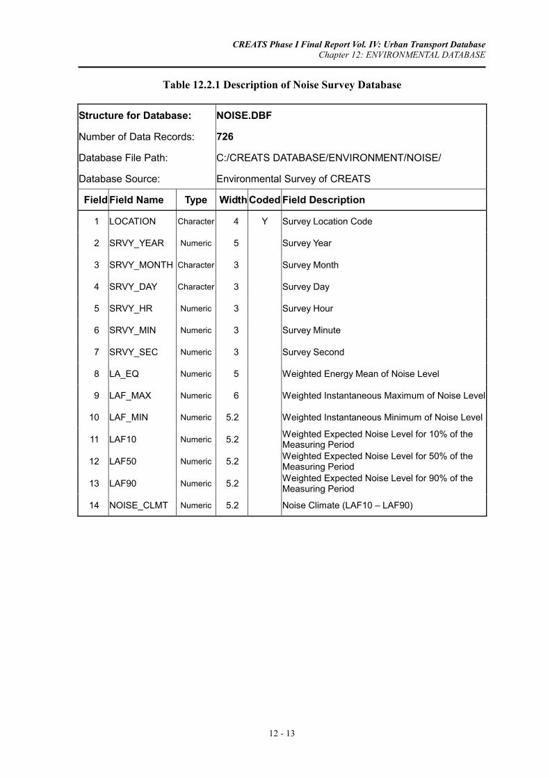
CREATS Phase I Final Report Vol. IV: Urban Transport Database Chapter 12: ENVIRONMENTAL DATABASE
12 - 13
Table 12.2.1 Description of Noise Survey Database
Structure for Database: NOISE.DBF
Number of Data Records: 726
Database File Path: C:/CREATS DATABASE/ENVIRONMENT/NOISE/
Database Source: Environmental Survey of CREATS
Field Field Name Type Width Coded Field Description
1 LOCATION Character 4 Y Survey Location Code
2 SRVY_YEAR Numeric 5 Survey Year
3 SRVY_MONTH Character 3 Survey Month
4 SRVY_DAY Character 3 Survey Day
5 SRVY_HR Numeric 3 Survey Hour
6 SRVY_MIN Numeric 3 Survey Minute
7 SRVY_SEC Numeric 3 Survey Second
8 LA_EQ Numeric 5 Weighted Energy Mean of Noise Level
9 LAF_MAX Numeric 6 Weighted Instantaneous Maximum of Noise Level
10 LAF_MIN Numeric 5.2 Weighted Instantaneous Minimum of Noise Level
11 LAF10 Numeric 5.2 Weighted Expected Noise Level for 10% of the Measuring Period
12 LAF50 Numeric 5.2 Weighted Expected Noise Level for 50% of the Measuring Period
13 LAF90 Numeric 5.2 Weighted Expected Noise Level for 90% of the Measuring Period
14 NOISE_CLMT Numeric 5.2 Noise Climate (LAF10 – LAF90)

CREATS Phase I Final Report Vol. IV: Urban Transport Database Chapter 12: ENVIRONMENTAL DATABASE
12 - 14
Table 12.2.2 Field Code Definition of Noise Survey Database
Field Codes Used in Database: NOISE.DBF
Field Field Name Field Description Code Field Code Description
1 LOCATION Survey Location Code 1 Cairo - Alexandria Agricultural Road South of Ring Road
2 Intersection of Port Said Street and Sawah Street
3 Shobra Street South of Khalafawy Square
4 Port Said Street South of Seket El Wayly Street
5 Orooba Street Near Military Academy
6 Intersection of Batal Ahmed Abdel Aziz and 6th of October Expressway
7 Abdel Moniem Reyad Square
8 Bab El Shaareya Square
9 Nasr Road North of 6th of October Expressway
10 Nasr Road East of Nozha Street
11 Malek Feisal Street West of El Nady Street
12 Giza Square
13 Fom El Khaleeg Square
14 Autostrade Road South of Citadel
15 Korniesh Road North of Moneeb Bridge
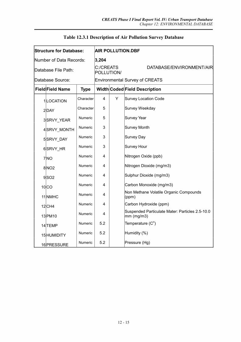
CREATS Phase I Final Report Vol. IV: Urban Transport Database Chapter 12: ENVIRONMENTAL DATABASE
12 - 15
Table 12.3.1 Description of Air Pollution Survey Database
Structure for Database: AIR POLLUTION.DBF
Number of Data Records: 3,204
Database File Path: C:/CREATS DATABASE/ENVIRONMENT/AIR POLLUTION/
Database Source: Environmental Survey of CREATS
Field Field Name Type Width Coded Field Description
1 LOCATION Character 4 Y Survey Location Code
2 DAY Character 5 Survey Weekday
3 SRVY_YEAR Numeric 5 Survey Year
4 SRVY_MONTH Numeric 3 Survey Month
5 SRVY_DAY Numeric 3 Survey Day
6 SRVY_HR Numeric 3 Survey Hour
7 NO Numeric 4 Nitrogen Oxide (ppb)
8 NO2 Numeric 4 Nitrogen Dioxide (mg/m3)
9 SO2 Numeric 4 Sulphur Dioxide (mg/m3)
10 CO Numeric 4 Carbon Monoxide (mg/m3)
11 NMHC Numeric 4 Non Methane Volatile Organic Compounds (ppm)
12 CH4 Numeric 4 Carbon Hydroxide (ppm)
13 PM10 Numeric 4 Suspended Particulate Mater: Particles 2.5-10.0 mm (mg/m3)
14 TEMP Numeric 5.2 Temperature (Co)
15 HUMIDITY Numeric 5.2 Humidity (%)
16 PRESSURE Numeric 5.2 Pressure (Hg)

CREATS Phase I Final Report Vol. IV: Urban Transport Database Chapter 12: ENVIRONMENTAL DATABASE
12 - 16
Table 12.3.2 Field Code Definition of Noise Survey Database
Field Codes Used in Database: AIR POLLUTION.DBF
Field Field Name Field Description Code Field Code Description
1 LOCATION Survey Location Code 1 Cairo - Alexandria Agricultural Road South of Ring Road
2 Intersection of Port Said Street and Sawah Street
3 Shobra Street South of Khalafawy Square
4 Port Said Street South of Seket El Wayly Street
5 Orooba Street Near Military Academy
6 Intersection of Batal Ahmed Abdel Aziz and 6th of October Expressway
7 Abdel Moniem Reyad Square
8 Bab El Shaareya Square
9 Nasr Road North of 6th of October Expressway
10 Nasr Road East of Nozha Street
11 Malek Feisal Street West of El Nady Street
12 Giza Square
13 Fom El Khaleeg Square
14 Autostrade Road South of Citadel
15 Korniesh Road North of Moneeb Bridge