
Chapter 6 Recreation - BPA.gov Volume 1/Chapter 6... · Chapter 6 Recreation ... ATV use,...
30
I-5 Corridor Reinforcement Project Draft EIS 6-1 November 2012 Words in bold and acronyms are defined in Chapter 32, Glossary and Acronyms. Chapter 6 Recreation This chapter describes existing recreation resources in the project area, and how the project alternatives could affect these resources. Related information can be found in Chapter 5, Land and Chapter 7, Visual Resources. Economic values of recreation in the project area are discussed in Chapter 11, Socioeconomics. 6.1 Affected Environment Recreation resources are found in both urban and rural portions of the project area within Cowlitz and Clark counties, Washington, and Multnomah County, Oregon. These resources include urban parks and greenways, developed facilities in rural areas such as campgrounds or trailheads, and undeveloped rural areas. Recreational activities within the three counties include boating, fishing, hunting, target practice, camping, hiking, swimming, picnicking, sports games, wildlife watching, ATV use, sightseeing, horseback riding, and mountain biking. These activities occur in dedicated areas such as parks and other developed recreation facilities, on motorized and non-motorized trails, and in dispersed areas such as open space (see Maps 6-1A through 6-1E). Although these maps show recreation resources throughout the project area, for this analysis, a study area for recreation resources was identified to include a 2000-foot—wide corridor along the entire route of each action alternative, 1,000 feet on either side of the transmission line centerline. This study area includes all project facilities. In the western and southern portions of the study area, recreation resources are closely spaced, urban, and generally more fragmented. In the eastern portion, recreation resources tend to be larger, more contiguous, and more rural. There are many recreation resources scattered throughout Cowlitz, Clark, and Multnomah counties outside of the study area (see Maps 6-1A through 6-1E). Recreation resources within the study area are owned by public and private entities within Cowlitz, Clark, and Multnomah counties, and the cities of Castle Rock, Vancouver, Camas, Washougal, Fairview, and Troutdale. These resources are managed under the following plans: Cowlitz County Comprehensive Park Plan Update (Cowlitz County 2010b) Cowlitz Regional Trails Plan (Cowlitz-Wahkiakum Council of Governments (CWCOG) 2006) Vancouver-Clark Comprehensive Parks, Recreation and Open Space Plan (Vancouver- Clark Parks and Recreation Department 2007) Final Recreation Resource Management Plan, Lewis River Hydroelectric Projects Federal Energy Regulatory Commission (FERC) Project Nos. 935, 2071 and 2111 (EDAW, Inc. and PacifiCorp 2008) Western Yacolt Burn Forest Recreation Plan (WDNR 2010a) City of Troutdale, Parks Master Plan (City of Troutdale 2006)
Transcript of Chapter 6 Recreation - BPA.gov Volume 1/Chapter 6... · Chapter 6 Recreation ... ATV use,...
I-5 Corridor Reinforcement Project Draft EIS 6-1 November 2012
Words in bold and acronyms are defined in Chapter 32, Glossary and Acronyms.
Chapter 6 Recreation This chapter describes existing recreation resources in the project area, and how the project alternatives could affect these resources. Related information can be found in Chapter 5, Land and Chapter 7, Visual Resources. Economic values of recreation in the project area are discussed in Chapter 11, Socioeconomics.
6.1 Affected Environment
Recreation resources are found in both urban and rural portions of the project area within Cowlitz and Clark counties, Washington, and Multnomah County, Oregon. These resources include urban parks and greenways, developed facilities in rural areas such as campgrounds or trailheads, and undeveloped rural areas. Recreational activities within the three counties include boating, fishing, hunting, target practice, camping, hiking, swimming, picnicking, sports games, wildlife watching, ATV use, sightseeing, horseback riding, and mountain biking. These activities occur in dedicated areas such as parks and other developed recreation facilities, on motorized and non-motorized trails, and in dispersed areas such as open space (see Maps 6-1A through 6-1E).
Although these maps show recreation resources throughout the project area, for this analysis, a study area for recreation resources was identified to include a 2000-foot—wide corridor along the entire route of each action alternative, 1,000 feet on either side of the transmission line centerline. This study area includes all project facilities.
In the western and southern portions of the study area, recreation resources are closely spaced, urban, and generally more fragmented. In the eastern portion, recreation resources tend to be larger, more contiguous, and more rural. There are many recreation resources scattered throughout Cowlitz, Clark, and Multnomah counties outside of the study area (see Maps 6-1A through 6-1E).
Recreation resources within the study area are owned by public and private entities within Cowlitz, Clark, and Multnomah counties, and the cities of Castle Rock, Vancouver, Camas, Washougal, Fairview, and Troutdale. These resources are managed under the following plans:
Cowlitz County Comprehensive Park Plan Update (Cowlitz County 2010b)
Cowlitz Regional Trails Plan (Cowlitz-Wahkiakum Council of Governments (CWCOG) 2006)
Vancouver-Clark Comprehensive Parks, Recreation and Open Space Plan (Vancouver-Clark Parks and Recreation Department 2007)
Final Recreation Resource Management Plan, Lewis River Hydroelectric Projects Federal Energy Regulatory Commission (FERC) Project Nos. 935, 2071 and 2111 (EDAW, Inc. and PacifiCorp 2008)
Western Yacolt Burn Forest Recreation Plan (WDNR 2010a)
City of Troutdale, Parks Master Plan (City of Troutdale 2006)

Chapter 6 Recreation
6-2 I-5 Corridor Reinforcement Project Draft EIS November 2012
City of Camas; Park, Recreation and Open Space Comprehensive Plan (City of Camas 2007)
City of Fairview Comprehensive Plan (City of Fairview 2004)
City of Castle Rock and Castle Rock School District Park and Recreation Plan (CWCOG 2011a)
Washington State Scenic and Recreational Highways Strategic Plan (Washington Department of Revenue 2010d)
Portland-Vancouver Bi-State Trails System Plan (Intertwine Alliance 2010)
Columbia River Gorge National Scenic Area Management Plan (Columbia River Gorge Scenic Area Management Plan 2007)
The remainder of this section describes existing recreation resources in the study area by general recreational category (see Table 6-1).
6.1.1 Parks and Recreation Facilities
Public recreation facilities in the study area are managed by public and private entities including Vancouver-Clark Parks, Cowlitz County, Washington State Department of Transportation (WSDOT), Washington State Department of Natural Resources (WDNR), and PacifiCorp.
Cowlitz County manages developed parks at 14 sites (mini parks, neighborhood parks, and community parks) in the rural areas of the county (Cowlitz County 2010a). Recreation areas within the southern part of the county are in developed areas (Castle Rock, Longview, Kelso, and the I-5 transportation corridor) and around lakes and rivers (Merwin, Yale, and Swift reservoirs; Cowlitz, Coweeman, Kalama, and Lewis rivers) (Cowlitz County 2010a). Riverside Park is along the Cowlitz River (see Table 6-1, Map 6-1A).
PacifiCorp provides public recreational opportunities along the Lewis River, below Merwin Dam and along the shores of Yale, Merwin, and Swift reservoirs. Recreation facilities begin at Island Access, about 2 miles east of Woodland, Washington on SR 503, and continue 45 miles upstream to Eagle Cliff Park at the east end of Swift Reservoir (PacifiCorp 2011). Parks and recreation facilities within the study area include Merwin Park (see Table 6-1, Map 6-1C).
The Vancouver-Clark Parks and Recreation Department (VCPRD) manages developed parks at 239 sites in Clark County and Vancouver (VCPRD 2007). The VCPRD also owns and manages a variety of recreation facilities, including sports fields, pools, gyms, community centers, a tennis center, skate parks, and off-leash dog park areas. Parks and recreation facilities in the study area include Pleasant Valley, Hazel Dell, East Minnehaha, Covington, Sifton, Goot, Walnut Grove, Green Mountain, Moulton Falls, Tenny Creek, and Oak parks; Sherwood Ridge and Sherwood Meadows open space/natural areas; Heritage Trail; and Washougal River Greenway (see Table 6-1; Maps 6-1D, 6-1E). Also in Clark County, the western portion of the Yacolt Burn State Forest (managed by WDNR and referred to in this chapter as the Western Yacolt Burn State Forest) provides opportunities for camping, hiking, hunting, fishing, horseback riding, off-road vehicle use, and mountain biking.
In Multnomah County, the 40-Mile Loop Land Trust manages the 40-Mile Loop Trail with the cities of Troutdale and Fairview, Multnomah County, and other local jurisdictions. In the study

Chapter 6 Recreation
I-5 Corridor Reinforcement Project Draft EIS 6-3 November 2012
area, the 40-Mile Loop Trail includes planned trail segments in Troutdale and Fairview. In Fairview, the Metropolitan Service District (Metro), a regional government for the Portland metropolitan area, manages the Chinook Landing Marine Park, a public boating facility where Fairview plans to have a marine museum housed in the retired USS Ranger (see Table 6-2 for recreation areas planned or scheduled for improvements near the project).
Other facilities within the study area include public and private golf courses. Golf course facilities generally include amenities such as restaurants used to host events.
6.1.2 Sightseeing
Cowlitz and Clark counties have many natural environmental features that provide destinations for recreational activities. In the study area, these include views from the tops of mountains (e.g., Larch Mountain), views from lakes (e.g., Merwin and Yale), rivers (e.g., Lewis and Columbia), and waterfalls (Lucia and Moulton). Scenic drives include the Spirit Lake Memorial Highway, Northern Clark County Scenic Drive, Lewis and Clark Trail Scenic Byway, and Columbia River Gorge Scenic Byway (see Table 6-1). Spirit Lake Memorial Highway is a National Scenic Byway along SR 504 crossed by the Central and East alternatives. The Northern Clark County Scenic Drive, a 70-mile drive created by the Board of Clark County Commissioners, follows multiple roads through the county and is crossed by the West Alternative and Central Option 3. The Lewis and Clark Trail Scenic Byway and Columbia River Gorge Scenic Byway are Washington State Scenic Byways that follow SR 14 along the Columbia River and are crossed by all action alternatives.
6.1.3 Non-Motorized Trails
Non-motorized trails are used for walking, hiking, mountain biking, and horseback riding. Non-motorized trails within urban areas of Cowlitz, Clark, and Multnomah counties provide an on- and off-street network of recreation, transportation, and wildlife habitat viewing corridors. In the study area, non-motorized trails include Riverfront (East), Hazel Dell Park, Washington State University Vancouver Campus, Ellen Davis, Lacamas Heritage, Bells Mountain, and Lucia Falls/Moulton Falls trails, and trails within Riverside Park, East Fork Lewis River Greenway, and the Washougal River Greenway Park. Non-motorized trails also include a planned segment of the 40-Mile Loop Trail (see Tables 6-1, 6-2; Maps 6-1A, 6-1C, 6-1D, 6-1E). WDNR manages 35 miles of non-motorized trails within the Western Yacolt Burn State Forest including the Tarbell Trail (also known as Larch Mountain Trail), Jones Creek Trail, and Jones Creek Trail Connector A. The Silver Star Trail, within the Silver Star Scenic Area of the Gifford Pinchot National Forest, is outside of the study area and is not crossed by the action alternatives.
Chapter 6 Recreation
6-4 I-5 Corridor Reinforcement Project Draft EIS November 2012
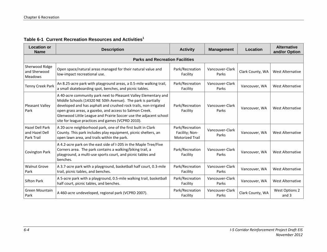
Table 6-1 Current Recreation Resources and Activities1
Location or Name
Description Activity Management Location Alternative
and/or Option
Parks and Recreation Facilities
Sherwood Ridge and Sherwood Meadows
Open space/natural areas managed for their natural value and low-impact recreational use.
Park/Recreation Facility
Vancouver-Clark Parks
Clark County, WA West Alternative
Tenny Creek Park An 8.25-acre park with playground areas, a 0.5-mile walking trail, a small skateboarding spot, benches, and picnic tables.
Park/Recreation Facility
Vancouver-Clark Parks
Vancouver, WA West Alternative
Pleasant Valley Park
A 40-acre community park next to Pleasant Valley Elementary and Middle Schools (14320 NE 50th Avenue). The park is partially developed and has asphalt and crushed rock trails, non-irrigated open grass areas, a gazebo, and access to Salmon Creek. Glenwood Little League and Prairie Soccer use the adjacent school site for league practices and games (VCPRD 2010).
Park/Recreation Facility
Vancouver-Clark Parks
Vancouver, WA West Alternative
Hazel Dell Park and Hazel Dell Park Trail
A 20-acre neighborhood park, one of the first built in Clark County. This park includes play equipment, picnic shelters, an open lawn area, and trails within the park.
Park/Recreation Facility; Non-
Motorized Trail
Vancouver-Clark Parks
Vancouver, WA West Alternative
Covington Park
A 4.2-acre park on the east side of I-205 in the Maple Tree/Five Corners area. The park contains a walking/biking trail, a playground, a multi-use sports court, and picnic tables and benches.
Park/Recreation Facility
Vancouver-Clark Parks
Vancouver, WA West Alternative
Walnut Grove Park
A 3.7-acre park with a playground, basketball half court, 0.3-mile trail, picnic tables, and benches.
Park/Recreation Facility
Vancouver-Clark Parks
Vancouver, WA West Alternative
Sifton Park A 5-acre park with a playground, 0.5-mile walking trail, basketball half court, picnic tables, and benches.
Park/Recreation Facility
Vancouver-Clark Parks
Vancouver, WA West Alternative
Green Mountain Park
A 460-acre undeveloped, regional park (VCPRD 2007). Park/Recreation
Facility Vancouver-Clark
Parks Clark County, WA
West Options 2 and 3

Chapter 6 Recreation
I-5 Corridor Reinforcement Project Draft EIS 6-5 November 2012
Location or Name
Description Activity Management Location Alternative
and/or Option
Green Meadows Golf Course
A private recreation facility that features golf, tennis, athletic, and social amenities. The golf course has programs and activities, and dining and entertainment areas.
Park/Recreation Facility
Private Vancouver, WA West Alternative
Camas Meadows Golf Club
A public recreation facility that includes an 18-hole golf course, driving range, and restaurant.
Park/Recreation Facility
Private Camas, WA West Options 1
and 3
Goot Park A park with an adult softball field, half basketball court, playground equipment, picnic areas, and restrooms.
Park/Recreation Facility
City of Camas Camas, WA West, Central, East, Crossover
Alternatives
Oak Park A 1.8-acre community park with a half basketball court, playground equipment, picnic tables, and a barbecue area.
Park/Recreation Facility
City of Camas Camas, WA West, Central, East, Crossover
Alternatives
Washougal River Greenway and Trail
The 86.7-acre greenway along the lower Washougal River provides shoreline access, picnic areas, fishing, and trails.
Park/Recreation Facility;
Non-Motorized Trails
City of Camas Clark County, WA West, Central, East, Crossover
Alternatives
Moulton Falls Park
A 387-acre regional park at the confluence of the East Fork Lewis River and Big Tree Creek with two waterfalls and an arch bridge more than 30 feet high. The Chelatchie Prairie Railroad excursion train also passes through the park. Areas of interest include volcanic rock formations from early lava flows, historic Indian meeting grounds, the Murphy Grade, a swing bridge on Big Tree Creek, and access to the Bells Mountain Trail.
Park/Recreation Facility
Vancouver-Clark Parks
Yacolt, WA Central Option 3
Riverside Park
A 58-acre community park along the Cowlitz River. The park has baseball and soccer fields, trails and walking pathways, playground equipment, picnic areas, basketball courts, and tennis courts. The park is used for picnicking, recreational activities for children from the Lexington area, and for fitness walking. It does not have access for fishing or launching boats.
Park/Recreation Facility;
Non-Motorized Trails
Cowlitz County Cowlitz County,
WA East Option 1

Chapter 6 Recreation
6-6 I-5 Corridor Reinforcement Project Draft EIS November 2012
Location or Name
Description Activity Management Location Alternative
and/or Option
Castle Rock High School
A 107-acre school park that includes the North County Recreation Sports Complex. The park has sports fields and facilities for school-related recreational activities.
Park/Recreation Facility
City of Castle Rock
Castle Rock, WA Central, East Alternatives
Sightseeing
Spirit Lake Memorial Highway
A 54-mile National Scenic Byway along SR 504. The highway begins in Castle Rock at Mt. St. Helens Way and ends on Johnston Ridge, with a view of the Mt. St. Helens crater.
Sightseeing WSDOT Cowlitz County,
WA Central, East Alternatives
Northern Clark County Scenic Drive
A 70-mile drive created by the Board of Clark County Commissioners. The drive goes through Battle Ground, Yacolt, La Center, and Ridgefield. Several parks are along the route, including Lucia Falls, Moulton Falls, Whipple Creek and Daybreak parks. Historic sites include the Henry Heisson House, the Cedar Creek Grist Mill, Allen House, and the Cathlapotle Plankhouse.
Sightseeing Clark County Clark County, WA West Alternative, Central Option 3
Lewis and Clark Trail Scenic Byway
The Lewis and Clark Trail Scenic Byway is 572 miles long in Washington and extends from Clarkston on the Idaho border to Cape Disappointment on the Pacific Coast. It is designated as a Washington State Scenic Byway. Washington SR 14, which would be crossed by the project, is part of this byway.
Sightseeing WSDOT Cowlitz and Clark
counties, WA
West, Central, East, Crossover
Alternatives
Columbia River Gorge Scenic Byway
The Columbia River Gorge Scenic Byway follows SR 14 for about 100 miles between Maryhill and Vancouver, Washington along the Columbia River. The scenic byway is designated as a Washington State Scenic Byway. All action alternatives cross SR 14. Scenic attractions near the project include Captain William Clark Park in Washougal, Washington. Lewis and Clark camped here for 6 days during their 1806 expedition.
Sightseeing WSDOT Clark County, WA West, Central, East, Crossover
Alternatives

Chapter 6 Recreation
I-5 Corridor Reinforcement Project Draft EIS 6-7 November 2012
Location or Name
Description Activity Management Location Alternative
and/or Option
Non-Motorized Trails
East Fork Lewis River Greenway
The greenway includes more than 1,000 acres of waterfront property along both banks of the East Fork Lewis River between Paradise Point State Park north of La Center and Daybreak Park north of Battle Ground. It is part of an interconnected, 10-mile greenway system. Most of the undeveloped greenway is open to non-motorized use.
Non-Motorized Trail
Vancouver-Clark Parks
Clark County, WA West Alternative
Castle Rock Riverfront Trail (East)
The trail is a 1.5-mile lighted, paved multi-use trail extending from Lion’s Pride Park north to just past the PH10 (A Street) bridge. Trail amenities include viewing areas, benches, and picnic tables.
Non-Motorized Trail
City of Castle Rock
Castle Rock, WA Central, East Alternatives
Ellen Davis Trail
A 2.5-mile crushed rock trail that connects Discovery Loop Trail at Leverich Park with St. James Road. The trailhead is at Leverich Park. The trail follows Burnt Bridge Creek through the BPA Ross Complex and the Minnehaha Neighborhood. It is a multi-use trail open to hikers and cyclists.
Non-Motorized Trail
Vancouver-Clark Parks
Vancouver, WA West Alternative
Washington State University Vancouver Campus Trail
Walking paths, jogging paths, and interpretive trails surrounding Washington State University's Vancouver Campus.
Non-Motorized Trail
Washington State University
Vancouver, WA West Alternative
Lacamas Heritage Trail
Lacamas Heritage Trail is a shared-use trail in East Clark County on the west side of Lacamas Lake and Lacamas Creek. It provides opportunities to view birds, rock formations, and waterfalls, and offers picnicking areas, extensive waterfront access, and a children’s play center. Clark County and the City of Camas own interconnected trail sections.
Non-Motorized Trail
Vancouver-Clark Parks
Camas, WA West Option 1

Chapter 6 Recreation
6-8 I-5 Corridor Reinforcement Project Draft EIS November 2012
Location or Name
Description Activity Management Location Alternative
and/or Option
Bells Mountain Trail
A primitive, 4-foot-wide shared-use trail serves hikers, mountain bikers, and equestrians. The trail can be accessed from Moulton Falls Park at the Hantwick Road Trailhead. The trail can also be accessed from the Cold Creek Day Use Area, which is operated by WDNR. Its highest point near the north end is about 1,500 feet. The trail passes through fir and alder forests with glimpses of Mt. St. Helens and Mt. Adams.
Non-Motorized Trail
Vancouver-Clark Parks
Clark County, WA Central
Alternative, East Option 2
Tarbell Trail (Larch Mountain Trail)
A 35-mile non-motorized loop trail system open to the public year-round. Parts of the trail have existed for more than 100 years and continue to be a popular destination trail system for non-motorized trail riders. Originally, the Tarbell trailhead, north of the forest, was used exclusively by equestrians and hikers; mountain bikers and other non-motorized recreationists also frequent the trailhead. The trail provides access to Larch Mountain and Cold Creek.
Non-Motorized Trail
WDNR Washougal WA East, Crossover
Alternatives
Lucia Falls/ Moulton Falls Trail
A primitive, shared-use trail that connects Moulton Falls and Lucia Falls parks. Points of interest include three waterfalls, volcanic rock formations from early lava flows, and an arch bridge over 30 feet high.
Non-Motorized Trail
Vancouver-Clark Parks
Yacolt, WA Central Option 3
40-Mile Loop Trail: Reynolds Trail
A 1.8-mile, paved non-motorized trail section on top of the levee in the Troutdale Reynolds Industrial Park. This trail is part of the 40-Mile Loop Trail system.
Non-Motorized Trail
40-Mile Loop Land Trust
Troutdale, OR West, Central, East, Crossover
Alternatives
40-Mile Loop Trail: Columbia River Trail Extension
A paved, non-motorized trail section connecting the Marine Drive portion of the 40-Mile Loop Trail and the Reynolds Trail. This section of the 40-Mile Loop Trail system is currently under construction.
Non-Motorized Trail
40-Mile Loop Land Trust
Troutdale, OR West, Central, East, Crossover
Alternatives
Chapter 6 Recreation
I-5 Corridor Reinforcement Project Draft EIS 6-9 November 2012
Location or Name
Description Activity Management Location Alternative
and/or Option
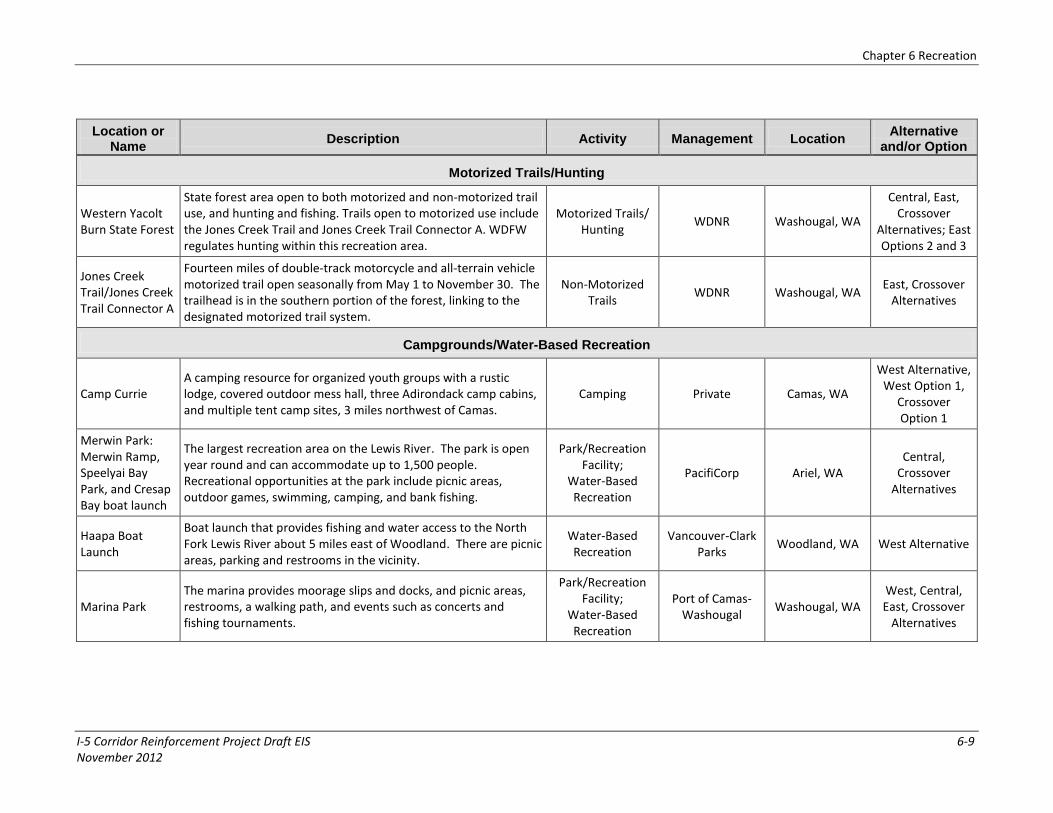
Motorized Trails/Hunting
Western Yacolt Burn State Forest
State forest area open to both motorized and non-motorized trail use, and hunting and fishing. Trails open to motorized use include the Jones Creek Trail and Jones Creek Trail Connector A. WDFW regulates hunting within this recreation area.
Motorized Trails/ Hunting
WDNR Washougal, WA
Central, East, Crossover
Alternatives; East Options 2 and 3
Jones Creek Trail/Jones Creek Trail Connector A
Fourteen miles of double-track motorcycle and all-terrain vehicle motorized trail open seasonally from May 1 to November 30. The trailhead is in the southern portion of the forest, linking to the designated motorized trail system.
Non-Motorized Trails
WDNR Washougal, WA East, Crossover
Alternatives
Campgrounds/Water-Based Recreation
Camp Currie A camping resource for organized youth groups with a rustic lodge, covered outdoor mess hall, three Adirondack camp cabins, and multiple tent camp sites, 3 miles northwest of Camas.
Camping Private Camas, WA
West Alternative, West Option 1,
Crossover Option 1
Merwin Park: Merwin Ramp, Speelyai Bay Park, and Cresap Bay boat launch
The largest recreation area on the Lewis River. The park is open year round and can accommodate up to 1,500 people. Recreational opportunities at the park include picnic areas, outdoor games, swimming, camping, and bank fishing.
Park/Recreation Facility;
Water-Based Recreation
PacifiCorp Ariel, WA Central,
Crossover Alternatives
Haapa Boat Launch
Boat launch that provides fishing and water access to the North Fork Lewis River about 5 miles east of Woodland. There are picnic areas, parking and restrooms in the vicinity.
Water-Based Recreation
Vancouver-Clark Parks
Woodland, WA West Alternative
Marina Park The marina provides moorage slips and docks, and picnic areas, restrooms, a walking path, and events such as concerts and fishing tournaments.
Park/Recreation Facility;
Water-Based Recreation
Port of Camas-Washougal
Washougal, WA West, Central, East, Crossover
Alternatives
Chapter 6 Recreation
6-10 I-5 Corridor Reinforcement Project Draft EIS November 2012
Location or Name
Description Activity Management Location Alternative
and/or Option
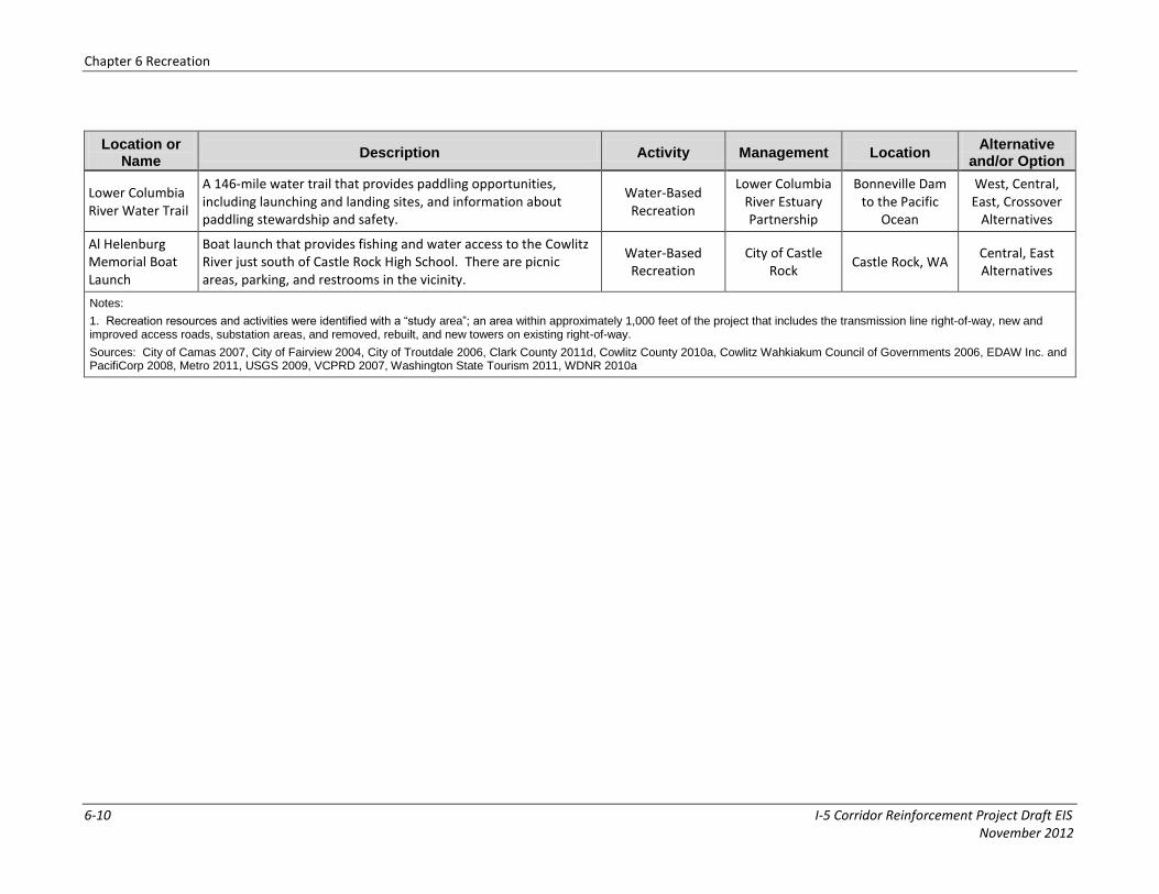
Lower Columbia River Water Trail
A 146-mile water trail that provides paddling opportunities, including launching and landing sites, and information about paddling stewardship and safety.
Water-Based Recreation
Lower Columbia River Estuary Partnership
Bonneville Dam to the Pacific
Ocean
West, Central, East, Crossover
Alternatives
Al Helenburg Memorial Boat Launch
Boat launch that provides fishing and water access to the Cowlitz River just south of Castle Rock High School. There are picnic areas, parking, and restrooms in the vicinity.
Water-Based Recreation
City of Castle Rock
Castle Rock, WA Central, East Alternatives
Notes:
1. Recreation resources and activities were identified with a “study area”; an area within approximately 1,000 feet of the project that includes the transmission line right-of-way, new and improved access roads, substation areas, and removed, rebuilt, and new towers on existing right-of-way.
Sources: City of Camas 2007, City of Fairview 2004, City of Troutdale 2006, Clark County 2011d, Cowlitz County 2010a, Cowlitz Wahkiakum Council of Governments 2006, EDAW Inc. and PacifiCorp 2008, Metro 2011, USGS 2009, VCPRD 2007, Washington State Tourism 2011, WDNR 2010a
Chapter 6 Recreation
I-5 Corridor Reinforcement Project Draft EIS 6-11 November 2012
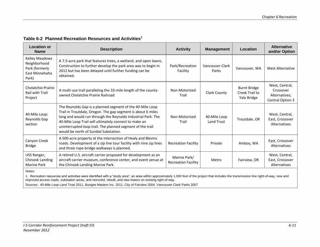
Table 6-2 Planned Recreation Resources and Activities1
Location or Name
Description Activity Management Location Alternative
and/or Option
Kelley Meadows Neighborhood Park (formerly East Minnehaha Park)
A 7.5-acre park that features trees, a wetland, and open lawns. Construction to further develop the park area was to begin in 2012 but has been delayed until further funding can be obtained.
Park/Recreation Facility
Vancouver-Clark Parks
Vancouver, WA West Alternative
Chelatchie Prairie Rail with Trail Project
A multi-use trail paralleling the 33-mile length of the county-owned Chelatchie Prairie Railroad
Non-Motorized Trail
Clark County Burnt Bridge Creek Trail to Yale Bridge
West, Central, Crossover
Alternatives; Central Option 3
40-Mile Loop: Reynolds Gap section
The Reynolds Gap is a planned segment of the 40-Mile Loop Trail in Troutdale, Oregon. The gap segment is about 6 miles long and would run through the Reynolds Industrial Park. The 40-Mile Loop Trail will ultimately connect to make an uninterrupted loop trail. The planned segment of the trail would be north of Sundial Substation.
Non-Motorized Trail
40-Mile Loop Land Trust
Troutdale, OR West, Central, East, Crossover
Alternatives
Canyon Creek Bridge
A 500-acre property at the intersection of Healy and Blevins roads. Development of a zip line tour facility with nine zip lines and three rope-bridge walkways is planned.
Recreation Facility Private Amboy, WA East, Crossover
Alternatives
USS Ranger, Chinook Landing Marine Park
A retired U.S. aircraft carrier proposed for development as an aircraft carrier museum, conference center, and event venue at the Chinook Landing Marine Park.
Marine Park/ Recreation Facility
Metro Fairview, OR West, Central, East, Crossover
Alternatives
Notes:
1. Recreation resources and activities were identified with a “study area”; an area within approximately 1,000 feet of the project that includes the transmission line right-of-way, new and improved access roads, substation areas, and removed, rebuilt, and new towers on existing right-of-way.
Sources: 40-Mile Loop Land Trust 2011, Bungee Masters Inc. 2011, City of Fairview 2004, Vancouver-Clark Parks 2007
Chapter 6 Recreation
I-5 Corridor Reinforcement Project Draft EIS 6-12 November 2012
6.1.4 Motorized Trails
Motorized trails are trails open for use by four-wheel drive vehicles, ATVs, and motorcycles that can also be used for non-motorized recreation (WDNR 2010a). In the study area, the only trails formally open for motorized recreation are in the Western Yacolt Burn State Forest; these trails include the Jones Creek Trail and Jones Creek Trail Connector A (see Table 6-1; Maps 6-1D, 6-1E). Longview Timberlands LLC, Sierra Pacific Industries, and Weyerhaeuser Company do not allow motorized recreational activities on their lands (WDNR 2010a), although unauthorized motorized uses could occur. WDNR reports that a lack of nearby areas for motorized recreation has driven this use to the Western Yacolt Burn State Forest, which has seen an increase in undesignated (unauthorized) motorized trail use (WDNR 2010a).
6.1.5 Hunting
Washington Department of Fish and Wildlife (WDFW) regulates hunting and issues hunting permits, both on private lands and on lands managed by the WDNR. The following are current hunting seasons in the project area:
Bear hunting from August to November
Deer and elk hunting from September to December
Elk hunting (rifle) season in the first half of November
Turkey hunting from April to May, September to October, and November to December
Pheasant hunting from September to October in Western Washington
Rabbit hunting from September to March
Grouse hunting from September to December (WDNR 2010a)
The Western Yacolt Burn State Forest is the largest WDNR-managed site in the study area open to hunting (see Table 6-1; Maps 6-1C, 6-1D, 6-1E). There are no other locations in Cowlitz or Clark counties where private landowners have entered into formal “Hunt by Written Permission” or “Feel Free to Hunt” agreements with WDFW to allow public access for hunting (WDFW 2009). Private landowners in the study area may have provided specific written permission to individual hunters, but none are registered with WDNR.
6.1.6 Campgrounds
Within the study area, opportunities for camping are limited. There is camping at Camp Currie (see Table 6-1; Maps 6-1D, 6-1E). Camping occurs in the Lewis River Recreation area (managed by PacifiCorp) at Cresap Bay Campground and in the Western Yacolt Burn Forest on WDNR land but these sites are outside the study area.
6.1.7 Water-Based Recreation
Water-based recreation in the study area includes fishing, boating, swimming, water skiing, jet skiing, kayaking, canoeing, parasailing, tubing, sailing, and rafting on lakes and rivers. There are more than 30 boat launch sites in southwest Washington for anglers, water skiers, jet skiers, and boaters. Public launches are available on the Cowlitz, Kalama, Lewis, and Columbia rivers, and
Chapter 6 Recreation
I-5 Corridor Reinforcement Project Draft EIS 6-13 November 2012
at Yale and Swift reservoirs (Cowlitz County Tourism Bureau 2010). The Columbia, Cowlitz, Kalama, Toutle and Lewis rivers have runs of salmon and steelhead. Yale and Merwin lakes provide opportunities to fish for crappie, bluegill, trout, kokanee, tiger muskies, and bass (Cowlitz County Tourism Bureau 2010). These water resources also provide opportunities for kayaking, canoeing, and boating. Boats can be launched at the Haapa Boat Launch, Washougal River Greenway Park, Merwin Park, the Port of Camas-Washougal Marina and the Chinook Landing Marine Park in the City of Fairview in Oregon (see Table 6-1; Maps 6-1C, 6-1D, 6-1E).
6.1.8 Dispersed Recreation
Dispersed recreation takes place outside of developed recreation facilities, and may include fishing, target shooting, hiking, nature appreciation, and backpacking (WDNR 2010a). Opportunities for authorized dispersed recreational uses exist within the study area on WDNR lands, including the Western Yacolt Burn State Forest area. Unauthorized recreation activities can also occur in these areas. Unauthorized recreational uses known to occur include target shooting, which occurs near the Casey Road substation site, and off-highway vehicle use.
6.2 Environmental Consequences
General impacts that would occur for the action alternatives are discussed below, followed by impacts unique to each alternative.
6.2.1 Impact Levels
Impacts would be high where project activities would cause the following:
Obstruct existing or planned dispersed recreational uses after project construction
Alter or eliminate dedicated recreation opportunities after project construction
Impacts would be moderate where project activities would cause the following:
Temporarily preclude or limit dispersed and dedicated recreational opportunities during peak use periods during project construction
Permanently impact user experience of a recreation resource
Create or encourage new unauthorized land uses along the right-of-way for recreational purposes, such as ATV use in unauthorized areas
Impacts would be low where project activities would cause the following:
Temporarily preclude or limit dispersed and dedicated recreational opportunities during off-peak use periods during project construction
Require relocation of dispersed recreational activities to an equal or better location after project construction
Temporarily impact user experience of a recreation resource
No impact would occur to recreation areas or activities if there would not be any effect on the location or quality of recreation facilities and uses during and after construction.

Chapter 6 Recreation
6-14 I-5 Corridor Reinforcement Project Draft EIS November 2012
6.2.2 Impacts Common to Action Alternatives
6.2.2.1 Construction
Both the Lewis and Clark Trail Scenic Byway and Columbia River Gorge Scenic Byway would be crossed at the same location on SR 14 by the action alternatives. Traffic could be slowed for brief periods during blasting near SR 14 (to protect cars from flying debris), or while the conductor is being strung across SR 14 by helicopter (see Chapter 12, Transportation). Temporary construction activity would create noise and dust, would increase traffic, and could delay access to sites or negatively change user experience at recreation sites. These would be low impacts because access to these scenic byways could be delayed but would not be limited or precluded, and because other impacts would be temporary.
The action alternatives would cross Oak Park in Camas, Washington and the Washougal River Greenway east of Camas in Clark County. During construction, access to these resources could be delayed or limited. Goot Park is just east of Segment 52 (common to all action alternatives) in Camas, and visitor experience of Goot Park could be affected by noise, dust, or visual intrusions. These impacts would be low if construction occurred during off-peak use periods, and moderate if conducted during peak use periods because impacts would be temporary and access would be limited. In addition, many parks in the surrounding area would be unaffected by the project and could provide additional recreation opportunities.
The Columbia River transmission line crossing would include in-water construction activities (see Chapter 3, Project Components). Temporary construction activities would introduce noise, dust, and visual intrusions from helicopters and barges into the scenic character at this crossing location, and could impact motorists’ experience along SR-14 scenic drives and the experience of fishermen or boaters along and on the river. Users most likely affected would be those seeking nature appreciation and wildlife viewing experiences; both could be negatively affected by construction noise and visual intrusions. However, impacts from construction would be low because construction would be temporary and would not restrict access to scenic drives or in-water areas.
Construction could also have a positive effect on the recreational experience of some users. Construction of a large project such as this one, which includes in-water construction and helicopters, could be a point of interest or even attract additional users to parks or other areas that provide views of construction activities.
6.2.2.2 Operation and Maintenance
The project would create impacts if tower, substation, or road placement changed a recreational function by limiting the use or removing facilities such as picnic areas, boat ramps, trails, or access areas. However, most impacts on recreation would be experiential in the form of intrusions to the aesthetic character of the area from helicopter inspections of the line that would occur twice each year. These intrusions would occur at specific recreation sites and at larger, informal recreational areas such as the Lewis and Clark Trail Scenic Byway, Columbia River Gorge Scenic Byway, and the Columbia River. The project would also be visible to users of distant recreation sites outside the study area.
The action alternatives would parallel existing transmission lines in some areas and would cross non-motorized trails a few times within the Washougal River Greenway (see Maps 6-1D

Chapter 6 Recreation
I-5 Corridor Reinforcement Project Draft EIS 6-15 November 2012
Impacts common to action alternatives are in Section 6.2.2. The remaining sections discuss impacts unique to each alternative, and recommended mitigation measures.
and 6-1E). The right-of-way for all action alternatives would bisect one 16-acre parcel of this park that contains the trails. The right-of-way would also run along the western edge of a 3.5-acre parcel of the park, and an improved access road (running east/west near Tower 52/8) would bisect the eastern portion of the parcel. About 0.3 acre of the park would be changed to towers and improved access roads. This would be a moderate impact because the project would follow existing transmission lines in some areas, would span the trails within the Washougal River Greenway, and there would be no towers within the 16-acre parcel split by the action alternatives. However, the presence of additional towers and conversion of a small portion of the park to tower footprints could affect the experience of visitors.
The action alternatives would be about 450 feet northwest of the Port of Camas-Washougal Marina (see Maps 6-1D and 6-1E). A new access road, located on the northwest corner of the property, would affect less than 0.1 acre of the marina (see Tables 6-3, 6-4, 6-5, and 6-6). This would be a low impact because the project would only convert a small corner of marina property into access roads, which would not affect user experience, and the transmission line would not span the marina or convert any of the Marina property to right-of-way or towers.
The action alternatives would remove and replace the existing two 230-kV transmission lines that cross the southern part of Oak Park with a new double-circuit 230-kV line. The new 500-kV line would parallel the replaced double-circuit line on the vacated right-of-way. Less than 0.1 acre of the park would be converted to new access roads (see Tables 6-3, 6-4, 6-5, and 6-6; Maps 6-1D and 6-1E). This would be a low impact because transmission lines already cross the park and the new line would be built within existing right-of-way. The new access road would affect the edge of the park, and this change to the park likely would not affect user experience.
New and improved access roads to and on right-of-way can provide increased access to forested areas of nearby parks and trails along the action alternatives. This could increase access for unauthorized hunting and ATV use on otherwise inaccessible lands causing a moderate impact to recreation areas. Signs and fencing may limit some potential impact.
6.2.2.3 Sundial Substation
There are no existing recreation resources within the Sundial site (see Map 6-1D) and no impacts on recreation from construction of the substation would occur. Part of the 40-Mile Loop Trail, called the Reynolds Gap, is planned to be constructed north of the site on top of the levee with a full view of the industrial complex. There is no schedule at this time to begin construction. The substation, new roads, and transmission lines would not be out of context with the existing industrial nature of the area. In addition, project components would not interfere with the levee or the future trail.
6.2.3 Castle Rock Substation Sites
There are no existing recreation resources within the Casey Road, Baxter Road, or Monahan Creek sites, so there would be no impacts at these sites (see Map 6-1A). There is known unauthorized dispersed recreation in the area of the Casey Road substation site; however, because this use is unauthorized, any changes to the availability of this use from construction of the substation would be a low impact.

Chapter 6 Recreation
6-16 I-5 Corridor Reinforcement Project Draft EIS November 2012
6.2.4 West Alternative
6.2.4.1 Construction
During construction, about 5 acres of recreation facilities and less than 0.1 mile of trails would be temporarily disturbed. The disturbed area would include less than 0.1 acre of the East Fork Lewis River Greenway, almost 2 acres of the Green Meadows Golf Course, almost 3 acres of Camp Currie, and less than 1 acre of the Washougal River Greenway (see Maps 6-1A, 6-1C, 6-1D). Temporarily disturbed trails would include about 50 feet of the Ellen Davis Trail and 200 feet of the Washington State University Vancouver Campus Trail (see Map 6-1D). Temporary disturbance could include noise, dust, restricted access, and visual disturbances.
Construction would occur throughout the year. Summer months are peak use time for general recreation; peak use times for hunting vary by type of hunting (see Section 6.1.5, Hunting). The winter months are non-peak use times for all recreational uses. During peak use times, the West Alternative’s temporary impacts on recreation resources would be moderate. During non-peak times, temporary impacts on these recreation resources would be low. Any temporary impacts on user experience from construction would be low. In addition, many parks in the surrounding area would be unaffected by the project and could provide additional recreation opportunities.
The West Alternative route would be near the Haapa Boat Launch; Pleasant Valley, Covington, Sifton, Goot, Tenny Creek, and Walnut Grove parks; Hazel Dell Park and Hazel Dell Park Trail; and Sherwood Ridge and Sherwood Meadows (see Tables 6-1, 6-2; Maps 6-1C, 6-1D, 6-1E). Construction activities could occasionally and temporarily disturb the quiet and scenic landscape at these recreation resources, but these resources would still be accessible. Because no project components would be within these resources and construction activities would be temporary, there would be no-to-low impact on these resources.
6.2.4.2 Operation and Maintenance
Required project facilities for the West Alternative would permanently occupy about 8.9 acres of recreation land. Of this total, 0.9 acre would be affected by towers, about 5.5 acres would be affected by new access roads, and about 2.5 acres would be affected by access road improvements (see Table 6-3). In addition, less than 0.3 miles of trails would be permanently crossed by new or improved access roads (see Table 6-3).
The West Alternative would follow existing right-of-way along the eastern edge of the East Fork Lewis River Greenway (see Map 6-1C). New access roads would affect about 3 acres within the greenway (see Table 6-3). No towers or improved access roads would be within the greenway. The new access roads and the transmission line would add an industrial, human-made element to the greenway and would have experiential impacts on recreationists (see Chapter 7, Visual Resources). The new roads would affect areas within the park that are managed for protection and enhancement of the natural environment. This would cause a high impact because it would permanently alter a dedicated recreation resource.

Chapter 6 Recreation
6-17 I-5 Corridor Reinforcement Project Draft EIS November 2012
Table 6-3 West Alternative and Options—Permanent Impacts on Parks and Trails
Alternative and Options
1,2
Recreation Resource
Towers3 New Access Roads
4 Improved Access Roads
4
West Alternative
Parks (acres)
Camp Currie (0.6), Green Meadows Golf Course (0.2), Washougal River Greenway (0.1)
Camp Currie (1.2),
East Fork Lewis River Greenway (3.1),
Green Meadows Golf Course (0.8), Port of Camas-Washougal Marina (<0.1),
Oak Park (<0.1)
Camp Currie (0.3), Green Meadows Golf Course (1.9), Washougal River Greenway (0.2)
Trails (miles) -- Ellen Davis Trail (<0.1), Washington State University Vancouver Campus Trail (<0.1)
Washington State University Vancouver Campus Trail (<0.1)
West Option 1 Parks (acres)
Camas Meadows Golf Club (+0.2), Camp Currie (-0.2), Green Meadows Golf Course (-0.2)
Camas Meadows Golf Club (+0.1),
Camp Currie (+0.5), Green Meadows Golf Course (-0.8)
Camp Currie (-0.3), Green Meadows Golf Course (-1.9), Camas Meadows Golf Club (+0.2)
Trails (miles) Lacamas Heritage Trail (+0.1) Lacamas Heritage Trail (+0.3) Lacamas Heritage Trail (+<0.1)
West Option 2 Parks (acres)
Green Mountain (+0.5),
Camp Currie (-0.6), Green Meadows Golf Course (-0.2)
Green Mountain (+2.3), Camp Currie (-1.2), Green Meadows Golf Course (-0.8)
Green Mountain (+2.4),
Camp Currie (-0.3), Green Meadows Golf Course (-1.9)
Trails (miles) N/C N/C N/C
West Option 3 Parks (acres)
Green Mountain (+0.5),
Camp Currie (-0.6), Green Meadows Golf Course (-0.2)
Green Mountain (+0.9), Camp Currie (-1.2), Green Meadows Golf Course (-0.8)
Green Mountain (+2.4),
Camp Currie (-0.3), Green Meadows Golf Course (-1.9)
Trails (miles) N/C N/C N/C
Notes:
N/C – No net change from the action alternative.
1. The value for each option represents the net change from the action alternative. It was calculated as the total impacted acres or miles added by the option minus the total impacted acres or miles in the segments the option replaces.
2. No permanent impacts would occur in substation areas.
3. Includes rebuilt and new towers.
4. Includes access roads within and outside of the 150-foot right-of-way.
Sources: Clark County 2011d, Cowlitz Wahkiakum Council of Governments 2006, Metro 2011, USGS, 2009
Chapter 6 Recreation
I-5 Corridor Reinforcement Project Draft EIS 6-18 November 2012
The West Alternative would cross the Northern Clark County Scenic Drive at Northeast Cedar Creek Road and at Northeast 259th Street (see Map 6-1C). The transmission route would be on existing right-of-way and parallel an existing line that already crosses the scenic drive. The additional visual intrusion from the new line would be minor and a motorists view of the crossing would be temporary, a low impact.
The existing right-of-way is on the eastern side of the Washington State University Vancouver Campus and crosses the Campus Trail multiple times (see Maps 6-1D and 6-1E). An improved access road would also follow part of the trail for over 300 feet. Less than 0.1 mile of the trail would be changed to new and improved access roads (see Table 6-3). Though the West Alternative would follow existing right-of-way and no towers would be in the trail, this would be a high impact because a small area (less than 0.1 mile) of the trail would be changed to new access roads. This would permanently alter this dedicated recreation resource.
A small area of the Ellen Davis Trail would also be affected. The West Alternative would pass near this trail along the trail’s north side. Less than 0.1 mile of the trail would be permanently changed to new access road where it would cross the trail near its eastern end. Although this is a small portion of the Ellen Davis Trail, the impact to this area would be high because it would permanently alter the recreation resource.
The West Alternative would cross the northern part of Kelley Meadows Neighborhood Park (formerly East Minnehaha Park) (see Maps 6-1D and 6-1E). No new towers, new access roads, or improved access roads would be within the park area. This 7.5-acre park is currently undeveloped and primarily consists of open lawn areas. Construction to develop the park area was scheduled to begin in 2012 but do to the continuing depressed economy construction has been delayed until further funds can be obtained (see Table 6-2). The final layout of the park is being developed, and this project could influence the final park design to avoid placing developed areas of the park within the right-of-way. This would be a no-to-low impact because there would be no towers or roads placed in the park area, the park does not currently contain large numbers of trees that would be removed, and the park layout is still being developed and could be coordinated with BPA.
The West Alternative would diagonally bisect the Green Meadows Golf Course, paralleling an existing transmission line through the golf course (see Maps 6-1D and 6-1E). Almost 3 acres of the golf course would be changed to towers, new access roads, and improved access roads (see Table 6-3). This would be a moderate impact because an existing transmission line bisects the golf course, and already affects the recreational experience of golfers. The West Alternative would follow the northeast boundary of Camp Currie (a portion of which is in existing right-of-way) (see Maps 6-1D and 6-1E). About 2 acres of the camp would be changed to towers, new access roads, and improved access roads (see Table 6-3). This would cause a moderate impact because the existing right-of-way is near the edge of the camp property and only separates about 5 acres of the northeast corner of the property from the rest of the camp.
The West Alternative route would be near the Haapa Boat Launch; Pleasant Valley, Covington, Sifton, Goot, Tenny Creek, and Walnut Grove parks; Hazel Dell Park and Hazel Dell Park Trail; and Sherwood Ridge and Sherwood Meadows (see Tables 6-1, 6-2; Maps 6-1C, 6-1D, 6-1E). The transmission line could visually intrude on the recreational experience of the park and trail users, but there are existing transmission lines that presently pass by these recreation areas and a new line would not be inconsistent with existing views. No towers or right-of-way would be within the parks, so there would be no-to-low impact on these resources.

Chapter 6 Recreation
I-5 Corridor Reinforcement Project Draft EIS 6-19 November 2012
6.2.4.3 West Option 1
West Option 1 would replace a portion of the alternative that follows existing right-of-way just east of Vancouver with an option that is farther west and closer to Vancouver. Tower construction would temporarily disturb an additional 0.5 acre of parks, about 1.7 acres of the Camas Meadows Golf Club, and 0.8 acre of the Lacamas Heritage Trail. About 0.2 acre of Camp Currie and 1.7 acres of Green Meadows Golf Course would be unaffected (see Table 6-3 and Maps 6-1D and 6-1E). Temporary disturbance could include dust and noise, limited access, visual disturbance, or impacts on user experience. During peak use times (summer months and hunting season), construction of West Option 1 would cause temporary moderate impacts on the golf club, Camp Currie, and the Lacamas Heritage Trail, and low impacts during non-peak times. Any temporary impacts on user experience at these locations would be low.
West Option 1 would reduce the area permanently affected by towers by about 0.2 acre, and reduce the additional area of parks that would be affected by new and improved access roads by almost 2 acres (see Table 6-3). West Option 1’s right-of-way would cross the northern part of Camas Meadows Golf Club instead of the Green Meadows Golf Course and follow the existing right-of-way east-west through Camp Currie instead of the eastern border of the camp (see Map 6-1D). West Option 1 would also add the Lacamas Heritage Trail to those crossed by improved access roads (see Table 6-3). No towers would be constructed within the trail, and the portion of the line crossing the trail would follow existing right-of-way. West Option 1 would reduce the total area of parks and increase the amount of trails that would be changed to towers and access roads. This option could create moderate permanent impacts on user experiences at the golf club, and Camp Currie.
6.2.4.4 West Option 2
West Option 2 would replace a portion of the alternative in the rural residential areas north of Camas with an option farther to the east in the same area. West Option 2 would reduce the temporary disturbance from tower construction by almost 2 acres. West Option 2 would increase the amount of land permanently converted to towers and access roads by about 5 acres within Green Mountain Park, but would eliminate permanent impacts within Camp Currie and Green Meadows Golf Course (see Table 6-3 and Map 6-1D). Impacts on Green Mountain Park would be low because the park is not heavily used and the option would follow existing right-of-way for most of its length.
6.2.4.5 West Option 3
West Option 3 would replace a portion of the West Alternative in the rural residential areas north of Camas with a route crossing rural residential and rural areas farther east. West Option 3 would reduce the temporary disturbance to parks from tower construction by almost 2 acres. This option would permanently impact about 4 acres of land within Green Mountain Park, but would not impact Camp Currie or
Chapter 6 Recreation
6-20 I-5 Corridor Reinforcement Project Draft EIS November 2012
Green Meadows Golf Course. Impacts on Green Mountain Park would remain low because the park is not heavily used and the option would follow existing right-of-way for most of its length.
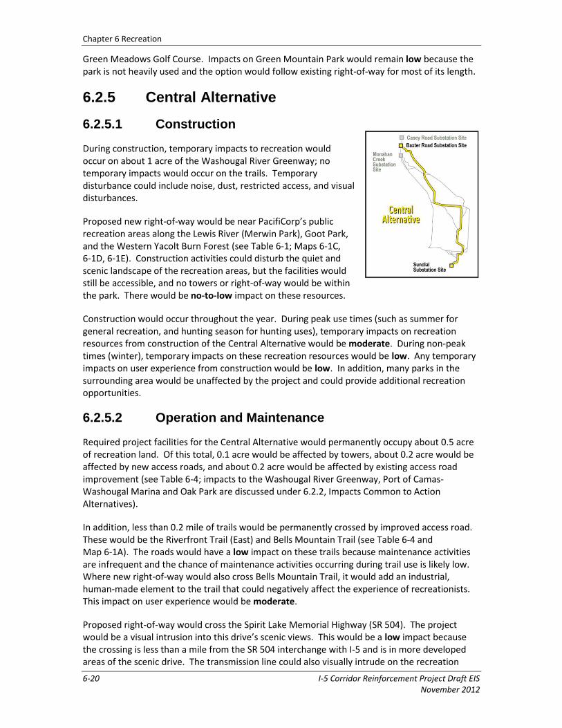
6.2.5 Central Alternative
6.2.5.1 Construction
During construction, temporary impacts to recreation would occur on about 1 acre of the Washougal River Greenway; no temporary impacts would occur on the trails. Temporary disturbance could include noise, dust, restricted access, and visual disturbances.
Proposed new right-of-way would be near PacifiCorp’s public recreation areas along the Lewis River (Merwin Park), Goot Park, and the Western Yacolt Burn Forest (see Table 6-1; Maps 6-1C, 6-1D, 6-1E). Construction activities could disturb the quiet and scenic landscape of the recreation areas, but the facilities would still be accessible, and no towers or right-of-way would be within the park. There would be no-to-low impact on these resources.
Construction would occur throughout the year. During peak use times (such as summer for general recreation, and hunting season for hunting uses), temporary impacts on recreation resources from construction of the Central Alternative would be moderate. During non-peak times (winter), temporary impacts on these recreation resources would be low. Any temporary impacts on user experience from construction would be low. In addition, many parks in the surrounding area would be unaffected by the project and could provide additional recreation opportunities.
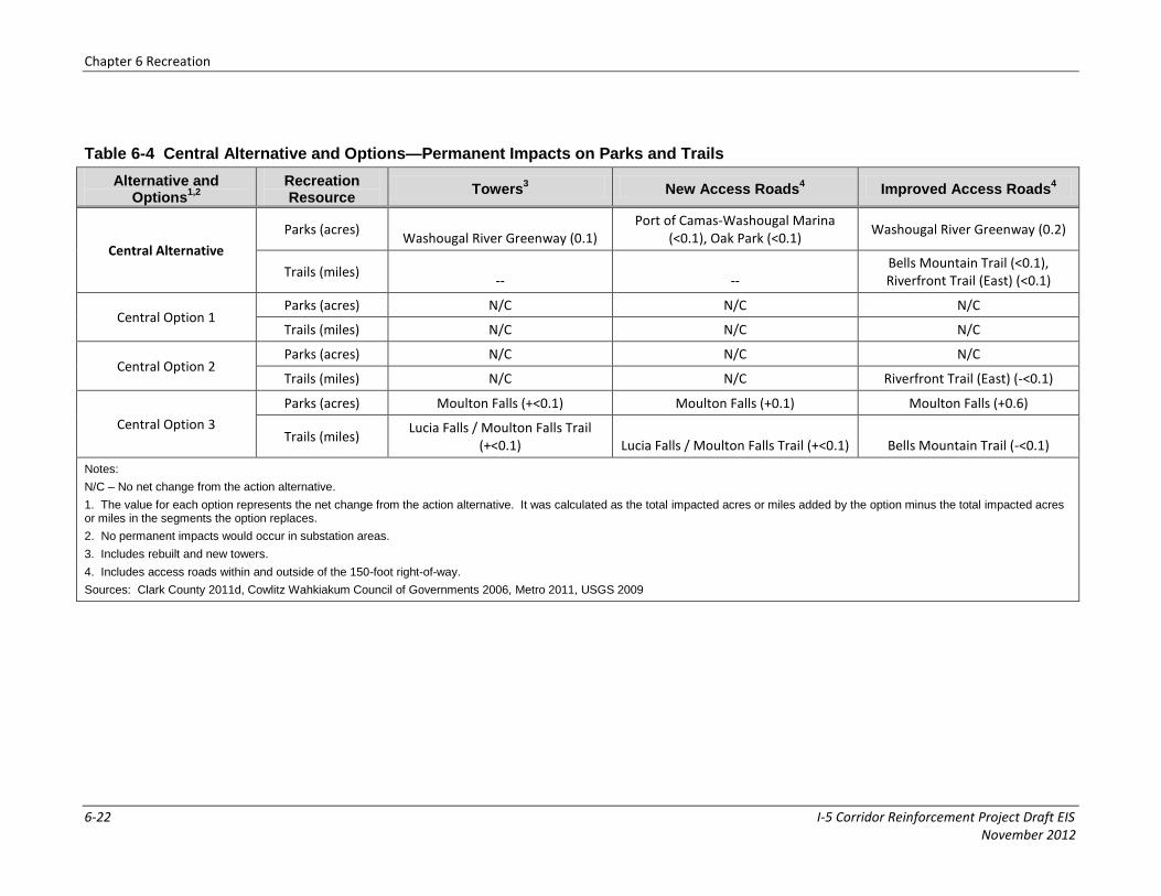
6.2.5.2 Operation and Maintenance
Required project facilities for the Central Alternative would permanently occupy about 0.5 acre of recreation land. Of this total, 0.1 acre would be affected by towers, about 0.2 acre would be affected by new access roads, and about 0.2 acre would be affected by existing access road improvement (see Table 6-4; impacts to the Washougal River Greenway, Port of Camas-Washougal Marina and Oak Park are discussed under 6.2.2, Impacts Common to Action Alternatives).
In addition, less than 0.2 mile of trails would be permanently crossed by improved access road. These would be the Riverfront Trail (East) and Bells Mountain Trail (see Table 6-4 and Map 6-1A). The roads would have a low impact on these trails because maintenance activities are infrequent and the chance of maintenance activities occurring during trail use is likely low. Where new right-of-way would also cross Bells Mountain Trail, it would add an industrial, human-made element to the trail that could negatively affect the experience of recreationists. This impact on user experience would be moderate.
Proposed right-of-way would cross the Spirit Lake Memorial Highway (SR 504). The project would be a visual intrusion into this drive’s scenic views. This would be a low impact because the crossing is less than a mile from the SR 504 interchange with I-5 and is in more developed areas of the scenic drive. The transmission line could also visually intrude on the recreation

Chapter 6 Recreation
I-5 Corridor Reinforcement Project Draft EIS 6-21 November 2012
experience of park and trail users where it is visible from Merwin Park, Goot Park, and the Western Yacolt Burn Forest. However, no towers or right-of-way would be within these parks, so no-to-low impacts on these resources would occur.
6.2.5.3 Central Options 1 and 2
Central Option 1 would begin at the Casey Road substation site and the transmission line would cross unpopulated forest production and open space land. Central Option 2 would begin at the Monahan Creek substation site and would remove the portion of the Central Alternative crossing the Cowlitz River north of Castle Rock and running farther to the southeast. This option would add a new route running southeast from the Monahan Creek substation site through sparsely populated land, crossing the unincorporated community of West Side Highway next to SR 411, the Cowlitz River and I-5, and running through largely unpopulated land toward the east.
Central Options 1 and 2 would have no additional impacts since there are no parks or trails along these options. In addition, there would be no impact on the Riverfront Trail (East) from access road improvements under Central Option 2 because it would not cross the trail. There would be no impact on the Spirit Lake Memorial Highway at SR 504 from visual intrusions by either option (see Table 6-4 and Map 6-1A) because they do not cross the highway. Unauthorized target shooting at the Casey Road substation site is discussed in Section 6.2.3, Castle Rock Substation Sites.
6.2.5.4 Central Option 3
Central Option 3 would replace the Lewis River crossing near Ariel and a portion of the Central Alternative between Ariel and Venersborg, with a downstream river crossing and a new route running directly southeast from Ariel through rural residential areas toward Venersborg. Central Option 3 would have no impact on Bells Mountain Trail or the recreation resources within the Western Yacolt Burn Forest because this option does not cross these resources. This option does not directly cross the recreation resources near PacifiCorp’s public recreation areas along the Lewis River (Merwin Park), but construction activities could disturb the quiet and scenic landscape of the recreation area. Because facilities would still be accessible, and no towers or right-of-way would be within the park, there would be no-to-low impact on these resources.
Tower construction for Central Option 3 would temporarily disturb about 0.2 acre of Moulton Falls Park. Less than 0.1 acre of the park would be permanently changed by towers, and an additional 0.7 acre would be changed by new and improved access roads. Tower construction would temporarily disturb less than 0.1 mile of the Lucia Falls/Moulton Falls Trail (a wide paved trail); towers would permanently alter less than 0.1 mile of trail, and less than 0.1 mile of the trail would be converted to a new access road.
Chapter 6 Recreation
6-22 I-5 Corridor Reinforcement Project Draft EIS November 2012
Table 6-4 Central Alternative and Options—Permanent Impacts on Parks and Trails
Alternative and Options
1,2
Recreation Resource
Towers3 New Access Roads
4 Improved Access Roads
4
Central Alternative
Parks (acres) Washougal River Greenway (0.1)
Port of Camas-Washougal Marina (<0.1), Oak Park (<0.1)
Washougal River Greenway (0.2)
Trails (miles) -- --
Bells Mountain Trail (<0.1), Riverfront Trail (East) (<0.1)
Central Option 1 Parks (acres) N/C N/C N/C
Trails (miles) N/C N/C N/C
Central Option 2 Parks (acres) N/C N/C N/C
Trails (miles) N/C N/C Riverfront Trail (East) (-<0.1)
Central Option 3
Parks (acres) Moulton Falls (+<0.1) Moulton Falls (+0.1) Moulton Falls (+0.6)
Trails (miles) Lucia Falls / Moulton Falls Trail
(+<0.1) Lucia Falls / Moulton Falls Trail (+<0.1) Bells Mountain Trail (-<0.1)
Notes:
N/C – No net change from the action alternative.
1. The value for each option represents the net change from the action alternative. It was calculated as the total impacted acres or miles added by the option minus the total impacted acres or miles in the segments the option replaces.
2. No permanent impacts would occur in substation areas.
3. Includes rebuilt and new towers.
4. Includes access roads within and outside of the 150-foot right-of-way.
Sources: Clark County 2011d, Cowlitz Wahkiakum Council of Governments 2006, Metro 2011, USGS 2009

Chapter 6 Recreation
I-5 Corridor Reinforcement Project Draft EIS 6-23 November 2012
The route and access roads would require vegetation clearing for new right-of-way through the park. The project would visually intrude on the recreational experience of visitors to the park and trail. Impacts could be mitigated by repositioning the access road and tower away from the trail and minimizing vegetation removal near the trail as much as possible. A high impact would occur at Lucia Falls/Moulton Falls Trail because this recreation resource would be permanently altered.
Central Option 3 would also cross the Northern Clark County Scenic Drive at Northeast Cedar Creek Road and at Lucia Falls Road (see Table 6-4 and Map 6-1C). The project would be a visual intrusion into the drive’s scenic views because, unlike the West Alternative, there is no existing right-of-way at these crossings. While motorist’s views of cleared vegetation would be temporary and the transmission line would be high above the windshield view, the character of the drive at these locations would be different and permanent, a moderate impact.
6.2.6 East Alternative
6.2.6.1 Construction
Tower construction would temporarily disturb about 0.7 acre of the Washougal River Greenway and about 0.1 mile of the Tarbell Trail. Access to the Riverfront Trail (East) and the Jones Creek Trail might also be limited during construction where roads crossing the trails would be improved.
Construction would occur throughout the year, weather permitting. During peak use times (such as summer for general recreation, hunting season for hunting uses), temporary impacts on recreation resources would be moderate. During non-peak times (such as winter), temporary impacts on these resources would be low. Any temporary impacts on user experience from construction would be low. In addition, many parks in the surrounding area would be unaffected by the project and could provide additional recreation opportunities.
Similar to the Central Alternative, the East Alternative right-of-way would be near PacifiCorp’s public recreation areas between Lake Merwin and Yale Lake, Goot Park, Larch Mountain Trail, and within the Western Yacolt Burn Forest (see Table 6-1; Maps 6-1C and 6-1D). Construction activities could disturb the quiet and scenic landscape of these recreation areas, but the facilities would still be accessible. No towers or right-of-way would be within these recreation areas, so no-to-low impacts on these resources would occur.
6.2.6.2 Operation and Maintenance
Required project facilities for the East Alternative would permanently occupy about 0.5 acre of recreation land. Of this total, 0.1 acre would be affected by towers, about 0.2 acre would be affected by new access roads, and 0.2 acre would be affected by improvement of existing access roads (see Table 6-5; impacts on the Washougal River Greenway, Port of Camas-Washougal Marina and Oak Park are discussed under 6.2.2, Impacts Common to Action Alternatives).
In addition, less than 0.6 mile of trails would be permanently crossed by towers, and new and improved access roads. Less than 0.1 mile of the Riverfront Trail would be converted to

Chapter 6 Recreation
6-24 I-5 Corridor Reinforcement Project Draft EIS November 2012
improved access road. Less than 0.1 mile of the Tarbell Trail would be converted to towers, and less than 0.5 mile of additional trail would be converted to new and improved access roads (see Table 6-5 and Maps 6-1C, 6-1D, 6-1E), a high impact since the trail would be permanently altered by the project. Impacts to the trail might be mitigated by adjusting locations of towers and roads or by moving portions of the trail. The impact on user experience would be moderate since the project would add an industrial, human-made element to views from the trail that could negatively affect the experience of recreationists.
Improved access roads would upgrade about 0.2 mile of the Jones Creek Trail (see Table 6-5; Maps 6-1D and 6-1E). This is a motorized trail, so the upgrades would add traffic to the trail and potentially improve the trail experience for ATV users by changing the road conditions (e.g., surface, width). The right-of-way would be west of the trail and could add an industrial, human-made element to the views from the trail that could negatively affect the experience of recreationists. The impact on user experience would be moderate.
The right-of-way for the East Alternative would cross the Tarbell Trail eight times, going through the middle of the trail’s loop (see Map 6-1C). At the northern portion of the trail, five crossings would occur and the right-of-way would closely parallel the trail for about 1 mile. At the southern portion of the trail, three crossings would occur and the right-of-way would closely parallel the trail for about 1,500 feet. Less than 0.1 mile of the trail would be changed to towers and an additional 0.1 mile of the trail would be converted to new and improved access roads. The right-of-way, towers, and access roads would add an industrial, human-made element to the trail’s views that could negatively impact the experience of recreationists. The access roads would also convert portions of a non-motorized trail to motorized uses, which may require moving parts of the trail. Because permanent alterations to the trail would be necessary, this would be a moderate-to-high impact. Visual and experiential impacts to the recreational user could be eliminated by relocating nearby sections of the trail away from the right-of-way.
Like the Central Alternative, the right-of-way would cross the Spirit Lake Memorial Highway (SR 504) and be a visual intrusion into the drives scenic views (see Section 6.2.5.2, Operation and Maintenance). This would be a low impact because the crossing is less than 1 mile from the SR 504 interchange with I-5 and is in more developed areas of the scenic drive. The transmission line could also visually intrude on the recreation experience at PacifiCorp’s public recreation areas between Lake Merwin and Yale Lake, Goot Park, Larch Mountain Trail, and the Western Yacolt Burn Forest. However, no towers or right-of-way would be in these areas, so no-to-low impacts on these resources would occur. The Silver Star trailhead and trail system are inside the Silver Star Scenic Area of the Gifford Pinchot National Forest but outside the study area. The Silver Star trail climbs to the peak of Silver Star Mountain, about 2 miles east of the East Alternative. From the peak, the East Alternative would be visible to hikers and would visually intrude on scenic views of the area west of the peak. Because this could negatively impact user experiences, it would be a moderate impact.

Chapter 6 Recreation
6-25 I-5 Corridor Reinforcement Project Draft EIS November 2012
Table 6-5 East Alternative and Options—Permanent Impacts on Parks and Trails
Alternative and Options
1,2
Recreation Resource
Towers3 New Access Roads
4 Improved Access Roads
4
East Alternative
Parks (acres) Washougal River Greenway (0.1)
Port of Camas-Washougal Marina (<0.1), Oak Park (<0.1) Washougal River Greenway (0.2)
Trails (miles) Tarbell Trail (<0.1) Tarbell Trail (0.1)
Jones Creek Trail (0.2), Riverfront Trail (East) (<0.1), Tarbell Trail (<0.1)
East Option 1 Parks (acres) N/C N/C N/C
Trails (miles) N/C N/C Riverfront Trail (East) (-<0.1)
East Option 2
Parks (acres) N/C N/C N/C
Trails (miles) Tarbell Trail
(-<0.1) Tarbell Trail
(-0.1) Bells Mountain Trail (+<0.1), Jones
Creek Trail (-0.2), Tarbell Trail (-<0.1)
East Option 3
Parks (acres) N/C N/C N/C
Trails (miles) Jones Creek Trail (+<0.1)
Jones Creek Trail Connector A (+<0.1)
Jones Creek Trail Connector A (+0.3), Jones Creek Trail (-0.2)
Notes:
N/C – No net change from the action alternative.
1. The value for each option represents the net change from the action alternative. It was calculated as the total impacted acres or miles added by the option minus the total impacted acres or miles in the segments the option replaces.
2. No permanent impacts would occur in substation areas.
3. Includes rebuilt and new towers.
4. Includes access roads within and outside of the 150-foot right-of-way.
Sources: Clark County 2011d, Cowlitz Wahkiakum Council of Governments 2006, Metro 2011, USGS 2009
Chapter 6 Recreation
I-5 Corridor Reinforcement Project Draft EIS 6-26 November 2012
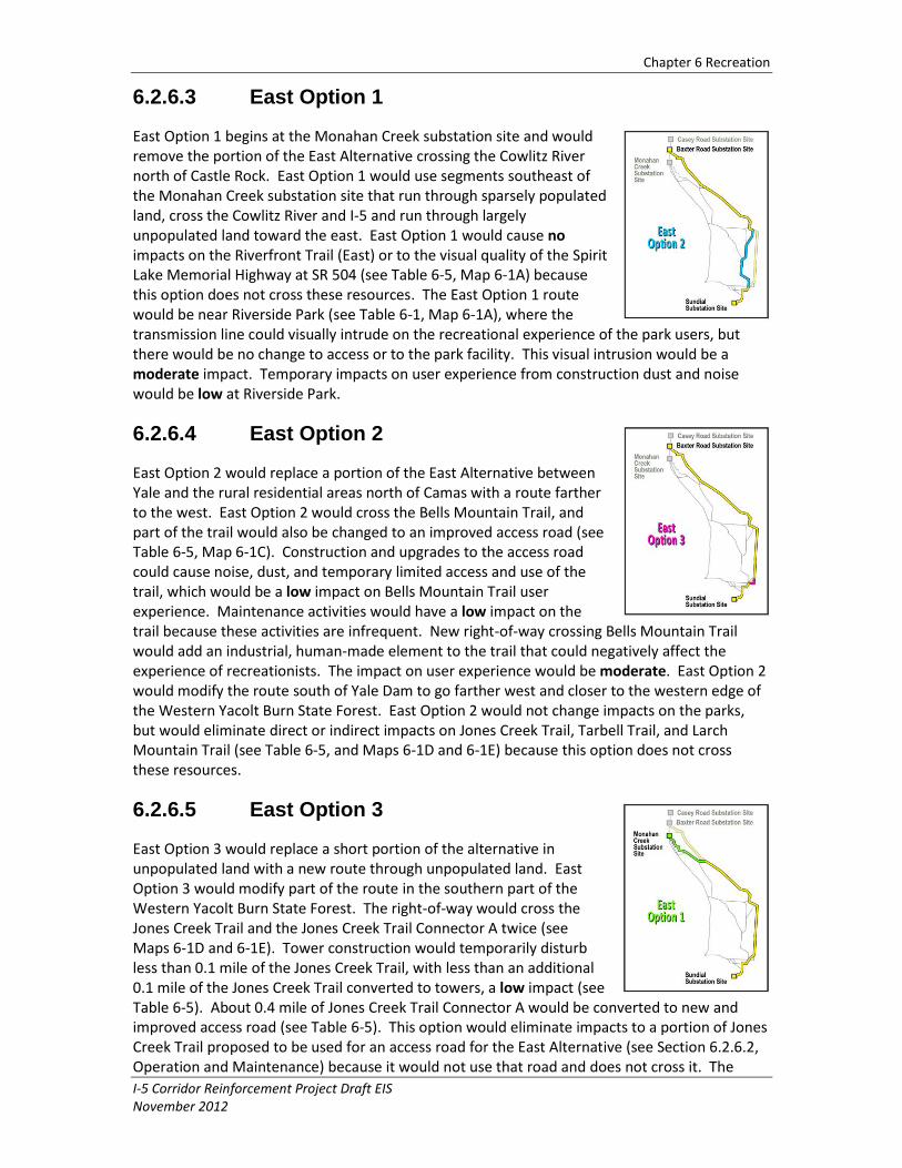
6.2.6.3 East Option 1
East Option 1 begins at the Monahan Creek substation site and would remove the portion of the East Alternative crossing the Cowlitz River north of Castle Rock. East Option 1 would use segments southeast of the Monahan Creek substation site that run through sparsely populated land, cross the Cowlitz River and I-5 and run through largely unpopulated land toward the east. East Option 1 would cause no impacts on the Riverfront Trail (East) or to the visual quality of the Spirit Lake Memorial Highway at SR 504 (see Table 6-5, Map 6-1A) because this option does not cross these resources. The East Option 1 route would be near Riverside Park (see Table 6-1, Map 6-1A), where the transmission line could visually intrude on the recreational experience of the park users, but there would be no change to access or to the park facility. This visual intrusion would be a moderate impact. Temporary impacts on user experience from construction dust and noise would be low at Riverside Park.
6.2.6.4 East Option 2
East Option 2 would replace a portion of the East Alternative between Yale and the rural residential areas north of Camas with a route farther to the west. East Option 2 would cross the Bells Mountain Trail, and part of the trail would also be changed to an improved access road (see Table 6-5, Map 6-1C). Construction and upgrades to the access road could cause noise, dust, and temporary limited access and use of the trail, which would be a low impact on Bells Mountain Trail user experience. Maintenance activities would have a low impact on the trail because these activities are infrequent. New right-of-way crossing Bells Mountain Trail would add an industrial, human-made element to the trail that could negatively affect the experience of recreationists. The impact on user experience would be moderate. East Option 2 would modify the route south of Yale Dam to go farther west and closer to the western edge of the Western Yacolt Burn State Forest. East Option 2 would not change impacts on the parks, but would eliminate direct or indirect impacts on Jones Creek Trail, Tarbell Trail, and Larch Mountain Trail (see Table 6-5, and Maps 6-1D and 6-1E) because this option does not cross these resources.
6.2.6.5 East Option 3
East Option 3 would replace a short portion of the alternative in unpopulated land with a new route through unpopulated land. East Option 3 would modify part of the route in the southern part of the Western Yacolt Burn State Forest. The right-of-way would cross the Jones Creek Trail and the Jones Creek Trail Connector A twice (see Maps 6-1D and 6-1E). Tower construction would temporarily disturb less than 0.1 mile of the Jones Creek Trail, with less than an additional 0.1 mile of the Jones Creek Trail converted to towers, a low impact (see Table 6-5). About 0.4 mile of Jones Creek Trail Connector A would be converted to new and improved access road (see Table 6-5). This option would eliminate impacts to a portion of Jones Creek Trail proposed to be used for an access road for the East Alternative (see Section 6.2.6.2, Operation and Maintenance) because it would not use that road and does not cross it. The
Chapter 6 Recreation
I-5 Corridor Reinforcement Project Draft EIS 6-27 November 2012
Jones Creek Trail and Jones Creek Trail Connector A are motorized trails; the upgrade to both trails would likely add traffic to the trails and potentially improve the trail experience for ATV users by changing the road conditions (e.g., surface, width). The right-of-way would cross the trails multiple times and would add an industrial, human-made element to the views from the trails that could negatively impact the experience of recreationists. This would be a moderate impact to these trails.
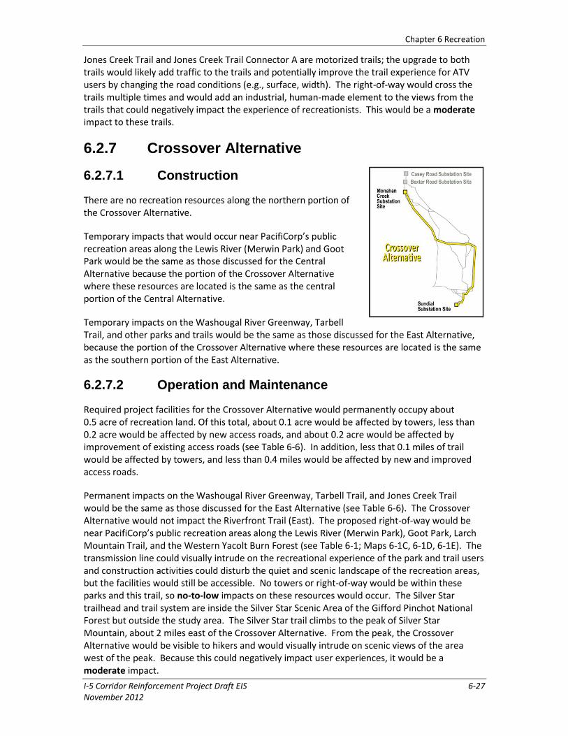
6.2.7 Crossover Alternative
6.2.7.1 Construction
There are no recreation resources along the northern portion of the Crossover Alternative.
Temporary impacts that would occur near PacifiCorp’s public recreation areas along the Lewis River (Merwin Park) and Goot Park would be the same as those discussed for the Central Alternative because the portion of the Crossover Alternative where these resources are located is the same as the central portion of the Central Alternative.
Temporary impacts on the Washougal River Greenway, Tarbell Trail, and other parks and trails would be the same as those discussed for the East Alternative, because the portion of the Crossover Alternative where these resources are located is the same as the southern portion of the East Alternative.
6.2.7.2 Operation and Maintenance
Required project facilities for the Crossover Alternative would permanently occupy about 0.5 acre of recreation land. Of this total, about 0.1 acre would be affected by towers, less than 0.2 acre would be affected by new access roads, and about 0.2 acre would be affected by improvement of existing access roads (see Table 6-6). In addition, less that 0.1 miles of trail would be affected by towers, and less than 0.4 miles would be affected by new and improved access roads.
Permanent impacts on the Washougal River Greenway, Tarbell Trail, and Jones Creek Trail would be the same as those discussed for the East Alternative (see Table 6-6). The Crossover Alternative would not impact the Riverfront Trail (East). The proposed right-of-way would be near PacifiCorp’s public recreation areas along the Lewis River (Merwin Park), Goot Park, Larch Mountain Trail, and the Western Yacolt Burn Forest (see Table 6-1; Maps 6-1C, 6-1D, 6-1E). The transmission line could visually intrude on the recreational experience of the park and trail users and construction activities could disturb the quiet and scenic landscape of the recreation areas, but the facilities would still be accessible. No towers or right-of-way would be within these parks and this trail, so no-to-low impacts on these resources would occur. The Silver Star trailhead and trail system are inside the Silver Star Scenic Area of the Gifford Pinchot National Forest but outside the study area. The Silver Star trail climbs to the peak of Silver Star Mountain, about 2 miles east of the Crossover Alternative. From the peak, the Crossover Alternative would be visible to hikers and would visually intrude on scenic views of the area west of the peak. Because this could negatively impact user experiences, it would be a moderate impact.

Chapter 6 Recreation
6-28 I-5 Corridor Reinforcement Project Draft EIS November 2012
Because the Crossover Alternative is close to trails and parks, the right-of-way would provide increased access to the forested areas of the parks and trails, primarily the western portion of the Yacolt Burn State Forest. This would cause increased access for hunting and ATV use on these otherwise inaccessible lands. The Yacolt Burn State Forest is open to motorized users during the summer, beginning on May 1 of each year, and closes in the fall when conditions become wet. Increased access to these areas by motorized users would be a positive impact during the summer months when motorized access is permitted. However, during the seasons when this area is closed to motorized users, improved access could allow unauthorized use, which would be a moderate impact. Signs, gates, and fencing may limit some potential impact.
6.2.7.3 Crossover Option 1
Crossover Option 1 would remove a portion of the alternative crossing north–south through rural residential areas north of Camas between NE Zeek Road and SE 23rd Street, and replace it with a route running west along an existing right-of-way until about NE 232nd Avenue, then southeast through open fields and more rural residential areas. Crossover Option 1 would modify part of the route north of Camas and Washougal. The right-of-way would follow part of the east boundary of Camp Currie (see Maps 6-1D and 6-1E). Tower construction would temporarily disturb about 1.5 acres of the camp. About 1.2 acres of the camp would be permanently converted to towers and new access roads (see Table 6-6). This would be a moderate impact on the camp because the right-of-way would follow existing right-of-way along the edge of the camp property.
6.2.7.4 Crossover Options 2 and 3
Crossover Options 2 and 3 would begin at the Baxter Road substation site and the new transmission line would cross sparsely populated land. Crossover Option 3 would require some additional new right-of-way. Crossover Options 2 and 3 would have no additional impacts since there are no parks or trails along either option.
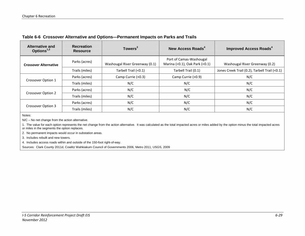
Chapter 6 Recreation
I-5 Corridor Reinforcement Project Draft EIS 6-29 November 2012
Table 6-6 Crossover Alternative and Options—Permanent Impacts on Parks and Trails
Alternative and Options
1,2
Recreation Resource
Towers3 New Access Roads
4 Improved Access Roads
4
Crossover Alternative Parks (acres)
Washougal River Greenway (0.1) Port of Camas-Washougal
Marina (<0.1), Oak Park (<0.1) Washougal River Greenway (0.2)
Trails (miles) Tarbell Trail (<0.1) Tarbell Trail (0.1) Jones Creek Trail (0.2), Tarbell Trail (<0.1)
Crossover Option 1 Parks (acres) Camp Currie (+0.3) Camp Currie (+0.9) N/C
Trails (miles) N/C N/C N/C
Crossover Option 2 Parks (acres) N/C N/C N/C
Trails (miles) N/C N/C N/C
Crossover Option 3 Parks (acres) N/C N/C N/C
Trails (miles) N/C N/C N/C
Notes:
N/C – No net change from the action alternative.
1. The value for each option represents the net change from the action alternative. It was calculated as the total impacted acres or miles added by the option minus the total impacted acres or miles in the segments the option replaces.
2. No permanent impacts would occur in substation areas.
3. Includes rebuilt and new towers.
4. Includes access roads within and outside of the 150-foot right-of-way.
Sources: Clark County 2011d, Cowlitz Wahkiakum Council of Governments 2006, Metro 2011, USGS, 2009

Chapter 6 Recreation
6-30 I-5 Corridor Reinforcement Project Draft EIS November 2012
6.2.8 Recommended Mitigation Measures
Mitigation measures included as part of the project are identified in Table 3-2. The following additional mitigation measures have been identified to further reduce or eliminate adverse impacts on recreation by the action alternatives. If implemented, these measures would be completed before, during, or immediately after project construction unless otherwise noted.
If desired by local governments or property owners, make sections of the right-of-way available for hiking and biking activities in selected areas.
Coordinate with agencies managing recreation resources to inform the public about construction closures.
Discuss locations of new towers, substations, and access roads with land managers and owners to avoid sensitive recreation areas.
Place towers so that they would not be visible from nearby recreation areas where possible.
Preserve existing vegetation (except weeds) along the roadway if possible to screen the transmission lines and towers. Allow the growth of dense masses of medium shrubs parallel to the roadway where the transmission line right-of-way crosses.
Use techniques to re-vegetate cut and fill slopes on access roads and near tower locations.
Minimize access road placement in highly sensitive recreation areas.
Implement signage, gates, and fencing where necessary to prevent unauthorized access to previously inaccessible areas via the new right-of-way.
6.2.9 Unavoidable Impacts
Temporary construction activity (noise, dust, visual intrusions, traffic) would impact users’ experiences at recreation sites and along the Columbia River and scenic drives. For all action alternatives, portions of a new transmission line would be introduced to areas where such infrastructure does not currently exist. Existing recreation areas at these locations would be altered by the placement of transmission towers, access roads, and right-of-way restrictions. Most permanent impacts on recreation would be experiential intrusions to the scenic character of the area from the transmission towers and lines (see Chapter 7, Visual Resources). These intrusions would occur at specific recreation sites and for general dispersed or informal recreational uses, such as the Lewis and Clark Trail Scenic Byway, Columbia River Gorge Scenic Byway, and the Columbia River.
6.2.10 No Action Alternative
Under the No Action Alternative, the project would not be constructed and there would be no impact on recreation. Authorized and unauthorized recreational activities would continue to occur in the project area. As the area continues to grow, more recreation resources may be developed. Dispersed recreation would likely continue to grow.


