CHAPTER 6: Access Management
22
Alpena Area-Wide Comprehensive Transportation Plan 6-1 Chapter 6 CHAPTER 6: Access Management Introduction Access management provides a systematic approach to balancing the access and mobility necessities of a roadway. Access management can be defined as the process of managing access to land development, while simultaneously preserving the flow of traffic on the surrounding public road system. Property owners have a “right to reasonable” access to the general system of streets and highways. At the same time, adjacent roadway users have the right to freedom of movement, safety, and efficient expenditure of public funds. Balancing these interests is critical at locations where significant changes to the transportation system and/or surrounding land uses are occurring. The safe and efficient operation of the transportation system calls for effectively managing highway access, via driveways, streets, or other access points. The specific techniques for managing access involve the application of established traffic engineering and planning principles. Ideally, these principles will: • Limit the number of traffic conflicts (driveways and roadway turning movements); • Separate basic conflict areas; • Separate turning volumes from through movements; • Provide sufficient spacing between at-grade intersections, including driveways; • Maintain progressive safe traffic flow along arterials; • Provide adequate on-site storage areas with good internal circulation. The application of these principles will minimize disruptions to through traffic caused by access drives and intersections. More specifically, good access management can: • Reduce crashes and crash potential; • Preserve roadway capacity and the useful life of roads; • Decrease travel time and congestion; • Improve access to properties; • Coordinate land use and transportation decisions; • Improve air quality; • Maintain travel efficiency and related economic prosperity.
Transcript of CHAPTER 6: Access Management

Alpena Area-Wide Comprehensive Transportation Plan
6-1 Chapter 6
CHAPTER 6: Access Management
Introduction
Access management provides a systematic approach to balancing the access andmobility necessities of a roadway. Access management can be defined as the processof managing access to land development, while simultaneously preserving the flow oftraffic on the surrounding public road system.
Property owners have a “right to reasonable” access to the general system of streetsand highways. At the same time, adjacent roadway users have the right to freedom ofmovement, safety, and efficient expenditure of public funds. Balancing these interests iscritical at locations where significant changes to the transportation system and/orsurrounding land uses are occurring. The safe and efficient operation of thetransportation system calls for effectively managing highway access, via driveways,streets, or other access points.
The specific techniques for managing access involve the application of established trafficengineering and planning principles. Ideally, these principles will:
• Limit the number of traffic conflicts (driveways and roadway turning movements);• Separate basic conflict areas;• Separate turning volumes from through movements;• Provide sufficient spacing between at-grade intersections, including driveways;• Maintain progressive safe traffic flow along arterials;• Provide adequate on-site storage areas with good internal circulation.
The application of these principles will minimize disruptions to through traffic caused byaccess drives and intersections. More specifically, good access management can:
• Reduce crashes and crash potential;• Preserve roadway capacity and the useful life of roads;• Decrease travel time and congestion;• Improve access to properties;• Coordinate land use and transportation decisions;• Improve air quality;• Maintain travel efficiency and related economic prosperity.

Alpena Area-Wide Comprehensive Transportation Plan
6-2 Chapter 6
Driveway Spacing
Access management increases the spacing between driveways, thus reducing thenumber and variety of events to which drivers along the corridor must respond. Closespacing between unsignalized driveways forces the driver to watch for ingress andegress traffic at several locations simultaneously. Increased spacing translates intofewer accidents, savings in travel time, and preservation of corridor capacity.
Driveways should be located to limit interference with the free movement of roadwaytraffic, and to provide the most favorable sight distance and driveway grade. No directaccess drive should be located in the operational area of a signalized intersection.
Driveway spacing and location standards are based upon several factors. These includecharacteristics such as site frontage, roadway width, roadway classification, driver sightdistance, and (most importantly) roadway speed. The following is a discussion ofvarious factors that dictate driveway spacing and location.
Roadway Speed
The prevailing speed on the roadway is a primary factor in determining proper drivewayspacing. Naturally, the higher the speed of the roadway, the more distance that isrequired for a motorist to react to changing traffic conditions. Thus, greater drivewayspacing is required for higher speeds. Local driveway spacing standards can be derivedfrom a variety of references, including MDOT’s Access Management Guidebook. Table6.1 displays desirable separation distances for access drives and Figure 6.1 displaysthe recommended driveway spacing for the rural areas where the speed limit is 55 mph.
Table 6.1 Desirable Separation of Adjacent Driveways
Highway Speed Minimum Driveway Spacing
25 mph 135 feet
30 mph 185 feet
35 mph 245 feet
40 mph 300 feet
45 mph 350 feet
50 mph & above 455 feet

Alpena Area-Wide Comprehensive Transportation Plan
6-3 Chapter 6
4 5 5 ’ M i n i m u m a l o n gM - 3 2 a n d U S - 2 3S p e e d s 5 0 M P H
a n d g r e a t e r
2 5 0 ’ M i n i m u ma l o n g c o r r i d o r s
M i n i m u m o f f s e t w h e r ed i r e c t a l i g n m e n t o f
d r i v e w a y s i s n o tp o s s i b l e

Alpena Area-Wide Comprehensive Transportation Plan
6-4 Chapter 6
All site plans for proposed developments should show the location of all proposed andexisting driveways within the area of the proposed development. The location of all ofthe proposed driveways should be reviewed to determine if proper driveway spacing willbe maintained.
Sight Distance
Access drives should be placed at locations that provide adequate intersection andstopping sight distance. These locations often occur at the top or bottom of inclines. Inhilly areas, proper locations can be at a premium, and shared access might benecessary. Often, the best locations for sight distance may create unfavorable drivewaygrades on the site. Due to the relatively level topographic relief in the study area, thisdoes not appear to be a problem. Another potential issue might involve the trimming ofbrush or vegetation near intersections, within the highway right-of-way, so thatapproaching motorists have an adequate view of other approaching vehicles.
The required stopping sight distance (the sum of brake reaction distance and brakingdistance) is listed in the MDOT publication Access Management Guidebook, 2001:
Design Speed Stopping Sight Distance for Design25 mph 155 feet30 mph 200 feet35 mph 250 feet45 mph 360 feet50 mph 425 feet55 mph 495 feet65 mph 645 feet70 mph 730 feet
Location of Nearby Intersections
As previously stated, access driveways should not be placed in the area of operation ofan adjacent intersection. Greater spacing may be required due to stacking requirementsof the approaches to the intersection. This can be particularly evident around signalizedintersections.
Achieving proper corner clearance involves regulating the distance between a crossroadintersection and the nearest driveway location. Corner clearance is defined as thedistance, measured along the back of the arterial curb, from the nearest edge of anaccess drive to the nearest edge of the intersection.
Moving the basic driveway conflict area away from the vicinity of an intersection can beaccomplished by regulating the distance from the driveway to the intersection. Themajor effect is that vehicles will be delayed less by standing queues at signalizedintersections. A possible tradeoff is that access to some corner commercial propertiesmay be partially or totally denied access.
Minimum driveway setbacks should be considered at individual intersections, and shouldbe based on typical queue lengths that still allows sufficient movement to and from adriveway. In rural areas, minimum corner clearances of 300 feet on major arterials and

Alpena Area-Wide Comprehensive Transportation Plan
6-5 Chapter 6
200 feet on the side roads should be maintained. In many instances, the minimumcorner clearance will be governed by the clear vision corners.
In urban areas such as near the City of Alpena, slightly shorter corner clearances areacceptable as speed limits decrease, depending on the particular intersection. Thelocation of existing driveways and the amount of available roadway frontage that theproperty has will dictate this. Each proposed driveway will need to be reviewed on anindividual basis.
Type and Size of Development
Location and spacing requirements are more critical for access driveways to largedevelopments or high traffic generators such as Wal-Mart and Home Depot. Thesedriveways often operate as major intersections themselves, with signalization sometimespresent. Greater spacing must be provided to allow for left turn storage on the mainroadway and to reduce conflict points.
Maximum Number of Access Drives Per Property Frontage
This general access control standard limits the number of driveways per property relativeto the length of available frontage. Regulating the number of driveways permitted for aspecific frontage could have a significant impact on the business activity at that location.This should be considered before denial for an additional driveway is given, or before anexisting driveway is closed. The allowable number of access drives typically follows therecommendations outlined below:
• Normally, only one driveway is permitted for residential usage and, depending uponsite conditions, two may be permitted for non-residential usage.
• If property frontage exceeds 600 feet, additional driveways may be permitted.• Development may be restricted to a single ingress/egress point if served by an
adequate collector road or side street.
Driveway Design
Establishing access drive design criteria is essential in improving traffic operations andsafety. Design standards outline geometric requirements regarding driveway widths,corner radii, taper lengths, and passing lanes to name a few. Driveways directlyaccessing either corridor must follow MDOT’s driveway design standards listed in the,“Rules Regulating Driveways, Banners, and Parades, 1998.” The following is adiscussion of driveway design standards for typical access locations.
Commercial Driveways
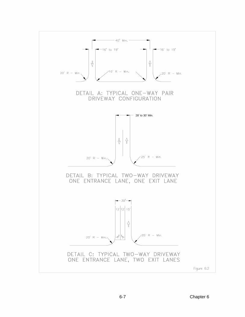
Width - All commercial driveways should have a width sufficient for the particular landuse and anticipated traffic flow with a minimum width of 16 feet for a one-way drive and25 feet for a two-way drive. The maximum width should be 19 feet for a one-way driveand 36 feet for a two-way drive. As an exception, 39 feet may be allowed or required toprovide for an entrance lane and two exit lanes. These widths should be measured atright angles to the centerline of the driveway at the right-of-way line.

Alpena Area-Wide Comprehensive Transportation Plan
6-6 Chapter 6
Radii - All commercial driveways should have radii large enough to accommodate thelargest vehicle that will normally use it without creating undue congestion or hazard onthe through highway. The minimum entrance radius allowed should be 25 feet and theminimum exit radius allowed should be 20 feet.
Tapers, Deceleration Lanes, and Passing Lanes - When a commercial establishment willgenerate high traffic volumes, deceleration tapers may be required. Larger commercialestablishments may require deceleration lanes and passing lanes opposite the drivewayto facilitate the anticipated traffic flow. These design considerations are addressed indetail in ensuing sections.
Angled Driveways - When the property owner desires to construct dual commercialdriveways at other than 90 degrees to the centerline of the road, the near driveway onthe right side as approaching should not have less than a 45 degree angle with thecenterline of the road and the far driveway should not have less than a 60 degree anglewith the centerline of the road.
Profile - All commercial driveways should be built to a sidewalk elevation at the right-of-way line. Beyond the right-of-way line, the grade should not exceed 8 percent. Someexamples of layouts for driveways are shown in Figure 6.2 and Figure 6.3.
Private Street Entrances
A private street entrance is defined as any driveway serving two or more residentialparcels.
Width - The minimum width allowed is 22 feet and the maximum width allowed is 30 feet.
Radii - The minimum entrance radius allowed is 20 feet. The minimum exit radiusallowed is 15 feet.
Residential Driveways
A residential driveway is defined as any driveway serving the residents of a single ortwo-family dwelling, or a farmyard adjacent to a farm resident.
Width - All residential driveways should have a minimum width of 10 feet and amaximum width of 20 feet, measured at right angles to the centerline of the driveway atthe right-of-way line.
Offset - To facilitate vehicle movements, the driveway approach should be offset fromthe near side of the driveway 8 feet and from the far side of the driveway 4 feet;measured at the pavement edge.
Profile - All residential driveways should be built to a sidewalk elevation at the right-of-way line.
Alpena Area-Wide Comprehensive Transportation Plan
6-7 Chapter 6
28’ to 30’ Min.

Alpena Area-Wide Comprehensive Transportation Plan
6-8 Chapter 6

Alpena Area-Wide Comprehensive Transportation Plan
6-9 Chapter 6
Joint Driveways
When both property owners abutting a common property line agree, they may constructa joint commercial driveway that should meet these rules as if their frontages were undera single ownership. Joint driveways may be either commercial or residential, however, acommercial lot should not share a driveway with a residential lot. When consolidatingresidential driveways, consideration must be given to social issues such as maintenanceand conflicts over usage. Driveway consolidation is addressed in detail later in thefollowing section of this report.
Driveway Consolidation
Shared access drives are used to reduce the number of access points along a corridorwhile maintaining reasonable access to adjacent land uses. A shared access drivegenerally serves only two land uses that individually generate a relatively low number oftrips.
As stated previously, a joint commercial driveway may be constructed if both propertyowners abutting a common property line agree. This general operating practiceencourages adjacent property owners to construct shared driveways in lieu of separatedriveways. Strategies for implementing this access control measure include closingexisting driveways or authorizing joint-use driveways. The feasibility of this measure isviewed primarily at the permit-authorization stage. A shared access drive will result in areduction in the concentration of driveways along a roadway, thus reducing thefrequency and severity of conflicts.The physical means by which access can be consolidated between two adjacentproperties involves the construction of a joint-use driveway between the two properties.It is recommended that both property owners own the shared access drive. That is, thedriveway should straddle the property line dividing the two establishments. The resultingjoint-use parking area should be accompanied by an efficient internal circulation plan.
Service Roads
Service or frontage roads provide access and internal circulation to a number ofdevelopments. Service drives and frontage roads are useful because they provide apathway to many sites while minimizing the number of access drives along the corridor.Service drives may be appropriate when a concentration of establishments exists. Iflocations exist where heavy traffic enters and exits various sites in a concentrated area,it is desirable to divert this traffic off of the main roadway so that the turning movementswill occur off of the main roadway. The service drive may be configured such thatdevelopment traffic can access the main roadway at a signalized intersection wheremovements can be controlled, or at a collector road (side street).
Service drives are usually constructed and maintained by the property owner or anassociation of adjacent owners. The service drive itself should be constructed to publicroadway standards in regard to both cross section and materials design, as well asalignment. Since, by definition, these internal roadways would be serving several useswith numerous driveways, any additional use such as on-street parking should beprohibited. The alignment of service and frontage drives should be based on severalfactors including presence of existing buildings, location of property lines, existing

Alpena Area-Wide Comprehensive Transportation Plan
6-10 Chapter 6
wetlands constraints, and maximizing service drive operations. Some typical serviceroad applications are shown in Figure 6.4.
Auxiliary Lanes
Right Turn Deceleration Taper
The following is a guideline for requiring the installation of a right turn deceleration taperalong arterials or collectors approaching an access drive. Deceleration tapers reducethe potential for rear end collisions by removing turning vehicles from the high speedthrough lanes. Deceleration tapers are recommended when the right turn volume into adriveway exceeds 300 vehicles per day. The length of these tapers is based on thetravelling speed of the roadway. Table 6.2 displays desirable taper lengths as a functionof roadway speed and Figure 6.5 displays the typical layout for the right turn lanes anddeceleration tapers. Also included in Figure 6.5 is a Warrant Graph for determining theneed for a right-turn lane or deceleration taper.
Table 6.2 Desirable Deceleration Taper Lengths
Highway Speed Taper Length
30 mph 50 feet
35 mph 75 feet
40 mph 100 feet
45 mph 130 feet
50 mph 180 feet
55 mph 225 feet
Right Turn Deceleration Lane
The following is a guideline for requiring the installation of a right turn deceleration lane.Deceleration lanes also reduce the potential for rear end collisions by removing turningvehicles from the high speed through lanes. Deceleration lanes are recommended whenthe right turn volume into a driveway exceeds 600 vehicles per day. The length of adeceleration lane can vary from 75 to 250 feet and is dependent on the amount ofstacking required for vehicles entering the driveway. Deceleration lanes are oftenplaced at signalized access points. Tapers of the appropriate length should be placed inadvance of these lanes.

Alpena Area-Wide Comprehensive Transportation Plan
6-11 Chapter 6

Alpena Area-Wide Comprehensive Transportation Plan
6-12 Chapter 6

Alpena Area-Wide Comprehensive Transportation Plan
6-13 Chapter 6
Two-Way Left Turn lane
The following is a guideline for requiring the installation of a two-way left turn lane.Center left- turn lanes are provided to remove left turning vehicles from through trafficlanes and store them in the median area until an acceptable gap appears. A center leftturn lane completely shadows turning vehicles from both through traffic streams resultingin less accidents. Delay to through vehicular traffic would also be reduced since leftturning vehicle queues would not block the through lanes.
A center left turn lane is warranted on multi-lane highways that have closely spaceddriveways with a uniform and medium density of left turns along the highway. Highwayvolumes and speeds should exceed 10,000 vehicles per day and 30 miles per hourrespectively. High accident rates involving left turn maneuvers also warrant a center leftturn lane.
Additional Exit Lane for an Access Drive
The following is a guideline for determining whether an additional egress lane should beestablished for an access drive. Additional lanes allow right turn or left turn egressmaneuvers to be made more efficiently because drivers are not delayed by egressvehicles wanting to turn in alternate directions. The egress capacity of the driveway isalso significantly increased. Total driveway delay should decrease significantly becauseof the increased capacity due to the separation of egress turning traffic.
This technique is applicable for all highway types and at driveway locations whereegress maneuvers are hindered because separate turning lanes are not provided.Highway speeds should normally exceed 30 miles per hour with highway volumessurpassing 5,000 vehicles per day. Existing driveway volumes should exceed 1,000vehicles per day (approximately 500 egress trips).

Alpena Area-Wide Comprehensive Transportation Plan
6-14 Chapter 6
Medians
One approach to managing access is to use medians of various designs to limit left-turnvehicle movements, channel traffic so that it flows more efficiently, and provide crosswalk ‘safe havens’ for pedestrians and bicyclists. Landscaped green medians alsoprovide for a more beautiful community and tend to ‘calm’ or slow the speed of throughtraffic.
Some cross-section examples of medians can be seen in Figure 6.6, from the AASHTOGeometric Design of Highways and Streets manual, 1994 edition. These types ofmedians are used to separate and channel traffic on arterial roadways. According to themanual:
The principal advantages of dividing the multilane arterial are increasedsafety, comfort, and ease of operation. Of significance is the reduction inhead-on collisions and virtual elimination of such accidents on sectionswith wide medians. These accidents usually are serious. Where medianlanes for left turns are provided, rear-end collisions and other inconven-iences to through traffic resulting from left-turn movements are greatly
reduced. Pedestrians crossing the divided arterial are required to watchtraffic in only one direction at a time and are given a welcome respite atthe median. Where the median is wide enough, crossing and left-turningvehicles can slow down or stop between the one-way pavements to takeadvantage of breaks in traffic and cross when it is safe to do so. Dividedmultilane arterials make for more relaxed and pleasant operation, partic-ularly in inclement weather and at night when headlight glare is bother-some. Headlight glare is reduced somewhat by narrow medians but can
almost be eliminated by wide medians.
The National Highway Institute (NHI), in Course No. 15255, reports that not only do theuse of curbed medians and channelized intersections increase operational safety, butcapacity of the roadway is also increased. The reason for this is that highway traffic flowis smoothed by having decreased traffic conflicts. Opposing lanes are separated, trafficis automatically regulated by physically prohibiting certain movements, motorists aremore aware of the proper use of travel lanes and intersections, turning movements arepositively controlled, and pedestrians are protected by a safe refuge area.

Alpena Area-Wide Comprehensive Transportation Plan
6-15 Chapter 6
Figure 6.6, Typical Medians on Divided ArterialsSource: AASHTO, Geometric Design of Highways and Streets, 2001
The following two graphs (Figure 6.7) show the motorist and pedestrian safety benefitsof retrofitting arterials that had a two-way left turn lane (TWLTL) with a raised median.
Figure 6.7, Safety Benefits of Medians
0
2
4
6
8
10
12
4 Lane
Highway
6 Lane
Highway
TWLTL
Raised Median
Crash Rates on Michigan Highways
Source: J.D. Benac, 1988 (MDOT)
Per Million Vehicle Miles
9.56
11.07
4.07
5.63
0
2
4
6
8
10
12
14
16
18
Total MidBlock
Undivided Hwy
TWLTL
Raised Median
Florida Pedestrian Safety Study
Source: Long, Gen, & Morrison 1993 (University of Florida)
Crash Rates Per 100 Million Vehicle Miles for 4 Lane Highways
18
10
4
11
6
2

Alpena Area-Wide Comprehensive Transportation Plan
6-16 Chapter 6
There is always some concern that good access management, while enhancing safety,can be a detriment to economic development. In fact, good access managementtechniques including the use of medians to channel traffic and limit left turningmovements can be beneficial or at least not harmful to businesses located along themanaged arterial roadway, according to a 1996 study by the Iowa Department ofTransportation (IDOT). The IDOT study compared business owners’ opinions onroadways in several municipalities on which access management improvements weremade. In almost all cases before the changes were made, the business owners felt thatlimiting turning movements would harm their business. After the improvements weremade, however, the vast majority (86%) felt that their business sales had either stayedthe same (53%) or had increased (33%). Another 9% were uncertain, and 5% felt thattheir sales had been hurt by the improvements (see Figure 6.8)
Figure 6.8, Business survey conducted in Iowa municipalities;Source: Iowa Access Management Research & Awareness Project 1996, IDOT
Trees and Landscaping
According to Walkable Communities, Inc., motorists will drive a safer and more prudentspeed on a roadway with street tree plantings than on one without plantings, on anotherwise identically designed roadway. Speed limit signs make little difference, sincemotorists tend to drive at a speed that seems comfortable regardless of the postedspeed limit. Trees and other landscaping gives motorists the impression that theroadway is narrower, and therefore it feels more comfortable to drive at a lower speed.
Closely planted trees along a roadway can also provide the motorist with a sense ofspeed when the trees appear to be going by very quickly, causing the motorist to drive alittle slower. Interestingly, slower vehicles do not necessarily decrease the capacity of aroadway. This is because a smaller gap is possible between vehicles, allowing for agreater volume of traffic in any given segment. If tree plantings are used in combinationwith good access management designs, traffic will consist of a constant smooth flow ofclosely spaced vehicles. Studies show that this is a much safer condition than fastmoving traffic that is forced to periodically stop and start again due to conflicts withmerging and turning vehicles.
Impact on business sales, all cases:Corridors with completed access
management projects
Increased
Stayed Same
Decreased
Uncertain
33%
53%
9%5%

Alpena Area-Wide Comprehensive Transportation Plan
6-17 Chapter 6
Traffic Signals
In general, traffic signals should only be placed where warranted, and at a sufficientdistance from each other to preserve the traffic capacity of corridors in the study area.Traffic signals placed too closely together will decrease traffic progression and increasemotorist delay. Traffic progression must always be considered when deciding theplacement of a new signal.
Thresholds for Requiring Traffic Impact Studies
The following discussion consists of pertinent excerpts from Evaluating Traffic ImpactStudies: A Recommended Practice for Michigan Communities (McKenna Associates;1994). This manual was sponsored by Tri-County Regional Planning, the MichiganDepartment of Transportation, and the Southeast Michigan Council of Governments, andis a widely used and accepted guide for requiring, conducting, and evaluating trafficimpact studies.
Communities often are concerned with the traffic implications of land use decisions. Insome cases, communities deny proposed development based on perceived trafficimpacts without having a clear understanding of how to evaluate and mitigate trafficimpacts. Conversely, some developments are established that result in unforeseentraffic consequences to the street system.
A traffic impact analysis is a specialized study that assesses the effects that a particulardevelopment will have on the surrounding transportation network. The lack of uniformrequirements and procedures for traffic impact studies result in a number of problems,some of which include:
• Some communities require traffic impact studies only after there is a problem.• Some communities require traffic impact studies for very small scale projects which
have ultimately negligible impacts on the roadway.• Some communities allow very large-scale projects to be developed without
evaluating likely traffic impacts and necessary mitigation for predicted future traffic.• The lack of uniform procedures may lead to unnecessary analyses, costs, and
delays during both preparation and review of site plans.
The purpose of this section is to provide guidelines for requiring traffic impact studies aswell as determining what type of study should be required.

Alpena Area-Wide Comprehensive Transportation Plan
6-18 Chapter 6
Types of Traffic Impact Studies
Four basic types of traffic studies exist. They are described below.
Rezoning Traffic Study - A traffic study for a rezoning request is different than one for aspecific use. A community needs to consider all of the uses that potentially could bedeveloped under the requested zoning district, regardless of any specific use beingproposed. A traffic study for rezoning should compare the potential trip generation ofland uses allowed under the requested zoning, with those uses allowed under thepermitted zoning. The community staff or the planning commission may want to identifythree to four typical uses in both the current and requested zoning district.
Traffic Impact Assessment - This type of study is recommended for smaller scaleprojects which should not have a significant impact on the overall transportation system,but will have impacts at the site access points. The analysis for this type of studyfocuses on the proposed site driveways.
Traffic Impact Statement - This is the traditional traffic impact study that evaluatesimpacts at site access points as well as appropriate nearby intersections.
Regional Traffic Analysis - This type of study is recommended for very large regionaldevelopments such as large shopping malls and arenas. The study evaluates theimpacts on the local streets and the regional transportation facilities such as freewaysand major through arterials.
Trip Generation Thresholds
The trip generation of a proposed development is the number of inbound and outboundvehicle trips that are expected to be generated by a development throughout an averageday or during a peak hour. The process of using trip generation thresholds is as follows:
• Estimate the trip generation for the proposed development.• Compare that generation to excepted thresholds.• Determine the type (if any) of traffic study needed.
Trip generation thresholds are commonly used as discussed below.
Thresholds for Rezoning Requests
Evaluating the traffic impacts of a proposed rezoning is difficult to determine since arezoning usually permits any one of a number of uses. The following are recommendedthresholds for requiring a rezoning traffic study.
• Requests for a rezoning consistent with the long-range land use plan whencommunity officials believe the timing of the change may not be appropriate due totraffic issues. This threshold is recommended only for a rezoning which permits usesthat could generate 100 or more additional trips in a peak hour, or at least 1,000more additional trips per day than would be generated by the majority of the usespermitted under current zoning.

Alpena Area-Wide Comprehensive Transportation Plan
6-19 Chapter 6
• Requests for a rezoning which are inconsistent with the community master plan for asite that could generate at least 100 directional trips during the peak hour, or over750 trips in an average day.
• Proposed rezoning along a roadway that the community has identified as a criticalcorridor, congested corridor, or safety management corridor. This could be appliedto all such rezonings or only those which would generate additional traffic as noted inthe previous paragraph.
• Proposed amendments to the future land use plan that would recommend uses thatgenerate higher traffic volumes.
Thresholds for Site Plans, Plats, Mobile Home Parks, and Condominium Projects
Traffic studies for site plans, plats, mobile home parks, and condominium projectsshould be more detailed than those for rezoning since the use and proposed site designare established. Thus, even if an initial traffic study was completed for a rezoning, amore detailed study would usually be required for the site plan. The following thresholdsfor requiring a traffic impact statement are recommended for most cases.
• Any proposed site plan or subdivision plan which would be expected to generateover 100 directional trips during the peak hour, or over 750 trips in an average day.A less detailed study (traffic impact assessment) is recommended for projects whichcould generate 50-99 directional trips during a peak hour or 500-749 trips during anaverage day.
• A change in an approved Planned Unit Development (PUD) to a more intense use(on a case-by-case basis).
• Any proposed development along a corridor identified in the community master planor long range transportation plan as a critical, congested, or safety managementcorridor which would be expected to generate over 50 directional trips during thepeak hour, or over 500 trips in an average day.
• For new phases or changes to a development where a traffic study is more than twoyears old and roadway conditions have changed significantly (volumes increasingmore than two percent annually).
• A change in use or expansion at an existing site where traffic is expected to increaseby at least 50 directional trips in a peak hour.
• Special land uses, conditional land uses, planned unit developments, and other useswhich are required to provide a traffic impact study in the zoning ordinance.
• Where required by the road agency to evaluate access issues. Typically this isbased on an access code, administrative rules, or policy.
Table 6.3, on the following pages, shows the development size, for various land uses,necessary to meet or exceed the three trip generation thresholds to be used todetermine which study should be required. Table 6.3 can be used by planningcommissions and developers as a reference for “break points” in the type of analysis thatshould be preformed. However, for consistency, the most current edition of TripGeneration by the Institute of Transportation Engineers should be used to calculate tripgenerations, unless there is local data which warrants consideration of other factors.

Alpena Area-Wide Comprehensive Transportation Plan
6-20 Chapter 6
Table 6.4 summarizes the trip generation thresholds for requiring either a traffic impactassessment or a traffic impact statement, as well as the tasks that would be required forthe respective study. As an example, according to the Tables 6.3 and 6.4, a full trafficimpact study should be completed if 150 or more single family units are proposed for asite (which would likely generate 100 trips during the peak hour in the peak direction).
Table 6.3 Land Use Thresholds Based on Trip Generation Characteristics
Land Use Land UseVariable
50 TripsDuring PeakHour in PeakDirection
100 TripsDuring PeakHour in PeakDirection
750 Daily Trips
Residential: Single Family units 70 150 70
Residential: Apartments units 115 245 120
Residential: Condominiums/Townhouses units 125 295 120
Residential: Mobile Home Park units 140 305 150
Shopping Center gross leasablearea (sq. ft.)
5,200 15,500 2,700
Fast Food Restaurant w/ Drive-Thru gross floor area(sq. ft.)
2,600 5,200 1,200
Convenience Store w/ gas Pumps gross floor area(sq. ft.)
650(or 3 pumps)
1,300(or 5 pumps)
1,000
Bank w/ drive-in gross floor area(sq. ft.)
2,200 4,400 2,800
Hotel/Motel rooms 120 250 90
General Office gross floor area(sq. ft.)
22,000 55,000 45,000
Medical/Dental Office gross floor area(sq. ft.)
18,600 37,000 26,000
Research and Development gross floor area(sq. ft.)
37,000(or 1.5 acres)
85,000(or 4.5 acres)
70,000(or 4 acres)
Light Industry gross floor area(sq. ft.)
58,000(or 4 acres)
115,000(or 8 acres)
115,000(or 11.5 acres)
Manufacturing gross floor area(sq. ft.)
125,000 250,000 195,000

Alpena Area-Wide Comprehensive Transportation Plan
6-21 Chapter 6
Table 6.4 Requirements for Various Types of Traffic Impact Studies
Trip Threshold (Based on Trip Generation Rates- Land Use ThresholdTable 6.3)
Task Rezoning TrafficStudy
Traffic ImpactAssessment
50-99 Peak Hour,Peak Direction or500-749 Daily
Traffic ImpactStatement
100+ Peak Hour, PeakDirection or 750+Daily
Impact Analyses:
Existing conditions analysis at site (levels ofservice as determined by techniques outlined in the Highway
Capacity Manual)
O X X
Sight distance evaluation X X X
Opposing driveway locations X X
Existing conditions at nearby intersections O X
Study area & future road summary X
Comparison of trip generation associated withuses allowed, requested v. current permitted
uses
X
Trip generation for specific uses X X
Trip distribution analysis O X X
Background traffic growth O X
Future conditions analysis at nearbyintersections
O X
Mitigation identification and evaluation O X X
Site Issues:
Evaluate number, location, and spacing ofaccess points
O X X
Evaluate access design, queuing, etc. X X
Evaluate site circulation O O
Other Analyses:
Accident history O
Gap analysis for unsignalized locations O O
Evaluate long-range traffic impacts oncomputer model - MDOT/MPO participation
O O
Key: X required O may be appropriate on a case-by-case basis

Alpena Area-Wide Comprehensive Transportation Plan
6-22 Chapter 6
Summary
The key to access management is consistency. Following the guidelines for requiringtraffic studies and carefully considering the design and placement of each and everydriveway are also critical. Every effort must be made to provide access to adjoiningproperties with minimal impact to the roadway. As additional development occurs alongthe corridor, good opportunities will arise to implement proper access managementtechniques that will 1) limit the number of driveways, 2) separate and channel traffic, 3)cause businesses to share access driveways and parking lots, and 4) reduce the volumeof vehicles by creating good pedestrian and bicycle facilities.
References
Institute of Transportation Engineers (ITE), Guidelines for Driveway Location andDesign, ITE Technical Committee 5B-13, 1987.
Kent County Road Commission (KCRC), Rules to Regulate Driveways, Banners andParades, 1989.
McKenna Associates, Inc. et al., Evaluating Traffic Impact Studies, Tri-County RegionalPlanning, Michigan Department of Transportation (MDOT), Southeast Michigan Councilof Governments (SEMCOG), 1994.
McKenna Associates, Inc. et al., US-27 Corridor/Subarea Access Management Plan,Dewitt Charter Township, 1993.
Transportation Research Board (TRB), Planning and Implementing Pedestrian Facilitiesin Suburban and Developing Rural Areas, National Cooperative Highway ResearchProgram Report No. 294A, 1987.
Transportation Research Board (TRB), Driveway and Street Intersection Spacing,Transportation Research Circular No. 456, 1996.
Urbitran Associates, Improving Driveway and Access Management in Michigan,Michigan Department of Transportation (MDOT), 1985.
U.S. Department of Transportation (USDOT), Access Management and Traffic Analysisfor Highways, Federal Highway Administration (FHWA), and National Highway Institute(NHI), Publication No. FHWA-HI-91-012, 1991.
V. Stover and F. Koepke, Transportation and Land Development, Prentice Hall,Englewood Cliffs, New Jersey, 1988.
Dan Burden and Michael Wallwork, P.E., Creating Walkable Communities, WalkableCommunities, Inc., High Springs, Florida, 1999.
American Association of State Highway Transportation Officials (AASHTO), GeometricDesign of Highways and Streets, 2001 Edition.
Michigan Department of Transportation, Access Management Guidebook, 2001