
Chapter 5 · PRINCIPLES TO ACHIEVE THE FUNDAMENTAL ... Public transport Chapter 5 ... Figure 5.2.3...
31
Public transport Chapter 5.2 5.2
Transcript of Chapter 5 · PRINCIPLES TO ACHIEVE THE FUNDAMENTAL ... Public transport Chapter 5 ... Figure 5.2.3...

Public transport
Chapter 5.2
5.2

TABLE OF CONTENTS
INTRODUCTION. . . . . . . . . . . . . . . . . . . . . . . . . . . . . . . . . . . . . . . . . . . . . . . . . . . . . . . . . . . . . . . . . . . . 1
EVOLVING PUBLIC TRANSPORT POLICY AND ITS IMPLICATIONS FOR SETTLEMENT-PLANNING. . . . . . . . . . . . . . . . . . . . . . . . . . . . . . . . . . . . . . . . . . . . . . . . . . . . . . . . . . . . . . . . . . . . . . . . 1
White Paper on national transport policy . . . . . . . . . . . . . . . . . . . . . . . . . . . . . . . . . . . . . . . . . . . . . . . 1
Legislation. . . . . . . . . . . . . . . . . . . . . . . . . . . . . . . . . . . . . . . . . . . . . . . . . . . . . . . . . . . . . . . . . . . . . . . . 2
Moving South Africa. . . . . . . . . . . . . . . . . . . . . . . . . . . . . . . . . . . . . . . . . . . . . . . . . . . . . . . . . . . . . . . . 2
PRINCIPLES TO ACHIEVE THE FUNDAMENTAL RESTRUCTURING OF PUBLIC TRANSPORT . . . . . . . . . . . 4
PUBLIC TRANSPORT OBJECTIVES . . . . . . . . . . . . . . . . . . . . . . . . . . . . . . . . . . . . . . . . . . . . . . . . . . . . . . 7
GUIDELINES FOR PUBLIC TRANSPORT SUPPORTIVE SETTLEMENTS. . . . . . . . . . . . . . . . . . . . . . . . . . . . . 8
Planning settlements that are accessible to public transport. . . . . . . . . . . . . . . . . . . . . . . . . . . . . . . . . 8
Contextualisation and connection . . . . . . . . . . . . . . . . . . . . . . . . . . . . . . . . . . . . . . . . . . . . . . . . . . . . . 8
Public transport framework . . . . . . . . . . . . . . . . . . . . . . . . . . . . . . . . . . . . . . . . . . . . . . . . . . . . . . . . . 10
Integration of public transport and movement networks . . . . . . . . . . . . . . . . . . . . . . . . . . . . . . . . . . 12
Integration of land use and public transport . . . . . . . . . . . . . . . . . . . . . . . . . . . . . . . . . . . . . . . . . . . . 16
Providing for buses, minibuses and bus stops . . . . . . . . . . . . . . . . . . . . . . . . . . . . . . . . . . . . . . . . . . . 18
CONCLUSION. . . . . . . . . . . . . . . . . . . . . . . . . . . . . . . . . . . . . . . . . . . . . . . . . . . . . . . . . . . . . . . . . . . . . 21
BIBLIOGRAPHY . . . . . . . . . . . . . . . . . . . . . . . . . . . . . . . . . . . . . . . . . . . . . . . . . . . . . . . . . . . . . . . . . . . 22
APPENDICES . . . . . . . . . . . . . . . . . . . . . . . . . . . . . . . . . . . . . . . . . . . . . . . . . . . . . . . . . . . . . . . . . . . . . 23
i
GUIDELINES FOR HUMAN SETTLEMENT PLANNING AND DESIGN
Public transport Chapter 5.2

ii
GUIDELINES FOR HUMAN SETTLEMENT PLANNING AND DESIGN
Chapter 5.2 Public transport
LIST OF TABLES
Table 5.2.1 The relationship between public transport services and residential density . . . . . . . . . . . . . . .18
LIST OF FIGURES
Figure 5.2.1 Urban densification options . . . . . . . . . . . . . . . . . . . . . . . . . . . . . . . . . . . . . . . . . . . . . . . . . . . .3
Figure 5.2.2 Principles to achieve the public transport supportive structure necessary for fundamental restructuring . . . . . . . . . . . . . . . . . . . . . . . . . . . . . . . . . . . . . . . . . . . . . . . . . .5
Figure 5.2.3 Example of four public transport network concepts . . . . . . . . . . . . . . . . . . . . . . . . . . . . . . . . . .7
Figure 5.2.4 Context and site analysis map . . . . . . . . . . . . . . . . . . . . . . . . . . . . . . . . . . . . . . . . . . . . . . . . . . .9
Figure 5.2.5 A transport framework for settlement planning . . . . . . . . . . . . . . . . . . . . . . . . . . . . . . . . . . .11
Figure 5.2.6 Location of bus stops on major arterial roads of freeway standard . . . . . . . . . . . . . . . . . . . . .12
Figure 5.2.7 A public transport feeder route in an open network . . . . . . . . . . . . . . . . . . . . . . . . . . . . . . . .13
Figure 5.2.8 A public transport feeder route in relation to neighbourhood activities . . . . . . . . . . . . . . . . .14
Figure 5.2.9 Car-oriented network . . . . . . . . . . . . . . . . . . . . . . . . . . . . . . . . . . . . . . . . . . . . . . . . . . . . . . . .15
Figure 5.2.10 Modification of a closed road network to provide an open movement network . . . . . . . . . .15
Figure 5.2.11 Land-use elements in relation to the transport framework . . . . . . . . . . . . . . . . . . . . . . . . . . .17
Figure 5.2.12 Dimensions of bus bays and bus turning circles . . . . . . . . . . . . . . . . . . . . . . . . . . . . . . . . . . . .19
Figure 5.2.13 Road layouts reflecting evolving planning practice . . . . . . . . . . . . . . . . . . . . . . . . . . . . . . . . .20
Figure 5.2.14 Relationship between bus stops and a commercial site . . . . . . . . . . . . . . . . . . . . . . . . . . . . . .21
APPENDICES
APPENDIX A PUBLIC TRANSPORT CATCHMENTS AS THE BASIS FOR NEIGHBOURHOOD PLANNING . . . . . . .23
APPENDIX B GUIDELINES FOR ESTIMATING PUBLIC TRANSPORT DEMAND AND ASSOCIATED PUBLIC TRANSPORT SYSTEMS IN SETTLEMENTS . . . . . . . . . . . . . . . . . . . . . . . . . .24
APPENDIX C THE MOVING SOUTH AFRICA (MSA) STRATEGY WITH REFERENCE TO LAND USE AND LAND MANAGEMENT ISSUES . . . . . . . . . . . . . . . . . . . . . . . . . . . . . . . . . . . . . . . . . . .26

INTRODUCTION
Public transport policy, strategy, planning, operationsand management are all currently in a state of flux inSouth Africa. In the recent past, in most urban areasthe focus of public transport bodies was largely theprovision of basic services for low-incomecommunities, whose travel choices do not extend towalking, cycling or driving to their destinations. Inmost medium- to high-income areas, only rudimentaryservices exist which can barely be considered analternative to the motor car. Accordingly, publictransport services in South Africa have been designedto serve the perceived need to assemble labour fromdistant suburbs and satellite low-income dormitories,at centralised workplaces. There were, and still are,very few off-peak services. Public transport to servenon-work trip purposes has also been neglected. Inrecent years, public transport has come to bedominated by minibus taxis, which do not run toschedule and which have tended to follow the line ofleast resistance through the townships andsettlements, in order to give operators the opportunityof maximising the number of journeys, and thus theirprofits. Service to customers has not been of primaryconcern.
The foregoing is the public transport context withinwhich the planners of new settlements will beoperating in the short to medium term (the next fiveto ten years). Settlement planners1 will, however, bechallenged to assist transport authorities2 in changingdirection and building cities and towns which facilitatepublic transport, and make it more accessible, viableand sustainable. It is, therefore, essential that theplanners of settlements in urban areas shouldunderstand the current and evolving public transportpolicies so that they can assist in facilitating settlementwhich is supportive of public transport. This guidedoes not deal with settlements in rural areas, althoughmany of the principles and standards are applicable.
The next section provides a summary of relevantdocumentation about public transport, and gives anindication of the likely directions of change in thecoming ten years, to provide settlement planners withan understanding of the context within whichsettlement planning will be undertaken.
EVOLVING PUBLIC TRANSPORTPOLICY AND ITS IMPLICATIONS FORSETTLEMENT-PLANNING
White Paper on national transport policy
The strategic objectives of the White Paper which arerelevant to settlement-planning and which should beincorporated in future settlements are summarisedbelow:
• Public transport travel distances and times for worktrips should be limited to about 40 km, or one hourin each direction. This means that new settlementsshould be located no further than 40 km from themajor work destinations. Further, as a generalguideline, settlements should rather be located asclose as possible to places of work and other urbanactivities so as to facilitate trips by bicycle or onfoot. Where this is not possible, settlements shouldbe located close enough to work destinations toenable public transport vehicles to make two ormore trips from the settlement to the work placeor school in peak-hour periods.
• An objective has been set to promote the use ofpublic transport over private car travel with anambitious 4:5 ratio of public to private transportbeing set as a target. To assist in the achievementof this objective, settlement plans should havecirculation systems or movement layouts whichmake all dwellings accessible to public transport(see Sub-chapter 5.1).
• Within the strategic objectives for improvingaccessibility, a target has been set of reducingwalking distances to public-transport facilities toless than about one kilometre. Most people takeabout 15 minutes to walk one kilometre, so thisobjective should be regarded as a minimum. A farmore desirable target for settlement-planning willbe to place every dwelling within about sevenminutes of a public transport boarding point(around 400-500 m).
• A final strategic objective which should be takeninto account in settlement-planning is the object ofpromoting and planning for the use of non-motorised transport. Accordingly, settlementsshould be planned as places with a variety of urbanactivities, containing workplaces, schools, shops,recreational and community facilities, anddwellings. They should also have movementnetworks which permit direct pedestrian access toactivities and public transport facilities (see Sub-chapter 5.1).
1
GUIDELINES FOR HUMAN SETTLEMENT PLANNING AND DESIGN
Public transport Chapter 5.2
1 This applies to all professions involved in the planning and design of settlements.2 Transport authorities are provincial or municipal governments responsible for pubic transport and roads in
terms of schedule 4 of the constitution of the Republic of South Africa Act of 1996.

2
GUIDELINES FOR HUMAN SETTLEMENT PLANNING AND DESIGN
Chapter 5.2 Public transport
The White Paper also contains a number of policystatements that should be taken into account insettlement planning. These include the following:
• Land-development proposals (which includesettlement plans) should be subject to a spatialpolicy framework within an agreed development-planning process. This means that the settlementplan must be approved in terms of an integrateddevelopment plan (IDP), part of which is anintegrated transport plan (ITP)3. Accordingly,settlement planners will, at the outset, need toconsult transport authorities to ensure that theplanned settlement will be complementary to theintegrated transport plan (ITP), which includespublic transport strategies and operations.
• Land-use development at local level (settlements)will be subject to development approval inconformity with integrated development plans.
• The settlement plan should be cognisant of thedesignated public transport corridors and nodescontained in regional, metropolitan or urban IDPs.Thus, it will be necessary to contextualise thesettlement within such a spatial plan. Every newsettlement will be either adjacent to, or distantfrom, a major line-haul public transport corridor (inrare cases the public transport corridor may evenbisect a settlement). The form of the settlementshould be strongly influenced by its spatialrelationship to line-haul public transport corridors,modal interchanges and feeder corridors; in thisregard, specific guidelines on planning principlesand design standards will be provided in latersections. At this juncture, it is sufficient to note thatin terms of the White Paper, settlement plans willneed to give effect to the policy of locatingemployment activities within (or close to) the publictransport corridors and nodes (interchanges).Likewise, the settlement plan should facilitate theprovision of higher density and mixed land usesadjacent to public transport facilities.
• A high density of development is important forpublic transport, in that it supports differentiatedpublic-transport provision and enhances operatingefficiency.
Legislation
Local government and transport legislation is in thecourse of preparation and will establish institutionsand planning processes and procedures that will giveeffect to the White Paper’s objectives and policiesrelating to both urban settlement and publictransport. It can be expected, however, that localgovernment, land development and land transportlegislation will seek to promote integrated planning.
This means that settlement plans will be subject topolicies set out in integrated development andtransport plans, as indicated earlier. Accordingly, inthe short term, settlement planners can be guided bythe objectives and policies set out in the White Paperwhich will, in due course, be given effect through theLand Transport Act. An important component of theAct will be the establishment of transport authorities,who will be responsible for planning for publictransport. Settlement planners must consult transportauthorities as an essential part of the planning process.
Moving South Africa
Moving South Africa (MSA) (South Africa, Departmentof Transport 1998) was a project of the NationalDepartment of Transport, completed in September1998, which aimed to develop a long-term transportstrategy for South Africa. The strategies identified inMSA entitled “Towards a transport strategy for 2020”,will impact on settlement-planning. Appendix C tothis sub-chapter contains a summary of thesestrategies. The following are the main features of MSAwhich are significant to settlement-planning:
• Line-haul, mass public transport will beconcentrated into relatively few public transportcorridors to provide conditions that will attracthigh-density mixed land uses. It is expected thatmost new urban employment activities will beencouraged to locate within such corridors.
• The quality of public transport and the extent ofsocial support for the services will depend on themarket segments served in each of the corridors.Settlement planners should thus be aware of thecustomer segmentation in the settlement, as thiswill provide an indication of the type of servicethat can be expected.
• Moving South Africa has developed a broad set ofguidelines for determining the type of publictransport infrastructure which will be appropriateto each corridor. These are only guidelinesbecause, in due course, transport authorities willexamine corridors on their own merits anddetermine their particular public transport policies.The guidelines will, however, influence settlement-planning. They are as follows:
- High passenger-volume (also referred to as“ridership”) corridors with more than 40 000passengers per direction per day will probablysupport a rail - or dedicated public transportroad - infrastructure in congested areas. Publictransport nodes (stations and interchanges) inthese high-ridership corridors will besupported by feeder services rendered bybuses or minibus taxis.
3 An Integrated Transport Plan is defined in guidelines prepared by the Committee of Land Transport Officials (COLTO).

- Moderate-ridership corridors with 10 000 to40 000 passengers per day per direction arelikely to be served by a road infrastructure, withpriority or dedicated lanes for public transportover parts of the corridor. The line-haul servicesin these corridors will largely be provided bybuses, supplemented by both buses and taxis atnodal public transport interchanges.
- Low-ridership corridors will characteristicallyhave fewer than about 10 000 passengers perday per direction, and are likely to have someroad-based priority schemes. Many of theselow-ridership corridors will be feeder corridors.All the roads can be expected to be paved andthe line-haul function or feeder function willfall primarily to taxis or small road-basedvehicles.
Settlement planners will need to ascertain where theexisting public transport corridors are located, relativeto the proposed settlement. In planning thesettlement it will be necessary to ascertain the type ofcorridor that will serve the settlement. This meansnegotiating with transport authorities to identifywhether there will be extensions to nearby line-haulservices, or whether the settlement will be served by afeeder service. In the case of the latter, the location ofexisting nodal points and modal interchanges will bean important consideration in the alignment of thelow-ridership feeder corridor serving the settlement.Likewise, the location of the corridor or feeder facilitywithin the settlement will need to give cognisance tothe accessibility standards discussed earlier.
Figure 5.2.1 shows the urban densification optionsconsidered by MSA. MSA notes that high central-citydensities will enhance public transport use andsustainability, but in South Africa this solution isproblematic due to historic land tenure patterns.
MSA notes that the tendency towards continuingdecentralisation of workplace locations is complicatingthe task of creating “compact cities”. While it isargued that some compaction may be achievable as ameans of increasing density in some cities, and is notruled out, it is suggested that the predominant patternin South Africa should be the “corridor city”. MSAargues that the corridor approach fits more easily withexisting South African urban land-tenure patterns. Theappropriateness of the corridor approach is driven notonly by the already decentralised distant townshipsand the low density of inner-ring suburbs, but also byrecognition of the decline in central business district(CBD) vitality and the dispersion of development tosatellite nodes. The favoured corridor optionrecognises the existing vacant land between townshipsand suburban areas which should be taken intoaccount in settlement planning. These areas, ifdeveloped, can build on existing flows on majorcurrent corridors.
Figure 5.2.1: Urban densification optionsSource: South Africa, Department of Transport (1998)
MSA states that corridors already exist to some extentin South African cities and, accordingly, their strategyfocuses on densification of existing corridors and thecreation of new corridors for future urban settlement-planning. The short-term focus should be on reigningin the centrifugal tendencies in South African cities to
Industrial
Vacant
Railway
Highway
Physical barrier
Homeland
Compact city option
Decentralised node
Vacant land
Centralised area
Corridor bands
Corridor densification option
Homeland
buffer
3
GUIDELINES FOR HUMAN SETTLEMENT PLANNING AND DESIGN
Public transport Chapter 5.2
4
GUIDELINES FOR HUMAN SETTLEMENT PLANNING AND DESIGN
Chapter 5.2 Public transport
prevent the future dispersion of development. MSAwill be looking for strategies to attract decentralisingactivity towards public transport corridors. Thisapproach should have a strong influence onsettlement-planning.
PRINCIPLES TO ACHIEVE THEFUNDAMENTAL RESTRUCTURING OFPUBLIC TRANSPORT
The Department of Transport, through the CSIR, iscurrently assessing the processes and actions necessaryto achieve a fundamental restructuring of urbanpublic transport and create sustainable high-prioritypublic transport systems.
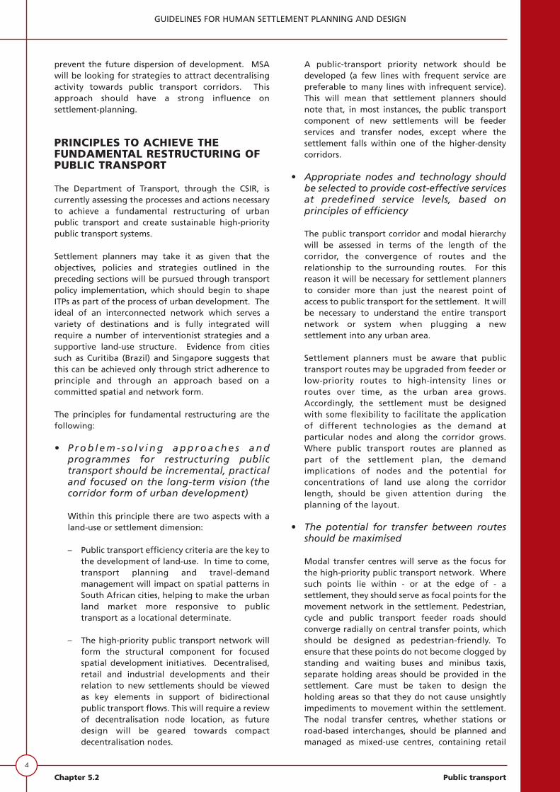
Settlement planners may take it as given that theobjectives, policies and strategies outlined in thepreceding sections will be pursued through transportpolicy implementation, which should begin to shapeITPs as part of the process of urban development. Theideal of an interconnected network which serves avariety of destinations and is fully integrated willrequire a number of interventionist strategies and asupportive land-use structure. Evidence from citiessuch as Curitiba (Brazil) and Singapore suggests thatthis can be achieved only through strict adherence toprinciple and through an approach based on acommitted spatial and network form.
The principles for fundamental restructuring are thefollowing:
• P r o b l e m - s o l v i n g a p p r o a c h e s a n dprogrammes for restructuring publictransport should be incremental, practicaland focused on the long-term vision (thecorridor form of urban development)
Within this principle there are two aspects with aland-use or settlement dimension:
– Public transport efficiency criteria are the key tothe development of land-use. In time to come,transport planning and travel-demandmanagement will impact on spatial patterns inSouth African cities, helping to make the urbanland market more responsive to publictransport as a locational determinate.
– The high-priority public transport network willform the structural component for focusedspatial development initiatives. Decentralised,retail and industrial developments and theirrelation to new settlements should be viewedas key elements in support of bidirectionalpublic transport flows. This will require a reviewof decentralisation node location, as futuredesign will be geared towards compactdecentralisation nodes.
A public-transport priority network should bedeveloped (a few lines with frequent service arepreferable to many lines with infrequent service).This will mean that settlement planners shouldnote that, in most instances, the public transportcomponent of new settlements will be feederservices and transfer nodes, except where thesettlement falls within one of the higher-densitycorridors.
• Appropriate nodes and technology shouldbe selected to provide cost-effective servicesat predefined service levels, based onprinciples of efficiency
The public transport corridor and modal hierarchywill be assessed in terms of the length of thecorridor, the convergence of routes and therelationship to the surrounding routes. For thisreason it will be necessary for settlement plannersto consider more than just the nearest point ofaccess to public transport for the settlement. It willbe necessary to understand the entire transportnetwork or system when plugging a newsettlement into any urban area.
Settlement planners must be aware that publictransport routes may be upgraded from feeder orlow-priority routes to high-intensity lines orroutes over time, as the urban area grows.Accordingly, the settlement must be designedwith some flexibility to facilitate the applicationof different technologies as the demand atparticular nodes and along the corridor grows.Where public transport routes are planned aspart of the settlement plan, the demandimplications of nodes and the potential forconcentrations of land use along the corridorlength, should be given attention during theplanning of the layout.
• The potential for transfer between routesshould be maximised
Modal transfer centres will serve as the focus forthe high-priority public transport network. Wheresuch points lie within - or at the edge of - asettlement, they should serve as focal points for themovement network in the settlement. Pedestrian,cycle and public transport feeder roads shouldconverge radially on central transfer points, whichshould be designed as pedestrian-friendly. Toensure that these points do not become clogged bystanding and waiting buses and minibus taxis,separate holding areas should be provided in thesettlement. Care must be taken to design theholding areas so that they do not cause unsightlyimpediments to movement within the settlement.The nodal transfer centres, whether stations orroad-based interchanges, should be planned andmanaged as mixed-use centres, containing retail
facilities, offices, community services, and evensome residential activities.
• Seamless services that contribute to theconcept of a centrally operated andcontrolled public transport system shouldbe developed
Seamless services have a uniform and shared fareand ticket system applied to all modes, andcustomers can transfer between travel modes witha minimum of delay and discomfort. This principlecan be supported by settlement planners if theyensure that a public-transport network, orpotential network, is provided which is direct andwhich is physically conducive to comfortable andconvenient transfer. In the design of the transportnetwork, every effort should be made to make theroute and facilities associated with it highly visibleand accessible to the community.
• Commercial, retail and industrialdevelopment activities should be located atappropriate nodes (convergence points onthe public transport network), preferablywithin the priority corridor structure
These spatial components of the fundamentalrestructuring of public transport are illustrated in
Figure 5.2.2, which highlights the principles thatshould be applied to achieve fundamentalrestructuring of public transport. Settlementplanners should be cognisant of the need forpublic transport nodes to be prioritised in terms oftheir location relative to the high-prioritynetwork, and should be based on meeting certainminimum thresholds of demand. A clearly definedapproach to settlement land-use planning isnecessary for the support of an efficient,structured public-transport system. Nodes whichfall short of the threshold of demand necessary tosupport a high-frequency public transport serviceshould have further development discouragedwithin them, both by zoning regulation and theuse of incentives and disincentives. This meansthat settlement planners need to understand atthe outset what the public transport thresholdsare, and should obtain this information byconsulting transport authorities about theirstandards for public transport in the vicinity.
Existing townships, particularly dormitorytownships, provide a special case in terms of nodalstructure. It is important that settlement plannerswho will be responsible for extensions of townshipsand infilling should understand that these types ofsettlement generally lack any kind of economic oractivity node. They are, however, powerful
5
GUIDELINES FOR HUMAN SETTLEMENT PLANNING AND DESIGN
Public transport Chapter 5.2
Fundamentalrestructuring
principles
Public transportnetwork supports
high-priorityhigh-frequency
services
Practical phasedprogrammes
focussed on along term vision
Commercial retailand industrialdevelopment
restricted to highpriority nodes of
corridors
High densityresidential
developmentencouraged withinhigh priority publictransport network
Public transportinvestment shouldpreempt land-use
change
Car travel andaccess are
restricted whereappropriate
Pricing of publicversus private
transport reflectspublic transport
priority
The road hierarchyand associated spatial
developmentsupports public
transport
Planning and managementphilosophy
Public transport priorityover
private car
Publictransport
supportivespatial
structure
Publictransportnetworkstructure
Hierarchicalnetwork structure
in support ofefficiencyprinciples
Integratedseamless networksupported by joint
fare structures
Maximised potentialfor inter-route
transfers
Figure 5.2.2: Principles to achieve the public transport supportive structure necessary for fundamentalrestructuring
Source: Shaw (1998)

6
GUIDELINES FOR HUMAN SETTLEMENT PLANNING AND DESIGN
Chapter 5.2 Public transport
generators of demand for public transport. For thisreason it is suggested that potential nodes4 beidentified within or immediately adjacent totownship areas. Under ideal circumstances,employment and amenity-related growth shouldbe located at these potential nodes. It must,however, be recognised that developers may beresistant to considering investing in such nodes,thereby constraining the ability to developefficient bidirectional ridership patterns. Thesettlement plan should make space available forthe relevant nodes to develop, even though theremay be resistance to invest at the outset.
• High-density residential developmentshould be encouraged within the priorityhigh-frequency public transport corridorstructure
Settlement planners need to understand thathigher-density residential development should beencouraged on unused or under-utilised landwithin the corridor structure of the high-prioritypublic transport network. While it is recognisedthat the current South African housing deliveryprocess does not encourage high-densitydevelopment, one of the most significant futurechallenges to settlement planners will be to finddelivery mechanisms and design solutions thatpromote higher-density residential development asa support mechanism for more efficient publictransport. This should apply particularly to theareas adjacent to high-frequency public transportcorridors and to nodes within all types of publictransport corridor.
• Public transport priority and infrastructureinvestment should pre-empt initiatives withrespect to land-use
In the urban areas of the future, as the primary andfeeder public transport route network is developedthere will be a need for flexibility in the networkwithin settlements to enable lesser traffic routes tobe upgraded as demand increases. This is not to saythat large reserves need to be set aside toaccommodate possible future public transport, butthat the internal circulation or movement systemshould be designed so that ultimately road-basedservices can be provided with stops at 800 to 1000 mintervals, with each of the stops having nodality andgood access to the surrounding settlement forpedestrians.
• The road hierarchy, and the associationbetween this hierarchy and spatialdevelopment, should support publictransport
Settlement planners should be cognisant of thenegative aspects of creating car-orientated“closed” road networks which are designed toinhibit through-traffic. Provision must be made forthe penetration of neighbourhoods by publictransport. The road hierarchy should promotedirect public transport routing and, wherenecessary, public transport priority, and encouragesuitable pedestrian access to surrounding land uses.Small residential cells may be designed as “closed”networks, providing that cycle and pedestrianthrough-movement is facilitated (for details seeSub-chapter 5.1).
In considering the public transport routes throughor adjacent to a settlement, settlement plannersare reminded to give consideration to the currentand proposed future function of the route,whether a primary public transport corridor or afeeder corridor. There is a need to separate theprimary public transport route from the private car-based arterial road network, and vice versa. Publictransport priority and a public transport supportiveroad hierarchy are essential to the success of thepromotion of high levels of service for publictransport. Unfortunately, attempts to give priorityto public transport over a considerable portion ofthe road network are unworkable because of theextensive coverage which would be needed. Itwould only be possible where there was reallysignificant demand for public transport. However,areas of the network offering the highestaccessibility need to be transferred from mixed-traffic conditions to dedicated rights-of-way forpublic transport.
If there is to be a priority node and/or corridorwithin a settlement, the planner should note theneed to make a distinction between the core andthe frame of the high-priority node. The coreshould be identified as the area of the greatestpedestrian activity. Parking should be omittedfrom the core in favour of dedicated pedestrianactivities. Parking facilities may be provided withinthe frame of a node.
One of the most significant components ofsettlement planning in support of public transportin the future will be decentralised nodes. Theplanners of new settlements need to ensure thatnodes with large commercial floor space should notbe provided in areas not served by public transport.
4 A potential node is a point in a public transport network where the public transport movement isconcentrated and transfers from one travel mode to another take place, providing conditions conducive forlocal economic development, based on the traffic at the node.

Thus a settlement unconnected to the primary orfeeder network through nodes should not bedeveloped as a decentralised activity centre.
• The pricing of public versus privatetransport should reflect public transportpriority
Settlement planners need to recognise that atargeted approach towards the management ofboth accessibility and the associated form of thepublic transport is needed. A key element in thefuture management of accessibility in buildingSouth African cities will be to move away from anapproach in which infrastructure improvements arecommissioned to relieve congestion, irrespective oflocation. In future, infrastructure improvementsshould be based on the enhancement ofaccessibility, particularly by public transport.
• Restrict car travel and access underappropriate circumstances
Settlement planners should restrict motor vehicleaccess within CBDs and other nodes. Along high-priority public transport routes the access ofpedestrians to fronting properties should bepromoted, whereas vehicle access should restricted.
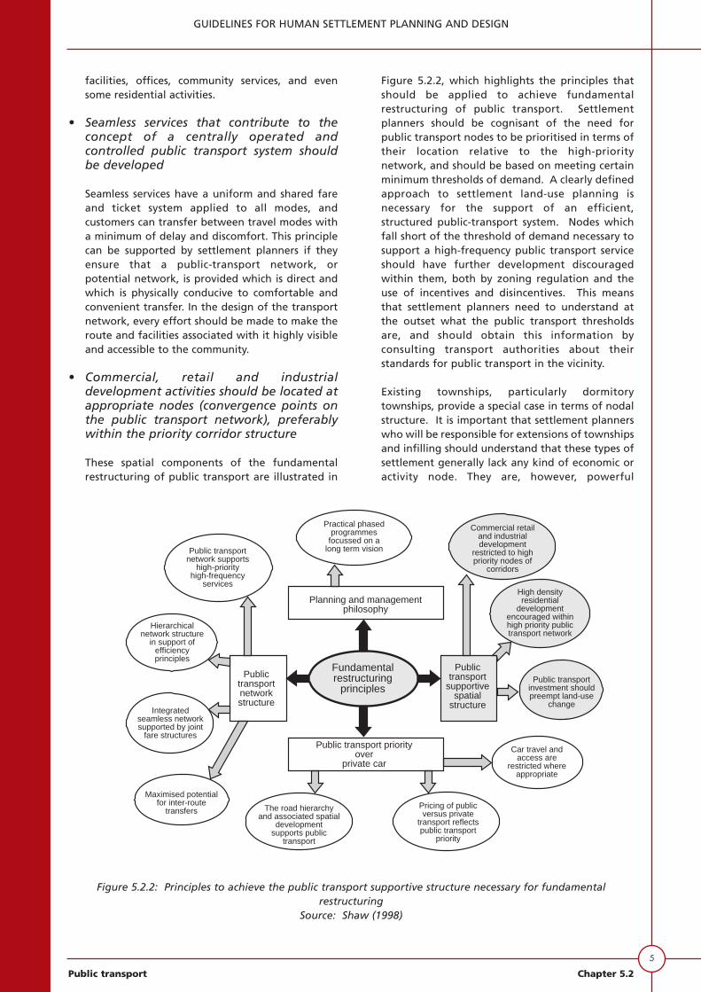
The Phase One report of the Department ofTransport’s fundamental restructuring projectcontains an assessment of four alternative cityforms with associated public transport networkstructures. The results, highlighted in Figure 5.2.3provide settlement planners with an overview ofthe impact of different city forms on passenger-volume conditions, average transfers per trip, tripsper capita and the directional mix of traffic.Settlement planners should, therefore, take painsto understand the network to which the settlementis to be attached.
PUBLIC TRANSPORT OBJECTIVES
The following objectives should be applied to giveeffect to the principles outlined in the precedingsection, and to ensure that the settlement is conduciveto the provision of efficient and convenient publictransport:
• providing for an urban structure of walkableneighbourhoods clustered together to form townsand cities of compatibly mixed uses, in order toreduce car dependence for access to activities;
• ensuring that walkable neighbourhoods and access
7
GUIDELINES FOR HUMAN SETTLEMENT PLANNING AND DESIGN
Public transport Chapter 5.2
Inbound
Outbound
Inbound
Outbound
Inbound
Outbound
Inbound
Outbound
Inbound
Outbound
Suburb CBD
Average transfers per trip
Not available
Ridership conditions
Moderate passenger turnover
Public transport trips per capita
London : 328
Theoretical ridership profile(morning peak):
Suburb CBD
Ridership conditions
High passenger turnover
Public transport trips per capita
Curitiba : 202
Theoretical ridership profile(morning peak):
Average transfers per trip
Curitiba : 1,4
Node Node
Ridership conditions
High/moderate passenger turnover
Public transport trips per capita
Stockholm : 322
Theoretical ridership profile(morning peak):
Average transfers per trip
Stockholm : 0,66
Suburb CBD
Theoretical ridership profile(morning peak):
Township CBD
Ridership conditionsLow passenger turnover
Public transport trips per capitaPretoria : 156
Average transfers per tripPretoria (Atteridgeville) : 0,23
Radial network concept
Example city:London, Paris
Arterial corridor andfeeder concept
Example city:Curitiba
Hub and spoke concept
Example city:Gothenburg, Stockholm
Dispersed radial concept
Example city:Pretoria
Example of four public transport network concepts
Figure 5.2.3: Example of four public transport network conceptsSource: Shaw (1998)

8
GUIDELINES FOR HUMAN SETTLEMENT PLANNING AND DESIGN
Chapter 5.2 Public transport
to services and facilities are designed for all users,including those with disabilities;
• facilitating development that supports theefficiency of public transport systems, with safe anddirect access; and
• providing a variety of plot sizes and housing typesto cater for the diverse housing needs of urbandwellers at densities that can support the provisionof viable public transport.
The design and layout of a settlement can have aprofound influence on its sustainability. A number ofobjectives need to be pursued which will contributetowards creating living environments that are moreaffordable for residents. The design should
• reduce dependence on cars by encouraging walking,cycling and the use of public transport; and
• give access to facilities for all users of theenvironment, and provide opportunities for locallybased business and employment.
As a global phenomenon, recent neighbourhooddesign concepts have been given titles such as “transit-oriented design” (TOD), “traditional neighbourhooddesign” (TND), “green-house neighbourhoods” and“urban villages”. In each case the underlying objectiveis to create neighbourhoods which reduce dependencyon private vehicles and are more energy-efficient.
GUIDELINES FOR PUBLIC TRANSPORTSUPPORTIVE SETTLEMENTS
Planning settlements that are accessibleto public transport
The process of planning for public transport includessite and contextual analysis, right down to the detailsof street alignment and form, plot sizes and shapes.The “coat-hanger” around which the settlementshould develop is the public transport network. Thisshould be supported by a movement network whichshould, as a priority, facilitate multi-directionalpedestrian movement, focused on a highly accessiblepublic transport system.
In respect of the public transport component ofsettlement-planning, the planning should takeaccount of and address the following questions:
• How big is the settlement, how will it be developedand at what density?
• Where is the settlement, relative to the mainactivities in the urban area in which it is situated?
• Where is the settlement located relative to existing
public transport, either rail- or road-based?
• How will the settlement be connected to theexisting public transport network, whether road orrail or both?
• Will the settlement be sufficiently large for themain public transport line-haul system to beextended through it, or will it be located to oneside of the major public transport route, or at somedistance from the corridor, requiring a feederpublic transport service?
• What will be the likely demand for public transportgenerated by the settlement?
• Where will the main access to public transport bewithin the settlement?
• What will be the spacing of public transport stopsin the settlement?
• How can the settlement be planned so that themovement system provides the maximum access topublic transport?
• What is the relationship between the movementsystem for the settlement and the proposed publictransport services?
Obviously, these and other questions will inform theplanner with regard to the integration of themovement and public transport networks. Specificguidelines on the site and contextual analysis, as theyrelate specifically to public transport, are provided inthe following section.
Contextualisation and connection
This should be undertaken at an early stage to identifyopportunities and constraints presented by the site.The processes take into account all constraints - such asopen space, topography and servitudes - and includean analysis of the regional structure andneighbourhood form in existing surrounding areas. Ofrelevance to the public transport planning is thefollowing:
On a map (as exemplified in Figure 5.2.4), and whererelevant, quantify the following information:
• existing and planned neighbourhoods, towns andregional centres;
• other significant features such as regional parks;
• freeways, arterial roads, public transport routes,bus stops and rail stations; and
• the location of rail stations.

Map, describe and where relevant, analyse, thefollowing information:
• servitudes and street reserves;
• linkage to and from the site;
• distance and direction to public transportinfrastructure; and
• distance and direction to local shops and schools.
The foregoing context and site analysis applies only topublic transport. Obviously there are other contextualand site-analysis factors which need to be taken intoaccount by settlement planners, including topography,drainage, vegetation, etc.
Figure 5.2.4 exemplifies the concepts ofcontextualisation and connection. It shows the siteand the spatial relationship between the site andexisting urban development, indicating the location ofthe main transport infrastructure, existing and futureroads and road reserves and future developments of
9
GUIDELINES FOR HUMAN SETTLEMENT PLANNING AND DESIGN
Public transport Chapter 5.2
Soshanguve
Existingsettlements
K2
Futureurban
settlement
PWV 9
Soshanguvestation
0 0,75 1,5km
Futureroad
reserve
Futurefreeway
Railway
K4
400m 400m
Klip-kruisfontein
Futureregional
park
Arterialroads
FutureCBD
Station
Road 2758
K63
800m
The site
Figure 5.2.4: Context and site analysis map

10
GUIDELINES FOR HUMAN SETTLEMENT PLANNING AND DESIGN
Chapter 5.2 Public transport
regional significance, such as a future CBD and railstation and a future regional park. This example issuperimposed on an actual settlement, but theelements (such as the proposed future regional park)are hypothetical. The figure illustrates some of thesite conditions that will influence the movement andpublic transport network. Topography and theinfluence of slope are not shown, but the planner iscautioned to note the importance of topography tothe public transport movement system (see Sub-chapter 5.1). It is obvious from this context and siteanalysis how the site needs to be developed to tie inwith the existing settlement and infrastructure. Thefreeway shown in the figure represents a constraint onthe development of the site. This constraint wouldrequire settlement planners to negotiate with roadand/or transport authorities, to provide measures toeliminate severance and to help minimise theenvironmental impact of the freeway on thedevelopment of the settlement. In this instance,settlement planners should persuade road authoritiesto provide freeway bridges or underpasses to link thecommunities on either side of the freeway. In thesituation depicted in the figure, the entire layout andsettlement plan will be influenced by the number andtype of movement connections which the roadauthority may be willing to provide. Differentcircumstances will prevail, and there may be caseswhere the local authority or transport authority willrequire the site developer to pay for providinglinkages. This decision usually hinges on the stage ofthe planning of the future freeway.
Public transport framework
Planning information requirements should address -but not be limited to - the following matters:
• the contents of the Integrated Transport Plan,including policy statements on the public transportnetwork, rail concessions, bus contracts, minibusinitiatives and public transport infrastructure;
• public transport demand (the origins anddestinations of trips) the placement of bus routes,proposed bus stop locations (including calculationsof walkable catchments served within a 400 metreradius);
• all existing/proposed rail station locations(including calculations of walkable catchmentsserved within an 800 m radius;
• provision for pedestrians and the disabled;
• an actual or potential cycle network plan;
• layouts to facilitate effective traffic managementaround schools and to facilitate safe access toschools;
• traffic management in and around proposedactivity centres;
• measures to control traffic speed; and
• proposed intersection controls, including prioritysystems signalled by the use of a clear movementhierarchy.
Guidance on the technique to use walkablecatchments as the basis for accessibility planning andcalculating catchments is listed in Appendix A.Examples of processes for restructuring publictransport demand for different settlement types andmarket segments are provided in Appendix B.
An example of the recommended process for thedevelopment of settlements supportive of publictransport is illustrated in Figure 5.2.5.
In consulting with transport authorities to ascertainfuture proposals in respect of road and railinfrastructure, as well as public transport services, theplanner is cautioned to note that, in some cases, thesettlement should influence and modify plannedtransport facilities. Some hard-nosed negotiation maybe necessary. A hypothetical public transportframework is illustrated in Figure 5.2.5.
It will be noted from Figure 5.2.5 that the main publictransport corridor is to be found to the west of thesettlement and comprises a commuter railway line,which provides for long distance movement, and a“road-based” activity spine within the corridor, toprovide for regional movement between stations andbetween different districts of the urban area. In thiscase, the location of the road-based activity spine maybe questioned because it duplicates and competeswith the rail service. An alternative location further tothe east and bisecting the settlement may bepreferable, to provide a viable threshold for the road-based public transport service. The regional, road-based “activity spine” needs to be well connected tothe rail at interchanges and stations. The figuredepicts a future station at the centre of a proposedfuture central business area. Such a station should beserved by feeder road-based public transport in whichcase there will be a need to plan for a public transport,interchange to facilitate this process. Although notpart of the settlement plan, the station and the publictransport interchange will exert a strong influenceover the road alignments in the settlement, asdepicted in the figure. The technique of using 800 mcatchments around stations, and 400 m catchmentsaround bus stops, has been used to provide thestructuring elements or transport framework for thesettlement. The figure shows the activity nodes in thecentre of the public transport catchments, which arethe focal points on the feeder routes and should bespaced at 800 m intervals. Such a design will providefor flexibility, even if feeder routes are not initially
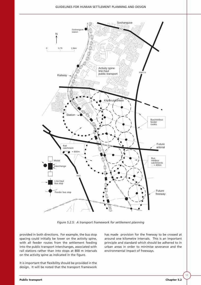
provided in both directions. For example, the bus stopspacing could initially be lower on the activity spine,with all feeder routes from the settlement feedinginto the public transport interchanges, associated withrail stations rather than into stops at 800 m intervalson the activity spine as indicated in the figure.
It is important that flexibility should be provided in thedesign. It will be noted that the transport framework
has made provision for the freeway to be crossed ataround one kilometre intervals. This is an importantprinciple and standard which should be adhered to inurban areas in order to minimise severance and theenvironmental impact of freeways.
11
GUIDELINES FOR HUMAN SETTLEMENT PLANNING AND DESIGN
Public transport Chapter 5.2
Futurefreeway
Klip-kruisfontein
Railway
Soshanguvestation
0 0,75 1,5km
Soshanguve
Activity spineline-haulpublic transport
Railcatchment
= 800m
Modal
Interchange
Line-haulbus stop
Feeder bus stop
Busminibuscatchments... = 400m
Bus/minibusfeederroutes
Futurearterial
K2
K63
PWV 9
Station
N
Figure 5.2.5: A transport framework for settlement planning
12
GUIDELINES FOR HUMAN SETTLEMENT PLANNING AND DESIGN
Chapter 5.2 Public transport
Integration of public transport andmovement networks
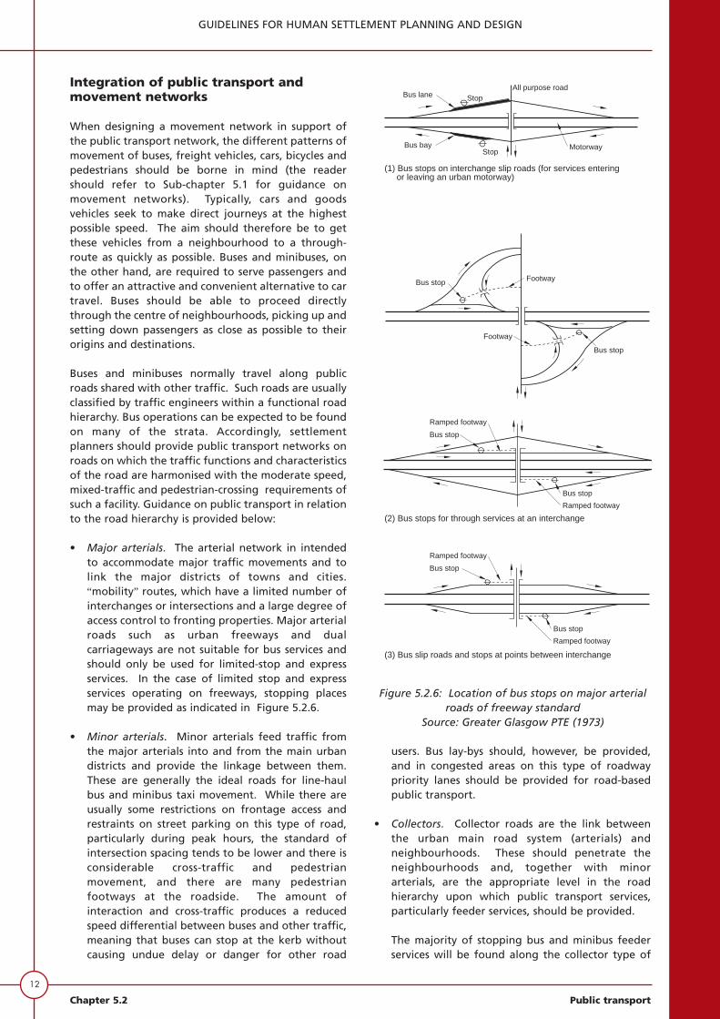
When designing a movement network in support ofthe public transport network, the different patterns ofmovement of buses, freight vehicles, cars, bicycles andpedestrians should be borne in mind (the readershould refer to Sub-chapter 5.1 for guidance onmovement networks). Typically, cars and goodsvehicles seek to make direct journeys at the highestpossible speed. The aim should therefore be to getthese vehicles from a neighbourhood to a through-route as quickly as possible. Buses and minibuses, onthe other hand, are required to serve passengers andto offer an attractive and convenient alternative to cartravel. Buses should be able to proceed directlythrough the centre of neighbourhoods, picking up andsetting down passengers as close as possible to theirorigins and destinations.
Buses and minibuses normally travel along publicroads shared with other traffic. Such roads are usuallyclassified by traffic engineers within a functional roadhierarchy. Bus operations can be expected to be foundon many of the strata. Accordingly, settlementplanners should provide public transport networks onroads on which the traffic functions and characteristicsof the road are harmonised with the moderate speed,mixed-traffic and pedestrian-crossing requirements ofsuch a facility. Guidance on public transport in relationto the road hierarchy is provided below:
• Major arterials. The arterial network in intendedto accommodate major traffic movements and tolink the major districts of towns and cities.“mobility” routes, which have a limited number ofinterchanges or intersections and a large degree ofaccess control to fronting properties. Major arterialroads such as urban freeways and dualcarriageways are not suitable for bus services andshould only be used for limited-stop and expressservices. In the case of limited stop and expressservices operating on freeways, stopping placesmay be provided as indicated in Figure 5.2.6.
• Minor arterials. Minor arterials feed traffic fromthe major arterials into and from the main urbandistricts and provide the linkage between them.These are generally the ideal roads for line-haulbus and minibus taxi movement. While there areusually some restrictions on frontage access andrestraints on street parking on this type of road,particularly during peak hours, the standard ofintersection spacing tends to be lower and there isconsiderable cross-traffic and pedestrianmovement, and there are many pedestrianfootways at the roadside. The amount ofinteraction and cross-traffic produces a reducedspeed differential between buses and other traffic,meaning that buses can stop at the kerb withoutcausing undue delay or danger for other road
users. Bus lay-bys should, however, be provided,and in congested areas on this type of roadwaypriority lanes should be provided for road-basedpublic transport.
• Collectors. Collector roads are the link betweenthe urban main road system (arterials) andneighbourhoods. These should penetrate theneighbourhoods and, together with minorarterials, are the appropriate level in the roadhierarchy upon which public transport services,particularly feeder services, should be provided.
The majority of stopping bus and minibus feederservices will be found along the collector type of
(3) Bus slip roads and stops at points between interchange
Ramped footway
Bus stop
Bus stop
Ramped footway
Bus lane Stop
Bus bayStop
All purpose road
Motorway
(1) Bus stops on interchange slip roads (for services entering or leaving an urban motorway)
Bus stop Footway
Bus stop
Footway
(2) Bus stops for through services at an interchange
Bus stop
Ramped footway
Ramped footway
Bus stop
Figure 5.2.6: Location of bus stops on major arterialroads of freeway standard
Source: Greater Glasgow PTE (1973)

road, which should preferably be at least 7,3 mwide. Widths in excess of this tend to encouragehigher speeds which are not desirable on mixed-traffic facilities.
• Activity streets. Hitherto, such streets have notformed part of the urban road hierarchy and havenot been planned, but have evolved. They arestreets that experience mixed traffic and intensefronting land use activity. Many activity streets startlife as high-mobility arterials but, because of theirhigh accessibility, become congested and attractcommercial land use. Access-seeking traffic beginsto predominate over through-traffic. Activity streetsare the ideal locus of road-based public transportservices. Settlement planners should provide layoutsand land-use plans which facilitate the emergenceof “activity streets” as the basis of public transportcorridors. The scale, geometric characteristics anddimensions of an “activity street” cannot bespecified prescriptively. An activity street could varyfrom collector-road scale, with a narrow cross-section, typical of a European village “high street” toa minor arterial in a generous cross-section. Typically,there should be interaction between one side of thestreet and the other, with much pedestrian crossing,so the scale of the street should be modest.
• Local (access) streets. Public transport should beprecluded from using this type of street, whichshould be designed to facilitate mixed trafficwithin neighbourhoods in safety and at low speed.
The specifics of the design and layout of the road andmovement networks are dealt with in section 5.1.
The following section provides some additionalguidelines in respect of the local road and movementnetworks in relation to public transport. Figure 5.2.7shows a public transport feeder route bisecting aneighbourhood unit with a radius of 400 m. The centre,or point of highest accessibility, is the point at whichpublic transport services will be provided. It is evidentfrom the layout that, because of the open road network,public transport is highly accessible along the publictransport route. The figure also indicates that, ideally,higher-density mixed land-use should be providedadjacent to the route. It also shows that service roadscan be provided for access to fronting shops.
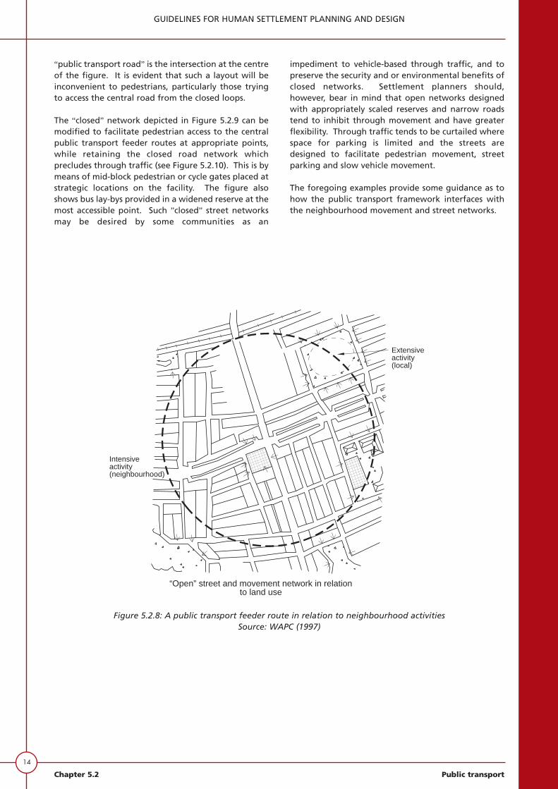
Figure 5.2.8 shows a variation of the same network toillustrate the point that intensive neighbourhoodactivity should be located at the centre or mostaccessible part of the neighbourhood, whereas moreextensive activity, some of which may have an inter-neighbourhood function, may be located further awayat the periphery, but will still be accessible on foot, toresidents in the neighbourhood. An example of thelatter is a primary school.
Figure 5.2.9 shows a “closed” street network which ischaracteristic of residential networks provided in therecent past. This type of network is a “car-orientednetwork” in that pedestrian movement is channelledalong the streets and the only access to the central
13
GUIDELINES FOR HUMAN SETTLEMENT PLANNING AND DESIGN
Public transport Chapter 5.2
Publictransportfeederroute
“Open” movement network with high density mixedland use in support of public transport
Figure 5.2.7: A public transport feeder route in an open networkSource: WAPC (1997)
14
GUIDELINES FOR HUMAN SETTLEMENT PLANNING AND DESIGN
Chapter 5.2 Public transport
“public transport road” is the intersection at the centreof the figure. It is evident that such a layout will beinconvenient to pedestrians, particularly those tryingto access the central road from the closed loops.
The “closed” network depicted in Figure 5.2.9 can bemodified to facilitate pedestrian access to the centralpublic transport feeder routes at appropriate points,while retaining the closed road network whichprecludes through traffic (see Figure 5.2.10). This is bymeans of mid-block pedestrian or cycle gates placed atstrategic locations on the facility. The figure alsoshows bus lay-bys provided in a widened reserve at themost accessible point. Such ”closed” street networksmay be desired by some communities as an
impediment to vehicle-based through traffic, and topreserve the security and or environmental benefits ofclosed networks. Settlement planners should,however, bear in mind that open networks designedwith appropriately scaled reserves and narrow roadstend to inhibit through movement and have greaterflexibility. Through traffic tends to be curtailed wherespace for parking is limited and the streets aredesigned to facilitate pedestrian movement, streetparking and slow vehicle movement.
The foregoing examples provide some guidance as tohow the public transport framework interfaces withthe neighbourhood movement and street networks.
Extensiveactivity(local)
Intensiveactivity(neighbourhood)
“Open” street and movement network in relationto land use
Figure 5.2.8: A public transport feeder route in relation to neighbourhood activitiesSource: WAPC (1997)

15
GUIDELINES FOR HUMAN SETTLEMENT PLANNING AND DESIGN
Public transport Chapter 5.2
Figure 5.2.10: Modification of a closed road network to provide an open movement network
Bus lay-by
Publictransport
feeder route
Pedestrian/cycle gate
“Closed” street network with “open” movementnetwork facilitating access to public transport
Figure 5.2.9: Car-oriented network
Car orientednetwork
“Closed” street network inconvenient forpedestrians and public transport

16
GUIDELINES FOR HUMAN SETTLEMENT PLANNING AND DESIGN
Chapter 5.2 Public transport
Integration of land use and publictransport
Land-use elements
To attract customers to public transport, plannersneed to understand the influence of land use andurban design on travel behaviour. As indicated inthe previous section, better integration of land useand public transport is possible when publictransport considerations are included in settlementplanning. Municipalities have the legal authorityand regulatory instruments to enforce urbandevelopment that is supportive of public transport.In terms of integrated development plans, it isimportant that development proposals should bereviewed in the light of traffic generation,potential public transport ridership, and ease ofoperation for public transport. This section of theguidelines describes what public transport-oriented land development means in terms ofurban structure, road networks and designstandards which are favourable to public transport.Changes to by-laws and regulations governing landdevelopment should be contemplated by allmunicipalities as part of their integrateddevelopment plans.
Figure 5.2.11 shows some typical land-useproposals which would be supportive of publictransport. At the centre of the public transportcatchments are cross-roads on the public transportnetwork. These roads may be mixed-traffic minorarterials and/or collector roads linked to thearterial road system. They are focused on accessibleactivity nodes at the centre of the neighbourhoods,based on a 400 m walking distance for residents.The activity nodes will largely attractneighbourhood retail and community facilities butwill also be the location of bus stops. The figurealso shows that, particularly on the most significantpublic transport route leading to the proposedfuture central business district, mixed high-densityland uses may be planned to support publictransport, and in some circumstances, tradingactivity may be encouraged. The figure shows howthe feeder routes converge on the major nodes.The central node should combine central placeactivity, retail, office and service functions, as wellas a modal interchange. It is evident that thecentral area should be highly accessible by road-based public transport.
It should be noted that the street network withinthe major public transport corridor is an existingstreet network, which may be incompatible withthe principles being propounded in this guideline.It is inevitable that, as major public transportcorridors evolve in urban areas, there may be aneed for redevelopment to encourage higherintensity land uses in support of the activity in the
corridor. Activity nodes are likely to develop ataccessible points in the corridor, as indicated in thefigure.
Factors contributing to viable andsustainable public transport
There has been extensive research to demonstratethat the features of public transport-friendly urbandesign include development density, the land-usemix, the configuration of the urban road networkand the design of movement or circulation systemswhich accommodate both pedestrians and publictransport vehicles. Throughout this guidereference has been made to settlement planners,but it is increasingly realised that urban settlementsshould be the product of multi-disciplinary workinvolving landscape architects, architects, urbanplanners and designers as well as traffic andtransport engineers. Greater effort is required todesign streets from a holistic perspective, asadvocated in this guideline, taking account of allforms of movement, including bicycles,pedestrians, cars, and public transport.
It is important to remember that the use of publictransport involves pedestrian movements at eitherend of the public transport trip. An unpleasantpedestrian experience will inhibit growth in publictransport patronage. Accordingly, very importantfactors in promoting public transport are perceivedproximity to the boarding point of publictransport, walking distance to the final destination,the overall street and site designs, pedestrianfacilities, and amenities on the sidewalks.
Development density
The two aspects of settlement density which areimportant to public transport are the location ofdense or less dense settlements, relative to publictransport services, and continuous density along apublic transport route.
In general, as residential and employment densitiesincrease, so do the number of passengers perkilometre along the route also increase, justifyingmore frequent or higher levels of public transportservice. This helps to make public transport muchmore attractive.
At metropolitan or city-wide scale, it is importantthat settlements should be continuous; that is, theyshould not be permitted to “leap-frog” agriculturalland or parkland, as was formerly the case with thelower-income dormitory settlements in SouthAfrica. Municipalities affected by discontinuousdevelopments will experience higher costs percapita for infrastructure such as roads and sewers.This will also apply to public transport services. Insettlement planning, the costs of new public

transport services should also be factored into theassessment of the municipal infrastructure requiredfor the settlement.
Relationship between density and thelocation of employment
Future settlement planning should take cognisanceof the need to develop balanced communitiescontaining employment activities within thecommunity. The settlement should seek to clusterbusinesses and employment activities into a few
areas of significant development, to help createthe critical mass which public transport requires toserve areas cost-effectively. Scattered travelpatterns should be avoided so that public transportreflects movement towards a single centre.Empirical research has found that public transportridership increases markedly when a threshold ofone employer per 100 m2, in a centre with morethan 10 000 jobs, is attained. Public transport istherefore heavily influenced by the critical mass ofemployees, but also by the availability of freeparking. Where parking is restricted, public
17
GUIDELINES FOR HUMAN SETTLEMENT PLANNING AND DESIGN
Public transport Chapter 5.2
Figure 5.2.11: Land-use elements in relation to the transport framework

18
GUIDELINES FOR HUMAN SETTLEMENT PLANNING AND DESIGN
Chapter 5.2 Public transport
transport ridership is also enhanced. One of themost serious impediments to the use of publictransport in urban areas is the decentralisedsuburban “business park”. Settlement plannersmust be cognisant of the detrimental effects ofsuch land uses on public transport, and ensure thatemployment is centred within public transportcorridors.
There are two factors that discourage the use ofpublic transport in office or business parks; namely,there is little incentive for employees to considerusing public transport when there is free parking,and office parks are usually located some distancefrom existing public transport services.
Relationship between public transport andresidential density
For public transport to be feasible a minimumthreshold population is necessary. However,because of the variety of residential marketsegments in South Africa and the relationshipbetween residential and employment activities, ithas not been easy to establish minimum thresholdsfor residential density. In lieu of clear thresholdsand guidelines it is advisable for settlementplanners to take note of relationships establishedabroad. For example, Table 5.2.1 shows publictransport services related to residential density as aresult of empirical studies in North America.According to Pushkarev and Zupan (1997) thedesired threshold for dwelling densities per hectareis around 10 for hourly local bus services, rising toaround 40 dwellings per hectare for very frequentpublic transport services at intervals of less than 10minutes.
Mixed land use and public transport
Mixing land uses means combining commercial andother uses of various types - for example
permitting personal services and restaurants to belocated near industry or commerce. Residentialsettlements should include convenient serviceswithin walking distance. The opportunity to walkto and from bus stops and accomplish errandsconveniently is a further motivation to use publictransport rather than to drive. The central or focalpoints within any neighbourhood which form partof a settlement should comprise the non-residential land uses such as convenience stores,retail shops, parks, schools and other amenities.The mix of land uses in close proximity to aneighbourhood centre will enable people toaccomplish several trip purposes, often by walking.Current zoning often requires strict land-usesegregation, resulting in large distances betweendifferent activities, increasing single-purpose trips.This can be discouraged by settlement plannerswho provide conditions conductive to the use ofpublic transport.
Providing for buses, minibuses and busstops
Alignment of public transport routes
Public transport routes should be planned to followa reasonably fast and direct itinerary passing asclose as possible to the centres of neighbourhoodsserved by the route. Circular routes should beavoided. Streets used as bus/minibus routes shouldhave a maximum gradient of 1 in 15 (6,7%). Wherewarranted by demand for public transport, parallelbus routes outside town centres should not be lessthan about 800 m apart, in order to provide eachroute with a reasonable catchment area.
Planning to facilitate bus services in newsettlements
Settlement planners should take intoconsideration the fact that areas of intense
Frequent Service (5-10 minute service intervals) 37
Frequent bus service with some express routes
(15 minute intervals) 22
Local bus (daytime 30 minute intervals and extended
services at 60 minute intervals) 17
Local bus (daytime 60 minutes intervals) 10
Table 5.2.1: The relationship between public transport services and residential density
TYPE OF PUBLIC TRANSPORT SERVICE GROSS RESIDENTIAL DENSITY (DWELLINGS/ha)
Source: Pushkarev and Zupan (1977)
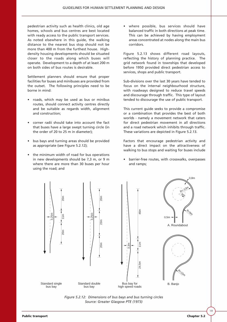
pedestrian activity such as health clinics, old agehomes, schools and bus centres are best locatedwith ready access to the public transport services.As noted elsewhere in this guide, the walkingdistance to the nearest bus stop should not bemore than 400 m from the furthest house. High-density housing developments should be situatedcloser to the roads along which buses willoperate. Development to a depth of at least 200 mon both sides of bus routes is desirable.
Settlement planners should ensure that properfacilities for buses and minibuses are provided fromthe outset. The following principles need to beborne in mind:
• roads, which may be used as bus or minibusroutes, should connect activity centres directlyand be suitable as regards width, alignmentand construction;
• corner radii should take into account the factthat buses have a large swept turning circle (inthe order of 20 to 25 m in diameter);
• bus bays and turning areas should be providedas appropriate (see Figure 5.2.12);
• the minimum width of road for bus operationsin new developments should be 7,3 m, or 9 mwhere there are more than 30 buses per hourusing the road; and
• where possible, bus services should havebalanced traffic in both directions at peak time.This can be achieved by having employmentareas concentrated at nodes along the main buscorridors.
Figure 5.2.13 shows different road layouts,reflecting the history of planning practice. Thegrid network found in townships that developedbefore 1950 provided direct pedestrian access toservices, shops and public transport.
Sub-divisions over the last 30 years have tended tofocus on the internal neighbourhood structure,with roadways designed to reduce travel speedsand discourage through traffic. This type of layouttended to discourage the use of public transport.
This current guide seeks to provide a compromiseor a combination that provides the best of bothworlds - namely a movement network that catersfor direct pedestrian movement in all directionsand a road network which inhibits through traffic.These variations are depicted in Figure 5.2.13.
Factors that encourage pedestrian activity andhave a direct impact on the attractiveness ofwalking to bus stops and waiting for buses include
• barrier-free routes, with crosswalks, overpassesand ramps;
19
GUIDELINES FOR HUMAN SETTLEMENT PLANNING AND DESIGN
Public transport Chapter 5.2
20m
3,25
m
20m
11m
24,5
m
0,8m
R= 13m
6m
R=9m
0,5m
R=15m
Standard singlebus bay
Standard doublebus bay
Bus bay forhigh speed roads
A. Roundabout
B. Banjo
20m
3,25
m
23m
20m
3,3m
46m
11m
Figure 5.2.12: Dimensions of bus bays and bus turning circlesSource: Greater Glasgow PTE (1973)

20
GUIDELINES FOR HUMAN SETTLEMENT PLANNING AND DESIGN
Chapter 5.2 Public transport
Figure 5.2.13: Road layouts reflecting evolvingplanning practice
Source: BC Transit (1995)
• good lighting and an environment which isperceived to be safe, because it is overlooked byhuman activity;
• sidewalks, seating and shelters; and
• pleasant views and other attractions, includinglandscaping and plantings.
The convenient location of bus stops is significant,and they should be placed relative to buildingentrances. This aspect is as important to publictransport customers as convenient parking is to carusers.
Modal choice and relative cost efficienciesfor infrastructure and operations
Although this subject is beyond the scope ofsettlement planners, they should be aware thatlayout of the movement network and the spatialarrangement of land uses can impact bothpositively and negatively on public transport.Where modal choice is a consideration, painsshould be taken to avoid duplication of publictransport infrastructure such as stops andterminals.
The relationship between public transportand commercial sites
Commercial sites in settlements which aresupportive of public transport usually face thestreet and provide easy access for customersapproaching by foot rather than by car.
Design features which encourage pedestrian flowinclude continuous sidewalks, trees and benches,and street furniture that provides a buffer betweencirculating traffic and the sidewalk. Figure 5.2.14shows the ideal relationship between a commercialactivity site and public transport.
Bus stops
The information that follows applies to both busesand minibuses. The location of bus stops must beplanned as part of the movement network at theoutset, to achieve the best arrangement. Thespacing of bus stops needs to be a compromisebetween the achievement of as high an operatingspeed for buses as possible and the placement ofstops within an acceptable walking distance oftraffic generators, attractors and transfer points.Bus-stop spacing depends on the density ofroadside development. Where development is notintense, such as in residential suburbs, stops shouldbe around 800 m apart. In nodal activity centreswhere there is a high concentration of trip ends,stops should be closer together, with an averageseparation of around 300 m. If there is more than
Bus route
Collector road
Arterial road
Loca
l roa
d
Bus route
Pedestrianpath
Busstop
Bus route

one bus service along a road, transfer is facilitatedif all the services use the same stop, providingcongestion is avoided.
Bus stops close to railway stations should bearranged to provide the minimum walking distancefor transferring passengers. At business centresstops should be sited so that buses depositpassengers at the main frontage of the centres.
For reasons of road safety, bus stops on oppositesides of a single two-way carriageway should bestaggered by a least 45 m, so that buses stop tail-to-tail. This dimension may be reduced where lay-bys are provided.
For the convenience of passengers, stops nearintersections or junctions should be located as closeas possible to the junction consistent with safety.Generally, bus stops should be located at the farside of the junction to minimise interference withleft-turning traffic and to maintain traffic-signalefficiency. If public transport is to be promoted,facilities should be provided at bus stops. Theseinclude shelters. In siting shelters, care must betaken to maintain adequate sight distance fordrivers emerging from side roads. Recommendedminimum distances are as follows:
CONCLUSION
If settlement planners are to succeed in providing anenvironment which is conductive to the use of publictransport, the greatest attention to detail should beprovided in respect of the development itself and itsrelationship with surrounding areas. The greatestattention should be provided for pedestrian amenity.Site design features that make public transport moreattractive are required but, given the pressures on theroad system, it is time to de-emphasise land-use designfor the convenience of car users, and refocus towardspedestrian movement and public transport. Publictransport-friendly designs can be achieved withoutdetrimental results for car users.
21
GUIDELINES FOR HUMAN SETTLEMENT PLANNING AND DESIGN
Public transport Chapter 5.2
Activitysite
in rearParking
siteActivity
P
P
Pedestrians prefer short distances fromeither automobiles or transit; and transit tripsare shorter when there is no route diversion
Transitroute
Figure 5.2.14: Relationship between bus stops and a commercial siteSource: BC Transit (1995)
50 23
65 31
80 38
SPEED LIMIT (km/h) MINIMUM DISTANCEAFTER LEFT TURN (m)

22
GUIDELINES FOR HUMAN SETTLEMENT PLANNING AND DESIGN
Chapter 5.2 Public transport
BIBLIOGRAPHY
Armstrong-Wright, A (1986) Urban transit systems:guidelines for examining options. World Bank TechnicalPaper No 52. The World Bank, Washington DC.
BC Transit (1995). Transit and land use planning.Surrey, British Columbia.
Behrens, R and Watson, V (1998). Movement networks.Urban Problems Research Unit, University of CapeTown.
Bernick, M and Cervero, R (1997). Transit Villages inthe 21st Century. McGraw-Hill, New York.
Calthorpe, P (1993). The next American metropolis:Ecology, community, and the American dream.Princeton Architectural Press, New York.
COLTO (Committee of Land Transport Officials (nd).Guidelines for the preparation of an integratedtransport plan TPG 1.
Department of the Environment and Transport (1994).Planning policy guideline: Transport PPG 13, HMSO,London.
Department of the Environment, Transport and theRegions (1998). Plans, streets and movement: Acompanion guide to Design Bulletin 32; Residentialroads and footpaths, HMSO, London.
FTA (1994). Planning for transit-friendly land use: Ahandbook for New Jersey communities. Federal TransitAdministration, US Department of Transportation.
Greater Glasgow PTE and Strathclyde Regional Council(1973). Guidelines for bus operation in urban areas,Glasgow.
IHT (forthcoming). Planning for public transport indevelopment. Institution of Highway andTransportation, London.
MCA Urban and Environmental Planners (1998).Planning and design of public transport systems.Unpublished report prepared for the CSIR. Cape Town.
Pushkarev, B S and Zupan, J M (1997). Publictransportation and land use policy, Indiana UniversityPress, Bloomington, Indiana.
PTRC (1991). Urban transport in developing countries.PTRC Education and Research Services, London.
Shaw, A (1998). Fundamental restructuring of theplanning management and operation of urban publictransport networks. Report No CR 98/018. Division ofRoads and Transport Technology, CSIR, Pretoria.
Simpson, B J (1994). Urban public transport today. E &FN Spon. London.
South Africa (1996). White Paper on NationalTransport Policy. Department of Transport.
South Africa, Department of Transport (1998). MovingSouth Africa: Towards a transport strategy for 2020,Pretoria.
TRC Africa (1999). Public Transport. Unpublishedreport prepared for the CSIR. Pretoria.
Tri-Met (1996). Planning and design for transithandbook: Guidelines for implementing transitsupportive development. Tri-County MetropolitanTransportation, District of Oregon, Portland.
TRL (1993). Public transport in third world cities, Stateof the Art Review/10. HMSO. London.
Westerman, H L (1996). The relationship between roadand land use planning. Austroads Project RSM 34,University of New South Wales, Sydney.
Western Australia Planing Commission (WAPC) (1997).Liveable neighbourhoods: community design code,Western Australian Planning Commission, Perth.

APPENDIX A
PUBLIC TRANSPORT CATCHMENTS AS THE BASIS FOR NEIGHBOURHOOD PLANNINGSource: Western Australian Planning Commission (1997)
Walkable catchments, when depicted on maps, show the actual area within a five minute walking distance fromany centre or bus stop, or ten minutes from any major transport interchange, such as a railway station. The centreshould ideally be an activity node for either a neighbourhood or a local community served by public transport. Thewalkable catchment helps in planning a settlement in such a way that it is easy to evaluate the ability to movethrough the urban area to access centres.
Walkable catchment calculations are expressed as the actual area within five minutes walking distance, as apercentage of the theoretical area within a five minute walking distance. The theoretical five minute walkingdistance is shown as a circle with a radius of about 400 metres around a focal points, such as a crossroad. Thisprovides an area of 50 hectares. When calculating a ten minute walking distance, the radius used is about 800metres, resulting in a circle with an area of 200 hectares (see diagram below). The higher the percentage of actualto theoretical five minute or ten minute walk, the better the “walkability”. A good target for a walkablecatchment is to have 60 per cent of the area within the stipulated walking distance.
Process for calculating walkable catchments.
1. On the settlement site map draw circles of 400 metre radius around desired focal points, and 800 metre radiuscircles around rail stations which are either existing or planned.
2. Starting from the centre, measure along the centre line of all planned streets to a distance of 400 metres.
3. Estimate the boundary of the plots within a 400 metre walk. This will provide the actual area from which thecentre can be accessed along the planned streets within a five minutes walk.
4. In the case of stations the same exercise may be completed for a ten minute walking distance using 800 metresas the distance measure. On each circle the result will be a map showing the actual distance within both thefive minute walk and the ten minute walk from rail stations.
5. Using a grid of scale hectares,calculate the approximate areaand hectares and the landaccessible within a five or tenminute walk and express this as apercentage of either the 50 or 200hectare circles. The percentagewill indicate the efficiency of thelayout.
Note that the walkable catchmentshould always count the area of landused for dwellings, but not includepublic open space contained in theaccessible area.
It should be noted that in fine-tuningthe calculations, there are practicalinfluences, such as short-cuts throughparks or along pedestrian paths.These should only be included wherethere is a high degree of surveillancefrom adjoining development andwhere there is good lighting.Similarly, the walkable catchmentmay need to be reduced where thereis poor surveillance and routes mayultimately be perceived as unsafe.
23
GUIDELINES FOR HUMAN SETTLEMENT PLANNING AND DESIGN
Public transport Chapter 5.2
N
24
GUIDELINES FOR HUMAN SETTLEMENT PLANNING AND DESIGN
Chapter 5.2 Public transport
APPENDIX B
GUIDELINES FOR ESTIMATING PUBLIC TRANSPORT DEMAND AND ASSOCIATED PUBLICTRANSPORT SYSTEMS IN SETTLEMENTSSource: South Africa, Department of Transport (1998)
The demand for public transport in any settlement is related to car ownership (affected by household incomes),the form of development (density, proximity to services, etc) and the quality of the services. Settlement plannersneed to understand public transport demand, in order to size facilities appropriately. In short, in planning asettlement, it is necessary to understand whether the public transport component is scaled to mini-bus taxis orbuses or trains. The following examples may be helpful. They are based on differing combinations of the 400metre radius of “walkable” neighbourhoods.
Conditions
1. A “walkable” public transport catchment of 400 m radius, encircling an area of 50 ha.
2. A “walkable” public transport catchment of 800 m radius for rail, encircling an area of 200 ha.
3. In the dwelling density range which is common in South Africa, of between 5 and 30 dwellings per hectare,around 60 per cent of a neighbourhood can be expected to be developed for residences. Thus in a 50 haneighbourhood the following may be expected:
plot sizes of 200 m2 = 30 du/ha = 1 500 unitsplot sizes of 600 m2 = 10 du/ha = 500 unitsplot sizes of 1 000 m2 = 6 du/ha = 300 units
4. Plot sizes usually approximate car ownership and household income, with the smaller plot sizes being associatedwith lower income and car ownership.
Assumptions
The following assumptions may be applied to public transport demand estimation for a low income settlementbased on parameters observed in Cape Town in the current “Moving Ahead” transport study:
1. Size of settlement = 50 ha (400 m walking radius).
2. Income of residents = < R40 000/household/year.
3. Non-residential development= 2 ha office/retail= 4 ha industrial= 4 ha schools and parks= 10 ha roads and public spaces.
4. Residential modal split = 85 per cent public transport.
5. Office and retail modal split = 60 per cent public transport.
6. Work trip generation rates for households earning < R40 000 per annum = 1,6 trips to work/day.
7. Average trip length = 14 km/trip.
8. Directional split = 70 per cent from neighbourhood to city centre; 30 per cent from neighbourhood to outernode.

Calculations
Public transport trip productions for a settlement of 30 du/ha (gross):
1. Total number of households = 10 000 m2 /ha x 0,6 = 1 500 du (200 m2 stands).
2. Commuter trip generation (TOTAL)Residential generation = 1,6 x 1 500 = 2 400Office/retail attraction = 2,0 x 250 = 500Industrial attraction = 4,0 x 100 = 400 .
3. Commuter trip generation (PUBLIC TRANSPORT)Residential generation = 2 400 x 0,85 = 2 040Non-residential = 900 x 0,6 = 540.
4. Total trips to work = 2 580.
Deductions
1. In the above example the demand for movement out of the settlement in peak work commuter periodsamounts to around 1 500 to 1 700 passenger trips (2 040 trips generated, with some having local and othersexternal destinations). There are 540 total neighbourhood trip attractions).
2. Around 1 600 peak period (x 3 hour) commuter trips would approximate a maximum peak hour demand ofabout 1000 trips per hour.
3. With a road-based public transport supply policy of 5 minute intervals for bus services in the peak, this wouldtranslate to a demand of about 12 buses per hour.
4. In a transport corridor comprising five such neighbourhoods on a single route, the capacity to meet suchdemand (5 000 passenger trips) would amount to 50 buses per hour.
5. In such conditions, a transport authority would need to consider higher capacity public transport options, eachof which would impact on traffic movement in the corridor. Such options might include:
• articulated buses;• bus priority and traffic management schemes; and• alternative transport nodes modes such as light or heavy rail.
6. In the foregoing circumstances the transport planning authority should be involved in planning the settlementto ensure that conditions on the ground facilitate effective public transport.
7. The above example represents an extreme case of a neighbourhood where residents would be heavilydependent upon public transport.
Forecast
It is not advisable for settlement planners to make long-term forecasts of demand for public transport. As a cross-check, however, the calculations outlined in this Appendix can be used as a consistency check to determine whencritical thresholds are likely to be reached in respect of public transport. At that stage, the necessary infrastructureadjustments can be made.
25
GUIDELINES FOR HUMAN SETTLEMENT PLANNING AND DESIGN
Public transport Chapter 5.2

26
GUIDELINES FOR HUMAN SETTLEMENT PLANNING AND DESIGN
Chapter 5.2 Public transport
APPENDIX C
THE MOVING SOUTH AFRICA (MSA) STRATEGY WITH REFERENCE TO LAND USE AND LANDMANAGEMENT ISSUESSource: South African, Department of Transport (1998)
Urban transport focuses on three categories of strategic action:
The first action is the densification of transport corridors. This requires the substantial reversal of apartheidland use planning to halt dispersion, but it is essential to achieve needed economies of scale in the transportsystem. The strategy will need an aggressive mix of controls and incentives, and will require appropriatelyintegrated coordination of the many institutions with a stake in the urban arena.
Land use patterns are the single greatest driver of the poor performance of the urban transport system in meetingcustomer needs, and so any solution will require either altering land tenure or working within its existing context.Distance, density, and employment location are all facets of land use that affect the layout of South African citiesand, subsequently, the economics and service levels of public transport.
Corridorisation lowers overall system costs - not only for transport but for other infrastructure, too - and alsoenables lower subsidies, raises travel speeds, and improves frequencies.
Today there is still a tendency towards continuing decentralisation, especially of workplace locations, which furthercomplicates the task of creating compact cities. Some degree of compact city may be achievable in some areas ofsome cities, and the MSA strategy does not rule out the option in some circumstances. However, the predominantpattern should be the corridor city. The corridor approach fits more easily with the existing South African urbanland tenure patterns. Its appropriateness is driven not only by the decentralised distant townships and the lowdensity inner-ring suburbs, but also by a recognition of the decline in CBD vitality and the dispersion ofdevelopment to satellite nodes. This pattern recognises the existing vacant land occupying the space between mosttownships and suburban areas, and also builds on existing flows along major current corridors.
Corridors already exist to some extent in South African cities. Therefore, the strategy focuses on densification ofexisting corridors and creation of new corridors for major new developments. It is essential to prevent the furtherdispersion of development, and to create incentives for any decentralisation away from the CBD to occur withinthe corridor context. The major trade-off against the corridor densification strategy is the higher cost of land fornew housing projects closer to the CBD. Analysis shows that transport and other utilities generate savings over timewhich compensate for the increased cost of land.
Housing targets are driving the need to build on cheap, available land, which is causing dispersion. Transport andother utilities have to be provided to serve these dispersed housing developments, bearing increased long-termcosts.
Because of the uniquely local nature of land use decisions, the most challenging part of implementing the corridorvision will be the co-ordination across and within government to overcome the obstacles. Some national policies,as in housing, encourage continued dispersion, based on the economics of land acquisition. These policies will needto be harmonised to fit into a paradigm that encompasses the systems cost of all community infrastructure, not justone component like housing or electricity.
The MSA strategy recognises many other obstacles exist to corridor densification, and overcoming these potentialpitfalls will require strong co-operation across government. In particular four different public entities will need toact in close co-operation and co-ordination:
• National Government must provide the overall strategic vision for urban development, including transport. Itmust also create a framework for absorbing systems costs and aligning the incentives for different nationaldepartments to follow the framework. Out of this activity will come guidelines for internalising systems costswithin land developments.
• Provincial Government must create broad provincial land use strategies that account for full systems cost, withinthe context of the national government framework. In addition, they will need to orient the subsidy policy tosupport the corridors, and are responsible for urban roads.

• The Roads Agency will need to align investments in national roads in urban areas with the local corridorstrategies developed by local entities.
• Local Government and Metropolitan Transport Authorities will be responsible for developing land use andtransport plans, and will now need to be integrated into planning for major commercial and residentialdevelopments. The subsidy allocation procedure must be linked into the corridor densification strategy.
The second action works to optimise modal economics and the service mix. Investment in corridors isprimarily roads-based, because densities of new corridors are unlikely to support new rail lines. The strategy is oneof regulated competition, with integration of modes facilitated. Optimising modal economics requires addressingthe use of road space, and the strategy proposes tough road space management to prioritise public transport. Aprincipal lever of the recommended strategy is that of subsidies, which will be targeted and providing affordableaccess to the stranded and subsidising the most economic mode on each corridor.
The third strategic action entails improving firm-level performance, a task which predominantly fallsto private firms. The strategy requires effective regulation of all modes, especially minibus-taxis and theenforcement thereof. It emphasises tendering for subsidised routes and other forms of contract management, withbuilt-in incentives for productivity innovation and reinvestment.
Implementing the strategy will require overcoming some significant obstacles. Changing the nature of land-useplanning, road space management, planning and regulation, and subsidy targeting will need agreement on theobjectives and strong political will.
27
GUIDELINES FOR HUMAN SETTLEMENT PLANNING AND DESIGN
Public transport Chapter 5.2

28
GUIDELINES FOR HUMAN SETTLEMENT PLANNING AND DESIGN
Chapter 5.2 Public transport


