Chapter 5 Prehistoric Archaeological Resources ...dot.ca.gov/ser/vol2/ch5.pdf · 2/1/2015 ·...
67
2014 Update rev: 01/02/15 Page 5:i Volume 2 -Standard Environmental Reference Copyright ©2014 California Department of Transportation. All rights reserved. Chapter 5: Prehistoric Archaeological Resources Identification, Evaluation and Treatment TABLE OF CONTENTS 5.1 Introduction .....................................................................................................................1 5.2 Laws and Regulations .....................................................................................................1 5.3 Standards, Work and Safety............................................................................................2 5.3.1 Professional Qualifications .......................................................................................2 5.3.2 Standards for Documents ..........................................................................................3 5.3.3 Confidentiality of Information ..................................................................................4 5.3.4 Typical Hours and Elapsed Time for Studies ...........................................................5 5.3.5 CSO Assistance with Studies ....................................................................................5 5.3.6 Field Safety ...............................................................................................................5 5.4 Identifying Prehistoric Sites (Phase I) ............................................................................6 5.4.1 Pre-field Preparations................................................................................................6 5.4.2 Archaeological Field Survey.....................................................................................8 5.4.3 Properties Exempt from Evaluation ........................................................................10 5.4.4 Recording Archaeological Sites..............................................................................12 5.4.5 Archaeological Reporting .......................................................................................14 5.4.6 Review, Approval, and Distribution of ASR ..........................................................16 5.5 Extended Phase I for Prehistoric Sites ..........................................................................17 5.5.1 Extended Phase I Proposal ......................................................................................18 5.5.2 Review, Approval, and Distribution of XPI Proposal ............................................19 5.5.3 Pre-field Preparations..............................................................................................20 5.5.4 Fieldwork, Laboratory Analysis, and Curation.......................................................21 5.5.5 Extended Phase I Report .........................................................................................22 5.5.6 Review, Approval, and Distribution of XPI Report ...............................................22 5.6 Evaluating Prehistoric Sites (Phase II) .........................................................................23 5.6.1 Assumption of Eligibility and Use of ESAs under the Section 106 PA........................................................................................................26
Transcript of Chapter 5 Prehistoric Archaeological Resources ...dot.ca.gov/ser/vol2/ch5.pdf · 2/1/2015 ·...

2014 Update rev: 01/02/15 Page 5:i Volume 2 -Standard Environmental Reference
Copyright ©2014 California Department of Transportation. All rights reserved.
Chapter 5: Prehistoric Archaeological Resources Identification, Evaluation and Treatment
TABLE OF CONTENTS
5.1 Introduction ..................................................................................................................... 1
5.2 Laws and Regulations ..................................................................................................... 1
5.3 Standards, Work and Safety ............................................................................................ 2
5.3.1 Professional Qualifications ....................................................................................... 2
5.3.2 Standards for Documents .......................................................................................... 3
5.3.3 Confidentiality of Information .................................................................................. 4
5.3.4 Typical Hours and Elapsed Time for Studies ........................................................... 5
5.3.5 CSO Assistance with Studies .................................................................................... 5
5.3.6 Field Safety ............................................................................................................... 5
5.4 Identifying Prehistoric Sites (Phase I) ............................................................................ 6
5.4.1 Pre-field Preparations................................................................................................ 6
5.4.2 Archaeological Field Survey ..................................................................................... 8
5.4.3 Properties Exempt from Evaluation ........................................................................ 10
5.4.4 Recording Archaeological Sites .............................................................................. 12
5.4.5 Archaeological Reporting ....................................................................................... 14
5.4.6 Review, Approval, and Distribution of ASR .......................................................... 16
5.5 Extended Phase I for Prehistoric Sites .......................................................................... 17
5.5.1 Extended Phase I Proposal ...................................................................................... 18
5.5.2 Review, Approval, and Distribution of XPI Proposal ............................................ 19
5.5.3 Pre-field Preparations.............................................................................................. 20
5.5.4 Fieldwork, Laboratory Analysis, and Curation....................................................... 21
5.5.5 Extended Phase I Report ......................................................................................... 22
5.5.6 Review, Approval, and Distribution of XPI Report ............................................... 22
5.6 Evaluating Prehistoric Sites (Phase II) ......................................................................... 23
5.6.1 Assumption of Eligibility and Use of ESAs under the Section 106 PA........................................................................................................ 26
Chapter 5: Prehistoric Archaeological Resources Identification, Evaluation and Treatment
2014 Update rev: 01/02/15 Page 5:ii Volume 2 -Standard Environmental Reference
Copyright ©2014 California Department of Transportation. All rights reserved.
5.6.2 Evaluation without Excavation ............................................................................... 28
5.6.3 Using Programmatic Treatments / CARIDAPS ..................................................... 29
5.6.4 Archaeological Evaluation Proposal (AEP)............................................................ 30
5.6.5 Review and Distribution of AEP ............................................................................ 30
5.6.6 Pre-field Preparations.............................................................................................. 31
5.6.7 Fieldwork, Laboratory Analysis, and Curation....................................................... 33
5.6.8 Archaeological Evaluation Report .......................................................................... 33
5.6.9 Review, Approval, and Distribution AER .............................................................. 34
5.7 Environmentally Sensitive Areas .................................................................................. 36
5.7.1 Providing ESA Information to Others .................................................................... 36
5.7.2 Enforcement of ESAs ............................................................................................. 36
5.7.3 Posting of Archaeological ESAs ............................................................................. 37
5.8 Archaeological Data Recovery (Phase III) ................................................................... 38
5.8.1 Data Recovery Plan................................................................................................. 40
5.8.2 Headquarters Review of Mitigation Measures Costing $500,000 and Above .............................................................................................................. 41
5.8.3 Review, Approval, and Distribution of DRP .......................................................... 41
5.8.4 Phase III Proposal ................................................................................................... 43
5.8.5 Review, Approval, and Distribution of Phase III Proposal .................................... 43
5.8.6 Fieldwork, Laboratory Analysis, and Curation....................................................... 45
5.8.7 Data Recovery Report ............................................................................................. 45
5.8.8 Review, Approval, and Distribution of Data Recovery Report ...................................................................................................................... 46
5.8.9 Other Data Recovery Commitments ....................................................................... 47
5.9 Coordinating Consultant Studies .................................................................................. 47
5.10 Construction Monitoring and Post-Review Discoveries............................................... 48
5.10.1 Effective Monitoring ............................................................................................... 48
5.10.2 Planning for Post review Discovery ....................................................................... 48
5.10.3 Post-Review Discovery – No Plan in Place ............................................................ 49
5.10.4 Safety Concerns While Monitoring ........................................................................ 49
5.10.5 Recovery of Artifacts During Construction ............................................................ 49
5.11 Archaeological Study Permits....................................................................................... 50

Chapter 5: Prehistoric Archaeological Resources Identification, Evaluation and Treatment
2014 Update rev: 01/02/15 Page 5:iii Volume 2 -Standard Environmental Reference
Copyright ©2014 California Department of Transportation. All rights reserved.
5.11.1 Federal Permit Legislation ...................................................................................... 51
5.11.2 California Permit Legislation .................................................................................. 55
5.12 Archaeological Studies: Preconstruction, Maintenance, Excess Property Disposal, and Encroachment Permits ........................................... 57
5.12.1 Preconstruction Studies ........................................................................................... 57
5.12.2 Maintenance Projects .............................................................................................. 58
5.12.3 Excess Property Disposal ........................................................................................ 58
5.12.4 Encroachment Permits ............................................................................................ 59
5.13 Peer Review and Approval of Archaeological Documents .......................................... 60
5.13.1 Peer Review ............................................................................................................ 61
5.13.2 Caltrans Review and Approval of Archaeological Documents .............................................................................................................. 62
5.13.3 Report Distribution ................................................................................................. 62
5.14 State-Owned Archaeological Resources ....................................................................... 62


2014 Update rev: 01/02/15 Page 5:1 Volume 2 -Standard Environmental Reference
Copyright ©2014 California Department of Transportation. All rights reserved.
Chapter 5: Prehistoric Archaeological Resources Identification, Evaluation, and Treatment 5.1 Introduction
At least 12,000 years of human occupation are represented in California's prehistoric archaeological sites. These resources form an irreplaceable source of knowledge of the prehistoric events, peoples, and lifeways of the region. Increasingly, however, growth and development have threatened the existence of that archaeological record which, once lost, can never be restored. By enacting a body of law and by providing regulations and guidelines, both the federal and state governments have taken steps to protect those non-renewable resources.
Caltrans cultural resource policy is to avoid and, if avoidance is not possible, to min-imize adverse effects of transportation projects upon significant cultural resources. This chapter, which a part of the Caltrans Standard Environmental Reference Volume 2-Cultural Resources (SERv2), provides information on the procedures and docu-ments used to implement this policy and to comply with state and federal laws and regulations, with respect to prehistoric archaeological resources; see Chapter 6 for guidance on historical archaeological resources.
5.2 Laws and Regulations Caltrans prepares cultural resources studies to comply with the California Environ-mental Quality Act of 1970 (CEQA) and Section 106 of the National Historic Preser-vation Act (NHPA) of 1966, as amended (16 USC 470). Chapter 2 discusses the gen-eral regulatory context of this work. Chapter 3 discusses laws relating to the in-volvement of Native American Tribes, groups or individuals in cultural resource stud-ies, including curation and compliance with Health and Safety Code and Public Re-sources Code when dealing with human remains and associated grave goods.
State and federal laws restrict the release of specific archaeological site location in-formation to the public; see Section 5.3.3 below.

Chapter 5: Prehistoric Archaeological Resources Identification, Evaluation and Treatment
2014 Update rev: 01/02/15 Page 5:2 Volume 2 -Standard Environmental Reference
Copyright ©2014 California Department of Transportation. All rights reserved.
5.3 Standards, Work and Safety
5.3.1 Professional Qualifications Caltrans selects cultural resources specialists based on standards set by the California State Personnel Board and the federal Secretary of the Interior’s Professional Quali-fications Standards. While these different standards overlap in many regards, they are not identical. Taking into consideration these different sets of standards in rela-tion to Caltrans cultural resources needs, Caltrans has identified six levels of archaeo-logical qualifications for Caltrans cultural resources staff. These six levels are codi-fied as Professionally Qualified Staff (PQS) levels in the Section 106 Programmatic Agreement (Section 106 PA Attachment 1) and Public Resources Code 5024 Memo-randum of Understanding (5024 MOU Attachment 1), and have been adopted as the new qualifications standards for both federal undertakings and state-only (Section 106 and CEQA-level) Caltrans cultural resources activities. These qualifications levels are as follows:
• Archaeological Crew Member • Lead Archaeological Surveyor • Co-Principal Investigator, Prehistoric Archaeology • Co-Principal Investigator, Historical Archaeology • Principal Investigator, Prehistoric Archaeology • Principal Investigator, Historical Archaeology
These levels and associated criteria are specific to Caltrans, and may or may not correspond with similar titles and qualifications in other agencies and organizations.
The six qualifications levels reflect increasing levels of expertise, as demonstrated by education, experience, understanding of the Section 106 process, and familiarity with Caltrans’ cultural resource policies, procedures, and goals. Use of these qualifica-tions levels is designed to provide a credible and competent staff, and to ensure that Caltrans staff meets the standards of the federal agencies that review Caltrans’ work. All Caltrans archaeological work must be performed by and/or, directed and re-viewed, by Professionally Qualified Staff, or PQS (i.e., staff meeting the qualifica-tions for the designated level of work). More specifically, those not fully qualified as archaeological Principal Investigators may perform many tasks with Principal Inves-tigator oversight (generally in the form of peer review) or under direct supervision Principal Investigator(s) in the appropriate discipline.

Chapter 5: Prehistoric Archaeological Resources Identification, Evaluation and Treatment
2014 Update rev: 01/02/15 Page 5:3 Volume 2 -Standard Environmental Reference
Copyright ©2014 California Department of Transportation. All rights reserved.
The Section 106 PA Attachment 1/5024 MOU Attachment 1 lists the criteria to meet these different qualification levels. Caltrans archaeological staff are certified as to level of expertise by submitting a completed copy of the relevant PQS certification form to the Headquarters’ Cultural Studies Office (CSO) of the Division of Environ-mental Analysis (DEA) for evaluation by the CSO Chief. (See Chapter 1 beginning with Section 1.3.5 for a complete discussion on the subject of qualifications and Section 1.3.6 for the Caltrans PQS certification process). Exhibit 1.6 Table 2 pro-vides a chart of PQS levels required for roles in archaeological studies.
Caltrans also uses the same professional qualifications standards in fulfilling its cul-tural resources compliance for prehistoric archaeology under CEQA.
5.3.1.1 Caltrans staff archaeologists In addition to preparing technical studies, under the Section 106 PA/5024 MOU Cal-trans staff archaeologists who are certified as PQS also review and approve Section 106 documents. District or CSO PQS also may review consultants’ resumés to ensure professionals meeting the Secretary of the Interior’s Professional Qualifications Standards conduct work.
The PQS delegation applies to Caltrans staff only.
5.3.1.2 Consultant archaeologists Consultants working on FHWA-funded undertakings and Caltrans state-only projects must meet the Secretary of the Interior’s Professional Qualifications Standards. While professional archaeologists outside of Caltrans who meet the Secretary of the Interior’s Professional Qualifications Standards may prepare work for submittal un-der the Section 106 PA/5024 MOU, they are not certified as PQS. The Caltrans PQS is responsible for the review, approval and submittal of consultant-prepared docu-ments to CSO1 and the State Historic Preservation Officer (SHPO) or Tribal Historic Preservation Officer (THPO) under the Section 106 PA/5024 MOU.
5.3.2 Standards for Documents Later sections of this chapter discuss the standards for completing and evaluating var-ious Caltrans archaeological studies and documents. These standards are based pri-marily on the standards set forth at 36 CFR 800.11, but also rely on guidance in the Secretary of Interior's Standards and Guidelines for Archeology and Historic Preser-
1 To FHWA for projects on tribal lands or for which FHWA has retained Section 106 responsibilities
(“non-assigned” project), with a copy to CSO.

Chapter 5: Prehistoric Archaeological Resources Identification, Evaluation and Treatment
2014 Update rev: 01/02/15 Page 5:4 Volume 2 -Standard Environmental Reference
Copyright ©2014 California Department of Transportation. All rights reserved.
vation, and the California Office of Historic Preservation (OHP) publications Ar-chaeological Resource Management Reports (ARMR): Recommended Contents and Format (DPR 1989) and Guidelines for Archaeological Research Designs (DPR 1991) and in National Register Bulletins 36 and 38.
5.3.3 Confidentiality of Information Consistent with the requirements of NHPA Section 304, the Federal Highway Admin-istration (FHWA), and Caltrans, as assigned by FHWA, may withhold from disclo-sure to the public all information relating to the location or character of historic prop-erties whenever they determine that disclosure may create a substantial risk of harm to the resource.
Information on archaeological site locations is also exempt from public access, as provided by the California Public Records Act (California Government Code 6254.10). In addition, effective beginning in 2015, PRC 21082.3(c) provides confi-dentiality protections for information California tribes have provided through consul-tation.
Information on the specific locations of archaeological sites is made available only on a “need-to-know” basis to individuals who legitimately need this information to meet their project responsibilities. This may include Caltrans environmental branch chiefs and generalists, project managers and engineers, archaeological consultants, and Na-tive American Tribes, groups or individuals.
As a general rule, archaeological site records, maps, and aerials depicting exact site locations are limited to technical documents, such as archaeological survey and exca-vation reports. These documents are not available to the general public, but qualified researchers may consult them at the District Environmental Branch (DEB), CSO, and the Information Centers of the California Historical Resources Information System (CHRIS). The Information Centers require all researchers who use the records to sign an Agreement of Confidentiality form which states that they will not disclose specific site locations to unauthorized individuals or in publicly distributed documents without written consent of the State Historic Preservation Officer (SHPO).
While management documents contain legal findings under Section 106, such as in the Historic Property Survey Reports (HPSR), and under CEQA and PRC 5024 in the Historical Resources Compliance Report (HRCR), information may need to be ex-tracted from technical documents; such documents are to exclude sensitive materials.

Chapter 5: Prehistoric Archaeological Resources Identification, Evaluation and Treatment
2014 Update rev: 01/02/15 Page 5:5 Volume 2 -Standard Environmental Reference
Copyright ©2014 California Department of Transportation. All rights reserved.
Technical documents containing confidential information should not be appended to copies of HPSRs or HRCRs that may circulate outside the path of CSO2/SHPO/THPO review. Documents attached to copies in that path must be la-beled as confidential.
5.3.4 Typical Hours and Elapsed Time for Studies The amount of staff work and schedule time required to complete the different types of archaeological studies vary greatly, depending on a range of potentially important factors:
• Size of the project • Number and complexity of the sites involved • Changes in project schedules or design • Delays in ancillary studies • Conflicting workload priorities
Caltrans has made several analyses of projects to provide rough estimates for work and schedule requirements. Exhibit 2.3 summarizes these estimates which can range from one month for a survey report to as much as five years for a project requiring data recovery excavations.
5.3.5 CSO Assistance with Studies The CSO provides archaeological assistance to the Caltrans districts on more com-plex undertakings. While CSO is not available to prepare technical reports, experts can provide guidance on all aspects of Section 106 compliance and documentation. To request such assistance, send an email or memo to the CSO Chief.
5.3.6 Field Safety Caltrans's policy is that "no field activity shall be considered so important or urgent that…any safe practice will be compromised." The lead archaeologist on a field crew is responsible for ensuring that the crew is aware of safety hazards, concerns, and precautions. Chapter 4 Section 4.6.3.4 provides more information on field safety.
Caltrans strongly recommends using the “buddy system” anytime staff are in the field. For work in remote or dangerous localities and in hazardous areas or condi-tions, safety procedures include the "buddy system" on surveys and daily communi-cation with a supervisor.
2 And FHWA for non-assigned project or those on tribal lands.

Chapter 5: Prehistoric Archaeological Resources Identification, Evaluation and Treatment
2014 Update rev: 01/02/15 Page 5:6 Volume 2 -Standard Environmental Reference
Copyright ©2014 California Department of Transportation. All rights reserved.
Where applicable, staff should be certified in Hazardous Waste Operations and Emergency Response (40-HAZWOPER) safety training, confined space procedures, and shoring procedures. For excavations deeper than 150 cm (5 ft.), shoring, or ac-ceptable alternatives to shoring, in conformity with the Division of Occupational Safety and Health (OSHA) standards, must be used. The principal investigator on excavations can also request a safety review by the Caltrans District Safety Officer.
Additional information on safety practices can be found in:
• Caltrans Safety Manual, Chapter 5 sections 5.08 and 5.13 and the Code of Safe Practices for Field Trips (Appendix A)
• Caltrans Construction Manual, Chapter 2, sections on Safety and Traffic. • Caltrans Surveys Manual, Chapter 2 (Safety) and the Caltrans Code of Safe Sur-
veying Practices
5.4 Identifying Prehistoric Sites (Phase I) The identification phase for archaeological studies typically involves conducting a records search, continuing consultation with Native Americans, conducting an ar-chaeological field survey of the project Area of Potential Effects (APE), and docu-menting the results of the survey (both prehistoric and historical archaeological prop-erties) in an Archaeological Survey Report (ASR), discussed in Chapter 5 Section 5.4.5.
5.4.1 Pre-field Preparations Preparations for archaeological surveys include:
• Defining the APE or Study Area on project mapping • Researching appropriate records and literature • Identifying Native American concerns • Securing the required permits for the survey from public agencies and private
landowners • Scheduling the survey and making physical arrangements (coordinated with dis-
trict Right-of-way)
The archaeological survey area is based on the project APE, set by the Project Man-ager and the Caltrans PQS, see Chapter 4 Section 4.3. If the APE has not been set by the time an archaeological survey is needed, then a Study Area will be designated un-til an APE can be delineated. The APE for archaeology is referred to as the Direct APE or Area of Direct Impact (ADI). It usually includes the existing right-of-way;

Chapter 5: Prehistoric Archaeological Resources Identification, Evaluation and Treatment
2014 Update rev: 01/02/15 Page 5:7 Volume 2 -Standard Environmental Reference
Copyright ©2014 California Department of Transportation. All rights reserved.
any new right-of-way; all proposed easements, temporary or permanent, including staging areas or construction access roads; and material or disposal sites that may be impacted by project activities.
The project map, either a contour map or an aerial photograph, should have the pro-ject APE or Study Area delineated on it by Caltrans district personnel in consultation with the Project Manager. Depending on the complexity of the project, all major cul-tural features and all facets of the proposed project (e.g., cut/fill lines, drainage struc-tures, new right-of-way, borrow sites, haul roads) should be depicted on the map.
The map should be of a scale (at least 1” = 200’) suitable to serve as a base map for the report.
Accurate maps or aerial photographs allow the archaeologist to plan the archaeologi-cal field survey, compare the project limits to the results of positive records searches, plot archaeological sites in relation to the proposed project, and ensure that the entire APE or Study Area is surveyed. In preparing for fieldwork on projects requiring new right-of-way, district right-of-way (ROW) personnel contact the landowners of pri-vate parcels through which the survey will pass.
Some background research is always conducted in advance of archaeological field surveys to ensure that surveyors are adequately informed about the types of resources they may be required to identify in the field, as discussed in Chapter 4 Section 4.5 and Exhibit 4.2. Caltrans PQS should first query the Caltrans Cultural Resources Data-base (CCRD) to identify any previous Caltrans studies in the vicinity. The CHRIS Information Centers maintain records and reports of survey and excavation projects beyond the Caltrans rights-of-way; the Caltrans PQS determines when a CHRIS rec-ords search is necessary depending on project scope and archaeological sensitivity. CHRIS records searches should be done prior to field survey and as early as practica-ble in the project planning process. Consult Caltrans records, such as as-built draw-ings, prior to going in the field. Additional research may be appropriate for particu-larly sensitive regions or in urban settings.
Archaeologists typically request a CHRIS records search that identifies previously recorded sites and surveys within a one-mile radius of the study area and obtain cop-ies of records for all recorded resources within one-quarter mile. Archaeologists should keep in mind the setting and scope of the undertaking when determining the appropriate spatial distance for the records search. For example, when an undertaking is on a river, look for sites up and down the river rather than in a simple arbitrary cir-

Chapter 5: Prehistoric Archaeological Resources Identification, Evaluation and Treatment
2014 Update rev: 01/02/15 Page 5:8 Volume 2 -Standard Environmental Reference
Copyright ©2014 California Department of Transportation. All rights reserved.
cle. Where previously recorded archaeological sites are identified during the records search, use that information to predict archaeological sensitivity of the undertaking’s APE. If a site previously was recorded in the undertaking’s APE, include the previ-ous site record form and updates in the ASR.
Caltrans PQS will determine when to contact the appropriate Information Center for a records search and will specify the level of information needed. Local agencies should not order record searches unless Caltrans PQS determine that it is neces-sary.
A CHRIS records search may be necessary to acquire enough information to screen an undertaking at the beginning of the Section 106 review process, as outlined in Sec-tion 106 PA Attachment 2/5024 MOU Attachment 2 and procedures in Chapter 4 Section 4.2.1. Consult with the CSO Section 106 Programmatic Agreement and Co-ordination Branch (Section 106 Branch) Chief when additional guidance is necessary.
The project archaeologist works with the District Native American Coordinator (DNAC) to contact the appropriate Native American Tribes, groups or individuals to solicit any concerns they have about the proposed project or information they have on cultural resources in the project area. See Chapter 3 for more information on the tim-ing of this consultation.
5.4.2 Archaeological Field Survey This section provides specific guidance regarding archaeological field survey meth-ods and the preparation of Archaeological Survey Reports (ASR). When a project is not screenable, an archaeological survey is always conducted unless it can be shown that
• All ground surfaces have undergone substantial modern disturbance, or • The PQS determines that the APE or Study Area previously has been surveyed to
appropriate standards.
The purpose of the archaeological survey is to identify and record all resources that meet the National Register of Historic Places (NRHP) definition of a “site” (See National Register Bulletin 16A: Appendix IV). The archaeologist also may make note of any historic-era built resources or other properties (e.g., farmhouses, old roads, potential Traditional Cultural Properties) that may require referral to other ex-perts.

Chapter 5: Prehistoric Archaeological Resources Identification, Evaluation and Treatment
2014 Update rev: 01/02/15 Page 5:9 Volume 2 -Standard Environmental Reference
Copyright ©2014 California Department of Transportation. All rights reserved.
According to Caltrans policy, nearly all ground-disturbing projects are surveyed in the field for the presence of archaeological resources. This includes projects in areas that may be rated as having "low archaeological sensitivity" by other agencies such as Information Centers. Saving a small amount of time by not surveying in low-sensitivity areas does not offset the risk of later delaying a project when there is late discovery of archaeological resources in such areas.
Archaeologists should survey plowed fields and graded areas because undisturbed portions of sites may still exist within those areas. In some urban areas, where no original ground surface is exposed, archaeologists should still conduct background research to determine whether
1) Previously recorded sites are known, and
2) To identify the potential for buried sites that may require identification measures beyond a pedestrian archaeological reconnaissance.
If there is a high expectation for buried sites, subsurface testing or remote sensing studies might be warranted as part of the identification effort. Some projects do not require archaeological surveys. The most straightforward case for not conducting a survey is when adequate surveys in the area previously have been completed. An ar-chaeological survey may not be necessary in urban areas where research shows no original ground surface remains; however, the identification effort should assess the potential to encounter subsurface archaeological deposits. If a survey is not per-formed, the archaeologist should document the reasons in a memo that will be placed in the project file and, if appropriate, attached to the HPSR.
Field Methods Archaeological field survey strategies should include on-foot visual inspection of 100 percent of the APE (or Study Area) with regularly spaced transects. Exceptions to complete coverage include areas that cannot safely be accessed or that afford no ground visibility. These include dangerously steep slopes, dense underbrush, stands of poison oak, and areas that are paved or under water. The presence of small areas excluded from survey should be noted in the ASR; more extensive unsurveyed areas should be plotted on the Survey Coverage Map.
If buried sites are expected, the ASR should mention that fact and indicate the need for
1) Any further studies that may be required to test for the presence of such resources,

Chapter 5: Prehistoric Archaeological Resources Identification, Evaluation and Treatment
2014 Update rev: 01/02/15 Page 5:10 Volume 2 -Standard Environmental Reference
Copyright ©2014 California Department of Transportation. All rights reserved.
2) Preparation of treatment plans, or
3) Preparation of a plan for discoveries during construction.
Parallel transects are the most common survey method:
• The lead archaeological surveyor determines the transect spacing on the basis of ground visibility, lateral visibility, and area sensitivity for prehistoric and historic remains
• Maximum spacing should not be more than 25 meters; an interval of 15 meters is commonly used in many areas
• If systematic linear transecting is not practical, zigzagging to ensure coverage is appropriate
Where different coverage methods have been employed, indicate those locations on an appropriately scaled Survey Coverage Map.
Collection of Artifacts Artifacts are not collected during surveys. If, for some reason, collection of an arti-fact is considered necessary, a written justification and a curation plan must be sub-mitted to the DEBC. Collection of diagnostic artifacts may be a condition of some federal survey permits, in which case the archaeologist will abide by the stipulations of the permit. Collection of artifacts on private lands also requires the written per-mission of the property owner to whom the artifacts belong.
Collection generally is reserved for rare or unusual items of significant research val-ue.
Caltrans policy prohibits the unauthorized collection of artifacts and may subject the collector to disciplinary action. Unauthorized collection may be a violation of state or federal law.
5.4.3 Properties Exempt from Evaluation Section 106 PA Attachment 4/5024 MOU Attachment 4 identifies certain specific classes of properties that typically do not require recordation, evaluation, or further review. Chapter 4 Section 4.4.1 discusses the procedures for implementing Section 106 PA Attachment 4/5024 MOU Attachment 4. The co-principal investigator in prehistoric or historical archaeology is authorized to determine, in the field, what ar-chaeological resources need to be recorded. Before fieldwork, the appropriately qual-

Chapter 5: Prehistoric Archaeological Resources Identification, Evaluation and Treatment
2014 Update rev: 01/02/15 Page 5:11 Volume 2 -Standard Environmental Reference
Copyright ©2014 California Department of Transportation. All rights reserved.
ified PQS should define what constitutes an isolate, as this may vary from region to region and may differ from OHP's definition of "less than three associated artifacts."
Isolates are formally recorded only under unusual circumstances or for exceptional finds, such as a fluted projectile point.
Some public land-holding agencies, as part of their use permits, may require archae-ologists to record isolates on their lands.
Section 106 PA Attachment 4/5024 MOU Attachment 4 includes the category “iso-lated prehistoric finds consisting of fewer than three items per 100 m².” When poten-tial isolated prehistoric finds are encountered, care should be taken to ensure such finds are in fact isolated. At the discretion of Caltrans PQS staff lead surveyor level or above, shovel scrapes may be employed. The ASR should discuss all identifica-tion methods used.
Included in the list is the property type “isolated refuse dumps and scatters over fifty years old that lack specific associations” that deserves some special guidance. Appli-cation of Section 106 PA Attachment 4/5024 MOU Attachment 4 for exemption of this class of resource must be conducted with care. Follow the guidelines in Chapter 6 Section 6.4.2.
The level of documentation afforded to properties that are exempt from evaluation is based on the professional judgment of the PQS, in accordance with the guidance pro-vided in Section 106 PA Attachment 4/5024 MOU Attachment 4. Documentation, if warranted, should be “…at a level commensurate with the nature of the property.”
It may be appropriate to note such finds in the ASR and on coverage maps in tech-nical survey documents, but they are not described in the HPSR and are not plotted on APE maps. More formal recordation (e.g., DPR 5233 series Primary Record forms) should be used sparingly, as resources that warrant this level of documentation may require formal evaluation. Section 106 PA Attachment 4/5024 MOU Attachment 4 does not apply to archeological sites, traditional cultural properties, Tribal Cultural Resources under CEQA, or other cultural remains or features that may qualify as con-tributing elements of districts or landscapes.
3 Department of Parks and Recreation (DPR 523) inventory forms that are used for recording and eval-
uating forms within the state for submittal to the Office of Historic Preservation and the California Historical Resources Information System (CHRIS) regional information centers.

Chapter 5: Prehistoric Archaeological Resources Identification, Evaluation and Treatment
2014 Update rev: 01/02/15 Page 5:12 Volume 2 -Standard Environmental Reference
Copyright ©2014 California Department of Transportation. All rights reserved.
The key to successful implementation of Section 106 PA/5024 MOU Attachment 4 is sound professional judgment. Contact the appropriate CSO Section 106 Branch Chief with questions concerning the applicability of Attachment 4 to specific resources. Consultants are encouraged to seek early involvement of district PQS in the appropri-ate discipline(s) and/or the appropriate CSO Branch Chief to avoid unnecessary study of resources that Caltrans PQS or appropriately qualified consultants have determined are exempt from evaluation.
5.4.4 Recording Archaeological Sites Surveyors should look for all evidence of past occupation, but recordation efforts should be restricted to cultural resources that meet the definition given for prehistoric and historical archaeological sites. Archaeological properties not meeting the criteria of Section 106 PA Attachment 4/5024 MOU Attachment 4 should be recorded, in-cluded in the ASR and referred to an appropriately qualified Principal Investigator for evaluation, as warranted. Prehistoric and historical archaeological sites should be recorded in detail by entering appropriate information directly into the CCRD, includ-ing maps and photographs. If CCRD is not available, sites should be recorded using the Caltrans DPR 523 forms. Instructions for completing the DPR 523 series forms are contained in the Office of Historic Preservation's Instructions for Recording His-torical Resources (1995). DPR 523 Forms tailored for Caltrans use can be found on the SERv2 website in the “Templates” section.
The specific kinds of forms used to record a cultural resource will depend on the na-ture of the project and the type and complexity of the resource. The minimum level of documentation for all cultural resources is a Primary Record (DPR 523A) and Lo-cation Map (DPR 523J).
Detailed recordation of archaeological sites should minimally consist of:
• Primary Record (DPR 523A) • Archaeological Site Record (DPR 523C) • Sketch Map (DPR 523K) • Location Map (DPR 523J)
If the following types of features are present, recordation also may require the use of:
• Rock Art Record (DPR 523G) • Milling Station Record (DPR 523F) • Linear Feature Record (DPR 523E)

Chapter 5: Prehistoric Archaeological Resources Identification, Evaluation and Treatment
2014 Update rev: 01/02/15 Page 5:13 Volume 2 -Standard Environmental Reference
Copyright ©2014 California Department of Transportation. All rights reserved.
When encountering an intact historic-era resource (i.e., building, structure, linear re-source, or object in the field, make note of the resource and refer it to the appropriate PQS; do not record the resource on an Archaeological Site Record (DPR 523C) form. See the “Notation on Mapping when Built Environment Resources are Present” sec-tion below.
Very large and complex sites composed of multiple components or features also may be recorded as districts. Use a Primary Record, Location Map, and District Record (DPR 523D) to document districts, with individual records also prepared for each ma-jor contributing element that falls within the APE of a project. Minor elements of the district usually do not require individual records if they can be described adequately on the District Record.
The documentation of historical archaeological resources that include linear features should be supplemented with a Linear Feature Record (DPR 523E) for the ruins of linear structures (e.g., water conveyance system, railroads, trails, and road ruins). Reasonable efforts should be made to ascertain the entire extent of any linear resource that is documented, using records such as historic maps and aerial photographs or in-spection points at easily accessible locations along the resource. Summarize the in-formation about the entire resource, to the extent known, on a Primary Record and Location Map. On the Linear Resources Record, mark the detailed field documenta-tion of the portion of the resource within the APE or Study Area, as well as any other inspection points.
When recording archaeological sites the following considerations apply
• If practicable, the entire property should be recorded, even when portions of that resource fall outside the initial Study Area. Under those circumstances it may be appropriate to expand the Study Area. For very large and complex resources (e.g., districts and linear resources) it may be adequate to define the overall extent and general configuration of the property without recording features outside the Study Area in detail. The final APE then would encompass the boundaries of the identified properties.
• For the purposes of field recordation, site boundaries should be drawn as lines en-compassing all of the associated physical remains. Historical information should be used to the fullest extent possible when defining the limits of historic-era re-sources. Information about parcel, claim, and easement boundaries may have bearing on the limits of a historical resource.

Chapter 5: Prehistoric Archaeological Resources Identification, Evaluation and Treatment
2014 Update rev: 01/02/15 Page 5:14 Volume 2 -Standard Environmental Reference
Copyright ©2014 California Department of Transportation. All rights reserved.
• It is not necessary to describe every item observed, but a representative sample of the various types of materials present at a resource should be provided. Some ef-fort should be made to describe, and, where appropriate, illustrate or photograph diagnostic materials such as projectile points, beads, and marked historic-period artifacts. For resources with multiple features or activity areas, observations re-garding associated cultural materials should be given separately for each recorded locus because those locations may differ in age or function.
• As appropriate, describe the building materials and construction techniques of built environment ruins. Qualified historical archaeologists, architectural histori-ans, or historians can assist with describing these ruins.
• Record all observable ground disturbances in and adjacent to archaeological de-posits, including subsequent construction of buildings or roads. Plot all disturb-ance and modern features present at the site on the sketch map.
It is Caltrans policy that statements of significance regarding a site’s eligibility for inclusion in the NRHP and California Register of Historical Resources (CRHR) are not made solely on the basis of site record information. Evaluations are the result of field visits and more extensive studies by appropriately qualified archaeologists.
Notation on Mapping when Built Environment Resources are Present When sites are associated with an intact building or structure (e.g., bridge, canal, silo, etc.), the built remains also should be noted on the Primary Record. Qualified archi-tectural historians will record and evaluate built environment elements. Recordation of properties with both built and archaeological elements should be coordinated with qualified architectural historians as described in Chapter 6 and 7. Questions about appropriate levels of documentation of built environment resources should be referred to the appropriate CSO Branch Chief.
5.4.5 Archaeological Reporting Use the Archaeological Survey Report (ASR) to document archaeological survey re-sults. Be sure to append copies of all previously and newly prepared site records to the ASR. Exhibit 5.1 contains guidelines for the format and content of ASRs.
The ASR documents both positive and negative archaeological survey results; it does not evaluate sites. The ASR is in text format only; there is no longer a form version of this document.
The ASR demonstrates that Caltrans has made a reasonable level of effort to identify historic properties that is commensurate with the scale and scope of the undertaking.
Chapter 5: Prehistoric Archaeological Resources Identification, Evaluation and Treatment
2014 Update rev: 01/02/15 Page 5:15 Volume 2 -Standard Environmental Reference
Copyright ©2014 California Department of Transportation. All rights reserved.
Accordingly, the level of detail included in the ASR is variable. A small project with no sites may result in a three-page ASR while a large project through several ethno-graphic areas with a number of sites may result in a 50-page ASR.
The ASR should briefly discuss the results of background research, including the modern environment, paleoenvironment, archaeology, ethnography, and history of the study region as appropriate. These background sections serve to provide a context for understanding the sites identified in the study, the project area sensitivity, and appro-priate identification methods. Do not include irrelevant or unnecessarily detailed in-formation in the report. In the text, the ASR should briefly describe and discuss each recorded resource individually. Do not include specific recommendations for further work in the ASR. If recommendations are to be made, the archaeologist should in-clude them in a memorandum transmitting the final ASR to the DEBC.
5.4.5.1 When to Use a Supplemental ASR If additional survey is required after the initial ASR has been submitted to SHPO, prepare a supplemental ASR. The supplemental ASR need not repeat the background section of the initial report, provided no further background research was needed. Supplemental ASRs are numbered sequentially: First Supplemental ASR, etc.
5.4.5.2 Primary Numbers and Trinomials For any newly recorded cultural resources, district PQS obtain permanent primary numbers, and as appropriate, site trinomials from the appropriate CHRIS Information Center before completing the ASR. The project specialist or consultant may obtain primary numbers or trinomials at the PQS’s direction. If obtaining permanent prima-ry numbers and trinomials would create an unacceptable delay, temporary numbers may be used, with documentation of the request for permanent numbers appended to the report.
5.4.5.3 Maps All ASRs should attach at least three maps:
• Study Vicinity Map: depict the study vicinity in relation to the county or district • Study Location Map: show the area surveyed on the appropriate USGS quadran-
gle (at its original scale) • Survey Coverage Map: show the area surveyed and the boundaries of identified
cultural resources on detailed project mapping or aerials. Include the APE map if one has been prepared

Chapter 5: Prehistoric Archaeological Resources Identification, Evaluation and Treatment
2014 Update rev: 01/02/15 Page 5:16 Volume 2 -Standard Environmental Reference
Copyright ©2014 California Department of Transportation. All rights reserved.
5.4.6 Review, Approval, and Distribution of ASR
5.4.6.1 Peer review of ASR Caltrans PQS certified at the Co-Principal Investigator level or higher must peer re-view the draft ASR whether it is prepared by Caltrans PQS or qualified consultants. Caltrans PQS carefully review ASRs prior to submission to FHWA and SHPO to en-sure timely consideration and approval by those agencies. Peer review ensures that the ASR:
1) Follows the format and content guidelines provided in Exhibit 5.1
2) Meets professional standards in field methods, site recording, and reporting
3) Fulfills the obligation of the identification step required by Section 106 PA Stipulation VIII/5024 MOU Stipulation VII and 36 CFR 800.4(b) and PRC 5024 MOU.
See Section 5.13 for guidance on the peer review process and documentation, review times, approvals, and document distribution.
5.4.6.2 Approval and Distribution of ASR Following peer review, and any necessary revisions, the report preparer signs the title page of the final ASR. Then, Caltrans PQS certified at the Co-Principal level reviews for approval either the Caltrans staff- or consultant-prepared final ASR. Review en-sures that the report is acceptable and that the maps depicting the Study Area and the area surveyed are accurate. If a Caltrans PQS Co-Principal Investigator has not pre-pared the report, the responsible PQS Co-Principal Investigator indicates review and approval by signing the title page of the report. The DEBC then reviews and formal-ly approves the ASR by signing the title page.
Attach the ASR to the HPSR (for federal undertakings) or Historical Resources Com-pliance Report HRCR (for state-only projects) to document efforts to identify historic properties. The district PQS:
• Keeps a copy of the HPSR with the approved ASR attached in the district file when any of the findings described in the Exhibit 2.6 “HPSR to District File” are applicable

Chapter 5: Prehistoric Archaeological Resources Identification, Evaluation and Treatment
2014 Update rev: 01/02/15 Page 5:17 Volume 2 -Standard Environmental Reference
Copyright ©2014 California Department of Transportation. All rights reserved.
• Sends one copy of the HPSR with the approved ASR attached, to the SHPO4 when any of the findings in “HPSR to SHPO” are applicable and concurrently sends one copy to the CSO Section 106 Branch Chief
• Sends one copy of the HPSR with the approved ASR attached, to the CSO Sec-tion 106 Branch Chief5 when either of the findings in “HPSR to CSO” are appli-cable
• Send one copy of the approved ASR, and two copies of each site record form, to the appropriate CHRIS Information Center
If recommendations concerning the resources were made in a memo transmitting the ASR to the DEBC, a copy of this memo should be attached to the CSO transmittal memo. See Chapter 2 for specific guidance on transmitting reports to FHWA and SHPO.
5.5 Extended Phase I for Prehistoric Sites
The Extended Phase I (XPI) study is an extension of the identification phase, meeting the requirements of 36 CFR 800.4(b) and Section 106 PA Stipulation VIII B. “to identify historic properties within the area of potential effects” and similar require-ments under CEQA. The chief goal of the XPI study is to define part or all of the boundaries (horizontal or vertical) of an archaeological site.
According to FHWA, SHPO and Caltrans policies, there are five reasons to conduct an XPI study:
1) To determine whether a portion of a site extends horizontally into areas potential-ly affected by the undertaking, which would necessitate inclusion of the entire site within the undertaking’s APE;
2) If site deposits do extend into areas potentially affected by the undertaking, to de-termine whether the deposits also extend into the Direct APE, or can be fully pro-tected with the use of an Environmentally Sensitive Area (ESA);
3) If site deposits do exist within the Direct APE, to determine whether the portion of the site within the Direct APE is so disturbed that it would no longer have a po-tential to contribute to NRHP eligibility or CEQA significance for the site as a whole;
4 Or FHWA for non-assigned project or those on tribal lands. 5 Or FHWA for non-assigned project or those on tribal lands.
Chapter 5: Prehistoric Archaeological Resources Identification, Evaluation and Treatment
2014 Update rev: 01/02/15 Page 5:18 Volume 2 -Standard Environmental Reference
Copyright ©2014 California Department of Transportation. All rights reserved.
4) To determine if a subsurface deposit is associated with surface materials or fea-tures (such as a bedrock milling station with no apparent associated remains); or
5) To search for archaeological deposits (as an extension of the survey effort) in are-as of high sensitivity where such deposits may be buried or obscured by sediment deposition, vegetation, or landscaping or other modern development.
This type of study is not appropriate if surface indications suggest a reasonable likeli-hood that an undisturbed or minimally disturbed subsurface deposit does exist in the APE.
An XPI is not appropriate for evaluating the significance of a site. The proper vehicle for evaluation is the Phase II test excavation. The district PQS determines the need for an XPI; the appropriate CSO Branch Chief is available for consultation on this decision.
The XPI study includes:
• Preparation of a proposal • Fieldwork • Laboratory work • Preparation of a report on the study results
The results are summarized in the HPSR for federal undertakings or HRCR for state-only projects, to which the XPI Report is appended.
The typical work effort for fieldwork and reporting of an XPI study is 360 hours. The average elapsed time for producing a final product is 180 calendar days (6 months).
5.5.1 Extended Phase I Proposal Caltrans PQS archaeologists prepare and peer review an Extended Phase I (XPI) Pro-posal, and the DEBC approves it, prior to excavations. The proposal should indicate the reasons for the XPI study, the field methods to be used, and the thresholds that will determine when the study goals have been met. Because of the limited scope of the XPI study, extensive background information, and elaborate discussions of re-gional research questions are not appropriate.
Chapter 5: Prehistoric Archaeological Resources Identification, Evaluation and Treatment
2014 Update rev: 01/02/15 Page 5:19 Volume 2 -Standard Environmental Reference
Copyright ©2014 California Department of Transportation. All rights reserved.
The XPI proposal also should include:
• Curation plans • Arrangements for a Native American Monitor • Estimates of the time and personnel required to complete field, laboratory, and
reporting tasks
Proposal length should not exceed a few pages. Exhibit 5.2 provides guidelines for preparing the XPI proposal.
Methods of excavation for this phase of study may include any combination of stand-ard archaeological techniques, including mechanical excavation, surface scrapes, au-ger holes, shovel test pits, rapid recovery units, standard control units, and trenching. The XPI proposal should explain how the specific methods selected, including the type, number, and placement of study units, will achieve the study's goals.
5.5.2 Review, Approval, and Distribution of XPI Proposal
5.5.2.1 Peer Review of XPI Proposal Caltrans PQS certified at the Principal Investigator level must peer review the draft XPI Proposal. Caltrans PQS carefully reviews the XPI Proposal to ensure that the XPI Proposal clearly defines
• The goals of the study. • The methods to be used. • The factors that will determine the scope of the study.
See Section 5.13 for guidance on the peer review process and documentation, review times, approvals and document distribution.
A biologist also should review the XPI Proposal to ensure that no impacts to signifi-cant biological resources would result from archaeological excavation.
5.5.2.2 Approval and Distribution of XPI Proposal Following peer review, and any necessary revisions, the report preparer signs the title page of the final XPI Proposal. If a Caltrans PQS certified at the Principal Investiga-tor level has not prepared the proposal, the responsible PQS Principal Investigator indicates review and approval by signing the title page. The DEBC then reviews and formally approves the XPI Proposal by signing the title page.

Chapter 5: Prehistoric Archaeological Resources Identification, Evaluation and Treatment
2014 Update rev: 01/02/15 Page 5:20 Volume 2 -Standard Environmental Reference
Copyright ©2014 California Department of Transportation. All rights reserved.
5.5.3 Pre-field Preparations Pre-field preparations include:
• Obtaining maps and/or aerial photographs • Securing permits and curation agreements • Coordinating with Native American Monitors
The Pre-excavation Checklist (Exhibit 5.9) contains additional pre-field preparations.
Maps and/or aerial photographs of sufficient detail are necessary to document the XPI fieldwork and to show the relationship of site limits to the project APE.
Mapping should be at scale (e.g., 1":20', 1":50') suitable to serve as a base map for the XPI Report.
Assessor’s parcel maps should be obtained in order to clearly determine the owner-ship of the property on which excavation is to be undertaken. Engineering plans, cross-section schematics, and/or as-builts may be necessary to determine and demon-strate the spatial relationship between proposed testing efforts, previous disturbances, and the proposed project.
Obtain required permits before beginning fieldwork. District Right-of-Way staff ob-tains written permission for any excavation on private lands.
For liability reasons, written permission from private landowners is necessary if the fieldwork is conducted on private land. The project archaeologist will supply to dis-trict Right-of-Way staff a concise and clear written explanation of the work to be conducted. Artifacts legally are the property of the landowner and are to be returned to the owner, unless a written agreement is obtained for Caltrans to retain and curate the recovered artifacts. Professional responsibilities dictate that every effort should be made to obtain permission for curation of recovered archaeological materials. Section 5.11 discusses permit requirements, procedures, and responsibilities; the Cal-trans Division of Right-of-Way and Land Surveys Surveys Manual, available to Cal-trans staff on the Caltrans intranet site, also contains additional guidance on obtaining entry.
A curation agreement with an approved facility should be in place before fieldwork commences. If arrangements with a facility cannot be completed prior to work, the

Chapter 5: Prehistoric Archaeological Resources Identification, Evaluation and Treatment
2014 Update rev: 01/02/15 Page 5:21 Volume 2 -Standard Environmental Reference
Copyright ©2014 California Department of Transportation. All rights reserved.
proposal must identify how and where materials will be maintained until an agree-ment is reached. The DEBC reviews and approves the curation agreement.
The project archaeologist works with the DNAC to notify the appropriate Native American Tribe, group, or individuals and provide them the opportunity to participate in the XPI study.
The minimum qualification for directing the XPI study is Co-Principal Investigator under the supervision of a Principal Investigator; qualifications levels for other partic-ipants in the XPI are shown in Exhibit 1.6 Table 2.
5.5.4 Fieldwork, Laboratory Analysis, and Curation Field and laboratory work should follow the proposed plan. Because XPI studies typ-ically result in the recovery of a minimal quantity of archaeological materials, labora-tory work will probably be limited to washing, basic identification of materials and artifact types, cataloging the materials, and the tabulation of their quantities.
If a Phase II study is to be undertaken soon after the XPI fieldwork, the full pro-cessing and analysis of the XPI collection may be deferred for inclusion with the Phase II collection. However, if any uncertainty exists as to whether the Phase II study will be conducted, or if any substantial time will elapse before it is begun, the XPI collection separately should be processed and reported. Caltrans is committed to complete documentation of the collection, regardless of changes in highway project plans.
Recovered materials are to be curated at an appropriate repository in accordance with 36 CFR Part 79, “Curation of Federally Owned and Administered Archaeological Collections,” and OHP’s “Guidance for the Curation of Archaeological Collections.”
Remote Sensing Fieldwork also may include remote sensing. Information gained through remote sensing may aid in the identification and NRHP eligibility and CEQA significance evaluation of a site by gathering context-related data on subsurface components through non-invasive means. This option is true in depositional and non-depositional environments. Exhibit 5.10 contains a more complete discussion of the benefits and requirements for incorporating a geophysical survey, such as a remote sensing survey, into project schedules.

Chapter 5: Prehistoric Archaeological Resources Identification, Evaluation and Treatment
2014 Update rev: 01/02/15 Page 5:22 Volume 2 -Standard Environmental Reference
Copyright ©2014 California Department of Transportation. All rights reserved.
5.5.5 Extended Phase I Report The Extended Phase I (XPI) Report explicitly should address the purpose for which the work was undertaken: the relationship of the site limits to the project's direct and indirect APE, and the integrity of the deposit within the direct APE. If the study has refined the boundaries or characteristics of the archaeological site, append a revised archaeological site record to the report. Additionally, the report provides basic doc-umentation of any cultural materials that were recovered and the nature of the depos-its that were encountered.
Do not include recommendations for further work in the XPI Report. Include such recommendations, if there are any, in the transmittal memo attached to the final report sent to the DEBC for approval. Exhibit 5.3 provides guidance for the format and con-tent of XPI Reports.
5.5.6 Review, Approval, and Distribution of XPI Report
5.5.6.1 Peer Review of XPI Report Caltrans PQS certified at the Principal Investigator level must peer review the draft XPI Report. Caltrans carefully reviews XPI Reports to ensure that it meets Section 106 or CEQA compliance needs and professional standards. Peer review should evaluate:
• Whether the study followed the scope of work as proposed • The adequacy of the field techniques used • Whether the goals of the study have been met
See Section 5.13 and Exhibit 2.13 for guidance on the peer review process and docu-mentation, review times, approvals, and document distribution.
The district PQS also should send draft review copies to any agencies permitting the work, such as the Bureau of Land Management (BLM) or the U.S. Forest Service (USFS). Their comments should be addressed in the final report.
5.5.6.2 Approval and Distribution of XPI Report Following peer review, and any necessary revisions, the report preparer signs the title page of the final XPI Report. If a Caltrans PQS certified at the Principal Investigator level has not prepared the report, then the responsible PQS Principal Investigator in-dicates review and approval by signing the title page of the report. The DEBC then reviews and formally approves the XPI Report by signing the title page.

Chapter 5: Prehistoric Archaeological Resources Identification, Evaluation and Treatment
2014 Update rev: 01/02/15 Page 5:23 Volume 2 -Standard Environmental Reference
Copyright ©2014 California Department of Transportation. All rights reserved.
Attach the XPI Report to the HPSR (for federal undertakings) or HRCR (for state-only projects). The district PQS:
• Keeps a copy of the HPSR with the XPI Report attached in the district file when any of the findings described in the Exhibit 2.6 “HPSR to District File” are appli-cable
• Sends one copy of the HPSR with the XPI Report attached, to the SHPO6 when any of the findings in “HPSR to SHPO” are applicable and concurrently sends one copy to the CSO Section 106 Branch Chief
• Sends one copy of the HPSR with the XPI Report attached to the CSO Section 106 Branch Chief7 when either of the findings in “HPSR to CSO” are applicable
• One copy of the approved XPI Report to the appropriate CHRIS Information Cen-ter
• Additional copies of the HPSR or HRCR to which the approved XPI Report is attached, to any agencies permitting the work and to consulting Native American Tribes, groups or individuals
For federal undertakings, if the transmittal memo to the DEBC provides any recom-mendations concerning the resource, a copy of the memo is included in the package sent to the CSO Section 106 Branch Chief. See Chapter 2 for specific guidance on transmitting reports to FHWA and SHPO
5.6 Evaluating Prehistoric Sites (Phase II)
Federal agencies are required to follow 36 CFR 800 to consider the effects of an agency's undertaking on properties listed in or determined eligible for inclusion in the NRHP, and to afford the Advisory Council on Historic Preservation (Council) a rea-sonable opportunity to comment on the effect finding. Caltrans, as assigned by FHWA achieves this through implementation of the Section 106 PA. Under state law, for sites that cannot be avoided by the project, CEQA Guidelines 15064.5 also provide for the evaluation of their importance and CEQA Guidelines 15126.4(b) pro-vide for mitigating project effects to important sites.
Caltrans uses the NRHP criteria (36 CFR 60.4) to evaluate whether a site is eligible for inclusion in the NRHP for Section 106 compliance on federal undertakings, as well as for compliance under Public Resources Code (PRC) 5024 for state-owned ar-chaeological resources. For CEQA, Caltrans uses the CRHR criteria (PRC 5024.1),
6 Or FHWA for non-assigned project or those on tribal lands. 7 Or FHWA for non-assigned project or those on tribal lands.

Chapter 5: Prehistoric Archaeological Resources Identification, Evaluation and Treatment
2014 Update rev: 01/02/15 Page 5:24 Volume 2 -Standard Environmental Reference
Copyright ©2014 California Department of Transportation. All rights reserved.
as required by CEQA Guidelines 15064.5(a)(l). See Exhibit 4.3 for additional infor-mation on eligibility criteria, the similarities and the differences between the NRHP and CRHR criteria.
If project impacts to an archaeological site cannot be avoided, a Phase II study may be undertaken to evaluate the site and to assess potential project effects. A Phase II study may consist of test excavations and other work for these objectives. The results of a Phase II study are presented in an Archaeological Evaluation Report (AER), which is appended to an HPSR or HRCR, per Section 5.6.8 below.
Archaeological sites are most commonly determined eligible for inclusion in the NRHP based on Criterion D because they "have yielded or may be likely to yield in-formation important in prehistory or history." In many cases, other NRHP criteria may apply to archaeological sites as well. However, in order to be eligible under the-se other criteria, a property must also retain integrity (see Exhibit 4.3 and National Register Bulletin 15 for more detailed discussions of integrity. See also National Register Bulletin 36 for discussions on applying Criteria A, B, or C to archaeological sites).
Archaeological sites may qualify for the NRHP by criteria or characteristics other than those that effectively can be obtained or mitigated by excavation. These NRHP qualities may necessitate preserving the site in place and, thus, may subject the site to Section 4(f) of the Department of Transportation Act of 1966; see Chapter 2 for fur-ther discussion of Section 4(f).
On projects with a high number of prehistoric archaeological sites or prehistoric ar-chaeological sites of a sensitive nature, it may be appropriate to conduct a formal eth-nographic study of the project area. Such a study would determine if other cultural attributes associated with the sites could contribute to significance, perhaps with ref-erence to NRHP eligibility criteria other than Criterion D. This type of study should be viewed as complementing, rather than replacing, the larger Native American con-sultation effort for a project (see Chapter 3 and Exhibit 3.1). Such studies might con-sist of ethnographic and historic research and interviews with Native American in-formants. Studies of this type should be conducted concurrently with archaeological investigations and integrated or attached to the body of the Phase II report, as they may enhance one’s understanding not only of the NRHP status of the sites, but also of the archaeological data gathered during Phase II excavations.

Chapter 5: Prehistoric Archaeological Resources Identification, Evaluation and Treatment
2014 Update rev: 01/02/15 Page 5:25 Volume 2 -Standard Environmental Reference
Copyright ©2014 California Department of Transportation. All rights reserved.
Phase II Study The Phase II study generally consists of fieldwork, analyses of the recovered material, and preparation of a report. The AER documents:
• The study activities • Presents the results and their interpretation to professional standards • Provides justification for a determination that the site is eligible–or is not eligible–
for inclusion in the NRHP (or is a historical resource for the purposes of CEQA, if appropriate)
If the site is determined to be eligible for inclusion in the NRHP, or is a historical re-source under CEQA, the Phase II study also serves to gather data necessary to address project effects and design a mitigation strategy, if appropriate. For the above reasons, even if a site previously has been determined eligible/significant, a Phase II study may be desirable. This situation may arise when previous evaluation studies were not conducted in the specific area to be affected, or when the site is part of a NRHP-listed or eligible historic district, but little or nothing is known about the particular site within the project’s direct APE. The DEBC determines whether a Phase II excava-tion is needed, in consultation with appropriate CSO staff if warranted.
The Phase II study should focus on the portions of the site that would be directly af-fected by the undertaking (i.e., portions within the direct APE). While confining Phase II studies to affected areas of the sites may limit the ability to address the eligi-bility of sites as a whole, there are three important reasons for this practice:
1) To avoid the unnecessary costs of testing areas that have no potential to be affect-ed
2) To avoid unnecessary disturbances to these areas as a result of the testing effort itself
3) To ensure that enough data is obtained during the Phase II effort to adequately address project effects and to design mitigation measures, if needed
In some situations it may be appropriate to investigate adjacent areas (outside the di-rect APE) in order to understand the context of the deposits to be potentially affected. In cases where the project limits have not been precisely defined or utility relocations might occur, such investigation might also be appropriate. Even in these cases, how-ever, testing efforts should be weighted heavily towards the portions of the site within the direct APE.

Chapter 5: Prehistoric Archaeological Resources Identification, Evaluation and Treatment
2014 Update rev: 01/02/15 Page 5:26 Volume 2 -Standard Environmental Reference
Copyright ©2014 California Department of Transportation. All rights reserved.
Section 106 PA Attachment 3states (and PRC 5024 MOU Attachment 3 is similar for Project Area Limits):
While an APE will generally encompass an entire property, physical intrusion such as testing of archaeological sites should be focused on areas subject to reasonably foreseeable effects of the undertaking and must be guided by a project- or site-specific research design. Areas of an archaeological site that are unlikely to be affected by an undertak-ing should not be tested unless compelling reasons to conduct such testing are provided in the research design.
For state-only projects, under CEQA Guidelines, it is possible to combine Phase II and Phase III (data recovery) work in a single phase. The Phase II/Phase III Proposal for this approach will specify the conditions under which test excavation would phase into data recovery. CEQA Guidelines also allow for Phase III studies to be conducted without a preceding test excavation, if the site clearly is an important resource. The nature of the research to be conducted must be apparent, obviating the need for data generated by a Phase II study. The appropriateness of combining Phase II and Phase III work, or of proceeding directly to Phase III, will be decided by the DEBC on a case-by-case basis, prior to any fieldwork. Proceeding directly to Phase III mitiga-tion is not appropriate if there may be alternatives for avoidance.
Time Required to Conduct Phase II Studies Caltrans staff or contracted consultants may conduct the Phase II study. The recom-mended work standard for fieldwork and reporting of a Phase II study is 1,768 per-son-hours, or the equivalent of one person-year. The average elapsed time for pro-ducing a final product, whether in-house or contracted, is approximately one year (see Exhibit 2.3). Experience has shown that it is very difficult to shorten this twelve-month time period. Projects with numerous or complex sites typically will require much more than one year for completion of Phase II studies. These time frames un-derscore the crucial position a Phase II excavation occupies on the Section 106 com-pliance path.
The minimum PQS qualification level for directing the Phase II study is the Co-Principal Investigator with oversight by a Principal Investigator. Exhibit 1.6 Table 2 depicts qualifications levels for other participants in the Phase II study.
5.6.1 Assumption of Eligibility and Use of ESAs under the Section 106 PA
Section 106 PA Stipulation VIII.C.3/5024 MOU Stipulation VIII.C.3 allows Caltrans to consider an archaeological site eligible for inclusion in the NRHP when it will be

Chapter 5: Prehistoric Archaeological Resources Identification, Evaluation and Treatment
2014 Update rev: 01/02/15 Page 5:27 Volume 2 -Standard Environmental Reference
Copyright ©2014 California Department of Transportation. All rights reserved.
protected from any potential effects by the establishment and effective enforcement of an Environmentally Sensitive Area (ESA).
An important condition to using an ESA in this specific context is that the site is con-sidered eligible for the purposes of the undertaking, and that the assumption does not extend to other undertakings whose APE might include the archaeological prop-erty.
Considering an archaeological site eligible for inclusion in the NRHP for the “pur-poses of the specific federal undertaking only” has important implications for the CRHR because any property that is determined eligible for inclusion in the NRHP through a federal action is automatically listed in the CRHR. This explicit qualifier ensures that sites are not inadvertently listed in the CRHR.
When using Section 106 PA Stipulation VIII.C.3/5024 MOU Stipulation VIII.C.3, a site is considered to be NRHP eligible, but the report must specify under which crite-ria it is eligible (usually Criterion D). Caltrans must consult with Native American Tribes, groups and individuals to see whether Criteria A, B, or C apply in addition to, or instead of, Criterion D. In addition, when CEQA lead Caltrans must determine whether there is a Tribal Cultural Resource present. If other values are present, Cal-trans must consult those Tribes or other interested parties that attach religious and cultural significance to the property to determine whether an ESA will adequately protect those other values without other conditions or mitigation. If the ESA will ad-equately protect the site and all values, then this stipulation is appropriate.
Use of an ESA to protect a site from adverse effect results in a finding of No Adverse Effect with Standard Conditions under Section 106 PA Stipulation X.B.2/5024 MOU Stipulation X.B.2. Note that use of this finding requires thorough documentation that demonstrates that all of the conditions contained in Section 106 PA Attachment 5/5024 MOU Attachment 5 have been met. See Chapter 2 Section 2.5.3 and Exhibit 2.8 for details on processing an HPSR containing such a finding. When an ESA is used in combination with other measures, whether on the same site or for other sites within the APE, the appropriate finding for the entire undertaking would be No Ad-verse Effect. An ESA also may be an element of a plan to resolve adverse effects stipulated in a Memorandum of Agreement (MOA). See Section 5.7 and Exhibit 2.7 for further guidance on using ESAs.

Chapter 5: Prehistoric Archaeological Resources Identification, Evaluation and Treatment
2014 Update rev: 01/02/15 Page 5:28 Volume 2 -Standard Environmental Reference
Copyright ©2014 California Department of Transportation. All rights reserved.
5.6.2 Evaluation without Excavation Prehistoric archaeological sites usually require test excavation to determine whether they qualify for inclusion in the NRHP. However, there are cases in which a deter-mination can be made without Phase II excavation.
A site may be determined to be eligible for inclusion in the NRHP on the basis of:
• Information generated in previous excavations • Unusual and important surface characteristics, such as rock art, or features such as
house pits • Ethnographic or ethnohistoric information, or other information obtained through
consultation • Existing stratigraphic exposures indicating the presence of important subsurface
constituents
In unusual circumstances, a site may be determined ineligible without subsurface test-ing, based on depositional circumstances that preclude the presence of any subsurface cultural deposit. Examples of this type of circumstance include an isolated bedrock-milling feature on an expanse of granite bedrock, or when research clearly shows a loss of integrity because of previous construction impacts.
The basis for a conclusion that a site is eligible or not eligible for inclusion in the NRHP without subsurface testing must be thoroughly and convincingly documented. Caltrans does not have a report type specifically for this situation. In most cases, use of a modified Archaeological Evaluation Report format will be appropriate. Note that under Criterion D, sites may be eligible based upon their potential to yield important information. This potential must be explicated clearly, based on a fully developed research design and an understanding of similar site types. A Principal Investigator (prehistoric or historical, as appropriate) must prepare and sign the document, which needs to be peer reviewed by a similarly qualified archaeologist. It will be attached to the HPSR or HRCR.
There are both potential advantages and disadvantages in evaluating eligibility with-out excavation. Omitting a Phase II study may substantially reduce costs and sched-ule time. It may eliminate disturbances to portions of a site that will not be affected by the highway project. However, if the proposed eligibility determination is not ac-cepted by reviewing agencies, and test excavations are ultimately required, the ad-verse consequences for the project's schedule may be severe. Test excavations also help in evaluating project effects and in designing appropriate data recovery pro-
Chapter 5: Prehistoric Archaeological Resources Identification, Evaluation and Treatment
2014 Update rev: 01/02/15 Page 5:29 Volume 2 -Standard Environmental Reference
Copyright ©2014 California Department of Transportation. All rights reserved.
grams. These objectives may be more difficult to meet if Phase II test excavation is bypassed.
5.6.3 Using Programmatic Treatments / CARIDAPS Some Phase II studies may be accomplished through resource-specific programmatic treatments developed and coordinated by the OHP. These programmatic treatments, called CARIDAPS or California Archaeological Resource Identification and Data Acquisition Programs, establish procedures for the efficient identification, re-cordation, and management of certain archaeological resource classes that contain limited but useful data. The Sparse Lithic Scatter CARIDAP is the only CARIDAP that OHP has approved to date.
The implementation of a CARIDAP serves to satisfy the historic compliance process and is meant to streamline the management process by eliminating the need for for-mal Phase II or Phase III studies. For a qualifying site, CARIDAP implementation defines the site through prescribed field identification methods, and provides suffi-cient information to ensure accurate site classification and evaluation of the re-source’s research potential. For this CARIDAP to be applicable, the site must meet the following criteria:
1) It must contain only flaked stone, and lack other classes of archaeological material (such as groundstone, fire-affected rock, pottery, bone, or shell).
2) It must be smaller than 10,000 m2 in area.
3) It must lack a substantial cultural deposit, as defined by the program.
4) It must have surface artifact densities less than or equal to three items per square meter.
The restrictions of these criteria (especially #1 and #3) limit the applicability of the CARIDAP program in evaluating most sites. CARIDAP treatment is also not appro-priate when only a portion of the site is accessible.
Experience has shown that the CARIDAP process often reveals the need for a more traditional and complete Phase II evaluation. Thus, while the CARIDAP is designed to streamline the evaluation process, the risk of having to do an additional Phase II study, with attendant costs and schedule delays, is a significant drawback in using the CARIDAP program. For this reason, the CARIDAP program may be most useful as
Chapter 5: Prehistoric Archaeological Resources Identification, Evaluation and Treatment
2014 Update rev: 01/02/15 Page 5:30 Volume 2 -Standard Environmental Reference
Copyright ©2014 California Department of Transportation. All rights reserved.
an initial stage in a larger evaluation effort. In this case, the Phase II pro-posal/research design should address the use of this program.
Use of the CARIDAP in this fashion allows for evaluation efforts to be abbreviated, if CARIDAP criteria are met. If the CARIDAP criteria are exceeded, it allows for full evaluation efforts to proceed in accordance with the research design.
5.6.4 Archaeological Evaluation Proposal (AEP) An Archaeological Evaluation Proposal (AEP), also referred to as a “Phase II Pro-posal,” is prepared and peer-reviewed by qualified prehistoric archaeologists and ap-proved by the DEBC prior to excavations. The proposal should state the goals of the study, and clearly link the anticipated field and laboratory work to those goals. Exhibit 5.4 provides guidelines for preparing the proposal.
Because a Phase II study will evaluate the research potential of a site, the proposal must present:
• Sufficient background information • A realistic and site-specific research design • Discussion of relevant regional research issues
Arrangements for Native American Monitors, curation plans, permits and estimated time and personnel requirements are also addressed. District Caltrans PQS also should inform the project biologist of the proposed testing activities to ensure that an archaeological excavation would not result in impacts to significant biological re-sources.
5.6.5 Review and Distribution of AEP
5.6.5.1 Peer Review of AEP Caltrans PQS certified at the Principal Investigator level must peer review the draft AEP. Peer review should ensure that the AEP:
• Contains a clear definition of study goals • Considers appropriate regional research concerns • Specifies a realistic level of effort and timeline to meet the goals
See Section 5.13 for guidance on the peer review process and documentation, review times, approvals, and document distribution.

Chapter 5: Prehistoric Archaeological Resources Identification, Evaluation and Treatment
2014 Update rev: 01/02/15 Page 5:31 Volume 2 -Standard Environmental Reference
Copyright ©2014 California Department of Transportation. All rights reserved.
It also may be appropriate to have the draft proposal reviewed by permitting agencies (e.g., Army Corps of Engineers [COE], USFS, BLM), and/or local Native American groups. Experience suggests that 15 to 20 working days may be necessary for review on projects involving numerous resources or coordination with outside agencies (see Section 5.11, “Archaeological Study Permits”).
5.6.5.2 Approval and Distribution of AEP Following peer review, and any necessary revisions, the report preparer signs the title page of the final AEP. If a Caltrans PQS certified at the Principal Investigator level has not prepared the proposal, then the responsible PQS Principal Investigator indi-cates review and approval by signing the title page. The DEBC then reviews and formally approves the AEP by signing the title page.
The district PQS sends:
• One copy of the AEP to the CSO Section 106 Branch Chief8 • Additional copies of the approved AEP to any agencies permitting the work and
to consulting Native American Tribes, groups or individuals or any other consult-ing parties
5.6.6 Pre-field Preparations The following are key pre-field preparations:
1) Obtain the necessary project maps, aerial photographs, assessor’s parcel maps, etc.
2) Secure the proper permission or permits and curation agreements.
3) Coordinate with the Native American community and specifically with the Native American Monitor.
Additional pre-field measures may be found in the Pre-Excavation Checklist provided as Exhibit 5.9.
Obtain the appropriate maps or aerial photographs from the project engineers or through the district or headquarters Photogrammetry units. The Environmental Plan-ner (Generalist) for the project typically obtains the Assessor’s parcel maps.
8 Or FHWA for non-assigned project or those on tribal lands with a copy to CSO.

Chapter 5: Prehistoric Archaeological Resources Identification, Evaluation and Treatment
2014 Update rev: 01/02/15 Page 5:32 Volume 2 -Standard Environmental Reference
Copyright ©2014 California Department of Transportation. All rights reserved.
The Principal Investigator confirms that the proper permits are secured if the study will occur on, federal, or other public lands, or within the coastal zone. The timeframe for pre-field preparations must allow for the permit processing. See Section 5.10 for an expanded discussion on permit requirements, procedures, and re-sponsibilities.
Assessor’s parcel maps should be obtained in order to clearly determine the owner-ship of the property on which excavation is to be undertaken. Engineering plans, cross-section schematics, and/or as-builts may be necessary to determine and demon-strate the spatial relationship between proposed testing efforts, previous disturbances, and the proposed project.
Obtain required permits before beginning fieldwork. District Right-of-Way staff obtains written permission for any excavation on private lands.
For liability reasons, written permission from private landowners is necessary if the fieldwork is conducted on private land. The project archaeologist will have to supply to district ROW staff a concise and clear written explanation of the work to be con-ducted. Artifacts legally are the property of the landowner and are to be returned to the owner unless a written agreement is obtained for Caltrans to retain and curate the recovered artifacts. Professional responsibilities dictate that every effort should be made to obtain permission for curation of recovered archaeological materials. Section 5.11 discusses permit requirements, procedures, and responsibilities; the Cal-trans Division of Right-of-Way and Land Surveys Surveys Manual, available to Cal-trans staff on the Caltrans intranet site, also contains additional guidance on obtaining entry.
A curation agreement with an approved facility should be in place before fieldwork commences. The DEBC reviews and approves the curation agreement. See Chapter 3 for additional information.
The DNAC arranges for the Native American Monitor, but the Principal Investigator or field director is responsible for day-to-day liaison in the field. Monitoring agree-ments may be prepared before fieldwork that includes procedures to be followed in the event human remains are encountered. See Chapter 3, "Native American Consul-tation," for further pertinent information.

Chapter 5: Prehistoric Archaeological Resources Identification, Evaluation and Treatment
2014 Update rev: 01/02/15 Page 5:33 Volume 2 -Standard Environmental Reference
Copyright ©2014 California Department of Transportation. All rights reserved.
5.6.7 Fieldwork, Laboratory Analysis, and Curation The fieldwork and laboratory analysis need to follow the plans identified in the AEP. If changes are deemed necessary, the Principal Investigator should write the justifica-tion and file it with the district’s project files. Phase II laboratory studies must be de-tailed enough to meet professional standards and to provide the data necessary to evaluate site integrity, research potential, and NRHP eligibility or CEQA signifi-cance. Some specialized analyses may require separate consultant contracts.
Recovered materials are to be curated at an appropriate repository in accordance with 36 CFR Part 79, “Curation of Federally Owned and Administered Archaeological Collections,” and OHP’s “Guidance for the Curation of Archaeological Collections.” It is Caltrans’ policy not to curate human remains and associated grave artifacts, sa-cred objects or objects of cultural patrimony. Chapter 3 Section 3.6.9 contains more guidance if such items are present.
5.6.8 Archaeological Evaluation Report Note: the Archaeological Evaluation Report used to be called the “Phase II Report” in previous versions of this volume; the change in the title clarifies the purpose of the report for non-cultural resources personnel.
The Archaeological Evaluation Report (AER) provides the basis for determining whether a site is eligible for inclusion in the NRHP or is a historical resource under CEQA. It also may document whether the proposed project will adversely affect eli-gible properties. To accomplish this, the report describes the fieldwork, data analyses undertaken, and the conclusions derived from them. Based on this information, the AER also demonstrates that the site does—or does not—possess the additional infor-mation potential to address significant research questions. It also may conclude that the portion of the site in the direct APE—does or does not—contribute to that poten-tial. Exhibit 5.5 contains guidance on the format and content of AERs.
In rare instances, full presentation of Phase II findings may be deferred for inclusion in a Data Recovery Report. However, the AER must contain assurances that full re-porting in the Data Recovery Report will occur in a timely fashion. Changes in pro-ject plans or elimination of the need for data recovery will not alter Caltrans' respon-sibility to report the Phase II results. This approach should only be used with previ-ous agreement from SHPO.
Chapter 5: Prehistoric Archaeological Resources Identification, Evaluation and Treatment
2014 Update rev: 01/02/15 Page 5:34 Volume 2 -Standard Environmental Reference
Copyright ©2014 California Department of Transportation. All rights reserved.
Do not include specific recommendations for further work in the AER. If recommen-dations are to be made, the archaeologist should include them in a memorandum transmitting the final AER to the DEBC.
Prepare a revised archaeological site record, incorporating information gained during Phase II studies, and append the record to the AER. The district HRC also separately files the revised archaeological site record with the appropriate CHRIS Information Center.
5.6.9 Review, Approval, and Distribution AER
5.6.9.1 Peer Review of AER See Section 5.13 and Exhibit 2.11 Table C for guidance on the peer review process and documentation, review times, approvals, and document distribution.
Both draft and final versions of the Archaeological Evaluation Report are usually prepared in order to ensure that review comments are adequately addressed. The re-viewers should focus on substantive concerns in the report. Caltrans PQS certified at the Principal Investigator level must peer review the draft and final AER. Caltrans carefully reviews AERs prior to submission to FHWA and SHPO to ensure timely consideration and concurrence by those agencies. The AER is peer reviewed to en-sure professional adequacy in:
• Field and laboratory techniques • Reasonableness of analysis and interpretation • Quality of presentation • Consistency with Caltrans and OHP standards • Adequacy of the Section 106 consultation process (for federal undertakings)
Experience has shown that a “cold” reviewer who is unfamiliar with the undertaking is more likely to provide an objective review, which helps guarantee that the docu-ment will be easily understood by regulatory agencies (i.e., SHPO) and other outside readers.
Peer review of draft AERs by outside archaeologists knowledgeable in the prehistory of the region may be beneficial if there is sufficient time to secure such a review and still meet Section 106 compliance schedules. Caltrans PQS ultimately must review the AER for approval, in accordance with the Section 106 PA Stipulation XVIII and

Chapter 5: Prehistoric Archaeological Resources Identification, Evaluation and Treatment
2014 Update rev: 01/02/15 Page 5:35 Volume 2 -Standard Environmental Reference
Copyright ©2014 California Department of Transportation. All rights reserved.
5024 MOU Stipulation XVII. For specific information on outside peer review, con-tact the CSO Section 106 Branch Chief.
The district HRC also should forward the draft AER to permitting agencies (e.g., COE, USFS, BLM) for review, as well as to appropriate Native American Tribes, groups or individuals when prehistoric sites are involved. Depending on the re-sources being evaluated and the scope of the project, giving these organizations an opportunity to comment may be required for Section 106 consultation efforts [see 36 CFR 800.4(c)]. Review of the draft AER by permitting agencies also may be a condi-tion of specific permits. In instances involving especially numerous or complex re-sources, it may be advantageous to plan for a second draft prior to delivery of the fi-nalized report. This option provides an opportunity to address any lingering con-cerns, as well as a longer review period for outside reviewers from permitting agen-cies and Native American Tribes, groups or individuals.
5.6.9.2 Approval and Distribution of AER Following peer review and any necessary revisions, the report preparer signs the title page of the final AER. If a Caltrans PQS certified at the Principal Investigator level has not prepared the report, then the responsible PQS Principal Investigator indicates review and approval by signing the title page. Finally, the DEBC reviews and for-mally approves the AER by signing the title page.
For federal undertakings, the district PQS sends:
• One copy of the approved AER to SHPO9 for concurrence on NRHP eligibility with concurrent submittal to the CSO Section 106 Branch Chief.
• If Native Americans have been consulting parties they get a copy concurrent with the SHPO submittal unless the Tribe has indicated it does not want a copy
After SHPO has concurred on NRHP eligibility determinations (for federal undertak-ings), or, for state-only projects, after the DEBC has approved the final AER, the dis-trict HRC provides:
o One copy of the approved AER to the regional CHRIS Information Center o Additional copies of the approved AER to permitting agencies as required for
conditions of permits (e.g., COE, USFS, BLM), and to any other consulting parties
9 And FHWA for non-assigned project or those on tribal lands.

Chapter 5: Prehistoric Archaeological Resources Identification, Evaluation and Treatment
2014 Update rev: 01/02/15 Page 5:36 Volume 2 -Standard Environmental Reference
Copyright ©2014 California Department of Transportation. All rights reserved.
See Exhibit 2.16 for Caltrans policies regarding the publication and external distribu-tion of reports.
If the memo transmitting the AER to the DEBC for approval made recommendation concerning the resource, this memo also should be sent to the CSO Section 106 Branch Chief (for federal undertakings).
5.7 Environmentally Sensitive Areas
When a resource within the APE can be protected from adverse effects, the resource and any surrounding buffer is designated an Environmentally Sensitive Area (ESA) and preserved in place. The ESA signals an area to be protected by avoidance or by restrictions on Caltrans activities.
Establishment and enforcement of an ESA is explained in the ESA Action Plan that is prepared for each undertaking. The ESA Action Plan explains specific provisions that will be employed to physically protect the site (e.g., construction of protective fencing). Enforcement measures include provisions such as periodic monitoring by PQS or consultant archaeologists (with periods mandated), Native Americans as ap-propriate, or contractually binding penalties for violations of the ESA. Exhibit 2.7 provides further guidance on what to include in an ESA Action Plan.
5.7.1 Providing ESA Information to Others The DEBC is responsible for developing and providing information on ESAs to the other functional units. The DEBC provides ESA information to:
• District Project Development, for inclusion in construction plans (i.e., Plans, Specification, and Estimates)
• Resident Engineer (RE), as special instructions to the RE’s Pending File, and a copy of these instructions to CSO
• District Maintenance, information on permanent ESAs established within Caltrans right-of-way, ownership, or jurisdiction
5.7.2 Enforcement of ESAs During construction
• The Resident Engineer ensures that contractors adhere to the provisions of the contract regarding the ESA.
• The DEBC is responsible for ensuring that construction is monitored and for communicating with the RE regarding ESA compliance.
Chapter 5: Prehistoric Archaeological Resources Identification, Evaluation and Treatment
2014 Update rev: 01/02/15 Page 5:37 Volume 2 -Standard Environmental Reference
Copyright ©2014 California Department of Transportation. All rights reserved.
• The Monitors may be Caltrans PQS certified at the Co-Principal Investigator level (see Section 106 PA/5024 MOU Attachment 1 and Exhibit 1.6 Table 2), or they may be consultants who meet the Secretary of the Interior’s Professional Qualifi-cations Standards for archaeologists.
• If Tribal Monitors are required, the Native American tribe determines appropriate qualifications for their monitor.
For maintenance activities
• District Maintenance Engineer, maintenance region manager, and staff are re-sponsible for ensuring that ESAs are protected during maintenance activities.
• Maintenance staff must check with the DEBC before ground disturbing activities that may affect ESAs that the DEBC identified.
• The DEBC ensures monitoring of permanent ESAs to evaluate their effectiveness. Any problems should be discussed with the appropriate maintenance personnel immediately.
5.7.3 Posting of Archaeological ESAs Fencing, staking, or other physical barriers may be necessary to guarantee protection of an ESA. ESA protective measures are taken when failure to do so likely would result in damage to a resource because of its proximity to a construction area or maintenance activities. ESA protective measures also are taken if the resource is of unusual sensitivity. When such damage is unlikely, these measures may not be desir-able because they may draw attention to the resource.
The DEBC decides:
• Which ESAs need to be posted • How they are to be posted (e.g., signs, staking, or fencing) • Who will be responsible for posting the ESAs
This ESA information must be:
• Included in the contract’s Special Provisions and mapped on the plans • Included in the RE’s Pending File • Explained to the RE by environmental staff at a strategy meeting • Provided to Maintenance and Permits if the ESA is permanent

Chapter 5: Prehistoric Archaeological Resources Identification, Evaluation and Treatment
2014 Update rev: 01/02/15 Page 5:38 Volume 2 -Standard Environmental Reference
Copyright ©2014 California Department of Transportation. All rights reserved.
When the highway contractor is to install a fence, the fence specification, order of work, and lead time to arrange for a monitor (if appropriate) must be specified in the contract. The contractor does not need to know the nature of the resource being pro-tected. An added measure of protection is afforded an archaeological site if its pres-ence does not become general knowledge.
Compliance under Section 106 is jeopardized if ESAs are violated, regardless of whether actual protected sites are damaged. If burials are involved, all applicable state and federal Native American burial laws and regulations also apply.
Damage to archaeological sites may result in additional archaeological work that necessitates construction delays.
When damage occurs, the DEBC prepares a Report of Construction Impacts to Cul-tural Resources. The DEBC certifies this report and includes it in the project files. The DEBC sends copies of this report to Headquarters Division of Construction and to the CSO Chief. Exhibit 5.13 contains guidance on completing the Report of Con-struction Impacts. Violation of ESAs must be reported to SHPO when they occur; they are also reported in the Section 106 PA Annual Report. Annual reports are dis-cussed in Chapter 2 Section 2.5.6. Section 5.10 discusses situations in which a viola-tion of an ESA results in a “discovery” situation.
5.8 Archaeological Data Recovery (Phase III)
The potential contribution of a prehistoric site to archaeological research can be pre-served, at least in part, through an excavation program designed to recover the mate-rials that constitute important data. This research program is referred to as data re-covery, or a Phase III study. Under 36 CFR 800, data recovery at an archaeological site is no longer the basis for a finding of "no adverse effect" to the site. However, data recovery continues to be an important measure to mitigate adverse effects, when avoidance of impacts is not feasible.
The data recovery (or Phase III) study consists of:
• Preparation of a proposal for fieldwork and analysis • Fieldwork • Laboratory work and analysis • Reporting the study’s results
Chapter 5: Prehistoric Archaeological Resources Identification, Evaluation and Treatment
2014 Update rev: 01/02/15 Page 5:39 Volume 2 -Standard Environmental Reference
Copyright ©2014 California Department of Transportation. All rights reserved.
Data recovery excavations are intended to capture information that will be lost as a result of the project, whether federal undertaking or state-only project. Therefore, data recovery excavations are confined to the direct APE, unless otherwise indicated in a data recovery plan being implemented under the terms of the MOA for the under-taking. The Data Recovery Report documents the contribution of the site to regional research and completes the archaeological portion of Section 106 compliance and/or CEQA mitigation commitments. Increasing emphasis is being given to the im-portance of disseminating the results of data recovery programs beyond professional archaeological audiences, directly to the interested public.
Some of the methods that have been used to achieve this goal include:
• Public visits and media coverage during data recovery excavations • Presentations to school, avocational, Native American, and local community
groups • Preparation of exhibits, web sites, booklets, and videos
Such public involvement measures must take into account confidentiality and safety requirements. In addition, see Exhibit 2.16 for external report and presentation proce-dures.
Timing of Data Recovery in Relation to Project Funding and Schedule Due to the nature of project funding, the data recovery process does not occur in one continuous series of events. Pre-construction dollars fund the initial Data Recovery Plan (DRP), which documents the scope and character of the proposed study. This DRP (as well as any other documents designed to avoid and/or resolve adverse ef-fects, such as an ESA Action Plan, a Public Outreach Plan, or a Monitoring Plan) is typically attached to an MOA signed by CSO and SHPO (as described at 36 CFR 800.6[b]and Section 106 PA Stipulation XI and 5024 MOU Stipulation X). An exe-cuted (signed) MOA must be completed prior to issuing the final environmental doc-ument for the project. Often, a significant period of time lapses before funding is se-cured for the project. Once the project is funded, the Phase III process begins again. At this point the DRP may be supplemented with additional details (especially cost estimates and more detailed work plans) to serve as the Phase III Proposal. A Phase III Proposal is not mandatory for all projects but may be prepared at the discretion of the Caltrans PQS, depending on the amount of time that has lapsed since preparation of the initial DRP, the thoroughness of the original DRP, or on changes that may have occurred since it was prepared. The Phase III Proposal would contain more specific information (e.g., costs, schedule, permitting, etc.) than the DRP. Alternatively, when
Chapter 5: Prehistoric Archaeological Resources Identification, Evaluation and Treatment
2014 Update rev: 01/02/15 Page 5:40 Volume 2 -Standard Environmental Reference
Copyright ©2014 California Department of Transportation. All rights reserved.
the DRP contains all the specifics required for a Phase III proposal and the plan is be-ing implemented shortly after preparation, then an additional document may not be required and the DRP can serve as the Phase III proposal.
The actual Phase III fieldwork commences after the final approval of the project envi-ronmental document but before project construction. After successful completion of the fieldwork, the District submits a letter report in accordance with the MOA. Sub-mittal of this report signals that construction can begin. Typically, the Data Recovery Report itself is produced during or after project construction.
As noted in Exhibit 2.3, the time frame for a Data Recovery program, from initiation of the field study to the final report, averages 18 months, with 12 months generally the minimum. The different characteristics of archaeological sites can shorten or ex-tend these estimates.
While Caltrans PQS may conduct Phase III studies, the work is frequently contracted out to academic institutions or consultants. This is because the complexity and com-prehensiveness of required studies are beyond the time availability of in-house staff. Exhibit 1.6 Table 2 shows the PQS levels required for individuals functioning as Principal Investigators, Crew Chiefs, and Crew Members on a data recovery investi-gation.
One means of reducing the amount of Phase III data recovery required is to cap a site with culturally sterile fill. Phase III excavations should be conducted prior to capping to recover a reasonable record of what will be buried. This avenue is appropriate only if no further impact will occur to the site; otherwise, full data recovery is appropriate. This procedure is in accordance with principles in the Council's 1999 Recommended Approach for Consultation on Recovery of Significant Information from Archeologi-cal Sites. Although the CEQA Guidelines allow for capping sites without prior exca-vation, it is Caltrans’ practice to excavate all sites to understand the nature and extent of the property before capping the site.
5.8.1 Data Recovery Plan A Data Recovery Plan (DRP) is prepared as an attachment to the Finding of Effect and/or MOA for the project for federal undertakings, and as part of the HRCR for state-only projects. For federal undertakings the DRP serves to obtain concurrence from CSO and SHPO that the objectives and scope of the proposed Phase III study are appropriate mitigation measures. See Chapter 2 Sections 2.3.9 and 2.3.10 for fur-ther guidance on consulting with CSO and SHPO on resolution of adverse effect and

Chapter 5: Prehistoric Archaeological Resources Identification, Evaluation and Treatment
2014 Update rev: 01/02/15 Page 5:41 Volume 2 -Standard Environmental Reference
Copyright ©2014 California Department of Transportation. All rights reserved.
MOAs. The Data Recovery Plan contains less detail on fieldwork, laboratory work, and costs than is appropriate in an excavation proposal. Exhibit 5.6 provides guide-lines for preparing the DRP. The DRP also should follow the guidance in Section 106 PA Attachment 6, particularly when the site is eligible for inclusion in the NRHP solely for its information potential (Criterion D).
Under PRC5024, the District PQS may propose Standard Mitigation Measures (SMM) to mitigate adverse effects to archaeological properties when a Data Recovery Plan has been prepared in accordance with PRC 5024 MOU Attachment 6. PRC 5024 MOU Attachment 6 differs slightly from Section 106 PA Attachment 6 in that it requires Caltrans to include any alternative measures that may have been negotiated with Indian tribes that ascribe religious or cultural values to the affected historical resource, or other interested parties, to resolve adverse effects.
5.8.2 Headquarters Review of Mitigation Measures Costing $500,000 and Above
Data Recovery Plans, Treatment Plans, excavations and other proposed mitigation measures that identify costs of $500,000 and above for the undertaking as a whole must be reviewed by the CSO Chief, under delegation by the Chief, Division of Environmental Analysis.
The CSO Chief will complete the review within fifteen (15) working days from re-ceipt of the mitigation documentation. This review is intended to provide independ-ent analysis to ensure that the mitigation is cost effective and commensurate to the scope of the undertaking, the type and significance of the historic properties, and that the Data Recovery Plans are consistent with the requirements of Section 106 PA At-tachment 6 and PRC 5024 MOU Attachment 6. The DEBC will take the CSO Chief's comments into consideration prior to approving mitigation costs of $500,000 and above.
5.8.3 Review, Approval, and Distribution of DRP
5.8.3.1 Peer Review of DRP See Section 5.13 for guidance on the peer review process and documentation, review times, approvals and document distribution. Fifteen (15) working days are normally allowed for peer review, however up to 20 working days may be necessary for re-viewing draft DRPs on projects involving numerous resources.

Chapter 5: Prehistoric Archaeological Resources Identification, Evaluation and Treatment
2014 Update rev: 01/02/15 Page 5:42 Volume 2 -Standard Environmental Reference
Copyright ©2014 California Department of Transportation. All rights reserved.
Caltrans PQS certified at the Principal Investigator level in the appropriate discipline must peer review the draft DRP. Caltrans PQS carefully review DRPs prior to sub-mission to CSO and SHPO to ensure timely consideration and concurrence by those agencies. Similar peer review and PQS approval is required when under the PRC 5024 MOU when applying SMMs. The DRP is peer reviewed to ensure that the plan:
• Addresses appropriate regional research concerns • Clearly defines the study goals • Specifies a realistic level of effort and timeline to meet those goals
The district PQS also should forward the draft DRP to permitting agencies (e.g., USFS, BLM) for review, as well as to appropriate Native American groups and other consulting parties. This is to ensure adequate Section 106 consultation, as required under 36 CFR 800.6 and Section 106 PA Stipulation XI (“Resolution of Adverse Ef-fects”). Experience suggests that 30 working days or more may be necessary for re-view on projects involving coordination with outside agencies (see Section 5.10, “Ar-chaeological Study Permits”).
5.8.3.2 Approval and Distribution of DRP Following peer review, and any necessary revisions, the report preparer signs the title page of the final DRP. If a Caltrans PQS certified at the Principal Investigator level has not prepared the plan, then the responsible PQS Principal Investigator indicates review and approval by signing the title page. Finally, the DEBC reviews and for-mally approves the DRP by signing the title page.
For federal undertakings, the district HRC sends
• One copy of the approved DRP to CSO10 for forwarding to SHPO as part of the MOA package for resolving adverse effects. When the proposal is to conduct da-ta recovery on historic properties significant exclusively under NRHP Criterion D, pursuant to Section 106 PA Stipulation X.C.2, then the Plan is forwarded sim-ultaneously to both the CSO and the SHPO. After CSO and SHPO have con-curred (for federal undertakings), or, for state-only projects, after the DEBC has approved the final DRP, the district PQS provides: o Additional copies of the approved DRP, distributed in accordance with com-
mitments made in the Finding of Effect, or Memorandum of Agreement con-cerning the distribution of the report
10 Under the NEPA assignment CSO is the lead on tribal lands; for projects that FHWA has not assigned
to Caltrans, FHWA is the lead on tribal lands and the copy is sent to FHWA.

Chapter 5: Prehistoric Archaeological Resources Identification, Evaluation and Treatment
2014 Update rev: 01/02/15 Page 5:43 Volume 2 -Standard Environmental Reference
Copyright ©2014 California Department of Transportation. All rights reserved.
o If Native Americans have been consulting parties they get a copy concurrent with the SHPO submittal, unless the Tribe has indicated it does not want a copy.
Exhibit 2.11 Table B provides additional information on the distribution of data re-covery documents. The transmittal letter to CSO documents that commitments con-cerning the distribution of the report that were made in the Finding of Effect or Mem-orandum of Agreement have been fulfilled.
5.8.4 Phase III Proposal The Phase III Proposal is primarily an in-house document that builds on the previous Phase II study (if one occurred) and on the Data Recovery Plan; it may reference ap-propriate portions of those documents or include them as attachments, if they have been adequately developed. In some cases (such as when a long period of time has elapsed since completion of the DRP) it may be desirable and/or necessary to develop a significant amount of new content for the Phase III Proposal. In this case, further consultation under an MOA may be required. In general, however, the Phase III Pro-posal will differ from the DRP mostly in that it will include the specifics of personnel, schedule, and cost. Exhibit 5.7 provides guidelines for preparing the proposal.
District Caltrans PQS also should inform the project biologist of the proposed Phase III activities to ensure that no impacts to significant biological resources would result from archaeological excavation.
5.8.5 Review, Approval, and Distribution of Phase III Proposal
5.8.5.1 Peer Review of Phase III Proposal See Section 5.13 for guidance on the peer review process and documentation, review times, approvals and document distribution.
Caltrans PQS certified at the Principal Investigator level must peer review the draft Phase III Proposal. Caltrans PQS carefully review Phase III Proposals prior to sub-mission to CSO11 and SHPO to ensure timely consideration by those agencies. The Phase III Proposal is peer reviewed to ensure that the proposal:
• Addresses appropriate regional research concerns • Clearly defines the study goals • Specifies a realistic level of effort and timeline to meet those goals
11 Or FHWA for non-assigned project or those on tribal lands.
Chapter 5: Prehistoric Archaeological Resources Identification, Evaluation and Treatment
2014 Update rev: 01/02/15 Page 5:44 Volume 2 -Standard Environmental Reference
Copyright ©2014 California Department of Transportation. All rights reserved.
The district PQS also should forward the draft proposal to permitting agencies (e.g., USFS, BLM), as well as to appropriate Native American groups and other consulting parties. The draft proposal forwarded to them should acknowledge that the key ele-ments of the proposal already have been solidified through the project MOA (signed by the consulting parties) and the DRP, which should be attached to the draft Phase III Proposal. A minimum of fifteen (15) working days is allowed for peer review, with longer periods allowed at the discretion of the DEBC. Experience suggests that 30 working days or more may be necessary for review on projects involving numer-ous resources or coordination with outside agencies (see Section 5.11, “Archaeologi-cal Study Permits”).
5.8.5.2 Approval and Distribution of Phase III Proposal Following peer review and any necessary revisions, the report preparer signs the title page of the final Phase III Proposal. If a Caltrans PQS certified at the Principal In-vestigator level has not prepared the plan, then the responsible PQS Principal Investi-gator indicates review and approval by signing the title page. Finally, the DEBC re-views and formally approves the Phase III Proposal by signing the title page.
For federal undertakings, the district PQS sends
• One copy of the approved Phase III Proposal simultaneously to CSO12 for for-warding to the SHPO if an MOA to resolve adverse effects has not yet been com-pleted, and if SHPO has requested a copy. If it has, then copies are distributed in accordance with the provisions of the MOA. After CSO 13 and SHPO have con-curred (for federal undertakings), or, for state-only projects, after the DEBC has approved the final Phase III Proposal, the district PQS provides: o Additional copies of the approved Phase III Proposal, distributed in accord-
ance with commitments made in the Finding of Effect, or Memorandum of Agreement concerning the distribution of the report
o If Native Americans have been consulting parties they get a copy concurrent with the SHPO submittal, unless the Tribe has indicated it does not want a copy
The transmittal letter to CSO should state that the key elements of the proposal al-ready have been solidified through the project MOA (signed by the consulting par-ties) and the DRP, which should be attached to the draft Phase III Proposal.
12 Or FHWA for non-assigned project. 13 For non-assigned project.

Chapter 5: Prehistoric Archaeological Resources Identification, Evaluation and Treatment
2014 Update rev: 01/02/15 Page 5:45 Volume 2 -Standard Environmental Reference
Copyright ©2014 California Department of Transportation. All rights reserved.
5.8.6 Fieldwork, Laboratory Analysis, and Curation Intensive fieldwork and detailed laboratory analyses often are needed to realize the objectives of the data recovery program. Conversely, work also may be more nar-rowly framed than in an evaluation program because it builds on the previous Phase II testing and focuses on the specific research questions identified for the data recovery program. Typically, the data recovery program also focuses on a more limited por-tion of the site; this also may narrow research questions.
Field and laboratory procedures will follow those defined in the Phase III Proposal, with appropriate allowance for unexpected information opportunities or problems that may arise.
Recovered materials are to be curated at an appropriate repository in accordance with 36 CFR Part 79, “Curation of Federally Owned and Administered Archaeological Collections,” and OHP’s “Guidance for the Curation of Archaeological Collections.”
5.8.7 Data Recovery Report Data recovery is archaeological research undertaken to mitigate the adverse effects of a proposed project. The final report presents the contributions this excavation has made toward creating a more complete picture of regional prehistory. Future avenues for research also should be identified.
Whereas archaeological survey and evaluation reports primarily are addressed to re-view agencies, Data Recovery Reports primarily are addressed to those interested in the research. For this reason, more flexibility is appropriate in the way in which data recovery results are presented. Guidelines for preparing the Data Recovery Report are provided in Exhibit 5.8, but modifications of these guidelines that would facilitate appropriate dissemination of the study results should be considered, in consultation between the report author and prospective peer reviewers.
Prepare a revised archaeological site record that documents the changed information about the site as a result of the Phase III studies. The district PQS sends a copy of this revised record to the appropriate CHRIS Information Center.

Chapter 5: Prehistoric Archaeological Resources Identification, Evaluation and Treatment
2014 Update rev: 01/02/15 Page 5:46 Volume 2 -Standard Environmental Reference
Copyright ©2014 California Department of Transportation. All rights reserved.
5.8.8 Review, Approval, and Distribution of Data Recovery Report
5.8.8.1 Peer Review of Data Recovery Report Caltrans PQS certified at the Principal Investigator level must peer review the draft Data Recovery Report. Caltrans PQS carefully review these reports prior to submis-sion to CSO14 and SHPO to ensure timely consideration by those agencies. The Data Recovery Report is peer reviewed to ensure that the report:
• Adequately documents all aspects of the Phase III investigations • Addresses the identified research goals • Presents its conclusions in a clear and logical manner
In rare circumstances, members of the archaeological community outside Caltrans may peer review draft Data Recovery Reports. The peer reviewers are selected for their regional and/or specialized expertise. The DEBC makes the decision to submit the report for outside peer review.
See Section 5.13 for guidance on the peer review process and documentation, review times, approvals, and document distribution.
5.8.8.2 Approval and Distribution of Data Recovery Report Following peer review and any necessary revisions, the report preparer signs the title page of the final Data Recovery Report. If a Caltrans PQS certified at the Principal Investigator level has not prepared the report, then the responsible PQS Principal In-vestigator indicates review and approval by signing the title page. Finally, the DEBC reviews and formally approves the Data Recovery Report by signing the title page.
For federal undertakings, the district PQS sends:
• One copy of the approved Data Recovery Report to CSO15 and SHPO in accord-ance with the commitments made in the MOA. After the DEBC has approved the final report, the district HRC provides: o One copy of the approved Data Recovery Report to the regional CHRIS In-
formation Center o Additional copies of the approved Data Recovery Report in accordance with
commitments made in the Finding of Effect, Data Recovery Plan, or Memo-randum of Agreement concerning the distribution of the report
14 Or FHWA for non-assigned project. 15 Or FHWA for non-assigned project.

Chapter 5: Prehistoric Archaeological Resources Identification, Evaluation and Treatment
2014 Update rev: 01/02/15 Page 5:47 Volume 2 -Standard Environmental Reference
Copyright ©2014 California Department of Transportation. All rights reserved.
o If Native Americans have been consulting parties they get a copy concurrent with the SHPO submittal, unless the Tribe has indicated it does not want a copy
Exhibit 2.11 Table B provides additional information on the distribution of data re-covery documents. The transmittal letter to CSO documents that commitments con-cerning the distribution of the report that were made in the Finding of Effect, Data Recovery Plan, or Memorandum of Agreement, have been fulfilled.
See Exhibit 2.16 for Caltrans policies regarding the publication and external distribu-tion of reports.
5.8.9 Other Data Recovery Commitments Some data recovery programs include public information elements such as site visits, lectures, exhibits, or publications. The steps taken to fulfill these commitments, and the degree of success in meeting their objectives, should be documented all parties to the data recovery program, including CSO16, SHPO, and Native American groups. Appropriate means of documentation may include memoranda, letters, or formal re-ports. See Exhibit 2.16 for Caltrans policies regarding the publication and external distribution of reports.
5.9 Coordinating Consultant Studies
Archaeological studies are often conducted for Caltrans by academic institutions, oth-er agencies, or contracted private consultants, with a district or CSO archaeologist as coordinator. If CSO is participating in the administration of the archaeological study, it may be appropriate that CSO personnel also coordinate the fieldwork, so that they can develop a better understanding of the nature of the resource involved.
The archaeological coordinator acts as a liaison between Caltrans and the academic institution, other agency, or private consultant. The coordinator must have a thorough understanding of the scope and goals of the work and the requirements of the con-tract. The coordinator's in-the-field contact with the consultant provides first-hand knowledge of the personnel and methods involved. When any schedule slips or speed-ups are identified, there is an opportunity to initiate consultation and negotia-tion, if changing field situations demand it. The archaeological coordinator, howev-er, does not supplant the consultant's field director in matters of professional judg-ment, unless violations of standard professional practices threaten the credibility of
16 And FHWA for non-assigned project.

Chapter 5: Prehistoric Archaeological Resources Identification, Evaluation and Treatment
2014 Update rev: 01/02/15 Page 5:48 Volume 2 -Standard Environmental Reference
Copyright ©2014 California Department of Transportation. All rights reserved.
the final report. Refer any unresolved differences between the coordinator and the field director to the Caltrans contract manager and the consultant's principal investi-gator.
Consultant-prepared Archaeological Survey Reports, XPI Proposals and Reports, Ar-chaeological Evaluation Proposals and Reports, Data Recovery Plans, Phase III Pro-posals, and Data Recovery Reports are submitted to the DEB and/or headquarters CSO for PQS and DEBC review. Caltrans has a minimum of fifteen (15) working days for the review (see Section 5.13). The Caltrans DEBC will notify the consultant of document approval or requested revisions.
5.10 Construction Monitoring and Post-Review Discoveries
5.10.1 Effective Monitoring Despite Caltrans’ efforts to identify archaeological properties, significant archaeolog-ical resources may be uncovered as grading occurs at a known site or at a previously inaccessible location. An archaeologist may be assigned to monitor construction work for the purpose of identifying and evaluating such newly discovered resources. Monitoring is not a substitute for adequate pre-construction identification efforts.
Effective monitoring requires that the archaeologist work closely with Caltrans' and the contractor's field personnel, and in some cases with Native American monitors. All participants need to understand clearly:
• The nature of the archaeological concerns at the location • Various participants' responsibilities • Construction schedules and procedures • The chain of command for dealing with any new archaeological discoveries
A monitoring plan should discuss chain of command and decision thresholds for what constitutes an archaeological property.
5.10.2 Planning for Post review Discovery If during the identification phase, no eligible properties are identified despite a thor-ough level of effort appropriate to the scope of her project’s potential effects, yet the area remains sensitive for buried deposits, a Discovery Plan is advisable. The plan would support a finding of No Adverse Effect or might be attached to an MOA and would be submitted to CSO for review and forwarding to SHPO in accordance with Section 106 PA Stipulation X and Stipulation XV.A. In most cases, development of a MOA will add significant time to the project schedule, when compared to carrying

Chapter 5: Prehistoric Archaeological Resources Identification, Evaluation and Treatment
2014 Update rev: 01/02/15 Page 5:49 Volume 2 -Standard Environmental Reference
Copyright ©2014 California Department of Transportation. All rights reserved.
out proper identification efforts. Exhibit 5.11 provides guidance on effective moni-toring and planning for late discoveries.
5.10.3 Post-Review Discovery – No Plan in Place When a discovery occurs and there is no plan in place, Caltrans must follow Section 106 PA Stipulation XV.B/5024 MOU Stipulation XIV.B. Exhibit 5.12 contains guid-ance on the procedures to use when there is a post-review discovery without a plan in place.
5.10.4 Safety Concerns While Monitoring Safety concerns are particularly important in construction situations. The archaeolog-ical monitor must be adequately aware of the operating methods of heavy equipment, adjacent traffic conditions, safety policy with respect to exposed cuts and trenches, and hazardous materials potentially present at the site. See Section 5.3.6 for guidance on field safety.
If significant archaeological remains are encountered, it may be necessary temporari-ly to divert construction work away from the location of the finds, to allow the finds to be properly assessed, documented, and/or recovered. The monitor contacts the Resident Engineer who will redirect any work.
Because delays may cause serious impacts to the construction schedule, the archaeological monitor should have a clear understanding of the thresholds for such discoveries.
5.10.5 Recovery of Artifacts During Construction Contingency arrangements may include having the appropriate excavation gear avail-able at the site and having a plan to mobilize additional archaeological assistance.
Any archaeological specimens that are recovered will require analysis, reporting, and curation. In part for this reason, it is generally undesirable to recover materials that do not have interpretive significance, or that are redundant with specimens previously documented for the site.
There is no standard Caltrans format to report on construction monitoring. The amount of documentation that is appropriate will vary. At a minimum, the monitor should prepare a memorandum to the files documenting that the mandated monitoring was performed. The memorandum should include the following information:
• Archaeological monitors and their qualifications

Chapter 5: Prehistoric Archaeological Resources Identification, Evaluation and Treatment
2014 Update rev: 01/02/15 Page 5:50 Volume 2 -Standard Environmental Reference
Copyright ©2014 California Department of Transportation. All rights reserved.
• Dates of monitoring • Portions of the project area for which monitoring was done • Conditions of work • Results in terms of any archaeological remains encountered • Any other relevant observations
If significant artifacts or features are encountered and are either documented or re-covered, a more formal and extensive report is appropriate, following the general guidelines of the Data Recovery Report (Exhibit 5.8).
5.11 Archaeological Study Permits
Permits of one type or another are required before conducting archaeological studies on public or private lands. The process for obtaining permits varies considerably, de-pending on factors such as whether the land is public or private, what other agencies are involved, and within which Caltrans district the project is located. Typically, Cal-trans cultural resources staff or their contracted consultants obtain permits for public lands, while Caltrans ROW agents will obtain permission to enter for private lands.
The primary federal agencies requiring permits for Caltrans projects are:
• Bureau of Land Management (BLM) • U.S. Forest Service (USFS) • National Park Service (NPS) • Bureau of Indian Affairs (BIA) issues ARPA permits for excavations on tribal
lands
State agencies that may require permits include:
• California Coastal Commission (Commission) • Department of Parks and Recreation (DPR) • Department of Fish and Wildlife (CDFW)
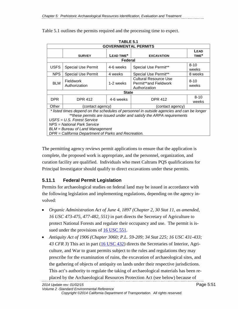
Chapter 5: Prehistoric Archaeological Resources Identification, Evaluation and Treatment
2014 Update rev: 01/02/15 Page 5:51 Volume 2 -Standard Environmental Reference
Copyright ©2014 California Department of Transportation. All rights reserved.
Table 5.1 outlines the permits required and the processing time to expect.
TABLE 5.1 GOVERNMENTAL PERMITS
SURVEY LEAD TIME* EXCAVATION LEAD TIME*
Federal
USFS Special Use Permit 4-6 weeks Special Use Permit** 8-10 weeks
NPS Special Use Permit 4 weeks Special Use Permit** 8 weeks
BLM Fieldwork Authorization 1-2 weeks
Cultural Resource Use Permit**and Fieldwork Authorization
8-10 weeks
State
DPR DPR 412 4-6 weeks DPR 412 8-10 weeks
Other (contact agency) (contact agency) * listed times depend on the schedules of personnel in outside agencies and can be longer
**these permits are issued under and satisfy the ARPA requirements USFS = U.S. Forest Service NPS = National Park Service BLM = Bureau of Land Management DPR = California Department of Parks and Recreation.
The permitting agency reviews permit applications to ensure that the application is complete, the proposed work is appropriate, and the personnel, organization, and curation facility are qualified. Individuals who meet Caltrans PQS qualifications for Principal Investigator should qualify to direct excavations under these permits.
5.11.1 Federal Permit Legislation Permits for archaeological studies on federal land may be issued in accordance with the following legislation and implementing regulations, depending on the agency in-volved:
• Organic Administration Act of June 4, 1897 (Chapter 2, 30 Stat 11, as amended, 16 USC 473-475, 477-482, 551) in part directs the Secretary of Agriculture to protect National Forests and regulate their occupancy and use. The permit is is-sued under the provisions of 16 USC 551.
• Antiquity Act of 1906 (Chapter 3060; P.L. 59-209; 34 Stat 225; 16 USC 431-433; 43 CFR 3) This act in part (16 USC 432) directs the Secretaries of Interior, Agri-culture, and War to grant permits subject to the rules and regulations they may prescribe for the examination of ruins, the excavation of archaeological sites, and the gathering of objects of antiquity on lands under their respective jurisdictions. This act’s authority to regulate the taking of archaeological materials has been re-placed by the Archaeological Resources Protection Act (see below) because of
Chapter 5: Prehistoric Archaeological Resources Identification, Evaluation and Treatment
2014 Update rev: 01/02/15 Page 5:52 Volume 2 -Standard Environmental Reference
Copyright ©2014 California Department of Transportation. All rights reserved.
conflicting federal circuit court decisions as to the validity of the Antiquity Act’s provisions regarding cultural items. No permits should actually be issued under the auspices of this act.
• The Federal Land Policy and Management Act of 1976 [FLPMA] (P. L. 94-579; 43 USC 1701-1784) provides in part for the periodic and systematic inventory of public lands and their resources, and the management of the resources in a manner that will protect the quality of the land. The permit is issued under 43 USC 1732 and P.L. 94-579 Section 302(b).
• Archaeological Resources Protection Act of 1979 [ARPA] (P. L. 96-95; 93 Stat 721; 16 USC 470 aa-11; 36 CFR 229; 43 CFR 7) provides primarily for the pro-tection of archaeological resources on federal lands and Indian lands. A permit is required for the surface collection and/or excavation of sites 100 years or older (16 USC 470cc). The implementing Uniform Regulations for ARPA were pub-lished in the Federal Register, Volume 29, No. 4, Friday January 6, 1984, with supplemental regulations issued in the Federal Register, Volume 52, No. 55, Monday, March 23, 1987. Identical regulations for the different federal landhold-ing agencies appear under different titles of the Code of Federal Regulations; thus the implementing regulations for the US Department of Defense is 32 CFR 229, and the regulations for the BLM and the NPS (Department of the Interior) can be found under 43 CFR 7.
All ARPA permit applications that involve collection and/or excavation are submitted by the permitting agency to the Native American group for whom the site or area may have cultural or religious significance for a 30-day review and comment period. The permitting agency will also require additional notification and consultation if the ac-tivity proposed may result in the excavation of human remains, funerary objects, sa-cred objects, or objects of cultural patrimony as provided for in subpart B of the Na-tive American Graves Protection and Repatriation Act (NAGPRA) regulations (43 CFR 10).
Bureau of Land Management (BLM) Cultural Resource Use Permit The BLM issues permits for two levels of study. The non-collection sur-vey/recordation permit, issued under FLPMA, authorizes non-disturbing pedestrian survey and limited subsurface probing for mapping purposes only (e.g., determination of boundaries). No collection of artifacts, except isolated artifacts not associated with an archaeological site, is allowed under this permit. To remain in compliance with the permit, Caltrans must provide copies of any reports discussing work conducted under such permits to the agency.

Chapter 5: Prehistoric Archaeological Resources Identification, Evaluation and Treatment
2014 Update rev: 01/02/15 Page 5:53 Volume 2 -Standard Environmental Reference
Copyright ©2014 California Department of Transportation. All rights reserved.
Caltrans has a statewide non-collection survey/recordation permit for survey on BLM lands. CSO maintains a list of staff who are identified on the permit. The archaeolo-gist conducting the survey must notify the appropriate BLM Field Office Manager before any fieldwork begins and will be required to submit a fieldwork authorization request. The authorization to conduct fieldwork may be granted immediately, or it may take one to two weeks (see below).
An ARPA permit is issued on a project-specific basis for activities that may disturb the research potential of the site. These activities include limited testing, excavation, and collection. Two copies of the application, including supporting documentation, are submitted to the BLM State Director, California State Office, Sacramento. A complete copy also should be forwarded to the appropriate (local) Field Office at this time. The BLM Field Office submits the application package to the designated Na-tive American group for a 30-day review period. Caltrans, as the applicant, should anticipate a minimum period of 8-10 weeks before an ARPA permit is granted. This allows for review by the Native Americans and the BLM and for inter-agency trans-mittals of the application.
The BLM permitting process involves two levels of approval:
1) For survey projects, the archaeologist conducting the survey submits the Field-work Authorization form only to BLM staff at the local level (i.e., the appropriate BLM Field Office Manager).
2) For collection or excavation projects, the archaeologist conducting the work must submit an application for the Cultural Resource Use (ARPA) Permit to the state headquarters of the BLM.
If Caltrans is contracting the work out, the contractor conducting the work must be the applicant for the Cultural Resource Use Permit. It is strongly recommended that a copy of the application also be forwarded to the local BLM Field Office at this time, in order to keep local staff apprised of the status of the project. The Deputy State Di-rector, Division of Natural Resources, then signs the permit.
Once the permit is issued, the applicant must submit another Fieldwork Authorization form to the appropriate BLM Field Office before initiating fieldwork. This serves to ensure that the Field Office is properly notified and that the schedule of the permitted activity does not conflict with other concurrent activities or conditions in the field. The Field Office Manager is notified by the applicant submitting a Fieldwork Author-

Chapter 5: Prehistoric Archaeological Resources Identification, Evaluation and Treatment
2014 Update rev: 01/02/15 Page 5:54 Volume 2 -Standard Environmental Reference
Copyright ©2014 California Department of Transportation. All rights reserved.
ization request form (which describes the personnel involved, location, and period of the proposed fieldwork). The appropriate BLM Field Office Manager must authorize any fieldwork under this permit before fieldwork commences.
U.S. Forest Service (USFS) Special Uses Permits The USFS issues permits under the Organic Administration Act of 1897 or ARPA, as outlined in 36 CFR 251.50 Special Uses Permits. The procedures and requirements for obtaining a permit vary between Forests, as does Forest organizational structure.
Special Use Permits are issued for two levels of study:
1) Survey (including limited subsurface testing for boundary definition)
2) Surface collection, testing, or data recovery excavations. For either type of per-mit, the lead archaeologist initiates the application process by contacting the ap-propriate Forest Archaeologist
Either the forest supervisor or the district ranger reviews and approves the application for a survey permit. A review period of 30 days can be anticipated.
The USFS submits the permits for surface collection or excavation to the Pacific Southwest Region headquarters for review, approval, and issuance of the permit. The permitting process may take several months.
The project archaeologist notifies the district ranger of the date fieldwork will be ini-tiated. The district ranger approves this date in writing.
National Park Service (NPS) Cultural Resource Special Use Permits National Park Service permit requirements for surveys depend on the nature and scale of the proposed project. The NPS issues permits under ARPA for all collection or excavation. To initiate the permit process, the project archaeologist calls the appro-priate Park office and the NPS Pacific West Regional Office. Two copies of an ap-plication and attachments are prepared and sent to the Pacific West Regional Director for approval. The time for processing the permit is typically four weeks for survey and eight weeks for excavations.
Chapter 5: Prehistoric Archaeological Resources Identification, Evaluation and Treatment
2014 Update rev: 01/02/15 Page 5:55 Volume 2 -Standard Environmental Reference
Copyright ©2014 California Department of Transportation. All rights reserved.
5.11.2 California Permit Legislation
California Department of Parks and Recreation (DPR) Permits Archaeological investigations or collection within the boundaries of units of the State Park System require a permit. This permit is issued for surveys under a DPR Re-source Management Directive. Permits for excavations are issued under the provi-sions of PRC 5097.5, which states that permission is necessary to excavate or remove any archaeological, paleontological, or historical feature situated on public lands from the agency having jurisdiction over that land.
Four copies of an "Application and Permit to Conduct Archaeological or Paleontolog-ical Investigations/Collections on Lands of the State of California (DPR 412)" are submitted to the district superintendent or to the supervisor of the cultural heritage Section. The permit is reviewed by the district superintendent, the supervisor of the cultural heritage section, as well as by the manager for archaeological collections if the requested permit is for an excavation. Review period is ten (10) working days. The regional director signs approval of the permit. Once the permit is granted, the project archaeologists must contact the district superintendent or designee before be-ginning fieldwork.
California Coastal Commission Permits Archaeological excavation undertaken in the coastal zone may require a permit under the authority of the California Coastal Act of 1976 (Public Resources Code, Division 20). The Commission may issue a Coastal Development Permit for archaeological undertakings. When appropriate, the permit requirements may be waived. To deter-mine whether such a permit is needed, the project archaeologist contacts the appro-priate district office of the Commission.
For some cities and counties the Commission has approved local Coastal Plans (LCPs). The Commission’s district office can indicate whether the permit must be obtained from a local agency. Archaeological requirements for permits issued under various LCPs vary.
California Department of Fish and Wildlife (CDFW) Permits In rare cases, permits from the Department of Fish and Wildlife (CDFW) may be re-quired for archaeological excavations involving streams or rivers. If an archaeologi-cal excavation is conducted in a stream or riverbed or on adjacent banks, a Section 1601 Permit may be required. When considering the use of wet screening, it should be noted that some streams are off-limits for any such use because of their sensitivity
Chapter 5: Prehistoric Archaeological Resources Identification, Evaluation and Treatment
2014 Update rev: 01/02/15 Page 5:56 Volume 2 -Standard Environmental Reference
Copyright ©2014 California Department of Transportation. All rights reserved.
to siltation. Others have various seasonal restrictions, and still other streams have unrestricted use. If the excavation will include wet screening that allows archaeolog-ical deposits to flow into the watercourse, a Suction Dredge Permit may be required. The appropriate CDFW Regional Office should be contacted to determine whether a permit is needed. Contacts should be coordinated through the district biologist.
Right of Entry Permits / Private Land Owner Permission Agreements A district ROW agent normally obtains right of entry for archaeologists and other en-vironmental specialists conducting studies on private land. However, it is the respon-sibility of the project archaeologist to inform the environmental planner and/or ROW agent of his or her needs in this regard. Coordination between the archaeologist and the environmental planner and/or ROW agent should take place as early as possible because substantial time may be required to obtain the permits for large surveys.
The district ROW agent contacts the private landowner and seeks written permission to enter, giving the following information:
• Proposed survey or excavation activities • Duration of access • Archaeological project's potential effects on the property
Written permission is required for all excavations, in order to protect the owners against damage or interference with possession or use of the property, and to absolve them of liability in the event of accident.
Because the owner is agreeing to specific conditions, it is important that the project archaeologist plan a field strategy as completely as possible prior to the ROW agent contacting the landowner, thus avoiding having to ask permission a second time to add additional activities that might be of concern to a landowner (such as use of a backhoe). If there are verbal objections to survey work, or if written permission for excavations cannot be obtained, the DEBC and the CSO Chief should be notified. It is possible to obtain entry through the “Right of Eminent Domain,” but this is an ex-treme step that is rarely used.
Archaeological materials recovered from private lands legally are the landowner’s property and may be retained by the landowner. Caltrans must obtain written permis-sion from the property owner to curate the recovered material. This issue should be addressed in the original letter requesting permission to excavate. Failure to obtain this permission will not necessarily affect achieving project compliance. However,
Chapter 5: Prehistoric Archaeological Resources Identification, Evaluation and Treatment
2014 Update rev: 01/02/15 Page 5:57 Volume 2 -Standard Environmental Reference
Copyright ©2014 California Department of Transportation. All rights reserved.
Caltrans must try to ensure that archaeological materials will be stored properly and that they will be accessible to qualified researchers upon request. Every effort should be made to convince the landowner of the value of proper curation for all site arti-facts.
5.12 Archaeological Studies: Preconstruction, Maintenance, Excess Property Disposal, and Encroachment Permits
The DEB responsibilities toward cultural resources and coordinating with Native American Tribes, groups or individuals are outlined in Chapters 1 and 3. These re-sponsibilities extend beyond project specific situations to include any Caltrans activi-ties that have the potential to affect cultural resources. This section addresses these activities and the concomitant responsibilities of the district to ensure protection of archaeological resources.
The DEB provides archaeological studies for preconstruction and maintenance activi-ties that involve ground disturbance within the existing right-of-way. Follow Caltrans archaeological procedures outlined in the preceding sections when archaeological re-sources are identified and the archaeological resource cannot be avoided nor can the proposed work be abandoned.
Consult the DEBC before the disposal of excess parcels and before issuing an en-croachment permit to ensure environmental compliance. For excess parcels, the Branch will conduct a survey of the parcel and document the survey. For encroach-ment permits, environmental compliance is the responsibility of the permit applicant. The Caltrans PQS reviews the proposal of archaeological work and the resulting stud-ies for compliance with Section 106 and the stipulations in the Section 106 PA, CEQA and PRC 5024 and the stipulations in the 5024 MOU (when state-owned ar-chaeological resources are involved). Chapter 2 discusses the process for compliance with CEQA and PRC 5024.
5.12.1 Preconstruction Studies Section 106 compliance should be completed prior to the approval of the expenditure of any federal funds on the undertaking, or prior to the issuance of any license or permit. It is often necessary, however, to conduct project-planning studies prior to completion of Section 106 consultation. Such studies might include hazardous mate-rials testing, soil borings, percolation tests, etc. The regulations at 36 CFR 800 rec-ognize this need and allow for some flexibility in carrying out the Section 106 pro-

Chapter 5: Prehistoric Archaeological Resources Identification, Evaluation and Treatment
2014 Update rev: 01/02/15 Page 5:58 Volume 2 -Standard Environmental Reference
Copyright ©2014 California Department of Transportation. All rights reserved.
cess. 36 CFR 800.1(c) states that the requirement to complete the Section 106 pro-cess prior to approval of the undertaking
… does not prohibit agency official from conducting or authorizing nondestructive project planning activities before completing compli-ance with section 106, provided that such actions do not restrict the subsequent consideration of alternatives to avoid, minimize, or miti-gate the undertaking’s adverse effects on historic properties.
Note that such activities must be nondestructive to potential historic properties and must not restrict consideration of alternatives.
When preconstruction activities that involve ground-disturbing work are necessary, the project team leader must contact the DEBC. Caltrans PQS review the proposed studies and identify any cultural resources that may be affected by the proposed work. The DEBC usually has the information needed to evaluate the potential impacts of preconstruction activities in the form of environmental analyses already conducted for the proposed construction work. An archaeological survey, however, may be needed if those analyses have not been done. Then, the Caltrans PQS may work with the Project Team Leader to redesign the preconstruction activity to avoid any effect to potential historic properties. If avoidance is not possible, the activity is subject to consultation under the Section 106 PA.
5.12.2 Maintenance Projects The district Maintenance Engineer is responsible for consulting with the DEBC, and the DEBC needs to continually apprise the district Maintenance Engineer of the loca-tion of resources that could be disturbed by maintenance operations. Maintenance operations that have the greatest potential for impact to archaeological resources in-clude those activities that involve the removal, grading, and filling of material, and trenching within the right-of-way. An archaeological survey may be needed to identi-fy any archaeological resources. If resources are identified, CEQA and/or PRC 5024 and the stipulations in 5024 MOU (for state-owned archaeological resources) apply; either the resources are avoided, or the studies outlined above, are followed in order to comply with the applicable state law(s).
5.12.3 Excess Property Disposal Excess parcel disposal is usually subject only to state laws and regulations, but also may be subject to federal laws and regulations if a federal agency initially participat-ed in acquiring the parcel or in associated construction. For the former, however, if

Chapter 5: Prehistoric Archaeological Resources Identification, Evaluation and Treatment
2014 Update rev: 01/02/15 Page 5:59 Volume 2 -Standard Environmental Reference
Copyright ©2014 California Department of Transportation. All rights reserved.
the participating federal agency has since relinquished the parcel and Caltrans was reimbursed, then the disposal is treated as a state-only action.
The DEBC ensures review of all excess property proposed sales for environmental considerations, including the presence of archaeological resources. As part of this review, an archaeological survey may be required. The survey is documented in an ASR.
If archaeological resources are present, conveyance of the parcel is contingent on compliance with CEQA, with the stipulations in the PRC 5024 MOU Stipulation XVI and Attachments 5 and 6 for state-owned parcels, and with Section 106 and Section 4(f), if applicable. Pursuant to the California Streets and Highway Code, Section 118.6, the excess parcel with an archaeological site must be offered for sale or ex-change to appropriate public agencies operating parks and recreational areas before the parcel can be offered to the public. The prospective buyer is informed of the presence of the archaeological resource(s) and their responsibilities for obtaining the appropriate environmental compliance as a condition of the sale. The Director’s Deed and Notice of Terms of Sale both need to include protective covenants or con-servation easements that govern the preservation of the archaeological site(s).
These protective covenants or conservation easements include:
1) “Adequate restrictions or conditions [to] ensure preservation of the property’s significant historic features” to satisfy Section 106 and PRC 5024 or
2) The establishment of a preservation easement to protect the site as noted in CEQA. The buyer also may proceed with additional archaeological studies to comply with state and federal law, as appropriate
Further guidance on the laws and procedures related to the disposal of excess proper-ty that may contain archaeological sites is provided in Exhibit 2.17. See also Chapter 2 Section 2.8 and Section 2.9 regarding state-owned resources.
5.12.4 Encroachment Permits Caltrans PQS must review encroachment permit applications involving ground-disturbing activities to determine whether there are archaeological concerns. The DEBC determines:
• Whether an archaeological survey is needed and • Whether Caltrans or the applicant will conduct the survey.
Chapter 5: Prehistoric Archaeological Resources Identification, Evaluation and Treatment
2014 Update rev: 01/02/15 Page 5:60 Volume 2 -Standard Environmental Reference
Copyright ©2014 California Department of Transportation. All rights reserved.
As with Caltrans’ own surveys, the decision to survey is based on the nature of the proposed activity and the sensitivity of the location for archaeological resources
If archaeological resources are identified, the permit holder must submit a proposal of archaeological work to be performed to the DEBC for review. The DEBC reviews the proposed work to determine whether it meets Caltrans standards. The permit holder must provide with documentation of compliance with appropriate state or fed-eral historic preservation laws and archaeological compliance before the permit is is-sued.
Each permit is issued with General Provisions and Special Provisions that the permit holder must fully carry out. The General Provisions include the requirement that the permit holder must:
1) “Cease work” in the vicinity of any archaeological resources that are revealed
2) Notify the Permit Engineer immediately of such a find
Then, a qualified archaeologist retained by the permit holder must evaluate the situa-tion and make recommendations to the Permit Engineer concerning continuation of work. Special Provisions may further address archaeological concerns. The DEBC may be called upon to inspect the work under a permit.
5.13 Peer Review and Approval of Archaeological Documents
Prior to the distribution of the archaeological studies, reports and documents, there need to be three reviews:
1) District or CSO PQS, who is someone other than the author(s) of the documents, must peer review the Caltrans staff- and consultant-prepared draft documents.
2) District PQS must review and approve the final document, under the terms of the Section 106 PA Stipulation XVIII/5024 MOU Stipulation XVII. For Caltrans-prepared documents, if the Caltrans PQS is certified at the appropriate PQS level, his or her signature on the final document as document preparer also signifies re-view for DEBC approval.
3) DEBC must review and approve the final document.

Chapter 5: Prehistoric Archaeological Resources Identification, Evaluation and Treatment
2014 Update rev: 01/02/15 Page 5:61 Volume 2 -Standard Environmental Reference
Copyright ©2014 California Department of Transportation. All rights reserved.
5.13.1 Peer Review Peer reviews are considered part of the report preparation process. Peer reviewers can be identified in the acknowledgement section of the archaeological documents or in a table of personnel working on the environmental studies. That is separate from PQS approval of completed documents prior to submittal, which is required under the Section 106 PA. See Section 5.13.2 below.
In accordance with Caltrans Quality Assurance and Quality Control policy and the Section 106 PA Stipulation XVIII/5024 MOU Stipulation XVII, Caltrans PQS certi-fied in the relevant discipline at the Co-Principal Investigator level or higher17 must peer review:
• Archaeological Study Reports • Extended Phase I Proposals • Extended Phase I Reports • Archaeological Evaluation Proposals (formerly called Phase II proposals) • Archaeological Evaluation Reports (formerly called Phase II reports) • Data Recovery Plans • Phase III Proposals • Phase III Reports
Draft versions of curation agreements, monitoring plans, post review discovery plans and construction impact reports also require peer review by a Caltrans PQS Principal Investigator. Either district or CSO PQS may conduct the peer review.
If a DEBC requests peer review by another district or CSO PQS, the DEBC submits the request to the appropriate DEBC or to the appropriate CSO Branch Chief. Such reviews, whether in the district or in CSO, will be completed within fifteen (15) working days of receipt of the request. However, longer review periods may be al-lowed at the discretion of the DEBC. Chapter 2 Section 2.5.5 discusses Caltrans in-ternal review guidelines.
Likewise, CSO PQS certified at the Principal Investigator18 level in the relevant dis-cipline peer review the CSO-prepared draft archaeological documents. Upon approv-al, the CSO Branch Chief or CSO Office Chief transmits the CSO-prepared docu-ments to the requesting DEBC. Upon receipt, the DEBC has ten (10) working days to
17 See Exhibit 2.11 Table C 18 However, Co-Principal Investigators or higher may peer review ASRs.
Chapter 5: Prehistoric Archaeological Resources Identification, Evaluation and Treatment
2014 Update rev: 01/02/15 Page 5:62 Volume 2 -Standard Environmental Reference
Copyright ©2014 California Department of Transportation. All rights reserved.
comment on the draft document, after which it is assumed to have met with the DEBC’s approval.
The process for resolving disagreements and differences of opinion regarding Cal-trans or consultant-prepared findings is outlined in Chapter 2 Section 2.11.
5.13.2 Caltrans Review and Approval of Archaeological Documents Following peer review (whether by district or CSO PQS), and any necessary revisions based on comments received, the report preparer signs the title page of the final ar-chaeological document and the final document is reviewed for approval by a Caltrans PQS at the appropriate level; see Exhibit 2.11 Table C. If a Caltrans PQS has not prepared the document, then the responsible PQS indicates review and approval by signing the title page. The DEBC finally reviews and formally approves the docu-ment by signing the title page.
5.13.3 Report Distribution The district PQS is responsible for ensuring that the appropriate archaeological doc-uments are attached to the HPSR, HRCR, or Finding of Effect, or are distributed sep-arately and that the correct number of copies is sent to CSO and others, as appropri-ate. Exhibit 2.11 Table B lists the copies of approved archaeological documents that are required. See Chapter 2 for specific guidance on transmitting reports to FHWA and SHPO.
The district keeps a record of the peer review in its files. The transmittal memo ac-companying the approved archaeological documents identifies the peer reviewers of documents. For federal undertakings, if the transmittal memo to the DEBC provides any recommendations concerning the resource, a copy of the memo is included in the package sent to the CSO Section 106 Branch Chief.
5.14 State-Owned Archaeological Resources In addition to compliance with federal and state laws relative to archaeological resources, Caltrans also
must comply with PRC 5024 when state-owned archaeological resources are involved. Pursuant to PRC 5024(d), archaeological sites that are listed in the NRHP or are registered as California Historical Landmarks are listed on the Master List of State-Owned Historical Resources (Master List). The Mas-
ter List does not include state-owned archaeological resources that have been determined eligible through a consensus determination under Section 106 or PRC 5024 and it does not include state-owned
archaeological resources that Caltrans has assumed eligible for the purposes of an undertaking under Section 106 or under PRC 5024 assumed eligible only for the purposes of a project or activity.
Chapter 2 Section 2.8 contains guidance on the applicability of PRC 5024, while Section 2.9 provides guidance on the documentation needed to consult with SHPO on state-owned archaeological resources. Questions about the applicability of PRC 5024 to archaeological sites may be directed to the CSO Built
Environment Preservation Services (BEPS) Branch Chief.
Chapter 5: Prehistoric Archaeological Resources Identification, Evaluation and Treatment
2014 Update rev: 01/02/15 Page 5:63 Volume 2 -Standard Environmental Reference
Copyright ©2014 California Department of Transportation. All rights reserved.