
Chapter 5. Physical Resources 5.1. Air Quality 5.1.1 ...
29
Draft Environmental Impact Report California Marine Life Protection Act Initiative Central Coast Marine Protected Areas Project 5-1 November 2006 J&S 06682.06 Chapter 5. Physical Resources 5.1. Air Quality This chapter describes the environmental setting for air quality, impacts on air quality that would result from the Proposed Project and its alternatives and, mitigation measures that would reduce these impacts, as appropriate. It also discusses federal and state ambient air quality standards and existing air quality conditions in the central coast study region, identifies sensitive receptors in the study region, and describes the overall regulatory framework for air quality management in California and the study region. 5.1.1. Environmental Setting Climate along the coastline of California varies with cooler temperatures, more rainfall, and more extensive cloud cover in the northern portions of the state. Conditions become milder in a continuum southward. California is divided into 15 air basins to better manage air pollution. The central coast study region encompasses three basins, the San Francisco Bay Area Air Basin (SFBAAB), North Central Coast Air Basin (NCCAB), and South Central Coast Air Basin (SCCAB). The study region is located within five coastal California counties: San Mateo, Santa Cruz, Monterey, San Luis Obispo, and Santa Barbara. San Mateo County is located within the SFBAAB. The SFBAAB consists of the entirety of Alameda, Contra Costa, Marin, Napa, San Francisco, San Mateo, and Santa Clara Counties, as well as portions of Solano and Sonoma Counties. Within the SFBAAB, the Bay Area Air Quality Management District (BAAQMD) has jurisdiction over air quality issues. Santa Cruz and Monterey Counties are located within the NCCAB. The NCCAB also includes San Benito County. Within the NCCAB, the Monterey Bay Unified Air Pollution Control District (MBUAPCD) has jurisdiction over air quality issues. San Luis Obispo and Santa Barbara Counties are located within the SCCAB. Within the SCCAB, the San Luis Obispo Air Pollution Control District (SLOAPCD) and the Santa Barbara Air Pollution Control District (SBACPD) have jurisdiction over air quality issues. 5.1.1.1. Sensitive Receptors For air quality analysis, sensitive land uses are defined as locations where people reside or where the presence of air pollutant emissions could adversely affect the use of the land. Typical sensitive receptors include residents, school children, hospital patients, and the elderly. There are no sensitive receptors identified within state waters within the study region.
Transcript of Chapter 5. Physical Resources 5.1. Air Quality 5.1.1 ...

Draft Environmental Impact Report California Marine Life Protection Act Initiative Central Coast Marine Protected Areas Project
5-1
November 2006
J&S 06682.06
Chapter 5. Physical Resources
5.1. Air Quality
This chapter describes the environmental setting for air quality, impacts on air quality that would result from the Proposed Project and its alternatives and, mitigation measures that would reduce these impacts, as appropriate. It also discusses federal and state ambient air quality standards and existing air quality conditions in the central coast study region, identifies sensitive receptors in the study region, and describes the overall regulatory framework for air quality management in California and the study region.
5.1.1. Environmental Setting
Climate along the coastline of California varies with cooler temperatures, more rainfall, and more extensive cloud cover in the northern portions of the state. Conditions become milder in a continuum southward. California is divided into 15 air basins to better manage air pollution. The central coast study region encompasses three basins, the San Francisco Bay Area Air Basin (SFBAAB), North Central Coast Air Basin (NCCAB), and South Central Coast Air Basin (SCCAB).
The study region is located within five coastal California counties: San Mateo, Santa Cruz, Monterey, San Luis Obispo, and Santa Barbara. San Mateo County is located within the SFBAAB. The SFBAAB consists of the entirety of Alameda, Contra Costa, Marin, Napa, San Francisco, San Mateo, and Santa Clara Counties, as well as portions of Solano and Sonoma Counties. Within the SFBAAB, the Bay Area Air Quality Management District (BAAQMD) has jurisdiction over air quality issues.
Santa Cruz and Monterey Counties are located within the NCCAB. The NCCAB also includes San Benito County. Within the NCCAB, the Monterey Bay Unified Air Pollution Control District (MBUAPCD) has jurisdiction over air quality issues.
San Luis Obispo and Santa Barbara Counties are located within the SCCAB. Within the SCCAB, the San Luis Obispo Air Pollution Control District (SLOAPCD) and the Santa Barbara Air Pollution Control District (SBACPD) have jurisdiction over air quality issues.
5.1.1.1. Sensitive Receptors
For air quality analysis, sensitive land uses are defined as locations where people reside or where the presence of air pollutant emissions could adversely affect the use of the land. Typical sensitive receptors include residents, school children, hospital patients, and the elderly. There are no sensitive receptors identified within state waters within the study region.

California Department of Fish and Game Physical Resources
Draft Environmental Impact Report California Marine Life Protection Act Initiative Central Coast Marine Protected Areas Project
5-2
November 2006
J&S 06682.06
5.1.1.2. Existing Air Pollution Concentrations
Existing air quality conditions in the study region can be characterized in terms of the ambient air quality standards that the federal and state governments have established for several different pollutants. For some pollutants, separate standards have been set for different measurement periods. Most standards have been set to protect public health; for others, standards are based on other values (e.g., protection of crops, protection of materials, avoidance of nuisance conditions). Table 5.1-1 lists the state and federal standards for a variety of pollutants. The pollutants of greatest concern to the Proposed Project are described below. Toxic air contaminants, though not a criteria pollutant1, are also described below.
Ozone
Ozone is a respiratory irritant that increases susceptibility to respiratory infections. It is also an oxidant that can cause substantial damage to vegetation and other materials. Ozone is not emitted directly into the air, but is formed by a photochemical reaction in the atmosphere. Ozone precursors, called reactive organic gases (ROG) and oxides of nitrogen (NOx), react in the atmosphere in the presence of sunlight to form ozone. Because photochemical reaction rates depend on the intensity of ultraviolet light and air temperature, ozone is primarily a summer problem. Ozone is considered a regional pollutant. Because photochemical reactions take time to occur, high ozone levels often occur downwind of the emission source. The study region is a receptor of regional pollutants from inland areas. Therefore, ozone conditions in the area result from a combination of locally generated and transported emissions.
Inhalable Particulate Matter
Inhalable particulate matter consists of many different substances suspended in air in the form of particles (solids or liquid droplets) that vary widely in size. Examples include dust and smoke. Particulate matter that is 10 microns or less in diameter (PM10) can damage human health and retard plant growth. Health concerns associated with suspended particulate matter focus on those particles small enough to reach the lungs when inhaled. Particulates also reduce visibility and corrode materials. Particulate emissions are generated by a wide variety of sources, including agricultural activities, industrial emissions, dust suspended by vehicle traffic and construction equipment, and secondary aerosols formed by reactions in the atmosphere.
Carbon Monoxide (CO)
Carbon monoxide (CO) is a public health concern because it combines readily with hemoglobin and reduces the amount of oxygen transported in the bloodstream. CO can cause health problems such as fatigue, headache, confusion, dizziness, and even
1 Criteria pollutant – refers to pollutants identified by the EPA as indicators of air quality. These include ozone, CO, lead, nitrogen dioxide (NO2), particulate matter, and sulfur dioxide (SO2).

Table 5.1-1. Ambient Air Quality Standards Applicable in California Page 1 of 2
Standard (parts per million)
Standard (micrograms
per cubic meter) Violation Criteria Pollutant Symbol
Average Time California National California National California National 1 hour 0.09 – 180 – If exceeded – Ozone O3 8 hours 0.070 0.08 137 157 If exceeded If fourth highest 8-hour concentration in a
year, averaged over 3 years, is exceeded at each monitor within an area
8 hours 9.0 9 10,000 10,000 If exceeded If exceeded on more than 1 day per year Carbon monoxide
CO 1 hour 20 35 23,000 40,000 If exceeded If exceeded on more than 1 day per year
(Lake Tahoe only)
8 hours 6 – 7,000 – If equaled or exceeded
–
Annual average
– 0.053 – 100 – If exceeded on more than 1 day per year Nitrogen dioxide
NO2
1 hour 0.25 – 470 – If exceeded – Annual average
– 0.030 – 80 – If exceeded
24 hours 0.04 0.14 105 365 If exceeded If exceeded on more than 1 day per year
Sulfur dioxide SO2
1 hour 0.25 – 655 – If exceeded – Hydrogen sulfide
H2S 1 hour 0.03 – 42 – If equaled or exceeded
–
Vinyl chloride C2H3Cl 24 hours 0.01 – 26 – If equaled or exceeded
–
Annual geometric mean
– – 20 – If exceeded –
Annual arithmetic mean
– – – 50 – If exceeded at each monitor within area
Inhalable particulate matter
PM10
24 hours – – 50 150 If exceeded If exceeded on more than 1 day per year

Table 5.1-1. Continued. Page 2 of 2
Standard (parts per million)
Standard (micrograms
per cubic meter) Violation Criteria Pollutant Symbol
Average Time California National California National California National Annual geometric mean
– – – – If exceeded –
Annual arithmetic mean
– – 12 15 – If 3-year average from single or multiple community-oriented monitors is exceeded
PM2.5
24 hours – – – 65 – If 3-year average of 98th percentile at each population-oriented monitor within an area is exceeded
Sulfate particles
SO4 24 hours – – 25 – If equaled or exceeded
–
Calendar quarter
– – – 1.5 – If exceeded no more than 1 day per year Lead particles Pb
30-day average
– – 1.5 – If equaled or exceeded
–
Notes: All standards are based on measurements at 25ºC and 1 atmosphere pressure. National standards shown are the primary (health effects) standards. – = not applicable. Source: ARB 2006a.

California Department of Fish and Game Physical Resources
Draft Environmental Impact Report California Marine Life Protection Act Initiative Central Coast Marine Protected Areas Project
5-3
November 2006
J&S 06682.06
death. Motor vehicles are the dominant source of CO emissions in most areas. High CO levels develop primarily during winter, when periods of light winds combine with the formation of ground-level temperature inversions (typically from evening through early morning). These conditions result in reduced dispersion of vehicle emissions. Motor vehicles also exhibit increased CO emission rates at low air temperatures.
Toxic Air Contaminants
Many pollutants are identified as toxic air contaminants (TACs) because of their potential to increase the risk of developing cancer or their acute or chronic health risks. Individual TACs vary greatly in the risk they present. At a given level of exposure, one TAC may pose a hazard that is many times greater than another.
There are no state or federal standards for TACs. However, for TACs that are known or suspected carcinogens, the California Air Resources Board (ARB) has consistently found that there are no levels or thresholds below which exposure is risk-free. For certain TACs, a unit risk factor can be developed to evaluate cancer risk. For acute and chronic health risks, a similar factor called a hazard index is used to evaluate risk.
In the early 1980s, the ARB established a statewide comprehensive air toxics program to reduce exposure to air toxics. The Toxic Air Contaminant Identification and Control Act (Assembly Bill [AB] 1807, Tanner 1983) created California’s program to reduce exposure to air toxics. The Air Toxics “Hot Spots” Information and Assessment Act (AB 2588, Connelly 1987) supplements the AB 1807 program by requiring a statewide air toxics inventory, notification of people exposed to a significant health risk, and facility plans to reduce these risks.
5.1.1.3. Attainment Status
Generally, the ARB designates whether areas are in attainment of air quality standards by air basin or county (see “Regulatory Setting” below). When areas in an air basin or county have distinctly different air quality deriving from sources and conditions not affecting the entire air basin or county, the ARB may designate a smaller area.
Table 5.1-2 presents the area designations and attainment status in the affected air basins in the study region for CO, PM10, and ozone. The table identifies areas as attainment, nonattainment, nonattainment-transitional, or unclassified for these pollutants. The boundaries of the designated areas that differ from the air basin or county boundaries are described at the bottom of the table.

California Department of Fish and Game Physical Resources
Draft Environmental Impact Report California Marine Life Protection Act Initiative Central Coast Marine Protected Areas Project
5-4
November 2006
J&S 06682.06
Table 5.1-2. State and Federal Attainment Designations for Air Basins in the Project Area
National Ambient Air Quality Standards
California Ambient Air Quality Standards
Air Basin CO PM10 Ozone COa PM10 Ozone
San Francisco Bay Area Air Basin U/A U/A N A N N
North Central Coast Air Basinb U/A U/A U/A – N NT
Monterey County – – – A – –
Santa Cruz County – – – U – –
South Central Coast Air Basin U/A U/A – A N –
San Luis Obispo Countyb – – U/A – – NT
Basin except San Luis Obispo County – – – – – N
Santa Barbara Countyc – – N – – – Notes: A = attainment; N = nonattainment; NT = nonattainment-transitional; U = unclassified a The area designated for CO is a county or portion of a county. b For ozone, Assembly Bill (AB) 3048 (Olberg) and AB 2525 (Miller), signed into law in 1996, made changes to Health and Safety
Code Section 40925.5. c This area has air quality that meets the 1-hour federal ozone standard. Redesignation requests are pending. The U.S.
Environmental Protection Agency has proposed findings of attainment for Santa Barbara and San Diego.
Class I Areas
Under the federal Clean Air Act Amendments of 1977, Congress established a system for the prevention of significant deterioration to protect areas that were not classified as nonattainment. A classification system was implemented based on the allowable amounts of additional total suspended particulates and sulfur dioxide degradation that would be allowed for various areas. A Class I area has the greatest limitations; virtually any degradation is considered significant. California coastal Class 1 areas include Redwood National Park, Point Reyes National Seashore, Pinnacles National Monument, and the Ventana Wilderness. A portion of the study region is adjacent to the Ventana Wilderness, encompassing the Big Sur coastline and part of the Los Padres National Forest.
5.1.2. Regulatory Framework
5.1.2.1. Federal Regulations
Federal Clean Air Act
The federal Clean Air Act (CAA), enacted in 1970 and amended twice thereafter (including most recently in 1990), establishes the framework for modern air pollution control. The act directs the U.S. Environmental Protection Agency (EPA) to establish national ambient air quality standards (NAAQS) for the six criteria pollutants. The NAAQS are divided into primary and secondary standards. The former are set to protect

California Department of Fish and Game Physical Resources
Draft Environmental Impact Report California Marine Life Protection Act Initiative Central Coast Marine Protected Areas Project
5-5
November 2006
J&S 06682.06
human health within an adequate margin of safety; and the latter to protect environmental values, such as plant and animal life.
The CAA requires states to submit a state implementation plan (SIP) for areas in nonattainment for NAAQS. The SIP, which is reviewed and approved by the EPA, must demonstrate how the NAAQS will be achieved. Failing to submit a plan or secure approval could lead to denial of federal funding and permits. In cases where the SIP is submitted but fails to demonstrate achievement of the NAAQS, the EPA is directed to prepare a federal implementation plan. The applicable SIPs for the study region include the Air Quality Management Plan for the Monterey Bay Region (MBUACPD, 2004) and the Revised San Francisco Bay Area Ozone Attainment Plan for the 1-Hour National Ozone Standard (BAAQMD, 2001).
5.1.2.2. State Regulations
The ARB and local air pollution control districts have responsibility for achieving the California ambient air quality standards (CAAQS), which are more stringent than the comparable NAAQS. The CAAQS are achieved through district-level air quality management plans that are incorporated into the SIP.
The California Clean Air Act (CCAA) requires local and regional districts that are not attaining one or more of the CAAQS for ozone, CO, SO2, or NO2 to expeditiously adopt plans specifically designed to attain these standards. Each plan must be designed to achieve an annual 5% reduction in district-wide emissions of each nonattainment pollutant or its precursors.
Recently enacted amendments to the CCAA impose additional requirements that are designed to ensure an improvement in air quality within the next 5 years. More specifically, local districts with moderate air pollution that did not achieve “transitional nonattainment” status by December 31, 1997, must implement the more stringent measures applicable to districts with serious air pollution.
5.1.2.3. Local Regulations
Four air quality management agencies have jurisdiction in the study region: the BAAQMD, MBUAPCD, SLOCAPCD, and SBCAPCD. The EPA has established NAAQS for which the ARB and these districts have primary implementation responsibility. The ARB and the districts are also responsible for ensuring that CAAQS are met. The districts are also responsible for implementing strategies for air quality improvement and recommending mitigation measures for new growth and development.

California Department of Fish and Game Physical Resources
Draft Environmental Impact Report California Marine Life Protection Act Initiative Central Coast Marine Protected Areas Project
5-6
November 2006
J&S 06682.06
5.1.3. Impact Analysis
5.1.3.1. Methodology
Criteria pollutant emissions were calculated for the portion of all commercial fishing vessels that reported species landings from fishing blocks within the central coast study region. Commercial vessels were found to be primarily associated with the ports of Half Moon Bay, Santa Cruz, Moss Landing, Monterey, Morro Bay, Port San Luis, and Santa Barbara). The number of commercial vessels displaced was then calculated on a species level using the Ecotrust data for area of fishing grounds impacted by the Proposed Project and Alternatives 1 and 2 (Scholz, A., C. Steinback, and M. Mertens 2006b)(see Table 5.1-3).
Table 5.1-3. State and Federal Attainment Designations for Air Basins in the Project Area
Number of Vessels Potentially Displaced Fishery Affected
Number of Vessels Landing
in 2005a Proposed Project Alternative 1 Alternative 2
Anchovy 9 1 1 2
Cabezon 60 10 9 12
Dungeness crab 36 5 3 5
Deep Nearshore Rockfish 72 12 10 13
Halibut 47 5 5 6
Kelp Greenling 60 9 8 11
Lingcod 86 14 11 17
Mackerel 3 0 0 1
Rockfish Nearshore 61 9 8 11
Rockfish Shelf 0 0 0 0
Rockfish Slope 0 0 0 0
Rock Crab 15 2 2 2
Salmon 370 34 22 51
Sardine 10 1 1 2
Sablefish 55 12 4 12
White seabass 6 1 1 1
Surfperch 3 0 0 1
Spot Prawn 7 1 0 1
Squid 15 1 1 2
Total 579 119 88 148 a Vessels that landed these species from fishing blocks within study region.

California Department of Fish and Game Physical Resources
Draft Environmental Impact Report California Marine Life Protection Act Initiative Central Coast Marine Protected Areas Project
5-7
November 2006
J&S 06682.06
Additional travel distances were based on the average MPA along-shore span within each of the primary APCDs in the study region. For the MBUAPCD, the average MPA along-shore span is 3.4 miles, and within the SLOAPCD it is 4.9 miles. Additional travel times were based on averaged vessel characteristics (i.e., length, beam, horsepower) from the Department’s 2005 catch data.
This is believed to represent a reasonably foreseeable consequence of the Proposed Project. However, it should be noted that it is not possible to accurately predict the responses of individual fishermen given that there are many factors that influence the decision to go to sea on a given day. It is also possible that in some instances, appropriate fishing grounds may not occur immediately adjacent to the proposed MPA which displaces the vessel, and thus additional travel distance may be greater than the average MPA along-shore span.
Recreational Fishing
Recreational vessel traffic is qualitatively considered in the impact analysis. Quantitative analysis is not provided as recreational fishing vessel traffic is not anticipated to be measurably affected by the Proposed Project. Some recreational fishing hot spots are located within proposed no-take or restricted take MPAs and, while the Proposed Project and its alternatives attempted to avoid many of the desired locations identified in the California Recreational Fisheries Survey (CDFG 2005a), some inevitably were included within proposed MPAs. It is possible that recreational fishermen will adjust their transit to destinations equally accessible versus electing to transit longer distances and travel times for a comparable fishing experience.
5.1.3.2. Criteria for Determining Significance
State CEQA Guidelines
Based on the standards of significance from the State CEQA Guidelines and professional judgment, a project would result in a significant impact if it would result in any of the following.
• conflict with or obstruction of implementation of an applicable air quality management plan;
• violation of any air quality standard or substantial contribution to an existing or projected air quality violation;
• cumulatively considerable net increase of any criteria pollutant for which the project region is nonattainment under an applicable NAAQS or CAAQS, including releasing emissions that exceed quantitative thresholds for ozone precursors;

California Department of Fish and Game Physical Resources
Draft Environmental Impact Report California Marine Life Protection Act Initiative Central Coast Marine Protected Areas Project
5-8
November 2006
J&S 06682.06
• exposure of sensitive receptors to substantial pollutant concentrations; or
• objectionable odors affecting a substantial number of people.
These thresholds would apply to the entire Proposed Project.
Individual District Thresholds
In addition to the thresholds indicated above, the four air quality management districts in the study region each have thresholds of significance for actions within the respective air basins. These thresholds are described below.
Bay Area Air Quality Management District
Additional emission thresholds are contained in the BAAQMD’s CEQA Guidelines for Assessing the Air Quality Impacts of Projects and Plans (1999). For the portions of the Proposed Project within the BAAQMD, the Proposed Project would result in a significant impact if it would:
• result in a net increase in ROG, NOx, or PM10 emissions of 80 pounds per day (ppd) or 15 tons per year (tpy); or
• result in a net increase in CO emissions exceeding 550 ppd, reduction of roadway level of service (LOS) of intersections operating at LOS E or F, reduction of intersection LOS to E or F, or increase in traffic volumes on nearby roadways by 10% or more, or violation of state CO concentration standards as determined by the modeling of CO emissions.
Monterey Bay Unified Air Pollution Control District
Additional emission thresholds are contained in the MBUAPCD’s CEQA Air Quality Guidelines (2004). For the portions of the Proposed Project within the MBUAPCD, the Proposed Project would result in a significant impact if it would:
• result in construction-related emissions exceeding 82 ppd of PM10; or
• result in operational emissions exceeding 137 ppd of ROG or NOx, 550 ppd of CO, and 82 ppd of PM10.
San Luis Obispo County Air Pollution Control District
Additional emission thresholds are contained in the SLOAPCD’s CEQA Air Quality Handbook (2003). For the portions of the Proposed Project within the SLOAPCD, the Proposed Project would result in a significant impact if it would:

California Department of Fish and Game Physical Resources
Draft Environmental Impact Report California Marine Life Protection Act Initiative Central Coast Marine Protected Areas Project
5-9
November 2006
J&S 06682.06
• result in operational emissions exceeding 10 ppd of ROG, NOx, or PM10, and 550 ppd of CO;
• result in inconsistency with the most recent Clean Air Plan for San Luis Obispo County;
• result in ambient pollutant concentrations exceeding state and federal health standards, when applicable;
• has the potential to emit toxic or hazardous air pollutants;
• is located in close proximity to sensitive receptors;
• result in release of diesel particulate matter (PM) emissions in areas with potential for human exposure; or
• has the potential to cause an odor or other nuisance problem which could impact a considerable number of people.
Santa Barbara County Air Pollution Control District
Additional emission thresholds are contained in the SBAPCD’s Environmental Review Guidelines (2000). For the portions of the Proposed Project within the SBAPCD, the Proposed Project would result in a significant impact if it would result in:
A project would not be considered to have a significant impact if it would:
• emit from all project sources (mobile and stationary) more than the daily trigger for offsets set in the SBCAPCD New Source Review Rule, for any pollutant;
• emit 25 ppd or more of NOx or ROG from motor vehicle trips only;
• cause or contribute to a violation of any CAAQS or NAAQS (except ozone);
• exceed the SBCAPCD health risk public notification thresholds adopted by the SBCAPCD Board; or
• be inconsistent with the adopted federal and state air quality plans.
5.1.3.3. Environmental Impacts
Impact AIR-1: Conflict with or Obstruct Implementation of Applicable Air Quality Plans

California Department of Fish and Game Physical Resources
Draft Environmental Impact Report California Marine Life Protection Act Initiative Central Coast Marine Protected Areas Project
5-10
November 2006
J&S 06682.06
A project is deemed inconsistent with air quality plans if it would result in population and/or employment growth that exceeds growth estimates included in the applicable air quality plan. Therefore, proposed projects need to be evaluated to determine whether they would generate population and employment growth and, if so, whether that growth would exceed the growth rates included in the relevant air plans.
Proposed Project: No Impact
The Proposed Project would not result in an increase in population since it is not a growth-inducing project. Further, the Proposed Project would not result in a net increase in employment, as the Proposed Project would not propose activities that increase employment within the fishing industry. It is possible that displacement of fishing effort resulting from the Proposed Project, in conjunction with other existing fishery management regulations, may contribute to an existing declining trend in the number of fishing vessels. Based on this analysis, the proposed project would not conflict with or obstruct implementation of any of the applicable air quality plans.
Mitigation – No mitigation is required because there would be no impact.
Alternative 1: No Impact
Potential effects associated with Alternative 1 would be the same as those described above for the Proposed Project. Therefore, Alternative 1 would not result in an impact.
Mitigation – No mitigation is required because there would be no impact.
Alternative 2: No Impact
Potential effects associated with Alternative 2 would be the same as those described above for the Proposed Project. Therefore, Alternative 2 would not result in an impact.
Mitigation – No mitigation is required because there would be no impact.
Impact AIR-2: Violate an Air Quality Standard or Contribute Substantially to an Existing or Projected Air Quality Violation
Project-related air emissions would have a significant effect if they resulted in concentrations that create either a violation of an ambient air quality standard (as identified in the Regulatory Setting) or contribute to an existing air quality violation. As described above, the air quality management districts have established significance thresholds to assess the impact on regional air quality. Emissions above these thresholds would be considered a significant impact. Analysis of air quality effects related to the Proposed Project and its alternatives are focused on operational effects,
California Department of Fish and Game Physical Resources
Draft Environmental Impact Report California Marine Life Protection Act Initiative Central Coast Marine Protected Areas Project
5-11
November 2006
J&S 06682.06
as there would be no construction-related effects associated with the proposed MPA network component.
The primary source of operational emissions associated with the proposed project is a change in marine vessel travel patterns and the associated emissions. These mobile source emissions potentially result from a change in vessel transit distances due to displacement from MPAs.
Mobile Source Emissions
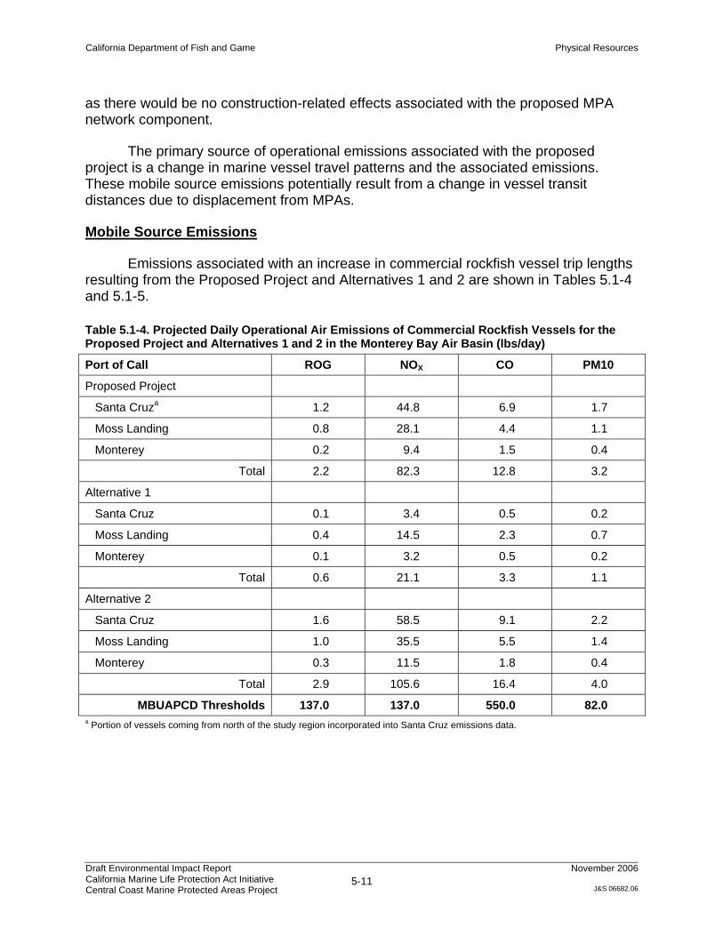
Emissions associated with an increase in commercial rockfish vessel trip lengths resulting from the Proposed Project and Alternatives 1 and 2 are shown in Tables 5.1-4 and 5.1-5.
Table 5.1-4. Projected Daily Operational Air Emissions of Commercial Rockfish Vessels for the Proposed Project and Alternatives 1 and 2 in the Monterey Bay Air Basin (lbs/day)
Port of Call ROG NOX CO PM10
Proposed Project
Santa Cruza 1.2 44.8 6.9 1.7
Moss Landing 0.8 28.1 4.4 1.1
Monterey 0.2 9.4 1.5 0.4
Total 2.2 82.3 12.8 3.2
Alternative 1
Santa Cruz 0.1 3.4 0.5 0.2
Moss Landing 0.4 14.5 2.3 0.7
Monterey 0.1 3.2 0.5 0.2
Total 0.6 21.1 3.3 1.1
Alternative 2
Santa Cruz 1.6 58.5 9.1 2.2
Moss Landing 1.0 35.5 5.5 1.4
Monterey 0.3 11.5 1.8 0.4
Total 2.9 105.6 16.4 4.0
MBUAPCD Thresholds 137.0 137.0 550.0 82.0 a Portion of vessels coming from north of the study region incorporated into Santa Cruz emissions data.

California Department of Fish and Game Physical Resources
Draft Environmental Impact Report California Marine Life Protection Act Initiative Central Coast Marine Protected Areas Project
5-12
November 2006
J&S 06682.06
Table 5.1-5. Projected Daily Operational Air Emissions of Commercial Rockfish Vessels for the Proposed Project and Alternatives 1 and 2 in the San Luis Obispo Air Basin (lbs/day)
Port of Call ROG NOX CO PM10
Proposed Project
Morro Bay 0.5 20.0 3.1 0.8
Port San Luisa 0.5 21.3 3.3 0.8
Total 1.0 41.3 6.4 1.6
Alternative 1
Morro Bay 0.2 9.4 1.5 0.4
Port San Luis 0.2 9.4 1.5 0.4
Total 0.4 18.8 3.0 0.8
Alternative 2
Morro Bay 0.6 22.9 3.6 0.9
Port San Luis 0.5 22.9 3.6 0.9
Total 1.1 45.8 7.2 1.8
SLOAPCD Thresholds 10 10 550 10 a Portion of vessels coming from south of the study region incorporated into Port San Luis emissions data.
Proposed Project: Significant Unavoidable Impact
As indicated in Tables 5.1-4 and 5.1-5, the Proposed Project’s operational emissions would be well below the MBUAPCD’s thresholds of significance and three of the four significance thresholds for the SLOAPCD; however, project-related operational emissions would exceed the SLOAPCD significance threshold for NOx emissions.
This impact also is considered a potential short-term impact of the Proposed Project. Long-term emissions are anticipated to be less than significant due to current trend of declining fleet numbers2, and the ARB’s ongoing statewide efforts on the regulation of harbor craft diesel engines.
While the scenario analyzed represents a reasonably foreseeable consequence, the SLOAPCD thresholds are very conservative compared to other air districts; therefore, the impact may be overstated and isn’t representative of the project as a whole, particularly when compared to the MBUAPCD NOx threshold of 137 lbs/day. It would take approximately a three-fold increase in the number of vessels in the study region’s southern half (approximately equal to 85% of the entire central coast study region commercial fishing fleet) to exceed the MBUAPCD emission thresholds.
2 Fishing block data over the past 25 years indicate a substantial decline in the number of fishing vessels operating within the central coast study region, from 1,803 vessels in 1981 to 612 vessels in 2005 (Ugoretz pers. comm.).

California Department of Fish and Game Physical Resources
Draft Environmental Impact Report California Marine Life Protection Act Initiative Central Coast Marine Protected Areas Project
5-13
November 2006
J&S 06682.06
Recreational fishing vessels also contribute to air emissions in the study region. While changes in transit patterns associated with the Proposed Project are anticipated to be limited due to the factors identified above (Section 5.1.3.1 Methodology), increased criteria pollutant emissions may occur on certain peak days when fishing conditions are favorable to recreational anglers. Emissions associated with recreational vessels also are subject to ARB regulation.
Mitigation - There are no mitigation measures that could reasonably be enforced by the Department that would reduce the short-term emissions impact to a less than significant level. Regulatory compliance authority lies with the ARB. Existing funded state programs such as the Carl Moyer Fund3 and pending advances in ARB diesel engine regulations for harbor craft would likely mitigate any potential long-term effects of the Proposed Project.
Alternative 1: Significant Unavoidable Impact
Emissions associated with Alternative 1 would be less than that of the Proposed Project, but would still exceed the SLOAPCD threshold for NOx, resulting in a significant unavoidable impact.
Mitigation - There are no mitigation measures that could reasonably be enforced by the California Fish and Game that would reduce this impact to a less than significant level. See mitigation discussion under the Proposed Project above.
Alternative 2: Significant Unavoidable Impact
Emissions associated with Alternative 2 would be somewhat greater than emissions resulting from the Proposed Project. As such, Alternative 2 also would exceed the SLOAPCD threshold for NOx, resulting in a significant unavoidable impact.
Mitigation - There are no mitigation measures that could reasonably be enforced by the California Fish and Game that would reduce this impact to a less than significant level. See mitigation discussion under the Proposed Project above.
Impact AIR-3: Exposure of Sensitive Receptors to Substantial Pollutant Concentrations
Certain residents, such as the very young, the elderly, and those suffering from certain illnesses or disabilities, are particularly sensitive to air pollution and are considered “sensitive receptors.” Examples of land uses where significant numbers of sensitive receptors are often found are schools, day care centers, parks, recreational areas, medical facilities, and rest homes and convalescent care facilities. Land use 3 The Carl Moyer Fund provides grants to reduce exhaust emissions from heavy-duty diesel engines. The fund is administered by the air districts in partnership with the ARB, and can be used to replace or retrofit old diesel engines with cleaner engines or emission control devices, and purchase new vehicles or equipment with acceptable emissions.

California Department of Fish and Game Physical Resources
Draft Environmental Impact Report California Marine Life Protection Act Initiative Central Coast Marine Protected Areas Project
5-14
November 2006
J&S 06682.06
conflicts can arise when sensitive receptors are located next to major sources of air pollutant emissions.
Proposed Project: No Impact
There are no new major sources of pollution associated with the Proposed Project that would affect sensitive receptors. Although the analysis of emissions shows the potential for an increase in NOx emissions and diesel particulate emissions, these emissions are speculative. Regardless, any emission increases would happen offshore, and not in close proximity to sensitive receptors. Therefore, the Proposed Project would not result in an impact to sensitive receptors.
Mitigation – No mitigation is required because there would be no impact.
Alternative 1: No Impact
Potential effects associated with Alternative 1 would be the same as those described above for the Proposed Project. Therefore, Alternative 1 would not result in an impact.
Mitigation – No mitigation is required because there would be no impact.
Alternative 2: No Impact
Potential effects associated with Alternative 2 would be the same as those described above for the Proposed Project. Therefore, Alternative 2 would not result in an impact.
Mitigation – No mitigation is required because there would be no impact.
Impact Air-4 Creation of Objectionable Odors Affecting a Substantial Number of People
Proposed Project: No Impact
The Proposed Project is not anticipated to generate any objectionable odors affecting a substantial number of people. As discussed above, the notion that offshore vessel traffic patterns would differ substantially from current patterns is speculative. Furthermore, offshore fishing vessels would not be anticipated to come into contact with a substantial number of people. Therefore, the Proposed Project would not result in an impact.
Mitigation – No mitigation is required because there would be no impact.

California Department of Fish and Game Physical Resources
Draft Environmental Impact Report California Marine Life Protection Act Initiative Central Coast Marine Protected Areas Project
5-15
November 2006
J&S 06682.06
Alternative 1: No Impact
Potential effects associated with Alternative 1 would be the same as those described above for the Proposed Project. Therefore, Alternative 1 would not result in an impact.
Mitigation – No mitigation is required because there would be no impact.
Alternative 2: No Impact
Potential effects associated with Alternative 2 would be the same as those described above for the Proposed Project. Therefore, Alternative 2 would not result in an impact.
Mitigation – No mitigation is required because there would be no impact.
5.2. Water Quality
5.2.1. Environmental Setting
The coastal marine waters of central California are strongly influenced by oceanographic and meteorological processes. The California current brings cool water from the north Pacific Ocean southward along the coast, contributing to the generally mild coastal air temperatures. Seasonally strong northwesterly winds drive coastal upwelling, in which deep, cold, nutrient-rich waters are brought to the surface in near-shore regions. This upwelling contributes to high coastal primary and secondary productivity, which support a very diverse biota.
Within the context of such broad oceanographic and meteorological conditions, it is generally recognized that land uses affect adjacent near-shore coastal water quality. Urbanized areas are often associated with treated wastewater discharges that can contain both domestic and industrial wastes. Storm runoff from urbanized and nonurbanized areas can contain a variety of pollutants, with agricultural watersheds often contributing loads of pesticides and nutrients to near-shore waters. Along the central California coast, there are eight permitted municipal wastewater discharges, some of which discharge wastewater from other municipalities and unincorporated areas. These discharges average 41 million gallons per day (mgd) (Table 5.2-1). There also are various discharges of seawater from university marine laboratories and the Monterey Bay Aquarium, as well as cooling water from two power plants—Moss Landing and Morro Bay. In addition to these discharges, freshwater flows from the San Lorenzo, Pajaro, Salinas, Carmel, Big Bur, Santa Maria, and Santa Ynez Rivers to coastal waters average more than 800 mgd.

California Department of Fish and Game Physical Resources
Draft Environmental Impact Report California Marine Life Protection Act Initiative Central Coast Marine Protected Areas Project
5-16
November 2006
J&S 06682.06
Table 5.2-1. Municipal Wastewater Discharges to Marine Waters along Central California Coast
Municipal Wastewater Source Daily Discharge (mgd)
City of Santa Cruz 13
City of Watsonville 8
Monterey Regional Water Pollution Control Agency 11
Carmel Area Wastewater District 1.3
Cambria Community Services District 1
San Simeon Acres Community Services District 0.2
City of Morro Bay and the Cayucos Sanitary District 2.1
South San Luis Obispo County Sanitation District 4.2
Total 41 Source: CCRWQB 1994.
As expected, water quality along the central California coast reflects the mix of
land uses and discharges in the region. Data on coastal water quality in the region typically come from studies or monitoring programs whose efforts are concentrated in the more urbanized areas or that target suspected problem areas. Consequently, there are relatively few data for water quality along the more pristine sections of coastline between Carmel and San Simeon, where water quality is expected to be good. Concentrations of contaminants in mussels measured by several programs over the past 28 years from 13 sites between Scott Creek (below Point Año Nuevo) and Point Conception show that chlorinated pesticides are higher near urbanized areas and the mouths of large agricultural watersheds. For example, dieldrin4 concentrations in mussels from Monterey Bay have exceeded two screening levels established to protect human health on numerous occasions (Chart 5.2-1). Moreover, data from the Central Coast Long-Term Environmental Assessment Network (CCLEAN)5 have shown that the Pajaro and Salinas Rivers are major sources of legacy pesticides6 and nutrients for near-shore waters of Monterey Bay. Concentrations of dieldrin in water collected from two sites 4 to 5 miles offshore in northern and southern Monterey Bay have shown that marine waters also sometimes exceed limits established by the California Ocean Plan (COP)7(State Water Board 2005) (Chart 5.2-2).
4 Dieldrin, an organochlorine compound, was a commonly used insecticide for crops like corn and cotton and for termite control. Its use was banned in the United States in 1984. 5 The CCLEAN focuses on water quality contaminant inputs and effects on near-shore water under the direction of the Central Coast Regional Water Quality Control Board (RWQCB). 6 Legacy pesticides are those that are no longer in use but persist in soils or water bodies. 7 The COP is a water quality plan adopted by the State Water Resources Control Board (State Water Board) that establishes water quality objectives for the ocean waters of California. The COP provides the basis for regulation of waste discharges to state waters.

California Department of Fish and Game Physical Resources
Draft Environmental Impact Report California Marine Life Protection Act Initiative Central Coast Marine Protected Areas Project
5-17
November 2006
J&S 06682.06
Chart 5.2-1. Comparison of Dieldrin Concentrations in Mussels from 13 Central California Sites with Two Screening Levels
Notes: EPA = U.S. Environmental Protection Agency
OEHHA = California Office of Environmental Health Hazard Assessment
The EPA has set screening values for fish or shellfish taken by recreational fishers. These screening values are based on the toxicity of different contaminants and assume an average fisher body weight of 70 kilograms (154 pounds equivalent) with consumption of 17.5 grams per day by recreational fishers.
The OEHHA has determined screening values using the same methods used by the EPA, except that it assumed a consumption rate of 21 grams per day of fish or shellfish. Mussel data are from the National Status and Trends Mussel Watch Program (http://www8.nos.noaa.gov/cit/nsandt/download/mw_monitoring.aspx), California State Mussel Watch (http://www.swrcb.ca.gov/programs/smw/index.html), and CCLEAN (http://www.cclean.org).
0
5
10
15
20
25
30P
oint
Con
cept
ion
Poi
nt S
an L
uis
San
Sim
eon
Car
mel
Riv
erB
each
Fans
hell
Ove
rlook
Love
rs P
oint
Pac
ific
Gro
ve
Mos
s La
ndin
g
Elk
horn
Slo
ugh
The
Hoo
k
Poi
nt S
anta
Cru
z
Lagu
na C
reek
Sco
tt C
reek
Sites
EPA Recreational Fishers OEHHA
S N

California Department of Fish and Game Physical Resources
Draft Environmental Impact Report California Marine Life Protection Act Initiative Central Coast Marine Protected Areas Project
5-18
November 2006
J&S 06682.06
Chart 5.2-2. Comparison of Dieldrin Concentrations in Water Samples Collected from Two Sites in Monterey Bay with California Ocean Plan Water Quality Limit
Another indication of water quality is whether a water body has been designated as impaired for a particular pollutant. Such designations are made in California by RWQCBs based on available data and established regulatory policies to guide implementation of corrective actions. Only two areas along the central California coast have been designated as impaired: 12 miles along the south coastline of Monterey Bay because of metals and pesticides, and 3.3 miles of coastline at Jalama Beach, approximately 5 miles north of Point Conception, because of fecal coliform bacteria (Figure 5.2-1).
Although water quality along the central California coast is generally good, freshwater runoff from the land has been implicated in infectious diseases affecting southern sea otters (Enhydra lutris nereis). Numerous fatal brain infections by the protozoan parasite Toxoplasma gondii have been recognized in southern sea otters from California (Thomas and Cole 1996; Cole et al. 2000). Miller et al. (2002) also documented specific evidence of coastal contamination of the marine ecosystem with T. gondii and extensive infection of southern sea otters along the central California coast. They found that otters sampled near areas of maximal freshwater runoff were approximately three times more likely to be seropositive to T. gondii than otters sampled
0
0.005
0.01
0.015
0.02
0.025
0.03
0.035
0.04
0.045
South Monterey Bay North Monterey BaySite
March 2004July 2004

California Department of Fish and Game Physical Resources
Draft Environmental Impact Report California Marine Life Protection Act Initiative Central Coast Marine Protected Areas Project
5-19
November 2006
J&S 06682.06
in areas of low flow. No association was found between seropositivity to T. gondii and human population density or exposure to sewage.
5.2.2. Regulatory Framework
Approximately two-thirds of the central California coastline falls within the Monterey Bay National Marine Sanctuary (MBNMS). The draft management plan for the MBNMS (NOAA 2006) includes a memorandum of agreement between eight federal, state, and regional agencies, including the Central Coast RWQCB, to develop an ecosystem-based water quality protection program for the MBNMS. The Central Coast RWQCB has developed a framework for partial fulfillment of this program called the Central Coast Ambient Monitoring Program. This multidisciplinary program includes sampling in watersheds that flow into coastal regions, in estuarine coastal confluences, and at coastal sites. The MBNMS also has developed action plans to address contamination from urban runoff, marinas and boating, agricultural and rural lands, and implementation of regional monitoring. The most applicable of these action plans to the Proposed Project is the plan for marinas and boating, which includes strategies for public education and outreach, technical training, bilge waste disposal and waste oil recovery, hazardous and toxic materials management, topside and haul-out vessel maintenance, underwater hull maintenance, and harbor pollution reduction progress review.
The Central Coast RWQCB has regulatory responsibility for water quality along the central California coast. Regulation of water quality occurs through provisions of the federal Clean Water Act and the state Porter-Cologne Water Quality Control Act. As part of their responsibility to protect water quality, RWQCBs grant discharge permits and enforce regulations that are designed to ensure sufficient water quality to protect beneficial uses designated by each RWQCB for every water body in its jurisdiction. The Central Coast RWQCB has designated 10 beneficial uses for coastal waters in central California (Table 5.2-2).
Each permit granted by the RWQCB to discharge waste to coastal waters includes limitations on the concentrations of contaminants that are allowed (i.e., effluent limits). Effluent limits are based on the modeled or measured dilution provided by each wastewater outfall so that contaminant concentrations will not exceed limits set by the COP to protect marine life and human health. The MBNMS also is given the opportunity to comment on every discharge permit issued by the RWQCB within the MBNMS.
There are six areas of special biological significance (ASBSs) (Table 5.2-3, Figure 5.2-1) in central California. ASBSs are under the jurisdiction of the SWRCB, are a subset of state water quality protection areas and are given special protections that include a prohibition against discharge of any waste, unless specifically allowed by an exception granted by the SWRCB. Recent actions by the SWRCB to enforce the prohibition of waste discharges to ASBSs have included the southern California Coastal Water Research Project, which inventoried freshwater flows to each ASBS (Table 5.2-

California Department of Fish and Game Physical Resources
Draft Environmental Impact Report California Marine Life Protection Act Initiative Central Coast Marine Protected Areas Project
5-20
November 2006
J&S 06682.06
3). For the purposes of this inventory, a discharge was defined as an anthropogenic8 source or location of a discernable volume of water that flows or was released directly into or immediately adjacent to the marine environment of an ASBS. An outlet was defined as any naturally occurring water body that drains into or immediately adjacent to an ASBS.
Table 5.2-3. Freshwater Flows to Areas of Special Biological Significance in Central California
Number of Each Flow Type
Area of Special Biological Significance Discharge Outlet Springs/Seeps
Año Nuevo 14 17 3
Pacific Grove 246 4 18
Carmel Bay 348 4 18
Point Lobos 16 39 1
Julia Pfeiffer Burns 25 3 0
Salmon Creek Coast 35 8 1 5.2.3. Impact Analysis
5.2.3.1. Methodology
Effects on water quality were assessed by evaluating the potential change in use patterns between proposed consumptive and recreational activities in the context of the potential for water quality degradation at sea or on the adjacent mainland. Several mechanisms for effects were considered. Fishing activity displacement and shifts in vessel traffic patterns were considered for their potential to create water quality impacts. Shifts in recreational, research, and other human activities were examined for their potential to accelerate mainland erosion from foot or off-highway vehicle traffic, deposition of trash, and contribution of water quality contaminants such as nutrients and coliform from human and animal waste. Other activities, such as the potential for increased vessel abandonment, were reviewed in the context of the potential for release of toxic substances in coastal waters.
5.2.3.2. Criteria for Determining Significance
Based on State CEQA Guidelines Appendix G and professional judgement, the Proposed Project would result in a significant impact if it would:
• violate any water quality standards or waste discharge requirements, or
• otherwise substantially degrade water quality.
8 Anthropogenic means derived from human activities.

Table 5.2-2. Designated Beneficial Uses of Coastal Waters in Central California Beneficial Use
Coastal Water Body REC 1 REC 2 IND NAV MAR SHELL COMM RARE ASBS WILD Pescadero Point to Point Año Nuevo X X X X X X X X X
Point Año Nuevo to Soquel Point X X X X X X X X
Point Año Nuevo and Island X X X X X X
Soquel Point to Salinas River X X X X X X X X X
Pacific Grove Marine Gardens X X X X X X X
Hopkins Marine Life Refuge X X X X X X X
Point Pinos to Point Piedras Blancas X X X X X X X
Carmel Bay X X X X X X X
Point Lobos State Reserve X X X X X X
Point Sur X X X X X X
Pfeiffer-Burns State Park X X X X X X
Ocean Area Surrounding Salmon Creek X X X X X
Point Piedras Blancas to Point Estero X X X X X X X X
Estero Bay X X X X X X X X X
Point Buchon to Point San Luis X X X X X X X X
Point San Luis to Point Sal X X X X X X X X X
Point Sal to Point Arguello X X X X X X X Notes: Water Contact Recreation (REC-1): Uses of water for recreational activities involving body contact with water, where ingestion of water is reasonably possible. Non-Contact Water Recreation (REC-2): Uses of water for recreational activities involving proximity to water, but not normally involving body contact with water, where ingestion of water is reasonably possible. Industrial Service Supply (IND): Uses of water for industrial activities that do not depend primarily on water quality. Navigation (NAV): Uses of water for shipping, travel, or other transportation by private, military, or commercial vessels. Marine Habitat (MAR): Uses of water that support marine ecosystems including, but not limited to, preservation or enhancement of marine habitats, vegetation such as kelp, fish, shellfish, or wildlife (e.g., marine mammals, shorebirds). Shellfish Harvesting (SHELL): Uses of water that support habitats suitable for the collection of filter-feeding shellfish (e.g., clams, oysters, and mussels) for human consumption, commercial, or sport purposes. Commercial and Sport Fishing (COMM): Uses of water for commercial or recreational collection of fish, shellfish, or other organisms including, but not limited to, uses involving organisms intended for human consumption or bait purposes. Rare, Threatened, or Endangered Species (RARE): Uses of water that support habitats necessary, at least in part, for the survival and successful maintenance of plant or animal species established under state or federal law as rare, threatened, or endangered. Areas of Special Biological Significance (ASBS): Areas designated by the State Water Resources Control Board as requiring protection of species or biological communities to the extent that alteration of natural water quality is undesirable. Wildlife Habitat (WILD): Uses of water that support terrestrial ecosystems including, but not limited to, preservation and enhancement of terrestrial habitats, vegetation, wildlife (e.g., mammals, birds, reptiles, amphibians, invertebrates), or wildlife water and food sources.

California Department of Fish and Game Physical Resources
Draft Environmental Impact Report California Marine Life Protection Act Initiative Central Coast Marine Protected Areas Project
5-21
November 2006
J&S 06682.06
5.2.3.3. Environmental Impacts
Establishing the proposed network component of MPAs would restrict fishing activity within specific portions of state waters, but it would not directly result in any changes in point- and non-point-source discharges within the central coast study region. It also would not result in land use changes that could affect discharges into the proposed MPA network component.
Impact WQ-1: Effects on Water Quality Standards and Waste Discharge Requirements
Proposed Project: No Impact
Establishing a network component of MPAs would not conflict with any aspect of the MBNMS’s water quality protection plan or any other water quality regulation. An MPA network component would not affect the implementation of any of the strategies in the MBNMS’s action plan to address contamination from boats and marinas. Moreover, creation of an MPA network component would be consistent with the wildlife and marine habitat beneficial uses designated by the Central Coast RWQCB for central California marine waters.
Creation of an MPA network component along the central California coast may result in the displacement of fishing vessels and activities to locations outside the boundaries of individual MPAs. As identified in Chapter 4, potential direct impacts resulting from such displacement include overcrowding of areas open to fishing, transiting farther to areas open to fishing, and abandonment of vessels because of economic hardship. Indirect impacts could be associated with vessels transiting farther to open fishing areas and vessel abandonment because of economic hardship because sunken, wrecked, or abandoned vessels often leak petroleum products and other hazardous materials into the water.
Although it cannot be accurately determined how individual fishermen will respond to an MPA network component, and given that fisherman are currently free to transit throughout state waters, it is not anticipated that longer transits would result in measurable changes in water quality beyond existing conditions or result in impairment of beneficial uses. Likely increased distances of travel potentially resulting from the implementation of an MPA network component would be limited at most to the along-shore span of any individual MPA, representing approximately 0.5 to 12 additional miles traveled, based on the alternative MPA network components currently being considered. Therefore, this would not create a water quality impact.
Mitigation – No mitigation is required because there would be no impact.

California Department of Fish and Game Physical Resources
Draft Environmental Impact Report California Marine Life Protection Act Initiative Central Coast Marine Protected Areas Project
5-22
November 2006
J&S 06682.06
Alternative 1: No Impact
Potential effects associated with Alternative 1 would be the same as those described above for the Proposed Project. Therefore, Alternative 1 would not result in an impact.
Mitigation – No mitigation is required because there would be no impact.
Alternative 2: No Impact
Potential effects associated with Alternative 2 would be the same as those described above for the Proposed Project. Therefore, Alternative 2 would not result in an impact.
Mitigation – No mitigation is required because there would be no impact.
Impact WQ-2: Vessel Abandonment Resulting from Displacement
As described in Chapter 4, some displacement of fishing effort may result from implementation of either the Proposed Project or alternatives. One of the potential impacts of displacement would be for individual commercial or recreational fishermen to leave the industry because of increased business costs, and potentially to abandon their vessel. Vessel abandonment has long been illegal in California, and the state legislature passed AB 716 in 2005, which included provisions allowing vessels with registration expired for more than 1 year to be removed from public waterways by law enforcement officers; reducing the length of time abandoned vessels must be held by law enforcement before being sold at auction from 90 to 60 days; doubling the maximum fine for vessel abandonment on public waterways to $3,000; and allowing the court to order violators to repay the enforcing agency for the actual cost of removing and disposing of a vessel. In the future, it is anticipated that the state will develop a pilot program to allow boat owners to turn in their older vessels to public agencies to reduce vessel abandonment.
Proposed Project: Less than Significant
Establishment of the proposed network component of MPAs would result in displacement of fishing effort, potentially causing individual fishermen to consider abandoning vessels as a result of individual economic losses. The amount of vessel abandonment of its rate of increase compared to existing conditions cannot be established because it is not possible to predict the decisions of individual fisherman. On a local scale, vessel abandonment may result in a water quality impact on individual harbors, depending on how much time passes before the abandonment is identified; the vessel’s location and hazardous content (e.g., fuels, oils); and how quickly the situation is remedied. However, vessel abandonment is illegal and the boat owner is held responsible for such actions.

California Department of Fish and Game Physical Resources
Draft Environmental Impact Report California Marine Life Protection Act Initiative Central Coast Marine Protected Areas Project
5-23
November 2006
J&S 06682.06
On a more regional scale, the potential for the Proposed Project to result in economic blight within the fishing industry, even at a localized level, leading to substantial losses and a potential corresponding substantial number of vessels to be abandoned, is speculative and is not supported by economic analysis completed to date (Wilen and Abbott 2006). Therefore, this impact would be less than significant.
Mitigation – No mitigation is required because impacts are not significant.
Alternative 1: Less than Significant
The potential for vessel abandonment associated with Alternative 1 would be somewhat less than described for the Proposed Project, as the potential displacement of fishing effort would be less that the Proposed Project. Therefore, this impact would be less than significant.
Mitigation – No mitigation is required because impacts are not significant.
Alternative 2: Less than Significant
The potential for vessel abandonment associated with Alternative 2 would be approximately the same as described for the Proposed Project, as potential fishing displacement effects would be comparable. Therefore, this impact would be less than significant.
Mitigation – No mitigation is required because impacts are not significant.
Impact WQ-3: Effects of Potential Shifts in Non-Consumptive Recreational Uses
Proposed Project: No Impact
Shifts in recreational, research, and other human activities can degrade water quality through accelerated mainland erosion from foot or off-highway vehicle traffic, deposition of trash, and contribution of water quality contaminants such as nutrients and coliform from human and animal waste, and vessel fuel and exhaust leakages. As discussed in section 7.5, the “hot spots” for nonconsumptive recreational uses in the study region include southern Monterey Bay (Monterey Breakwater, Lovers Point, and Monterey Coast Guard Launch Ramp), Carmel Bay, and the Big Sur coast (Point Lobos to Point Sur, including Garrapata State Park, Julia Pfeiffer Burns State Park, Mill Creek, and Jade Cove). The establishment of an MPA network component within the central coast study region would not result in a substantial redistribution of users to different access points. Therefore, related impacts on water quality associated with recreational users and facilities are not expected to increase over existing conditions. Existing effects would continue to be managed by agencies such as the SWRCB, RWQCBs, National Park Service, California Department of Parks and Recreation, and local counties and cities.

California Department of Fish and Game Physical Resources
Draft Environmental Impact Report California Marine Life Protection Act Initiative Central Coast Marine Protected Areas Project
5-24
November 2006
J&S 06682.06
Mitigation – No mitigation is required because there would be no impact.
Alternative 1: No Impact
Potential effects associated with Alternative 1 would be the same as those described above for the Proposed Project. Therefore, Alternative 1 would not result in an impact.
Mitigation – No mitigation is required because there would be no impact.
Alternative 2: No Impact
Potential effects associated with Alternative 2 would be the same as those described above for the Proposed Project. Therefore, Alternative 2 would not result in an impact.
Mitigation – No mitigation is required because there would be no impact.
Impact WQ-4: Beneficial Water Quality Effects
Proposed Project: Beneficial Impact
Many of the recommended SMRs or SMCAs are adjacent to, contain, or overlap existing ASBS. For example:
• The proposed Año Nuevo SMR and Greyhound Rock SMCA partially overlap the Año Nuevo ASBS.
• The Pacific Grove Marine Gardens Fish Refuge and Hopkins Marine Life Refuge ASBS are largely contained within the proposed Lovers Point SMR and Pacific Grove SMCA.
• The Carmel Bay ASBS is contained within the proposed Carmel Bay SMCA and Point Lobos SMR.
• The Point Lobos Ecological Reserve ASBS is contained within the proposed Point Lobos SMR.
It is possible that the designations of these and other MPAs within the study region would provide incentive to bring additional coastal waters under the special protections currently given ASBSs. This would be an indirect beneficial impact. If special protection also is given to water quality in the newly designated MPAs, the SWRCB or Central Coast RWQCB would be responsible for ensuring such protection. Parties such as local municipalities, the California Department of Transportation, and agricultural interests could be required to eliminate all dry-weather discharges and fund monitoring programs, as now required for dischargers into the current ASBS.

California Department of Fish and Game Physical Resources
Draft Environmental Impact Report California Marine Life Protection Act Initiative Central Coast Marine Protected Areas Project
5-25
November 2006
J&S 06682.06
Mitigation – No mitigation is required.
Alternative 1: Beneficial Impact
Potential effects associated with Alternative 1 would be the same as those described above for the Proposed Project. Therefore, Alternative 1 may result in a beneficial impact.
Mitigation – No mitigation is required.
Alternative 2: Beneficial Impact
Potential effects associated with Alternative 2 would be the same as those described above for the Proposed Project. Therefore, Alternative 2 may result in a beneficial impact.
Mitigation – No mitigation is required.
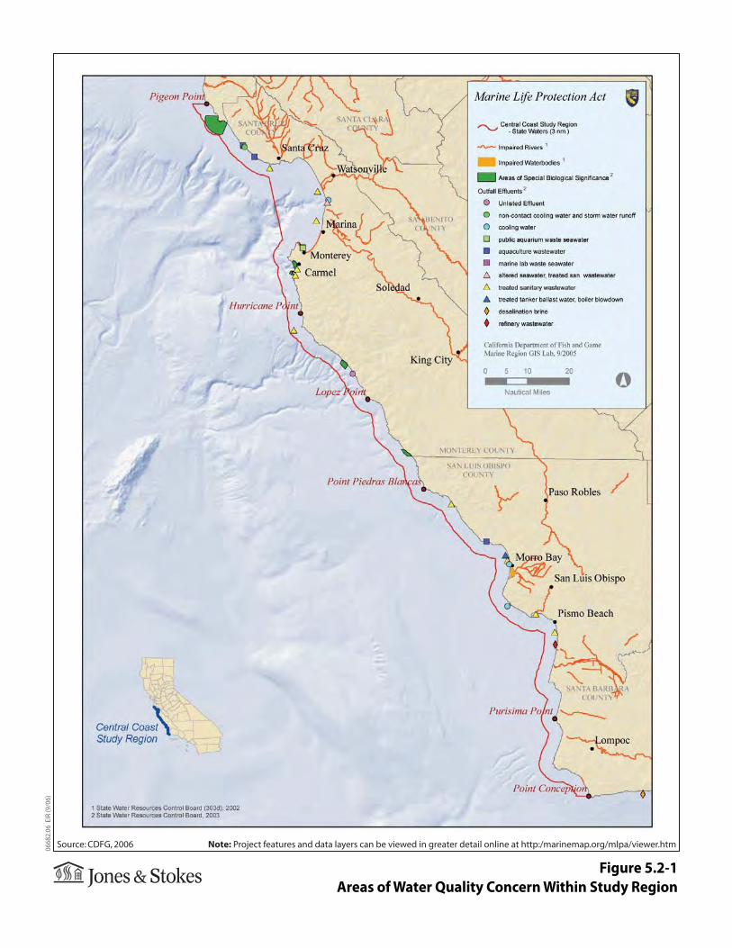
Figure 5.2-1Areas of Water Quality Concern Within Study Region
Myriad Pro RegularMyriad Pro ItalicMyriad Pro SemiboldMyriad Pro Semibold ItalicMyriad Pro BoldMyriad Pro Bold ItalicJensen Pro RegularJensen Pro Italic
0668
2.06
EIR
(9/0
6)
Source: CDFG, 2006 Note: Project features and data layers can be viewed in greater detail online at http:/marinemap.org/mlpa/viewer.htm


