Chapter 4 Convective Dynamics 4.5. Bright Bands, Bow Echoes and Mesoscale Convective Complexes...
30
Chapter 4 Convective Dynamics 4.5. Bright Bands, Bow Echoes and Mesoscale Convective Complexes Photographs © Todd Lindley
-
Upload
matteo-reeve -
Category
Documents
-
view
215 -
download
0
Transcript of Chapter 4 Convective Dynamics 4.5. Bright Bands, Bow Echoes and Mesoscale Convective Complexes...

Chapter 4 Convective Dynamics
4.5. Bright Bands, Bow Echoes and Mesoscale Convective Complexes
Photographs © Todd Lindley

Bright band associated with stratiform precipitation in a squall line system

Bright band associated with stratiform precipitation
• In stratiform precipitation regions, such as that in a mature squall line, a horizontal band of enhanced radar echo is often observed that is referred to as ‘bright band’.
• The bright band is located at the level of zero degree C – i.e., the melting level
• As the ice particles, snow flakes etc are half way through melting, their reflectivity is increased as they become enclosed by liquid water (water reflects radar beams more effectively than ice particles) while still keeping their size, resulting in a steep jump in radar echo
• As they completely melt into rain drops, their sizes are reduced resulting reduced echo level, therefore we observed a layer of significantly enhanced reflectivity
• Such observations of reflectivity can be used to study the microphysical properties of the clouds
• Sections 6.1.1-6.1.3 of Houze have detailed explanations of the microphysical processed involved.


Example of bright band associated with stratiform precipitation

Bow Echoes

Bow Echoes
• Bow echoes are relatively small (20-120 km long), bow-shaped systems of convective cells that are noted for producing long swaths of damaging surface winds.
• They are observed both as relatively isolated convective systems and as sub-structures within much larger convective systems.
• Bow echoes that develop within a squall line have been referred to as line echo wave patterns (LEWPs).

Bow Echo Conceptual Models• A bow echo has a well-recognized evolution starting as a strong isolated cell
or a small line of cells that evolves into a symmetric bow-shaped segment of cells over a period of a couple hours, and eventually into a comma-shaped echo over several hours.
• Cyclonic and anticyclonic line-end (or bookend) vortices are evident behind the northern and southern ends of the bow, respectively, in the early phases. This symmetric structure becomes more asymmetric during the comma echo phase when the cyclonic vortex begins to be dominant.
• A weak echo notch behind the core of the bow, referred to as a "rear-inflow notch" (RIN), often signifies the location of a strong rear-inflow jet. When the rear-inflow jet descends to the ground at the leading edge of the bow, it can create a swath of damaging surface winds. Weak tornadoes are also often observed just north of this surface jet core.

Bow Echo Conceptual Models• Bow echoes tend to propagate in the direction of the low-
level (0-3 km AGL) mean vertical wind shear vector, at a speed controlled by the propagation speed of the cold pool. Since the cold pools in bow echoes are often exceptionally strong, their propagation speed is often much faster than nearby convective cells or systems.
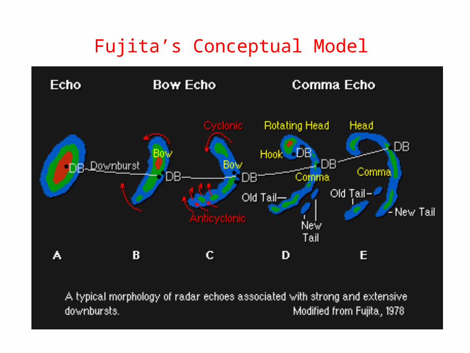
Fujita’s Conceptual Model

Bow Echo Vertical Cross Section
• A vertical cross section through the core of the bow depicts a strong, vertically erect updraft at the leading edge of the system, with a strong, elevated rear-inflow jet impinging to just behind the updraft region at mid-levels before descending rapidly to spread along the surface.
• Above the rear-inflow jet, the updraft current turns rapidly rearward, feeding into the stratiform precipitation region. The pressure field (not shown) is characterized by a strong mesohigh at the surface, associated with the cold pool, and a strong mesolow at mid-levels, just above the mesohigh.

Line-end Vortices in Bow Echoes
• Bow echoes’ extreme intensity is due in large part to their relatively small size. In particular, the smaller distance between the bookend vortices enhances the focusing effect on the mid-level flow between the vortices, which can significantly strengthen the rear-inflow jet.
• The descent of this enhanced rear-inflow jet to the surface tends to produce extreme surface winds

Rear Inflow Notch (RIN) Examples
A RIN apparent behind the bowing segment
A sharply defined RIN

Mid-Altitude Radial Convergence
(MARC)
MARC is a Doppler velocity signature that can serve as a precursor to the initial onset of damaging downburst winds in a squall line.
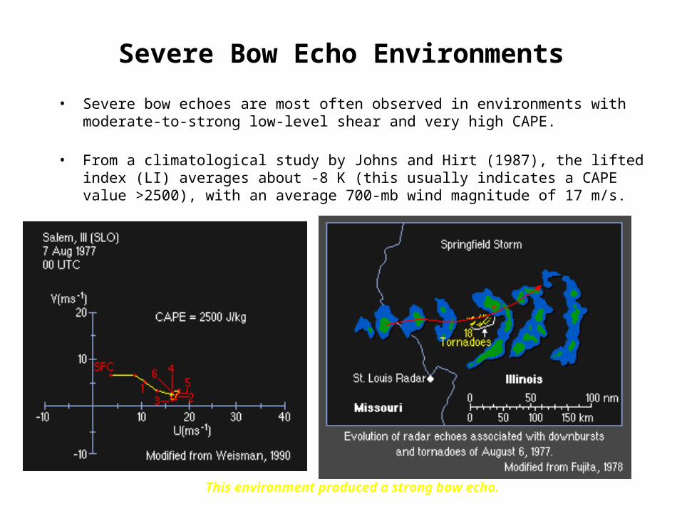
Severe Bow Echo Environments
• Severe bow echoes are most often observed in environments with moderate-to-strong low-level shear and very high CAPE.
• From a climatological study by Johns and Hirt (1987), the lifted index (LI) averages about -8 K (this usually indicates a CAPE value >2500), with an average 700-mb wind magnitude of 17 m/s.
This environment produced a strong bow echo.

Dynamics of Bow Echo
The updraft current is denoted by the thick double-lined flow vector, with the rear-inflow current in (c) and (d) denoted by the thick dashed vector. The shading denotes the surface cold pool. The thin, circular arrows depict the most significant sources of horizontal vorticity, which are either associated with the ambient shear or are generated within the convective system, as described in the text. Regions of lighter or heavier rainfall are indicated by the more sparsely or densely packed vertical lines, respectively. The scalloped line denotes the outline of the cloud (adapted in Weisman 1993 from Weisman 1992).

Four stages in the evolution of an idealized bow echo
• (a) An initial updraft leans downshear in response to the ambient vertical wind shear, which is shown on the right in the figures
• (b) The circulation generated by the storm-induced cold pool balances the ambient shear, and the system becomes upright.
• (c) The cold pool circulation overwhelms the ambient shear, and the system tilts upshear, producing a rear-inflow jet.
• (d) A new steady state is achieved whereby the circulation of the cold pool is balanced by both the ambient vertical wind shear and the elevated rear-inflow jet.
Typical Development and Evolution of Bow Echoes
Severe, long-lived bow echoes are produced in a restricted range of environmental conditions, including a convective available potential energy (CAPE) of at least 2000 m2 s-2 and vertical wind shears of at least 20 m s-1 over the lowest 2.5-5 km AGL.
The key structural features include a 40-100-km-long bow-shaped segment of convective cells, with a strong rear-inflow jet extending to the leading edge of the bow at 2-3 km AGL, and cyclonic and anticyclonic eddies (referred to as "bookend" vortices) on the northern and southern flanks of the bowed segment, respectively.

Typical Development and Evolution of Bow Echoes
This bow echo structure characteristically develops three to four hours into the lifetime of a convective system and may remain coherent for several hours.
The evolution of this coherent structure occurs systematically as the convectively produced cold pool strengthens over time, eventually producing a circulation that overwhelms the ambient shear.
This forces the convective cells to advect rearward above the cold air and weaken. The horizontal buoyancy gradients along the back edge of these rearward-advecting cells subsequently generate an elevated rear-inflow jet that extends to near the leading edge of the cold pool.
The circulation of this jet helps negate the circulation of the cold pool, reestablishing deep, forced lifting at the leading edge of the system.
This elevated rear-inflow jet is also enhanced through the development of bookend vortices.
Such vortices are produced at the ends of a convective line segment as vortex lines inherent in the ambient vertically sheared environment are first tilted upward by the convective updrafts and then tilted downward and stretched by the convective downdrafts.
The development of these features requires both large amounts of CAPE and strong vertical wind shear in the environment of these systems.

Origin of Bookend Vortices
Schematic depicting how a typical vortex tube contained within (westerly) environmental shear is deformed as it interacts with a convective cell (viewed from the southeast). Cylindrical arrows show the direction of cloud-relative airflow, and heavy solid lines represent vortex lines with the sense of rotation indicated by circular arrows. Shaded arrows represent the forcing influences that promote new updraft and downdraft growth. Vertical dashed lines denote regions of precipitation. (a) Initial stage: vortex tube loops into the vertical as it is swept into the updraft. (b) Splitting stage: downdraft forming between the splitting updraft cell tilts vortex tubes downward, producing two vortex pairs. The barbed line at the surface marks the boundary of the cold air spreading out beneath the storm (from Klemp 1987). The two vortices form at the end of the surface bow-shaped gust front.

Progressive and Serial Derechos
• A severe convective system may be composed of several bow echoes at the same time or a sequence of such features over time.
• If the cumulative impact of the severe wind from these events covers a wide enough and long enough path, the wind event is generically referred to as a “derecho”.
• Johns and Hirt (1987) have classified derechos as either progressive or serial.
• Progressive Derechos are usually characterized by a single bow-shaped system that propagates north of, but parallel to, a weak east-west oriented stationary boundary.
• Serial Derechos are composed of a series of bow-echo features along a squall line, usually located within the warm sector of a synoptic-scale cyclone.

Bow Echoes Summary
• Bow echoes are typically 20-120 km long bow-shaped systems of convective cells that are noted for producing long swaths of damaging surface winds
• Bow echoes may occur as either isolated convective systems or as part of much larger convective systems such as squall lines
• The line-end vortices associated with bow echoes are often referred to as bookend vortices
• A weak echo notch behind the core of the bow, referred to as a rear-inflow notch (RIN), often signifies the location of a strong rear-inflow jet
• Bow echoes tend to propagate in the direction of the mean low-level vertical wind shear vector at a speed controlled by the cold pool propagation
• A vertical cross section in the core of the bow echo reveals a strong, vertically erect updraft at the leading edge of the system; a strong, elevated rear-inflow jet impinging to just behind the updraft region before descending rapidly to the surface; and a system-scale updraft that turns rapidly rearward, feeding into the stratiform precipitation region

Bow Echoes Summary
• Bow echoes often generate intense winds when the close proximity of the line-end vortices acts to strengthen the rear-inflow jet, leading to widespread, potentially damaging winds at the surface
• If the cumulative impact of the severe wind from one or more bow echoes covers a wide enough and long enough path, the event is referred to as a derecho
• Progressive derechos are characterized by a single bow-shaped system that propagates north of and parallel to a weak east-west oriented stationary boundary
• Serial derechos are composed of a series of bow-echo features along a squall line, usually located within the warm sector of a synoptic-scale cyclone
• Severe bow echoes are most often observed in environments with moderate-to-strong low-level shear and very high CAPE
• Bow echo and supercell environments overlap, with bow echoes often characterizing the later stages of a supercell event


A numerical Simulation of a squall line with
a series of embedded bow
echoes

Mesoscale Convective Complex (MCC)

Mesoscale Convective Complex (MCC)
• Mesoscale convective complexes (MCCs) represent a larger form of mesoscale convective system (MCS) organization.
• A system is identified as an MCC based on its characteristics as depicted on IR satellite imagery.
• The physical characteristics include a general cloud shield with continuously low IR temperatures less than -32 C over an area 100,000 km2, with an interior cold cloud region with temperatures less than -52° C having an area 50,000 km2.
• MCCs often last for 6-12 h, and are especially known for producing heavy amounts of rain, although severe winds, hail, and tornadoes can also occur during the early phases of MCC evolution.


MCC Evolution
• During the early phases of evolution, the convective structures that make up an MCC may include multiple squall lines, bow echoes, or isolated convective cells, each evolving through its own lifecycle, with each system contributing to the expanding MCC anvil as depicted on a satellite image.
• During the later stages of evolution, however, a large stratiform precipitation region dominates the MCC, as it does in the later stages of squall line evolution.

MCC Evolution• The flow field in the later stages of an MCC is
characterized by divergent, anticyclonic outflow near the surface and aloft within the anvil, with convergent cyclonic flow at mid-levels.
• Like the northern line-end vortices of squall lines that sometimes grow quite large, this mid-level cyclonic flow is often referred to as a mesoscale convective vortex (MCV).
• MCCs are most often observed at night, in areas in which the boundary layer is stable. The source of energy for such systems is often found in an elevated layer above the boundary layer, north of a weak surface warm front.
• Observational studies suggest that MCC structure and evolution is more dependent on interactions with large-scale forcing features than the boundary-layer-based mesoscale convective systems (MCSs) such as squall lines and bow echoes.