CHAPTER 4 APPENDICES - content.gov.mb.ca
43
PROJECT 4 – ALL-SEASON ROAD ENVIRONMENTAL IMPACT STATEMENT CHAPTER 4 APPENDICES
Transcript of CHAPTER 4 APPENDICES - content.gov.mb.ca
PROJECT 4 – ALL-SEASON ROAD ENVIRONMENTAL IMPACT STATEMENT
Page 4-40
CHAPTER 4 APPENDICES
PROJECT 4 – ALL-SEASON ROAD ENVIRONMENTAL IMPACT STATEMENT
Appendix 4-1
Round 1 APEP Questions and
Comments
PROJECT 4 – ALL-SEASON ROAD ENVIRONMENTAL IMPACT STATEMENT
Appendix 4-1 Page 1
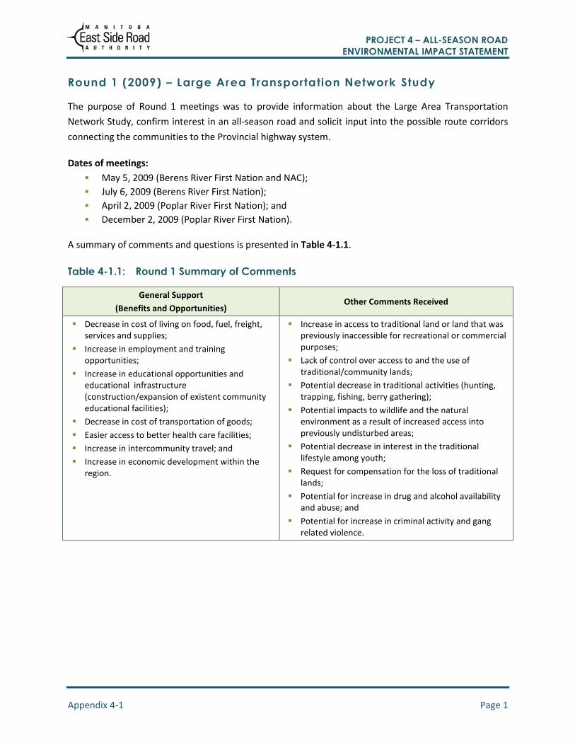
Round 1 (2009) – Large Area Transportation Network Study
The purpose of Round 1 meetings was to provide information about the Large Area Transportation
Network Study, confirm interest in an all-season road and solicit input into the possible route corridors
connecting the communities to the Provincial highway system.
Dates of meetings:
May 5, 2009 (Berens River First Nation and NAC);
July 6, 2009 (Berens River First Nation);
April 2, 2009 (Poplar River First Nation); and
December 2, 2009 (Poplar River First Nation).
A summary of comments and questions is presented in Table 4-1.1.
Table 4-1.1: Round 1 Summary of Comments
General Support
(Benefits and Opportunities) Other Comments Received
Decrease in cost of living on food, fuel, freight, services and supplies;
Increase in employment and training opportunities;
Increase in educational opportunities and educational infrastructure (construction/expansion of existent community educational facilities);
Decrease in cost of transportation of goods;
Easier access to better health care facilities;
Increase in intercommunity travel; and
Increase in economic development within the region.
Increase in access to traditional land or land that was previously inaccessible for recreational or commercial purposes;
Lack of control over access to and the use of traditional/community lands;
Potential decrease in traditional activities (hunting, trapping, fishing, berry gathering);
Potential impacts to wildlife and the natural environment as a result of increased access into previously undisturbed areas;
Potential decrease in interest in the traditional lifestyle among youth;
Request for compensation for the loss of traditional lands;
Potential for increase in drug and alcohol availability and abuse; and
Potential for increase in criminal activity and gang related violence.

PROJECT 4 – ALL-SEASON ROAD ENVIRONMENTAL IMPACT STATEMENT
Appendix 4-2
Round 2 APEP Questions and
Comments
PROJECT 4 – ALL-SEASON ROAD ENVIRONMENTAL IMPACT STATEMENT
Appendix 4-2 Page 1
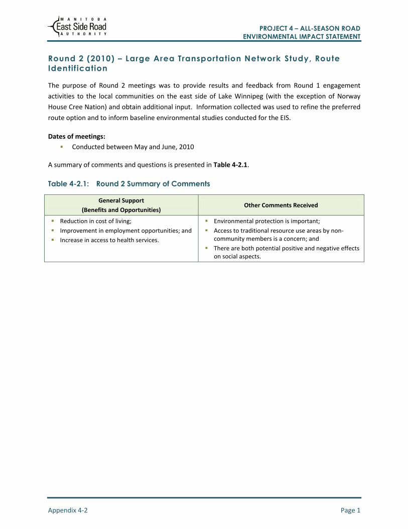
Round 2 (2010) – Large Area Transportation Network Study, Route
Identif ication
The purpose of Round 2 meetings was to provide results and feedback from Round 1 engagement
activities to the local communities on the east side of Lake Winnipeg (with the exception of Norway
House Cree Nation) and obtain additional input. Information collected was used to refine the preferred
route option and to inform baseline environmental studies conducted for the EIS.
Dates of meetings:
Conducted between May and June, 2010
A summary of comments and questions is presented in Table 4-2.1.
Table 4-2.1: Round 2 Summary of Comments
General Support
(Benefits and Opportunities) Other Comments Received
Reduction in cost of living;
Improvement in employment opportunities; and
Increase in access to health services.
Environmental protection is important;
Access to traditional resource use areas by non-community members is a concern; and
There are both potential positive and negative effects on social aspects.

PROJECT 4 – ALL-SEASON ROAD ENVIRONMENTAL IMPACT STATEMENT
Appendix 4-3
Round 3 APEP Meeting Information
PROJECT 4 – ALL-SEASON ROAD ENVIRONMENTAL IMPACT STATEMENT
Appendix 4-3 Page 1
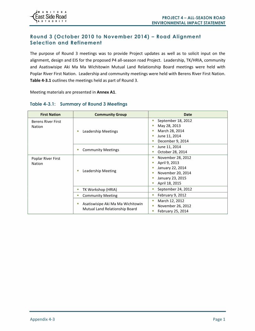
Round 3 (October 2010 to November 2014) – Road Alignment
Selection and Refinement
The purpose of Round 3 meetings was to provide Project updates as well as to solicit input on the
alignment, design and EIS for the proposed P4 all-season road Project. Leadership, TK/HRIA, community
and Asatiswisipe Aki Ma Ma Wichitowin Mutual Land Relationship Board meetings were held with
Poplar River First Nation. Leadership and community meetings were held with Berens River First Nation.
Table 4-3.1 outlines the meetings held as part of Round 3.
Meeting materials are presented in Annex A1.
Table 4-3.1: Summary of Round 3 Meetings
First Nation Community Group Date
Berens River First Nation
Leadership Meetings
September 18, 2012 May 28, 2013 March 28, 2014 June 11, 2014 December 9, 2014
Community Meetings June 11, 2014 October 28, 2014
Poplar River First Nation
Leadership Meeting
November 28, 2012 April 9, 2013 January 22, 2014 November 20, 2014 January 23, 2015 April 18, 2015
TK Workshop (HRIA) September 24, 2012
Community Meeting February 9, 2012
Asatiswisipe Aki Ma Ma Wichitowin Mutual Land Relationship Board
March 12, 2012 November 26, 2012 February 25, 2014

PROJECT 4 – ALL-SEASON ROAD ENVIRONMENTAL IMPACT STATEMENT
Appendix 4-4
Round 4 APEP Questions and
Comments

PROJECT 4 – ALL-SEASON ROAD ENVIRONMENTAL IMPACT STATEMENT
Appendix 4-4 Page 1
Round 4 (Apri l 2015) – EIA and Project Overview
The purpose of Round 4 meetings was to provide Project information, review the options considered,
summarize previous community engagement events, discuss the EIA and baseline data collection,
discuss VCs and obtain feedback and input on the EIA process and VC selection. Input from these
meetings helped to identify VCs to be assessed as part of the environmental assessment and to further
refine the Project alignment and design.
Dates of meetings:
April 30, 2015 (Berens River First Nation and NAC); and
April 23, 2015 (Poplar River First Nation).
Meeting materials are presented in Annex A. A summary of comments and questions from Round 4 is
provided in Tables 4-4.1 to 4-4.3.
Table 4-4.1: Round 4 Summary of Comments – Berens River First Nation and NAC
Topic Comments
Overall Project Boat and snow mobile launch points should not be provided at river and stream crossings.
Vegetation No comments
Wildlife Moose are very important to the community, and should be a VC;
The area along the North Etomami River just north of the Berens River junction is a community sensitive habitat area, and should be avoided. Happy to see the P4-ASR has been moved away from this area based on community feedback;
Trappers to be notified when and where construction will occur so that traps in the area can be relocated;
Wildlife movements: starting to see more wolverines coming into the community; and
Caribou run north and south far to the east of the road alignment after freeze up in the fall and spring.
Aquatic Environment
The protection of fish spawning areas is important. Fish should still be able to travel upstream, and fish runs should not be restricted; and
Red sucker fish are an important catch.
Heritage, Culture, and Tradition
No comments.
Table 4-4.2: Round 4 Summary of Comments – Poplar River First Nation
Topic Comments
Overall Project Questions related to federal funding for further road work;
Questions on the type of crossing for the stream from Many Bays Lake. Bridge or culvert?
A blessing should take place before construction activities
Vegetation No comments.
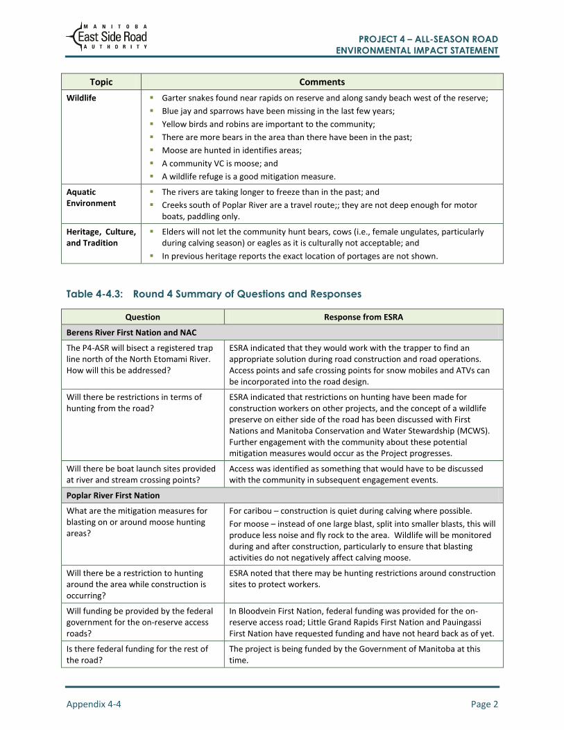
PROJECT 4 – ALL-SEASON ROAD ENVIRONMENTAL IMPACT STATEMENT
Appendix 4-4 Page 2
Topic Comments
Wildlife Garter snakes found near rapids on reserve and along sandy beach west of the reserve;
Blue jay and sparrows have been missing in the last few years;
Yellow birds and robins are important to the community;
There are more bears in the area than there have been in the past;
Moose are hunted in identifies areas;
A community VC is moose; and
A wildlife refuge is a good mitigation measure.
Aquatic Environment
The rivers are taking longer to freeze than in the past; and
Creeks south of Poplar River are a travel route;; they are not deep enough for motor boats, paddling only.
Heritage, Culture, and Tradition
Elders will not let the community hunt bears, cows (i.e., female ungulates, particularly during calving season) or eagles as it is culturally not acceptable; and
In previous heritage reports the exact location of portages are not shown.
Table 4-4.3: Round 4 Summary of Questions and Responses
Question Response from ESRA
Berens River First Nation and NAC
The P4-ASR will bisect a registered trap line north of the North Etomami River. How will this be addressed?
ESRA indicated that they would work with the trapper to find an appropriate solution during road construction and road operations. Access points and safe crossing points for snow mobiles and ATVs can be incorporated into the road design.
Will there be restrictions in terms of hunting from the road?
ESRA indicated that restrictions on hunting have been made for construction workers on other projects, and the concept of a wildlife preserve on either side of the road has been discussed with First Nations and Manitoba Conservation and Water Stewardship (MCWS). Further engagement with the community about these potential mitigation measures would occur as the Project progresses.
Will there be boat launch sites provided at river and stream crossing points?
Access was identified as something that would have to be discussed with the community in subsequent engagement events.
Poplar River First Nation
What are the mitigation measures for blasting on or around moose hunting areas?
For caribou – construction is quiet during calving where possible.
For moose – instead of one large blast, split into smaller blasts, this will produce less noise and fly rock to the area. Wildlife will be monitored during and after construction, particularly to ensure that blasting activities do not negatively affect calving moose.
Will there be a restriction to hunting around the area while construction is occurring?
ESRA noted that there may be hunting restrictions around construction sites to protect workers.
Will funding be provided by the federal government for the on-reserve access roads?
In Bloodvein First Nation, federal funding was provided for the on-reserve access road; Little Grand Rapids First Nation and Pauingassi First Nation have requested funding and have not heard back as of yet.
Is there federal funding for the rest of the road?
The project is being funded by the Government of Manitoba at this time.

PROJECT 4 – ALL-SEASON ROAD ENVIRONMENTAL IMPACT STATEMENT
Appendix 4-4 Page 3
Question Response from ESRA
Have equalization culvert locations been identified?
These will be finalized during the detailed design phase which has not yet started.
Are bridges an option for smaller creeks that people use for navigation?
The TK exercises are to identify travel requirements as well as portages. TK will be used to better understand Poplar River First Nation’s use of the landscape and will factor into design of watercrossings structures.
How is TK information used? TK information collected is used for design, project planning, environmental studies and the EIA.

PROJECT 4 – ALL-SEASON ROAD ENVIRONMENTAL IMPACT STATEMENT
Appendix 4-5
Round 5 APEP Questions and
Comments
PROJECT 4 – ALL-SEASON ROAD ENVIRONMENTAL IMPACT STATEMENT
Appendix 4-5 Page 1
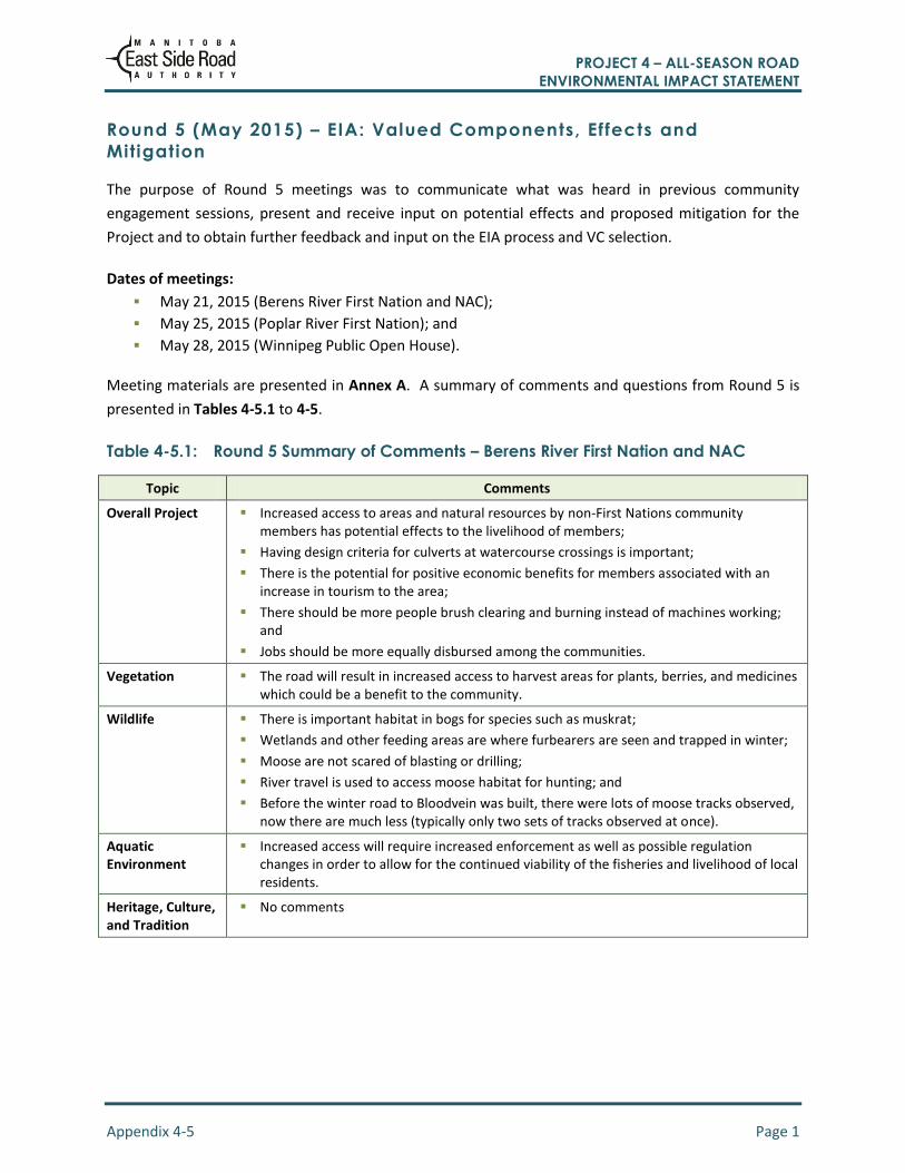
Round 5 (May 2015) – EIA: Valued Components, Effects and
Mitigation
The purpose of Round 5 meetings was to communicate what was heard in previous community
engagement sessions, present and receive input on potential effects and proposed mitigation for the
Project and to obtain further feedback and input on the EIA process and VC selection.
Dates of meetings:
May 21, 2015 (Berens River First Nation and NAC);
May 25, 2015 (Poplar River First Nation); and
May 28, 2015 (Winnipeg Public Open House).
Meeting materials are presented in Annex A. A summary of comments and questions from Round 5 is
presented in Tables 4-5.1 to 4-5.
Table 4-5.1: Round 5 Summary of Comments – Berens River First Nation and NAC
Topic Comments
Overall Project Increased access to areas and natural resources by non-First Nations community members has potential effects to the livelihood of members;
Having design criteria for culverts at watercourse crossings is important;
There is the potential for positive economic benefits for members associated with an increase in tourism to the area;
There should be more people brush clearing and burning instead of machines working; and
Jobs should be more equally disbursed among the communities.
Vegetation The road will result in increased access to harvest areas for plants, berries, and medicines which could be a benefit to the community.
Wildlife There is important habitat in bogs for species such as muskrat;
Wetlands and other feeding areas are where furbearers are seen and trapped in winter;
Moose are not scared of blasting or drilling;
River travel is used to access moose habitat for hunting; and
Before the winter road to Bloodvein was built, there were lots of moose tracks observed, now there are much less (typically only two sets of tracks observed at once).
Aquatic Environment
Increased access will require increased enforcement as well as possible regulation changes in order to allow for the continued viability of the fisheries and livelihood of local residents.
Heritage, Culture, and Tradition
No comments
PROJECT 4 – ALL-SEASON ROAD ENVIRONMENTAL IMPACT STATEMENT
Appendix 4-5 Page 2
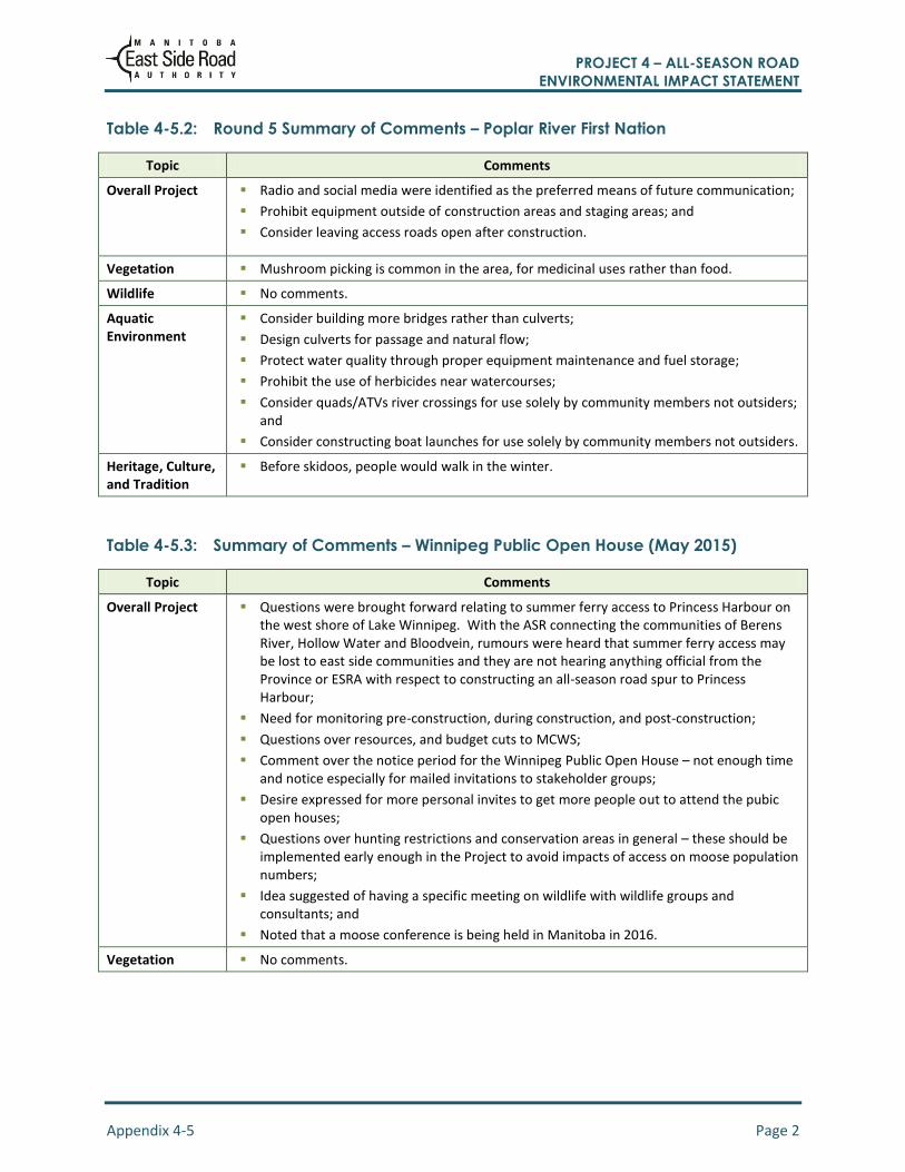
Table 4-5.2: Round 5 Summary of Comments – Poplar River First Nation
Topic Comments
Overall Project Radio and social media were identified as the preferred means of future communication;
Prohibit equipment outside of construction areas and staging areas; and
Consider leaving access roads open after construction.
Vegetation Mushroom picking is common in the area, for medicinal uses rather than food.
Wildlife No comments.
Aquatic Environment
Consider building more bridges rather than culverts;
Design culverts for passage and natural flow;
Protect water quality through proper equipment maintenance and fuel storage;
Prohibit the use of herbicides near watercourses;
Consider quads/ATVs river crossings for use solely by community members not outsiders; and
Consider constructing boat launches for use solely by community members not outsiders.
Heritage, Culture, and Tradition
Before skidoos, people would walk in the winter.
Table 4-5.3: Summary of Comments – Winnipeg Public Open House (May 2015)
Topic Comments
Overall Project Questions were brought forward relating to summer ferry access to Princess Harbour on the west shore of Lake Winnipeg. With the ASR connecting the communities of Berens River, Hollow Water and Bloodvein, rumours were heard that summer ferry access may be lost to east side communities and they are not hearing anything official from the Province or ESRA with respect to constructing an all-season road spur to Princess Harbour;
Need for monitoring pre-construction, during construction, and post-construction;
Questions over resources, and budget cuts to MCWS;
Comment over the notice period for the Winnipeg Public Open House – not enough time and notice especially for mailed invitations to stakeholder groups;
Desire expressed for more personal invites to get more people out to attend the pubic open houses;
Questions over hunting restrictions and conservation areas in general – these should be implemented early enough in the Project to avoid impacts of access on moose population numbers;
Idea suggested of having a specific meeting on wildlife with wildlife groups and consultants; and
Noted that a moose conference is being held in Manitoba in 2016.
Vegetation No comments.

PROJECT 4 – ALL-SEASON ROAD ENVIRONMENTAL IMPACT STATEMENT
Appendix 4-5 Page 3
Topic Comments
Wildlife Identification of caribou and particularly moose as being important to the communities and stakeholder; and
Opinion that moose and caribou numbers in the southeast side area have been declining significantly in recent years in some areas south of the Project. With the P1 ASR construction increased access could accelerate the decline in moose numbers to low levels at which point the population is no longer viable.
Aquatic Environment
No comments.
Heritage, Culture, and Tradition
No comments.
Table 4-5.4: Round 5 Summary of Questions and Responses
Question Response from ESRA
Berens River First Nation and NAC
It was noted that with increased access, outsiders may come in and fish on the rivers, taking profits and livelihood away from existing local fishers. How can this be prevented and/or mitigated?
ESRA discussed the following mitigation measures:
Avoiding the construction of boat launch sites.
Enforcement. This mitigation measure is outside of ESRA’s authority or ability to implement.
Quotas large enough to be viable and with no individual holding more than one quota. This mitigation measure is outside of ESRA’s authority or ability to implement.
Hydro-controlled lake levels were noted, and all culverts should be designed for 100-year flood levels.
ESRA indicated that culverts are designed for 100-year flood levels, and it was noted that lake levels are not within ESRA’s authority, or part of this Project.
With increased tourism potential from ASR construction, Berens River First Nation members building cabins (or other accommodations) is positive as the First Nation benefits. Benefits should stream to the community rather than outsiders.
ESRA indicated that socio-economic impacts, as a result of biophysical effects, of the proposed all-season road would be examined as part of the EIA. A restriction on who can build cabins is beyond ESRA’s authority.
When is ESRA going to start the Project?
ESRA indicated that they need to complete the EIA. Construction will then start after government approvals are received, expected to be December 2016.
Is this consultation? No, this is considered engagement on the Project.
Has the Boreal UNESCO Site been granted?
The Pimachiowin Aki and communities are still working on it. ESRA indicated that up to date information can be found on their website http://www.pimachiowinaki.org/about-us.
When will construction for P4 be complete?
ESRA indicated that it hinges on government budgets. Contracts will likely be 10 km in length with both communities working toward each other. Anticipate that it will take approximately 3 years to finish.
Where is the P4-ASR going to connect?
ESRA indicated that it will connect at English Rapids Road.

PROJECT 4 – ALL-SEASON ROAD ENVIRONMENTAL IMPACT STATEMENT
Appendix 4-5 Page 4
Question Response from ESRA
Who builds the road? Community owned and privately owned construction firms will build the road. It will hire additional, local people.
Is there any thought of compensation to the subcontractor of the winter road system when the winter road is no longer needed?
ESRA indicated that the skills used to construct the winter road are transferrable to the maintenance of the P4-ASR.
Who has contracts on P1? In Berens River First Nation’s traditional territory, Pigeon River Contracting (PRC) currently has the contract to construct portions of the road from Berens River to PR 304. ESRA explained the differences between PRC and Mimiweesipi (both owned by Berens River First Nation). PRC is the Berens River First Nation construction company that ESRA is working with on Community Benefit Agreement (CBA) contracts.
Why does ESRA have a Winnipeg Meeting?
ESRA indicated that the purpose of the Winnipeg Public Open House is to allow off-reserve Band Members, and other stakeholders (MMF, Eastern Region Caribou etc.) to provide input into the Project.
Poplar River First Nation
Some zebra mussels have been found in the south basin of Lake Winnipeg. Have any been found around Poplar River yet?
No, not at this time.
How long do culverts last? They can last between 30-50 years, dependent on coating (aluminized or galvanized) and the pH levels of water. ESRA uses aluminized coating which is longer lasting.
Do culverts impede fish passage? No. Culverts are designed for 1:100 year flood and embedded when installed to provide fish passage.
How can ESRA include Elders in this process?
ESRA indicated that the Elders will be able to review the proposed road alignment ahead of time as part of the construction activities.
How is TK information used? ESRA to provide an overview of what TK information will be used in the EIA and what will not be included. ESRA indicated that some information (e.g. summary of questions asked) can be used in the document. Other information related to local land use data is sensitive and should not be included in the EIA as it is a public document.
ESRA also noted that in the public open house in Winnipeg there will be an explanation of how TK information is used.
Winnipeg Public Open House
Will ferry access to Princess Harbour be maintained upon completion of the all-season road?
ESRA indicated that it was outside of the scope of the Project and falls under P1 Project area. They would follow up in regards to that issue.
Will there be monitoring of wildlife and other resources during the construction process?
ESRA indicated that there would be monitoring occurring throughout the construction process.
Baseline wildlife studies and the Trapper Program are occurring to inform the EIA and project design.
There will be a meeting specifically with the wildlife groups.
PROJECT 4 – ALL-SEASON ROAD ENVIRONMENTAL IMPACT STATEMENT
Appendix 4-5 Page 5
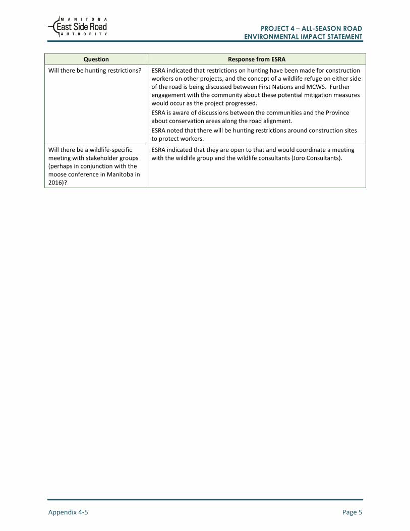
Question Response from ESRA
Will there be hunting restrictions? ESRA indicated that restrictions on hunting have been made for construction workers on other projects, and the concept of a wildlife refuge on either side of the road is being discussed between First Nations and MCWS. Further engagement with the community about these potential mitigation measures would occur as the project progressed.
ESRA is aware of discussions between the communities and the Province about conservation areas along the road alignment.
ESRA noted that there will be hunting restrictions around construction sites to protect workers.
Will there be a wildlife-specific meeting with stakeholder groups (perhaps in conjunction with the moose conference in Manitoba in 2016)?
ESRA indicated that they are open to that and would coordinate a meeting with the wildlife group and the wildlife consultants (Joro Consultants).
PROJECT 4 – ALL-SEASON ROAD ENVIRONMENTAL IMPACT STATEMENT
Appendix 4-6
Round 6 APEP Questions and
Comments
PROJECT 4 – ALL-SEASON ROAD ENVIRONMENTAL IMPACT STATEMENT
Appendix 4-6 Page 1
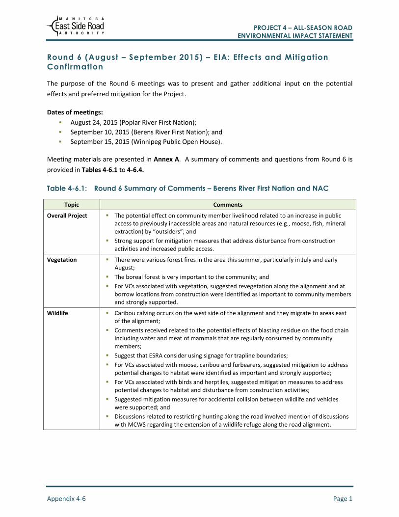
Round 6 (August – September 2015) – EIA: Effects and Mitigation
Confirmation
The purpose of the Round 6 meetings was to present and gather additional input on the potential
effects and preferred mitigation for the Project.
Dates of meetings:
August 24, 2015 (Poplar River First Nation);
September 10, 2015 (Berens River First Nation); and
September 15, 2015 (Winnipeg Public Open House).
Meeting materials are presented in Annex A. A summary of comments and questions from Round 6 is
provided in Tables 4-6.1 to 4-6.4.
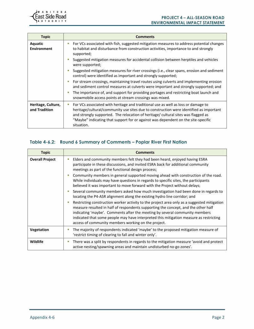
Table 4-6.1: Round 6 Summary of Comments – Berens River First Nation and NAC
Topic Comments
Overall Project The potential effect on community member livelihood related to an increase in public access to previously inaccessible areas and natural resources (e.g., moose, fish, mineral extraction) by “outsiders”; and
Strong support for mitigation measures that address disturbance from construction activities and increased public access.
Vegetation There were various forest fires in the area this summer, particularly in July and early August;
The boreal forest is very important to the community; and
For VCs associated with vegetation, suggested revegetation along the alignment and at borrow locations from construction were identified as important to community members and strongly supported.
Wildlife Caribou calving occurs on the west side of the alignment and they migrate to areas east of the alignment;
Comments received related to the potential effects of blasting residue on the food chain including water and meat of mammals that are regularly consumed by community members;
Suggest that ESRA consider using signage for trapline boundaries;
For VCs associated with moose, caribou and furbearers, suggested mitigation to address potential changes to habitat were identified as important and strongly supported;
For VCs associated with birds and herptiles, suggested mitigation measures to address potential changes to habitat and disturbance from construction activities;
Suggested mitigation measures for accidental collision between wildlife and vehicles were supported; and
Discussions related to restricting hunting along the road involved mention of discussions with MCWS regarding the extension of a wildlife refuge along the road alignment.
PROJECT 4 – ALL-SEASON ROAD ENVIRONMENTAL IMPACT STATEMENT
Appendix 4-6 Page 2
Topic Comments
Aquatic Environment
For VCs associated with fish, suggested mitigation measures to address potential changes to habitat and disturbance from construction activities, importance to and strongly supported;
Suggested mitigation measures for accidental collision between herptiles and vehicles were supported;
Suggested mitigation measures for river crossings (i.e., clear spans, erosion and sediment control) were identified as important and strongly supported;
For stream crossings, maintaining travel routes using culverts and implementing erosion and sediment control measures at culverts were important and strongly supported; and
The importance of, and support for providing portages and restricting boat launch and snowmobile access points at stream crossings was mixed.
Heritage, Culture, and Tradition
For VCs associated with heritage and traditional use as well as loss or damage to heritage/cultural/community use sites due to construction were identified as important and strongly supported. The relocation of heritage/ cultural sites was flagged as “Maybe” indicating that support for or against was dependent on the site-specific situation.
Table 4-6.2: Round 6 Summary of Comments – Poplar River First Nation
Topic Comments
Overall Project Elders and community members felt they had been heard, enjoyed having ESRA participate in these discussions, and invited ESRA back for additional community meetings as part of the functional design process;
Community members in general supported moving ahead with construction of the road. While individuals may have questions in regards to specific sites, the participants believed it was important to move forward with the Project without delays;
Several community members asked how much investigation had been done in regards to locating the P4-ASR alignment along the existing hydro line corridor; and
Restricting construction worker activity to the project area only as a suggested mitigation measure resulted in half of respondents supporting the concept, and the other half indicating ‘maybe’. Comments after the meeting by several community members indicated that some people may have interpreted this mitigation measure as restricting access of community members working on the project.
Vegetation The majority of respondents indicated ‘maybe’ to the proposed mitigation measure of ‘restrict timing of clearing to fall and winter only’.
Wildlife There was a split by respondents in regards to the mitigation measure ‘avoid and protect active nesting/spawning areas and maintain undisturbed no-go zones’.

PROJECT 4 – ALL-SEASON ROAD ENVIRONMENTAL IMPACT STATEMENT
Appendix 4-6 Page 3
Topic Comments
Aquatic Environment
Proper design of stream crossings is important to maintain fish habitat and community access;
Large box or round culvert designs for stream crossing points as shown on the panels and in the presentation will maintain fish habitat and community access by canoe, small boat, and snowmobile. These are an improvement over smaller culverts shown earlier in the process;
Drainage needs to include proper erosion controls and take into account spring flooding levels. Prompt spill response is also important; and
A significant majority of respondents supported restricting boat launch and snow mobile access points around river and stream crossings.
Heritage, Culture, and Tradition
Respondents were divided in response to the proposed ‘relocate sites or objects’ mitigation measure, with three respondents indicating ‘yes’, three indicating ‘maybe’, and one indicating ‘no’. Subsequent discussion indicated that dialogue with Elders and community members would be an appropriate starting point for mitigation if heritage or cultural sites and objects are found during construction.
Table 4-6.3: Summary of Comments – Winnipeg Public Open House (September 2015)
Topic Comments
Overall Project Questions were raised related to extending the wildlife preserve to areas along the alignment and the potential effects of hunting restrictions if it was for the two communities.
Vegetation No comments.
Wildlife Both communities should be meaningfully involved in the management of any wildlife preserves.
Aquatic Environment
No comments.
Heritage, Culture, and Tradition
No comments.
Table 4-6.4: Round 6 Summary of Questions and Responses
Question Response from ESRA
Berens River First Nation and NAC
What are the potential effects of blasting residue on the food chain including water and meat of mammals that are regularly consumed by community members?
The rock has been tested and has not been found to be acid bearing. ESRA generally does not blast near water, except at crossings, where DFO regulations are followed.
It was suggested that the community have access to independent environmental monitoring reports for work around rivers.
ESRA committed to providing access to environmental monitoring reports.

PROJECT 4 – ALL-SEASON ROAD ENVIRONMENTAL IMPACT STATEMENT
Appendix 4-6 Page 4
Question Response from ESRA
Poplar River First Nation
How are water levels measured at water crossing sites? How is the water level used for designs determined to ensure continued access by fish, wildlife, canoes, etc.?
Water levels were measured during field investigations and peak levels (1:2 year event) inferred from the bank full height. From this and other information Engineers calculate flows to determine the designs for bridges and culverts to maintain fish passage and navigation.
Was the hydro alignment considered? There are lots of roads around there.
The hydro line exhibits poor characteristics for an all-season road due to the distance from road building materials. The hydro line is similar to winter road alignment and is located in bog/fen areas.
Will bridges be considered instead of culverts where appropriate?
Four bridge sites are known, other crossing sites are being reviewed to assess local use of the areas so that waterways are not impeded.
Winnipeg Public Open House
There is an airplane crash site near the project area. Could a memorial marker be placed along the road alignment, and the crash site be avoided?
ESRA indicated that the site would be avoided, and they would look into whether a marker could be placed along the P4-ASR route.
What training programs are in place for local community members to be employed in the Project? Are there any minimum local labour thresholds that any construction firm would have to meet? How will the local communities benefit from this Project in terms of employment?
ESRA explained the existing CBAs are in place with the communities, the existing job training initiatives, and the fact that there is a minimum local labour participation threshold for each project. ESRA indicated that these are being exceeded for construction projects, with one example being close to 75% of labour on a project being from the local community. At present, 95 members of the Berens River First Nation community are employed in ESRA related construction jobs.
In regards to potentially restricting hunting from the road, if there is a proposal to extend the George Barker Wildlife Refuge on either side of the road alignment and the current Preserve restricts hunting for 1,000 m on either side of the road - what are the potential effects on local First Nations hunters?
ESRA indicated that there are ongoing discussions between MCWS and the two communities about a wildlife refuge in this area; however, there are no details at this time in regards to any hunting restrictions, width of the refuge, etc.
ESRA noted that these discussions are occurring between the First Nations and MCWS, ESRA has not been a part of these discussions.
Is road maintenance within ESRA’s mandate, and will ESRA be involved in these roads once they are built?
ESRA indicated that maintenance of the roads are within their mandate, and if for some reason this were to change the roads would be maintained by the Province of Manitoba as part of the provincial road network.
How will the project affect the existing fresh water fishery, and the fish station? If the P4-ASR connects to Berens River First Nation, how will the freshwater fishery and fish station be affected? Will the fish station be connected to the P4-ASR in some manner to allow for transportation of fish via truck?
ESRA indicated that while this is outside of the scope of the Project, ESRA is aware of ongoing discussions between Berens River and representatives of the Freshwater Fish Marketing Board in regards to this issue.

PROJECT 4 – ALL-SEASON ROAD ENVIRONMENTAL IMPACT STATEMENT
Appendix 4-7 Page 1
Appendix 4-7
Community Interest in Project 4

PROJECT 4 – ALL-SEASON ROAD ENVIRONMENTAL IMPACT STATEMENT
Appendix 4-7 Page 1
The Large Area Network Study set out to assess the best route network of all-season roads for communities
on the east side of Lake Winnipeg. East side communities were able to contribute in discussions regarding
routes of the proposed all-season road networks for southern projects including Project 1, Project 4, Project
7 and Project 7a.
Communities of the southern portion of the network outside the Project 4 study area were provided
opportunities to provide input and discuss the Project 4 alignment. Meeting logistics are provided in Table
4-7.1.
Table 4-7.1: Meeting Logistics of Community Engagement
Community Date of Engagement
Location Comments on Project 4
Engagement Record
Hollow Water FN 03/30/2009 Hollow Water FN band Hall
No comments on Project 4
SNC Large Area Transportation Network Study, Volume 2: Initial Stake Holder Engagement
Bloodvein FN 03/31/2009 Bloodvein school auditorium
No comments on Project 4
SNC Large Area Transportation Network Study, Volume 2: Initial Stake Holder Engagement
Little Grand Rapids FN and Little Grand Rapids NAC
05/06/2009 Little Grand Rapids Band Hall
See specific comment in Table 4-7.2
SNC Large Area Transportation Network Study, Volume 2: Initial Stake Holder Engagement
Little Grand Rapids FN
12/03/2009 Little Grand Rapids Band Hall
No comments on Project 4
SNC Large Area Transportation Network Study, Volume 2: Initial Stake Holder Engagement
Pauingassi FN 05/07/2009 Pauingassi school gym
No comments on Project 4
SNC Large Area Transportation Network Study, Volume 2: Initial Stake Holder Engagement
Pauingassi FN 12/03/2009 Pauingassi Health Centre
No comments on Project 4
SNC Large Area Transportation Network Study, Volume 2: Initial Stake Holder Engagement
Little Grand Rapids FN
09/25/2014 Little Grand Rapids Band Hall
No comments on Project 4
Environmental Assessment Report for the Proposed All Season Road Linking Pauingassi First Nation and Little Grand Rapids First Nation to the Little Grand Rapids Airport (Project P7a)
Pauingassi FN 12/03/2009 Pauingassi Band Hall
No comments on Project 4
Environmental Assessment Report for the Proposed All Season Road Linking Pauingassi First Nation and Little Grand Rapids First Nation to the Little Grand Rapids Airport (Project P7a)
Note: Project 1: PR 304 to Berens River First Nation
Project 4: Berens River to Poplar River First Nation
Project 7: Pauingassi and Little Grand Rapids First Nations Connection to Project 1
Project 7a: Pauingassi and Little Grand Rapids First Nations Connection to Little Grand Rapids Airport

PROJECT 4 – ALL-SEASON ROAD ENVIRONMENTAL IMPACT STATEMENT
Appendix 4-7 Page 2
Following the Large Area Network Study, the alignments of the road segments encompassing the East Side
Transportation Initiative were presented as part of the discussions of specific road segments (Project 7a).
East side communities were able to contribute discussions regarding the alignments and other aspects of
the road projects including P4 (Table 4-7.2).
Table 4-7.2: Project Comments from Manitoba Metis Federation and ESRA Responses
Community Date of Engagement
Location Comments on Project 4
Engagement Record
Little Grand Rapids FN
09/25/2014 Little Grand Rapids Band Hall
No comments on Project 4
Environmental Assessment Report for the Proposed All Season Road Linking Pauingassi First Nation and Little Grand Rapids First Nation to the Little Grand Rapids Airport (Project P7a)
Pauingassi FN 12/03/2009 Pauingassi Band Hall
No comments on Project 4
Environmental Assessment Report for the Proposed All Season Road Linking Pauingassi First Nation and Little Grand Rapids First Nation to the Little Grand Rapids Airport (Project P7a)
Outlined in Table 4-7.3 are specific comments regarding the Project 4 all-season road from Round 1 of
public engagement of communities outside the Project 4 study area.
Table 4-7.3: Project Comments from Manitoba Metis Federation and ESRA Responses
Community Specific Comment – Project 4 Date Engagement Record
Little Grand Rapids FN
Individual questioned if members of their community would be open to employment opportunities when construction of Project 4 starts, as Project 4 is scheduled to begin before the segment connecting Pauingassi and Little Grand Rapids FNs.
05/06/2009 SNC Large Area Transportation Network Study, Volume 2: Initial Stake Holder Engagement

PROJECT 4 – ALL-SEASON ROAD ENVIRONMENTAL IMPACT STATEMENT
Appendix 4-8 Page 1
Appendix 4-8
Project Comments from First Nations
Community Engagement and ESRA
Responses

PROJECT 4 – ALL-SEASON ROAD ENVIRONMENTAL IMPACT STATEMENT
Appendix 4-8 Page 1
Table 4-8.1: Project Comments from First Nation Community Engagement and ESRA Responses
Subject Topic Comments:
Berens River First Nation &
Berens River NAC
Community
Proposed
Mitigation
ESRA Response / Mitigation Comments:
Poplar River First Nation
Community
Proposed
Mitigation
ESRA Response / Mitigation
Health &
Socio-
Economic
Road
Location
The area along the North
Etomami River identified by
community members as
sensitive habitat area of
community interest
(Appendix 4-4, Table 4-4.1)
Avoid area A number of road alignment adjustments were made to accommodate request. Route alignment confirmed with Chief and Council. Area avoided in the final proposed all-season road alignment. (Chapter 5, Table 5.1)
Select right-of-way for constructability to minimize the need to extend beyond the project footprint
Select right-of-way that avoids wildlife core use areas where possible at the design stage during route and quarry and borrow site selection where possible
Addressed in Construction Specifications and Environmental Protection Procedures (GR130’s and EPPs) i.e.) GR130.17 Clearing and Grubbing GR130.19 Wildlife EPP 1 Clearing and Grubbing,
Identify high quality habitat during baseline study/pre-construction survey and plot on sensitive areas maps
Minimizes extent of clearing at quarry and borrow areas,
and staging areas and construction camps
Identify and flag construction exclusion areas around
known or potential sensitive habitat where possible
Identify construction exclusion zones on right-of-way
mapping for construction contractors
Restrict/minimize clearing activities near known or
potentially sensitive areas where possible
Reclaim disturbed areas and encourage natural re-
vegetation augmented by native plants and seeds
For the most part participants were satisfied with the road location, except for km 85 where several felt the road was too close to the Poplar River (approx. 1.6 km) (Poplar River Comments from TK study Memo sent August 2015)
Setback road from Poplar River (protect fisheries, riparian hunting areas. And sensitive cultural sites, Suggestion of ~3km. (Poplar River
Comments from TK
study Memo sent
August 2015)
For mitigation measures related to protection of surface water, see Tables 7.7 and 7.8
For mitigation measures related to protection of fish habitat, protected species and aquatic species at risk see Table 8.7 of EIS (p.8-32)
Temporary crossings to be located within the 60 m cleared right-of-way to avoid riparian effects where possible
A number of road alignment adjustments were made to accommodate Poplar River First Nation’s requests.
Original alignment was closer to the lake on unfavorable soils with little building materials which would have resulted in large disturbance footprint.
Route moved closer to current location. Based on considerations of community input, setbacks from sensitive features, engineering factors, and adherence to environmental requirements. The setback from Poplar River for the first 15km is over 3km from the river. Next 20km segment is ~2.2 km with one exception where the road is situated between Many Bays Lake and Poplar River near station 84+000. The road is set in the middle between the two water bodies a approximately 1.6 km setback from river and Many Bays Lake. The remainder of the road is over ~3km from the river.
Safety &
Health
Question - potential effects of blasting on safe consumption of wildlife (Appendix 4-6; Table 4-6.1)
Construction Specifications and Environmental Protection Procedures (GR130’s, GR 140s and EPPs) i.e) GR130.15.10 Blasting Near Watercourse EPP 12 Blasting Near a Watercourse, GR140.32 Blasting, GR 140.33 Magazine Licence and Explosive Storage
Manage blasting chemicals. Storage of explosives and clean-up of blast sites in accordance with legislation and construction specifications
Ammonium nitrate-fuel oil mixtures are not to be used in or near watercourses
Potential for unwanted access to the river - safety concern for people from the south. Recommended that no access roads be built from the road to Poplar River unless necessary for the road construction. The rivers are taking longer to freeze than in the past (Appendix 4-4, Table 4-4.2) (Poplar River Comments from TK study Memo sent August 2015)
Mitigation measures suggested include avoiding the construction of boat launches and decommissioning temporary access routes required for construction. (Poplar River Comments from TK study Memo sent August 2015)
See Tables 10-15 (p.10-64) and 10-16 (p.10-67) of the EIS document.
No planned construction boat launches at crossing sites
Temporary access trails towards the River will not be permitted without input from Poplar River FN.
Construction Specifications and Environmental Protection Procedures (GR130’s, and EPPs) GR130.17 Clearing and Grubbing, EPP 1 Clearing and Grubbing, GR130.9 Designated Areas and Access
The public is not permitted access to construction areas.
Block and re-vegetate temporary access roads immediately after construction
Use existing access routes, trails, or cut lines to the extent feasible and access routes and trails will be kept as short and narrow as feasible.
Decommissioning temporary access routes required for construction.

PROJECT 4 – ALL-SEASON ROAD ENVIRONMENTAL IMPACT STATEMENT
Appendix 4-8 Page 2
Subject Topic Comments:
Berens River First Nation &
Berens River NAC
Community
Proposed
Mitigation
ESRA Response / Mitigation Comments:
Poplar River First Nation
Community
Proposed
Mitigation
ESRA Response / Mitigation
Tourism Potential increase of tourism
and non-community
individuals in the area due to
access provided by the all-
season road. (Appendix 4-5,
Table 4-5.1)
There is the
potential for
positive economic
benefits for
members
associated with an
increase in tourism
to the area
(Appendix 4-5,
Table 4-5.1)
VCs listed in Table 10-8 (p.10-50) and Table 10-9 (p.10-51) of EIS.
The potential adverse effects to tourism during the Project construction and operations phases are not anticipated to be significant.
Minimize disturbance footprint by locating road where building materials are available.
Road construction contracts to provide economic development opportunities, job skills, and local employment from community benefit contracts and requirements for contractors to procure supplies and hire from local communities for road construction contracts
Economy There should be more
people brush clearing and
burning instead of machines
working (Appendix 4-5, Table
4-5.1) Jobs should be more
equally distributed among
the communities (Appendix
4-5, Table 4-5.1)
No mitigation
proposed
Community Benefit Agreements (CBAs) are agreements between the ESRA and the community provide contracts for clearing and gravel production which provide for local procurement, employment and training opportunities related to the all-season road.(Chapter 4.4.1.1)
Physical &
Cultural
Heritage
Cultural /
Important
Sites
Sites identified by
community.
Avoid Sites Heritage Resources Study conducted to facilitate route verification and confirm heritage resources will not be disturbed by project
Traditional Knowledge studies and heritage resource baseline studies undertaken (see Chapter 6, Table 6.1).
Road alignment has considered available information on important cultural and heritage sites identified through traditional knowledge and heritage resource baseline studies and identified and avoided sites.
Access to important sites maintained through proposed road design including preserving navigation routes and trails. Construction exclusion areas will be flagged around discovered / previously unknown cultural, heritage and archaeological sites when encountered during construction activities.
Road alignment has considered available information on important cultural and heritage sites identified through traditional knowledge and heritage resource baseline studies and identified and avoided sites.
Access to important sites maintained through proposed road design including preserving navigation routes and trails.
Addressed in Construction Specifications and Environmental Protection Procedures (GR130’s and EPPs) i.e.) GR130.18
Potential for the road alignment being too close to important sites; however, most believe that the road alignment is far enough away from known sites. (Poplar River Comments from TK study Memo sent August 2015) A blessing should take place before the start if the construction season (Appendix 4-4, Table 4-4.2)
Traditional ceremonies to take place prior to the initiation of construction activities. (Poplar River Comments from TK study Memo sent August 2015) Provide transportation for Elders to the sites to hold ceremonies (Poplar River Comments from TK study Memo sent August 2015)
See section 10.2.3 (p.10-47) of EIS
Heritage Resources Study conducted to facilitate route verification and confirm heritage resources will not be disturbed by project
Select right-of-way for constructability to minimize the need to extend beyond the project footprint
Alignment of All-Season Road is designed to avoid known cultural, heritage, and archaeological sites.
Addressed in Construction Specifications and Environmental Protection Procedures (GR130’s and EPPs) i.e.) GR130.18 Heritage Resources EPP 13 Heritage Resources, GR130.9 Designated Areas and Access
Restrict/minimize clearing activities near known or potentially sensitive areas where possible
Minimizes extent of clearing at quarry and borrow areas, and staging areas and construction. Conduct ceremonies for heritage sites that are adversely affected by construction activities as requested by communities
Contract specifications provides instructions to contractors on procedures to follow if archaeological sites or objects are exposed during construction
Monitor for heritage resource during early construction activities and prohibit access to site by the public
Conduct further heritage resource inspections after clearing has
PROJECT 4 – ALL-SEASON ROAD ENVIRONMENTAL IMPACT STATEMENT
Appendix 4-8 Page 3
Subject Topic Comments:
Berens River First Nation &
Berens River NAC
Community
Proposed
Mitigation
ESRA Response / Mitigation Comments:
Poplar River First Nation
Community
Proposed
Mitigation
ESRA Response / Mitigation
Heritage Resources EPP 13 Heritage Resources
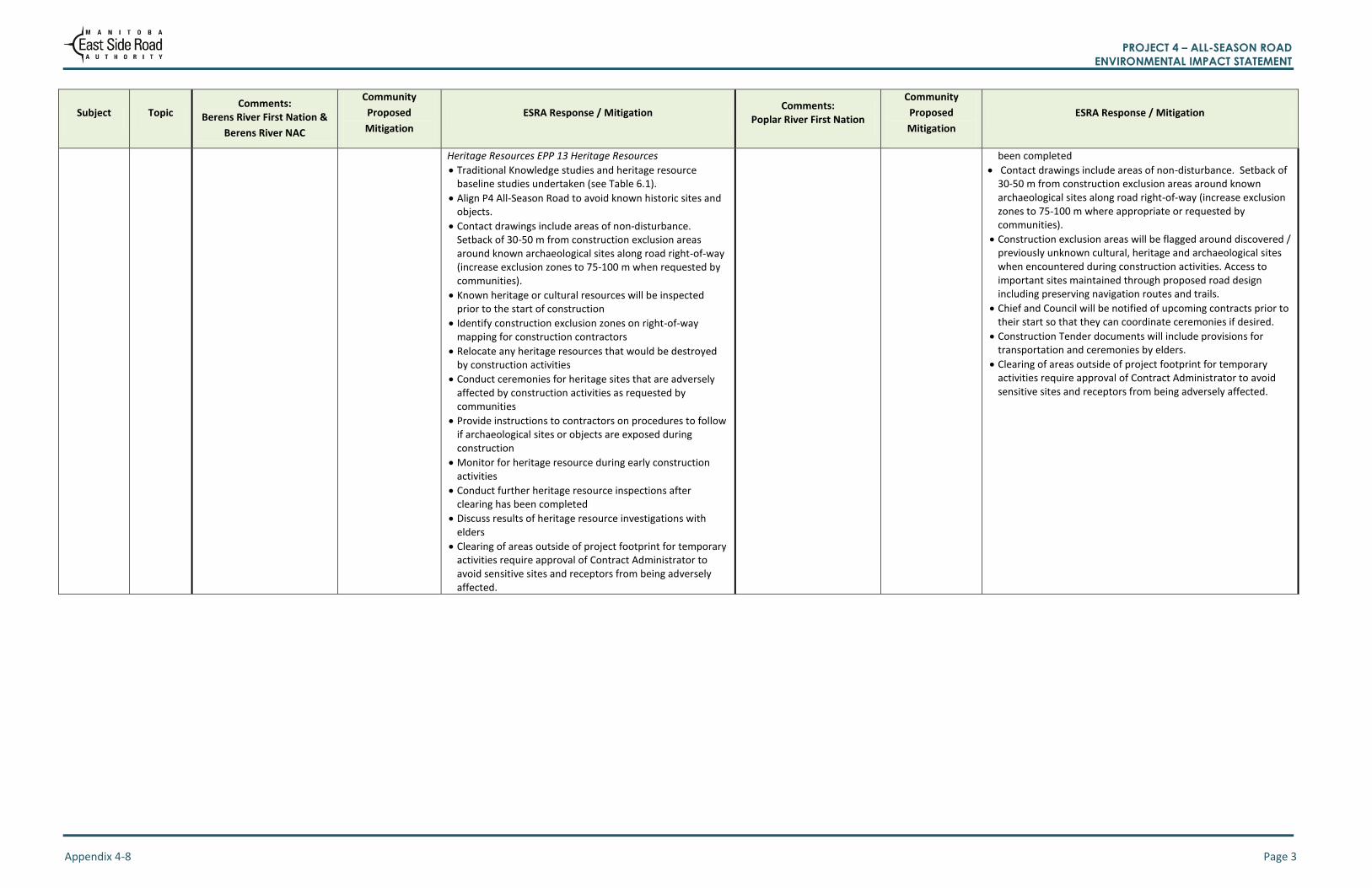
Traditional Knowledge studies and heritage resource baseline studies undertaken (see Table 6.1).
Align P4 All-Season Road to avoid known historic sites and objects.
Contact drawings include areas of non-disturbance. Setback of 30-50 m from construction exclusion areas around known archaeological sites along road right-of-way (increase exclusion zones to 75-100 m when requested by communities).
Known heritage or cultural resources will be inspected prior to the start of construction
Identify construction exclusion zones on right-of-way mapping for construction contractors
Relocate any heritage resources that would be destroyed by construction activities
Conduct ceremonies for heritage sites that are adversely affected by construction activities as requested by communities
Provide instructions to contractors on procedures to follow if archaeological sites or objects are exposed during construction
Monitor for heritage resource during early construction activities
Conduct further heritage resource inspections after clearing has been completed
Discuss results of heritage resource investigations with elders
Clearing of areas outside of project footprint for temporary activities require approval of Contract Administrator to avoid sensitive sites and receptors from being adversely affected.
been completed
Contact drawings include areas of non-disturbance. Setback of 30-50 m from construction exclusion areas around known archaeological sites along road right-of-way (increase exclusion zones to 75-100 m where appropriate or requested by communities).
Construction exclusion areas will be flagged around discovered / previously unknown cultural, heritage and archaeological sites when encountered during construction activities. Access to important sites maintained through proposed road design including preserving navigation routes and trails.
Chief and Council will be notified of upcoming contracts prior to their start so that they can coordinate ceremonies if desired.
Construction Tender documents will include provisions for transportation and ceremonies by elders.
Clearing of areas outside of project footprint for temporary activities require approval of Contract Administrator to avoid sensitive sites and receptors from being adversely affected.

PROJECT 4 – ALL-SEASON ROAD ENVIRONMENTAL IMPACT STATEMENT
Appendix 4-8 Page 4
Subject Topic Comments:
Berens River First Nation &
Berens River NAC
Community
Proposed
Mitigation
ESRA Response / Mitigation Comments:
Poplar River First Nation
Community
Proposed
Mitigation
ESRA Response / Mitigation
Biophysical Environment
Water
Quality
Potential effects of blasting residue on water. (Appendix 4-6; Table 4-6.1)
Request for community to have access to environmental monitoring reports for work around rivers.
Monitoring plans and summaries to be provided to communities.
Addressed in Construction Specifications and Environmental Protection Procedures (GR130’s. GR 140’s and EPPs ) i.e.) GR130.15 Working Within or Near Water EPP 6 Working Within or Near Fish Bearing Waters EPP 6 Working Within or Near Fish Bearing Waters EPP 12 Blasting Near A Watercourse,
While little blasting occurs near water except at crossings. DFO guidelines are followed. Blasting mitigation (e.g., charge size) will be implemented to minimize potential effects (Appendix 4-6, Table 4-6.1)
Quarry sites selection to avoid acid generating rock sources (Chapter 7, Section 7-23 and 7-24).
Undetonated explosive materials to be removed from blast rock prior to placement in or near watercourses
Ammonium nitrate-fuel oil mixtures are not to be used in or near watercourses
Avoid blasting in or on shorelines of watercourses
Explosive materials to be stored a minimum of 100 m from the high water mark
Potential effect of runoff from the road polluting the Poplar River (Poplar River Comments
from TK study Memo sent
August 2015)
Protect water quality through proper equipment maintenance and fuel storage; (Appendix 4-5, Table 4-5.2) Prohibit the use of
herbicides near
watercourses;
(Appendix 4-5,
Table 4-5.2)
See Table 7-8 (p.7-14) of the EIS document. Addressed in Construction Specifications and Environmental Protection Procedures (GR130’s and EPPs) i.e.) GR130.17 Clearing and Grubbing, EPP 1 Clearing and Grubbing, GR130.15 Working Within or Near Water EPP 6 Working Within or Near Fish Bearing Waters G 130.16 Erosion and Sediment Control
Construction activities will not occur within 100 m of a watercourse with the exception of construction of watercourse crossings.
Where a 100 m distance is not possible, a buffer zone of undisturbed vegetation between the construction activities and the watercourse will be established. The buffer zone width will be established according to the following formula: Width = 10 m + (1.5 X slope gradient) or 30 m whichever is greater.
Riparian vegetation clearing within the right-of-way will be limited to the removal of trees and tall shrubs (to maintain line of sight safety requirements) with no removal of low growing vegetation.
Clearing within 30 m of a watercourse will be completed by hand.
Clearing near watercourses will be temporarily suspended during very wet or muddy conditions.
Vegetation will be retained as long as possible to minimize the exposure time of disturbed/bare soils to potential erosion.
Clearing limits will be clearly marked prior to riparian vegetation removal to avoid unnecessary damage to or removal of vegetation.
Slash or debris piles will be stabilized and stored above the high water mark until disposal.
Overburden will be adequately stabilized and stored above the high water mark.
In-stream work will be conducted during winter months or low flow conditions and in isolation of flowing water (e.g., with the use of cofferdams, channel diversions, silt curtains) to mitigate downstream sediment transfer.
Silt curtains will be installed downstream of in-water work, if appropriate.
Appropriate erosion and sediment control (ESC) measures will be in place prior to the commencement of clearing and construction.
ESC measures will be regularly inspected and maintained to confirm effectiveness throughout construction.
Disturbed areas will be stabilized through revegetation with native plant species or other appropriate means (e.g., erosion control blankets) following completion of the works.
ESC measures will remain in place until disturbed areas are stabilized and revegetated.

PROJECT 4 – ALL-SEASON ROAD ENVIRONMENTAL IMPACT STATEMENT
Appendix 4-8 Page 5
Subject Topic Comments:
Berens River First Nation &
Berens River NAC
Community
Proposed
Mitigation
ESRA Response / Mitigation Comments:
Poplar River First Nation
Community
Proposed
Mitigation
ESRA Response / Mitigation
Water
Quality
Water plants may not return if water flows in creeks and muskeg areas are changed
Addressed in Construction Specifications and Environmental Protection Procedures (GR130’s and EPPs) i.e.) Working Within or Near Water EPP 6 Working Within or Near Fish Bearing Waters G 130.16 Erosion and Sediment Control, EPP 7 Stream Crossings EPP Culvert Maintenance and Replacement,
Appropriately designed watercourse crossing structures and appropriately designed, number and placement of equalization culverts will be installed to preserve existing surface water drainage patterns to the extent feasible (Project Description Chapter 3).
Maintaining existing water flow patterns, levels and wetland hydrologic regimes. Existing conditions maintained through road bed design that provides for water flow through road base and equalization culverts. (Project Description Chapter 3, Appendix 4-5, Table 4-5.1)
Potential for culvert blockage will be mitigated by installation of beaver cones and routine operations and maintenance activities of clearing vegetation, branches, mud, ice, snow, and other debris from culvert inlets to maintain hydraulic capacity.
Fish & Fish Habitat
Fish should still be able to travel upstream, and fish runs should not be restricted. (Appendix 4-4, Table 4-4.1) The protection of fish spawning areas is important. (Appendix 4-4, Table 4-4.1) Potential effects from increased harvest pressure and effects on fish populations; and (section 10.1.6.2 of EIS) Having design criteria for culverts at watercourse crossings is important; (Appendix 4-5, Table 4-5.1)
Suggest mitigation measures to address potential changes to habitat and disturbance from construction activities (Appendix 4-6, Table 4-6.1). For stream crossings, implementing erosion and sediment control measures at culverts were important and strongly supported (Appendix 4-6, Table 4-6.1)
See Tables 8.7 (p.8-32) and 8.8 (p.8-33) and section 8.2.4.1.1 of EIS
The amount of area to be permanently altered/destroyed has been minimized to the extent possible as part of the watercourse crossing designs.
Design culvert crossings to maintain existing flow regimes with no changes to flows or flow patterns.
Design culverts to meet fish passage criteria and requirements.
Potential for culvert blockage will be mitigated by routine operations and maintenance activities of clearing vegetation, branches, mud, ice, snow, and other debris from culvert inlets to maintain hydraulic capacity.
Install “beaver cones” or similar measures, where ongoing beaver activity occurs post-construction.
Crossing sites to avoid spawning areas
Addressed in Construction Specifications and Environmental
Protection Procedures (GR130’s and EPPs) i.e.) Working
Within or Near Water EPP 6 Working Within or Near Fish
Bearing Waters G 130.16 Erosion and Sediment Control, EPP 7
Stream Crossings GR 130.16 Erosion and Sediment Control GR
130.9 Material Handling, Storage and Disposal, GR 130.10
Spills and Remediation and Emergency Response GR130.17
Clearing and Grubbing EPP 7 Stream Crossings, EPP 9 Fish
Passage, EPP 10 Fish Salvage
Potential effects from culverts based on past experiences that fish may not spawn in waterways with culverts. (Poplar River Comments from TK study Memo sent August 2015) Recommended that small bridges be used at creek crossings, not culverts. Beavers will block culverts and cause flooding; high water in spring will flood over culverts. (Poplar River Comments from TK study Memo sent August 2015) Potential for pollution from the runoff from the road into Poplar River and the effect on fish populations (Poplar River Comments from TK study Memo sent August 2015) The rivers are taking longer to freeze than in the past (Appendix 4-4, Table 4-4.2)
Consider building more bridges rather than culverts; (Appendix 4-5, Table 4-5.2) Design culverts for passage and natural flow; (Appendix 4-5, Table 4-5.2; Appendix 4-6, Table 4-6.2)) Protect water quality through proper equipment maintenance and fuel storage; (Appendix 4-5, Table 4-5.2) Prohibit the use of
herbicides near
watercourses;
(Appendix 4-5,
Table 4-5.2)
See Tables 8.7 (p.8-32) and 8.8 (p.8-33) and section 8.2.4.1.1 of EIS
Culvert crossing designed for fish passage and 100 year flood events (Appendix 4-5, Table 4-5,4).
Design culvert crossings to maintain existing flow regimes (Appendix 4-6, Table 4-6.2)
Design culverts to meet fish passage criteria and requirements. (Appendix 4-6, Table 4-6.2)
Potential for culvert blockage will be mitigated by routine operations and maintenance activities of clearing vegetation, branches, mud, ice, snow, and other debris from culvert inlets to maintain hydraulic capacity.
Install “beaver cones” or similar measures, where ongoing beaver activity occurs post-construction.
Appropriately designed watercourse crossing structures and appropriately designed, number and placement of equalization culverts will be installed to preserve existing surface water drainage patterns to the extent feasible (Appendix 4-6, Table 4-6.2).
Where possible, roads will be located a minimum of 100 m from water bodies except when crossing a watercourse.
Addressed in Construction Specifications and Environmental Protection Procedures (GR130’s and EPPs) i.e.) Working Within or Near Water EPP 6 Working Within or Near Fish Bearing Waters G 130.16 Erosion and Sediment Control, EPP 7 Stream Crossings GR 130.16 Erosion and Sediment Control GR 130.9 Material Handling, Storage and Disposal, GR 130.10 Spills and Remediation and Emergency Response EPP 6 Working Within or Near Fish Bearing
PROJECT 4 – ALL-SEASON ROAD ENVIRONMENTAL IMPACT STATEMENT
Appendix 4-8 Page 6
Subject Topic Comments:
Berens River First Nation &
Berens River NAC
Community
Proposed
Mitigation
ESRA Response / Mitigation Comments:
Poplar River First Nation
Community
Proposed
Mitigation
ESRA Response / Mitigation
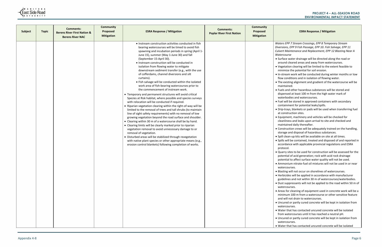
Instream construction activities conducted in fish bearing watercourses will be timed to avoid fish spawning and incubation periods in spring (April 1-June 15), summer (May 1-June 30) and fall (September 15-April 30).
Instream construction will be conducted in isolation from flowing water to mitigate downstream sediment transfer (e.g., with the use of cofferdams, channel diversions and silt curtains).
Fish salvage will be conducted within the isolated work area of fish-bearing watercourses prior to the commencement of instream work.
Temporary and permanent structures will avoid critical Species at Risk habitat, where possible and species surveys with relocation will be conducted if required.
Riparian vegetation clearing within the right-of-way will be limited to the removal of trees and tall shrubs (to maintain line of sight safety requirements) with no removal of low growing vegetation beyond the road surface and shoulder.
Clearing within 30 m of a watercourse shall be by hand.
Clearing limits will be clearly marked prior to riparian vegetation removal to avoid unnecessary damage to or removal of vegetation.
Disturbed areas will be stabilized through revegetation with native plant species or other appropriate means (e.g., erosion control blankets) following completion of works.
Waters EPP 7 Stream Crossings, EPP 8 Temporary Stream Diversions, EPP 9 Fish Passage, EPP 10. Fish Salvage, EPP 11 Culvert Maintenance and Replacement, EPP 12 Blasting Near A Watercourse
Surface water drainage will be directed along the road or around cleared areas and away from watercourses.
Vegetation clearing will be limited to the extent feasible to minimize the potential for soil erosion.
In-stream work will be conducted during winter months or low flow conditions and in isolation of flowing water.
The existing alignment and gradient of the watercourse will be maintained.
Fuels and other hazardous substances will be stored and dispensed at least 100 m from the high water mark of waterbodies and watercourses.
Fuel will be stored in approved containers with secondary containment for potential leaks/spills.
Drip-trays, blankets or pads will be used when transferring fuel at construction sites.
Equipment, machinery and vehicles will be checked for cleanliness and leaks upon arrival to site and checked and maintained daily thereafter.
Construction crews will be adequately trained on the handling, storage and disposal of hazardous substances.
Spill clean-up kits will be available on site at all times.
Spills will be contained, treated and disposed of and reported in accordance with applicable provincial regulations and ESRA protocol.
Quarry sites to be used for construction will be assessed for the potential of acid generation; rock with acid rock drainage potential to affect surface water quality will not be used.
Ammonium nitrate-fuel oil mixtures will not be used in or near watercourses.
Blasting will not occur on shorelines of watercourses.
Herbicides will be applied in accordance with manufacturer guidelines and not within 30 m of watercourses/waterbodies.
Dust suppressants will not be applied to the road within 50 m of watercourses.
Areas for cleaning of equipment used in concrete work will be a minimum 100 m from a watercourse or other sensitive feature and will not drain to watercourses.
Uncured or partly cured concrete will be kept in isolation from watercourses.
Water that has contacted uncured concrete will be isolated from watercourses until it has reached a neutral pH.
Uncured or partly cured concrete will be kept in isolation from watercourses.
Water that has contacted uncured concrete will be isolated
PROJECT 4 – ALL-SEASON ROAD ENVIRONMENTAL IMPACT STATEMENT
Appendix 4-8 Page 7
Subject Topic Comments:
Berens River First Nation &
Berens River NAC
Community
Proposed
Mitigation
ESRA Response / Mitigation Comments:
Poplar River First Nation
Community
Proposed
Mitigation
ESRA Response / Mitigation
from watercourses until it has reached a neutral pH.
Equipment used in concrete work will be cleaned away from watercourses to prevent wash water from entering waterways. GR130.15.2 Timing of Work
Water quality monitoring for in water works
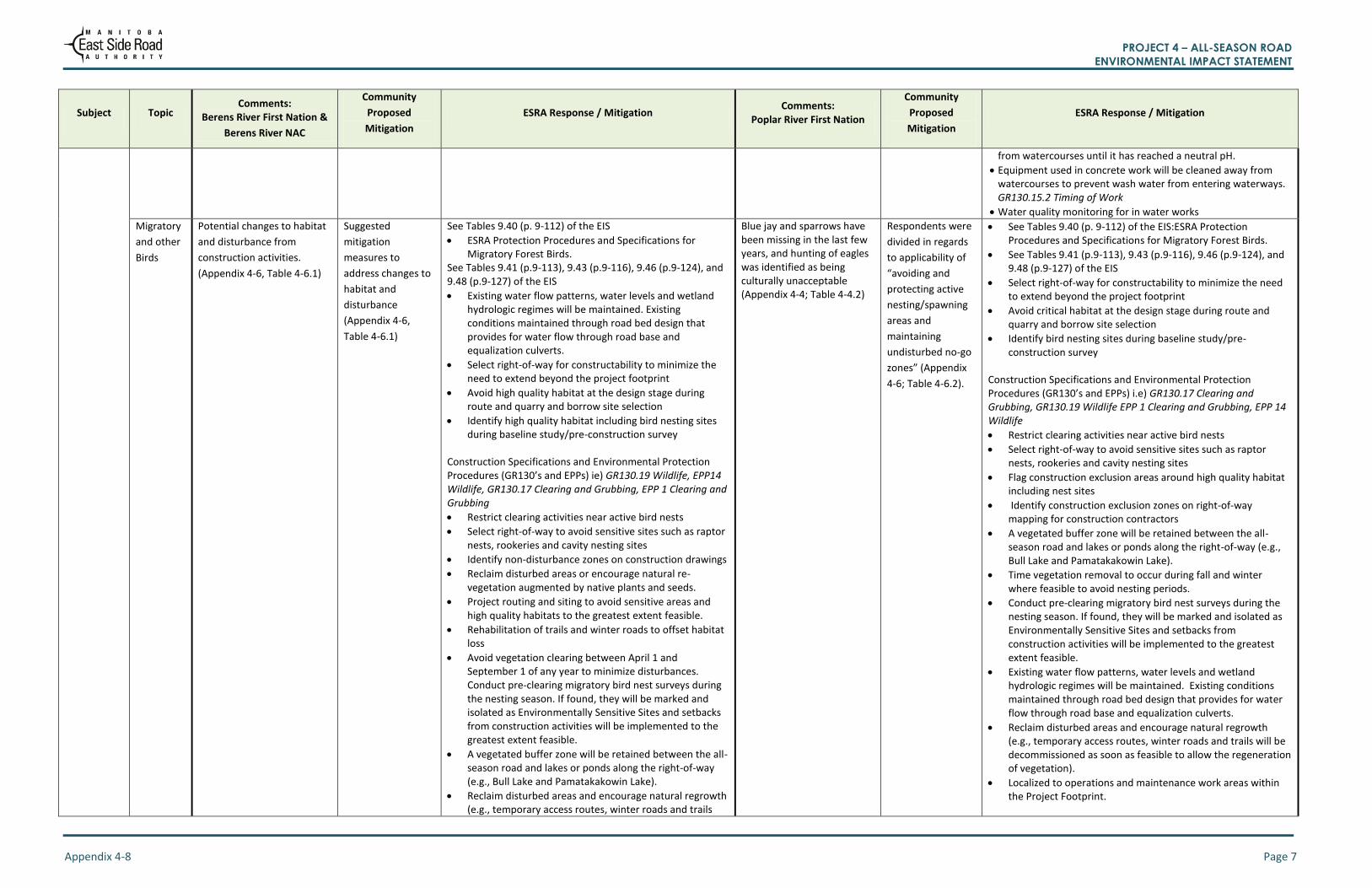
Migratory
and other
Birds
Potential changes to habitat
and disturbance from
construction activities.
(Appendix 4-6, Table 4-6.1)
Suggested
mitigation
measures to
address changes to
habitat and
disturbance
(Appendix 4-6,
Table 4-6.1)
See Tables 9.40 (p. 9-112) of the EIS
ESRA Protection Procedures and Specifications for Migratory Forest Birds.
See Tables 9.41 (p.9-113), 9.43 (p.9-116), 9.46 (p.9-124), and 9.48 (p.9-127) of the EIS
Existing water flow patterns, water levels and wetland hydrologic regimes will be maintained. Existing conditions maintained through road bed design that provides for water flow through road base and equalization culverts.
Select right-of-way for constructability to minimize the need to extend beyond the project footprint
Avoid high quality habitat at the design stage during route and quarry and borrow site selection
Identify high quality habitat including bird nesting sites during baseline study/pre-construction survey
Construction Specifications and Environmental Protection Procedures (GR130’s and EPPs) ie) GR130.19 Wildlife, EPP14 Wildlife, GR130.17 Clearing and Grubbing, EPP 1 Clearing and Grubbing
Restrict clearing activities near active bird nests
Select right-of-way to avoid sensitive sites such as raptor nests, rookeries and cavity nesting sites
Identify non-disturbance zones on construction drawings
Reclaim disturbed areas or encourage natural re-vegetation augmented by native plants and seeds.
Project routing and siting to avoid sensitive areas and high quality habitats to the greatest extent feasible.
Rehabilitation of trails and winter roads to offset habitat loss
Avoid vegetation clearing between April 1 and September 1 of any year to minimize disturbances. Conduct pre-clearing migratory bird nest surveys during the nesting season. If found, they will be marked and isolated as Environmentally Sensitive Sites and setbacks from construction activities will be implemented to the greatest extent feasible.
A vegetated buffer zone will be retained between the all-season road and lakes or ponds along the right-of-way (e.g., Bull Lake and Pamatakakowin Lake).
Reclaim disturbed areas and encourage natural regrowth (e.g., temporary access routes, winter roads and trails
Blue jay and sparrows have been missing in the last few years, and hunting of eagles was identified as being culturally unacceptable (Appendix 4-4; Table 4-4.2)
Respondents were
divided in regards
to applicability of
“avoiding and
protecting active
nesting/spawning
areas and
maintaining
undisturbed no-go
zones” (Appendix
4-6; Table 4-6.2).
See Tables 9.40 (p. 9-112) of the EIS:ESRA Protection Procedures and Specifications for Migratory Forest Birds.
See Tables 9.41 (p.9-113), 9.43 (p.9-116), 9.46 (p.9-124), and 9.48 (p.9-127) of the EIS
Select right-of-way for constructability to minimize the need to extend beyond the project footprint
Avoid critical habitat at the design stage during route and quarry and borrow site selection
Identify bird nesting sites during baseline study/pre-construction survey
Construction Specifications and Environmental Protection Procedures (GR130’s and EPPs) i.e) GR130.17 Clearing and Grubbing, GR130.19 Wildlife EPP 1 Clearing and Grubbing, EPP 14 Wildlife
Restrict clearing activities near active bird nests
Select right-of-way to avoid sensitive sites such as raptor nests, rookeries and cavity nesting sites
Flag construction exclusion areas around high quality habitat including nest sites
Identify construction exclusion zones on right-of-way mapping for construction contractors
A vegetated buffer zone will be retained between the all-season road and lakes or ponds along the right-of-way (e.g., Bull Lake and Pamatakakowin Lake).
Time vegetation removal to occur during fall and winter where feasible to avoid nesting periods.
Conduct pre-clearing migratory bird nest surveys during the nesting season. If found, they will be marked and isolated as Environmentally Sensitive Sites and setbacks from construction activities will be implemented to the greatest extent feasible.
Existing water flow patterns, water levels and wetland hydrologic regimes will be maintained. Existing conditions maintained through road bed design that provides for water flow through road base and equalization culverts.
Reclaim disturbed areas and encourage natural regrowth (e.g., temporary access routes, winter roads and trails will be decommissioned as soon as feasible to allow the regeneration of vegetation).
Localized to operations and maintenance work areas within the Project Footprint.

PROJECT 4 – ALL-SEASON ROAD ENVIRONMENTAL IMPACT STATEMENT
Appendix 4-8 Page 8
Subject Topic Comments:
Berens River First Nation &
Berens River NAC
Community
Proposed
Mitigation
ESRA Response / Mitigation Comments:
Poplar River First Nation
Community
Proposed
Mitigation
ESRA Response / Mitigation
will be decommissioned as soon as feasible to allow the regeneration of vegetation).
Moose
Suggested mitigation to address potential changes to habitat for VCs such as moose were identified as being very important (Appendix 4-6; Table 4-6.1). Suggested mitigation measures for accidental collisions between wildlife and vehicles were supported (Appendix 4-6; Table 4-6.1). Moose are not scared of blasting or drilling. (Appendix 4-5; Table 4-5.1) Moose are hunted in identified areas (Appendix 4-4; Table 4-4.2; Appendix 4-5, Table 4-5.3). Moose are very important to the community, and should be a VC (Appendix 4-4, Table 4-4.1)
Need for mitigation measures that address disturbance from construction activities (Appendix 4-6, Table 4-6.1)
The area along the North Etomami River just north of the Berens River junction is a community sensitive habitat area, and should be avoided. Happy to see the P4-ASR has been moved away from this area based on community feedback (Appendix 4-4; Table 4-4.1, Chapter 5, Table 5.1). Discussions related to restricting hunting along the road involved mention of discussions with MCWS regarding the extension of a wildlife refuge along the road alignment (Appendix 4-5, Table 4-5.4; Appendix 4-6; Table 4-6.1).
See Table 9.20 (p. 9-61) of the EIS: ESRA’s protection procedures and specifications for ungulates.
See Table 9-21 (p.9-61) and Section 9.2.5.1.1 of EIS
See Table 7-11 (p.7-37) of EIS
Apply design mitigation measures (Section 9.2).
ESRA has relocated the P4 alignment in light of environmental and land use commentary from Berens River First Nation (section 2.2.2 of the EIS). These changes include a realignment of the route out from Berens River First Nation to avoid important habitat, but in doing so adds a significant water crossing (Chapter 5, Table 5.1).
Maintaining existing water flow patterns, levels and wetland hydrologic regimes. Existing conditions maintained through road bed design that provides for water flow through road base and equalization culverts.
Rock selected for use as a quarry is tested and has not been found to be acid bearing (Appendix 4-6; Table 4-6.4)
Routing all-season road to avoid sensitive habitat where feasible.
Addressed in Construction Specifications and Environmental Protection Procedures (GR130’s and EPPs) GR130.17 Clearing and Grubbing, GR130.19 Wildlife EPP 1 Clearing and Grubbing, EPP 14 Wildlife
Limiting riparian vegetation clearing within the project footprint (to maintain line of sight safety requirements) to the greatest extent possible.
Timing road clearing to occur during fall and winter to the extent feasible to avoid parturition times for moose.
Using existing access routes, trails, or cut lines to the extent feasible and access routes and trails will be kept as short and narrow as feasible.
Decommissioning the existing winter road to allow the regeneration of vegetation.
Decommissioning temporary access routes and trails as soon as feasible to allow the regeneration of vegetation.
Decommissioning winter roads, temporary access routes and trails to block off/limit human access.
Identifying mineral licks and including them in Environmental Protection Procedures as Environmentally Sensitive Sites.
Potential effects on moose behaviour due to blasting (Appendix 4-4; Table 4-4.3); Moose are hunted in identified areas (Appendix 4-4, Table 4-4.1)
Blasting should not take place between August to November to prevent disturbance during rutting season and the community moose hunt in the fall; and (Poplar River Comments from TK study Memo sent August 2015) A wildlife refuge is a good mitigation measure. (Appendix 4-4, Table 4-4.2; Appendix 4-5, Table 4-5.4; Appendix 4-6, Table 4-6.1) ESRA should
continue to carry
out its moose
monitoring
program several
years after
construction
(Appendix 4-5,
Table 4-5.4)
Applying design mitigation measures (Section 9.2).
See Table 9.20 (p. 9-61) of the EIS: ESRA’s protection procedures and specifications for ungulates.
See Table 7-11 (p.7-37) of EIS
Scheduling of blasting will occur when in the vicinity of sensitive sites.
See Table 9-21 (p.9-62), Table 9.22 (p. 9-67) and Section 9.2.5.1.1
Select right-of-way for constructability to minimize the need to extend beyond the project footprint
Where possible, avoid sensitive habitat at the design stage during route and quarry and borrow site selection
Addressed in Construction Specifications and Environmental Protection Procedures (GR130’s and EPPs) i.e) GR130.17 Clearing and Grubbing, GR130.19 Wildlife EPP 1 Clearing and Grubbing, EPP 14 Wildlife
Identify construction non-disturbance zones on construction drawings
Routing all-season road to avoid areas of high quality habitat where feasible.
Limiting riparian vegetation clearing within the right-of-way to the removal of trees and tall shrubs (to maintain line of sight safety requirements).
Timing road clearing to occur during fall and winter to the extent feasible to avoid parturition times for moose.
Maintaining existing water flow patterns, levels and wetland hydrologic regimes. Existing conditions maintained through road bed design that provides for water flow through road base and equalization culverts.
Staging construction as required (i.e., stop and delay construction activities in sensitive areas until animal use of the area and/or sensitive time period has passed).
Using existing access routes, trails, or cut lines to the extent feasible and access routes and trails will be kept as short and narrow as feasible.
Decommissioning the existing winter road to allow the regeneration of vegetation.
Decommissioning temporary access routes and trails as soon as feasible to allow the regeneration of vegetation.
Decommissioning winter roads, temporary access routes and trails to block off/limit human access.
Identifying mineral licks and including them in Environmental Protection Procedures as Environmentally Sensitive Sites.
Routing all-season road to avoid areas of high quality habitat

PROJECT 4 – ALL-SEASON ROAD ENVIRONMENTAL IMPACT STATEMENT
Appendix 4-8 Page 9
Subject Topic Comments:
Berens River First Nation &
Berens River NAC
Community
Proposed
Mitigation
ESRA Response / Mitigation Comments:
Poplar River First Nation
Community
Proposed
Mitigation
ESRA Response / Mitigation
where feasible.
Limiting construction to work areas within the Project Footprint and Local Assessment Area (quarries)
Clearing during fall and winter to the extent feasible to avoid parturition times for moose.
Applying dust suppression techniques as per ESRA’s GR130s and Environmental Protection Procedures
Staging construction in sensitive areas until animal use of the area and/or sensitive time period has passed.
Using existing access routes, trails, or cut lines to the extent feasible and access routes and trails will be kept as short and narrow as feasible.
Caribou
Caribou calving occurs on the west side of the alignment and they migrate to areas east of the alignment (Appendix 4-6; Table 4-6.1) Caribou run north and south
far to the east of the road
alignment after freeze up in
the fall and spring.
(Appendix 4-4, Table 4-4.1)
Strong support for mitigation measures that address disturbance from construction activities (Appendix 4-6, Table 4-6.1)
See Table 9.20 (p. 9-61) of the EIS: ESRA’s protection procedures and specifications for ungulates.
See Tables 9.25 (9-78) and 9.26 (9-84) of the EIS.
Applying design mitigation measures (Section 9.2).
Routing all-season road to avoid areas of critical habitat where feasible.
Addressed in Construction Specifications and Environmental Protection Procedures (GR130’s and EPPs) i.e) GR130.17 Clearing and Grubbing, GR130.19 Wildlife EPP 1 Clearing and Grubbing, EPP 14 Wildlife
Limiting riparian vegetation clearing within the right-of-way to the removal of trees and tall shrubs (to maintain line of sight safety requirements).
Timing road clearing to occur during fall and winter to the extent feasible to avoid parturition times for boreal woodland caribou.
Maintaining existing water flow patterns, levels and wetland hydrologic regimes. Existing conditions maintained through road bed design that provides for water flow through road base and equalization culverts.
Staging construction as required, i.e., stop and delay construction activities in sensitive areas until animal use of the area and/or sensitive time period has passed.
Using existing access routes, trails, or cut lines to the extent feasible and access routes and trails will be kept as short and narrow as feasible.
Decommissioning the existing winter road to allow the regeneration of vegetation.
Decommissioning temporary access routes and trails as soon as feasible to allow the regeneration of vegetation.
Decommissioning winter roads, temporary access routes and trails to block off/limit human access.
Identifying mineral licks and including them in EPPs as Environmentally Sensitive Sites.
Routing all-season road to avoid areas of high quality
Safety of construction workers during hunting season ; (Poplar River Comments from TK study Memo sent August 2015)
ESRA communication program advertises location of construction activities in community. Addressed in Construction Specifications and Environmental Protection Procedures (GR130’s, GR 140’s and EPPs) i.e) GR130.8 Designated Areas and Access, GR130.19 Wildlife EPP 14 Wildlife GR140.5 Safe Work Plan,
Safe work plans required for all construction activities. Contactors employ signs, access controls etc to ensure safety
Public prohibited from accessing construction sites for safety purposes
The contractor is prohibited from hunting and carrying fire arms

PROJECT 4 – ALL-SEASON ROAD ENVIRONMENTAL IMPACT STATEMENT
Appendix 4-8 Page 10
Subject Topic Comments:
Berens River First Nation &
Berens River NAC
Community
Proposed
Mitigation
ESRA Response / Mitigation Comments:
Poplar River First Nation
Community
Proposed
Mitigation
ESRA Response / Mitigation
habitat where feasible.
Limiting construction to work areas within the Project Footprint and Local Assessment Area (quarries).
Clearing during fall and winter to the extent feasible to avoid parturition times for boreal woodland caribou.
Suspending quarry blasting and other construction activities near sensitive sites during spring months to avoid parturition times for boreal woodland caribou.
Applying dust suppression techniques.
Staging construction, i.e., to avoid sensitive timeframes as appropriate.
Using existing access routes, trails, or cut lines to the extent feasible and access routes and trails will be kept as short and narrow as feasible.
Localized operations and maintenance work areas within the Project Footprint
Road, bridge and culvert maintenance activities will be timed to occur during fall and winter to the extent feasible to avoid parturition times for caribou.
The all-season road will be a two-lane gravel road low traffic volumes
Road designed to optimize line of sight to minimize risk of traffic collision.
Road designed with no pull outs or parking areas to limit hunting opportunities from road.
Vegetation Potential for increased access to harvest areas for plants, berries, and medicines (Appendix 4-5, Table 4-5.1)
Could be a benefit to the community (Appendix 4-5, Table 4-5.1) Revegetation along the alignment and borrow locations from construction were identified as important to community members and strongly suggested (Appendix 4-6, 4-6.1) Boat and
snowmobile launch
points should not
be provided at
river and stream
crossings
(Appendix 4-4,
Boat and snowmobile launch points are not planned at river and stream crossings Addressed in Construction Specifications and Environmental Protection Procedures (GR130’s) i.e) Special Provision 19 Re-vegetation
Disturbed areas will be allowed to reestablish or stabilized through revegetation with native plant species or other appropriate means (e.g., erosion control blankets) following completion of the works.

PROJECT 4 – ALL-SEASON ROAD ENVIRONMENTAL IMPACT STATEMENT
Appendix 4-8 Page 11
Subject Topic Comments:
Berens River First Nation &
Berens River NAC
Community
Proposed
Mitigation
ESRA Response / Mitigation Comments:
Poplar River First Nation
Community
Proposed
Mitigation
ESRA Response / Mitigation
Table 4-4.1)
Furbearers There is important habitat in bogs for species such as muskrat (Appendix 4-5, Table 4-5.1) Wetlands and other feeding areas are where furbearers are seen and trapped in winter. (Appendix 4-5, Table 4-5.1) Wildlife movements: starting
to see more wolverines
coming into the community
(Appendix 4-4, Table 4-4.1)
Suggest that ESRA consider using signage for trapline boundaries (Appendix 4-6, Table 4-6.1) Strong support for
mitigation
measures that
address
disturbance from
construction
activities (Appendix
4-6, Table 4-6.1)
Addressed in Construction Specifications and Environmental Protection Procedures (GR130’s and EPPs) i.e.) GR130.17 Clearing and Grubbing, GR130.19 Wildlife, EPP 1 Clearing and Grubbing, EPP 14 Wildlife
Select right-of-way for constructability to minimize the need to extend beyond the project footprint. Avoid bogs and fens where possible
Dens identified during surveys and baseline studies to be addressed in construction planning (phasing)
Where dens are encountered during work, adaptive measures will be taken as required.
Avoid vegetation clearing between April 1 and September 1 of any year to minimize disturbances
Block access to temporary activity and access trails upon decommissioning and reclaim disturbed areas and encourage natural re-vegetation augmented by native plants and seeds
Use of Lands / Traditional
Resources
The need to preserve the
land and ecology from
further resource
development.
Increased access
will require
increased
enforcements as
well as possible
regulation changes
to allow for the
continued viability
and livelihood of
local residents
(Appendix 4-5,
Table 4-5.1)
New developments will require separate approvals and licensing.
Berens River has the option of registering a traditional zoning plan identifying acceptable land uses in their traditional territory under The East Side Traditional Lands Planning and Special Protected Areas Act
Potential Project effects of noise on hunting; (Poplar River Comments from TK study Memo sent August 2015) Increase in unwanted access to the Poplar River (Poplar River Comments
from TK study Memo sent
August 2015)
Consider quads/ATVs river crossings for use solely by community members not outsiders; and (Appendix 4-5, Table 4-5.2) Consider
constructing boat
launches for use
solely by
community
members not
outsiders.
(Appendix 4-5,
Table 4-5.2)
See Tables 7-11 (p.7-37) and 10-10 of EIS
Avoid construction of boat launches and decommissioning temporary access routes required for construction.
Design road with no pull-off areas Addressed in Construction Specifications and Environmental Protection Procedures (GR130’s and EPPs) i.e.) GR130.12 Noise and Noise Limitations, GR 130.19 Wildlife EPP 4 Noise Control EPP 14 Wildlife
Seasonally restrict disruptive maintenance activities adjacent to known sensitive sites
Restrict public access to construction sites
Prohibit firearms from being carried by construction workers while on the job site or in construction areas
Block abandoned access roads and encourage natural re-vegetation segmented by native plants and seeds
Contractors, employees and agents shall not hunt, trap or harass wildlife
Potential for displacement of community members’ traditional trap lines within the proposed road alignment. (Appendix 4-4, Table 4-4.3)
Trappers to be notified when and where construction will occur so that traps in the area can be relocated; (Appendix 4-4, Table 4-4.1)
Provide information about the proposed project to trappers
Provide community updates regarding location and timing of construction activities that could result in limited access so that alternative routes can be planned.
Addressed in Construction Specifications and Environmental Protection Procedures (GR130’s, and EPPs) i.e) GR130.8 Designated Areas and Access, GR130.17.3 Grubbing, Special
Berries and medicinal plants may be temporarily disturbed during construction, but will grow back;
Water plants may not return if water flows in creeks and muskeg areas are changed; and
Block abandoned
access roads
See Table 10-10 and 10-11 (p.10-52; p. 10-53) in EIS
Maintaining existing water flow patterns, levels and wetland hydrologic regimes. Existing conditions maintained through road bed design that provides for water flow through road base and equalization culverts.
Identified plant gathering areas during traditional knowledge studies. Harvest areas avoided with road alignment selection.
Addressed in Construction Specifications and Environmental
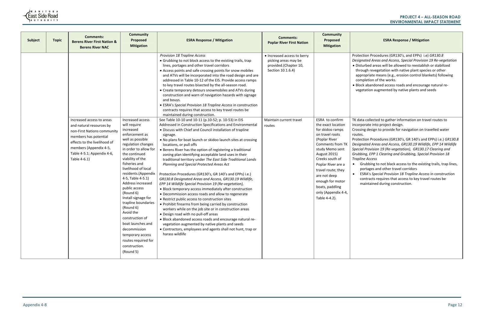
PROJECT 4 – ALL-SEASON ROAD ENVIRONMENTAL IMPACT STATEMENT
Appendix 4-8 Page 12
Subject Topic Comments:
Berens River First Nation &
Berens River NAC
Community
Proposed
Mitigation
ESRA Response / Mitigation Comments:
Poplar River First Nation
Community
Proposed
Mitigation
ESRA Response / Mitigation
Provision 18 Trapline Access
Grubbing to not block access to the existing trails, trap lines, portages and other travel corridors
Access points and safe crossing points for snow mobiles and ATVs will be incorporated into the road design and are addressed in Table 10-12 of the EIS. Provide access ramps to key travel routes bisected by the all-season road.
Create temporary detours snowmobiles and ATVs during construction and warn of navigation hazards with signage and bouys.
ESRA’s Special Provision 18 Trapline Access in construction contracts requires that access to key travel routes be maintained during construction.
Increased access to berry picking areas may be provided.(Chapter 10, Section 10.1.6.4)
Protection Procedures (GR130’s, and EPPs) i.e) GR130.8 Designated Areas and Access, Special Provision 19 Re-vegetation
Disturbed areas will be allowed to reestablish or stabilized through revegetation with native plant species or other appropriate means (e.g., erosion control blankets) following completion of the works.
Block abandoned access roads and encourage natural re-vegetation augmented by native plants and seeds
Increased access to areas
and natural resources by
non-First Nations community
members has potential
effects to the livelihood of
members (Appendix 4-5,
Table 4-5.1; Appendix 4-6,
Table 4-6.1)
Increased access will require increased enforcement as well as possible regulation changes in order to allow for the continued viability of the fisheries and livelihood of local residents.(Appendix 4-5, Table 4-5.1) Address increased public access (Round 6) Install signage for trapline boundaries (Round 6) Avoid the
construction of
boat launches and
decommission
temporary access
routes required for
construction.
(Round 5)
See Table 10-10 and 10-11 (p.10-52; p. 10-53) in EIS Addressed in Construction Specifications and Environmental
Discuss with Chief and Council installation of trapline signage.
No plans for boat launch or skidoo launch sites at crossing locations, or pull offs
Berens River has the option of registering a traditional zoning plan identifying acceptable land uses in their traditional territory under The East Side Traditional Lands Planning and Special Protected Areas Act
Protection Procedures (GR130’s, GR 140’s and EPPs) i.e.) GR130.8 Designated Areas and Access, GR130.19 Wildlife, EPP 14 Wildlife Special Provision 19 (Re-vegetation),
Block temporary access immediately after construction
Decommission access roads and allow to regenerate
Restrict public access to construction sites
Prohibit firearms from being carried by construction workers while on the job site or in construction areas
Design road with no pull-off areas
Block abandoned access roads and encourage natural re-vegetation augmented by native plants and seeds
Contractors, employees and agents shall not hunt, trap or harass wildlife
Maintain current travel
routes
ESRA to confirm the exact location for skidoo ramps on travel roots (Poplar River Comments from TK study Memo sent August 2015) Creeks south of
Poplar River are a
travel route; they
are not deep
enough for motor
boats, paddling
only (Appendix 4-4,
Table 4-4.2).
TK data collected to gather information on travel routes to incorporate into project design. Crossing design to provide for navigation on travelled water routes. Protection Procedures (GR130’s, GR 140’s and EPPs) i.e.) GR130.8 Designated Areas and Access, GR130.19 Wildlife, EPP 14 Wildlife Special Provision 19 (Re-vegetation), GR130.17 Clearing and Grubbing, EPP 1 Clearing and Grubbing, Special Provision 18 Trapline Access
Grubbing to not black access to the existing trails, trap lines, portages and other travel corridors
ESRA’s Special Provision 18 Trapline Access in construction contracts requires that access to key travel routes be maintained during construction.
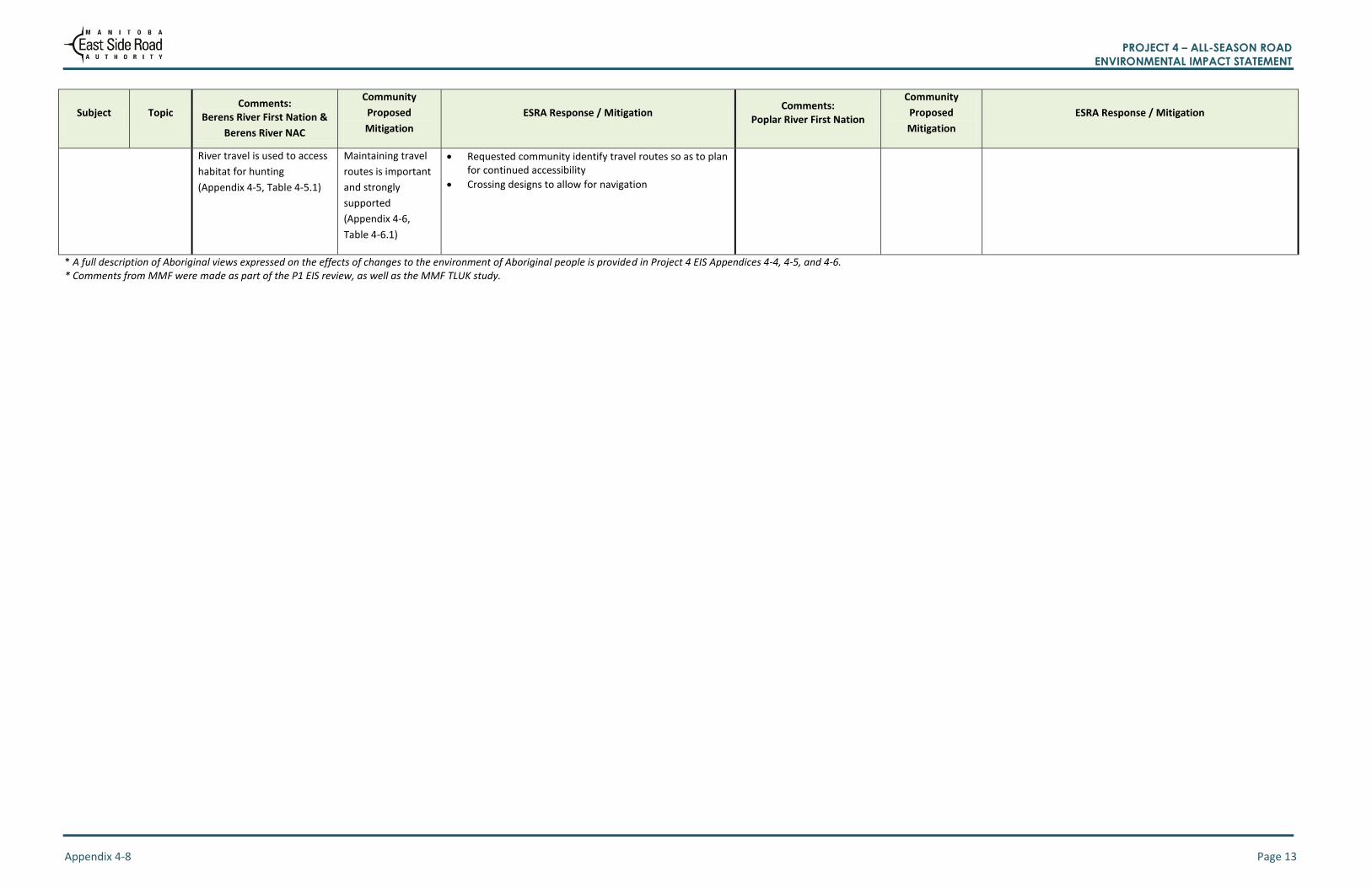
PROJECT 4 – ALL-SEASON ROAD ENVIRONMENTAL IMPACT STATEMENT
Appendix 4-8 Page 13
Subject Topic Comments:
Berens River First Nation &
Berens River NAC
Community
Proposed
Mitigation
ESRA Response / Mitigation Comments:
Poplar River First Nation
Community
Proposed
Mitigation
ESRA Response / Mitigation
River travel is used to access
habitat for hunting
(Appendix 4-5, Table 4-5.1)
Maintaining travel
routes is important
and strongly
supported
(Appendix 4-6,
Table 4-6.1)
Requested community identify travel routes so as to plan for continued accessibility
Crossing designs to allow for navigation
* A full description of Aboriginal views expressed on the effects of changes to the environment of Aboriginal people is provided in Project 4 EIS Appendices 4-4, 4-5, and 4-6. * Comments from MMF were made as part of the P1 EIS review, as well as the MMF TLUK study.
PROJECT 4 – ALL-SEASON ROAD ENVIRONMENTAL IMPACT STATEMENT
Appendix 4-9 Page 1
Appendix 4-9
Project Comments from Manitoba Metis
Federation and ESRA Responses

PROJECT 4 – ALL-SEASON ROAD ENVIRONMENTAL IMPACT STATEMENT
Appendix 4-9 Page 1
Table 4-9.1: Project Comments from Manitoba Metis Federation and ESRA Responses
Effects of
Changes to the
Environment
Topic Comments: Manitoba Metis Federation
Community Proposed
Mitigation
ESRA Response / Mitigation
Physical &
Cultural
Heritage
Cultural /
Important Sites
Potential for post-contact heritage
sites to be encountered during the
pre-construction or construction
phases of the all-season road
project (ESRA/MMF meeting,
Oct.28, 2016)
N/A ESRA has undertaken extensive archeological studies supported by traditional knowledge information of the project area. No post –contact sites were identified. ESRA has protocols outlined in the Environmental Protection Plan #13 and the GR130s (Chapter 5) in the event that heritage resources are identified during construction. ESRA will advise MMF of any post-contact heritage sites that are found, prior to any decisions on how to address such resources. (ESRA/MMF meeting, Oct.28,2016, Letter from ESRA to MMF December 21, 2016) Commitment to engage with the MMF in the future if items
identified during project execution (ESRA letter, Dec. 21, 2015)
Biophysical
Environment
Fish / Migratory
Birds / Moose
Decrease in animals and fish
populations resulting from
increased harvest pressure, traffic-
related animal mortality, and/or
habitat loss, alteration,
fragmentation, and/or decreased
access to animal and fish
populations due to species
avoidance of harvesting areas
associated with road construction
and operation. (MMF TLUK study,
2011)
MMF has interest in project monitoring plans. (MMF TLUK study, 2011)
ESRA has provided project information to the MMF (Project Description, Scoping Documents and EIS) attended meetings ( June 5, 105, October 28, 2015) and extended the contract to complete traditional knowledge and land use study (December 31
st 2015,
extended to March 31, 2016 and then extended to May 31, 2016) to facilitate understanding of possible effects. Design mitigation measures include selecting alignments with consideration of harvest areas and sensitive wildlife habitat, road geometry to provide clear lines of sight to prevent traffic related mortalities, stream and river crossings structures provide for fish passage, etc. Construction and operational (maintenance) phase protection measures documented in the GR130s and the EPPs to avoid or minimize effects to habitat, wildlife and fish and their habitat (i.e. erosion control, limiting footprint of the project, wildlife non-disturbance requirements, construction timing to avoid sensitive life stages) (see Chapters 5, 8, 9).
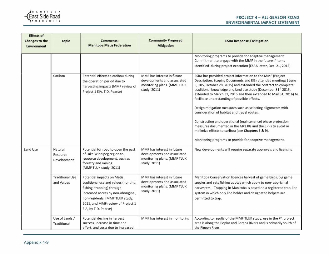
PROJECT 4 – ALL-SEASON ROAD ENVIRONMENTAL IMPACT STATEMENT
Appendix 4-9 Page 2
Effects of
Changes to the
Environment
Topic Comments: Manitoba Metis Federation
Community Proposed
Mitigation
ESRA Response / Mitigation
Monitoring programs to provide for adaptive management Commitment to engage with the MMF in the future if items
identified during project execution (ESRA letter, Dec. 21, 2015)
Caribou Potential effects to caribou during
the operation period due to
harvesting impacts (MMF review of
Project 1 EIA, T.D. Pearse)
MMF has interest in future developments and associated monitoring plans. (MMF TLUK study, 2011)
ESRA has provided project information to the MMF (Project Description, Scoping Documents and EIS) attended meetings ( June 5, 105, October 28, 2015) and extended the contract to complete traditional knowledge and land use study (December 31
st 2015,
extended to March 31, 2016 and then extended to May 31, 2016) to facilitate understanding of possible effects. Design mitigation measures such as selecting alignments with consideration of habitat and travel routes. Construction and operational (maintenance) phase protection measures documented in the GR130s and the EPPs to avoid or minimize effects to caribou (see Chapters 5 & 9). Monitoring programs to provide for adaptive management.
Land Use
Natural
Resource
Development
Potential for road to open the east of Lake Winnipeg region to resource development, such as forestry and mining (MMF TLUK study, 2011)
MMF has interest in future developments and associated monitoring plans. (MMF TLUK study, 2011)
New developments will require separate approvals and licensing
Traditional Use
and Values
Potential impacts on Métis
traditional use and values (hunting,
fishing, trapping) through
increased access by non-aboriginal,
non-residents. (MMF TLUK study,
2011, and MMF review of Project 1
EIA, by T.D. Pearse)
MMF has interest in future developments and associated monitoring plans. (MMF TLUK study, 2011)
Manitoba Conservation licences harvest of game birds, big game
species and sets fishing quotas which apply to non- aboriginal
harvesters. Trapping in Manitoba is based on a registered trap-line
system in which only line holder and designated helpers are
permitted to trap.
Use of Lands /
Traditional
Potential decline in harvest success, increase in time and effort, and costs due to increased
MMF has interest in monitoring According to results of the MMF TLUK study, use in the P4 project area is along the Poplar and Berens Rivers and is primarily south of the Pigeon River.
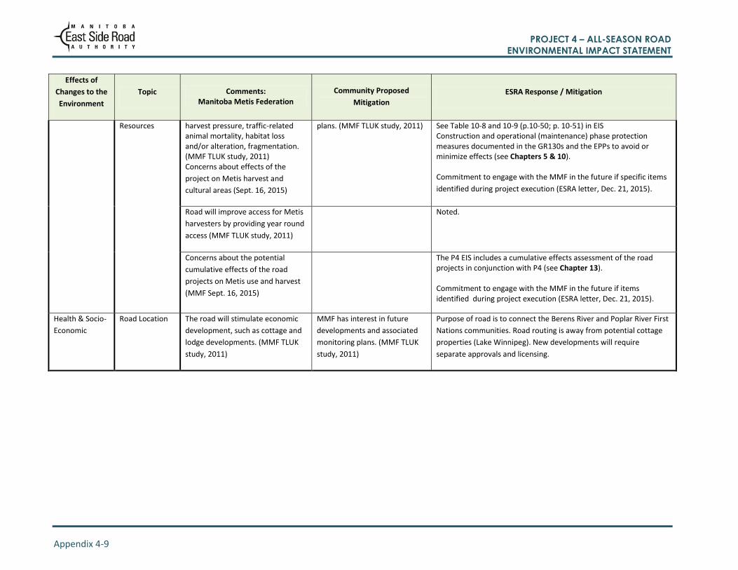
PROJECT 4 – ALL-SEASON ROAD ENVIRONMENTAL IMPACT STATEMENT
Appendix 4-9 Page 3
Effects of
Changes to the
Environment
Topic Comments: Manitoba Metis Federation
Community Proposed
Mitigation
ESRA Response / Mitigation
Resources harvest pressure, traffic-related animal mortality, habitat loss and/or alteration, fragmentation. (MMF TLUK study, 2011) Concerns about effects of the
project on Metis harvest and
cultural areas (Sept. 16, 2015)
plans. (MMF TLUK study, 2011) See Table 10-8 and 10-9 (p.10-50; p. 10-51) in EIS Construction and operational (maintenance) phase protection measures documented in the GR130s and the EPPs to avoid or minimize effects (see Chapters 5 & 10). Commitment to engage with the MMF in the future if specific items
identified during project execution (ESRA letter, Dec. 21, 2015).
Road will improve access for Metis
harvesters by providing year round
access (MMF TLUK study, 2011)
Noted.
Concerns about the potential
cumulative effects of the road
projects on Metis use and harvest
(MMF Sept. 16, 2015)
The P4 EIS includes a cumulative effects assessment of the road projects in conjunction with P4 (see Chapter 13). Commitment to engage with the MMF in the future if items identified during project execution (ESRA letter, Dec. 21, 2015).
Health & Socio-
Economic
Road Location The road will stimulate economic
development, such as cottage and
lodge developments. (MMF TLUK
study, 2011)
MMF has interest in future
developments and associated
monitoring plans. (MMF TLUK
study, 2011)
Purpose of road is to connect the Berens River and Poplar River First
Nations communities. Road routing is away from potential cottage
properties (Lake Winnipeg). New developments will require
separate approvals and licensing.


![Appendices Chapter 4[2]](https://static.fdocuments.in/doc/165x107/618f6191660b103f1b600d7c/appendices-chapter-42.jpg)