Chapter 3: Fire Regimes · PDF fileChapter 3: Fire Regimes . ... many regions and ecosystems...
14
27 Chapter 3: Fire Regimes Fire regimes are a critical foundation for understanding and describing effects of changing climate on fire patterns and characterizing their combined impacts on vegetation and the carbon cycle (Grissino Mayer and Swetnam 2000; Clark 1988; Schoennagel, Veblen, and Romme 2004; Pechony and Shindell 2010). In general a fire regime characterizes the spatial and temporal patterns and ecosystem impacts of fire on the landscape (Bradstock, Williams, and Gill 2002; Morgan et al. 2001; Brown and Smith 2000; Keeley et al. 2009). The two most important factors for determining fire regimes are vegetation type (or ecosystem) and weather and climate patterns. Fire history provides evidence of past relationships between fire and climate. That evidence makes it clear that changing climate will profoundly affect the frequency and severity of fires in many regions and ecosystems in response to factors such as earlier snowmelt and more severe or prolonged droughts (Westerling et al. 2006; Bowman et al. 2009; Flannigan et al. 2009; Littell et al. 2009; Morgan, Heyerdahl, and Gibson 2008; Kitzberger et al. 2007). Changing climate will alter the growth and vigor of existing vegetation, with resulting changes in fuel structure and dead fuel loads. General Concepts of Fire Regimes Fires in wildland vegetation display a range of fire behavior and fire characteristics that depend on factors such as the vegetation composition and fuel structure, stage of succession after previous fires or other disturbances, types of past management, climate and weather patterns, terrain, and landscape patterns (Morgan et al. 2001; Taylor and Skinner 2003; Wotton, Nock, and Flannigan 2010). The concept of a fire regime provides an integrated way of classifying the impacts of these diverse spatial and temporal patterns of fire and impacts of fire at an ecosystem or landscape level (Hardy et al. 1998; Morgan et al. 2001; McKenzie, Miller, and Falk 2011). Understanding the historic and potential fire regimes of different types of vegetation and the factors that can alter these fire regimes is important for understanding and predicting potential interactions between fire and climate. Not only does climate (as reflected in dominant weather patterns) directly affect the frequency, size and severity of fires, it also affects fire regimes through its influence on vegetation vigor, structure, and composition. On a local to regional scale, fire regimes may also be affected by terrain features, slope exposure, management regimes, landscape pattern, and ignition loads (both from lightning and from human impacts) (Taylor and Skinner 2003; Odion et al. 2004; Frost 2000; Agee 1993). At a minimum, fire regimes may be distinguished by how often fires typically occur (frequency, fire interval, fire rotation) and some assessment of impact on the ecosystem (e.g. mortality of overstory or surface vegetation). Some fire regime classifications include additional features such as fire characteristics (e.g. surface fire, crown fire, ground fire), the typical extent (or size) of fires (patch size), fire severity (impact of fire on the ecosystem; degree of mortality, depth of burn, fuel consumption, etc;), intensity or other measures of fire behavior (see box 3-1 for a discussion of terminology related to severity and intensity); seasonality, topographic position, and the degree of variability in fire characteristics within an ecosystem or fire regime type.
Transcript of Chapter 3: Fire Regimes · PDF fileChapter 3: Fire Regimes . ... many regions and ecosystems...

27
Chapter 3: Fire Regimes Fire regimes are a critical foundation for understanding and describing effects of changing climate on fire patterns and characterizing their combined impacts on vegetation and the carbon cycle (Grissino Mayer and Swetnam 2000; Clark 1988; Schoennagel, Veblen, and Romme 2004; Pechony and Shindell 2010). In general a fire regime characterizes the spatial and temporal patterns and ecosystem impacts of fire on the landscape (Bradstock, Williams, and Gill 2002; Morgan et al. 2001; Brown and Smith 2000; Keeley et al. 2009). The two most important factors for determining fire regimes are vegetation type (or ecosystem) and weather and climate patterns. Fire history provides evidence of past relationships between fire and climate. That evidence makes it clear that changing climate will profoundly affect the frequency and severity of fires in many regions and ecosystems in response to factors such as earlier snowmelt and more severe or prolonged droughts (Westerling et al. 2006; Bowman et al. 2009; Flannigan et al. 2009; Littell et al. 2009; Morgan, Heyerdahl, and Gibson 2008; Kitzberger et al. 2007). Changing climate will alter the growth and vigor of existing vegetation, with resulting changes in fuel structure and dead fuel loads.
General Concepts of Fire Regimes Fires in wildland vegetation display a range of fire behavior and fire characteristics that depend on factors such as the vegetation composition and fuel structure, stage of succession after previous fires or other disturbances, types of past management, climate and weather patterns, terrain, and landscape patterns (Morgan et al. 2001; Taylor and Skinner 2003; Wotton, Nock, and Flannigan 2010). The concept of a fire regime provides an integrated way of classifying the impacts of these diverse spatial and temporal patterns of fire and impacts of fire at an ecosystem or landscape level (Hardy et al. 1998; Morgan et al. 2001; McKenzie, Miller, and Falk 2011). Understanding the historic and potential fire regimes of different types of vegetation and the factors that can alter these fire regimes is important for understanding and predicting potential interactions between fire and climate. Not only does climate (as reflected in dominant weather patterns) directly affect the frequency, size and severity of fires, it also affects fire regimes through its influence on vegetation vigor, structure, and composition. On a local to regional scale, fire regimes may also be affected by terrain features, slope exposure, management regimes, landscape pattern, and ignition loads (both from lightning and from human impacts) (Taylor and Skinner 2003; Odion et al. 2004; Frost 2000; Agee 1993). At a minimum, fire regimes may be distinguished by how often fires typically occur (frequency, fire interval, fire rotation) and some assessment of impact on the ecosystem (e.g. mortality of overstory or surface vegetation). Some fire regime classifications include additional features such as fire characteristics (e.g. surface fire, crown fire, ground fire), the typical extent (or size) of fires (patch size), fire severity (impact of fire on the ecosystem; degree of mortality, depth of burn, fuel consumption, etc;), intensity or other measures of fire behavior (see box 3-1 for a discussion of terminology related to severity and intensity); seasonality, topographic position, and the degree of variability in fire characteristics within an ecosystem or fire regime type.

28
We do not have a consistent, agreed-upon and generally accepted fire regime classification as yet. This is partly a reflection of local and regional differences in vegetation and climate, and therefore in the types of fire regimes that occur. The ability to classify details of fire regimes also depends on the temporal and spatial scales being addressed and the types of data available. The fire regime characteristics of interest may also depend on the goals of a specific research study, the specific responses of individual ecosystems to fire (e.g. chaparral systems that may be dominated either by obligate seeders or by sprouting species), or the needs of managers in a particular area.
Fire Regime Classification The general temporal and spatial patterns of fire behavior and effects within a particular vegetation type or ecosystem over multiple fire cycles (decades to centuries) determine the fire regime over a specific period for any given ecosystem. Fire regimes are useful for comparing the
Text Box 3.1: Fire severity and fire intensity In discussing fire regimes it is important to recognize that there has been an evolution in the use of the terms “intensity” and “severity” in the fire effects and fire ecology literature. In the past, many authors used “intensity” to represent the ecosystem effects of fire (e.g. (Heinselman 1981), Kilgore, 1981). This usage can easily be confused with “fire-line intensity”, which has a very specific meaning with reference to fire behavior (the energy released per unit length of a fire front per unit time; generally in reference to flaming combustion). Measures of other physical factors that are aspects of fire intensity may include characterization of aspects of heat transfer, such as air temperature, soil temperature, or even cambial temperature; and characteristics of the flaming front (flame length, depth of flaming front, residence time or rate of spread, etc.). When combined with fire-line intensity, such factors can help to better explain effects of fire on vegetation and soils. Because factors such as duff moisture, fire rate of spread or residence time affect ecosystem impacts such as depth of burn, and duration and intensity of heating of stems, branches and foliage, fire-line intensity may not show a strong correlation with fire effects or severity, or with carbon emissions. This is especially true where there are extensive areas or localized pockets of smoldering combustion or where slow rates of spread lead to deeper heat penetration into the soil. In much of the literature, fire effects have been evaluated after a fire event with little or no information on the actual fire behavior. Recent authors (e.g. (Keeley 2009) and others) have urged the use of the term “severity” to describe the effects of fire on soil (sometimes called burn severity; see (Jain and Graham 2004) or on fuels and vegetation (sometimes called fire severity). Fire severity descriptors may include characterization of fuel consumption (what is burned), vegetation mortality, and measures such as bark char and foliage scorch. These latter are indicators of how the fire behaved and are often related to mortality. Intensity is then reserved for description of fire-line intensity, and may be supplemented with information of other important physical characteristics of fire (e.g. residence time, rate of spread, depth and duration of soil heating), all of which can help to explain the severity and secondary ecosystem effects of the fire. Fortunately, this is increasingly common practice. Although severity may be characterized in different ways, most often qualitatively, the use of this terminology lends more clarity to descriptions and discussions of fire regimes and ecosystem fire effects. There are valuable discussions of some of these issues in (Keeley 2009; Keeley et al. 2009; Jain and Graham 2004).

29
relative role of fire among ecosystems, for describing the degree of departure from historical conditions, and for projecting the potential effects of management activities, changing climate, or changing ignition patterns.
Before describing how fire regimes are classified, it is important to understand some of the terminology used to describe them (adapted from (Agee 1993; Dickmann and Cleland 2002; Keeley 2009)).
Ground fire: A fire that burns in surface organic materials such as peat or deep duff layers. Ground fires typically undergo a large amount of smoldering combustion and less active flaming than other types of fires. They may kill roots of overstory species because of prolonged high temperatures in the rooting zone.
Surface fire: Fires that burn only the lowest vegetation layer, which may be composed of grasses, herbs, low shrubs, mosses, or lichens. In forests, woodlands, or savannas surface fires are generally low to moderate severity and do not cause extensive mortality in the overstory vegetation.
Understory or sub-canopy fire: A fire that burns trees or tall shrubs under the main canopy. Depending on structure, this may also be called a surface fire.
Crown fire: A fire that burns through the upper tree or shrub canopy. In most cases the understory vegetation is also burned. Depending on species, a crown fire may or may not be lethal to all dominant vegetation. An example of this would be many shrub and broadleaf tree species that sprout from roots, root crowns or stem bases after their tops are killed. A crown fire may be continuous or may occur in patches within a lower severity burn.
Stand replacement fire: A fire that is lethal to most of the dominant above ground vegetation and substantially changes the vegetation structure. Stand replacement fires may occur in forests, woodlands and savannas, annual grasslands, and shrublands. They may be crown fires or high-severity surface fires or ground fires.
Mixed-severity fire: The severity of fires varies between nonlethal understory and lethal stand replacement fire with the variation occurring in space or time. In some vegetation types the stage of succession, the understory vegetation structure, the fuel condition and/or the weather may determine whether a low or high-severity (or surface or crown) fire occurs. In this case individual fires vary over time between low-intensity surface fires and longer-interval stand replacement fires. In others, the severity may vary spatially as a function of landscape complexity or vegetation pattern. The result may be a mosaic of young, older, and multiple-aged vegetation patches.
Fire frequency: The number of times that fires occur within a defined area and time period.
Fire return interval (or fire interval): The time between fires in a defined area, usually at the scale of a point, stand or relatively small landscape area. This is called Mean Fire Interval (MFI) in the LANDFIRE system, where it refers to the average number of years between fires in representative stands (Barrett et al. 2010).
Fire rotation (interval): the time required to burn an area equal to a defined area of the landscape. The entire area may not burn during this period; some sites may burn several times and others not at all. This is the same as fire cycle.

30
There have been numerous fire regime classifications for North America suggested in the literature. These vary in the number of types of fire regime described, the characteristics used to develop the classifications, and the types of ecosystems represented. The majority of classification systems focus primarily on forests, and few incorporate grasslands, desert vegetation, shrub ecosystems such as chaparral, or ecosystems with deep organic ground fuels (such as peat). A summary of several of these classification systems (Table 3.1) illustrates some of this diversity of classifications. Heinselman (Heinselman 1973; Heinselman 1981) described 6 fire regime types; three for varying frequency and severity of surface fires, and three for differing frequency of crown fires. Kilgore (Kilgore 1981) adapted this somewhat, and included a category for variable fire regimes that are dominated by frequent low-“intensity” surface fires with infrequent stand-replacement or high-‘intensity’ fires. Frost (Frost 2000) took a rather more complex approach. He mapped fire frequency regions at the time of European settlement for the eastern and western US. In developing these maps, he used a combination of landscape structural characteristics, fire frequency, and effects of fire on different vegetation layers. He then characterized fire regimes based on periodicity (regularity of the fire intervals), seasonality (the primary season of burn), frequency (seven classes of fire return intervals), and ecosystem effects (10 categories representing effects of fire on understory and overstory vegetation). The latter included categories such as light surface fire, grass reduction fires, understory thinning fires, canopy thinning, canopy replacement, and ground fires. The result was a characterization of over 30 different fire regimes. Brown and Smith ((Brown and Smith 2000); the “flora volume” of Table 3.1), use a simplified scheme that includes only three basic fire regimes. Nonetheless, this publication provides an excellent overview of the spatial patterns, frequency, and impacts of fire in major ecoregions of the US. Hardy et al. (1998) describe fire regimes in terms of the typical time between fires and whether fires are low-severity (with little impact on vegetation or soils and low fuel consumption), high severity (stand replacement fires where above-ground parts of dominant vegetation are killed) or mixed severity (where fires may occur at a range of severities on the landscape, in either space or time, as a function of weather, fuels, and other factors). The scheme proposed by Morgan et al. (2001) differs from that of Hardy et al. (1998) in distinguishing between non-lethal fires (e.g. grassland fires and some surface fires in forest systems), and stand replacement fires in forests and shrublands. The reasoning for this is that the Hardy et al. (1998) scheme does not work well for distinguishing stand replacement fires where vegetation mortality is high, from fires where aboveground parts of vegetation are burned, but belowground parts regenerate, or herbaceous vegetation recovers rapidly from seed. The fire regime classifications discussed above were all designed for North America—and primarily for the conterminous United States. Notably missing from these is specific mention of ground fires and smoldering fires in deep organic layers such as peat, which are common across the boreal zone (e.g (Turetsky et al. 2004; Turetsky et al. 2011)), and in some moist subtropical systems, such as the pocosin soils of the southeastern US (Reardon, Hungerford, and Ryan 2007) or the deep peat soils in Malaysia (de Groot et al. 2007). One of the first mentions of ground fire regimes was by Malcolm Gill (Gill 1975) in Australia, who had no experience with them, but recognized “below-ground fires” as important in other parts of the world. The large difference in approaches to classifying fire regimes described above speaks to a need for a broader consensus on the appropriate variables to include for describing fire regimes at various spatial and temporal scales, and perhaps for different purposes.

31
Spatial and Temporal Scale of Fire Regimes Fire regimes can be viewed over a wide range of temporal and spatial scales, ranging from several years to thousands of years and local to broadly regional. Knowledge of historical temporal and spatial patterns of fire is a key to characterizing and understanding fire regimes. The term “fire history” typically refers to some measure of past records or data that relate to the frequency of fire in a stand or a landscape, although inferences sometimes are drawn about the type or severity of these fires. It is when we move beyond simple fire history to describing the varying characteristics of fire across the landscape, and the interactions of fire with ecosystem structure and processes, that we move into the realm of fire regimes. Recent fire history (spatial and temporal patterns of fire on the landscape) has been recorded on fire maps or fire atlases, but these are often incomplete, and may only cover certain ownerships or parts of the landscape. In the past several years efforts have intensified to map fires that have occurred since (or shortly before) the advent of satellite remote sensing. Canada’s large fire database12 is the first nationwide effort of this sort. This database contains point locations for all fires larger than 200 ha from 1959-1999 and represents about 97% of the area burned during that
12 http://cwfis.cfs.nrcan.gc.ca/en_CA/lfdb
Table 3.1: Comparison of North American fire regime classifications by (Heinselman 1981) Kilgore (1981), Hardy and others (1998), Morgan and others (1998), and Brown and Smith (2000). Lines connect similar fire regime types. In parentheses, forest includes woodlands and grassland includes shrublands. Adapted from Figure 1-1 in Brown and Smith, 2000.

32
period (Stocks et al. 2002). The Canadian National Fire Database includes fire perimeters for all large fires, since 1980 and is annually updated13 (Parisien et al. 2006). In the United States, the Monitoring Trends in Burn Severity (MTBS) Project14 is using satellite data to map all large fires from 1984 to the present (Figure 3.1). This collaborative project also maps an index of fire severity (differenced Normalized Burn Ratio (dNBR)) within the fire perimeters using moderate resolution satellite data obtained before and after fires. The goal of this project is to provide nationally consistent data on fire perimeters and severity for all recent large fires in the United States (Eidenshink et al. 2007). Databases such as these provide a sound basis for quantifying fire occurrence, size, and (for the US) severity for use in modeling fire climate and fire vegetation interactions over the past several decades. The Alaska Fire Service has developed an excellent geospatial database of all fires since 193415. For fire location and size data prior to 1984 in the conterminous US, we will need to continue to rely primarily on the databases that are maintained by federal and state agencies. Unfortunately, these databases are often incomplete. They typically include data such as point locations for fire starts, area burned, and perhaps a general description of vegetation at the point of ignition. For fire perimeter maps, it becomes necessary to go to local offices, where maps of varying quality and reliability are stored. A longer period of record than the 30 to 100 years available for various products in Agency databases is required for understanding long-term interactions between fire and climate. As we go back further in time, fire history can only reliably be determined for portions of the landscape where some sort of fire indicators are recorded--either on the trees themselves (e.g. dendrochronology-based fire scar analysis), in stand structure (age distribution of stands where fire can be assumed to be the dominant disturbance factor), in charcoal deposits in soils, lakes, bogs, or ocean sediments (sediment charcoal analysis), or can be inferred from vegetation changes over long time periods (e.g. through pollen records). While each of these methods has its limitations, approaches using dendrochronology and sediment charcoal and pollen data can provide excellent insights into trends in vegetation, fire and fire/climate interactions over hundreds to thousands of years, and provide perspectives on variability, drivers of fire regimes, and fire/climate/vegetation interactions that are not possible from analysis of historical fire records which typically span decades rather than centuries or millennia (Whitlock et al. 2010). Numerous recent studies based on tree ring data or on historical fire records have shown strong relationships between past climate and fire frequency or extent (Brown et al. 2008; Heyerdahl, Morgan, and Riser II 2008; Heyerdahl, Brubaker, and Agee 2002; Heyerdahl, Brubaker, and Agee 2001; Kitzberger et al. 2007; Swetnam and Baisan 2003; Swetnam and Baisan 1996; Westerling et al. 2006). Such information can be used to extrapolate fire history to periods before actual fire data are available (Falk et al. 2011; Grissino Mayer and Swetnam 2000). Results of ecosystem specific studies relating fire to climate are discussed in Chapter 6.
13 http://cwfis.cfs.nrcan.gc.ca/en_CA/nfdb/poly 14 http://www.mtbs.gov/ 15 http://afsmaps.blm.gov/imf_firehistory/imf.jsp?site=firehistory
33
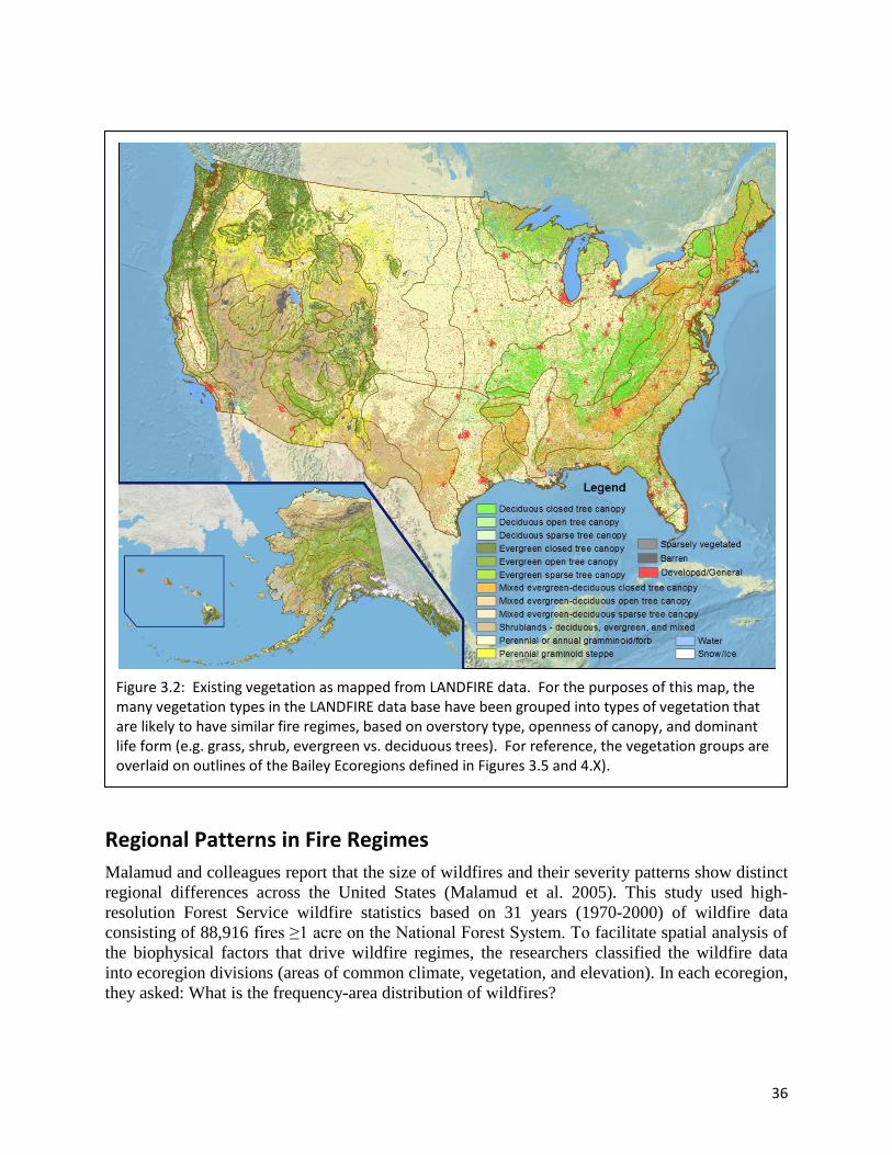
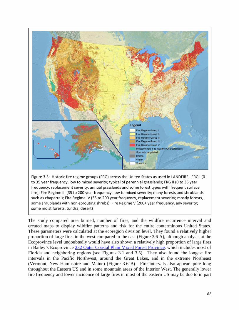
While fire history data are quite useful for understanding past fire regimes, changes in fire management policies and practices, demography, and climate mean that we cannot expect the same fire regimes to continue into the future. Models based on past relationships between fire and climate, fire and demographic change, and fire and management policies, or on past relationships between vegetation and climate show promise for helping us to project fire regimes into a future of changing climate and social environments. These concepts are discussed in detail in later chapters. LANDFIRE fire regimes Although there are numerous fire regime classifications presented in the literature, we will use the basic classification scheme of Schmidt et al. (2002) as modified in the current version of LANDFIRE ((Barrett et al. 2010); Table 3.2). This updated fire regime approach explicitly distinguishes between “stand replacement severity” and lower severity fires for all types of vegetation, improving its usefulness in grasslands and shrublands. We emphasize the LANDFIRE classification because both the historic fire regimes (Figure 3.2) and an assessment of departure of present fire regimes from the historic patterns (Figure 3.3) can be mapped for all US wildland ecosystems as part of the development of the LANDFIRE project and associated data bases. From inspection of Figures 3.1 through 3.4 broad regional variations in fire regimes, fire patterns, and departure from historic fire regimes are visible. For example,
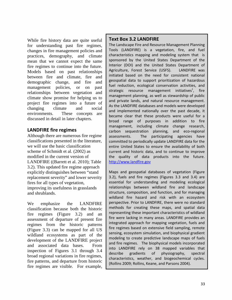
Text Box 3.2 LANDFIRE The Landscape Fire and Resource Management Planning Tools (LANDFIRE) is a vegetation, fire, and fuel characteristics mapping and modeling system that is sponsored by the United States Department of the Interior (DOI) and the United States Department of Agriculture, Forest Service (USFS). LANDFIRE was initiated based on the need for consistent national geospatial data to support prioritization of hazardous fuel reduction, ecological conservation activities, and strategic resource management initiatives1, fire management planning, as well as stewardship of public and private lands, and natural resource management. As the LANDFIRE databases and models were developed and implemented nationally over the past decade, it became clear that these products were useful for a broad range of purposes in addition to fire management, including climate change research, carbon sequestration planning, and eco-regional assessments. The participating agencies have committed to periodically update LANDFIRE data for the entire United States to ensure the availability of both current and historic data, and to continue to improve the quality of data products into the future. http://www.landfire.gov Maps and geospatial databases of vegetation (Figure 3.2), fuels and fire regimes (Figures 3.3 and 3.4) are essential for understanding and modeling ecological relationships between wildland fire and landscape structure, composition, and function, and for managing wildland fire hazard and risk with an ecosystem perspective. Prior to LANDFIRE, there were no standard methods for creating these maps, and spatial data representing these important characteristics of wildland fire were lacking in many areas. LANDFIRE provides an integrated approach for mapping vegetation, fuels and fire regimes based on extensive field sampling, remote sensing, ecosystem simulation, and biophysical gradient modeling to create predictive landscape maps of fuels and fire regimes. The biophysical models incorporated into LANDFIRE rely on 38 mapped variables that describe gradients of physiography, spectral characteristics, weather, and biogeochemical cycles. (Rollins 2009; Rollins, Keane, and Parsons 2004).

34
large fires in the past 10 years have been concentrated in the western states, Alaska, Georgia and Florida. During this period, no large fires were observed in other areas of the East. Examination of the fire, fire regime and vegetation maps shows that a high degree of departure of vegetation from historic conditions is not necessarily associated with increased hazard of large fires. This is especially evident in the eastern United States. Further, forested areas historically characterized by frequent low to moderate severity or mixed severity fires (FRG I and III; Figure 3.3) typically show at least moderate departure from historic conditions (FRCC II or III; Figure 3.4). Chapter 6 will discuss observed changes in vegetation and fire regimes in more detail for the various ecoregions of the US.
The LANDFIRE classification is also useful because it includes a general description of both typical fire frequencies, and fire severities, which are probably the most important types of information for detecting fire regime changes over time in ecosystems. Such data are a necessity if we are to evaluate and project effects of climate at regional to landscape scales. Further, the LANDFIRE databases are readily available to managers, and will be updated to reflect fire and other disturbance patterns. These data are freely available for download from www.landfire.gov, and can be integrated into geospatial databases for use in LANDFIRE analyses or other applications (such as analyses of potential climate change impacts). Another advantage of using
Group Frequency Severity Severity description
I 0 – 35 years Low/ mixed
Generally low-severity fires replacing less than 25% of the dominant overstory vegetation; can include mixed-severity fires that replace up to 75% of the overstory
II 0 – 35 years Replacement High-severity fires replacing greater than 75% of the dominant overstory vegetation
III 35 – 200 years Mixed / low Generally mixed-severity; can also include low-severity fires
IV 35 – 200 years Replacement High-severity fires
V 200+ years Replacement / any severity Generally replacement-severity; can include any severity type in this frequency range
Table 3.2: Fire regime groups used in the current LANDFIRE data bases. These groups have been modified from earlier versions (Hardy et al. 2001, Schmidt et al. 2002 ) to include low-severity fires in Fire Regime III and fires of any severity in Fire Regime V. Adapted from FRCC Guidebook, Version 1.2.1 (Anon. 2010).

35
the LANDFIRE classification is that the LANDFIRE databases also include geospatial data on the Bailey ecoregions and provinces ((Bailey 2008) Figure 3.5), which we will refer to throughout this synthesis. However, we will also use various terminology discussed above as needed to clarify the capacity of various vegetation types to regenerate above-ground vegetation from living roots or fire-adapted seeds after fire, distinguish between surface fire, ground fire, and crown fire, or discuss other aspects of fire regime such as seasonality that are appropriate to specific ecoregions or ecosystems.
Figure 3.1: Burn perimeters of all large fires in the United States from 1998 to 2008 as mapped, primarily from remote sensing data, for the Monitoring Trends in Burn Severity (MTBS) project. The database includes burns over 500 acres in the East, and burns over 1000 acres in the west. These thresholds were selected because they capture a high percent of the total burned area. The individual pixels have been enlarged to enable ready visibility of these data at a national scale. The map shown here includes an overlay of the Bailey ecoregions and the state boundaries.
36
Regional Patterns in Fire Regimes Malamud and colleagues report that the size of wildfires and their severity patterns show distinct regional differences across the United States (Malamud et al. 2005). This study used high-resolution Forest Service wildfire statistics based on 31 years (1970-2000) of wildfire data consisting of 88,916 fires ≥1 acre on the National Forest System. To facilitate spatial analysis of the biophysical factors that drive wildfire regimes, the researchers classified the wildfire data into ecoregion divisions (areas of common climate, vegetation, and elevation). In each ecoregion, they asked: What is the frequency-area distribution of wildfires?
Figure 3.2: Existing vegetation as mapped from LANDFIRE data. For the purposes of this map, the many vegetation types in the LANDFIRE data base have been grouped into types of vegetation that are likely to have similar fire regimes, based on overstory type, openness of canopy, and dominant life form (e.g. grass, shrub, evergreen vs. deciduous trees). For reference, the vegetation groups are overlaid on outlines of the Bailey Ecoregions defined in Figures 3.5 and 4.X).
37
The study compared area burned, number of fires, and the wildfire recurrence interval and created maps to display wildfire patterns and risk for the entire conterminous United States. These parameters were calculated at the ecoregion division level. They found a relatively higher proportion of large fires in the west compared to the east (Figure 3.6 A), although analysis at the Ecoprovince level undoubtedly would have also shown a relatively high proportion of large fires in Bailey’s Ecoprovince 232 Outer Coastal Plain Mixed Forest Province, which includes most of Florida and neighboring regions (see Figures 3.1 and 3.5). They also found the longest fire intervals in the Pacific Northwest, around the Great Lakes, and in the extreme Northeast (Vermont, New Hampshire and Maine) (Figure 3.6 B). Fire intervals also appear quite long throughout the Eastern US and in some mountain areas of the Interior West. The generally lower fire frequency and lower incidence of large fires in most of the eastern US may be due to in part
Figure 3.3: Historic fire regime groups (FRG) across the United States as used in LANDFIRE. FRG I (0 to 35 year frequency, low to mixed severity; typical of perennial grasslands; FRG II (0 to 35 year frequency, replacement severity; annual grasslands and some forest types with frequent surface fire); Fire Regime III (35 to 200 year frequency, low to mixed severity; many forests and shrublands such as chaparral); Fire Regime IV (35 to 200 year frequency, replacement severity; mostly forests, some shrublands with non-sprouting shrubs); Fire Regime V (200+ year frequency, any severity; some moist forests, tundra, desert)

38
greater population density and increased forest fragmentation. However, the differences among ecoregions are most likely primarily due to natural drivers, with frequent drought, flammable vegetation, and steep terrain producing conditions more conducive to large wildfires in much of the western US, and considerable summer rainfall and dominance by deciduous tree species in much of the East. The fire return interval differs markedly among ecoregions. For example, the fire cycles (typical fire return intervals) ranged from 13 years for the Mediterranean Mountains Division (M260) to 203 years for the Warm Continental Division (210).
Figure 3.4: Fire Regime Condition Class (FRCC) for the conterminous United States as used in LANDFIRE national database. FRCC is a metric of the degree of departure of current vegetation from the historical vegetation reference conditions simulated in LANDFIRE (Hann and Bunnell 2001; Hardy et al. 2001; Barrett et al. 2010; Holsinger and others 2006). The three condition classes describe low departure (FRCC 1), moderate departure (FRCC 2), and high departure (FRCC 3). Variables used in calculating FRCC are changes in species composition, structural stage, and canopy closure compared to modeled historical (pre-European) conditions (Barrett and others 2010); Holsinger and others 2006) (Rollins et al. 2007). The departure of current vegetation conditions shown in the LANDFIRE FRCC is only one component of the FRCC characterization described in Barrett et al. (2010) for doing local and regional assessments.

39
In other studies, gradients similar to those observed by Malamud et al. (2005) have been described and related to climate and vegetation. Turner and Romme (1994) describe wildfire occurrence gradients as a function of altitude and latitude. They attribute these gradients to broad climatic variation and note western and central regions tend to have frequent fires with forest
Figure 3.5: Ecoprovinces of the United States (Bailey 2008), mapped from the LANDFIRE database. Details on this map and the hierarchical system it represents are in the following chapter. The numbered Provinces, which are characterized by their dominant vegetation complexes are subdivisions of the 5 Domains and 14 major Divisions listed below. The M designator represents mountain areas within each Division. The domain and division boundaries are based on climate regimes, and topography: 100 POLAR DOMAIN 120 Tundra Division 130 Subarctic Division 200 HUMID TEMPERATE DOMAIN 210 Warm Continental Division 220 Hot Continental Division 230 Subtropical Division 240 Marine Division 250 Prairie Division
260 Mediterranean Division 300 DRY DOMAIN 310 Tropical/Subtropical Steppe Division 320 Tropical/Subtropical Desert Division 330 Temperate Steppe Division 340 Temperate Desert Division 400 HUMID TROPICAL DOMAIN 410 Savanna Division 420 Rainforest Division

40
stand structures dominated by younger trees, whereas the eastern region experiences longer inter-fire intervals and older stand structures. A statistical forecast methodology developed by Westerling et al. (2002) exploits these gradients to predict area burned by western United States wildfires, by ecoregion, a season in advance. Littell et al. (2009) found that climate drivers of synchronous fire differ regionally. They identified four distinct geographic patterns of Bailey Ecoprovinces across the West, each associated with a unique set of climate drivers of annual area burned by wildfire. For example, in northern mountain ecoprovinces (M332, M333), dry, warm conditions in the seasons leading up to and including the fire season are associated with increased area burned, suggesting that fuel condition that is dry vs. wet, was the key determinant of regionally synchronous fires. In contrast, in the southwestern dry ecoprovinces (313, 315, 321, 322), moist conditions the seasons prior to the fire season are more important than warmer temperatures or drought conditions in the year of the fire, suggesting that fuel abundance determined large fire years (See Figure 3.5 for Ecoprovince locations). Chapter 6 includes a detailed discussion of fire regimes for major vegetation types in each ecoregion of the US.
Figure 3.6: Wildfire patterns across the conterminous United States for years 1970 to 2000 for U.S. Forest Service wildfires, classified by ecoregion division. (A) Ratio of large to small wildfires. The darker the color, the greater the number of large fires. (B) Fire recurrence interval. The legend goes from dark red to white, representing “high” to “low” hazard (from Malamud et al. 2005).