
Chapter 3 - Alberta Agriculture and Forestrydepartment/deptdocs.nsf/all/epw11920/$FILE/3... ·...
19
57 Chapter 3.1 Field Assessment Identify five characteristics of site management to document during site evaluation. Describe key principles and methods for estimating the grade and length of slopes on a site. List two reasons why water bodies are important in nutrient management planning. Provide five examples of problem soil conditions to document during a site assessment. Identify and decide if additional physical features impact nutrient management planning. • • • • • learning objectives
Transcript of Chapter 3 - Alberta Agriculture and Forestrydepartment/deptdocs.nsf/all/epw11920/$FILE/3... ·...

57
Chapter3.1Field Assessment
Identify five characteristics of site management to document during site evaluation.
Describe key principles and methods for estimating the grade and length of slopes on a site.
List two reasons why water bodies are important in nutrient management planning.
Provide five examples of problem soil conditions to document during a site assessment.
Identify and decide if additional physical features impact nutrient management planning.
•
•
•
•
•
learning objectives

58
Field Assessment
Important TermsTable 3.1.1 Key Terms and Definitions
Term Definition
Bulk Density, Soil The mass of dry soil per unit bulk volume. Bulk volume is determined before the soil is dried to constant mass.
Deep Ripping A tillage process aimed at amending/shattering sub-surface compacted soil layers typically at depths greater than 30 cm.
Discharge Site The area of the field over which groundwater and its associated salts emerge at the soil surface.
Montmorillonite Clay Dominant ‘type’ of clay in Alberta soils. Characterized by swelling and shrinkage when wetted and dried.
Recharge Site The area of the field over which water is absorbed and added to the zone of saturation.
Runoff The portion of the total precipitation or surface water that does not enter the soil, rather it flows overland.
Water Holding Capacity The ability of the soil to hold water. The water-holding capacity of sand is considered low, while that of clay is considered high.
The first step in nutrient management planning is to gather information about site characteristics and how they impact nutrient management. Sloping land, problem soils and the presence of water bodies all influence the fate of applied nutrients and must be considered in NMP’s.
Five characteristics to identify during a site assessment are:
Soil physical properties
Slope
Water bodies
Problematic soil conditions
Past and current site management
Soil Physical PropertiesSoil physical properties include texture and structure. Understanding how these properties influence runoff and leaching potential, erosion susceptibility, nutrient retention, crop establishment and growth and the risk of compaction and crusting will enable more site-specific nutrient management decisions.
•
•
•
•
•
Soil Texture
Soil consists of four basic components: organic matter, minerals, air and water (Figure 3.1.1). The mineral component of soil is made up of sand, silt and clay particles (Figure 3.1.2). Soil texture is the percentage (by weight) of sand, silt and clay in the mineral fraction of a soil.
Figure 3.1.1 General Composition of Mineral Soils

59
Chapter 3.1
A soil aggregate is formed when soil particles adhere to one another such that they behave as a single unit.
s i d e b a r
Based on Canadian Soil Classification Group, 1998Figure 3.1.2 Relative Size of Different Types of Particles
Sand-sized particles can be seen with the naked eye or felt as grit when rubbed between the fingers. Sand has large and uneven surfaces that limit contact between adjacent particles. Consequently, soils dominated by sand do not form stable aggregates. Rather, these fragile aggregates are easily disrupted, suffer from poor structure, and are prone to wind erosion. The large pores formed between sand particles allow rapid water infiltration, but reduce overall water holding capacity.
Silt-sized particles cannot be seen with the naked eye, or felt when rubbed between the fingers. Silt particles cling together better than sand; however, silt contributes
little to the formation of stable aggregates in soil. The pores formed between silt particles are smaller than those formed by sand, which results in slower water infiltration and higher water holding capacity.
Clay-sized particles are only visible through electron microscopy. Clay’s adhesive properties contribute to the formation of stable soil aggregates that are more resistant to physical disturbance (e.g., cultivation). Pore spaces between clay particles are even smaller than in silt, but the total pore volume is considerably larger. This slows water infiltration but significantly increases water-holding capacity. Clay has a huge surface area to volume ratio relative to larger sand and silt particles (Figure 3.1.3). Soils dominated by clay are prone to swelling when wet and cracking when dry.
Adapted from Brady and Weil, 2000Figure 3.1.3 Relationship Between Surface Area and Volume
Sand(0.05 - 2.0 mm)
Silt(0.05 - 0.002 mm)
Clay(> 0.002 mm)
Soil Particles Diameter (mm)
Very coarse sand
Coarse sand
Medium sand
Fine sand
Very fine sand
Silt
Clay
Fine clay
2.0 - 1.0
1.0 - 0.5
0.50 - 0.25
0.25 - 0.10
0.10 - 0.05
0.05 - 0.002
< 0.002
< .00002
8 cmAVolume8 cm x 8 cm x 8 cm = 512 cm3
Surface area8 cm x 8 cm x 6 surfaces = 384 cm2
Surface area/volume ratio384 512 = 0.75 /÷cm cm cm cm2 3 2 3
Volume2 cm x 2 cm x 2 cm x 64 = 512 cm3
Surface area2 cm x 2 cm x 6 x 64 = 1,536 cm2
Surface area/volume ratio1,536 512 = 3 ÷cm cm cm /cm2 3 2 3
B 2 cm

60
Field Assessment
Soil texture is determined in the laboratory through particle size analysis or manual texturing (Figure 3.1.5). Based on the proportions of mineral content in a soil, the soil textural triangle is used to determine a soil’s textural class (Figure 3.1.4). For example, clay dominated soils are defined as fine textured, while sand dominated soils are coarse textured.
Adapted from Glossary of Soil Science Terms, 1976 Figure 3.1.4 The Soil Textural Triangle
more info
Before applying manure to a field, AOPA requires a one-time
laboratory test to determine soil texture. Details on AOPA soil testing requirements for nutrient management are discussed in Chapter 3.3.
Determining Soil Texture Using the Soil Textural Triangle
The particle size separation of three samples yielded the following percentages of sand and clay:
Sample % Sand % ClayA 18 20B 2 36C 35 27
Based on Figure 3.1.4, sample A is a silt loam, B is a silty clay loam, and C is a loam.

61
Chapter 3.1
Adapted from McNeil et al., 1998aFigure 3.1.5 Manual Method for Determining Soil Texture

62
Field Assessment
Management Implications Coarse textured soils have a higher risk for nutrient leaching into ground water because of higher infiltration rates and lower water holding capacity than medium or fine textured soils. This risk increases when groundwater is present at relatively shallow depths. Yield potential may also be lower on coarse-textured soils because of reduced water holding capacity and nutrient retention capacity. Excessive tillage should be avoided on coarse textured soils because of higher wind erosion risks.
Fine textured soils on sloping land adjacent to surface water bodies are at higher risk for runoff transport of nutrients to water bodies. These soils may have better yield potential due to higher nutrient and water holding capacities compared to medium or coarse textured soils. However, they are susceptible to compaction from field traffic when wet, reducing water infiltration and increasing runoff potential. These risks should be considered when planning and conducting field operations.
» Soil Structure
Soil structure describes how individual soil particles clump together or aggregate. It is the result of several factors including: soil texture, root growth, decomposition, soil organic matter, freeze-thaw processes and soil micro and macro-organism activity. These physical and biological forces fracture clods, bind particles together and create channels for water movement and root growth. Cultivation tends to break down soil aggregates and destroy soil structure.
Soil structure is best determined by visual assessment. The Canadian System of Soil Classification (1998) describes four basic types of soil structure: structureless, block-like, plate-like and prism-like (Figure 3.1.6).
The soils of western Canada are dominated by montmorillonite clays, which increase the CEC of the soil. Since cation exchange plays an important role in crop nutrition, soil texture then influences soil fertility.
s i d e b a r

63
Chapter 3.1
Type KindStructureless: No observable aggregation or clear orderly arrangement around natural lines of weakness.
Single grain structure: Loose mass of individual particles. Commonly found in sandy soils.
Massive structure: Soil appears in large clods with no visible structure.
Block-like: Soil particles are arranged around a point and bounded by flat or rounded surfaces.
Blocky (angular blocky): Faces are rectangular and flattened. Faces intersect at relatively sharp angles. Sub-angular blocky: Faces are a mixture of rounded and flattened. The edges are mostly rounded.
Granular structure: Sphere-shaped and characterized by rounded edges.
Plate-like: Soil particles are arranged on a horizontal plane bounded by flat surfaces.
Platy structure: Flat plates of soil that lie horizontally.

64
Field Assessment
Prism-like: Soil particles are arranged on a vertical axis bounded by flat vertical surfaces.
Prismatic structure: Well-defined vertical columns of soil with sharp edges.
Columnar structure: Vertical columns of soil with rounded edges, and are flat-topped, round-topped, or irregular.
Sources: Canadian Soil Classification Group, 1998; Brady and Weil, 2000Photos courtesy National Aeronautical and Space Administration (NASA)
Figure 3.1.6 Types, Kinds, and Classes of Soil Structure
Implications of Soil Structure for Nutrient ManagementPoorly structured (e.g., structureless or platy) soils have physical properties that may limit crop production, increase runoff and increase the risk of water erosion. In contrast, well-structured (e.g., granular) soils with stable aggregates promote better root development, enhance nutrient uptake and improve productivity. These factors must be considered when identifying field management strategies.
Identifying both surface and subsurface soil characteristics is important for managing nutrient leaching and runoff risk. Fields may have soil layers of
» varying thickness with unique texture and structure. This can have a big impact on water infiltration rate (Figure 3.1.7). Soils prone to rapid water infiltration pose a higher risk of nutrient leaching, while those with poor infiltration have a higher risk of nutrient transport through runoff. Fields may be at risk of both if they have a layer of fine textured over coarse textured soil. This could result in runoff during rapid rainfall events and deeper nutrient leaching because of poor subsoil water holding capacity.

65
Chapter 3.1
more info
The grade of slopes adjacent to water bodies influences the required
setback distance for certain manure application conditions under AOPA (Chapter 4.4).
Adapted from Soil Conservation Service, 1991Figure 3.1.7 Relative Rate of Water Infiltration of Various Soil Structures
Practices that enhance or promote good soil structure include:
applying manure to the land
including perennial forage crops in rotation
returning crop residues to the land
direct seeding or carefully managing tillage operations
applying calcium-based amendments
deep ripping of soils with subsoil hardpans
avoiding field traffic during wet soil conditions
•
•
•
•
•
•
•
SlopeSloped land presents a natural risk of runoff and erosion. Erosion from slopes adjacent to water bodies can increase nutrient transport to surface water. The grade and length of slope influences the potential of such risks.
Slope Grade
Slope grade is a ratio of the change in elevation over a given horizontal distance (Figure 3.1.8). In many fields slopes are not uniform, but instead have dips and bumps along their length. For practical purposes, nutrient management planning is concerned with the average grade of a slope.
Figure 3.1.8 Measurement of Slope
Soil sampling strategies (discussed in Chapter 3.3) are also influenced by the general topography and presence of slopes in a field.
s i d e b a r

66
Field Assessment
(rise)2 + (run)2Slope length =
(6 m)2 + (47 m)2=
36 m2 + 2209 m2=
2245 m2=
47.4 m=
= rise ÷ run x 100Slope grade6 m ÷ 47 m x 100=12.8%=
Calculating Grade and Length of SlopeUsing a GPS unit, it is determined that a slope in one particular field has a run of
47 m and a rise of 6 m. The grade on this slope would be:
The approximate grade of this slope is 13% and the length is 47 m.
There are several practical methods to determine slope grade including visual approximation, using a clinometer, and using a GPS. Choosing a method will depend on availability of technology and the level of precision required.
Visual ApproximationThe least precise, but simplest method for approximating slope is visual evaluation. Visual evaluation is useful for determining whether slope exceeds certain critical threshold grades (e.g., slope greater or less than 4%). This method is used in the Alberta Environmental Farm Plan field assessment process.
»
ClinometersA relatively precise, yet simple method for estimating slope is using a clinometer (Figure 3.1.9). This tool measures the angle or percent (or both) grade of a slope.
Photo courtesy National Resource Conservation ServiceFigure 3.1.9 Slope Grade Measurement Using a Clinometer
Clinometers range in price from $20 to more than $300, depending on the sophistication of the instrument. Designs for simple, inexpensive homemade clinometers can be found online.
GPSA GPS unit can be used in the field to determine slope (Figure 3.1.10). Most GPS units provide relatively accurate coordinates that can be used to calculate the grade and length of slope (see equations in Figure 3.1.8).
»
»
tip
To get an accurate slope reading, pick a reference target that is clearly
visible at eye height. The line of sight should run as close to parallel with the slope grade as possible. The reference target can be anything from a post, a vehicle or another person.
tip
Several post secondary training institutions offer short courses on the use of
Global Positioning System (GPS) technology for agricultural and land management applications. Contact your local institution to find out about upcoming learning opportunities.

67
Chapter 3.1
Figure 3.1.10 Using GPS Technology to Determine Length of Slope
Slope Length
Unlike grade, there are no regulations on slope length so there is less need for a precise measurement. There are a number of simple ways to estimate slope length including:
Estimate the length of the slope in relation to a known distance.
Pace out short slopes. If stride-length is known and consistent, pacing will provide a reasonable estimate of distance covered. Keep in mind that sloping land will affect a normal stride.
Use a vehicle’s odometer. This strategy should not be used on sites with steep slopes where there is a risk of rollover.
•
•
•
Slope Length in Relation to a Known DistanceA quarter section of land is approximately 800 m by 800 m (half a mile by half a mile). Based on an in-field assessment and aerial photos, a slope travels at least half the length of a quarter section. Therefore, the length on this slope would be at least 400 m.
Pacing out Slope Length A landowner travels 10 paces up a slope at a distance of 8.8 m. It takes him 122 paces
to travel the entire slope from base to crest. The estimated length of the slope is:
Slope length = average distance travelled per pace x length of slope (in paces)
= 8.8 m ÷ 10 paces x 122 paces
= 0.88 m per pace x 122 paces
= 107.4 m is the estimated length of this slope
Management ImplicationsThe grade and length of slope are natural risk factors for soil erosion due to runoff. Topography also influences the pattern of surface water flow.
In general, runoff and erosion risks increase as slope grade increases. Erosion redistributes nutrients (dissolved and sediment-bound) and organic matter within the landscape. Erosion from slopes adjacent to water bodies can increase nutrient transport to surface water. Choosing appropriate land management practices to mitigate erosion depends on whether runoff flow is concentrated or more generalized (e.g., grassed waterway versus vegetative filter strip).
»
more info
See template for a simple homemade clinometer (along with instructions
for use) in Appendix 3.

68
Field Assessment
Redistribution of nutrients and surface water flow patterns due to topography will influence productivity, creating areas of higher and lower productivity within a field. This presents an opportunity to use landscape specific management strategies such as management zoning and variable rate nutrient application. These strategies offer the potential for controlled nutrient placement to optimize utilization, minimize accumulation, and decrease the risk of loss.
Water Bodies
The location of water bodies, in or adjacent to fields that receive nutrient application, is a critical feature to identify during a site assessment. Water bodies include, but are not limited to:
active or abandoned wells
springs
sloughs
lakes
rivers
streams
aquifers
wetlands
Management ImplicationsWhenever nutrients are applied near a water body there is a potential risk to water quality. According to AOPA, manure application setbacks apply only to “common bodies of water”—i.e., water bodies that are not entirely contained on land controlled by a landowner. However, for good environmental stewardship it is important to protect all water bodies.
•
•
•
•
•
•
•
•
»
Problem Soil ConditionsProblem soil conditions can limit the productive potential of a site. Some common conditions that should be identified include:
Salt-affected soils
Soil pH
Solonetzic soils
Organic soils
Eroded soils
Salt-Affected Soils
Saline soils have high concentrations of soluble salts in surface soil layers. These soils are identified through a combination of soil testing and visual inspection of a site.
Management ImplicationsSoil salinity can limit crop yield by impairing a crop’s ability to efficiently use soil moisture. Crops vary in their sensitivity to saline conditions. Salt-sensitive crops have less yield potential and lower nutrient requirements than more salt-tolerant crops. It may be advantageous to include more salt-tolerant perennial species such as tall and slender wheatgrass in rotations. Six-row barley is the most tolerant annual crop followed by two-row barley, canola and wheat. Depending on the cause of the salinity issue, specific management to address recharge and discharge sites within the field may be required.
•
•
•
•
•
»
The salt tolerance of various crops grown in Alberta is presented in Table 3.4.5 (Chapter 3.4).
s i d e b a r
The generalized pH classification of soils is discussed in Chapter 3.4.
s i d e b a r

69
Chapter 3.1
Soil pH
In Alberta, acid soils occur frequently in the central Peace River regions (Figure 3.1.11). Alkaline soils are more common in the Brown and Dark Brown soil zones and on eroded hilltops.
Adapted from Kryzanowski, 1996Figure 3.1.11 Occurrence of Acid Soils in Alberta
Since pH can vary considerably within individual fields, regional generalizations about soil pH conditions are not adequate for site-specific nutrient management. As such, field specific determination of pH is important. If pH is identified as a problem, a detailed sampling strategy can be used to determine the extent and severity of pH problems within the field.
Management ImplicationsSoil pH should be considered when making management decisions for a number of reasons:
Extreme pH conditions will limit crop growth unless tolerant crops are selected. Most crops prefer pH in the neutral range (pH 6.5 to 7.0).
Acidic conditions reduce the rate of organic matter decomposition, which affects the rate of nutrient release from organic sources.
Alkaline or acidic soil conditions can reduce nutrient availability (see Figure 2.2.4, Chapter 2.2). Nutrient management planning should factor in reduced crop yield potential and nutrient availability on acid or alkaline soils.
Soil pH reduces the rate of breakdown of some herbicide residues. This could result in herbicide injury to sensitive crops following in rotation. Therefore, when planning crop rotations consider possible herbicide carry over.
At elevated soil pH (greater than 7.5), the natural equilibrium between ammonium (NH4
+) and ammonia (NH3) shifts in favor of NH3, which can be lost by volatilization. Therefore, incorporation of broadcast manure and fertilizer is critical on high pH soils to minimize NH3 losses.
Nodulation of many legume crops is impaired in low pH soils. This reduces the amount of N fixed by the crop and increases the need for supplemental N inputs.
»
•
•
•
•
•
•
more info
For more information on managing acid soils, check out these factsheets,
which can be ordered from the AF Publications Office or searched by Agdex number on Ropin’ the Web:
1996. Liming acid soils. Agdex 534-1.
2002. Wood ash: An alternative liming material for agricultural soils. Agdex 534-2.
•
•

70
Field Assessment
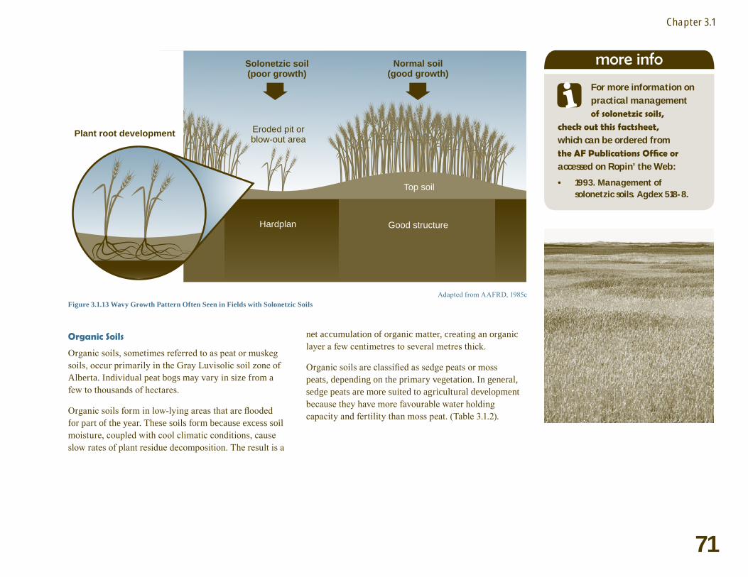
Solonetzic Soils
Solonetzic soils are found primarily in eastern Alberta, between Vermilion and Brooks. Solonetzic soils are naturally high in exchangeable sodium, characterized by the presence of a tough, impermeable hardpan layer found 5 to 30 cm or more below the surface (Figure 3.1.12).
Figure 3.1.12 Profile of a Solonetzic Soil
Management ImplicationsSolonetzic soils severely restrict root penetration and water infiltration, resulting in poor crop growth and reduced tolerance to drought or flood conditions. Solonetzic soils exhibit in-field variation in topsoil depth, pH, fertility and subsoil characteristics. Variation in topsoil depth above the hardpan layer is largely responsible for the wavy pattern of crop growth observed on solonetzic soils (Figure 3.1.13). These soils have natural productivity constraints, which should be considered when making nutrient management decisions. Some management practices can improve the productivity of solonetzic soils (e.g., subsoil cultivation or deep ripping), however, these are not applicable to all situations.
»more info
For more detailed information on salinity types and practical
management check out these publications, which can be ordered from the AF Publications Office or searched by Agdex number on Ropin’ the Web:
1997. Perennial crops for recharge control of saline seeps. Agdex 518-13.
1997. Annual crops for recharge control of saline seeps. Agdex 518-14.
1997. Perennial crops for salinity control in discharge areas. Agdex 518-15.
1998. Structural controls for dryland saline seeps. Agdex 518-16.
2000. Dryland saline seeps: types and causes. Agdex 518-12.
2001. Salt tolerance of plants. Agdex 518-17.
•
•
•
•
•
•
71
Chapter 3.1
Adapted from AAFRD, 1985cFigure 3.1.13 Wavy Growth Pattern Often Seen in Fields with Solonetzic Soils
Good structure
Top soil
Normal soil(good growth)
Solonetzic soil(poor growth)
Eroded pit orblow-out area
Hardplan
Plant root development
Organic Soils
Organic soils, sometimes referred to as peat or muskeg soils, occur primarily in the Gray Luvisolic soil zone of Alberta. Individual peat bogs may vary in size from a few to thousands of hectares.
Organic soils form in low-lying areas that are flooded for part of the year. These soils form because excess soil moisture, coupled with cool climatic conditions, cause slow rates of plant residue decomposition. The result is a
net accumulation of organic matter, creating an organic layer a few centimetres to several metres thick.
Organic soils are classified as sedge peats or moss peats, depending on the primary vegetation. In general, sedge peats are more suited to agricultural development because they have more favourable water holding capacity and fertility than moss peat. (Table 3.1.2).
more info
For more information on practical management of solonetzic soils,
check out this factsheet, which can be ordered from the AF Publications Office or accessed on Ropin’ the Web:
1993. Management of solonetzic soils. Agdex 518-8.
•

72
Field Assessment
Table 3.1.2 Physical and Chemical Characteristics of Organic Soils
Organic Soil Type
Fibre Content
Moisture Holding Capacity (% of dry weight)
Electrical Conductivity (dS/m)
pHTotal N
(% by weight)Sedge Peat Low 400-600 0.5 – 3.5 5.0 – 8.5 2.0 – 3.0Moss Peat Very high 1000-1500 0.2 – 0.4 3.5 – 5.5 0.5 – 1.0
Source: AAFRD, 1985e
Management ImplicationsThe natural characteristics of organic soils present some challenges to agricultural production and nutrient management. Organic soils are often waterlogged during certain times of the year (e.g., spring) because they are associated with high water tables. As a result of these characteristics, organic soils experience greater nutrient losses through leaching and denitrification, and impeded crop establishment and early growth.
Organic soils are very high in organic matter; therefore, the carbon to nitrogen (C:N) ratio is large. This slows the release of N from organic matter to the point where N available for plant uptake can be limited. Organic soils are also prone to micronutrient deficiencies, particularly copper, which may reduce productivity.
If a field has small areas of organic soil and the organic layer is thin enough, it may be feasible to incorporate and mix it with the mineral layers below. This action will improve the balance of organic and mineral fractions in the surface soil layer and potentially increase the rate of decomposition. This action will not, however, affect the water table or the risk of waterlogging. If large areas of organic soil dominate a field, the cropping options are typically limited to more flood tolerant forages, such as Garrison creeping foxtail, reed canary grass and timothy.
» Eroded Soils
Eroded soils are unproductive areas that form largely as a result of erosion or excessive cultivation. Topsoil is stripped from the surface exposing the dense, compact, low organic matter subsoil. Productivity on these areas may be low due to poor fertility and restrictive soil physical properties. Exposed subsoils will have little or no soil development and usually have elevated pH. Eroded areas are also susceptible to drought conditions due to their poor water holding capacity and limited permeability.
Management ImplicationsEroded soils have several problems that limit yield potential such as crusting, restricted root growth, limited water availability, low fertility and pH extremes (high or low).
The hard, compact nature of exposed subsoils can negatively impact yield potential by restricting root growth and surface crusting. Emerging plants have a difficult time pushing through the surface crust to access light and extending roots through the soil to reach nutrients. The compact nature also increases the bulk density of the soil, making it difficult for water to infiltrate and reduces water availability for crop growth.
»
more info
More information on practical management of erosion and eroded
soils, check out these factsheets, which can be ordered from the AF Publications Office or searched by Agdex number on Ropin’ the Web:
AF. 1997. An introduction to water erosion control. Alberta Agdex 572-3.
AF. 1998. Emergency wind erosion control measures. Adgex 572-1.
AF. 1998. An introduction to wind erosion control. Agdex 572-2.
AF. 2002. Fertilizing eroded knolls. Agdex 541-2.
•
•
•
•

73
Chapter 3.1
The loss of nutrient-rich organic matter from eroded soils greatly reduces soil productivity. The addition of fertilizer and manure can enhance the productivity of these areas by adding nutrients and organic matter. Landscape-specific management strategies, such as variable rate technology and targeted manure application, can be used to improve productivity and soil quality in these areas.
Eroded soils typically have pH issues. Extremes in pH can affect the availability and risk of loss of some nutrients. For example, alkaline soil conditions reduce the availability of phosphorus, and promote higher losses of nitrogen (N) in the form of ammonia from fertilizer or manure.
Strategies for reclaiming eroded areas and improving soil structure include: the addition of manure, returning or maintaining crop residues, direct seeding, or the establishment of perennial forages. These areas should also be managed using erosion control measures to prevent further degradation.
Past and Current Site ManagementEvaluating past and current management practices will help in identifying necessary changes to reduce environmental risk or improve site productivity.
Key Information on Site Management
Improved drainage: The presence of tile drainage or ditching significantly increases the risk of nutrient loss or movement from a field.
Recent fertilizer application history: Document application history including type, application rate, timing of application (e.g., fall versus spring) and method and timing of incorporation.
Manure application history: Document manure source (e.g., beef, hog, etc.), manure
•
•
•
test information, application rate, timing of application (e.g., fall versus spring) and method and timing of incorporation. Account for residual nutrient availability when planning future nutrient applications, particularly if manure has been applied on the site within the last two years.
Tillage practices: Fields under direct seeding or other reduced tillage systems have less risk of nutrient runoff losses. However, the incorporation of manure, particularly solid manure, on these sites may not be practical. Without adequate incorporation, volatile N losses from the manure could be substantial.
Crop rotation: Short or long-term cropping plans for a site can reveal opportunities for reducing the risk of nutrient loss, building soil organic matter and determining expected nutrient removal by future crops. Account for anticipated nutrient release from past green manure crops in the rotation.
Issues relating to row crops: Row crop management increases the risk of runoff, erosion and soil compaction.
Presence of irrigation: Fields under irrigation management have higher yield potential and can support a greater variety of crops, but are also at increased risk for nutrient leaching and runoff. Be aware of potential soil quality implications and the addition of nutrients present in irrigation water.
Past soil test information: Historical soil test results can help identify chronic soil problems (e.g., salinity, acidity) that may affect crop selection.
Existing control structures or beneficial management practices: In some situations, structures or practices may already be in place to minimize erosion and nutrient loss. Evaluate these to identify any necessary improvements. In some cases, effective practices or structures may allow for manure applications that otherwise would have been restricted under AOPA.
•
•
•
•
•
•
74
Field Assessment
Other Features of InterestDuring the site assessment, document any other site features that might affect crop productivity. These features may impact the ability to apply nutrients or crop protection products, or these features may affect the environmental risk associated with producing a crop on that site. Identifying additional site features is particularly important if custom applicators are unfamiliar with the site. Awareness of these features provides the applicator with an understanding of the risks and liabilities associated with the site.
Some examples of additional features to identify include:
drainage pattern or structures (e.g., tile drainage systems)
public roads or ditches that run adjacent to the site
irrigation structures
wildlife habitat
presence of endangered species on the site (including endangered plant species)
rock outcroppings
oil well sites and road allowances
proximity to neighbours (if there is a risk of nuisance arising from field operations)
presence of damage from burrowing animals (e.g., pocket gophers, ground squirrels, badgers, etc.)
areas of compacted soil or soils with drainage issues
woodlots
above-ground or buried utilities
To determine whether a feature should be included in the site assessment portion of the nutrient management plan, consider the following questions:
•
•
•
•
•
•
•
•
•
•
•
•
Questions to Determine Relevance of a FeatureWill the feature affect the rate, timing, or pattern of manure or fertilizer application?Does the feature increase the environmental risk associated with producing a crop on the site under the proposed management system?Will this feature contribute to nuisance issues resulting from field operations involved in producing a crop on the site?Will it be necessary to implement a management practice to offset the impact of the feature?Does the feature present a potential hazard or obstacle to any equipment that will be used in the production of a crop on the site?
If the answer is “yes” to any of the above questions, document and incorporate the feature into the planning and decision-making process.
1.
2.
3.
4.
5.

75
Chapter 3.1
The five features of site management to document are: soil physical properties (texture and structure), slope, water bodies, problematic soil conditions and site management practices.
Slope grade is the relationship between rise and run, and can be determined using clinometer or GPS technology.
Slope length can be determined by visual estimation, pacing the distance or vehicle odometer.
Water bodies need to be identified because of potential adverse effects of nutrients on water quality and legislated setback distances under AOPA.
•
•
•
•
Problematic soil conditions that affect productivity include: salinity, extremes in soil pH, solonetzic soils, organic soils and eroded areas.
Some additional physical features that could be identified in a site assessment includes: public roads or ditches, irrigation structures, wildlife habitat, rock outcroppings, proximity to neighbours, areas of compacted soil or soils with drainage issues.
A feature should be included in a site assessment if it will affect the rate, timing or pattern of nutrient application; if it increases the environmental risk of field operations; if it requires in an alternative management practice; or if it is a potential hazard or obstacle to field equipment.
•
•
•
summary