
Chapter 27: Response to Comments - Welcome to NYC.gov...Chapter 27: Response to Comments A....
55
Chapter 27: Response to Comments A. INTRODUCTION This chapter summarizes and responds to all substantive comments on the Draft Environmental Impact Statement (DEIS), issued on September 5, 2008, for the proposed 363-365 Bond Street project. Oral and written comments were received during a public hearing held by the New York City Planning Commission (CPC) on January 7, 2009. Written comments were accepted from issuance of the DEIS through the public comment period, which ended January 20, 2009. Section B alphabetically lists the elected officials, community boards, public agencies, organizations, and individuals that provided relevant comments on the DEIS. Section C summarizes these relevant comments and responds to each of them. Comments are organized by subject matter and generally follow the chapter structure of the DEIS. Where more than one commenter expressed a similar view, the comments have been grouped and addressed together. A number of commenters did not make specific arguments related to the proposed approach or methodology for the impact assessments. Others suggested editorial changes. Where relevant and appropriate these edits, as well as other substantive changes to the DEIS, have been incorporated into the Final EIS (FEIS). B. LIST OF ORGANIZATIONS AND INDIVIDUALS WHO COMMENTED ON THE DEIS ELECTED OFFICIALS, GOVERNMENT AGENCIES, AND COMMUNITY BOARDS 1. Community Board 6, Brooklyn, written comments dated November 17, 2008 (CB6) 2. Office of the Brooklyn Borough President, written comments dated December 17, 2008 (Borough President) 3. The Honorable Bill de Blasio, New York City Council Member, District 39, oral comments delivered by Tom Gray on January 7, 2009 (Council Member de Blasio) 4. Craig Hammerman, District Manager Community Board 6, Brooklyn, oral comments made on January 7, 2009 (Hammerman) ORGANIZATIONS AND INTERESTED PUBLIC 5. Leonardo Anselmo, union organizer, oral comments made on January 7, 2009 (Anselmo) 6. Ken Baer, resident, oral comments made on January 7, 2009 (Baer) 7. Diane D. Buxbaum, resident and conservation chair of the New York City group of the Sierra Club, written submission dated January 7, 2009 (Buxbaum) 8. Lucy DeCarlo, resident, written comments dated January 14, 2009 (DeCarlo)
Transcript of Chapter 27: Response to Comments - Welcome to NYC.gov...Chapter 27: Response to Comments A....
Chapter 27: Response to Comments
A. INTRODUCTION This chapter summarizes and responds to all substantive comments on the Draft Environmental Impact Statement (DEIS), issued on September 5, 2008, for the proposed 363-365 Bond Street project. Oral and written comments were received during a public hearing held by the New York City Planning Commission (CPC) on January 7, 2009. Written comments were accepted from issuance of the DEIS through the public comment period, which ended January 20, 2009.
Section B alphabetically lists the elected officials, community boards, public agencies, organizations, and individuals that provided relevant comments on the DEIS. Section C summarizes these relevant comments and responds to each of them. Comments are organized by subject matter and generally follow the chapter structure of the DEIS. Where more than one commenter expressed a similar view, the comments have been grouped and addressed together. A number of commenters did not make specific arguments related to the proposed approach or methodology for the impact assessments. Others suggested editorial changes. Where relevant and appropriate these edits, as well as other substantive changes to the DEIS, have been incorporated into the Final EIS (FEIS).
B. LIST OF ORGANIZATIONS AND INDIVIDUALS WHO COMMENTED ON THE DEIS
ELECTED OFFICIALS, GOVERNMENT AGENCIES, AND COMMUNITY BOARDS
1. Community Board 6, Brooklyn, written comments dated November 17, 2008 (CB6)
2. Office of the Brooklyn Borough President, written comments dated December 17, 2008 (Borough President)
3. The Honorable Bill de Blasio, New York City Council Member, District 39, oral comments delivered by Tom Gray on January 7, 2009 (Council Member de Blasio)
4. Craig Hammerman, District Manager Community Board 6, Brooklyn, oral comments made on January 7, 2009 (Hammerman)
ORGANIZATIONS AND INTERESTED PUBLIC
5. Leonardo Anselmo, union organizer, oral comments made on January 7, 2009 (Anselmo)
6. Ken Baer, resident, oral comments made on January 7, 2009 (Baer)
7. Diane D. Buxbaum, resident and conservation chair of the New York City group of the Sierra Club, written submission dated January 7, 2009 (Buxbaum)
8. Lucy DeCarlo, resident, written comments dated January 14, 2009 (DeCarlo)
27-1

363-365 Bond Street FEIS
9. Marlene Donnelly, resident and member of Friends and Residents of the Greater Gowanus, written submission dated January 7, 2009 (Donnelly)
10. Kevin Duffy-Acevedo, written comments received January 13, 2009 (Duffy-Acevedo)
11. Owen Foote, secretary of the Gowanus Canal Dredgers, oral comments made on January 7, 2009 (Foote)
12. John Hatheway, resident and co-chair of Zoning and Land Use Committee of Carroll Gardens Neighborhood Association, oral comments made on January 7, 2009 and written submission dated January 7, 2009 (Hatheway)
13. John Hatheway and Chris McVoy, written comments dated January 14, 2009 (Hatheway/McVoy)
14. Glen Kelly, member of Carroll Gardens Neighborhood Association, oral comments made on January 7, 2009 and undated written comments (Kelly)
15. Donald Koosis, written comments dated January 14, 2009 (Koosis)
16. Sharon Lamazor and Hugh Thornton, written comments dated January 15, 2009 (Lamazor)
17. Stephen Maine, resident, written comments dated January 13, 2009 (Maine)
18. Margaret Maugenest, Friends and Residents of the Greater Gowanus, emailed comments submitted September 6, 2008 (Maugenest)
19. Chris McVoy, resident, oral comments made on January 7, 2009 (McVoy)
20. Rita Miller, resident and cofounder of the Carroll Gardents Coalition for Respectful Neighborhood Development, oral comments made on January 7, 2009 and undated written submission (Miller)
21. Lizzie Olesker, resident, written comments dated January 15, 2009 (Olesker)
22. Maria Pagano, resident and president of Carroll Gardens Neighborhood Association, oral comments made on January 7, 2009 (Pagano)
23. Gelah Penn, resident, written comments dated January 14, 2009 (Penn)
24. Anthony Pugliese, member of Community Board 6, oral comments made on January 7, 2009 (Pugliese)
25. Tom Rupolo, written comments dated January 14, 2009 (Rupolo)
26. Salvatore “Buddy” Scotto, Carroll Gardens Association, oral comments made on January 7, 2009 (Scotto)
27. Ben Schrank, resident, written comments dated January 15, 2009 (Schrank)
28. Mark Shames, member, Community Board 6, oral comments made on January 7, 2009 and undated written submission (Shames)
29. Steven Skollar, resident, oral comments made on January 7, 2009 (Skollar)
30. Elly Spicer, Secretary of Community Board 6, oral comments made on January 7, 2009 and undated written submission (Spicer)
31. Tom van den Bout, President, Brooklyn Heights Association, written comments dated January 14, 2009 (van den Bout)
27-2
Chapter 27: Response to Comments
32. Svea Vocke, resident, written comments dated January 15, 2009 (Vocke)
33. Anthony Williamson, union organizer, oral comments made on January 7, 2009 (Williamson)
34. Maryann Young, Carroll Gardens resident, written comments dated January 17, 2009 (Young)
35. Iliana Mindlin, resident, undated written comments (Mindlin)
36. Ron Meisner, resident, written comments dated January 15, 2009 (Meisner)
37. W. Cohen, resident, written comments dated January 15, 2009 (Cohen)
38. Christine Silletti and Mark Greenberg, resident, written comments dated January 16, 2009 (Silletti and Greenberg)
39. Beth O’Neill, resident, written comments dated January 19, 2009 (O’Neill)
40. Triada Samaras, resident, written comments dated January 16, 2009 (Samaras)
41. Liam Veuve, resident, written comments dated January 15, 2009 (Veuve)
42. Enid Braun, former resident, written comments dated January 15, 2009 (Braun)
43. Anthony Marchese, resident, written comments dated January 14, 2009 (Marchese)
44. Defend Gowanus Petition (Defend Gowanus), and signed by: Feltch, Greer, Chapin, Petrova, Salvatore, Simmons, Lavioletter, Kelly, Braun, Arnold, Mackellar, Maugenest, Ratzel, Breitung-Duffy, Acevedo, Yelland, Buxbaum, Warren, Deen, Baldwinsville, Rothblatt, Sheridan, Hart, Koteen, Baer, Hammerman, Donnelly, Sokoloski, Marchese, Wo, Mccarty, Dale, Draja, Eber, Duffy, Bonet, Gardner, Marbury, Green, Schrelner, Cruz, Glant, Iskiw, Byrd, Littman, Laird, Raque, Choi, Samaras, Mazzeo, Jones, McTernan, Regenbogen, Puca, Mosen, Bloom, Blyer, Schwartz, The Urban Divers Estuary Conservancy, Shifreen, Simone, Schrank, DeCillis, Pagano, Kodransky, Creedon, Sedia, Dillon Sedia, Ziff, Moran, Holling, D’Andrea, Dillon, Sherman, Elsin, Gluck, Van Auken, Stocks, Michael, Trapp, Hagan, Ascenzo, Forsyth, Engdahl, Griffin, Arbitre, Santiago, Murdolo, Toorop, Fowlie, Harding, Broockerd, Rosenthal, Schliesman, Rubin, Johnson, McDonnell, Otano, Forss, Boothe, P. Peterson, Reschke, A. Peterson, Brill, Armstrong, Finton, Wrynn, Skaller, Seeley, Sumpter, Levy, Stokes, Miles, Fultz, Flynn, Soblick, Gruneberg, Freidlin, Magosci, Olivo, Dame, McClure, Goldstein, Marchione, Peters, Alexiou, Guida, Preiss, Darer, Monaco, Olesker, Ince, Ring, Rowen, Wurtzel, Freeberg, Cigliano, Lubow, Arnold, Underwood, Stubbs, Herzfeld, Ezra, J. Peterson, Slade, Muth, Young, Kugel, Heller, Gutierrez, Cooper, Stack, Dirks, Gresh, Stern, Roberts-Weaver, Greenspan, Hickok, A. Ellis, Yun Lee, B. Ellis, Oliva, Merchant, Scales, Bennett, McCarthy, Ludwig, Seitz, Congdon, Cote, Douglas, Mariano, Harris, Burgess, Parsons, Roberts, Bankoff, Bombarger, Lowe, Fischer, Kofta, Miles, Fleck, Libasci, S. Fiore, Lockey, Johnson, James, Downs, Wilson, Sargent, Horlick, Mariano, Wallick, V. Fiore, J. Szladek, Milano, T. Weaver, Scott, Thibadoux, Murphy, Caruso, Ellis, Kelsman, Borowitz, Wong, Salvatore, Schwally, Killorin, Kolender, Golladay, Puglisi, Donnnellan, Langer, Miller, Young, Morley, Kristal, Kleinman, Verde, Tessler, Nesser, Nandan, Anonymous. In some cases, individual signators gave comments in addition to the petition. These comments have been called out in Section C (below) and indicated with the individual’s name.
27-3

363-365 Bond Street FEIS
C. COMMENTS AND RESPONSES
PUBLIC REVIEW PROCESS AND PUBLIC PARTICIPATION
Comment 1: The DEIS in its current state is in disarray—the TOC does not match up to the actual content flow. Please see after Section 1, F, that the next copy is actually under Section 2F. The confusion continues. I respectfully request that this DEIS not be accepted as complete given the disarray of TOC and pagination. It makes it impossible for the public to comment and cite sections in making response. (Maugenest).
Response 1: The comment is incorrect. In response to the comment, the DEIS on DCP’s website was reviewed. The Table of Contents and pagination are correct.
Comment 2: It is critical that the City Planning Commission understand that the community wants to be part of the process. The community will be here at every opportunity and we want to be heard. (Pagano)
Development is okay with me as long as it is done responsibly. The local community should have a say in how new developments have an impact on quality of life. And that canal needs help! (Wurtzel, Stack, Sierra Club, McTernan, Anonymous)
Response 2: As part of the CEQR process, DCP held a DEIS Public Scoping Meeting on 3/13/08 (with a written comment period extending through 3/24/08) to accept comments on the scope of work for the DEIS.
As part of the Uniform Land Use Review Procedure (ULURP) process, meetings/hearings were held with the CB6 Land Use Committee on 9/25/08, the CB6 full committee on 11/12/08 and 11/30/08, the Borough President on 11/19/08, and the CPC (DEIS public hearing) on 1/7/09. The period for submitting written comments on the DEIS also remained open until January 20, 2009.
Finally, there were multiple opportunities for the public to participate in developing the design of the project and its land use and environmental review. For example, public and community outreach meetings, and design meetings with elected and appointed officials were held on 1/10/07, 7/12/07, 1/15/08, 1/3/08, 2/20/08, 2/27/08, 03/03/08, 3/11/08, 3/12/08, 3/13/08, 3/20/08, 03/27/08, 7/10/08, 9/24/08, 9/25/08, 10/14/08, 10/23/08, 11/6/08, 11/21/08, 11/19/08, 12/4/08, 1/3/08 and multiple other dates.
Comment 3: There were opportunities for the community to be involved throughout the process. (Pugliese)
27-4

Chapter 27: Response to Comments
Response 3: Comment Noted.
Comment 4: Toll reached out to all facets of the community to get feedback and input. They created a project that adds to the community, creates open space, affordable housing, and is aesthetically pleasing. I urge you to approve this project as presented. (Spicer)
Response 4: Comment Noted.
GENERAL COMMENTS
Comment 5: This project should be constructed using union labor. (CB6)
Toll Brothers reached out to the construction sector to commit to building the project with union labor and to use responsible contractors. This is an unusual step for a developer in the outer boroughs. They should be commended for their approach on this project. (Spicer)
Response 5: Comment Noted.
Comment 6: Community Board approval of this project should not be considered a precedent for other projects in the Gowanus area, which should be reviewed on a case-by-case basis and considered individually for their merits. (CB6)
Response 6: Comment Noted.
Comment 7: We need to expand economic development opportunities and the tax base, and this project is an opportunity. (Scotto)
Response 7: Comment Noted.
Comment 8: I support this project because it will create more jobs in the community for construction workers and it will bring revenue. This is an opportunity to bring work and also permanent jobs to the community. (Anselmo)
Response 8: Comment Noted.
Comment 9: This project is a role model for other projects. It will provide construction jobs. Future projects should use this as a role model. (Williamson)
This project will involve responsible union contractors. (Pugliese)
Response 9: Comment Noted.
27-5

363-365 Bond Street FEIS
Comment 10: I am among those who believe that there is no place outside of Manhattan that is more suitable for residential development than the Gowanus area and I am pleased to support a project that will begin the process of uniting the communities of Park Slope, where I live, and Carroll Gardens, where I work. (Shames)
Response 10: Comment Noted.
Comment 11: This project represents an opportunity to make something happen in an area where nothing else is happening. (Pugliese)
Response 11: Comment Noted.
Comment 12: The city’s plans to rezone the Gowanus just for the Toll Brothers should seriously consider issues including environmental safety and responsibility, and the current infrastructure dilemmas from MTA cuts, the overcrowded school system, and congested subways. (Young)
Response 12: The DEIS examined the full range of potential environmental impacts in accordance with CEQR/SEQRA and pursuant to the City’s accepted methodologies as set forth in the CEQR Technical Manual and as established by the DEIS Final Scope of Work (dated September 5, 2008). With respect to the issues identified in this comment, they are comprehensively addressed in the DEIS in Chapter 11, “Hazardous Material,” Chapter 13, “Infrastructure,” Chapter 17, “Transit and Pedestrians,” and Chapter 4, “Community Facilities.” The DEIS concluded that the proposed project would not result in any significant adverse impacts with respect to these analysis areas. It should also be noted that the City’s proposed rezoning for areas beyond the project site will undergo a complete land use and environmental review in the very near future.
Comment 13: Once the area is altered by towering buildings and developed in ways that do not add to its value historically, architecturally, environmentally, socially, or logistically, it will be nearly impossible to undo the adverse effects. (Lamazor, Underwood, Greenspan, Hickok, Yun Lee, McTernan, The Urban Divers Estuary Conservancy, Anonymous. Pagano, Sedia, Moran, Petrova)
Response 13: The proposed project was analyzed comprehensively in the DEIS and it is concluded that the project would largely not impact historic resources, urban design, or the physical and social environment. Where impacts have been identified (e.g. traffic) mitigation has been provided in accordance with CEQR/SEQRA. It was determined in coordination with the State Historical Preservation Officer (SHPO) and Landmarks
27-6

Chapter 27: Response to Comments
Preservation Commission (LPC) that the proposed project would not have any adverse effects on any historic districts. The proposed project also proposes to preserve the State/National Register of Historic Places (S/NR)-eligible bulkhead and to perform field investigations and documentation of the S/NR eligible bulkhead structure (i.e., mitigation measures identified as part of the DEIS) as part of project implementation. In addition, the project’s design incorporates elements from the former surrounding industrial context as well as massing and design from the neighboring low-rise residential areas. The proposed project would also remediate the site with respect to hazardous materials thereby protecting the community and future residents and workers. The proposed project would revitalize an underutilized parcel, provide affordable housing and create jobs. It would reconstruct two City streets providing new infrastructure and approximately 0.7 acres of publicly accessible open space. For all these reasons, it is concluded that the proposed project would not have any significant adverse impacts on the environmental areas noted in the comment.
Comment 14: The present condition of the Gowanus is an immediate reflection of how we have lived on this earth for the past 150 years, and its future a reflection of our aspirations. I personally believe for our turn on this earth we can aspire to leaving a mark on this Gowanus and this Brooklyn something greater than condominiums. From the Lenape living lightly, to the Dutch and their tidal mills, to the English and the Battle of Brooklyn, to America and coal gasification: what we "do" with the Gowanus truly represents an opportunity to look to our future. Let's stop and think, and then do. (Anonymous)
Response 14: Comment Noted.
Comment 15: It seems that we must learn from the mistakes of our past…examples of poisoning our environment and its effect on our community and the larger communities surrounding the Gowanus. (Rosenthal)
Response 15: Comment Noted. The proposed project has been determined not to have any significant adverse environmental impacts on natural resources, hazardous materials, or neighborhood character. See also response to Comment 21-1.
Comment 16: New York and its water and nature must be treated with respect...we are history. (A. Peterson)
Response 16: Comment Noted. The proposed project, as stated in the DEIS, includes a number of components, including the remediation of hazardous materials, the provision of a new publicly accessible waterfront open
27-7

363-365 Bond Street FEIS
space with landscaping, the installation of new and separate storm sewers, pretreatment of site run-off, and the incorporation of low-flow fixtures, to avoid infrastructure impacts – all for the purpose of avoiding impacts to local water quality and ecology.
Comment 17: Toll Brothers have gone back to the drawing boards—they can do it again to get the project “right.” (Dame)
Response 17: As stated above and discussed in greater detail below in response to Comment 2, the project design was developed over many years with input from numerous stakeholders. The project has also been approved by the local Community Board, which was an active participant in the design process.
Comment 18: As a resident homeowner raising my family just one block from the Gowanus Canal, I am deeply concerned about development plans for building luxury housing along the Gowanus Canal. To say nothing of the inadequate attention being given to our community's current needs for more schools, better sewage and flood control, transportation and traffic issues, the very health of current residents is at stake when proposing profit driven construction along this highly polluted and toxic waterway. I urge our city government to pay closer attention to what's truly needed in the interest of the health and safety of the area’s citizens. (Olesker)
Response 18: As stated above, the DEIS provided a comprehensive analysis of the potential for adverse impacts from the proposed project on schools (see Chapter 4, “Community Facilities”), sewage and flooding (see Chapter 13, “Infrastructure”), transportation (see Chapter 16, “Traffic and Parking” and Chapter 17, “Transit and Pedestrians”), and public health (see Chapter 21, “Public Health”). The DEIS concluded that the proposed project would not result in significant adverse impacts in these analysis areas with the exception of a limited traffic impact for which mitigation is proposed. The project is also proposed to contain 20 percent affordable housing.
Comment 19: New York City's waterways have finally improved in the past decade. Brooklyn's many creeks and canals have been neglected and will be the true test of how environmentally aware we are in the future. Infrastructure must be put in place to pump fresh water into the canal and to route waste outside the natural waterways. There should be zero tolerance in dumping into small waterways in this day and age. (Choi)
Response 19: Comment Noted. The proposed project, as noted in the DEIS, would not have any adverse impacts to water quality.
27-8

Chapter 27: Response to Comments
Comment 20: It's about time that city government had a view that extends longer than one day into the future. I am tired of looking around at the results of years of petty shortsightedness on behalf of politicians in order to satisfy business interests. Business can coexist with a decent environment. Government should ensure that it does. (Regenbogen)
Response 20: Comment Noted. The proposed project was developed over many years, as was the Gowanus Canal Corridor Framework and Rezoning Proposal (“Framework for the Gowanus Canal”) developed by DCP. The DEIS examines the impacts of the proposed project in the Build Year, 2011. With respect to water quality and infrastructure, for informational purposes, the DEIS also examines impacts in the year 2013, the year in which DEP proposes to complete significant infrastructure improvements at the headwaters of the Gowanus Canal, including upgrading the systems at the Gowanus Pump Station and force main and the Gowanus flushing tunnel. The DEIS for the proposed project was conducted in compliance with all applicable rules and regulations and its various analyses were done in accordance with the CEQR Technical Manual.
Comment 21: I lived just down the road from the Gowanus Canal for 15 years and it was always a disgusting waterway but with such beautiful potential. For many years they said there were horseshoe crabs in the canal which always surprised me that anything could live in that filth! I'm hoping that it will one day soon be a lovely place to go and fish and take barge rides along it in the spring and summer. (Mosen)
Response 21: Comment Noted.
Comment 22: We are asking for a clean, healthy environment here in the Gowanus. Let's find a way to change this waterway and environs into a model for urban revitalization. We can start with the water- what a fabulous legacy for future New Yorkers. (Pagano)
Response 22: Comment Noted. As stated above in response to Comment 19, the proposed project would not adversely impact local water quality.
CHAPTER 1: PROJECT DESCRIPTION
Comment 1-1: The restrictive declaration for the subject properties should clearly outline and detail the land uses and building designs. (CB6)
Response 1-1: As noted in the DEIS in Chapter 1, “Project Description,” the applicant shall record a Restrictive Declaration that limits development of the project site in a manner that is substantially in accordance with the plans
27-9

363-365 Bond Street FEIS
which are to be voted on by the CPC pursuant to ULURP. The project’s Restrictive Declaration would provide for the implementation of the requisite mitigation measures.
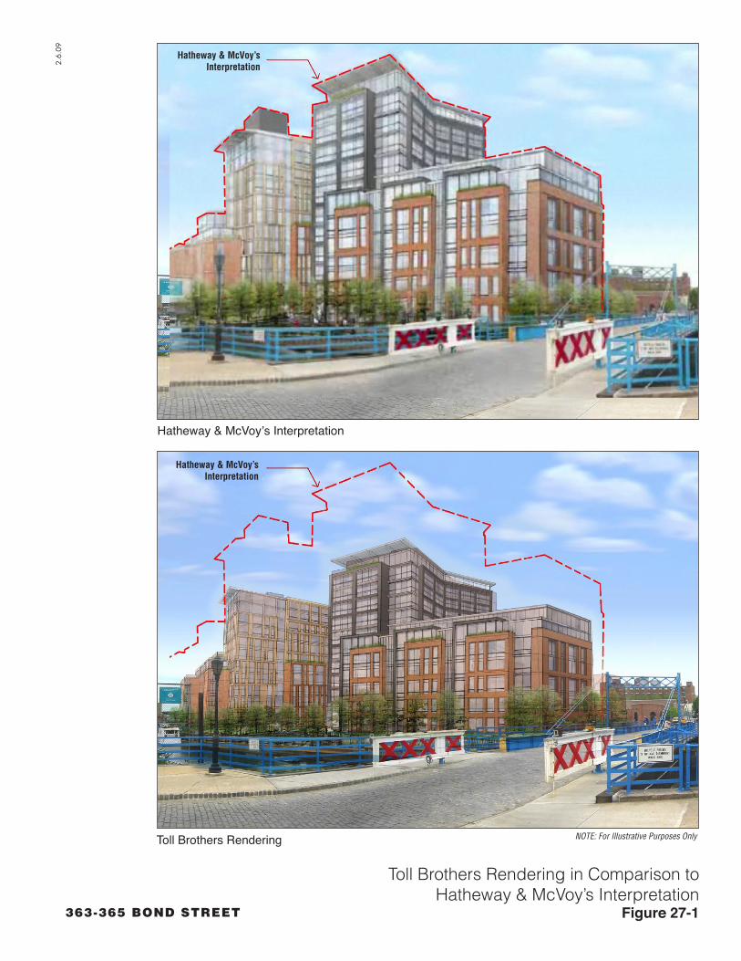
Comment 1-2: The rendering from across the canal (Figure 1-11c) inserts the project into the existing photo at a significantly smaller size than it would appear in reality. Measured against the existing buildings in the view, the 12-story portions scale to be approximately 85 feet high instead of the proposed 124 feet and 8 inches and they are shown narrower than they would appear in this view. The rendering also omits the elevator bulkhead which scales to be approximately 145 feet in the section provided in the DEIS. (Hatheway/McVoy)
Response 1-2: Figure 1-11c in the DEIS was included for illustrative purposes, and reflects an artist’s interpretation of the proposed buildings. The rendering showed general building design, massing, and project layout. The methodology used to develop the commenters’ rendering is unclear (see FEIS Appendix I for the submitted written comments on the DEIS). To address the comment, Figure 1-11c has been further refined in the FEIS based on current survey and topographical data. The revised image also accounts for the setback from the water’s edge and the 125 foot height limitation. The revised rendering is not significantly different from that which appeared in the DEIS. The DEIS also included measured drawings and accurately scaled site plans showing the heights, including the elevator bulkhead (see Figures 1-5 through 1-10) Based on all these data, it was the conclusion of the DEIS, and remains the conclusion of this FEIS, that the proposed project would not have any adverse impacts with respect to urban design and visual resources.
An additional figure is included to the Response to Comments chapter (see Figure 27-1), which illustrates the inaccuracies of the massing presented by the commenter during the public review process as compared to the massing actually proposed by the applicant. The conclusion of Chapter 8, “Urban Design and Visual Resources,” of the DEIS with respect to urban design and visual resources remains unchanged (i.e, no adverse significant impacts from the proposed project).
Comment 1-3: Neither of the canal side renderings (Figure 1-11a and 1-11b) includes the 12 story portions of the project, giving the false impression that the project is 6 stories along the canal. (Hatheway/McVoy)
Response 1-3: The DEIS contained multiple illustrations and dimensioned drawings (see Figures 1-5, 1-6, 1-8, 1-11c, and 8-17) showing the heights of buildings proposed at the project site. For example, as shown on Figure
27-10
2.6.
09
363-365 BOND STREET
Toll Brothers Rendering in Comparison toHatheway & McVoy’s Interpretation
Figure 27-1
Hatheway & McVoy’sInterpretation
Hatheway & McVoy’sInterpretation
NOTE: For Illustrative Purposes Only
Hatheway & McVoy’s Interpretation
Toll Brothers Rendering

Chapter 27: Response to Comments
1-6 of the DEIS, the buildings along the canal are comprised of 5, 6, 7, 11, and 12 story elements. As stated in the DEIS, only about 9 percent of the footprint of the project site would be occupied by 12-story building elements. Figures 1-11a and 1-11b which are presented in Chapter 1, “Project Description,” were provided for illustrative purposes, and were intended primarily to illustrate the views from the publicly accessible open space along the canal and of canal itself. Therefore, the 12 story building elements would not be visible from these locations. However, these views do accurately depict the base of the buildings that would be visible from these vantage points.
Comment 1-4: In this context, the height of the buildings is appropriate. The project site is situated in a geographically lower area and the heights will blend into the surrounding. If the buildings were lower, they would be bulkier and would not be in context. Since Public Place was approved nearby with 12 stories, Toll Brothers should not be treated differently. (Spicer)
The height of the proposed buildings is not a problem. It’s scaled down to meet, to a great degree, the Carroll Gardens community. (Scotto)
Response 1-4: Comment Noted.
Comment 1-5: The open space along the canal would be enhanced if some portion of the development fronting the canal was occupied by commercial use. This does not mean that the developer would have to give up more valuable residential development. The retail proposed along First Street could be switched to a canal frontage location. In this way, the commercial space becomes more of a community amenity. Even with subsequent redevelopment on the east bank of the canal per the DCP Framework for the Gowanus Canal, the publicly accessible space that Toll would construct would benefit from sunlight from the mid-morning until the early afternoon. Such space would be enhanced as a community congregation area by having an opportunity to obtain beverages and food adjacent to the canal. Though convenience food in itself might be challenging to operate successfully as a business from the sales generated from building residents and open space congregants from the neighborhood, joint use as gallery/artisan (wares such as handmade jewelry, etc.) space could help sustain such a commercial space, while being in synergy with the many galleries that are already integrated within Gowanus. Therefore, space for such uses should be included along the canal. (Borough President)
The developer should include more retail that canoeists could access after utilizing the Canal. (Foote)
27-11

363-365 Bond Street FEIS
Response 1-5: As stated in Chapter 1, “Project Description,” of the DEIS, the proposed project provides on 1st Street approximately 2,000 square feet of commercial space approximately only 50 feet from the waterfront publicly accessible open space. 1st Street is centrally located within the project site including the length of waterfront along the open space. Thus, the proposed commercial space would be easily accessible to pedestrians both on the street and on the waterfront open space and would serve the functions identified in the comment. The applicant finds that the current location is more economically viable, would draw greater patronage, and would provide a proper balance between accessibility to the community and open space users than would one located on the open space itself. The applicant believes that the amount of commercial space and its location are appropriately sized to serve the needs of the project and the immediate community.
Comment 1-6: The city should avoid this type of spot zoning. The proposed project should be part of the larger Gowanus Canal rezoning and the consideration of the Carroll Gardens contextual rezoning. (Hammerman, Defend Gowanus, McClure, Buxbaum, McTernan, Hagan)
I have strong reservations regarding the proposed spot re-zoning of the two blocks upon which subject proposed development is to take place. I do not think that these two blocks should be carved out of the greater Gowanus Canal rezoning plan. (Hatheway)
I am writing as a former resident of Gowanus who cares deeply about the area. While City Planning has said they would approach planning for the neighborhood as a whole, the Toll Brothers project is a spot rezoning, in fact, that flouts larger environmental and planning issues. (Braun)
Response 1-6: Spot zoning is defined as a rezoning that encompasses a small site and is inconsistent with general land use plans and adjacent zoning districts and uses. The proposed zoning actions are not spot zoning. The action covers a two-block area proposed to be mapped as a mixed-use district that reflects the surrounding built character of the neighborhood, including the residential zoning districts that are mapped immediately to the west of Bond Street. In addition, the proposed action is consistent with the City’s plans and policies, including but not limited to, the Framework for the Gowanus Canal and PlaNYC (see Chapter 2, “Land Use, Zoning, and Public Policy”).
This proposal has been subjected to the requisite review under CEQR/SEQRA as well as ULURP. It addresses the City’s Framework for the Gowanus Canal as well as all relevant plans and policy
27-12

Chapter 27: Response to Comments
statements. Thus, it is concluded that the rezoning and environmental review process have not been circumvented. See also response to Comment 1-7.
Comment 1-7: This project, seeking a rezoning green light ahead of the much larger Gowanus rezoning, presented varied, legitimate concerns to it potential neighbors. Allowing this project to move ahead of the overall rezoning always seemed premature, and inherently, unfair. This project should be incorporated into the larger Gowanus pciture and reassessed within that context. (Miller)
Allowing this project would circumvent the rezoning process and would allow developers to determine how the land looks and feels. The Gowanus Plan should apply to all development along the Canal. It shows that a great deal of thought and community input went into it, including lessons learned on the Park Slope/4th Avenue rezoning. Our concerns over the Toll Brothers application is that we are circumventing the master rezoning process and allowing a developer to take the lead on how the Gowanus will look and work. (Kelly)
When this project is looked at as one component of the larger rezoning, does permitting the altering of the lay of the land to accommodate this one development really seem like the wisest, most responsible use of this particular piece of property? (Miller)
This application is premature, especially given the City’s desire to take a more comprehensive look at the zoning in the Gowanus area, which is needed (in part) to provide a more extensive environmental impact statement that would better reflect, analyze and propose mitigation for the cumulative impacts of development in our community; consideration of this application now, before the City’s actions, was compared to putting the cart before the horse. The Department of City Planning should move forward expeditiously with the broader Gowanus Canal area rezoning, to provide a consistent regulatory framework so that proposed development is not one isolated outpost, and so that we do not continue to receive spot zoning requests. DCP should alsomove forward expeditiously with the contextual rezoning/downzoning of Carroll Gardens, so that out-of-scale development does not continue to take place in Carroll Gardens, just a few steps away from this subject proposal. (CB6)
The community is concerned that this project is moving forward ahead of the Gowanus rezoning and the contextual rezoning of Carroll Gardens. (Council Member de Blasio)
27-13

363-365 Bond Street FEIS
The review of the proposed project must serve as the review of the Framework because the proposed project will set a precedent for the Framework (Hatheway/McVoy)
The Gowanus Canal is a unique resource. The Department of City Planning should view the Gowanus Canal area as a whole and as a blank slate. They should not allow spot zoning. (Skollar)
I hope that the City understands that approval of the Toll Brothers project in its current state sets a precedent for development in the Gowanus area that seems premature and, frankly, irresponsible, considering that rezoning for the whole area is currently under study and that such viable, creative and constructive alternatives to this particular development are being offered. (O’Neill)
I have serious objections to the Toll Brothers spot rezoning request for the Gowanus Canal area. First of all, I feel this request is totally unfair and sets a dangerous precedent for an area that will be a challenge to develop due to many serious issues. The Toll Brothers project needs to be part of an extensive and better considered plans to rezone the Gowanus as a whole. (Samaras)
Response 1-7: The design of the proposed project reflects over four years of site analysis and urban design, informed by iterative discussions with DCP staff and the community, during which the plans were substantially refined. The proposed action is also consistent with the City’s Framework from the Gowanus Canal and is a specific zoning proposal with independent utility that is proceeding in advance of any potential future area-wide rezoning of the Gowanus Canal corridor or rezoning/downzoning of Carroll Gardens. It is also consistent with environmental and land use requirements. In addition, the lead agency has determined that, pursuant to NYCRR Section 617.3(g)(1), to the extent that an area-wide rezoning proposal for the Gowanus Canal corridor is proposed for consideration by the City Planning Commission during the same timeframe as the consideration of the proposed action, environmental review of the proposed action does not present issues of impermissible segmentation under environmental review. See the revised Positive Declaration dated August 29, 2008.
With respect to the DEIS impact analyses, the CEQR process ensures that a full and comprehensive analysis of the applicant’s proposal with respect to impacts on schools, infrastructure, the subway and urban design as well as other impact categories is performed. CEQR also ensures that mitigation is identified for any significant adverse impacts caused by the applicant’s proposal. The comment is also incorrect with respect to precedent. The proposed project is independent of and would
27-14

Chapter 27: Response to Comments
not dictate or establish any precedent for any other rezoning of the Gowanus Canal area.
Lastly, as discussed in Chapter 2, “Land Use, Zoning, and Public Policy,” the proposed actions would be consistent with the goals outlined by DCP for the larger Framework for the Gowanus Canal.
Comment 1-8: While some argue that this project should be delayed until the formal rezoning is completed, I disagree and so did the majority of our Community Board. We felt that it was a solid, well developed addition to the neighborhood and should proceed as a model of what good development can look like. This project falls within the rezoning framework developed by DCP. (Spicer)
The local community has exhibited a broad support for this project as expressed by a 2 to 1 vote in favor of the project at Community Board 6. This consensus was arrived at through the persistence of the Chairperson Burden, the tireless efforts of the Brooklyn office of City Planning and many local groups and individuals in creating a framework for the rezoning of the Gowanus area. In addition to such community board support we had obtained, in a matter of a weekend, over sixty letters of support, primarily form area businesses both retail and “manufacturing,” in favor of the Gowanus rezoning. (Shames)
Response 1-8: Comment Noted.
Comment 1-9: The amount of affordable housing for this project should be at least 30 percent of the total residential units constructed. (CB6)
Response 1-9: As stated in the DEIS under Chapter 1, “Project Description,” under the proposed Special Mixed-Use District, the rezoning area would have a maximum floor area ratio (FAR) of 3.6 (with the provision of inclusion of 20 percent of the residential floor area as affordable housing for low-income households). This would allow a development program on the project site that would contain approximately 447 dwelling units, of which approximately 130 would be affordable. This constitutes approximately 30 percent.
Comment 1-10: The achievement of affordable housing must be enhanced by sequencing construction so that development on the south side of First Street—containing approximately two-thirds of the proposed affordable housing component—be chosen by Toll to be the beneficiary of up to three application cycles for State funding assistance based on the written commitment dated December 17, 2008 that supplements the
27-15

363-365 Bond Street FEIS
December 15 commitment; and, that the affordable housing on both blocks also includes three-bedroom units. (Borough President)
Response 1-10: While the sequencing of affordable housing is outside the scope of the CEQR review, it is the applicant’s commitment, subject to the availability of necessary public funding on terms comparable to those available today, to provide the approximately 130 low income units that have been consistenly described as an integral part of this project. An application for the 2009 round of public funding is being prepared, and if not approved, will be resubmitted in 2010, which is within the project’s build year (2011). It should be noted that a primary objective of the applicant was to maximize the number of affordable housing units provided to the community. To that end, smaller, rather than larger, units maximize the overall number of units within a given allocation of floor area. The project architect has not yet designed the layout and floor plans of all of the affordable units and the applicant will consider the feasibility of the inclusion of three-bedroom units on each block at the time that the design and layout of the affordable units is finalized.
Comment 1-11: This project will bring much needed affordable housing to Brooklyn and while also adding an aesthetically pleasing element to the area and public open space. Toll Brothers included more affordable housing beyond the inclusionary zoning requirement. (Spicer)
Response 1-11: Comment Noted.
Comment 1-12: This project will put housing in an area that is completely desolate. (Pugliese)
Response 1-12: Comment Noted. The proposed project would redevelop underutilized waterfront properties along the Gowanus Canal and would create new housing, including affordable housing, and knit together the existing residential fabric in the neighborhoods of Gowanus, Park Slope, and Carroll Gardens.
CHAPTER 2: LAND USE
Comment 2-1: Why is it that R8—12 story buildings will be considered acceptable in the proposed zoning changes right next to the Canal, at the bottom of the Gowanus “watershed” when only 6 blocks away at the top of the Gowanus “watershed,” Union and Court, R6, only 6-story buildings would have been permitted? Where housing density could accommodate greater density, you forbid it; where we should be seeking lower density, you seem to encourage higher density. (Buxbaum)
27-16

Chapter 27: Response to Comments
Response 2-1: The comment contains misinformation. As stated in the DEIS, the proposed rezoning is to map a new R7-2/C2-4 MX district, not an R8 district at the project site. The R6 district at Union and Court Streets within Carroll Gardens (approximately 2,000 feet west of the project site) is a long established district for a substantially developed area and reflects the existing built context. As discussed in Chapter 2, “Land Use, Zoning, and Public Policy,” DCP’s Framework for the Gowanus Canal contemplates 8-12 story buildings on limited portions of large blocks specific locations abutting the Gowanus Canal. The City’s Framework for the Gowanus Canal establishes limits for height and density that consider neighborhood context, while (1) allowing for a mix of uses, including residential, in certain areas currently zoned for manufacturing uses, (2) maintaining areas for continued industrial as well as commercial uses, (3) creating opportunities for public access at the canal's edge, (4) enlivening the streetscape with pedestrian-friendly, active ground-floor uses, and (5) promoting affordable housing in keeping with the City's Inclusionary Housing Program. The City determined that the most appropriate locations for these taller building elements is closer to the Canal on large blocks. These locations ere further away from established low-rise residential neighborhoods, such as that at Court and Union Streets. Thus, the Framework and proposed project reflect a balance between the foregoing objectives.
Comment 2-2: The renderings in the DEIS do not show future development that would likely occur at the scale permitted by the City’s proposed rezoning. The proposed project should be represented in the context of the buildout of the City’s proposed rezoning. (Hatheway/McVoy)
Response 2-2: The renderings in the DEIS properly show the proposed project in the project’s build year, which is 2011. The details of the City’s potential areawide rezoning have not yet been finalized as it is just starting its environmental review process. It is anticipated that the build year for that rezoning action would be 2018, which is well beyond the build year (2011) of the proposed project. Given the absence of a proposed plan and the later build year, an analysis of that rezoning proposal is not required under CEQR/SEQRA for this project’s EIS.
CHAPTER 3: SOCIOECONOMIC CONDITIONS
Comment 3-1: The canal area should always include light manufacturing and spaces for the many artists like myself. Many other musicians have practiced and recorded in the Gowanus Canal area which means that a separate culture already exists in this area and it would be a big mistake to displace that culture. This culture includes many other art forms such as
27-17

363-365 Bond Street FEIS
visual arts and theater. If you eradicate these cultural aspects of the Gowanus Canal area, there will be fewer and fewer “real” (neighborhood) people living in Brooklyn. What is the rationale to displace all of these people as well as valuable light manufacturing which also provides additional jobs and local dollars?
Let’s please make it possible for Gowanus musicians and other artists to continue working/living where they are as they provide valuable income for NYC! The arts provide the cultural capital for NYC! (Veuve)
Response 3-1: As set forth in Chapter 2, “Land Use, Zoning, and Public Policy,” there is no proposal to eradicate light manufacturing space along the Gowanus Canal. The proposed project would directly displace from the project site two existing businesses (a warehouse and a trucking business) that employ a minimal number of employees in non-cultural related businesses, and this would not result in any adverse socioeconomic or neighborhood character impacts. Although not the subject of this EIS, the proposed Framework for the Gowanus Canal and a potential city-sponsored rezoning, thereunder, would maintain light industrial zones in the Gowanus area. As described in Chapter 1, “Project Description,” the proposed project would not displace any low-cost residential units, but would include approximately 130 affordable units. Thus, the proposed project would expand housing opportunities for the persons described by the commenter. In addition to the foregoing, Chapter 3, “Socioeconomic Conditions,” identifies that the study area currently has a residential population whose median household income is more than 53 percent higher than in all of Brooklyn. The DEIS further establishes that residents of the proposed project are not expected to have different socioeconomic characteristics compared to the existing population of the study area. Therefore, the proposed project would not significantly affect socioeconomic trends within the study area and would not adversely impact the ability of local artists to contribute to the local arts economy of New York City.
Comment 3-2: If you displace all these cultural types, where will they go? My ensemble and I will have to consider NJ as the next likeliest, next affordable place with easy access to Manhattan via the Path train. So overbuilding the Gowanus Canal area with "luxury condos" will inadvertently funnel valuable arts dollars to Newark and other more affordable areas in New Jersey giving away the arts edge NYC has always maintained to another state! The loss of these valuable arts culture dollars would be a big mistake for NYC. (Veuve)
27-18
Chapter 27: Response to Comments
Response 3-2: As explained in the response to Comment 3-1, the proposed project would not cause any direct or indirect residential displacement because the project site is not currently zoned for residential use and the proposed project would provide housing that is comparable to the values of existing housing in the study area. Moreover, the proposed project would provide affordable housing units that do not currently exist at the project site. In light of the fact that there would be comparable market-rate housing, affordable housing, and the maintenance of industrial zoning within the study area, the commenter is speculating that Brooklynites would relocate to New Jersey.
Comment 3-3: Shouldn't we protect industries other than the financial sector to keep ourselves financially diversified? Do we really need to lose our culture and light manufacturing industry in order to turn Brooklyn into a bedroom community for Manhattan? Fourth Ave has already been up-zoned for high rise housing. Why should the Gowanus area copy that? The Canal's culture is unique and should be preserved. (Veuve)
Response 3-3: As explained in Chapter 2, “Land Use, Zoning, and Public Policy,” industrial activities in the Gowanus area have declined steadily over the last 50 years. As a result of this decline, some industrial zoned properties along the Canal area are currently vacant or underutilized. The rezoning for the proposed project site is consistent with the effort under the Framework for the Gowanus Canal that seeks to balance the objectives of maintaining viable industrial uses, encouraging affordable housing, revitalizing underutilized land with mixed-use development, and providing new waterfront public access.
The proposed action is not similar to the 4th Avenue rezoning. The residential FAR at the project site would be 2.7 (3.6 with the provision of affordable housing). Unlike the proposed actions, the residential density on 4th Avenue in the R8A zones is 6.02 FAR. Thus, the 4th Avenue rezoning is of a substantially greater density than what is proposed at the project site.
Comment 3-4: How much more housing do we really need? I see plenty of high rise housing already being built all the Downtown Brooklyn area recently. Yet, the projected figures for the supposed population growth of NYC by the year 2030 have now been re-calculated and downsized. Do we really need to make Brooklyn a weekday bedroom of Manhattan? More and more people will simply purchase a condo for easy access to Wall Street jobs, but sleep in their “real” homes in Connecticut or Long
27-19

363-365 Bond Street FEIS
Island or New Jersey on the weekends! Brooklyn should never be Manhattan’s bedroom. (Veuve)
Response 3-4: As explained in Chapter 2, “Land Use, Zoning, and Public Policy,” regardless of short-term economic variations, housing demand is projected to increase in New York City. In response to this increase in demand, the City has adopted a policy to promote the creation of 265,000 new units of housing throughout the city. The proposed project would provide market-rate and affordable housing, which would be consistent with this policy. It is purely speculative whether the proposed project will cause Brooklyn to become a bedroom community of Manhattan, whether the proposed project will cater to Wall Street employees, or whether purchasers will have their “real” homes in any of the aforementioned locations.
CHAPTER 4: COMMUNITY FACILITIES
Comment 4-1: We need to make sure that the community facilities will be able to handle the new development occurring in the surrounding area. The analyses of fire and safety also need to be tied together in a coherent fashion. (Council Member de Blasio)
Response 4-1: The DEIS considered the potential impacts on community facilities through the 2011 analysis year, taking into account other projects proposed by the year 2011 in the same catchment area. These analyses are presented in Chapter 4, “Community Facilities.”
Subsequent to the publication of the DEIS, DCP released (in November 2008) updated generation rates for the projection of children from a proposed project who would be eligible for publicly funded day care facilities. Additionally, the New York City Department of Education (DOE) released updated public school student generation rates for the projection of school children, in conjunction with the release of its new five-year (2010-2014) capital plan based on this information. Because of these updates, the analysis of public schools has been updated for this FEIS to reflect these new rates and an analysis of day care facilities has been added to Chapter 4, “Community Facilities”. Based on the methodologies presented in the CEQR Technical Manual, the analyses concluded that the proposed project would not result in any significant adverse impacts with respect to community facilities, including schools, day care facilites, libraries, health care facilities and police and fire services.
Comment 4-2: The borough president is aware that the baseline analysis used to determine school populations was subsequently made obsolete after the
27-20

Chapter 27: Response to Comments
DEIS was circulated at the outset of the public review process. Prior to preparing the final EIS, the borough president recommends that Toll consult with the following website http://insideschools.org or the Department of Education’s (DOE) Enrollment, Capacity and Utilization Report to evaluate school occupancy. The Toll site is within the enrollment catchment area of P.S. 32. Using the latest data, it is possible that this project would reach the maximum capacity in the building for the elementary school. At a meeting between the Borough President’s Office and DOE held on November 20, 2008, it was noted that P.S. 133 would be split between District 13 (300 seats) and District 15 (600 seats). In addition, the building housing P.S. 32 also contains a middle school and a District 75 school. Therefore, the DOE appears to have multiple options to address capacity at P.S. 32 prior to significant occupancy of what would be developed by Toll or other entities. (Borough President)
Response 4-2: This concern has been addressed in the FEIS, see response to Comment 4-1 above.
CHAPTER 5: OPEN SPACE
Comment 5-1: I want to compliment this project on the plans for open public space. To say this will be a major improvement in the area is a severe understatement. (Spicer)
Response 5-1: Comment Noted.
Comment 5-2: We believe that twelve story buildings lining the Gowanus Canal here would seriously compromise the quality of the relatively narrow waterfront publically accessible park. The DEIS provides insufficient information to assess the impact of the project’s bulk on the open space along the canal. (Hatheway)
Response 5-2: The proposed project’s open space would not be lined with 12-story buildings (only approximately 9 percent of the project site contains 12-story elements), nor would the quality of the proposed open space be compromised by the inclusion of two 12-story building elements. As stated above, these elements constitute approximately 9 percent of the project site footprint and abut only approximately 60 linear feet of the length of the proposed waterfront open space. Moreover, the proposed two 12-story building elements are setback approximately 60 to 70 feet from the water’s edge.
As stated in the DEIS in Chapter 8, “Urban Design and Visual Resources,” the taller building elements located on the eastern portion of the project site would be wrapped by six-story bases in order to
27-21

363-365 Bond Street FEIS
minimize the perceived height of the development as viewed from the eastern portions of Carroll, First, and Second Streets, and from the waterfront esplanade. The buildings would be set back at least 40 feet from the canal at the base. Approximately 30,821 square feet of the proposed project open space (including landscaped street ends) would create a visual corridor along the canal, providing extensive public views to the east, north and south.
The EIS concluded that the bulk of the proposed project would not adversely impact the project’s open space. In Chapter 6, “Shadows,” it was determined that there are no off-site publicly-accessible open spaces that could be affected by the proposed buildings’ shadows. The only publicly-accessible open space that would be affected by project shadows at varying times on all four of the analysis days would be on the project’s proposed waterfront open space. However, while shadows would be cast on the proposed project’s publicly-accessible open space, shadows cast on open spaces that are part of a proposed project or action are not considered impacts of an action because without the proposed action, the open space would not exist.
In light of there being no specific project plan that would line the Canal with 12-story buildings, it would be speculative to include such an analysis in the EIS.
CHAPTER 6: SHADOWS
Comment 6-1: 12-story buildings limit the amount of sun on the park to 2.5 hours on the equinoxes. The 8-story buildings proposed in the alternative plan would increase the amount of sunlight to 4 hours per day. (McVoy)
According to Toll Brothers’ own submission, the shadow created from the tower will darken the publicly accessible canal-front park from the late afternoon onwards. At the very time when most people get out of work to stroll along the park, it will be like walking in darkness! Toll says it can’t be responsible for this because without the development, there would be no publicly accessible canal-front! But let’s do development the right way-if we’re going to set forth a Gowanus plan that values an accessible canal front, at least let’s not ruin it with the first building going up. (Cohen)
Response 6-1: The commenter’s calculations are incorrect. As determined by the DEIS’s shadow’s analysis, the proposed project’s open space would be in direct sunlight most of the day on the equinoxes. Furthermore, increasing the height of the buildings from the project’s mix of 4, 5, 6, 7, 11, and 12-story building elements to a uniform 8 stories would serve to increase shadows on the proposed project’s open space.
27-22

Chapter 27: Response to Comments
As discussed in Chapter 6, “Shadows,” on the December 21 and March 21/September 21 analysis days, areas of the northern section of the proposed waterfront open space between Carroll Street and 1st Street would be affected by incremental shadows in the late afternoon. On the May 6 and June 21 analysis days, incremental shadows would fall on portions of both the northern and southern sections of the waterfront open space throughout the second half of the day. However, under CEQR, while shadows would be cast on the proposed project’s publicly-accessible open space, these shadows are not considered impacts of an action because as stated above without the proposed action, project open space would not exist. In light of there being no specific project plan that would line the Canal with 12-story buildings, it would be speculative to include such an analysis in the EIS.
Comment 6-2: It is unclear whether the modest green space along the canal would survive without sufficient sunlight in the project’s current configuration. (van den Bout)
Response 6-2: As described in Chapter 10, “Natural Resources,” the construction of the proposed project would create approximately 0.7 acres of waterfront open space that would be planted with a variety of native and ornamental trees, shrubs, grasses, and herbaceous perennials. Only plants that will survive in the conditions present will be planted. The New York City Department of Parks and Recreation (DPR) has approved the proposed plant species to ensure that all street tree and publicly-accessible open space tree species planted on-site are appropriate for the amount of sunlight the proposed open space would receive.
Comment 6-3: The DEIS does not provide shadow studies that show the cumulative impact of the 12 story portions on other blocks that would surely be built if the proposed Toll Brothers project is approved (Hatheway/McVoy)
Response 6-3: As stated above, the DEIS was not required to include such studies because the proposed actions would not result in development on properties other than the project site. There is no basis to assert that additional 12 story buildings will be built on other blocks if the proposed project is approved. If and when additional 12 story buildings are proposed or would result from another zoning proposal, they will be subject to their own land use and environmental review.
27-23

363-365 Bond Street FEIS
Comment 6-4: It is unclear what the effects of significant shading from the proposed project would be on the ecosystem of a newly restored Gowanus Canal. (van den Bout, Iskiw)
Tall buildings would block sunlight from reaching the canal except for a few short hours each day and this would be to the detriment of the water quality and landscape plantings. (Marchese)
Response 6-4: As described in Chapter 6 of the DEIS, “Shadows,” because of the current condition of the waters of the Gowanus Canal (i.e., limited opacity, and poor benthic community structure), the canal is not considered a natural feature that is significantly sensitive to sunlight intensity. Nevertheless, the Gowanus Canal would experience direct sunlight for most of the day in all seasons (see Table 6-1). Many of the species using the waterway are tolerant of highly variable sunlight conditions. A late-afternoon shadow progressing across a narrow portion of the canal over a period of less than four hours would not significantly affect the aquatic resources associated with the canal. Therefore, the DEIS concluded that the proposed project would not result in a significant adverse shadow impact.
CHAPTER 7: HISTORIC RESOURCES
Comment 7-1: The 12-story tower on the northern block as proposed by the developers, and permissible under this plan, is the more massive of the two towers in this development and would be directly on axis with Carroll Street, between Smith and Hoyt Streets, one of two blocks in the Carroll Gardens Historic District. This tower would completely alter historic views within the Carroll Gardens Historic District. The Toll Brothers proposal would substantially alter the historic views of the historic district and tower over the small-scale Hoyt Street houses thus compromising the quality of the historic district. The DEIS provides insufficient information to assess the impact of the project’s bulk on the Carroll Gardens Historic Core. (Hatheway)
Carroll Gardens is noted for its small-scale row houses and, on certain blocks, its wide front yards, creating very open, airy streets. The buildings in the area from Bond Street up to Smith Street are generally 2- to 3-story houses, with the tallest being 3-stories over a habitable basement. This scale means that views of buildings beyond the block on which one resides are very limited. This would give a unique openness and intimacy to the neighborhood, which the proposed rezoning and Toll development ignores. (Hatheway)
Response 7-1: The DEIS had sufficient information to properly conclude that there would be no significant adverse impacts on the Carroll Gardens Historic
27-24

Chapter 27: Response to Comments
district.The extensive analysis done for the DEIS was based on field visits, building inventories, survey data, photo inventories, literature searches, and multiple renderings, plans, drawings, to assess the bulk of the proposed project on the surrounding historic resources and neighborhoods including the Carroll Gardens Historic District.
As described in Chapter 7, “Historic Resources, views to the project site from the Carroll Gardens Historic District are extremely limited due to the relatively long distance to the project site, the presence of intervening buildings and trees, and the topography, which slopes downwards fairly steeply between the Carroll Gardens Historic District and the project site. Furthermore, the project buildings have been designed with low-rise elements in the western portion of the project site (the portion closest to the Carroll Gardens Historic District) and the medium-rise elements further east, in order to further minimize any views of the project buildings that may be available from the Carroll Gardens Historic District. Therefore, the proposed project would not substantially alter the context or visual character of the Carroll Gardens Historic District and would have no adverse impact on this resource. In response to the comment, the applicant has created a scaled graphic based on a photograph provided by the commenter, illustrating the appropriate massing of the proposed buildings (see Figure 27-2). This figure confirms that the views of the proposed project from the Carrol Gardens Historic District are limited to a portion of the upper three stories and the elevator bulkhead. These views would be further obscured by the presence of foliage. The mere view of a portion of the top three stories and elevator bulkhead of the proposed buildings will not change the adjacent brownstone fabric or any of the characteristics that resulted in the creation of the Carroll Gardens Historic District.
Comment 7-2: We support many of the goals of the rezoning and the Toll Brothers proposal, including residential use, canal-front publicly accessible green space, affordable housing, and a density of FAR 3.6. However, our intimate knowledge of the area leads us to conclude the City’s proposal for the “MX Waterfront South” is flawed. We do not accept the proposal’s premise that these blocks, especially the short ones on the canal’s western side, can transition from the 2- to 3-story adjacent brownstone fabric to twelve stories at the canal without significantly compromising the urban quality of adjacent historic fabric. (Hatheway, Hatheway/McVoy)
The 400-foot depth of this site is not enough to lessen the impact of a transition from 2- and 3-story buildings to 12-story buildings. (McVoy)
27-25

View Down Carroll Street from Smith StreetFigure 27-2
2.5.
09
363-365 BOND STREET
Proposed
Proposed with Hatheway & McVoy’s Interpretation
Hatheway & McVoy’sInterpretationHatheway & McVoy’sInterpretation
Toll BrothersRenderingToll BrothersRendering
NOTE: For Illustrative Purposes Only
NOTE: For Illustrative Purposes Only

363-365 Bond Street FEIS
Response 7-2: The City’s future planned rezoning proposal for the Gowanus area is outside the scope of this application. As discussed in Chapter 2, “Land Use, Zoning, and Public Policy” the City’s draft rezoning proposal is expected to be refined with on-going community input and may be put forth formally in a Draft Scope of Work for the purposes of preparing an EIS in February 2009. However, the proposed project has been determined to be consistent with the land uses and building heights that would be allowed per the Framework for the Gowanus Canal (see Chapter 2, “Land Use, Zoning, and Public Policy”). In addition, the proposed project was reviewed by SHPO and LPC and it was determined that the proposed project would have the context or visual character of the Carroll Gardens Historic District, and would have no adverse impact on the resource (see Chapter 7, “Historic Resources).
Comment 7-3: The Gowanus Canal is a National Treasure. Stop the politicization of an important landmark. It can be made into a beautiful waterway. (Shifreen)
The Gowanus Canal is eligible for the National Trust for Historic Places; so why would the city allow big housing development on its edge? (Marriano)
Response 7-3: Chapter 7, “Historic Resources,” of the DEIS contains a comprehensive analysis of all historic resources located both on the project site and within an expansive study area. The applicant worked closely with the New York City Landmarks Preservation Commission and the New York State Historic Preservation Office (SHPO) in connection with the materials presented in the DEIS (see Appendix A). In the SHPO letter dated August 7, 2008, SHPO determined that the proposed project would have “no adverse effect upon historic resources” provided certain conditions were met, which the applicant will comply with (see Appendix A).
CHAPTER 8: URBAN DESIGN AND VISUAL RESOURCES
Comment 8-1: The height and massing of this project is inappropriate for this site, as it would be atypical and dominate the local landscape. (CB6, Heller)
This proposal is clearly out of scale with the surrounding context and honors neither its historic residential nor its industrial past. (van den Bout)
Twelve, eleven, and nine-story development is way out of scale anywhere in the project’s area. The openness of the area is part of the inherent beauty that creates a strong sense of community. (Young)
27-26

Chapter 27: Response to Comments
Twelve stories is much too high for our low-rise neighborhood. These buildings will dwarf our small two- and three- story homes. Nearby 4th Avenue, just one block west of the canal, has been rezoned for 12-story developments, many of which are completed or already in progress. Why not allow 4th Avenue to continue to grow and develop and restrict the low area of the canal to 80 feet at most? (DeCarlo)
The project should be limited to 8 stories. (Schrank)
Any new construction should be limited to 5 stories. This is a wonderful low-scale neighborhood, but many recent developments have already begun to change the character of the area, and it is my hope that this can be prevented in the future. (Rupolo)
We implore you to restrict the height of the Toll Bros project and do all you can to save this unique and wonderful area from any change that will not truly boost the economy, the aesthetics, or the spirit of the area. (Lamazor)
The Gowanus Canal neighborhood needs a comprehensive, environmentally sound development plan that conforms to the scale of the neighborhhod surrounding the canal. 8- to 12-story apartment buildings are exploitative, and not a necessary element of a successful and respectful residential development. (Congdon)
The Toll Bros. project needs to be scaled back and the Canal and its surround neighborhood need to be preserved and protected. (Dillon Sedia)
Response 8-1: As analyzed in Chapter 8, “Urban Design and Visual Resources,” the DEIS analysis evaluated the height and form of the proposed project and concluded that the project would not result in any significant adverse impacts with respect to urban design and visual resources. The proposed project has been designed and sited so as to minimize its visual impact on the surrounding community. The lower five-story (and penthouse) segments are placed on Bond Street, reflecting the lower-scale context of the neighborhood area to the west, as well as the narrow mapped width of Bond Street. The taller project elements (heights of 7, 8, 11, and 12 stories) have been located deeper within the project site (to the east) and are wrapped by lower-rise elements that have been further facetted and broken down so as to reduce their perceived bulk to create variations in building heights within the project blocks.
The proposed project would include limited elements that are comparable or lower in height than buildings that exist in the study areas, including the Former Brooklyn Rapid Transit Power House (9 stories), Gowanus Houses (14 stories) and Wyckoff Gardens (21 stories). Furthermore, the height of the various elements of the proposed
27-27

363-365 Bond Street FEIS
project has been distributed to maintain the low-rise character of the Bond Street frontage and the mid-block portions of Carroll, First, and Second Streets. As described in the DEIS, the Bond Street frontage of the proposed project has been designed with a consistent street wall, set back 5 feet from the sidewalk by a small planting area, all to create a pedestrian streetscape environment in keeping with the existing character of the area. The low-rise townhouse elements planned for the mid-block portions of 1st and 2nd Streets have been designed to reference the rowhouses typical of the surrounding residential neighborhoods. Each four-story townhouse element would contain an individual stoop-like entrance to the street. The footprint of the proposed building complex would be consistent with many older industrial buildings located along the canal in the study areas. The proposed project would not change the shapes of the project blocks. For all these reasons, in conjunction with the provision of the proposed approximately 0.7 acres of landscaped open space that would be created, the proposed project reflects a reasonable balance between existing and proposed building heights, and bulk and new open space.
In addition, in a letter dated August 7, 2008, the New York State Historic Preservation Office (SHPO) stated that the proposed project would have no adverse effect on architectural resources including the S/NR-eligible Gowanus Canal Historic District.
Comment 8-2: It is important to note that the architect’s rendering presented at Community Board hearings and Borough President Markowitz’s hearing contained an inaccurate massing of the St. Mary Star of the Sea Residence, showing the entire building rising to the height of its rooftop bulkhead. This inaccuracy made the proposed towers appear more obscured and minimized their impact. (Hatheway)
Response 8-2: Based on the comment, a graphic has been prepared and added to the FEIS (see Figure 8-17), which depicts the existing conditions and the proposed project’s massing from a view down Carroll Street at Smith Street. This figure is based on the current topographic data and the scale and location of the existing (including St. Mary Star of the Sea Residence) and proposed buildings.
An additional figure is included to the Response to Comments chapter (see Figure 27-2), which illustrates the inaccuracies of the massing presented by the commenter during the public review process as compared to the massing actually proposed by the applicant. The conclusion of Chapter 8, “Urban Design and Visual Resources,” of the DEIS with respect to urban design and visual resources remains unchanged (i.e., no significant adverse impacts from the proposed project).
27-28

Chapter 27: Response to Comments
Comment 8-3: The DEIS does not provide views requested by the community from Carroll Gardens. (Hatheway/McVoy)
Response 8-3: The DEIS and this FEIS include sufficient views from Carroll Gardens, such as views from First Street between Bond and Hoyt Streets and from Second Street between Bond and Hoyt Streets from the eastern border of Carrol Gardens and nearest to the project site. In addition, the EIS has been updated to include a view along Carroll Street from Smith Street, illustrating what would be visible of the proposed project from this vantage point (see Figure 8-17).
Comment 8-4: The plan is a good compromise and takes into consideration many aspects of the community’s concerns. I would prefer more height (up to 15 stories) to allow for more affordable housing but this plan is a good compromise. (Shames)
Response 8-4: Comment Noted. In order to be consistent with the City’s proposed Framework for the Gowanus Canal, the proposed project’s buildings are limited to a maximum height of 125 feet.
CHAPTER 9: NEIGHBORHOOD CHARACTER
Comment 9-1: I believe that the 12-story building heights that would be permitted on these blocks would be detrimental to the quality of life in the adjacent Carroll Gardens neighborhood and run contrary to City Planning’s stated goal of “consideration of context.”(Hatheway)
This is a beautiful brownstone neighborhood and the Toll Bros proposal for 12-story buildings would have a dramatic impact on this neighborhood of small-scale buildings. (Penn)
I am a Carroll Gardens resident living on Second Street near Hoyt, and although I recognize that development of the properties along the canal would be a good thing, I strongly object to the 12-story building height for the buildings proposed by the Toll Brothers scheme. (Marchese)
Brooklyn has its own beauty and architecture. And it is not made of skyscrapers. To let tall buildings be inserted amindst the low houses and brownstones that create its skyline is to inflict an architectural wound. But furthermore, is to forever change the harmony and character so precious to all those who chose to live here. (Mindlin)
Please respect our neighborhoods and why we all came and made them our neighborhoods. The proportions of our neighborhoods are largely at the root of what makes them desirable. Please only approve development that fits our surroundings. (Silletti and Greenberg)
27-29

363-365 Bond Street FEIS
Twelve stories are just too tall for this neighborhood, and as a precedent, would result in a potential density and visual barricade for the Gowanus Canal that would destroy the character of the neighborhood. Bond is a narrow street with buildings of one- to five-stories at most, and this height allowance is in total contradiction of the principles of contextual rezoning that your agency has adopted. (Braun)
I would like to address the proposed height of 2, 12-story buildings along with other more acceptable buildings. 12-stories is much too much for our low rise neighborhood. They will dwarf our small two- and three-story homes. Nearby, 4th Avenue, just one block west of the canal has been zoned for 12-story developments, many of which are completed and already in progress. It is a wide street with the potential for many more such buildings. Why not allow 4th Avenue to grow and develop and restrict the low area of the canal to 80 feet at most? In the words of the respected Chair, “No developer should be allowed to destroy the DNA of a neighborhood.” Toll Brothers’ plan will certainly destroy Carroll Gardens as we know it. The community requests that you demand respectful development throughout the Gowanus area lest Toll Brothers will build only to destroy our historic neighborhood. (DeCarlo)
Response 9-1: As discussed in greater detail above in response to Comment 8-1, the proposed project would not have any significant impacts on urban design and visual characters in the study area. In addition, the analysis presented in Chapter 9, “Neighborhood Character,” concludes that the proposed project would not result in any significant adverse impacts with respect to Neighborhood Character.
Comment 9-2: DCP should encourage development that preserves the surrounding character. (Skollar, Engdahl)
Response 9-2: The analysis presented in Chapter 9, “Neighborhood Character,” concludes that the proposed project would not result in any significant adverse impacts with respect to neighborhood character. As presented in the DEIS, the applicant has a proposed site plan and building design that reflects the existing community character including a design of mixed heights, with lower-rise elements near the existing lower rise buildings along Bond Street and the provision of a mix of housing, including affordable housing, fulfilling a need for local waterfront open space, and improving local environmental conditions, including site remediation for hazardous materials.
Comment 9-3: The neighborhood’s building stock is very uniform, and not varied as was proposed earlier. Brooklyn’s heights and massings are very uniform
27-30
Chapter 27: Response to Comments
and the project’s buildings would not match what is prevalent in the neighborhood. (McVoy)
Response 9-3: As discussed above in response to Comment 9-2, the building massing with the proposed project have been designed to be reflective of the surrounding community and would not have any impacts to local urban design and visual character or neighborhood character.
Comment 9-4: Aside from blocking views, this terrible development will completely change the fabric and feel of what is now a beautiful semi-industrial street. Further, dropping a massive development in the middle of Gowanus will forever ruin this historically valuable neighborhood. (Schrank)
Response 9-4: As discussed in Chapter 8, “Urban Design and Visual Resources,” the proposed project would not block any views, in fact, it would open views of the Gowanus Canal with a new public open space that would create new public view corridors along the Canal as well as views of the historic Carroll Street Bridge. The project would transform the site from an underutilized waterfront property to a mix of residential, community facility, and retail space with waterfront open space. The project site and buildings have been designed to integrate to the Gowanus Canal and its S/NR-eligible historic district.
CHAPTER 10: NATURAL RESOURCES
Comment 10-1: Residents were told that the project is the only way that the Gowanus Canal would be cleaned up, due to the presence of residents. (Miller)
Response 10-1: As explained in Chapter 11, “Hazardous Materials” and Chapter 13, “Natural Resources,” the proposed project includes a number of measures to avoid water quality impacts on the Canal as well as measures that would improve the water quality of the canal, such as stormwater treatment, separate stormwater sewers, landscaped areas to improve infiltration, and removal of hazardous materials. As explained in Chapter 11, “Hazardous Materials,” contaminants on the project site will be remediated with NYSDEC and NYCDEP oversight. In addition, as described in Chapter 10, “Natural Resources,” steps to improve the water quality of the Gowanus Canal are being undertaken by DEP independent of any development being proposed along the Canal. Thus, it is concluded that the proposed project is one step towards the cleanup of the Gowanus Canal.
Comment 10-2: This area, an environmentally, geographically complex, unique and sensitive location, led some to question the wisdom of a rezoning
27-31

363-365 Bond Street FEIS
request to accommodate a plan which required the engineering and construction of a hill in a flood plain, just so that towers could be built on top of it. Was this plan really the best way to utilize this wetland area? (Miller, Guida)
Response 10-2: As explained in Chapter 10, “Natural Resources,” the project site itself does not contain any wetlands. As described in Chapter 1, “Project Description,” all buildings on the project site would comply with both Federal Emergency Management Agency (FEMA) and New York City Building Code requirements regulating construction within flood hazard areas. The applicant proposes to raise the base elevation of portions of the project site to reduce the potential for flood damage or impacts on the proposed residential units. The lowest occupied floor elevation for each of the project buildings would be constructed approximately one foot above the 100-year base flood elevation. Based on an engineering analysis conducted in the DEIS (see Appendix D, “Groundwater and Flooding Analysis”) it was the conclusion of the DEIS that no flooding impacts would occur with the proposed project.
The only wetlands on the project site are at the end of 2nd Street—outside the footprint of any proposed building. These wetlands will be preserved and enhanced. As described in Chapter 10, “Natural Resources,” installation of the new sheet pile bulkhead may result in minimal loss (i.e., approximately 300 square feet) of DEC littoral zone tidal wetlands that may be located within the footprint of the new bulkhead, if installed in the preferred location. This de minimis impact would not be considered a significant impact on tidal wetlands that would require mitigation. In addition, any de minimis filling would be offset by the creation of a tidal wetland area of the same square footage and transitional plantings in the vicinity of the end of 2nd Street.
Comment 10-3: It is irresponsible for the City Planning Commission to even begin to consider zoning changes before there is a thorough evaluation of what is polluting the Canal, and where, along the sides and in the Canal, itself. In addition to changing the zoning to allow residential housing at this point without knowing what is under the surface of the area in question is totally inappropriate, and I believe, a violation of the rights of citizens to protection of their public health. (Buxbaum)
Response 10-3: The DEIS appropriately analyzed the water quality of the Gowanus Canal and conditions on the project site, including the presentation of monitoring data regularly collected by the NYCDEP. The DEIS included a description of soil and groundwater at the site based on testing performed to date. These data were factored in both Chapters 10, “Natural Resources” and 21, “Public Health.” The proposed project
27-32

Chapter 27: Response to Comments
would provide new residences at the site and waterfront open space but would not provide new access to the canal. The DEIS, in Chapter 11, “Hazardous Materials,” reported the results of extensive soil and groundwater testing on the proposed project site and the EIS concluded that through implementation of a DEP-approved Remedial Action Plan and Construction Health and Safety Plan, there would be no significant adverse impacts to the community, construction workers or residents with respect to hazardous materials. Further, the analyses presented in Chapters 10, “Natural Resources,” and 21, “Public Health,” determined that the proposed project would not result in any significant adverse impacts with respect to water quality and public health.
The DEIS also described sources of pollution to the Canal, which include combined sewer overflows (CSO) and past industrial uses. With respect to these pollutant sources, the proposed project would have no impact on CSO (i.e. it would not add to CSO events and would decrease CSO volumes), would improve the quality of stormwater discharges, and would remove hazardous materials. These are positive impacts of the proposed project with respect to the local environment and public health.
Comment 10-4: I work on the Gowanus and would love to see the wildlife that I see everyday have a clean place to gather. This is an opportunity and space for a community. (Creedon)
Response 10-4: As described in Chapter 10, “Natural Resources,” the construction of the proposed project would create 0.7 acres of publicly-accessible waterfront open space. The proposed project would landscape and improve the entire waterfront along the eastern project site boundary including the street ends of 1st and 2nd Streets. These areas would receive landscape treatment which would include a variety of trees, shrubs, grasses, and herbaceous perennials, which would provide an improved and more varied terrestrial habitat on the project site. In addition, as stated above in response to Comment 10-1, water quality at the Canal would be improved.
Comment 10-5: This is a historic waterway, one that if properly cleaned up, will be a stopping point for migratory birds. It is critical that the area beside the canal not be developed for private profit, but for public use and public good. (Wrynn)
Please do all within your power to allow the damage we have done to the Gowanus to repair itself. Stressing the area with development that will favor income generation over natural remediation is not the answer. NYC is a major crossing point of major migratory flyways. We need to
27-33

363-365 Bond Street FEIS
help our waterways recover from years of assaults for the birds and for ourselves. Newtown Creek in my Brooklyn neighborhood should be next! (Cote)
Response 10-5: As stated above in response to Comment 10-1, and in the DEIS, the investments of the proposed project, including new infrastructure investments would reduce water quality impacts to the Canal and would provide substantial new waterfront open space and landscaping and enhancing a potential use of the Canal for use by birds. This would be a notable improvement over the “No Build” (or “Future Without the Proposed Project”) condition.
And moreover, as stated in Chapter 10, “Natural Resources,” more than 30 trees including American redbud (Cercis Canadensis), oaks (Quercus spp.), and beech (Fagus spp.) would be planted within open space areas. Shrubs would include a variety of viburnum and rhododendron species, northern bayberry, winterberry, and yew species. Specific species such as American redbud among others attract songbirds, honeybees, and other pollen-dependent species (Petrides 1972). Oaks and American beech provide a food source for a variety of herbivorous birds and small mammals such as raccoon and opossum. With these waterfront open space improvements, the DEIS analysis concludes that the construction and operation of the proposed project would not result in significant adverse impacts on avian resources.
Comment 10-6: It’s not just about keeping our water safe but what is in the waters. Fifteen to twenty-five percent of all water mammals will be extinct by 2050. Do I want to see things going away in my life time? Do we really want to tell our children someday that we were the ones to blame for this tragic thing that is happening? (Johnson)
Response 10-6: The proposed project would not have any adverse impacts on water quality or marine resources. As described in Chapter 10, “Natural Resources,” based on water quality modeling results, no significant adverse impacts to water quality are expected with the proposed project, and therefore no residual or secondary impacts on aquatic resources would occur. In addition, significant adverse impacts on threatened or endangered species or special concern species would not occur and construction of the proposed project would not result in significant adverse impacts to any fish species identified in an Essential Fish Habitat analysis.
27-34

Chapter 27: Response to Comments
CHAPTER 11: HAZARDOUS MATERIALS
Comment 11-1: The proposed rezoning would allow for residential development in an area that is an immediate health hazard. The cleanup of two lots in and of itself will not protect the residents of this proposed project. The Toll Brothers project is not an environmental bubble protected from the rest of contamination in the area. The presumption by pro-development parties that once residents have settled into a project along the Gowanus Canal that the Canal and the adjacent brownfield lots will be magically cleaned, is wishful thinking at best. The Gowanus Canal area must be cleaned of all pollutants before any rezoning occurs. (Baer)
The environmental conditions in and around the Gowanus Canal are not suitable for residential development at this time, and that there are no guarantees that such conditions ever will be suitable in the future. (CB6)
The health and safety of nearby families and their children are of concern. Disruption of highly contaminated soil and water requires extreme measures on the part of responsible parties. The city planners who have a responsibility to citizens of the neighborhood should assign or designate an agency that will conscientiously oversee the clean-up before construction starts. (DeCarlo)
One should be mindful of the efforts put forth to clean up the Gowanus. I am sure that development at this stage will cause a major, irreversible set back towards (re)establishing a clean canal. (Underwood)
The Gowanus Canal has historically and continues to be the catalyst for the severe environmental denigration that challenges public health and has caused the economic decline of the community. Cleaning the Gowanus Canal first, before imposing encroaching luxury housing and or other human density dwellings, is the only way to protect public health, and restore environmental quality and sustainability. The cleaning and restoring of environmental quality of the Gowanus Canal first, is the only way that the community, the city and the state will ever reap a real benefit, and restore economic viability of the Gowanus Canal community and beyond. (The Urban Divers Estuary Conservancy)
The Sierra Club is dedicated to protecting the health of the land, the water, and all living things including human beings. The Gowanus Canal area is a site where all the aforementioned need to be respected and tended to. As an area that was heavily industrialized in the past, and is grossly polluted, the thorough cleaning of the soil and the water in and around the Gowanus Canal must be undertaken before it is considered for development.
27-35

363-365 Bond Street FEIS
The health of humans and all other living things must be the long range consideration of the remediation process. Therefore the following must occur:
1. The identity of all the contaminants in the Gowanus Canal area as well as their exact location and pervasiveness must be determined.
2. The degree to which all pollutants may migrate during the cleanup effort must be considered and taken into account.
3. Procedures for the perpetual monitoring of the remediated area for any latent surfacing of pollution must be guaranteed.
4. An ongoing health study must be established to ensure the safety of the area.
Once remediation of the area has occurred, a comprehensive plan with extensive public input must be developed. This plan must take into consideration the condition of the soil and the water before appropriate uses of the land are decided. The Sierra Club opposes any 'spot zoning' since it would circumvent this process. In particular, we oppose the pending request by the Toll Brothers for a change in zoning from manufacturing to residential. The area is currently unsuitable for residences for public health reasons and other environmental considerations. Furthermore, the draft environmental impact statement of September 8, 2008 is defective in that it does not consider sea surge, sea-level rise, or Katrina-like storms.
In an effort of protecting all waterways, we seek a thorough cleanup of the Gowanus Canal, followed by an environmentally sound comprehensive community derived plan for any development, and the perpetual monitoring of the area for pollutants. We support the resolution submitted by the Sierra Club of New York. As a result of this proposed change, the Gowanus environment, while already very damaged, will prevent its own vital and necessary natural remediation. Natural remediation provides the most effective alternative in absence of a comprehensive government cleanup. (Defend Gowanus, Nandan, Muth, Young, Gutierrez, Cooper, Stern, Roberts-Weaver, Ellis, Scales, Harris, Burgess, Anonymous, Toorop, McDonnell, Otaño, Gruneberg, Heller, McClure, Alexiou, Darer, Ince, Byrd, Mazzeo, McTernan, Moran, Holling, D’Andrea, Van Auken, Michael, Hagan, Engdahl, Petrova)
Response 11-1: The DEIS under, Chapter 21, “Public Health,” analyzed the potential for impacts from the proposed project based on the methodologies outlined in the CEQR Technical Manual and determined that the proposed project would not result in any significant adverse impacts with respect to public health.
27-36
Chapter 27: Response to Comments
As explained in Chapter 2, “Land Use, Zoning, and Public Policy,” independent of the proposed project, residential development already exists in close proximity to the canal (see Figure 2-1 in “Land Use, Zoning, and Public Policy”). That being said, the proposed project would take all the required steps to remove hazardous materials from the project site and allow for its redevelopment with residential uses and waterfront open space. To that end, as explained in Chapter 11, “Hazardous Materials,” prior to the preparation of the DEIS, extensive groundwater and soil testing was undertaken on the project site. The contaminants present were identified and it was confirmed that off-site sources of contamination exist on the project site. These data were summarized and reported in the DEIS, including the current soil and groundwater conditions, and were used to develop a Remedial Action Plan and Construction Health and Safety Plan (RAP/CHASP) that would protect the community, construction workers and site occupants from such contaminants. The RAP/CHASP have been approved by DEP. See Appendix I. Before a portion of the project site is occupied, it will be remediated and the engineering controls identified in the RAP will be implemented. The remediation will be overseen by NYSDEC and DEP.
It is neither reasonable nor feasible to require that the entire “Gowanus Canal area” be cleaned of all pollutants before any rezoning occurs or before additional residential uses are permitted in the area on sites that have been remediated. The area surrounding the Gownus Canal encompasses approximately 60 blocks (see Figure 2-2 in “Land Use, Zoning, and Public Policy”) and is owned by multiple parties. Based on the foregoing, it is unreasonable to require that, assuming the entire area were contaminated, it could all be cleaned up at one time. It is and has consistently been City policy to require diligent environmental investigations of specific project sites prior to the time at which they are developed. Such investigations look at both on and off-site sources of contaminants. Once such contaminants are identified, appropriate remedial measures and engineering controls are designed to avoid any adverse impact on human health and the environment. The appropriate remedial measures and engineering controls are set forth in the DEIS in detail in Chapter 11, “Hazardous Materials.” The implementation of these remedial measures will be undertaken pursuant to a RAP and CHASP that were approved by DEP on January 29, 2009. Restrictive Declarations binding the property owners and their successors and assigns to undertake the required remediation and implement the CHASP will be recorded against title. This approach is a prudent and workable solution to the remediation of former industrial properties and represents a rational balance between fostering redevelopment,
27-37

363-365 Bond Street FEIS
achieving remediation and protecting human health and the environment.
With respect to the local water quality, the City of New York has monitored New York Harbor water quality (including pollutants) for over 95 years through the Harbor Survey Program and it expected that such monitoring would be continued through this program in the future. Two DEP Harbor Survey stations are located in the vicinity of the proposed project (see Chapter 10, “Natural Resources”). In addition, relevant governmental agencies continuously monitor ambiant air for pollutants (see Chapter 18, “Air Quality”). The monitoring data for the Canal were reported in the DEIS and this FEIS.
Comment 11-2: The Gowanus Canal is a heavily polluted waterway with many years of industrial toxic waste embedded in its sediment and throughout the surrounding area. I shudder to think about what happened when construction began on the proposed Whole Foods just a few blocks away on Third Street. Work seems to have all but ceased and what’s left is a large hole periodically filling up with disturbingly neon green water. We should take a lesson from this—responsible and thorough remediation should have occurred before any construction was allowed to begin. (Olesker)
Response 11-2: Chapter 10, “Natural Resources,” and Chapter 11, “Hazardous Materials,” provide a comprehensive description of the soil, groundwater and surface water conditions at the project site and within the Gowanus Canal. The analysis in Chapter 11, “Hazardous Materials,” concludes that with proper remediation and implementation of engineering controls through a DEP-approved RAP and CHASP (approved on January 29, 2009), there would be no significant adverse impacts to the community, construction workers or residents with respect to hazardous materials. As stated above in response to Comment 11-1, Restrictive Declarations binding the property owners and their successors and assigns to undertake the required remediation and implement the CHASP will be recorded against title.
It is the applicant’s intention to avoid cessations of work once remediation and/or construction have begun. Similarly, it is the applicant’s intention to avoid any hazardous conditions at the project site during remediation and/or construction. It should be noted that remediation often entails the excavation and off-site disposal of contaminated materials. This excavation is often coordinated with the installation of building structures.
27-38

Chapter 27: Response to Comments
CHAPTER 13: INFRASTRUCTURE
Comment 13-1: DEP should initiate and complete the following expeditiously: repair of the Bond Street Interceptor; rehabilitation/reactivation of the Gowanus Flushing Tunnel; Gowanus Canal Pump Station, and associated forced-main between Bond and Columbia Streets. (Borough President)
Response 13-1: As discussed in Chapter 10, “Natural Resources,” and Chapter 13, “Infrastructure,” DEP’s Draft Gowanus Canal Waterbody/Watershed Facility Plan (DEP 2007a), includes the following planned City efforts: rehabilitation of the Gowanus Canal Flushing Tunnel to increase its average capacity from 154 mgd to 215 mgd; reconstruction of the Gowanus Pump Station to reduce the annual volume of CSO discharges by 34 percent; implementation of floatables controls at 2 CSO locations; and dredging the upper 750 feet of the Gowanus Canal to eliminate exposed sediment mounds. The above described DEP capital project is projected to be completed in 2013.
Comment 13-2: The developer should be encouraged to reuse storm water captured at the project area on-site as part of a gray water system. (CB6)
Response 13-2: An extensive modeling analysis performed for the DEIS (see Appendix C, “Infrastructure and Water Quality Analysis”) concluded that even in the absence of a graywater system, the proposed project would not adversely impact local infrastructure nor would it impact water quality of the Gowanus Canal.
Comment 13-3: Are the fundamental problems of sewage, flooding, and our decaying infrastructure really being adequately addressed by the proposed Toll Brothers project? How will the Toll Brothers’ 450 new apartments be accommodated by an already overtaxed sewage system within a seriously flood-prone area? (Olesker)
Response 13-3: The DEIS presented a comprehensive analysis of potential impacts on infrastructure with respect to sewage and flooding issues in Chapter 13, “Infrastructure.” As stated in the chapter, the proposed project would not result in any significant adverse impacts with respect to these issues and would actually reduce CSO volumes. As described in greater detail in the chapter it would not result in any increases in local CSO impacts, would exacerbate local flooring and would install new infrastructure along 1st and 2nd Streets.
Comment 13-4: Among the environmental concerns, one very worrisome issue is that the proposed residential development would be built within the FEMA
27-39

363-365 Bond Street FEIS
Floodway, along a waterway with an industrial water quality classification. (Donnelly)
Some of my Gowanus neighbors expressed an expectation of more frequent basement flooding. (Miller)
Furthermore, the draft environmental impact statement of September 8, 2008 is defective in that it does not consider sea surge, sea-level rise, or Katrina-like storms. (Sierra Club)
The Toll Brothers project, by their estimate, produce 30,000 gallons of waste water every single day (low flow showerheads and toilets) and this is very troublesome to met. I am sure the infrastructure can not support this kind of project. I know for a fact that there is already basement flooding in the houses near the Gowanus Canal. It is a well-known local fact that when the CSO’s can’t handle the sewerage flow, the basements of these homes flood, and this is often! Although the re-routing of the rain water that falls upon the Toll Brothers’ property is a good idea, I do not see how it is going to counterbalance the production of 30,000 gallons plus of waste water every single day rain or shine! The sewer system will still be overburdened by the need to handle a very large amount of waste water. (Samaras)
Please consider the many deficiencies in the overtaxed infrastructure that will only become much worse if overdevelopment were to occur. (Marchese)
Response 13-4: The infrastructure analysis presented in Chapter 13, “Infrastructure,” was prepared using the methodolies set forth in the CEQR Technical Manual. As described in the chapter, all buildings on the project site would comply with both Federal Emergency Management Agency (FEMA) and New York City Building Code requirements regulating construction within flood hazard areas (the proposed project would be sited in a “flood hazard area” not a “floodway”). This includes a first floor elevation of the proposed buildings in excess of one foot above the flood elevation. The DEIS floodplains analysis (Appendix D) concluded that raising the elevation of the project site above the 100-year flood elevation would not exacerbate coastal flooding impacts off-site (i.e. in the vicinity of the project site) and would protect the on-site structures. In addition, the elevation of the proposed bulkhead would be raised.
The portion of the Gowanus Canal adjacent to the project site has been designated Use Class SD which indicates that waters are suitable for fish survival. Such a use designation is not prohibitive of redevelopment on the adjoining upland with residential or open space uses.
Lastly, the DEIS is not defective in its handling of sea surge, sea-level rise, or Katrina-like storms. Aside from the protections mentioned
27-40

Chapter 27: Response to Comments
above, the project would be built in accordance with the NYC Building Code which implements Federal Emergency Management Agency (FEMA) requirements within flood hazard areas. The project would comply with any applicable changes in these requirements. Thus, the proposed project would be designed to address storm situations expected to occur in this area of New York City.
With respect to sea-level rise, the City has published a report prepared by a task force charged with studying sea level rise (Assessment and Action Plan, Report 1, DEP Climate Change Program, May 2008). That report’s worst-case scenario projects a rise in the sea level in the range of 3 to 22-inch rise between now and 2080. The report acknowledges that uncertainty in climate change projections is unavoidable. Current mean high water at the project site is at an elevation of 0.34 feet and at its lowest point, the elevation of the land abutting the canal would vary between an elevation of 4 feet 7 inches to six feet. Thus, even with the predicted worst-case increase, the elevation would remain higher than sea level. Under all circumstances, it would take a sea level rise of 4 feet 3 inches or more before the lowest portions of the project site’s open space would be affected by sea level rise. The overwhelming majority of the project site, and all buildings, would be at elevations between 6 to 9 feet. Thus, even if sea level rise approached 57 inches the majority of upland and all buildings would be above stillwater and there would not be a significant adverse environmental impact as a result of the project.
CHAPTER 16: TRAFFIC AND PARKING
Comment 16-1: The borough president shares the concerns raised by area residents regarding that the project may result in a shortage of on-street parking. The Draft Environmental Impact Statement (DEIS) predicts that a limited number of onsite spaces would be available when the Toll development becomes fully occupied. The deed restriction that Toll will file, prior to the review of these applications by the City Planning Commission, provides parking onsite for approximately sixty percent of the housing units. This is higher than the less than fifty percent that is required when a development contains a blend of market-rate and affordable housing units. If the distribution of unit types were modified to include three-bedrooms amongst the planned affordable units, and more family-sized units within the market-rate component of the project, the ratio between parking and apartments can be improved. If the number of households within the Toll development that want to utilize the onsite parking does not meet the number of spaces available, such spaces may be rented to area residents. The issue of parking should
27-41

363-365 Bond Street FEIS
be further evaluated as part of the review process for the DCP application. (Borough President)
Response 16-1: Comment noted. As disclosed in Chapter 16, “Traffic and Parking,” the proposed project did not result in any significant adverse traffic and/or parking impacts.
Comment 16-2: What about the impact of many more cars being parked in an already congested neighborhood? What is the urgency in pulling out this parcel for early approval? Given the underlying problems of this site, I think this project needs further vetting. (Fischer)
Response 16-2: Chapter 16, “Traffic and Parking,” provides a comprehensive analysis of parking conditions and concludes that the proposed project would not result in any significant adverse impacts with respect to parking. Subsequent to the publication of the DEIS, the New York City Department of Sanitation (DOS) has revised the street cleaning regulations in the study area. A field visit confirmed that for a majority of the study area streets, alternate-side-of-the-street cleaning restrictions have been reduced from three-hour intervals to 90-minute intervals. In addition, the frequency has changed from twice a week cleaning to once a week, to ease parking for local residents. In some cases, regulations were changed to the early morning (3 to 6 AM) hours which has affected the overnight on-street parking capacity of the study area. Based on the parking survey, on a given day, up to 40 of the existing on-street parking spaces available in the study area would be affected by these revised regulations. As a result, overnight capacity has been decreased from 1,630 to 1,590 spaces. The utilization rate for the on-street parking in the study area changes from approximately 88 percent to 89 percent (with 1,430 utilized and 160 available on-street parking spaces) during the overnight/early-morning hours. Even with these changes, there is adequate off-street parking in the study area. See also response to comment 16-1.
CHAPTER 17: TRANSIT AND PEDESTRIANS
Comment 17-1: It is important that the EIS look at mass transit since the project would bring new people. (Council Member de Blasio)
Response 17-1: Chapter 17, “Transit and Pedestrians,” of the EIS addresses potential impacts of the project on local transit stations. The chapter concludes that the proposed project would not result in any significant adverse impacts with respect to mass transit.
27-42

Chapter 27: Response to Comments
CHAPTER 21: PUBLIC HEALTH
Comment 21-1: There are over 50 lethal pathogens in the canal which are contained in a state of natural remediation. Any disturbance will elevate the levels of toxicity and risk exposure to nearby residents. More disconcerting is the risk of tidal surges that will spill the waters of the Gowanus into adjoining communities. Gowanus is currently designated by FEMA as a flood zone. Until there is comprehensive government or private cleanup, natural remediation is and has been the most effective alternative. Who will take responsibility for the risk when this happens? Any proposed development should take second consideration to these cleanup requirements. Clear thresholds for safety should be incorporated. Once these thresholds are violated, defined participants should be required to correct and mitigate and return to safety the effected community area. This provision should require financial guarantees for unexpected environmental hazards as a result of any proposed developments. (Duffy-Acevedo, Alexiou, Iskiw)
Response 21-1: As assessed in the DEIS in Chapter 21, “Public Health,” it concluded that the proposed project would not result in any significant adverse impacts to public health.
The commenter has not identified the specific source for the conclusion that there are 50 lethal pathogens in the canal. Moreover, as the only in-water disturbance associated with the proposed project would occur with the installation of a new sheet steel bulkhead. This disturbance (which would occur within approximately 12 inches of the existing bulkhead) would be minimized through implementation of silt fences, containment booms and dust control. In addition, a detailed CHASP would be implemented that includes air and particulate monitoring at the site’s perimeter to ensure that contaminants are properly managed and do not go beyond the site. The CHASP identifies thresholds for contaminants and the specific actions required should those thresholds be reached. A DEP-approved Restrictive Declaration requiring this work to be done will be recorded. There is no basis to conclude that such work would elevate any existing levels of toxicity or pose a risk of exposure to nearby residents.
Also, as described in Chapter 13, “Infrastructure,” all buildings on the project site would exceed the requirements of both Federal Emergency Management Agency (FEMA) and New York City Building Code regulating construction within flood hazard areas. Thus, the first floor elevation of the proposed buildings would be at least one foot above the 100-year flood elevation as mapped by FEMA. The floodplains analysis concluded that raising the elevation of the project site above the 100-
27-43

363-365 Bond Street FEIS
year flood elevation would not exacerbate coastal flooding impacts off-site (i.e. in the vicinity of the project site). In addition, the elevation of the bulkhead would be raised.
It is beyond the scope of the proposed action and this EIS to provide financial reimbursement mechanisms as requested by the commenter.
Comment 21-2: I call upon the City Planning Commission to mandate that a health study be conducted to determine if there are any cancer clusters in the Gowanus area. This information is needed before any intelligent decision is made that would allow people to populate the area around the Canal. Not to have this knowledge and proceed with the rezoning of the area is taking a big gamble with the lives of children, adults, and the elderly. Please reject these rezoning applications until the health study has been completed and the Gowanus Canal area has been decontaminated. (Baer)
An ongoing health study must be established to ensure the safety of the area. (Buxbaum)
As a lifetime resident of the area, I am deeply concerned about the development as proposed for the site. Longtime residents in the nearby areas know the perils of the waters of the canal. Of primary concern are the health and safety of nearby families and their children. Disruption of the highly contaminated soil and water requires extreme measures on the part of those responsible parties. The Toll Brothers say they share our concerns and will attend to them before they build, yet how believable are they to a community that has experienced so many unfulfilled promises. I would ask that you, as City Planners who have a responsibility to the citizens of the area, assign or designate an agency that will conscientiously oversee the clean-up before construction starts. (DeCarlo)
Response 21-2: Chapter 21, “Public Health,” assessed the potential for impacts from the proposed project based on the methodologies outlined in the CEQR Technical Manual and determined that the proposed project would not result in any significant adverse impacts with respect to public health. This chapter was reviewed and approved by the New York City Department of Health and Mental Hygiene. In addition, Chapter 11, “Hazardous Materials,” contains an analysis of extensive soil and groundwater testing undertaken at the project site. That analysis concludes that with proper remediation and implementation of engineering controls through a DEP-approved RAP/CHASP, there would be no significant adverse impacts to the community, construction workers or occupants with respect to hazardous materials. See also response to Comment 11-1. In addition, an analysis was undertaken of
27-44

Chapter 27: Response to Comments
industrial source particulate emissions at and in the vicinity of the project site and it was determined that there would be no significant adverse impacts related to industrial source emissions. Please see Chapter 18, “Air Quality” and Appendix I, “Air Quality.”
In response to the comment, the New York City Department of Health and Mental Hygiene—Environmental & Occupational Disease Epidemiology (EODE), the New York State Department of Health—Division of Environmental Health Assessment and the New York State Department of Health—New York State Cancer Registry were contacted and they confirmed that they had no evidence of any cancer clusters in the Gowanus area.
In addition, a literature and database search was performed that reviewed medical/scientific journals via Pubmed (U.S. National Library of Medicine/National Institutes of Health; the website http://www.health.state.ny.us/statistics/cancer/registry/vol1n.htm; and the following additional websites: Toxline (U.S. National Library of Medicine); Agency for Toxic Substances and Disease Registry (ATSDR) – HazData; ATSDR Public Health Assessments & Health Consultations; CDC Environmental Health Webmaps; US Environmental Protection Agency (EPA) website—Main, Region 2 and Superfund; National Technical Information Service (NTIS); NYC Department of Health & Mental Hygiene - Community Health Profile for Northwest Brooklyn; NYC Department of Environmental Protection; NYLPI (New York Lawyers for Public Interest); On-line Computer Library Center (OCLC); Ingenta; Dialog (Environment & Medicine databases); Enviromapper; Google; Google Scholar; Crossref 2,700+ academic and technical publishers and professional societies; Springerlink; and Scitation
These searches also did not yield any evidence of cancer clusters in the Gowanus area.
The commenter has not provided any evidence or contrary reports which would indicate that the conclusions of the DEIS were incorrect.
Comment 21-3: It is imperative that the waters of the Gowanus be held up to a standard that requires limits on the levels of pathogens before this area is considered for additional residential density so close to the waters edge. Yet this is not the plan we have before us from DEP; there is a hope that a higher water quality might be achieved through the rehabilitation project, but this is a big unknown at this time—the HydroQual computer models are not sufficient to gauge the long term issue of pathogens and the resulting poor air quality problems. (Donnelly)
27-45
363-365 Bond Street FEIS
No zoning changes should be permitted until the Gowanus Canal and surrounding areas are cleaned up to standards that protect the health of the public and allow the broadest variety of activities to take place on and around the Canal. Public health and safety should be your greatest priority. (Duffy-Acevedo, Buxbaum)
First of all, the canal should be tested thoroughly to determine how safe it is for human inhabitants. Just ten years ago my buddies and I were told by our parents and doctors to receive an antibiotic injection if we so much as put one finger in that water, so I fail to see how one pump that didn’t work for very long has made it much safer! Putting innocent residents on a toxic waste site is a huge mistake. I would like to see extensive environmental testing happen before anyone is ever asked to live there. (Veuve)
Response 21-3: See response to Comment 21-1. It is unclear what specific pathogens are being referred to by the commenter. However, as shown in DEIS Chapter 10, “Natural Resources,” discusses in detail the existing water quality conditions of the canal with respect to pollutant concentrations in the Canal and water quality conditions including, dissolved oxygen, pH levels and fecal and total coliform. It is beyond the scope of this project to regulate discharges to the canal from other than project-related sources. However, analyses of project-related discharges (set forth in Chapters 10, Natural Resources,” and Chapter 13, “Infrastructure.”) conclude that the proposed project would not result in any significant adverse impacts with respect to the water quality of the canal.
Chapter 21, “Public Health,” assesses the potential for impacts from the proposed project based on the methodologies outlined in the CEQR Technical Manual and determined that the proposed project would not result in any significant adverse impacts with respect to public health.
The proposed project would not create additional access to the waters of the Gowanus Canal, thus no water quality standard that alleviates that access is necessary for the proposed project. The lowest occupied floor elevation would be constructed above the 100-year base flood elevation, (approximately 7.5 feet above Brooklyn Borough Datum) to comply with the requirements of the New York City Building Code (Title 27, Subchapter 4, Article 10) and FEMA requirements. Given the prevalance of combined sewers along the Canal, as in any other flood situation in the City, individuals should observe proper sanitary precautions if exposed to flood water containing sewer effluent. In summary, proper precautions have been implemented in the project design to avoid any significant adverse impact from exposure to the waters of the Gowanus Canal.
27-46

Chapter 27: Response to Comments
Comment 21-4: As this and future developments are undertaken with proper care for public health and safety (and I assume that local, state, and federal authorities would not allow it to happen otherwise) there can be no serious objection and every prospect of enhancement to our City’s future by going forward with the Bond Street development, which is consistent with both the Gowanus rezoning proposal and principles of the 2030 PlaNYC for sustainable development. (Shames)
Response 21-4: Comment Noted.
Comment 21-5: Even after the extensive rehabilitation work planned by the DEP for the Gowanus Flushing Tunnel, the Gowanus Canal will remain classified as an industrial water with a Class SD ranking. This is significant because this standard has no institutional controls on the level of pathogens in the water. (Donnelly)
Response 21-5: The reach of the canal adjacent to the proposed project site has an SD classification as mapped by NYSDEC. This designation is for fish survival and fishing. With DEP’s proposed improvements in place, which include the Gowanus Flushing Tunnel project identified in the comment (see also the DEIS Chapter 13, “Infrastructure”), the water quality of the canal may support an upgade to secondary contact recreation. However, this determination and modification to the water quality designations is yet to be made.
Pathogen discharges to surface waters and sewers are regulated by the City, State and Federal governments, including New York State Regulated Medical Waste Law (Storage, Treatment, Disposal and Transportation of Regulated Medical Waste), N.Y. Pub. Health Law § 1389; 10 NYCRR Part 70, the N.Y. Environmental Conservation Law §§ 27-1501–1519; and 6 NYCRR Subpart 360-10, the New York State SPDES law and regulations, N.Y. Environmental Conservation Law §§ 17-0801–083; 6 NYCRR Part 750, the Federal Clean Water Act NPDES law and regulations 33 U.S.C. § 1342; and 40 C.F.R. Part 122, the Federal Clean Water Act pretreatment discharge and public owned treatment works law and regulations, 33 U.S.C. §§ 1281–1301 (Grants for Construction of Treatment Works); 33 U.S.C. § 1317 (Toxic and pretreatment effluent standards); and 40 C.F.R. Part 403, and the New York City Sewer Use Ordinance and Regulations, N.Y.C. Code § 24-501–527 (Drainage and Sewer Control); 15 R.C.N.Y. Chapter 19 (NYCDEP Sewer Use Regulations).
Comment 21-6: It is the persistent elevated levels of pathogens that the Toll DEIS cites as the cause of the “un-mitigatable smells” in this area. There are concerns that these levels could rise due to the increases in human
27-47

363-365 Bond Street FEIS
residential density along the water. There are concerns that these levels of pathogens are presently effecting and will continue to effect human health in the area—especially during storm events and potential sea surges that bring this water into the land and buildings. (Donnelly)
The DEIS does not state that the smells are due to elevated levels of pathogens. As described in Chapter 18, “Air Quality,” the referenced odors are due to the exposure of CSO sediment at the north end of the canal and are associated with hydrogen sulfide (H2S). The DEIS concluded that public health impacts due to storm events or sea surge would be avoided if proper sanitary measures are observed. See also response to Comment 10-3. Any impact due to increases in residential density along the water resulting from any future area-wide rezoning will be subject to its own environmental review.
CHAPTER 23: ALTERNATIVES
Comment 23-1: Alternative project designs should be considered that would maintain the same FAR and density of the proposed design but limit the height of all buildings to 85 feet and/or limit the height of the proposed building elements on the northern block to 8 stories. (Borough President, Hatheway)
Development should be limited to various heights (e.g., 2, 5, 8 stories). (CB6, van den Bout, Young, DeCarlo, Schrank, Rupolo, Lamazor, Congdon, Sedia)
Develop up to 15 stories. (Shames)
The alternative proposal to limit the height to 8 stories goes a long way toward clearly addressing critical planning issues relating to height, neighborhood context, and shadows while fully acknowledging that the size of the development in terms of square footage can be maintained. (van den Bout)
I wanted to add my heartfelt support for John Hatheway and Chris McVoy’s proposal for limiting development here in the Gowanus area to 8 stories. I’m very concerned that area development be properly scaled to take local homes and businesses into consideration. (Vocke)
I and many of my neighbors support the proposal of Chris McVoy and Glenn Kelly to reduce the project from 12 to 8 stories. This would still allow development along the Gowanus but retain the character and attractions of our neighborhood. (Penn)
I feel very strongly that the proposal of architects Chris McVoy and Glenn Kelly to reduce the size of the buildings on the site from 12 to 8 stories makes considerable sense. Development in the area needs to be
27-48

Chapter 27: Response to Comments
done thoughtfully so that the character and charms of our neighborhood are not destroyed as they have been in so many neighborhoods around the city. (Maine)
I support John Hatheway and Chris McVoy’s proposal for limiting development on the Gowanus to 8 stories. Allowing 12-story buildings on the Gowanus would overshadow the 3 and 4 story buildings that make the charm and value of today’s Carroll Gardens neighborhood. (Koosis)
I reside and work in Carroll Gardens, have for 15 years, and fully support John Hathaway and Chris McVoy’s proposal for limiting development on the Gowanus to 8 stories. It should really be 6 stories. Please support reasonable guidelines such as Mr. Hathaway and Mr.McVoy have put forward. We need good design and smart neighborhood development, not get rich quick monstrosities. (Meisner)
I am a resident of Carroll Gardens and support John Hatheway and Chris McVoy’s proposal for limiting development on the Gowanus to 8 stories. While many of my neighbors are eager for development of the Gowanus Canal area, we are concerned about the height of the proposed Toll Brothers development. This development will be built at the end of the block where my family lives. We support the project but hope the scale can be reduced. (Cohen)
I am writing to voice my strong support of John Hatheway and Chris McVoy’s proposal for limiting the Toll Brothers Gowanus development to 8 stories. (O’Neill)
Response 23-1: It should be noted that the DEIS found no significant adverse impacts related to the proposed project’s height or bulk parameters.
Consistent with the requirements of CEQR/SEQRA and the applicant’s goals and objectives, the DEIS analyzed a reasonable range of alternatives which includes, a No Action alternative (i.e., no new development on the site), an As-of-Right alternative (i.e., one that assumes development with no change in zoning), and a Lesser Density alternative (“the studied alternatives”). The proposed alternatives discussed in the comment (with the exception of an alternative with taller buildings) would not avoid or mitigate any unmitigatable significant adverse impacts caused by the proposed project, and the environmental impacts of these alternative buildings are encompassed within the range of the studied alternatives. As such, they do not form reasonable alternatives for CEQR/SEQRA purposes and area instead variations on building configurations. Alternative building configurations which propose 2-family homes or “project-
27-49

363-365 Bond Street FEIS
like”/institutional massing, are not economically viable, and fail to satisfy the proposed project’s goals and objectives.
Comment 23-2: The building height should not exceed eight stories north of First Street. Limiting height on this block to eight stories would eliminate views of the project from within the Carroll Gardens Historic District along Carroll Street. The floor area of the proposed north block tower can be adequately redistributed on the site without impacting the proposed transition height indicated at the Bond Street section of the block. Toll’s design team has the capability to generate new Brooklyn architecture that rivals successful architecture where buildings are fairly uniform in height, as has been achieved in the development in Cobble Hill known historically as the “Home Apartments” located at Baltic and Warren Street. This can be achieved without compromising the benefits of multiple building entrances associated with row-house development. It will still be possible to provide direct street access for individual apartments at grade as a means of activating the street, perhaps in a duplex arrangement, at the base of the building. The borough president understands Toll’s position that such development might be less financially attractive due to diverting useable areas for circulation, that is, longer hallways or additional vertical circulation and lobby areas. However, the scale of the project should respect the community that is hosting this development. The attractiveness of the scale and design of buildings in the area has made the project site attractive enough for Toll to want to invest in the area. (Borough President)
Response 23-2: The views of the project from within the Carroll Gardens Historic District were assessed and found to be extremely limited and were not concluded to have a significant adverse impact on urban design and visual resources (see Chapter 9, “Urban Design and Visual Resources”). The location identified by the Borough President (at the corner of Carroll and Hoyt Street) is on the eastern boundary of the historic district. Views of properties beyond the district boundaries are not protected unless the views themselves contributed to the historic district designation. Nevertheless, the 12-story element of the proposed project north of 1st Street would have an approximately 80-foot wide profile, would be set approximately 130 feet south of Carroll Street and would be approximately 1,000 feet from the intersection of Carroll and Hoyt Streets. Thus, taking into consideration the existing buildings, only a small portion of the top of the proposed project would be visible (see Figure 27-2). The DEIS concluded that this limited change in view from limited location would not be a significant adverse impact of the project. Even if a portion of the proposed project’s building were eliminated from the view, no significant adverse impact would be
27-50

Chapter 27: Response to Comments
avoided or mitigated. From an urban design perspective, it is preferable to have the variation in building heights between 4 and 12 stories, as is proposed with the project. Redistributing the FAR from the building in question would serve to increase the bulk of the lower story buildings which, in the applicant’s opinion, would detract from the aesthetic appeal of the proposed streetscapes. The intention of the proposed design is to keep the street-front perimeter buildings at a height relatively consistent with neighboring structures. As the project moves away from existing buildings and neighborhoods, the height would increase on less than ten percent of the northern block. It is inconsistent with the applicant’s goals and objectives to create a development simililar to the “Home Apartments” which is of fairly uniform height.
Comment 23-3: The Toll design is not consistent with the DCP framework for open space along 12-story building portions. Toll provides an open space adjacent to the canal 40 feet in width. The framework apparently prescribes 55 feet. In light of these concerns, the height of the north block should not exceed 8 stories. (Borough President)
Response 23-3: The proposed rezoning guidelines indicate an additional 15 foot setback from the water’s edge for those building elements that exceed the maximum base height. The proposed buildings comply with this guideline. The portion of the buildings which rise without a setback are pulled back from the water’s edge between approximately 60 and 70 feet (see Figure 1-6 in Chapter 1, “Project Description).
Comment 23-4: We propose that the City’s “MX Waterfront South” have an 80’ to 85’ height limit, similar to the M1-4/R7-A district proposed elsewhere in the Gowanus (along Union Street and 3rd Avenue), but with a maximum FAR of 3.6 (inclusionary housing bonus). This zoning would create coherent urban fabric knitting Carroll Gardens with Park Slope: building heights would rise from 2-3 story Carroll Gardens fabric to 8-stories at the canal continuing across the eastern blocks of the canal to join with the proposed, 8-story M1-4/R7-A district, then rising to twelve stories along 4th Street.
The ‘MX Waterfront North’ area on the canal-front blocks north of Carroll Street already has a proposed height limit of 85 feet. Our proposal would extend this height limit down to 3rd Street, knitting the canal-front together along the entire canal north of the 3rd Street Bridge. (Hatheway, Hatheway/McVoy)
Response 23-4: The City’s Framework for the Gowanus Canal, including the proposed MX Waterfront North area, is outside of the scope of this application. DCP’s development of the Framework for the Gowanus took into
27-51

363-365 Bond Street FEIS
account the area’s topography. The proposed project is consistent with the Framework’s provisions for the MX Waterfront South area. Please see response to Comment 7-2.
Comment 23-5: Our proposal would provide significantly more sunlight to the park. Unlike a typical park, this canal-front park can be occupied only along its sides, which are typically only 40 feet wide. This condition greatly increases the impact of the building’s shadows on the comfort and enjoyable time duration of the park. Our proposal of lowering the 12 story portions of the proposed project to 8 stories adds 1.5 hours of direct sun, for a total of 8 hours on the equinoxes. The alternative plan improves and guarantees the success of this relatively narrow Canal front park in terms of openness of sky, light, and the unique quality of this park having a big body of water in the center. (Hatheway, Hatheway/McVoy)
Response 23-5: The DEIS presents an analysis of shadows in Chapter 6, “Shadows,” pursuant to accepted methodologies set forth in the CEQR Technical Manual. Using these approved methodologies, the chapter concluded that there would be no significant impacts with respect to shadows from the proposed project. It is not clear that the commenter’s analysis (as shown in the submitted diagrams which are attached) was undertaken pursuant to accepted CEQR modeling methodologies. Based on a review of the diagrams presented by the commenter, it appears that the additional 1.5 hours of direct sun that is mentioned in the comment is on opposite side of the canal, which is currently zoned and used for manufacturing uses. Any development of open space across the canal (i.e. on the east side) is speculative and shadow impacts on such open space would be analysed as part of the environmental review process asscociated with any specific proposals for those parcels.
Comment 23-6: Consider Sponge Park and other alternatives that are responsible. (Petrova)
Response 23-6: As described in Chapter 13, “Infrastructure,” the proposed project would install two new stormwater sewers (one at 1st Street and one at 2nd Street) that would convey all site-generated stormwater to the Gowanus Canal via two new storm sewer outfalls. In addition, stormwater from the project site would also undergo treatment through the use of best management practices (BMPs) that would further reduce these suspended solid pollutant loads. Another BMP that would be utilized would be infiltration in the waterfront landscaped areas, which would reduce stormwater runoff volumes and peak flows, improve water quality, and promote groundwater recharge. Infiltration practices
27-52

Chapter 27: Response to Comments
27-53
temporarily store stormwater and enable slow percolation into the underlying soil, physically filtering runoff in the process and enabling soil particles to absorb and biodegrade pollutants. In addition a planted roof system would be in place in both interior courtyard areas on Blocks 452 and 458. With this planted roof system, stormwater would infiltrate through soils and/or the underlying gravel layer which would be effective at reducing runoff volume, filtering metals, sediments, nutrients, bacteria, organics, oxygen demanding substances. There would also be evapotranspiration through plant uptake.


