CHAPTER 22 SUBDIVISION AND LAND DEVELOPMENT · Unit or condominium land development of real ... All...
97
7/11/2007 22-1 CHAPTER 22 SUBDIVISION AND LAND DEVELOPMENT Part 1 Short Title §101. Short Title Part 2 Purpose, Authority, Application and Interpretation §201. Purpose §202. Authority §203. County Review §204. Application of Regulations §205. Interpretation Part 3 Definitions §301. Definitions Part 4 Plat Specifications and Processing Procedures §401. General Requirements §402. Sketch Plans §403. Minor Subdivision and Land Development Application §404. Preliminary Plat; Procedure §405. Preliminary Plat; Specifications §406. Final Plat; Procedure §407. Final Plat; Specifications Part 5 Design Standards §501. Application
Transcript of CHAPTER 22 SUBDIVISION AND LAND DEVELOPMENT · Unit or condominium land development of real ... All...

7/11/2007 22-1
CHAPTER 22
SUBDIVISION AND LAND DEVELOPMENT
Part 1
Short Title
§101. Short Title
Part 2
Purpose, Authority, Application and Interpretation
§201. Purpose §202. Authority §203. County Review §204. Application of Regulations §205. Interpretation
Part 3
Definitions §301. Definitions
Part 4
Plat Specifications and Processing Procedures
§401. General Requirements §402. Sketch Plans §403. Minor Subdivision and Land Development Application §404. Preliminary Plat; Procedure §405. Preliminary Plat; Specifications §406. Final Plat; Procedure §407. Final Plat; Specifications
Part 5
Design Standards
§501. Application

SUBDIVISION AND LAND DEVELOPMENT
22-2 7/11/2007
§502. Streets and Driveways §503. Easements §504. Blocks §505. Lots §506. Erosion and Sedimentation Control §507. Stormwater Management §508. Natural Features Preservation §509. Design Standards in Floodplains §510. Recreation and Open Space Requirements
Part 6
Improvements and Construction Requirements
§601. Improvements Required §602. Monuments and Markers §603. Street Construction §604. Sewer and Water Systems §605. Storm Sewers §606. Curbs §607. Sidewalks §608. Fire Hydrants §609. Trees §610. Street Signs §611. Utility Lines §612. Time Limitations §613. Existing Road Improvements
Part 7
Mobile Home Park Regulations
§701. Grant of Power §702. Purpose, Authority and Jurisdiction §703. Plat Requirements and Processing Procedure §704. Design Standards §705. Improvement and Construction Requirements §706. Standards for Mobile Home Parks in Floodplain Areas §707. Permits, Fees and Licenses §708. Modification of Requirements
7/11/2007 22-3
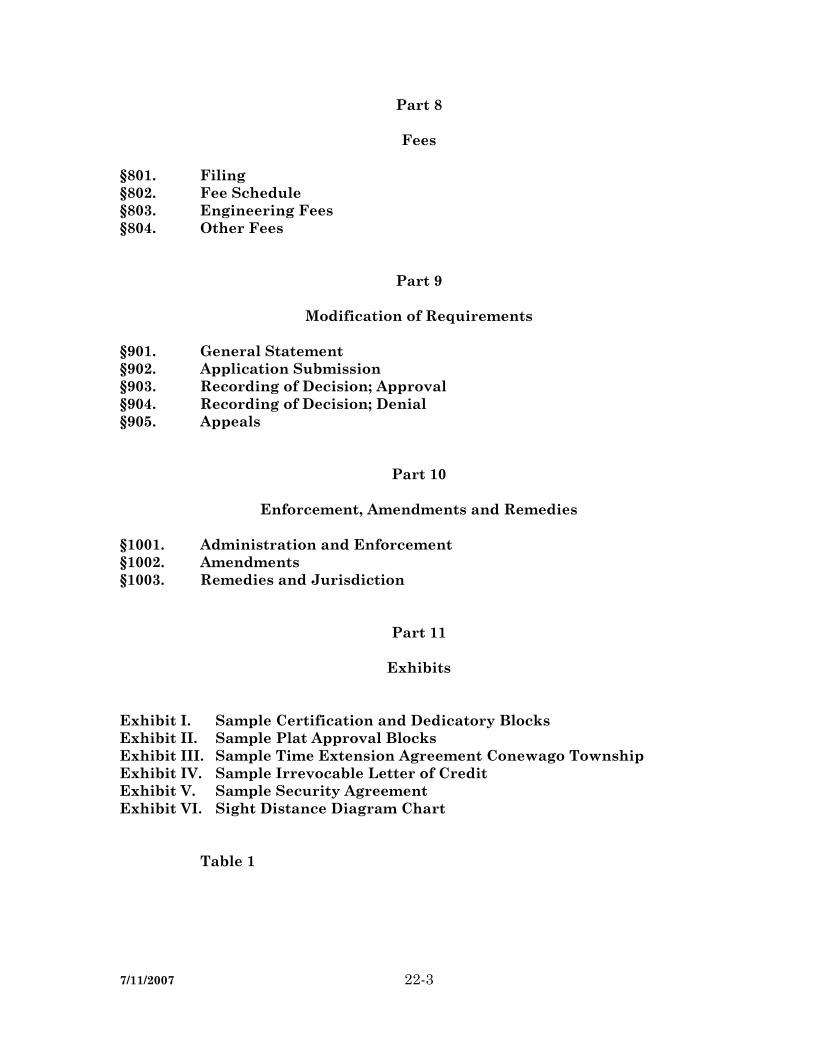
Part 8
Fees
§801. Filing §802. Fee Schedule §803. Engineering Fees §804. Other Fees
Part 9
Modification of Requirements
§901. General Statement §902. Application Submission §903. Recording of Decision; Approval §904. Recording of Decision; Denial §905. Appeals
Part 10
Enforcement, Amendments and Remedies
§1001. Administration and Enforcement §1002. Amendments §1003. Remedies and Jurisdiction
Part 11
Exhibits Exhibit I. Sample Certification and Dedicatory Blocks Exhibit II. Sample Plat Approval Blocks Exhibit III. Sample Time Extension Agreement Conewago Township Exhibit IV. Sample Irrevocable Letter of Credit Exhibit V. Sample Security Agreement Exhibit VI. Sight Distance Diagram Chart Table 1


(22, Part 1)
7/11/2007 22-5
Part 1
Short Title §101. Short Title. These regulations shall be known and may be cited as “The Conewago Township Subdi-vision and Land Development Ordinance.” (Ord. 1989-1, 9/13/1989, §101)


(22, Part 2)
7/11/2007 22-7
Part 2
Purpose, Authority, Application and Interpretation
§201. Purpose. The Purpose of this Chapter is to provide for harmonious development of the Township and County by: A. Assuring the orderly and efficient integration of subdivisions into the devel-
opment of Conewago Township. B. Assuring sites suitable for building purposes and human habitation. C. Assuring conformance of subdivision plans with public improvement plans. D. Assuring coordination of inter, and intra-municipal public improvement
plans and programs. E. Assuring the protection of water resources and drainageways. F. Assuring the efficient movement of traffic. G. Assuring the management of stormwater run-off problem areas. H. Assuring equitable handling of all subdivision plans by providing uniform
standards and procedures. I. Assuring the greater health, safety, and welfare of the citizens of the Town-
ship of Conewago. J. Assuring the efficient and orderly extension of community services and fa-
cilities at minimum cost and maximum convenience. K. Regulating the subdivision and development of land within any flood hazard
area or floodplain district in order to promote the health, safety and welfare of the citizens of the Township.
L. Requiring that each lot in flood prone areas includes a safe building site
with adequate access, and that public facilities which serve such uses be de-signed and installed to minimize flood damage.
M. Assuring that reservations, if any, by the developer of any area designated
for use as public grounds shall be suitable in size and location for their des-ignated uses.

SUBDIVISION AND LAND DEVELOPMENT
22-8 7/11/2007
N. Guiding the future growth and development of Conewago Township in ac-cordance with the adopted comprehensive plan.
O. Assuring that documents prepared as part of a land ownership transfer fully
and accurately describe the parcel of land being subdivided and the new parcel(s) thus created.
(Ord. 1989-1, 9/13/1989, §201) §202. Authority. 1. The Conewago Township Board of Supervisors shall have the authority to approve
or disapprove all preliminary and final subdivision or land development plat ap-plications as required in this Chapter.
2. The Conewago Township Planning Commission is hereby designated as the
agency which shall review and make recommendations on all subdivision and land development plat applications as required herein, prior to action on same by the Board of Supervisors.
(Ord. 1989-1, 9/13/1989, §202) §203. County Review. Applications for subdivision and land development located within the Township of Conewago shall be forwarded upon receipt, with the appropriate review fee, to the Dau-phin County Planning Commission for review and report. The Township Board of Su-pervisors shall not approve such applications until the County review report is received or until the expiration of 30 days from the date the application was forwarded to the County Planning Commission. As evidence of their review and report, officials of the County Planning Commission shall sign final plats which have been formally approved by the Township before such plats are presented for recording. (Ord. 1989-1, 9/13/1989, §203) §204. Application of Regulations. 1. No subdivision or land development of any lot or parcel of land located in Cone-
wago Township shall be effected; no street, sanitary sewer, storm sewer, water main, or other facilities in connection therewith shall be laid out, constructed, opened or dedicated for public use or travel, or for the common use of occupants of buildings thereon unless and until a final subdivision plat has been approved by the Board of Supervisors and publicly recorded in the manner prescribed herein, nor otherwise, except in strict accordance with the provisions of this Chapter.

(22, Part 2)
7/11/2007 22-9
2. No lot in a subdivision may be sold, no permit to erect or alter any building upon land in a subdivision or land development may be issued, and no building may be erected or altered in a subdivision or land development, unless and until a final subdivision plat has been approved by the Board of Supervisors and recorded, and until construction of the improvements required in the manner prescribed herein.
3. Unit or condominium land development of real property is included within the
meaning of land development as defined herein, and must comply with these regu-lations. Such compliance shall include, but not be limited to, the filing of prelimi-nary and final plats, payment of established fees and charges, location of each structure and clear definition of each unit, public easements, common areas, im-provements and all easements appurtenant to each unit.
4. Preliminary and final plats shall indicate the location of each structure and
clearly define each unit and shall indicate public easements, common areas, and improvements, all easements appurtenant to each unit and improvements to pub-lic rights-of-way.
5. All subdivision and land development plats are subject to the Zoning Ordinance
[Chapter 27] as it applies to use and density requirements, setbacks, height, park-ing and other such zoning-related features.
(Ord. 1989-1, 9/13/1989, §204) §205. Interpretation. In interpreting and applying the provisions of this Chapter, they shall be held to be minimum requirements for the promotion of public health, safety, comfort, convenience, and greater welfare. In any case where a provision of this Chapter is found to conflict with the provision of a zoning, building, fire, safety or health ordinance or code of this Township or law, rule or regulation of the Commonwealth of Pennsylvania, the provi-sions which establish the higher standard for the promotion and protection of the health and safety of the people shall prevail. In any case where a provision of this Chapter is found to be in conflict with the provisions of another ordinance or code of this Township or law, rule or regulation of the Commonwealth of Pennsylvania which establishes a lower standard for the promotion and protection of the health and safety of the people, the provisions of this Chapter shall be deemed to prevail. In addition, should the Penn-sylvania Municipalities Planning Code be amended to establish mandatory provisions which would be inconsistent herewith, those mandatory provisions shall be deemed to be incorporated herein by reference thereto without further amendment of this Chapter. (Ord. 1989-1, 9/13/1989, §205)

(22, Part 3)
7/11/2007 22-11
Part 3
Definitions
§301. Definitions. Unless otherwise expressly stated, the following words shall, for the purpose of this Chapter, have the meaning herein indicated. Words expressed in the plural include their singular meanings; the present tense shall include the future; words used in the masculine gender shall include the feminine and the neuter; the words “shall” and “will” are mandatory; the words “should” and “may” are permissive. It is the intent of this Chapter to parallel the Pennsylvania Municipalities Planning Code. Therefore, if a defi-nition is not included herein, reference should be made thereto. ACCESSORY BUILDING — a subordinate building or a portion of the main building on a lot, the use of which is customarily incidental to that of the main or principal building. ALLEY — a public thoroughfare, other than a street or side street, which affords only secondary means of access to abutting properties and not intended for general traffic circulation. APPLICANT — a landowner or developer, as hereinafter defined, who has filed an ap-plication for development including his heirs, successors and assigns. APPLICATION FOR DEVELOPMENT — every application, whether preliminary or final, required to be filed and approved prior to start of construction or development in-cluding, but not limited to, an application for a building permit, for the approval of a subdivision plat or plan, or for the approval of a development plan. BASE FLOOD ELEVATION — the one-hundred-year flood elevation as indicated on the Flood Insurance Study and Flood Insurance Rate Map (FIRM), as revised, for the Town-ship of Conewago, Dauphin County, Pennsylvania, prepared by the Federal Emergency Management Agency, Federal Insurance Administration. BLOCK — an area bounded by streets. BOARD OF SUPERVISORS — the Board of Supervisors of Conewago Township. BUILDING SETBACK LINE — the line within a property defining the required mini-mum distance between any principal or accessory structure and the adjacent right-of-way, and the line defining side and rear yards, where required. CARTWAY — that improved portion of a street or alley within which vehicles are per-mitted, including travel lanes and parking areas, but not including shoulders, curbs, sidewalks or swales.

SUBDIVISION AND LAND DEVELOPMENT
22-12 7/11/2007
CLEAR SIGHT TRIANGLE — a triangular-shaped portion of land established at street intersections in which nothing is erected, placed, planted or allowed to grow in such a manner as to limit or obstruct the sight distance of motorists entering or leaving inter-section (Refer to Exhibit VI). COMMISSION — the Conewago Township Planning Commission. COMMON ELEMENTS — land amenities, parts of buildings, central services and utili-ties, and any other elements and facilities used by all unit owners and are designated as common elements. These elements may include, but are not limited to: (1) The land on which the building is located and portions of the building which are
not included in a unit. (2) The foundation, structural parts, supports, main walls, roofs, basements, halls,
corridors, lobbies, stairways, entrances and exits of the building. (3) The yards, parking area, and driveways. (4) Portions of the land and building used exclusively for the management, operation
or maintenance of the common elements. (5) Installations of all central services and utilities. (6) All other elements of the building necessary or convenient to its existence, man-
agement, operation, maintenance and safety or normally in common use. (7) Such other facilities as are designated as common elements. COMMON OPEN SPACE — a parcel or parcels of land or an area of water, or a combi-nation of land and water within a development site and designed and intended for the use or enjoyment of residents of a residential development, not including streets, off-street parking areas, and areas set aside for public activities. CONDOMINIUM — real estate, portions of which are designated for separate owner-ship and the remainder of which is designated for common ownership solely by the own-ers of those portions. Real estate is not a condominium unless the undivided interests in the common elements are vested in the unit owners. CONDOMINIUM ASSOCIATION — the community association which administers and maintains the common property and common elements of a condominium. COUNTY — County of Dauphin, Pennsylvania. CROSS-WALK — right-of-way, publicly or privately owned, intended to furnish access of pedestrians.

(22, Part 3)
7/11/2007 22-13
CUL-DE-SAC — a minor street open at one end for vehicular and pedestrian access with the opposite end terminating in a vehicular turn around. CULVERT — a drain, ditch or conduit not incorporated in a closed system, that carries drainage water under a driveway, roadway, railroad, pedestrian walk or public way. CURB — a stone or concrete boundary usually marking the edge of the roadway or paved area. CURB CUT — the opening along the curb line at which point vehicles may enter or leave the roadway. CUT — an excavation. The difference between a point on the original ground and desig-nated point of lower elevation of the final grade. Also, the material removed in excava-tion. DEVELOPER — any landowner, agent of such landowner or tenant with the permission of such landowner, who makes or causes to be made a subdivision of land or a land de-velopment. DEVELOPMENT PLAN — the provisions for development, including a planned resi-dential development, a plat of subdivision, all covenants relating to use, location and bulk of buildings and other structures, intensity of use or density of development, streets, ways and parking facilities, common open space and public facilities. The phrase “provisions of development plan” when used in this Chapter shall mean the writ-ten and graphic materials referred to in this definition. DRAINAGE — (1) Surface water runoff. (2) The removal of surface or groundwater from land by drains, grading or other
means which include runoff controls to minimize erosion and sedimentation dur-ing and after construction of development, the means for preserving the water supply and the prevention or alleviation of flooding.
DRAINAGE FACILITY — any ditch, gutter, culvert, storm sewer or other structure de-signed, intended, or constructed for the purpose of diverting surface waters from or car-rying surface waters off streets, public rights-of-way, parks, recreational areas or any part of any subdivision or contiguous land areas. DRAINAGE SYSTEM — pipes, swales, natural features and manmade improvements designed to carry drainage. DRIVEWAY — a private roadway providing access for vehicles to a parking space, ga-rage, dwelling or other structure.
SUBDIVISION AND LAND DEVELOPMENT
22-14 7/11/2007
DWELLING — a building or structure designed for living quarters for one or more fami-lies, including mobile homes which are supported either by a foundation or by blocks or jacks or otherwise permanently attached to the land, but not including hotels, rooming houses or other accommodations used for transient occupancy. DWELLING, INDUSTRIALIZED HOUSING — any structure designed primarily for residential occupancy, except a mobile home, which is wholly or in substantial part made, fabricated, formed or assembled in manufacturing facilities for installation or as-sembly and installation on the building site in such a manner that all concealed parts or processes of manufacture cannot be inspected at the site without disassembly, damage or destruction. DWELLING, MOBILE/MANUFACTURED HOME — a transportable, single-family dwelling intended for permanent occupancy, contained in one unit, or in two or more units designed to be joined into one integral unit capable of again being separated for repeated towing, which arrives at a site complete and ready for occupancy except for minor and incidental unpacking and assembly operations, and constructed so that it may be used without a permanent foundation. DWELLING, MULTIFAMILY — a building used by three or more families living inde-pendently of each other and doing their own cooking including apartment houses, row houses or townhouses. DWELLING, SINGLE-FAMILY DETACHED — a building used by one family, having only one dwelling unit and having two side yards. DWELLING, SINGLE-FAMILY, SEMI-DETACHED — a dwelling used by one family, having one side yard, and one party wall common with another dwelling. DWELLING, SINGLE-FAMILY, ATTACHED (TOWNHOUSES) — a building used by one family and having two party walls in common with other buildings. DWELLING, TWO FAMILY, DETACHED (DUPLEX) — a building used by two fami-lies, with one dwelling unit arranged over the other, and having two side yards. EASEMENT — a right-of-way granted for the limited use of land for public or quasi-public purposes. ENGINEER, TOWNSHIP — a registered professional engineer in Pennsylvania desig-nated by the Township to perform the duties of engineer as herein specified. ENGINEER, PROFESSIONAL — an individual licensed and registered under the laws of the Commonwealth of Pennsylvania to engage in practice of engineering. A profes-sional engineer may not practice land surveying unless licensed as set forth in P.L. 913, No. 367; however, a professional engineer may perform engineering surveys. ENGINEERING LAND SURVEYS — surveys for: (1) the development of any tract of land including the incidental design of related improvements, such as line and grade

(22, Part 3)
7/11/2007 22-15
extension of roads, sewers and grading but not requiring independent engineering judgment; provided, however, that tract perimeter surveys shall be the function of the professional land surveyor; (2) the determination of the configuration or contour of the earth’s surface, or the position of fixed objects thereon or related thereto by means of measuring lines and angles and applying the principals of mathematics, photogram-metry or other measurement methods; (3) geodetic or cadastral surveys, underground surveys and hydrographic surveys; (4) sedimentation and erosion control surveys; (5) the determination of the quantities of materials; (6) tests for water percolation in soils; and (7) the preparation of plans and specifications and estimates of proposed work as described herein. ENGINEERING SPECIFICATIONS — the engineering specifications of the Township regulating the installation of any required improvements or for any facility installed by any owner, subject to public use. EROSION — the detachment and movement of soil or rock fragments, or the wearing away of the land surface by water, wind, ice and gravity. EXCAVATION — any act by which earth, sand, gravel, rock or any other similar mate-rial is dug into, cut, quarried, uncovered, removed, displaced, relocated or bulldozed. It shall include the conditions resulting therefrom. EXISTING GRADE — the vertical location of the ground surface prior to excavation or filling. FILL — any act by which earth, sand, gravel, rock or any other material is placed, pushed, dumped, pulled, transported or moved to a new location above the natural sur-face of the ground or on top of the stripped surface and shall include the conditions re-sulting therefrom. The difference in elevation between a point on the original ground and a designated point of higher elevation on the final grade. The material used to make a fill. FINISHED GRADE — the proposed elevation of the land surface of a site after comple-tion of all site preparation work. FLOOD — a temporary inundation of normally dry land areas. FLOOD, BASE (ONE-HUNDRED-YEAR FLOOD) — a flood that, on the average, is likely to occur once every 100 years (i.e. one that has a 1% chance of occurring each year, although the flood may occur in any year). FLOOD FRINGE — that portion of the floodplain outside the floodway. FLOOD HAZARD BOUNDARY AND FLOODWAY MAP (FHBM) — an official map of a community, issued by the Federal Insurance Administration. FLOOD HAZARD, AREAS OF SPECIAL — the land in the floodplain within a commu-nity subject to a 1% or greater chance of flooding in any given year.
SUBDIVISION AND LAND DEVELOPMENT
22-16 7/11/2007
FLOODPLAIN — (1) A relatively flat or low land area, comprised of the floodway area and the flood-
fringe area, which is subject to partial or complete inundation from an adjoining or nearby stream, river or watercourse.
(2) An area subject to the unusual and rapid accumulation or runoff of surface waters
from any source. FLOODPROOFING — any combination of structural and non-structural additions, changes or adjustments to proposed and existing structures which reduce or eliminate flood damage to real estate or improved real property, water and sanitary facilities, structures and their contents. FLOODWAY — the designated area of a floodplain required to carry and discharge flood waters of a given magnitude. For the purposes of this Chapter the floodway shall be capable of accommodating a flood of the one-hundred-year magnitude. FUTURE RIGHT-OF-WAY — (1) Right-of-way width required for the expansion of existing streets to accommodate
anticipated future traffic loads. (2) A right-of-way established to provide future access to or through undeveloped
land. GOVERNING BODY — the Board of Supervisors of Conewago Township, Dauphin County, Pennsylvania. IDENTIFIED FLOODPLAIN AREA or DISTRICT — those floodplain areas specifically designated in the Zoning Ordinance [Chapter 27] as being inundated by the one-hundred-year flood. Included would be areas identified as the Floodway (FW) and the Flood Fringe (FF). IMPROVEMENTS — those physical additions, installations and changes required to render land suitable for the use intended including, but not limited to, grading, paving, curbing, street and signs, fire hydrants, water mains, electric service, gas service, sani-tary sewers, storm drains, sidewalks, crosswalks, driveways, culverts, street shade trees, and improvements to existing water courses. LAND DEVELOPMENT — any of the following activities: (1) The improvement of one lot or two or more contiguous lots, tracts or parcels of
land for any purpose involving:
(22, Part 3)
7/11/2007 22-17
(a) A group of two or more residential or nonresidential buildings, whether pro-posed initially or cumulatively, or a single nonresidential building on a lot or lots regardless of the number of occupants or tenure.
(b) The division or allocation of land or space, whether initially or cumulatively,
between or among two or more existing or prospective occupants by means of, or for the purpose of streets, common areas, leaseholds, condominiums, building groups or other features.
(2) A subdivision of land. (3) The exclusion of certain land development from this definition of land develop-
ment is permitted only when such land development involves: (a) The addition of an accessory building, including farm buildings, on a lot or
lots subordinate to an existing principal building not to exceed 800 square feet of impervious coverage.
LANDOWNER — the legal or beneficial owner or owners of land including the holder of an option or contract to purchase (whether or not such option or contract is subject to any condition), a lessee if he is authorized under the lease to exercise the rights of the landowner, or other person having a proprietary interest in land, shall be deemed to be a landowner for the purpose of this Chapter. LOT — a designated parcel, tract or area of land established by a plat or otherwise as permitted by law and to be used, developed or built upon as a unit. LOT AREA — the area contained within the property lines of a lot as shown on a subdi-vision plat excluding space within any rights-of-way, but including the area of any easement. LOT, DOUBLE FRONTAGE — an interior lot having frontage on two sides. LOT, REVERSE FRONTAGE — lot extending between and having frontage on an arte-rial street and a minor street, and with vehicular access solely from the latter. MOBILE/MANUFACTURED HOME LOT — a parcel of land in a mobile/manufactured home park, improved with the necessary utility connections and other appurtenances necessary for the erection thereon of a single mobile home. MOBILE/MANUFACTURED HOME PARK — a parcel or contiguous parcels of land which has been so designated and improved that it contains two or more mo-bile/manufactured home lots for the placement thereon of mobile/manufactured homes. MUNICIPALITY — Conewago Township, Dauphin County, Pennsylvania. OPEN SPACE, PUBLIC — open space owned by a public agency and maintained by it for the use and enjoyment of the general public.

SUBDIVISION AND LAND DEVELOPMENT
22-18 7/11/2007
PERSON — any individual or group of individuals, partnership, copartnership, or cor-poration. PLAN, COMPREHENSIVE — an official document adopted by the Township Board of Supervisors setting forth its policies regarding the long-term development of the Town-ship; the preparation of which is based on careful studies of existing conditions and prospects for future growth of the Township. The plan shall include, but need not be limited to, plans for the use of land, transportation of goods and people, community fa-cilities and services, and a map and statement indicating the relationship of the Town-ship and its proposed development to adjacent municipalities. PLAN, SKETCH — an informal plan, not necessarily to exact scale, indicating salient existing features of a tract and its surroundings and the general layout of a proposed subdivision or land development. PLAT, FINAL — a complete and exact subdivision or land development plat, prepared for official recording as required by statute, to define property rights and proposed streets and other improvements. PLAT, PRELIMINARY — a tentative subdivision or land development plat, in lesser detail than a final plat, showing approximate proposed street and lot layout as a basis for consideration prior to preparation of a final plat. PRINCIPAL BUILDING or PRINCIPAL USE — the basic purpose for which a building or land area is occupied or intended to be occupied as proposed to accessory or incidental uses; usually classifiable as residential, commercial, manufacturing or public in nature. PRIVATE ROAD — a legally established right-of-way, other than a public street, which provides the primary pedestrian and vehicular access to one or more lots and con-structed to the standards contained in this Chapter. PROFILE LINE — means the profile of the center line of the finished surface of the street, which shall be midway between the sidelines of the street. PUBLIC — owned, operated or controlled by a government agency (Federal, State or local – including a corporation created by law for the performance of certain specialized governmental functions and the Board of Public Education). PUBLIC GROUNDS — includes (1) parks, playgrounds, trails, paths other recreational areas and other public areas; and (2) sites for schools, sewage treatment, refuse disposal and other publicly owned or operated facilities; and (3) publicly owned or operated sce-nic and historic sites. PUBLIC HEARING — a formal meeting held pursuant to public notice by the Board of Supervisors or planning agency, intended to inform and obtain public comment, prior to taking action in accordance with this Chapter.

(22, Part 3)
7/11/2007 22-19
PUBLIC MEETING — a forum held pursuant to notice under the Act of July 3, 1986 (P.L. 388, No. 84), known as the “Sunshine Act,” 53 P.S. §271 et seq. PUBLIC NOTICE — notice published once each week for two successive weeks in a newspaper of general circulation in the Township. Such notice shall state the time and place of the hearing and the particular nature of the matter to be considered at the hearing. The first publication shall be not more than 30 days and the second publication shall not be less than seven days from the date of the hearing. REAL ESTATE — any fee, leasehold or other estate or interest in, over or under land, including structures, fixtures and other improvements and interests which by custom, usage or law pass with a conveyance of land though not described in the contract of sale or instrument of conveyance. Real estate includes parcels with or without upper or lower boundaries, and spaces that may be filled with air or water. RESERVE STRIP — a strip of land adjacent to a street intended to control access to the street from an adjacent property. RIGHT-OF-WAY, STREET — a public thoroughfare for vehicular traffic and/or pedes-trian traffic, whether designated as a street, highway, thoroughfare, parkway, road, avenue, boulevard, lane, alley, or however designated. RUNOFF — the surface water discharge or rate of discharge of a given watershed after a fall of rain or snow that does not enter the soil but runs off the surface of the land. SEDIMENTATION — the process by which mineral or organic matter is accumulated or deposited by wind, water or gravity. Once this matter is deposited (or remains sus-pended in water), it is usually referred to as “sediment.” SEPTIC SYSTEM — an underground system with a septic tank used for the decomposi-tion of domestic wastes. Also referred to as an on-lot system. SERVICE DRIVE (PRIVATE) — a service way providing a secondary means of private access to abutting property and not intended for general traffic circulation. SIDEWALK — a paved, surfaced or leveled area, paralleling and usually separated from the street, used as a pedestrian walkway. SIGHT DISTANCE — the length of roadway visible to the driver of a passenger vehicle at any given point on the roadway when the view is unobstructed by traffic. SLOPE — the face of an embankment or cut section; any ground whose surface makes an angle with the plane of the horizon. Slopes are usually expressed in a percentage based upon vertical difference in feet per 100 feet of horizontal distance. SOIL STABILIZATION — chemical or structural treatment of a mass of soil to increase or maintain its stability or otherwise to improve its engineering properties.

SUBDIVISION AND LAND DEVELOPMENT
22-20 7/11/2007
STORMWATER DETENTION — any storm drainage technique that retards or detains runoff, such as detention or retention basin, parking lot storage, rooftop storage, porous pavement, dry wells or any combination thereof. STORMWATER DETENTION BASIN — a vegetated pond designed to drain completely after storing runoff only for a given storm event and release it at a predetermined rate. Also known as a dry pond. STORMWATER MANAGEMENT PLAN — the planned control of runoff to allow water falling on a given site to be absorbed or retained on site to the extent that after devel-opment the peak rate of discharge leaving the site is not greater than if the site had re-mained undeveloped. A plan showing all present and proposed grades and facilities for stormwater management. STREAM — a watercourse having a source and terminus, banks and channel through which waters flow at least periodically. STREET — a public right-of-way which affords primary vehicular pedestrian access to abutting properties, including street, highway, thoroughfare, parkway, road, avenue, boulevard, lane, or however designated. STREET GRADE — the officially established grade of the street upon which a lot fronts or in its absence the established grade of the other streets upon which the lot abuts, at the midpoint of frontage of the lot thereon. If there is no officially established grade, the existing grade of the street at such midpoint shall be taken as the street grade. STREET LINE — the dividing line between the street or road and the lot, also known as the right-of-way line. STREET, MAJOR — (1) ARTERIAL STREET — a major street or highway with fast or heavy traffic of
considerable continuity and used primarily as a traffic artery for intercommunica-tions among large areas.
(2) COLLECTOR STREET — a major street or highway which carries traffic from
minor streets to arterial streets including the principle entrance streets of a resi-dential development and streets for circulation within such a development.
STREET, MARGINAL ACCESS — a minor street which is parallel and adjacent to a limited access highway or arterial street, which provides access to abutting properties and protection from through traffic. STREET, CUL-DE-SAC — a street intersecting another street at one end and terminat-ing at the other in a vehicular turn-around. STREET, MINOR — a street used primarily for access to abutting properties.
(22, Part 3)
7/11/2007 22-21
STREET, SHOULDERS — the portion of the street, contiguous to the cartway, for the accommodation of stopped vehicles, for emergency parking, and for lateral support of base and surface courses of the pavement. STREET WIDTH — the distance between street lines measured at right angles to the center line of the street. STRUCTURE — anything constructed or erected on the ground or attached to the ground including, but not limited to, buildings, fences, factories, sheds, cabins, mobile homes and other similar items. SUBDIVIDER — the owner or authorized agent of the owner of a lot, tract or parcel of land to be subdivided for sale or development under the terms of this Chapter. SUBDIVISION — the division or redivision of a lot, tract or parcel of land by any means into two or more lots, tracts, parcels or other divisions of land including changes in ex-isting lot lines for the purpose, whether immediate or future, of lease, partition by the court for distribution to heirs or devisees, transfer of ownership or building or lot devel-opment; provided, however, that the subdivision by lease of land for agricultural pur-poses into parcels of more than 10 acres, not involving any new street or easement of access, or any residential dwelling, shall be exempted. (1) MAJOR SUBDIVISION — any subdivision involving more than six lots, parcels of
land or other divisions of land whether or not they involve new streets, additional utilities or other facilities immediate or future.
(2) MINOR SUBDIVISIONS — the subdivision of a single lot, tract or parcel of land
into six or fewer lots, tracts or parcels of land, for the purpose, whether immediate or future, of transfer of ownership or of building development, providing lots, tracts or parcels of land thereby created having frontage on an improved public street or streets and providing further that there is not created by the subdivision any new street, street easement, easements of access or need therefore.
SUBSTANTIALLY COMPLETED — where, in the judgment of the Township Engineer, at least 90% (based on the cost of the required improvements for which financial secu-rity was posted) of those improvements required as a condition for final approval have been completed in accordance with the approved plan, so that the project will be able to be used, occupied or operated for its intended use. SURFACE DRAINAGE PLAN — a plan showing all present and proposed grades and facilities for stormwater drainage. SURVEYOR, PROFESSIONAL LAND — an individual licensed and registered under the laws of this Commonwealth to engage in the practice of land surveying. A profes-sional land surveyor may perform engineering land surveys but may not practice any other branch of engineering.

SUBDIVISION AND LAND DEVELOPMENT
22-22 7/11/2007
SWALE — a low-lying stretch of land characterized as a depression used to carry sur-face water runoff. TOPOGRAPHY — the configuration of a surface area showing relative elevations. TOPSOIL — surface soils and subsurface soils which presumably are fertile soils and soil material, ordinarily rich in organic matter or humus debris. Topsoil is usually found in the uppermost soil layer called the A Horizon. TOWNSHIP — Conewago Township, Dauphin County, Pennsylvania. UNDEVELOPED LAND — any lot, tract or parcel of land which has not been graded or in any other manner prepared for the construction of a building. UNIT — that part of the property, structure or building designed or intended for any type of independent use, which has direct exit to a public street or way or to an ease-ment or right-of-way leading to a public street or way, and includes a proportionate un-divided interest in the common elements, which is assigned to the property, structure or building. UTILITY, PUBLIC or PRIVATE — (1) Any agency which under public franchise or ownership, or under certificate of
convenience and necessity, provides the public with electricity, gas, heat, steam, communication, rail transportation, water, sewage collection or other similar ser-vice.
(2) A closely regulated private enterprise with an exclusive franchise for providing a
public service. WATERCOURSE — a permanent stream, intermittent stream, river, brook, creek or a channel, swale, or ditch for water, whether natural or man-made. WETLANDS — those areas that are inundated or saturated by surface or ground water at a frequency and duration sufficient to support, and that under normal circumstances do support, a prevalence of vegetation typically adapted for life in saturated soil condi-tions, including swamps, marshes, bogs and similar areas. (The term includes but is not limited to wetland areas listed in the State Water Plan, the United States Forest Ser-vice Wetlands Inventory of Pennsylvania, the Pennsylvania Coastal Zone Management Plan and a wetland area designated by a river basin commission). (Ord. 1989-1, 9/13/1989, §301)

(22, Part 4)
7/11/2007 22-23
Part 4
Plat Specifications and Processing Procedures
§401. General Requirements. Whenever a subdivision of land or land development is desired to be effected in the Township of Conewago, Dauphin County, Pennsylvania, a plat of the layout of such subdivision or land development shall be prepared, filed and processed according to the requirements of this Chapter. (Ord. 1989-1, 9/13/1989, §401) §402. Sketch Plans. 1. Prior to the filing of a subdivision or land development plat for review and ap-
proval, the applicant is encouraged to submit a sketch plan to the Planning Com-mission for advice on the requirements necessary to achieve conformity with the standards of this Chapter and other applicable Township ordinances, as well as to alert the applicant to other factors which must be considered in the design of the subdivision or land development.
2. The plan shall be clearly labeled “Sketch Plan” and should include sufficient in-
formation to clearly indicate the character and extent of the proposed subdivision or land development and its relationship to existing conditions and facilities within the area in which it is to be located. It is recommended that sketch plan submissions include a map covering sufficient area to establish the location of the site and an informal plan of any existing or proposed streets, buildings, lot ar-rangement, utilities, significant natural features and other elements within the subdivision or land development including topographic contours.
3. Prior to the preparation of any plans, the applicant should consult the Dauphin
County Conservation District representative concerning the preparation of plans for erosion and sedimentation control.
4. The applicant shall be advised of the accessibility of public sewerage and public
water to the development site: A. If the site is located within an area planned or currently receiving water
services, the applicant shall consult with the appropriate water utility. B. If onsite systems are applicable, soil suitability testing shall be required and
verified by the local Sewage Enforcement Officer.
SUBDIVISION AND LAND DEVELOPMENT
22-24 7/11/2007
5. At this stage, the Commission shall assist the applicant in determining whether or not the site is located in an identified flood hazard area, in which case applica-ble floodplain management requirements shall be complied with.
6. If it is known that the parcels being created will be used for development requir-
ing a special permit, or for development that is considered dangerous to human life, prospective developers should check the provisions contained in the Zoning Ordinance [Chapter 27] and Building Permit Ordinance [Chapter 8], which per-tain specifically to those kinds of developments.
7. It is further advised that the applicant provide data on the sketch plan identifying
and delineating all wetlands areas located on the site. (Ord. 1989-1, 9/13/1989, §402) §403. Minor Subdivision and Land Development Application. 1. Where six or fewer lots are proposed to be subdivided from a tract of land or
where land is being transferred to be combined with an existing lot, the Board of Supervisors, being advised by the Planning Commission in response to a written request by the applicant, may waive the requirements of preliminary plat re-quirements, provided such proposal is on an existing street and no new streets are involved. In such cases the applicant shall submit a final plat as follows:
A. The final plat shall be submitted and processed as required by §406, “Final
Plat; Procedure,” and contain the following data and plat specifications: (1) Submit an erosion and sedimentation control plan as required by the
Pennsylvania Clean Streams Law and the Pennsylvania Department of Environmental Resources Erosion Control Rules and Regulations, Title 25, Part I, Subpart C, Article II, Chapter 102 – “Erosion Con-trol).” The plan content shall be prepared in accordance with the ero-sion control measures set forth in the “Erosion and Sediment Control Handbook” prepared by the Cumberland, Dauphin, and Perry County Conservation Districts.
(2) Ten copies and one mylar of the plat prepared by a registered sur-
veyor or engineer on sheets no larger than 24 inches by 36 inches clearly labeled “Final Plat,” shall be submitted containing the follow-ing information:
(a) Outline of the property from which the lot or lots are being sub-
divided. (b) Bearings and distances of the property taken from the property
deed including the primary control point.

(22, Part 4)
7/11/2007 22-25
(c) Adjacent landowners’ names. (d) Location on the property map of existing buildings, streets,
streams, and woods, septic system, and well. (e) A separate drawing of the proposed lot (scale one inch equals
100 feet) with lot area, lot number, lot dimensions, bearings and distances of lot lines, existing street right-of-way, street name and number, building setback lines, and contours, with five-foot intervals.
(f) A location map on the plat (minimum scale one inch equals
1,000 feet) showing property location, streets and other perti-nent information, in sufficient detail to adequately identify the property location.
(g) Name of the zoning district in which the site is located. (h) Additional data required on the plat. (i) Name, address, and telephone number of owner or appli-
cant. (ii) Name, address and telephone number and seal of profes-
sional engineer certifying engineering aspects and profes-sional land surveyor certifying accuracy of plat survey (as defined herein). (Example contained in Exhibit I of this Chapter.)
(iii) Date of plat preparation. (iv) Municipality where property is located. (v) North point and scale. (vi) Certification of ownership and dedicatory statement
signed by owner (Exhibit I of this Chapter). (vii) Notary public and recording statement (Exhibit I herein). (viii) Approval blocks to be signed by the Planning Commission
and the Board of Supervisors (Example contained in Ex-hibit II herein).
(ix) Location and description of survey monuments shown on
the plat.

SUBDIVISION AND LAND DEVELOPMENT
22-26 7/11/2007
(x) Proposed protective covenants running with the land, if any.
(xi) Reference to recorded subdivision plats of adjoining plat-
ted land by record name, date and number. (xii) When applicable, a copy of the “Sewage Module for Land
Development” or other equivalent documentation ap-proved by the Department of Environmental Protection in compliance with the requirements of the Pennsylvania Sewage Facilities Act and Chapter 71 of Title 25 of the Pennsylvania Code. [Ord. 1997-1]
(xiii) Compliance with §405(1)(C) of this Chapter pertaining to
applications located in a flood hazard area. (xiv) Where the proposed subdivision or land development
abuts a State highway (Pennsylvania route or United States route), evidence in writing from the Pennsylvania Department of Transportation indicating the Depart-ment’s concurrence with the proposed design for driveway access and drainage required for issuance of the Depart-ment’s highway occupancy permits, and a note added to the plat as follows:
“No building permit will be issued for any lot or parcel
which will require access to a State Highway until author-ized by a Pennsylvania Department of Transportation highway occupancy permit.”
Where the proposed subdivision or land development abuts a Township street, evidence in writing indicating proposed driveway and street intersections comply with clear-sight distance standards contained in this Chapter, and a note added to the plat as follows: “No building per-mit will be issued until a Township highway occupancy permit has been issued.”
(xv) When any portion of the tract proposed for subdivision or
land development is located within an identified flood dis-trict or floodplain area, the following information shall be required as part of the final plat and shall be prepared by a registered engineer or surveyor:
(aa) The exact location and elevation of all proposed
buildings, structures, roads and public utilities to be constructed within any identified floodplain area or district. All such maps shall show contours at inter-
(22, Part 4)
7/11/2007 22-27
vals of two feet and identify accurately the bounda-ries of the floodplain area, and all be verified by the Township Engineer.
(bb) Submission of the final plat shall also be accompa-
nied by all required permits, related permits and re-lated documentation from the Department of Envi-ronmental Protection, and any other Commonwealth agency, or local municipality where any alteration or relocation of a stream of watercourse is proposed. In addition, documentation shall be submitted indicat-ing that all affected adjacent municipalities have been notified of the proposed alteration or reloca-tion. The Department of Community Affairs and the Federal Insurance Administrator shall also be noti-fied whenever any such activity is proposed.
(xvi) A final stormwater management plan, approved by the
Township Engineer. (xvii) If water is to be provided by means other than private
wells owned and maintained by the individual owners of lots within the subdivision or development, applicants shall present evidence to the Board of Supervisors that the subdivision is to be supplied by a certified public util-ity, a bona fide cooperative association of lot owners, or by a municipal corporation, authority or utility. A copy of a certificate of public convenience from the Pennsylvania Public Utility Commission or an application for such cer-tificate, a cooperative agreement or a commitment or agreement to service the area in question, whichever is appropriate, shall be acceptable.
(xviii) Such other data as may be required by the Planning
Commission or Board of Supervisors in the enforcement of this Chapter.
(Ord. 1989-1, 9/13/1989, §403; as amended by Ord. 1997-1, 1/6/1997) §404. Preliminary Plat; Procedure. 1. The applicant shall, not less than 14 calendar days prior to the regular meeting of
the Commission at which consideration is desired, file with the Township Secre-tary the appropriate filing fees and 10 copies of a preliminary plat of the proposed subdivision or land development and other required data and maps. The applicant shall submit concurrently with the preliminary plat, a copy of the sewage “Plan Revision Module for Land Development,” if applicable.

SUBDIVISION AND LAND DEVELOPMENT
22-28 7/11/2007
2. Upon filing the plat with the Township Secretary, the applicant shall within three
working days forward a copy with the appropriate review fee to the Dauphin County Planning Commission. The Township Secretary will likewise forward cop-ies to the Township Engineer and Township Zoning Officer, and may, as appro-priate, forward copies to affected public utilities, school districts, Dauphin County Conservation District, fire departments, emergency response agencies and other public agencies for review and report to the Township. The Board of Supervisors, upon the recommendation of the Commission, shall act on any such preliminary plat and communicate their decision to the applicant not later than 90 days fol-lowing the date of the regular meeting of the Board of Supervisors or the Planning Commission (whichever first reviews the application) following the date the appli-cation is filed; provided that, should the said next regular meeting occur more than 30 days following the filing of the application, the said ninety-day period shall be measured from the 30th day following the day the application has been filed. In the event that any waiver or modification of requirements from this Chapter is requested by the applicant or is deemed necessary for approval, the waiver or modification and the reasons for its necessity shall be entered in the re-cords of the Commission.
3. The Dauphin County Planning Commission shall review the preliminary plat and
data and shall return a copy of a written report indicating their recommendations to the Township Board of Supervisors within 30 days of their receipt of same or forfeit their right to review.
4. The Board of Supervisors shall determine whether the plat shall be approved, ap-
proved with conditions acceptable to the applicant, or disapproved. The decision of the Board of Supervisors shall be in writing and shall be communicated to the ap-plicant personally or mailed to him at his last known address, not later than 15 days following their decision. If the plat is approved with conditions, the applicant shall respond to the Board of Supervisors indicating acceptance or rejection of such conditions. Such response shall be in writing, signed by the applicant, and be received by the Township Secretary within 10 calendar days of receipt by the ap-plicant of the Board of Supervisors decision to approve the plat with conditions. Approval of the plat shall be rescinded automatically upon the applicant’s failure to accept or reject such conditions in the manner and within the time frame noted above.
5. Before acting on any subdivision plat, the Board of Supervisors, may hold a public
hearing thereon after public notice. 6. When the application is not approved in terms as filed, the decision shall specify
the defects found in the application and shall, in each case, cite the applicable provisions of this Chapter.
7. Failure of the Board of Supervisors to render a decision and communicate it to the
applicant within the time and in the manner required herein shall be deemed an approval of the application in terms as presented unless the applicant has agreed

(22, Part 4)
7/11/2007 22-29
in writing to an extension of time or change in the prescribed manner of presenta-tion of communication of the decision, in which case, failure to meet the extended time or change in manner of presentation of communication shall have like effect. (A sample “Agreement to Extend the Time for Rendering and Communicating a Decision on Certain Preliminary and/or Final Subdivision Plans” is contained in Exhibit III of this Chapter.)
8. Approval of the preliminary plat constitutes approval of the proposed subdivision
or land development with respect to the general design, the approximate dimen-sions and other planned features. Preliminary approval binds the developer to the general scheme of the plat as approved. Preliminary approval does not authorize the recording, sale or transfer of lots.
9. Preliminary approval shall expire within five years after being granted. An exten-
sion of time may be requested by the applicant and approved by the Board of Su-pervisors in accordance with §508(4) of the Pennsylvania Municipalities Planning Code, Act 247, as amended. Requests for extension shall be submitted to the Board of Supervisors 30 days prior to any prevailing expiration date.
(Ord. 1989-1, 9/13/1989, §404) §405. Preliminary Plat; Specifications. 1. The following shall he submitted in application for review and approval of a pre-
liminary plat. A. Ten copies and one reproducible mylar of a map or series of maps or sheets
not larger than 24 inches by 36 inches drawn to scale not smaller than 100 feet to the inch, unless otherwise specified herein, clearly labeled “Prelimi-nary Plat,” and showing the following:
(1) Name or identifying title of the proposed subdivision or land develop-
ment. (2) The date the plat was prepared, the dates of any subsequent revisions
thereto after the plat has been submitted, and a description of such revisions, if any.
(3) North point and scale. (4) A diagram at a scale not less than 1,000 feet to the inch, covering suf-
ficient area to establish the location of the site within the Township. (5) Name, address and phone number of the owner or applicant. (6) The names of owners of all abutting unplotted land and the names of
all abutting subdivisions.

SUBDIVISION AND LAND DEVELOPMENT
22-30 7/11/2007
(7) Name, address, telephone number and seal of the professional engi-
neer certifying engineering aspects and professional land surveyor certifying accuracy of plat survey (as defined in this Chapter).
(8) Tract boundaries by bearings and distances. (9) All existing property lines, easements and rights-of-way and the pur-
pose for which the easements or rights-of-way will be or have been es-tablished.
(10) All existing streets on or adjacent to the tract, including name, right-
of-way width and pavement width. (11) All existing buildings, sanitary and storm sewers, water mains, cul-
verts, fire hydrants and other significant manmade features on or ad-jacent to the tract.
(12) Water courses, marshes, rock outcrops and wooded areas. (13) Existing and proposed contours at vertical intervals of five feet or, in
the case of land having a slope of 2% or less, at such lesser intervals as may be necessary for satisfactory study and planning of the tract. Datum to which contour elevations refer shall be U.S. Coast and Geo-logic Survey datum or such other source approved by the Township Engineer.
(14) Total acreage, number of lots, minimum lot areas, density, use of land,
setback lines and zoning districts in tabular form. The applicant shall be required to delineate the various phased sections (if applicable) and sequence of final plat submissions.
(15) Location, width and approximate grade of all proposed streets, alleys,
rights-of-way and easements; lot numbers, proposed lot lines with ap-proximate dimensions and lot areas; proposed minimum setback line for each street and yard; playgrounds, public buildings, public areas and parcels of land proposed to be dedicated or reserved for public use.
(16) Location of any proposed site improvements such as curbs, sidewalks,
drives, street trees, fire hydrants, and, when the proposed develop-ment includes other than individual residences the type of land use and the location of structures and parking facilities.
(17) An indication of the general location of proposed water mains, sani-
tary sewers and stormwater catch basins and lines. The preliminary size of each line should be shown as well as the locations of or dis-tances to any existing line to be connected to, with the size of such ex-isting lines indicated.

(22, Part 4)
7/11/2007 22-31
(18) General plans for the collection, detention, or retention of run-off of
surface water and its out-fall together with design analyses and other supporting data.
(19) A preliminary soil erosion and sedimentation control plan. B. Where applicable, a Plan Revision Module for Land Development shall be
the responsibility of the applicant and shall be prepared in accordance with the rules and regulations of the Pennsylvania Department of Environmental Protection. The completed module shall accompany the preliminary plat submission.
C. Where the subdivision and/or land development lies partially or completely
within any identified floodplain area or district or where such activities bor-der on any identified floodplain area or district, the preliminary plat shall include the following information:
(1) The location and elevation of proposed roads, utilities, and building
sites, fills, flood or erosion protection facilities. (2) The one-hundred-year flood elevations, which shall be verified by the
Township Engineer. (3) Areas subject to special deed restrictions. (4) Contours at intervals of two or five feet depending upon the slope of
the land and identify accurately the boundaries of the floodplain areas or districts.
D. Evidence of submission of a copy of the plat, where more than six dwelling
units are proposed in a subdivision or land development, to the school dis-trict in which the subdivision or land development is located.
E. All residential developments or subdivisions containing 15 or more dwelling
units or residential lots and all nonresidential developments (with the ex-ception of agricultural development) that generate 20 or more new peak hour trips or 150 total trips per day shall provide studies and reports in ac-cordance with the requirements of this Section. All applicants with devel-opments that do not meet the above stated criteria shall submit the infor-mation required in §405(1)(E)(2)(d).
(1) Applicant is responsible for assessing the traffic impacts associated
with a proposed development that meets any condition set forth above. The Township will review the applicant’s assessment and supply available data upon request to aid the applicant in preparing the study. The applicant shall be responsible for all data collection efforts required in preparing a traffic impact study including peak period

SUBDIVISION AND LAND DEVELOPMENT
22-32 7/11/2007
turning movement counts. In addition, the applicant is responsible for ensuring that any submitted development plans meet the minimum state and local standards for geometric design. The study shall be conducted only by a professional engineer that has verifiable experi-ence in traffic engineering. Upon submission of a draft study, the Township may review the data sources, methods and findings and provide comments in written form. The applicant will then have the opportunity to incorporate necessary revisions prior to submitting a final study.
(2) Traffic Impact Study Contents. A traffic impact study prepared for a
specific site development proposal shall follow the basic format shown below. Additions or modifications should be made for a specific site, when appropriate. This basic format allows for a comprehensive un-derstanding of the existing site, future conditions without the pro-posed use and the impacts associated with the proposed development plan.
(a) This Section identifies the land use and transportation setting
for the site and its surrounding area. (i) Site and Study Area Boundaries. A brief description of the
size of the land parcel, general terrain features, legal right-of-way lines of the highway, and the location within the jurisdiction and the region should be included in this Section. In addition, the roadways that afford access to the site and are included in the study area should be identi-fied. The exact limits of the study area should be based on engineering judgment and an understanding of existing traffic conditions at the site. In all instances, however, the study limits must be mutually agreed upon by the devel-oper, its engineer and the Township.
(ii) Site Description. This Section should contain a brief nar-
rative that describes the proposed development in terms of its function, size and near and long term growth potential. This description should be supplemented by a sketch which clearly shows the proposed development within the site boundaries, its internal traffic circulation pattern and the location and orientation of its proposed access points.
(iii) Existing and Proposed Site Uses. The existing and pro-
posed uses of the site should be identified in terms of the various zoning categories in the jurisdiction. In addition, identify the specific use on which the study is made since a number of uses may be permitted under the existing or-dinances.

(22, Part 4)
7/11/2007 22-33
(iv) Existing and Proposed Nearby Uses. Include a complete description of the existing land uses in the vicinity of the site as well as their current zoning. The applicant should also state the proposed uses for adjacent land, if known. This latter item is especially important where large tracts of underdeveloped land are in the vicinity of the site and within the prescribed study area.
(v) Existing and Proposed Roadways and Intersections.
Within the study area, describe existing roadways and in-tersections (geometrics and traffic signal control) as well as improvements contemplated by government agencies.
(b) Analysis of Existing Conditions. This Section describes the re-
sults of the volume/capacity analysis to be completed for the roadways and intersections in the study area under existing conditions as well as any data collection efforts that are re-quired.
(i) Daily and Peak Hour(s) Traffic Volumes. Provide sche-
matic diagrams depicting daily and peak hour(s) traffic volumes for roadways within the study area. Turning movement and mainline volumes are to be presented for three-peak-hour conditions (AM, PM and site generated) while only mainline volumes are required to reflect daily traffic volumes. Include the source and/or method of com-putation for all traffic volumes.
(ii) Volume/Capacity Analyses at Critical Points. Utilizing
techniques described in the most current version of the Highway Capacity Manual, highway capacity software, or derivative nomographs, include an assessment of the rela-tive balance between roadway volumes and capacity. Per-form the analysis for existing conditions (roadway geome-try and traffic signal control) for the appropriate peak hours.
(iii) Level of Service at Critical Points. Based on the results
obtained in the previous Section, levels of service (A through F) are to be computed and presented. This Section should also include a description of typical operating con-ditions at each level of service.
(c) Analysis of Future Conditions without Development. This Sec-
tion describes the anticipated traffic volumes in the future and the ability of the roadway network to accommodate this traffic without the proposed zoning or subdivision request. The future year(s) for which projections are made will be specified by the

SUBDIVISION AND LAND DEVELOPMENT
22-34 7/11/2007
Township and will be dependent on the timing of the proposed development.
(i) Daily and Peak Hour(s) Traffic Volume. Clearly indicate
the method and assumptions used to forecast future traffic volumes in order that the Township can duplicate these calculations. The schematic diagrams depicting future traffic volumes will be similar to those described in §405(1)(E)(2)(b)(i) in terms of locations and times (daily and peak hours).
(ii) Volume/capacity Analyses at Critical Locations. Describe
the ability of the existing roadway system to accommodate future traffic (without site development). If roadway im-provements or modifications are committed for implemen-tation, present the volume/capacity analysis for these con-ditions.
(iii) Level of Service at Critical Points. Based on the results
obtained in the previous Section, determine levels of ser-vice (A through F).
(d) Trip Generation. Identify the amount of traffic generated by the
site for daily and the three peak conditions. The trip generation rates used in this phase of the analysis shall be justified and documented to the satisfaction of the Township.
(e) Trip Distribution. Identify the direction of travel for site gener-
ated traffic for the appropriate time periods. As with all techni-cal analysis steps, the basic method and assumptions used in this work must be clearly stated in order that the Township can replicate these results.
(f) Traffic Assignment. Describe the utilization of study area road-
ways by site generated traffic. The proposed traffic volumes should then be combined with anticipated traffic volumes from §405(1)(E)(2)(c) to describe mainline and turning movement vol-umes for future conditions with the site developed as the appli-cant proposes.
(g) Analysis of Future Conditions with Development. This Section
describes the adequacy of the roadway system to accommodate future traffic with development of the site.
(i) Daily and Peak Hour(s) Traffic Volumes. Provide mainline
and turning movement volumes for the highway network in the study area as well as driveways and internal circu-lation roadways for the appropriate time periods.

(22, Part 4)
7/11/2007 22-35
(ii) Volume/capacity Analyses at Critical Points. Perform a
volume/capacity analysis for the appropriate peak hours for future conditions with the site developed as proposed, similar to §§405(1)(E)(2)(c)(ii).
(iii) Level of Service at Critical Points. As a result of the vol-
ume/capacity analysis, compute and describe the level of service on the study area roadway system.
(h) All highway capacity evaluations shall consider the overall in-
tersection level of service and delay, and evaluate each approach and movement to identify any substantial values which need to be improved.
(i) Recommended Improvements. In the event that the analysis in-
dicates unsatisfactory levels of service will occur on study area roadways, a description of proposed improvements to remedy de-ficiencies should be included in this Section. These proposals would not include committed projects by the State and local ju-risdictions that were described in §405(1)(E)(2)(a) and reflected in the analysis contained in §§405(1)(E)(2)(b) and (c). The pre-ferred level of service is (C); however, a lower level of service may be permitted if the existing level of service is less than (C), provided that the permitted level shall not be lower than the ex-isting level of service. In the event that the intersec-tion/driveway accesses which are the subject of the study do not meet warrants for a traffic control device in accordance with the standards of the Pennsylvania Department of Transportation or cannot be improved to achieve a level of service of “C” due to ex-isting physical limitations such as lack of right-of-way, the per-mitted level of service may be lower than “C” if the existing level is less than “C”.
(i) Proposed Recommended Improvements. Describe the loca-
tion, nature and extent of proposed improvements to as-sure sufficient roadway capacity. Accompanying this list of improvements are preliminary cost estimates, sources of funding, timing and likelihood of implementation.
(ii) Volume/Capacity Analysis at Critical Points. Another it-
eration of the volume/capacity analysis will be described which demonstrates the anticipated results of making these improvements.
(iii) Level of Service at Critical Points. As a result of the re-
vised volume/capacity analysis presented in the previous

SUBDIVISION AND LAND DEVELOPMENT
22-36 7/11/2007
section, present levels of service for the highway system with improvements.
(j) The last Section of the report should be a clear concise descrip-
tion of the study findings. This concluding section should serve as an executive summary.
F. Subject to the applicable provisions of §604(2) of this Chapter, the applicant
shall submit a statement and justifiable analysis that there are sufficient aquifers to support onsite water systems to service the needs of the proposed development.
(Ord. 1989-1, 9/13/1989, §405; as amended by Ord. 1997-1, 1/6/1997; and by Ord. 2000-4, 8/9/2000, §1) §406. Final Plat; Procedure. 1. The applicant shall, not later than 12 months after the date of approval of the pre-
liminary plat for that portion intended to be developed, file with the Township Secretary a final plat. Such filing shall include, as part of the formal submission, all the material and other data required under the final plat specifications as listed in §407(1)(A)(1) through 407(1)(A)(19) of this Chapter. Failure to comply with the time limitation herein provided shall make the approval of the prelimi-nary plat null and void unless an extension of time is granted in accordance with §404(9) of this Chapter.
2. The final plat shall incorporate all the changes and modifications required by the
Board of Supervisors; otherwise it shall conform to the approved preliminary plat, and it may constitute only that portion of the approved preliminary plat which the applicant proposes to record and develop at the time, provided that such portion conforms with all of the requirements of this Chapter.
3. One reproducible mylar copy of the final plat and 10 prints shall be filed by the
applicant with the Township Secretary 14 days prior to the meeting of the Plan-ning Commission at which meeting consideration is desired. Upon filing the plat with the Township Secretary, the applicant shall within three working days for-ward a copy with the appropriate review fee to the Dauphin County Planning Commission. The Township Secretary shall likewise forward copies to the Town-ship Engineer and Township Zoning Officer, and may, as appropriate, forward copies to affected public utilities, school districts, Dauphin County Conservation District, fire departments, emergency response agencies and other public agencies for review and report to the Township.
4. Completion of Improvements or Guarantee Thereof Prerequisite to Final Plat Ap-
proval.

(22, Part 4)
7/11/2007 22-37
A. No plat shall be finally approved unless the streets shown on such plat have been improved to a mud-free or otherwise permanently passable condition, or improved as may be otherwise required by this Chapter and any walk-ways, curbs, gutters, street lights, fire hydrants, shade trees, water mains, sanitary sewers, storm sewers and other improvements as may be required by Part 6 have been installed in accordance with this Chapter. In lieu of the completion of any improvements required as a condition for the final ap-proval of a plat, including improvements or fees otherwise required by this Chapter, the applicant may deposit with the Township financial security in an amount sufficient to cover the costs of such improvements or common amenities including basins and other related drainage facilities, recrea-tional facilities, open space improvements, or buffer or screen plantings which may be required in accordance with any land use ordinance.
B. When requested by the applicant, in order to facilitate financing, the Board
of Supervisors, shall furnish the applicant with a signed copy of a resolution indicating approval of the final plat contingent upon the applicant obtaining a satisfactory financial security. The final plat or record plan shall not be signed nor recorded until the financial improvements agreement is exe-cuted. The resolution or letter of contingent approval shall expire and be deemed to be revoked if the financial security agreement is not executed within 90 days unless a written extension is granted by the Board of Super-visors; such extension shall not be unreasonably withheld and shall be placed in writing at the request of the developer.
C. Without limitation as to other types of financial security which the Town-
ship may approve, which approval shall not be unreasonably withheld, Fed-eral or Commonwealth chartered lending institution irrevocable letters of credit and restrictive or escrow accounts in such lending institutions shall be deemed acceptable financial security for the purposes of this Section.
D. Such financial security shall be posted with a bonding company or Federal
or Commonwealth chartered lending institution chosen by the party posting the financial security, provided said bonding company or lending institution is authorized to conduct such business within the Commonwealth.
E. Such bond or other security shall provide for and secure to the public the
completion of any improvements which may be required on or before the date fixed in the formal action of approval or accompanying agreement for completion of the improvements.
F. The amount of financial security to be posted for the completion of the re-
quired improvements shall be equal to 110% of the cost of completion esti-mated as of 90 days following the date scheduled for completion by the ap-plicant. Annually, the Township may adjust the amount of the financial se-curity by comparing the actual cost of the improvements which have been completed and the estimated cost for the completion of the remaining im-provements as of the expiration of the 90th day after either the original date

SUBDIVISION AND LAND DEVELOPMENT
22-38 7/11/2007
scheduled for completion or a rescheduled date of completion. Subsequent to said adjustment, the Township may require the applicant to post additional security in order to assure that the financial security equals said 110%. Any additional security shall be posted by the applicant in accordance with this subsection (F).
G. The amount of financial security required shall be based upon an estimate
of the cost of completion of the required improvements submitted by the ap-plicant prepared by a professional engineer licensed as such in this Com-monwealth and certified by such engineer to be a fair and reasonable esti-mate of such cost. The Township, upon the recommendation of the Township Engineer, may refuse to accept such estimate for good cause shown. If the applicant and the Township are unable to agree upon an estimate, then the estimate shall be recalculated and recertified by another professional engi-neer licensed as such in this Commonwealth and chosen mutually by the Township and the applicant. The estimate certified by the third (3rd) engi-neer shall be presumed fair and reasonable and shall be the final estimate. In the event that a third engineer is so chosen, fees for the services of said engineer shall be paid equally by the Township and the applicant.
H. If the party posting the financial security requires more than one year from
the date of posting of the financial security to complete the required im-provements, the amount of financial security may be increased by an addi-tional 10% for each one-year period beyond the first anniversary date from posting of financial security or to an amount not exceeding 110% of the cost of completing the required improvements as reestablished on or about the expiration of the preceding one-year period by using the bidding procedure provided for in this Section.
I. In the case where development is projected over a period of years, the Board
of Supervisors may authorize submission of final plats by section or stages of development subject to such requirements or guarantees as to improve-ments in future sections or stages of development as it finds essential for the protection of any finally approved section of the development.
J. As the work of installing the required improvements proceeds, the party
posting the financial security may request the Board of Supervisors to re-lease or authorize the release, from time to time, of such portions of the fi-nancial security necessary for payment to the contractor or contractors per-forming the work. Any such requests shall be in writing addressed to the Board of Supervisors, and the Board of Supervisors shall have 45 days from receipt of such request within which to allow the Township Engineer to cer-tify, in writing, to the Board of Supervisors that such portion of the work upon the improvements has been completed in accordance with the ap-proved plat. Upon such certification the Board of Supervisors shall author-ize release by the bonding company or lending institution of an amount as estimated by the Township Engineer fairly representing the value of the improvements completed or, if the Board of Supervisors fails to act within

(22, Part 4)
7/11/2007 22-39
said forty-five-day period, the Board of Supervisors shall be deemed to have approved the release of funds as requested. The Board of Supervisors may, prior to final release at the time of completion and certification by the Township Engineer, require retention of 10% of the estimated cost of the aforesaid improvements.
K. Where the Board of Supervisors accepts dedication of all or some of the re-
quired improvements following completion, the Board of Supervisors may require the posting of financial security to secure the structural integrity of said improvements as well as the functioning of said improvements in ac-cordance with the design and specifications as depicted on the final plat for a term not to exceed 18 months from the date of acceptance of dedication. Said financial security shall be of the same type as otherwise required in this Section with regard to installation of such improvements, and the amount of the financial security shall not exceed 15% of the actual cost of installation of said improvements.
L. If water mains or sanitary sewer lines, or both, along with apparatus or fa-
cilities related thereto, are to be installed under the jurisdiction and pursu-ant to the rules and regulations of a public utility or municipal authority separate and distinct from the Township, financial security to assure proper completion and maintenance thereof shall be posted in accordance with the regulations of the controlling public utility or municipal authority and shall not be included within the financial security as otherwise required by this Section.
M. If financial security has been provided in lieu of the completion of improve-
ments required as a condition for the final approval of a plat as set forth in this Section, the Township shall not condition the issuance of building, grad-ing or other permits relating to the erection or placement of improvements, including buildings, upon the lots or land as depicted upon the final plat upon actual completion of the improvements depicted upon the approved fi-nal plat. Moreover, if said financial security has been provided, occupancy permits for any building or buildings to be erected shall not be withheld fol-lowing: the improvement of the streets providing access to and from existing public roads to such building or buildings to a mud-free or otherwise per-manently passable condition, as well as the completion of all other im-provements as depicted upon the approved plat, either upon the lot or lots or beyond the lot or lots in question if such improvements are necessary for the reasonable use of or occupancy of the building or buildings.
5. Release from Improvement Bond. A. When the applicant has completed all of the necessary and appropriate im-
provements, the applicant shall notify the Board of Supervisors, in writing, by certified or registered mail, of the completion of the aforesaid improve-ments and shall send a copy thereof to the Township Engineer. The Board of Supervisors shall, within 10 days after receipt of such notice, direct and
SUBDIVISION AND LAND DEVELOPMENT
22-40 7/11/2007
authorize the Township Engineer to inspect all of the aforesaid improve-ments. The Township Engineer shall, thereupon, file a report in writing, with the Board of Supervisors, and shall promptly mail a copy of the same to the applicant by certified or registered mail. The report shall be made and mailed within 30 days after receipt by the Township Engineer of the aforesaid authorization from the Board of Supervisors; said report shall be detailed and shall indicate approval or rejection of said improvements, ei-ther in whole or in part, and if said improvements, or any portion thereof, shall not be approved or shall be rejected by the Township Engineer, said report shall contain a statement of reasons for such nonapproval or rejec-tion.
B. The Board of Supervisors shall notify the applicant, within 15 days of re-
ceipt of the Township Engineer’s report, in writing by certified or registered mail of the action of said Board of Supervisors with relation thereto.
C. If the Board of Supervisors or the Township Engineer fails to comply with
the time limitation provisions contained herein, all improvements will be deemed to have been approved and the applicant shall be released from all liability, pursuant to this performance guaranty bond or other security agreement.
D. If any portion of the said improvements shall not be approved or shall be
rejected by the Board of Supervisors, the applicant shall proceed to complete the same and, upon completion, the same procedure of notification, as out-lined herein, shall be followed.
E. Nothing herein, however, shall be construed in limitation of the applicant’s
right to contest or question by legal proceedings or otherwise, any determi-nation of the Board of Supervisors or the Township Engineer.
F. Where herein reference is made to the Township Engineer, he shall be as a
consultant thereto. G. The applicant shall reimburse the Township for the reasonable and neces-
sary expenses incurred for the inspection or improvements according to a schedule of fees adopted by resolution of the Board of Supervisors and as from time to time amended.
(1) In the event the applicant disputes the amount of any such expense in
connection with the inspection of improvements, the applicant shall, within 10 working days of the date of billing, notify the Township that expenses are disputed as unreasonable or unnecessary, in which case the Township shall not delay or disapprove a subdivision or land de-velopment application or any approval or permit related to develop-ment due to the applicant’s request over disputed engineer expenses.

(22, Part 4)
7/11/2007 22-41
(2) If, within 20 days from the date of billing, the Township and the ap-plicant cannot agree on the amount of expenses which are reasonable and necessary, then the applicant and the Township shall jointly, by mutual agreement, appoint another professional engineer licensed as such in the Commonwealth of Pennsylvania to review the said ex-penses and make a determination as to the amount thereof which is reasonable and necessary.
(3) The professional engineer so appointed shall hear such evidence and
review such documentation as the professional engineer in his sole opinion deems necessary and render a decision within 50 days of the billing date. The applicant shall be required to pay the entire amount determined in the decision immediately.
(4) In the event that the Township and applicant cannot agree upon the
professional engineer to be appointed within 20 days of the billing date, then, upon application of either party, the President Judge of the Court of Common Pleas of the Judicial District in which the Township is located (or if at the time there be no President Judge, then the sen-ior active judge then sitting) shall appoint such engineer, who, in that case, shall be neither the Township Engineer nor any professional en-gineer who has been retained by, or performed services for, the Town-ship or the applicant within the preceding five years.
(5) The fee of the appointed professional engineer for determining the
reasonable and necessary expenses shall be paid by the applicant if the amount of payment required in the decision is less than the origi-nal bill by $1,000 or more, the Township shall pay the fee of the pro-fessional engineer, but otherwise the Township and the applicant shall each pay 1/2 of the fee of the appointed professional engineer.
6. Before acting on any subdivision plat, the Board of Supervisors may hold a public
hearing thereon after public notice. 7. The Board of Supervisors, upon the recommendation of the Planning Commission,
shall act on the final subdivision or land development plat within 90 days and as prescribed in §404(2), (4), (6), and (7).
8. No changes, erasures, modifications or revisions shall be made on any final plat of
a subdivision or land development after approval has been given by the Board of Supervisors, and endorsed in writing on the plat, unless the plat is first resubmit-ted to the Board of Supervisors.
9. Within 90 days after the date of approval of a final plat by the Board of Supervi-
sors, and upon all conditions being met, the Township Engineer shall record an approved duplicate copy thereof in the office of the Recorder of Deeds of Dauphin County, retain the signed mylar for the Township records and return the remain-

SUBDIVISION AND LAND DEVELOPMENT
22-42 7/11/2007
ing recorded copies to the applicant with the plan book and page numbers indi-cated on the plat.
10. Whenever plat approval by the Board of Supervisors is required, the Dauphin
County Recorder of Deeds shall not accept any plat for recording unless such plat officially notes the approval of the Board of Supervisors and review by the Dau-phin County Planning Commission. After that plat has been approved and re-corded as provided in this Chapter, all streets and public grounds on such plat shall become a part of the Official Map of the Township.
(Ord. 1989-1, 9/13/1989, §406) §407. Final Plat; Specifications. 1. The following shall be submitted in application for review and approval of a final
plat: A. Ten copies and one mylar of the final plat in the form of a map or series of
maps on sheets no larger than 24 inches by 36 inches, drawn to scale not smaller than 100 feet to the inch and clearly labeled “Final Plat.” When more than one sheet is required, an index sheet of the entire subdivision or land development shall be shown on a sheet of the same size. The final plat shall be drawn in ink and shall show the following:
(1) Primary control points, or description and “ties” to such control points,
to which all dimensions, angles, bearings, and similar data on the subdivision or land development plat shall be referred.
(2) Tract boundary lines, right-of-way lines of streets, easements, and
other rights-of-way, and property lines of residential lots or parcels in unit, cooperative or condominium subdivisions and other sites with accurate dimensions, bearing or deflection angles, and radii, arcs, and central angles of all curves.
(3) Locations and descriptions of survey monuments. All permanent ref-
erence monuments shown and described on the plat. (4) Name, address, telephone number and seal of the professional engi-
neer certifying engineering aspects and professional land surveyor certifying accuracy of plat survey (as defined herein). (Example con-tained in Exhibit I herein of this Chapter.)
(5) Certification of title showing that the applicant is the owner of land,
agent of the landowner or tenant with permission of the landowner. (Example continued in Exhibit I of this Chapter).

(22, Part 4)
7/11/2007 22-43
(6) Statement by the owner dedicating streets, rights-of-way and any sites for public uses which are to be dedicated. (Example contained in Exhibit I of this Chapter.)
(7) Proposed protective covenants running with the land, if any. (8) Name, address and telephone number of the owner/applicant. (9) Street lighting facilities, as applicable. (10) A diagram, at a scale not less than 1,000 feet to the inch, covering suf-
ficient area to establish the location of the site within the Township. (11) Lot areas and numbers to identify each lot or parcel in unit, coopera-
tive or condominium subdivisions and/or site. (12) Purpose for which sites other than residential lots or parcels in unit,
cooperative or condominium subdivisions are dedicated or reserved. (13) Building setback lines on all lots or parcels in unit, cooperative or
condominium subdivisions and/or sites. (14) Existing and proposed contours at vertical intervals of five feet or less
as approved by the Township Engineer. (15) Names or record owners of adjoining unplatted land. (16) Reference to recorded subdivision plats of adjoining platted land by
record name, date and number. (17) A final erosion and sedimentation control plan pursuant to the rules
and regulations of the Pennsylvania Department of Environmental Protection (Title 25, Part 1, Subpart C, Article II, Chapter 102 of the Pennsylvania Code) and evidence that any required erosion and sedi-mentation control permit has been issued. If an erosion and sedimen-tation control permit is not required, the applicant shall provide evi-dence that the erosion and sedimentation control plan has been re-viewed by the County Conservation District Office; however, if the District Office does not desire to review the plan, the Board of Super-visors may, at its discretion, have the plan reviewed by the Township Engineer. The cost of the review shall be paid by the applicant.
(18) Prior to final approval of plat, where the proposed subdivision or land
development abuts a State highway (Pennsylvania route or United States route), a note shall appear on the plat which shall read: “No building permit will be issued for any lot or parcel which will require access to a State highway until authorized by a Pennsylvania De-partment of Transportation highway occupancy permit.” Where the

SUBDIVISION AND LAND DEVELOPMENT
22-44 7/11/2007
proposed subdivision or land development abuts a Township street, evidence in writing indicating proposed driveway and street intersec-tions comply with clear sight distance standard contained in this Chapter, and a note added to the plat as follows: “No building permit will be issued until a Township highway occupancy permit has been issued.”
(19) Approval blocks to be signed by the appropriate officers of the Plan-
ning Commission, Board of Supervisors and Township Engineer. (Ex-ample contained in Exhibit II of this Chapter.)
(20) Other Data. The final plat shall be accompanied by the following data
and plans as prescribed by the Planning Commission, Board of Super-visors or as required by the laws of the Commonwealth:
(a) Profiles of streets and alleys showing grades. (b) Typical cross-sections of each type of street, minor streets, col-
lector, etc., showing the width of right-of-way, width of cartway, location and width of sidewalks, if required, and location and size of utility mains.
(c) Plans and profiles of proposed sanitary and storm water sewers,
with grades and pipe size indicated, and a plan of any proposed water distribution system showing pipe sizes and location of valves and fire hydrants.
(d) Certificates of agreement to provide service from applicable util-
ity companies. (e) In the case of subdivision and land development plans proposed
for the sale of lots only, the subdivider shall include on the final plat a covenant with the land assuring the implementation by the lot owners of the erosion and sedimentation control plan, and stormwater management plan.
(f) A copy of the sewage Plan Revision Module for Land Develop-
ment approved by the Department of Environmental Protection in compliance with the requirements of the Pennsylvania Sew-age Facilities Act and §71.16 of Chapter 71 of Title 25 of the Pennsylvania Code.
(g) If water is to be provided by means other than private wells
owned and maintained by the individual owners of lots within the development, applicants shall present evidence to the Board of Supervisors that the subdivision is to be supplied by a certi-fied public utility, a bona fide cooperative association of lot own-ers, or by a municipal corporation, authority or utility. A copy of

(22, Part 4)
7/11/2007 22-45
a certificate of public convenience from the Pennsylvania Pubic Utility Commission or an application for such certificate, a coop-erative agreement or a commitment or agreement to serve the area in question, whichever is appropriate, shall be acceptable.
(h) When any portion of the tract proposed for subdivision or land
development is located within an identified floodplain district or floodplain area, the following information shall be required as part of the final plat and shall be prepared by a registered engi-neer or surveyor:
(i) The exact location and elevation of all proposed buildings,
structures, roads and public utilities to be constructed within any identified floodplain area or district. All such maps shall show contours at intervals of two feet and identify accurately the boundaries of the floodplain areas, and all be verified by the Township Engineer.
(ii) Submission of the final plat shall also be accompanied by
all required permits and related documentation the De-partment of Environmental Protection, and any other Commonwealth agency, or local municipality where any alteration or relocation of a stream or watercourse is pro-posed. In addition, documentation shall be submitted indi-cating that all affected adjacent municipalities have been notified of the proposed alteration or relocation. The De-partment of Community Affairs and the Federal Insur-ance Administrator shall also be notified whenever any such activity is proposed.
(i) Final stormwater management plan approved by the Township
Engineer. (j) Such other certificates, affidavits, endorsements, or dedications
as may he required by the Board of Supervisors or Planning Commission in the enforcement of this Chapter.
(Ord. 1989-1, 9/13/1989, §407; as amended by Ord. 1997-1, 1/6/1997)


(22, Part 5)
7/11/2007 22-47
Part 5
Design Standards
§501. Application. 1. The following principles, standards, and requirements will be applied by the
Board of Supervisors and Planning Commission in their review and evaluation of all subdivision and land development plat applications.
2. The standards and requirements contained herein shall be considered the mini-
mum for the promotion of the public health, safety, convenience, and general wel-fare.
3. Where literal compliance with the standards and requirements contained herein
is clearly impractical, the Board of Supervisors may modify or waive such through the modification of requirements process set forth in Part 9 of this Chapter.
4. Subdivision and land development plats shall give due consideration to official
plans of the Township or to such parts thereof as may be approved. 5. Proposed land uses shall conform to the Zoning Ordinance [Chapter 27], as
amended. 6. Land subject to hazards to life, health, or property, such as may arise from fire,
flood, disease, or other causes, shall not be platted for development purposes unless such hazards have been eliminated or unless the plat shall show adequate safeguards against them, which shall be approved by the appropriate regulatory agencies.
(Ord. 1989-1, 9/13/1989, §501) §502. Streets and Driveways. 1. General Standards. A. Proposed streets shall be properly related to such street plans or parts
thereof as have been officially adopted by Conewago Township and shall be coordinated with existing or proposed streets in adjoining subdivisions or land developments. Further, proposed streets shall be properly related to County, regional or State transportation plans as have been prepared and adopted.
B. Streets shall be laid out to preserve the integrity of their design. Local ac-
cess streets shall be laid out to discourage their use by through traffic and,

SUBDIVISION AND LAND DEVELOPMENT
22-48 7/11/2007
where possible, collector and arterial streets shall be designed for use by through traffic.
C. Streets shall be related to the topography so as to establish usable lots and
satisfactory street grades. D. Proposed street arrangements shall make provision for the continuation of
existing streets in adjoining areas; the proper projection of streets into ad-joining undeveloped or unplatted areas; and the continuation of proposed streets to the boundaries of the tract being subdivided.
E. New half or partial streets shall be prohibited except where the applicant
justifies to the Township that it is essential to reasonable subdivision of a tract in conformance with the other requirements and standards of these regulations and where, in addition, satisfactory assurance for dedication of the remaining part of the street can be obtained; a cul-de-sac shall be con-structed at the end of such half street which shall be of a permanent nature, unless a temporary cul-de-sac is approved, in which case a right-of-way shall be provided for the temporary turnaround area.
F. Names of new streets shall not duplicate existing or platted street names, or
approximate such names by the use of suffixes such as “lane,” “way,” “drive,” “court,” “avenue.” In approving the names of streets, cognizance should be given to existing or platted street names within the postal deliv-ery district served by the local post office. New streets shall bear the same name or number of continuation of alignment with an existing or platted street.
G. Proposed private streets (streets not offered for dedication) are prohibited. H. Proposed private service access for purposes of providing a means of secon-
dary access to a lot, are permitted as deemed appropriate by the Board of Supervisors and Township Engineer.
2. Street Classification. Three functional classifications of streets and roads, as clas-
sified in the Conewago Township Comprehensive Plan, are established as follows: A. Arterial. This classification includes highways which provide intra-county or
inter-municipal traffic of substantial volumes. Generally, these highways should accommodate operating speeds of 55 miles per hour.
B. Collector. This classification is intended to include those highways which
connect minor streets to arterial highways and generally serve intra-county and intra-municipal traffic. They may serve as traffic corridors connecting residential areas with industrial, shopping and other services. They may penetrate residential areas. Generally, these highways should accommodate operating speeds of 35 to 55 miles per hour or under.

(22, Part 5)
7/11/2007 22-49
C. Minor. This classification is intended to include streets and roads that pro-vide direct access to abutting land and connections to higher classes of roadways. Traffic volumes will be low and travel distances generally short. These streets and roads should be designed for operating speeds of 25 to 35 miles per hour or under.
3. Street Widths. A. Minimum street right-of-way and cartway widths shall be required as pre-
sented in Table 1. B. Provision for additional street width (right-of-way) may be required when
determined to be necessary by the Board of Supervisors in specific cases for: (1) Public safety and convenience. (2) Parking in commercial and industrial areas and in areas of high den-
sity development. 4. Cul-de-Sac or Dead End Streets. A. Dead-end streets are prohibited unless designed as cul-de-sac streets, or de-
signed for future access to adjoining properties in accordance with §502(1)(E).
B. Any dead-end street, for access to an adjoining development, shall be pro-
vided with a temporary, all-weather turn-around within the subdivision or/and land development; and the use of such turnaround shall be guaran-teed to the public until such time as the street is extended.
C. Cul-de-sac streets are prohibited unless justified to the Board of Supervisors
based upon unique physical circumstances or conditions, including irregu-larity, narrowness or shallowness of the site and, when permitted, the fol-lowing provisions shall provide:
(1) Cul-de-sac streets serving residential uses, permanently designed as
such, shall not exceed 500 feet in length and shall not furnish access to more than 15 dwelling units.
(2) Cul-de-sac streets serving commercial and/or industrial uses shall be
adequate for the type of use to be serviced as approved by the Town-ship Engineer but, in no case, shall exceed 500 feet in length.
(3) Unless future extension is clearly impractical or undesirable, the
turn-around right-of-way shall be placed adjacent to the tract bound-ary with sufficient additional width provided along the boundary line to permit extension of the street at full width.

SUBDIVISION AND LAND DEVELOPMENT
22-50 7/11/2007
(4) All cul-de-sac streets, whether permanently or temporarily designed as such, shall be provided at the closed end with a fully paved turn-around. The minimum radius to the pavement edge or curb line shall be 40 feet, and the minimum radius of the right-of-way line shall be 50 feet.
(5) Drainage of cul-de-sac streets shall preferably be towards the open
end. If drainage is toward the closed end it shall be conducted away in an underground storm sewer.
(6) The centerline grade on a cul-de-sac street shall not exceed 8% and
the grade of the diameter of the turn-around shall not exceed 3%. 5. Driveways. A. Private driveways on corner lots shall be located at least 40 feet from the
point of intersection of the nearest street right-of-way lines. B. In order to provide a safe and convenient means of access, grades on private
driveways shall be so designed to allow for the unimpeded flow of storm wa-ter runoff. In addition, driveways must be stabilized to their full width to prevent erosion. Entrances should be rounded at a minimum radius of 10 feet, or should have a flare construction that is equivalent to the radius at the point of intersection with the cartway edge (curb line). (Refer to Penn-sylvania Department of Transportation, “Guidelines for Design of Local Roads and Streets – Publication No. 70,” as revised.)
C. All driveways shall be located, designed and constructed in such a manner
as not to interfere or be inconsistent with the design and maintenance and drainage of, or the safe and convenient passage of traffic.
D. All driveways must have a State or Township highway occupancy permit
prior to installation. 6. Horizontal and Vertical Curves. A. In order to provide adequate sight distance and ensure proper alignment of
streets, horizontal and vertical curve design shall be in accordance with the Pennsylvania Department of Transportation, “Guidelines for Design of Lo-cal Roads and Streets Publication No. 70,” as revised.
7. Intersections. A. Streets shall intersect as nearly as possible at right angles, and no street
shall intersect another at an angle of less than 75°. B. Intersections involving the junction of more than two streets are prohibited.

(22, Part 5)
7/11/2007 22-51
C. Street intersecting another street shall either intersect directly opposite to each other, or shall be separated by at least 150 feet between centerlines, measured along the centerline of the street being intersected.
D. Intersections shall be approached on all sides by a straight leveling area,
the grade of which shall not exceed 4% within 60 feet of the intersection of the nearest right-of-way lines.
E. Intersections with major streets shall be located not less than 1,000 feet
apart, measured from centerline to centerline, along the centerline of the major street.
F. At intersections of streets the curb or edge of payment radii shall not be less
than the following:
Intersection Minimum Simple Curb Radii of
Curb or Edge of Pavement
Collector with Collector Street 35 feet
Collector with Minor Street 25 feet
Minor Street with Minor 15 feet Radius corners or diagonal cutoffs must be provided on the property lines sub-
stantially concentric with or parallel to the chord of the curb radius corners. 8. Intersection Sight Distance and Clear Sight Triangles. Adequate sight distances
and areas of view obstructions shall be provided at all intersections of streets, and for driveways intersecting a street, in accordance with Exhibit VI.
9. Street Grades. The grades of streets shall not be less than the minimum or more
than the maximum requirements listed below:
Type of Street Minimum Grade Maximum Grade
Major Streets .5% 8%
Minor Street .5% 8%
Street Intersection .5% 4% 10. Slopes of Banks Along Streets. The slope of banks along streets measured perpen-
dicular to the street centerline shall he no steeper than the following: A. One foot of vertical measurement for three feet of horizontal measurement
for fills. B. One foot of vertical measurement for two feet of horizontal measurement for
cuts.

SUBDIVISION AND LAND DEVELOPMENT
22-52 7/11/2007
11. Service Drives and Driveways. A. Direct access from residential lots to a major street shall be avoided when-
ever possible. Where such direct access cannot be avoided, adequate turn-around space shall be provided behind the right-of-way line.
B. A valid highway occupancy permit shall be obtained from the Pennsylvania
Department of Transportation or the Township. Driveways serving single-family residences shall intersect streets at angles of no less than 60°. All other driveways or service drives shall intersect streets at right angles, where possible, and in no instance shall such intersection be less than 75°.
C. The width of service drives or driveways shall be in accordance with the fol-
lowing standards: (1) For multifamily residential, mobile home parks, and all non-
residential developments or subdivisions, service drives or driveways shall be no less than 22 feet in width at the street line, and shall be clearly defined.
(2) For single-family residential subdivisions, driveways shall be no less
than 10 feet in width and no greater than 20 feet in width at the street line.
D. In order to provide for safe and convenient ingress and egress points, service
drives and driveway entrances shall be rounded at the following minimum radius.
(1) For multifamily residential, mobile home and all non-residential de-
velopments or subdivisions, service drives or driveways shall be rounded at a minimum radius of 15 feet.
(2) For single-family residential subdivisions, driveway entrances shall be
rounded at a minimum radius of 10 feet. E. The grades on service drives or driveways shall not be less than .5% and
shall not exceed the following: (1) Eight percent when access is to a collector street. (2) Ten percent when access is to a minor street. (Ord. 1989-1, 9/13/1989, §502)
(22, Part 5)
7/11/2007 22-53
§503. Easements. 1. Easements shall be provided for drainage facilities, overhead or underground util-
ity facilities in consultation with the Township Engineer, Pennsylvania Depart-ment of Transportation, and the appropriate utility companies.
A. The minimum width of such easements shall be 20 feet. Additional width
may be required by the Board of Supervisors depending on the purpose and use of the easements.
B. Wherever possible, such easements shall be centered on the side or rear lot
lines, or along the front lot lines. 2. Where a subdivision and/or land development is traversed by a watercourse,
drainageway channel or stream, there shall be provided a drainage easement, width to be determined by the Township Engineer, conforming substantially with the line of such watercourse, drainageway, channel or stream and of such width as will be adequate to preserve the unimpeded flow of natural drainage or for the purpose of widening, deepening, relocating, improving or protecting such drainage facilities or for the purpose of installing a stormwater sewer.
3. Where necessary for access to public or common lands, a pedestrian easement
shall be provided with a width of no less than 10 feet. Additional width may be re-quired by the Board of Supervisors depending on the purpose and use of the easement.
(Ord. 1989-1, 9/13/1989, §503) §504. Blocks. 1. The length, width, shape, and design of blocks shall be determined with due re-
gard to the provision of adequate sites for buildings of the type proposed, to the land use and/or zoning requirements of the Township, the topography of the land being subdivided or developed, and the requirements for safe and convenient ve-hicular and pedestrian circulation.
2. Blocks shall not exceed 1,200 feet in length, nor be less than 600 feet in length.
Where practical, blocks along collector or arterial streets shall he not less than 1,000 feet in length.
3. Residential blocks shall generally be of sufficient depth to accommodate two tiers
of lots, except where reverse frontage lots bordering an arterial or collector street are used or, where due to the contour of the land, or the necessary layout of the subdivision, there is insufficient depth between intersecting streets for such two tier design.

SUBDIVISION AND LAND DEVELOPMENT
22-54 7/11/2007
4. Blocks for commercial and industrial areas may vary from the elements of design contained in this Section if the nature of use requires other treatment. In such cases, off-street parking for employees and customers shall be provided along with safe and convenient limited access to the street system. Space for off-street load-ing shall also be provided with limited access to the street system. Extension of streets, railroad access rights-of-way, and utilities shall be provided as necessary.
5. Interior pedestrian walks shall be required in blocks exceeding 1,000 feet in
length to provide for pedestrian circulation or access to community facilities. Such walks shall be stabilized for a width of not less than four feet, shall be located in easements not less than 10 feet in width, and shall, insofar as possible, be located in the center of any such block.
(Ord. 1989-1, 9/13/1989, §504) §505. Lots. 1. General Standards. A. The size, depth, width and orientation of lots shall conform to applicable
zoning regulations of Conewago Township. B. Insofar as practical, side lot lines should be at right angles to straight street
lines or radial to curved street lines. C. Where feasible, lot lines should follow Township boundaries rather than
cross them, in order to avoid jurisdictional problems. D. If, after subdividing, there exist remnants of land, they shall be either: (1) Incorporated in existing or proposed lots. (2) Legally dedicated to public use, if acceptable to the Township. 2. Lot Frontage. A. All lots shall abut a public street existing or proposed. B. Double or reverse frontage lots shall be avoided except where required to
provide separation of residential development from major streets or to over-come specific disadvantages of topography or orientation.
C. No residential lots shall be created which front upon a limited access high-
way. Furthermore, no major subdivisions and/or land developments shall be created which front upon an arterial street.
3. Building Setbacks.

(22, Part 5)
7/11/2007 22-55
A. Corner lots shall have extra width as required by the Township Zoning Or-
dinance [Chapter 27]. B. Side and rear building setbacks shall conform to the Township Zoning Ordi-
nance [Chapter 27]. C. Front building setbacks shall conform to the Township Zoning Ordinance
[Chapter 27]. (Ord. 1989-1, 9/13/1989, §505) §506. Erosion and Sedimentation Control. 1. General Requirements and Standards. A. In the event that any person shall intend to make changes in the contour of
any land or engage in earth moving activity, whether for subdivision, land development or any purpose, such person, who is required to obtain a per-mit, shall obtain such a permit from the Department of Environmental Pro-tection in accordance with the requirements of the “Rules and Regulations”, Chapter 102, “Erosion Control,” authorized under P.L. 1987, June 22, 1937.
B. The Township shall not issue a building permit to those engaged in earth
moving activities requiring a Department of Environmental Protection per-mit until the Department has issued the permit.
C. Furthermore, under the requirements noted above, Conewago Township
shall notify the Department of Environmental Protection immediately upon receipt of an application for a building permit involving earth moving activ-ity which affects five acres or more of land.
D. An erosion and sedimentation control plan must be prepared for a single lot
or more where subdivision, land development or other earth moving activity is proposed. The plan must be submitted:
(1) As required by the rules and regulations of the Department of Envi-
ronmental Protection noted above. (2) As required by the Pennsylvania Clean Streams Law, Act 222, July
31, 1970, as amended. E. Such erosion and sedimentation control plan shall be submitted to the
Township Engineer and County Conservation District for review, and a copy of the plan and review comments shall be submitted to the Commission as part of the preliminary and final plat applications.

SUBDIVISION AND LAND DEVELOPMENT
22-56 7/11/2007
F. In the preparation of erosion and sedimentation control plans the person preparing such plans shall consult with the County Conservation District to determine the measures needed to control erosion and sedimentation. The current “Soil Erosion and Sedimentation Control Handbook,” prepared by the Conservation Districts of Cumberland, Dauphin and Perry Counties, shall be used in the preparation of such plans. Copies are available in the Dauphin County Conservation District office.
(Ord. 1989-1, 9/13/1989, §506; as amended by Ord. 1997-1, 1/6/1997) §507. Stormwater Management. 1. A stormwater management plan shall be prepared and storm drainage facilities
required, as necessary, to: A. Permit the unimpeded flow of natural watercourses. B. Ensure the drainage of all low points along the line of streets and other ap-
plicable areas. C. Intercept, retain, or detain surface water runoff in a manner reasonably re-
lated to the extent and grade of the area drained. D. Provide positive drainage away from onsite sewage disposal facilities and
buildings. E. Limit twenty-five-year storm post development runoff to two-year storm
predevelopment volumes and velocities. 2. General Standards. A. The stormwater management plan shall contain and illustrate the follow-
ing: (1) The mapping of the watershed area or areas in which the proposed
subdivision or land development is located. (2) Calculations of runoff based on either the Soils Cover Complex
Method or Rational Method, as approved by the Township Engineer. (3) The complete drainage system for the subdivision or land development
including the identification of drainage features which will be incorpo-rated into the design. If the subdivision or land development is to be developed in phases, an overall stormwater management plan for the entire site shall be submitted with the first phase and appropriate fu-ture development phases for the drainage system shall be indicated.

(22, Part 5)
7/11/2007 22-57
(4) The advice of the Township Engineer shall be sought in designing the stormwater management plan.
B. The existing points of natural drainage discharge onto adjacent property
shall not be altered without the written approval of the affected landowners. C. Stormwater runoff or natural drainage water shall not be diverted so as to
overload existing drainage systems, or create flooding or the need for addi-tional drainage structures on other private properties or public lands, with-out approved provisions being made by the applicant for properly handling such conditions.
D. Facilities for storm drainage should be designed to handle the anticipated
peak discharge from the property being subdivided as well as to handle the anticipated increase in runoff that will occur when all the property at a higher elevation in the same watershed area is fully developed.
E. Where a watercourse runs across or through a subdivision, a drainage
easement, which conforms with the line of such watercourse, shall be pro-vided at such a width as will be adequate to preserve the unimpeded flow of natural drainage.
F. All drainage structures that are located on the rights-of-way of State high-
ways shall be approved by Pennsylvania Department of Transportation and a letter of approval from that office shall be directed to the Planning Com-mission.
G. All streets shall be designed so that surface water is discharged from their
rights-of-way. The slope of the crown on proposed streets shall not be less than 1/8 of an inch per foot and not greater than 1/3 of an inch per foot.
H. Storm drainage facilities, as required, shall be placed in front of the curb or
curb line when located in a street right-of-way. When located in undedicated land, they shall be placed within an easement, as approved by the Township Engineer, who may require additional width of easement as circumstances warrant.
I. Street drainage shall not be permitted to cross intersections or the crown of
the road. J. Stormwater roof drains shall not discharge water directly over a sidewalk. K. Stabilized outlets shall be provided for footer drains, flood drains, and
downspouts. L. No person, corporation or other entity shall block, impede the flow of, alter,
construct any structure, or deposit any material or thing, or commit any act which will affect normal or flood flow in any stream or watercourse without

SUBDIVISION AND LAND DEVELOPMENT
22-58 7/11/2007
having obtained prior approval from the Township or Department of Envi-ronmental Protection, whichever is applicable.
(Ord. 1989-1, 9/13/1989, §507; as amended by Ord. 1997-1, 1/6/1997) §508. Natural Features Preservation. The design and development of all subdivision and land development plans shall pre-serve, whenever possible, natural features which will aid in providing open space for recreation and conditions generally favorable to the health, safety and welfare of the residents of the Township. These natural features include the natural terrain of the site, woodland areas, large trees, natural watercourses and bodies of water, wetlands, rock outcroppings and scenic views. A. Tree Preservation and Planting. (1) Trees, with a caliper of six inches or more as measured at a height of 4 1/2
feet above existing grade, shall not be removed unless they are located within the proposed cartway, driveway, or sidewalk portion of the street right-of-way, or within 15 feet of the foundation area of a pro-posed building or as required by the Sewage Enforcement Officer for installation of an on-lot septic system. In areas where trees are re-tained, the original grade level shall be maintained, if possible, so as not to disturb the trees.
(2) Where existing trees are removed along the street right-of-way, sup-
plemental planting, in the form of appropriate street trees, shall be in-troduced. Such trees shall be planted at intervals of 50 feet and 100 feet, preferably in random patterns.
(3) When deemed necessary, a landscape plan will be developed for the
subdivision or land development. Such plan shall indicate the vegeta-tion or plant cover which exists and, on the same or separate sheet, the vegetation or plant cover which will exist when landscaping is completed.
B. Stream Frontage Preservation. (1) A maintenance easement for the Township or its designee, with a
minimum width of 25 feet, shall be provided along all stream banks. Such easement, in all cases, shall be of sufficient width to provide proper maintenance.
(2) Stream frontage shall be preserved as open space whenever possible. (3) Access shall be provided to the water and maintenance easement
area. The width of such access points shall not be less than 50 feet.

(22, Part 5)
7/11/2007 22-59
C. Topography. The existing natural terrain of the proposed subdivision tract
shall be retained whenever possible. Cut and fill operations shall be kept to a minimum.
(Ord. 1989-1, 9/13/1989, §508) §509. Design Standards in Floodplains. 1. General Standards. A. Where not prohibited by this Chapter or any other laws or ordinances, land
located in any identified floodplain area or district may be platted for devel-opment with the provision that the applicant construct all buildings and structures to preclude flood damage in accordance with this and any other laws and ordinances regulating such development. Floodplain regulations are also contained in the Township Building Permit Ordinance [Chapter 8] and the Township Zoning Ordinance [Chapter 27]. Where conflicts exist, the most stringent regulation shall apply.
B. Building sites for residences or any other type of dwelling or accommodation
shall not be permitted in any identified floodway area or district. Sites for these uses may be permitted outside the floodway if the structures are ele-vated 1 1/2 feet above the regulatory flood elevation. If fill is used to raise the elevation of a site, the fill area shall extend out laterally for a distance of at least 15 feet beyond the limits of the proposed structures.
C. Building sites for structures or buildings other than for residential uses
shall also not be permitted in any identified floodway area or district. Also, such sites for structures or buildings outside the floodway shall be protected as provided for in subsection (B). However, the Board of Supervisors may al-low the subdivision and/or land development of areas or sites for commercial and industrial uses at an elevation below the regulatory flood elevation if the applicant otherwise protects the area to that height or assures that the buildings or structures will be floodproofed at least up to that height.
D. When an applicant does not intend to develop the plot himself and the
Township determines that additional controls are required to insure safe development, it may require the applicant to impose appropriate deed re-strictions on the land. Such deed restrictions shall be inserted in every deed and noted on every recorded plat.
E. If the Township determines that only a part of a proposed plot can be safely
developed, it shall limit development to that part and shall require that de-velopment proceed consistent with this determination.

SUBDIVISION AND LAND DEVELOPMENT
22-60 7/11/2007
2. Excavation and Grading. Where any excavation or grading is proposed or where any existing trees, shrubs or other vegetative cover will be removed, the applicant shall consult the County Conservation District representative concerning plans for erosion and sedimentation control and to also obtain a report on the soil char-acteristics of the site so that a determination can be made as to the type and de-gree of development the site may accommodate.
3. Drainage Facilities. A. Storm drainage facilities shall he designed to convey the flow of storm water
runoff in a safe and efficient manner. The system shall insure proper drain-age along streets, and provide positive drainage away from buildings.
B. Plans shall be subject to the approval of the Township. The Township may
require a primarily underground system to accommodate frequent floods and a secondary surface system to accommodate larger, less frequent floods. Drainage plans shall be consistent with local and County drainage plans. The facilities shall be signed to prevent the discharge of excess runoff onto adjacent properties.
4. Streets and Driveways. The finished elevation of proposed streets and driveways
shall not be more than one-foot below the regulatory flood elevation. The Town-ship may require profiles and elevations of streets to determine compliance with the requirements. Drainage openings shall be sufficient to discharge flood flows without unduly increasing flood heights.
5. Sanitary Sewer Facilities. All sanitary sewer systems located in any designated
floodplain district, whether public or private, shall be floodproofed up to the regu-latory flood elevation. No on-lot sewage system shall be permitted in the identified floodplain.
6. Water Facilities. All water systems located in any designated floodplain district,
whether public or private, shall be floodproofed up to the regulatory flood eleva-tion.
7. Other Utilities and Facilities. All other public and private utilities including gas
and electric shall be elevated or floodproofed to not less than 1 1/2 feet above the regulatory flood elevation.
(Ord. 1989-1, 9/13/1989, §509) §510. Recreation and Open Space Requirements. 1. All residential subdivisions or land development plats submitted after the effec-
tive date of this Section shall provide for suitable open space and/or recreation land in the Township in order to:

(22, Part 5)
7/11/2007 22-61
A. Ensure open space and adequate recreational areas and facilities to serve the future residents of the Township, as set forth in the Conewago Township Parks and Recreation Plan.
B. Maintain compliance with Township recreational standards and similar
guidelines as developed by the National Recreation and Parks Association. C. Reduce increasing use pressure on existing recreational areas and facilities
in the Township. D. Ensure that all present and future residents have the opportunity to engage
in many and varied recreational pursuits. E. Protect stream corridors, natural areas and open space corridors for the
benefit of the environment and enjoyment of Township residents. 2. Exemptions from Dedicating Public Land for Public Open Space and Recreation. A. Any single- and/or multifamily residential subdivision or land development
plan for which a preliminary or final plan has been submitted prior to the effective date of this Section which is ultimately approved and development is substantially completed within five years of approval.
B. Any residential subdivision or land development plan, whether single-
and/or multifamily that contains fewer than 50 dwelling units may be ex-empted by the Board of Supervisors from dedicating open space or land for recreational purpose, but shall pay the fee in lieu of land dedication as pro-vided in this Section. Requests for the exemption of land dedications shall be in writing to the Board of Supervisors.
C. Any nonresidential land development plan may be exempted by the Board of
Supervisors from dedicating open space or land for recreational purposes, but shall pay the fee in lieu of land dedication as provided in this Section. Requests for the exemption of land dedications shall be in writing to the Board of Supervisors.
D. Minor subdivisions involving lot add-ons and yard extensions with no new
residential development shall be exempt from land dedication. Requests for the exemption of land dedications shall be in writing to the Board of Super-visors.
3. Land Requirements for Public Park and Recreation Land and Public Open Space
(Determining "N"). A. The minimum amount of land in acres required to be provided for recrea-
tional purposes for residential subdivisions or land development plans not exempted from the provisions of this Section shall be calculated as follows:
SUBDIVISION AND LAND DEVELOPMENT
22-62 7/11/2007
(1) Single-family residential developments. In the case of a single family subdivision or land development project, the applicant shall provide a minimum of 0.06 acre (approximately 2613.60 square feet) of public recreation land for each building lot or dwelling unit.
(2) Multifamily residential developments. In the case of a multifamily
land development project, the applicant shall provide a minimum of 0.06 acre (approximately 2613.60 square feet) of public recreational land for each dwelling unit in the multifamily development.
(3) Nonresidential land developments. In any nonresidential land devel-
opment, a minimum contiguous area of 5% of the total (gross) lot area shall be provided for recreational uses.
(4) In mixed development projects involving any combination of single-
family, multifamily and/or nonresidential developments, the applicant shall calculate the recreation land area requirements for each type of development using the formulas above to combine the figures into a single recreational land area ("N") total.
B. Land to be dedicated for public park use shall conform to standards of the
Conewago Township Parks and Recreation Plan and §510.4 of this Chapter. C. Such land set aside for recreation uses or open space shall be suitable to
serve the purpose of active and/or passive recreation by reason of its size, shape, location and topography in accordance with guidelines established in the Conewago Township Parks and Recreation Plan and shall be subject to the approval of the Board of Supervisors upon recommendation of the Conewago Township Park and Recreation Board.
4. Recreation Land Area and Open Space Location Criteria. The Township Park and
Recreation Board, Planning Commission, and the Board of Supervisors, in exercis-ing their duties regarding the approval of subdivision and land development plans, shall consider the following criteria in determining whether to approve the proposed location of public and private open space and recreation land within the applicant's subdivision or land development plans:
A. Recreation Areas, Greenways, and Open Space Areas. (1) Site or sites shall be in conformance with the Township's Parks and
Recreation Plan. (2) Site or sites to be used by the public shall be easily and safely accessi-
ble from all areas of the development to be served, have good ingress and egress and have access to a public road; however, no public road shall traverse the site or sites.

(22, Part 5)
7/11/2007 22-63
(3) Site or sites shall have suitable topography and soil conditions for use and development as a recreation area.
(4) Site or sites necessary for public park use shall be suitable for devel-
opment as the particular type of park may warrant. The Township will categorize park sites using the standards established by the Na-tional Recreation and Park Association, as amended, and the Town-ship's Parks and Recreation Plan.
(5) Applicants designing and developing public recreation areas shall
consider standards established by the National Recreation and Parks Association or similar standards and provide evidence as to how these standards were incorporated into the reservation and design of public park land.
(6) Site or sites for public use shall be easily accessible to essential utili-
ties, such as water, sewer and electric. (7) Site or sites designed for play fields and general recreational uses
shall meet minimum size requirements for usable acreage with re-spect to National Recreation and Parks Association standards with 75% of such area having a maximum slope of 5%.
(8) If the site or sites have been disturbed or altered prior to dedication,
the applicant shall improve it (e.g., grading, topsoil replacement, seed-ing, etc.) as near possible, to the condition acceptable to the Township for use as public parkland.
5. Dedication of Public Recreational Land or Open Space to the Township. The
Conewago Township board of Supervisors shall determine whether the land to be dedicated for public use is suitable for public dedication and use. Prior to Board of Supervisors approval of public recreation and open space areas to be dedicated to the Township, the Township Park and Recreation Board shall make its recom-mendation in writing to the Board of Supervisors as to whether the dedication should be accepted by the Township based on the following standards:
A. Recreation land dedicated to the Township shall serve a valid public pur-
pose and shall be suitable for recreational purposes by reason of size, shape, location, topography and access.
B. Recreation land dedicated to the Township shall meet the recreation land
criteria of §510.4 of this Chapter and other relevant recreational guidelines adopted by reference or adopted by the Township in the Conewago Town-ship Parks and Recreation Plan.
C. When the Board of Supervisors deems it to be in the public interest to ac-
cept dedicated land, such acceptance shall be by means of a signed resolu-

SUBDIVISION AND LAND DEVELOPMENT
22-64 7/11/2007
tion to which the property deed and description of the dedicated recreation area shall be attached.
6. Private Reservation of Open Space Land. A. As provided in §510.7 of this Chapter, the Board of Supervisors may accept
the private reservation of open space or recreation areas as a percentage of the required acreage of park and recreation land in lieu of public land dedi-cation. The private land set aside for these purposes shall be suitable in size, dimensions and topography in relation to the proposed use and shall meet all the requirements of §510.4 of this Chapter.
B. The applicant shall satisfy to the Board of Supervisors that adequate provi-
sions are in place to assure permanent retention of all parkland as perma-nent open space, and that all future maintenance of such parkland or com-mon areas is appropriately addressed by the owner of the property, or a bona fide conservation organization or by providing for and establishing an organization responsible for the ownership and maintenance of recreation areas.
C. The applicant/owner shall satisfy to the Board of Supervisors that supervi-
sion and/or maintenance of private open space or recreation areas will be the responsibility of a bona fide conservation organization or by providing for and establishing an organization responsible for the ownership and maintenance of recreation areas.
D. Such organization shall not be dissolved nor shall it dispose of the public
open space and recreation area by sale or otherwise, except to an organization conceived and established to own and maintain the recreation area without first offering to dedicate the same to the township.
7. Fee in Lieu of Public Park and Recreation Land Dedication A. In accordance with §510.2B and §510.2C of this Chapter or upon recom-
mendation of the Conewago Township Park and Recreation Board, or where the Board of Supervisors agree with the applicant that because of the size, shape, location, access, topography or other physical features; or there is nonconformance with the Township's Park and Recreation Plan; or that it is impractical to dedicate recreation or open space land as required by this Chapter, the Board of Supervisors shall require a payment of a fee in lieu of dedication of such land. The fee in lieu of land dedication shall be based on the fair market value (FMV) of improved buildable lots on the property.
B. Standards for Determining Fair Market Value (FMV) of Buildable Lots. (1) Where a fee contribution is made in lieu of required land dedication,
the value or amount of such contributions shall be based upon "fair market value" (FMV) of improved residential or nonresidential land at

(22, Part 5)
7/11/2007 22-65
the time of the filing of the final plan with the Township or the first final plan phase of a subdivision or land development plan consisting of multiple phases.
(2) The Board of Supervisors shall determine the "fair market value"
(FMV) based upon a written appraisal report prepared by the devel-oper or applicant and signed by an appraiser licensed as such in the Commonwealth of Pennsylvania and certified by such appraiser to be a fair and reasonable appraisal of such land. The FMV Appraisal re-port shall be submitted with the final plan application. The appraisal shall be made prior to the filing of the final plan or final plan phase. However, in no case shall a FMV appraisal be conducted more than 120 days from the date of plan submission to the Township. If more than one year lapses from the filing of the final plan, the Township shall prepare a new appraisal and will bill the applicant for the cost of the FMV reappraisal.
(3) Fair market value (FMV) shall be based upon an appraisal of an im-
proved buildable acre of land, where "buildable acre" is defined for this purpose as a "typical area of land within the subdivision or land development with a slope of less than 7%, and not located in an area subject to flooding, containing stormwater management facilities, easements, or other similar environmental restrictions."
(4) In accordance with §510.7B(2), the approved FMV for a buildable acre
shall be adjusted with each phased final plan submission to keep cur-rent with actual land value if the subdivision and land development is planned in development phases over multiple years as permitted by this Chapter.
(5) The Township, upon the recommendation of the Board of Supervisors,
may refuse to accept any FMV appraisal from any developer or appli-cant for good cause shown. If the applicant or developer and the Township are unable to agree upon a FMV appraisal, the appraisal shall be submitted to and re-certified by another professional ap-praiser licensed as such in the Commonwealth of Pennsylvania and chosen mutually by the Township and the applicant or developer. The appraisal certified by the second appraiser shall be presumed fair and reasonable, and shall be the final FMV appraisal. In the event that a second appraiser is chosen, the Township and the applicant or devel-oper shall pay the appraiser equally for fees for the services of said appraisal.
C. Determining the Amount of Fee in Lieu of Land Dedication. (1) The amount of fee to be paid in lieu of dedication of land shall be
based on the results of the applicants FMV Appraisal Report and the

SUBDIVISION AND LAND DEVELOPMENT
22-66 7/11/2007
following formula, where "N" equals the required number of acres of parkland as per §510.3 of this ordinance:
"N" x (FMV of one improved buildable acre) = Fee Examples: SF Residential Development with 72 homes on 72 lots (4.32 acres re-
quired) x (FMV per acre of $25,000) = $108,000 MF Residential with 48 units (2.88 acres) x (FMV per acre of $25,000)
= $72,000 Nonresidential on 14.35 acre development site (0.72 acres) x (FMV per
acre of $25,000) = $18,000 D. Any fees authorized under this subsection shall, upon its receipt by the
Township, be deposited in an interest-bearing account, clearly identifying the specific recreation facilities for which the fee was received. Interest earned on such accounts shall become funds of that account. Funds from such accounts shall be expended only in properly allocable portions of the cost to construct the specific recreation facilities for which the funds were collected.
E. Upon request of any person who paid any fee under this subsection, the
Township shall refund such fee, plus interest accumulated thereon from the date of payment, if the Township has failed to utilize the fee paid for the purposes set forth in this Section within three years from the date such fee was paid.
8. Uses of Fees in Lieu of Public Park and Recreation Land Dedication. A. The fees paid from the subdivision and/or land development should be used
for recreational purposes, which are reasonably accessible to the inhabitants of the development that is the source of the fees in lieu of land dedication. In addition, if determined by the Board of Supervisors that the neighborhood area for which the fees were collected is adequately served by recreation land and facilities, the fees may be used for:
(1) Acquisition of land and development of facilities at a centralized
"Community Park" as recommended in the Conewago Township Parks and Recreation Plan of 2005, provided that the development is within a two-mile radius of the park.
(2) Acquisition of land and development of facilities for a Greenway along
the Conewago Creek as recommended in the Conewago Township Parks and Recreation Plan of 2005, provided that the development is within a one-mile radius of the Greenway system.
(22, Part 5)
7/11/2007 22-67
(3) Acquisition of land and development of facilities within a "Neighbor-hood Park" as recommended by the Conewago Township Parks and Recreation Plan of 2005, provided that the development is within 0.5 mile of the neighborhood park.
(4) Improvement of planned and existing single common community rec-
reation facilities unique to the Township (e.g., movie screens, rinks, swimming pools, specialized fields and other recreational facilities).
9. Combination Option for Land Dedication, Facility Improvements and Fees. A. Upon agreement by the Applicant, the Township may accept open space
area, the construction of recreational facilities, the payment of fees in lieu thereof, the private reservation of permanent open space for recreational use, the dedication of land located in other areas of the Township, or a com-bination of the above.
10. Timing of Land Dedication and Payment of Fees in Lieu of Land Dedication
and/or Required Improvements. A. The process for dedicating public open space areas and/or recreation areas;
establishing fees in lieu of land dedication; accepting open space areas; the construction of recreational facilities; the private reservation of permanent open space for recreational use; the dedication of land located in other areas of the Township; or a combination of the above may begin during the pre-application and preliminary plan stages of the plan review process.
B. The transfer of all land to be dedicated or reserved shall be concluded im-
mediately following final plan approval or approval of the first final plan phase of a subdivision or land development plan consisting of multiple phases. On the approved final plan, or the approved first final plan phase of a subdivision or land development plan, consisting of multiple phases, the Applicant shall include an irrevocable statement of dedication guaranteeing that the required park and recreation land described on the subdivision will be dedicated to the Township.
C. Where land dedication or private open space reserves are required, the pro-
posed deed(s) of dedication shall include the legal description of the area and shall be submitted to the Township Solicitor for review and approval during the final plan review process. Title to the land to be dedicated shall be good and marketable and free of all liens and encumbrances, construction debris, or other defects. Following the approval by the Solicitor of the legal documents related to the land dedication and all other aspects of the plan, the Board shall accept the land dedication and approve the final subdivision and/or land development and proceed with the recording of the plan.
D. Fees to be paid in lieu of land dedication and any other combination of fees
and agreed upon recreational facility improvements shall be agreed to in
SUBDIVISION AND LAND DEVELOPMENT
22-68 7/11/2007
writing prior to final plan approval or approval of the first final plan phase of a subdivision or land development plan consisting of multiple phases.
E. Where a fee in lieu of land dedication is accepted, the total fees, determined
in accordance with this Chapter shall be paid to the Township prior to any approval of the final plan or approval of the first final plan phase of a subdi-vision or land development plan consisting of multiple phases. Following the payment of the required fees, the Board shall approve the subdivision and/or land development and proceed with the recording of the plan.
F. Where a combination of land, fees and improvements is agreed upon by the
applicant, all requirements of §510.10A, B and C shall be met, and the ap-plicant shall describe in writing the recreational improvements the appli-cant will make to the land to make it suitable for its intended purposes, such as grading, landscaping, facility construction, etc. Any agreed-upon park and recreation improvements shall be itemized and addressed in a manner consistent with other public improvements, and processed in accor-dance with the Township's public improvement guarantee procedures.
(Ord. 1989, 9/13/1989, §510; as amended by Ord. 2006-1, 4/12/2006)

(22, Part 6)
7/11/2007 22-69
Part 6
Improvements and Construction Requirements
§601. Improvements Required. The applicant shall provide all improvements required by the regulations set forth in this Chapter. The specifications for the improvements contained herein, the engineering specifications ordinance of the Township, or applicable State agency rules and regula-tions shall all apply. In the event of conflicting regulations, the more stringent regula-tion shall apply. In the event this Chapter is silent, the design and construction shall meet the design guidelines and specifications established by the Pennsylvania Depart-ment of Transportation (or its successor agency) for the same type improvements. (Ord. 1989-1, 9/13/1989, §601; as amended by Ord. 1996-1, 4/10/1996, §2) §602. Monuments and Markers. 1. Monuments must be set: A. At the intersections of all street right-of-way lines. B. At the intersections of lines forming angles in the boundaries of the subdivi-
sion. C. At intermediate points as may be required by the Township Engineer. 2. Markers must be set: A. At all corners except those monumented. B. By the time the property is offered for sale. 3. Monuments and markers shall be the following sizes and made of the following
materials: A. Monuments shall be six inches square or four inches in diameter and shall
be 30 inches long. Monuments shall be made of concrete, stone or by setting a four-inch cast iron or steel pipe filled with concrete.
B. Markers shall be 3/4 of an inch square or 3/4 of an inch in diameter and 30
inches long. Markers shall be made of iron pipes or iron or steel bars. 4. Monuments and markers must be placed so that the scored or marked point coin-
cides exactly with the point of intersection of the lines being monumented. They must be set so that the top of the monument or marker is level with the finished

SUBDIVISION AND LAND DEVELOPMENT
22-70 7/11/2007
grade of the surrounding ground. Monuments must be marked on top with a cop-per or brass plate or dowel set in the concrete.
5. In locations to be affected by street construction and final grading operations, the
permanent monuments must be established prior to final acceptance by the Township of the proposed roadway within the subdivision. However, before ap-proval of the final plat and to further guarantee the placement of permanent monuments in the above stated areas, the applicant shall comply with the finan-cial security provisions of this Chapter.
6. Removal. Any monuments or markers that are removed must be replaced by a
registered surveyor at the expense of the person removing them. (Ord. 1989-1, 9/13/1989, §602) §603. Street Construction. 1. Pavements and Construction. Streets shall be designed in accordance with Part 5
of this Chapter and shall be surfaced to the grades and dimensions drawn on the plans, profiles, and dimensions drawn on the plans, profiles, and cross-sections submitted by the applicant and approved by the Board of Supervisors. Before pav-ing the street surface, the applicant shall install the required utilities and pro-vide, where necessary, adequate underdrains and storm water drainage for the streets, as acceptable to the Board of Supervisors. The pavement base and wear-ing surface must be constructed according to the following specifications and as outlined in Table 1, §502, “Street Designs.”
A. Subgrade. (1) No base course shall be placed on wet, frozen or unsuitable material.
Unsuitable material is defined in the Pennsylvania Department of Transportation Publication 408, as amended.
(2) Subgrade in fill area shall be compacted in not more than eight-inch
layers with a minimum roller weight of 10 tons or equivalent compac-tion.
(3) Subgrade that has been disturbed by trenching shall be backfilled
with material acceptable to the Township Engineer and compacted in not more than eight-inch layers and inspected by the Township Engi-neer or his designated agent.
(4) Unsuitable material in subgrade shall be removed and replaced with
material acceptable to the Township Engineer.

(22, Part 6)
7/11/2007 22-71
(5) The moisture content at the time of compaction and density of the fin-ished subgrade shall be in accordance with the Pennsylvania Depart-ment of Transportation Publication 408, as amended.
(6) Any springs or spongy areas shall be provided with a proper under-
drain system, which is connected to the storm sewer system or prop-erly outleted.
(7) Subgrade shall be inspected by the Township Engineer or his desig-
nated agent prior to the placement of the base course. B. Base Course. (1) Minor Streets. Base course shall be consistent with Table 1, §502,
“Street Designs”, in accordance with the specifications as set forth in the Pennsylvania Department of Transportation Publication 408, as amended.
(2) Collector Streets. Base course shall be consistent with Table 1, §502,
“Street Designs,” in accordance with the specifications as set forth in the Pennsylvania Department of Transportation Publication 408, as amended.
(3) Arterial Streets. For the construction of arterial roads or highways the
applicant shall consult the Planning Commission and Board of Super-visors and be governed by Pennsylvania Department of Transporta-tion for the method of construction to be used.
(4) Base course shall be inspected by the Township Engineer or his desig-
nated agent prior to the placing of binder course. (5) The base shall have binder applied as soon as possible to avoid dam-
age. (6) All foreign material shall be removed from the base course prior to
placing the binder course. (7) The base shall be compacted with a vibrating tamper or vibrating
roller. (8) The Board of Supervisors shall decide if a collector or arterial street is
required as a direct result of the subdivision or land development in which case the applicant is responsible for paving the additional width required.
C. Surface Course.
SUBDIVISION AND LAND DEVELOPMENT
22-72 7/11/2007
(1) Minor and Collector Streets. The surface course shall be consistent with Table 1, §502, “Street Designs,” in accordance with the specifica-tions as set forth in the Pennsylvania Department of Transportation Publication 408, as amended.
(2) The surface course shall be sealed wherever it comes in contact with
another structure (i.e. curb, manhole, inlet, etc.). This work shall be done in accordance with the specifications as set forth in the Pennsyl-vania Department of Transportation Publication 408, as amended.
(3) The surface course shall be inspected by the Township Engineer or his
designated agent after completion of all work. D. Shoulders. The base course shall consist of six inches stone, gravel or slag
constructed in accordance with the specifications as set forth in the Penn-sylvania Department of Transportation Publication 408, as amended. The bituminous seal coat shall be constructed in accordance with the applicable requirements of the Pennsylvania Department of Transportation Publica-tion 408, as amended.
E. Driveway Entrances. Driveway entrances or aprons within the street right-
of-way shall be surfaced to their full width. In no case shall the driveway entrance be more than two feet wider than the driveway. The type of surface to be either plain cement concrete, minimum depth of six inches, or the same as specified in §603(1)(D), “Shoulders.” Where sidewalks are installed, the required driveway surfacing shall end at the street side of the sidewalk.
(1) Driveway entrances along streets where curbs are not required shall
be constructed to provide proper drainage along the streets and from the streets by the continuation of gutters, swales or ditches. Such con-tinuation may be provided by having an approved pipe of not less than 18 inches in diameter across such driveway entrances.
(2) Driveway entrances along streets where curbs are not required shall
be constructed so that the driveway meets the edge of the cartway as a continuation of at least the slope from the crown of the street for not less than five feet.
(3) Where proposed driveways provide access onto a State highway
(Pennsylvania route or United States route) the design of such drive-way access and drainage shall be prepared in accordance with the Pennsylvania Department of Transportation and shall be subject to the approval and issuance of permits by the Department.
(4) No building permit will be issued for affected lots until a highway oc-
cupancy permit has been secured from Pennsylvania Department of Transportation or the Township, as applicable.
(22, Part 6)
7/11/2007 22-73
(5) The curb height at driveway entrances may be reduced to a minimum of one inch for driveway entrances along streets where curbs are re-quired. Sidewalks across driveway entrances, where required, shall be constructed in accordance with the requirements in §607.
(6) Where a lot has frontage on a minor street and a collector or arterial
street, the driveway entrance shall be from the minor street and not from the collector or arterial street.
F. Underdrain. (1) Underdrain shall be constructed in accordance with the specifications
as set forth in the Pennsylvania Department of Transportation Publi-cation 408, as amended, and as detailed on the Roadway Construction Standard Drawings (RC-30).
(2) Combination storm sewer and underdrain shall be constructed in ac-
cordance with the specifications as set forth in the Pennsylvania De-partment of Transportation Publication 408, as amended, and as de-tailed on the Roadway Construction Standard Drawings RC-30).
(3) Underdrain pipe shall be six-inch perforated corrugated galvanized
metal pipe (C.M.P.), helical in design, unless otherwise approved by the Township Engineer.
(4) Underdrains or combination storm sewer and underdrain shall be
constructed where required by the Township Engineer or the Board of Supervisors.
(5) Underdrain shall be installed and inspected by the Township Engi-
neer or his designated agent after completion of all work, just prior to the base course application.
G. Handicapped Accessibility. Unless waived by the Board of Supervisors, in-
tersection curb cuts shall be provided where sidewalks and curbs are re-quired.
(Ord. 1989-1, 9/13/1989, §603) §604. Sewer and Water Systems. 1. Sewers. A. Where a public sanitary sewerage system exists within 1,000 feet of the de-
velopment site, the applicant must install a complete sanitary sewerage sys-tem within the development as required to connect the site to the available sanitary sewerage system. Where a public sanitary sewage system does not

SUBDIVISION AND LAND DEVELOPMENT
22-74 7/11/2007
currently exist within 1,000 feet of the development site, but in the opinion of the Board Supervisors will become available within five years, the appli-cant shall install a complete sanitary sewerage system within the develop-ment. A complete sanitary sewerage system shall include, but not be limited to, a collector main installed in the street or approved right-of-way; lateral installations to the rights-of-way lines of streets, lot or parcel property lines or sewer easement right-of-way lines, whichever pertains to the individual situation. All termini shall be capped in a manner that will insure that all collector mains, laterals, and house connections shall be watertight pending connection with the public sanitary sewer system. The system shall be de-signed by a registered engineer and approved by the Township Engineer. The Township Engineer shall inspect construction of all sanitary sewers to assure that said sewers will coordinate and have congruity with the Town-ship’s overall comprehensive sewer plan. All sewage pumping stations, in-terceptors and treatment plants to be installed by the applicant at the ap-plicant’s expense shall be reviewed and approved by the Township Engi-neer, who shall inspect the construction thereof.
B. When a public sanitary sewerage system is installed and capped by the ap-
plicant, the applicant may also install onsite sewage disposal facilities pro-vided that the system is designed to provide connection to the public sewer when it becomes operable.
C. Design, approval of design, supervision and fees for services rendered on
behalf of the applicant by the Township Engineer shall be paid by the appli-cant in accordance with the fee schedule adopted from time to time by reso-lution of the Board of Directors, which schedule shall be available for review by any applicant at the Township Office. Said fee schedule shall be amended from time to time by resolution of the Board of Supervisors.
D. Where installation of a public sanitary sewerage system is not required, the
applicant shall provide for each lot, at the time improvements are erected thereon, a private sewage disposal system consisting of a septic tank and tile absorption or other approved sewage disposal system and constructed in accordance with the rules and regulations of the Pennsylvania Department of Environmental Protection. In addition to the primary site on a lot to be utilized for on-lot sewage disposal the developer shall provide for an alter-nate site on the lot, found suitable by the Township Sewage Enforcement Officer through proper testing, at which location a replacement sewage dis-posal system can be properly installed as a result of the original system malfunctioning in a non-repairable condition.
E. Sanitary sewers and sewage disposal systems shall not be combined with
stormwater sewers, and shall not be constructed to receive effluent from any stormwater collection system.
F. All fees for permits shall be at the applicant’s expense.

(22, Part 6)
7/11/2007 22-75
2. Water. A. The applicant shall provide an adequate and potable water supply and dis-
tribution system to service the proposed subdivision or land development through one of the following methods listed in their order of preference:
(1) Connection to a public water supply system where such a system is
within 1,000 feet of the proposed development site and where the ca-pacity of such a system can adequately fulfill the water supply de-mands of the proposed development, including fire protection. A dis-tribution system shall be designed to furnish an adequate supply of water to each lot. A copy of the approval of such a system by the ap-propriate public authority or utility company shall be submitted with the final plan.
(2) Where a public water supply system cannot feasibly be provided to the
proposed development, as evidenced by an evaluation study, the feasi-bility of constructing a separate water supply system shall be investi-gated and a report submitted setting forth the findings. If such a sys-tem is provided, it shall be reviewed and approved the Pennsylvania Department of Environmental Protection and suitable agreements in-cluding financial guarantees shall be established for the ownership and maintenance of the system. Also, such a system shall be designed and constructed in a manner that would permit adequate connection to a public water supply system in the future.
(3) Where neither of the above alternatives are possible or feasible, either
an individual on-lot or a community water supply system may be permitted pursuant to compliance with subsection (B). All such indi-vidual or community systems shall also meet the criteria of the Penn-sylvania Department of Environmental Protection.
(4) All water systems located in floodprone areas, whether public or pri-
vate, shall be floodproofed to a point 1 1/2 feet above the one-hundred-year flood elevation.
B. Individual On-Lot Wells or Community Water System. (1) In subdivisions or land developments proposing to utilize individual
on-lot wells or a community water supply, the Board of Supervisors reserves the right to require the applicant to drill and test a well(s) and have a report prepared on the quantity and quality of ground wa-ter at the site.
(2) Such requirement for a test well(s) and report may be invoked at the
discretion of the Board of Supervisors in situations where: (a) the area is known to have actual water yield or quality problems; or (b) the Pennsylvania State Water Plan or U.S. Geological Survey Water Re-
SUBDIVISION AND LAND DEVELOPMENT
22-76 7/11/2007
source Reports, or other technical study indicates a potential low yield area or inadequate water quality area; or (c) the development consists of 251 proposed lots or units with an average density of less than one unit per acre or involves a withdrawal of 10,000 or more gallons per day. The requirement may also be invoked when the 26th or subse-quent lots or units are proposed to be developed from the original or parent tract.
The contents of the report or study of the proposed community water
system shall include those specific items as described in the Public Water Supply Manual of the Pennsylvania Department of Environ-mental Protection. Where the water supply system occurs under the jurisdiction of the Pennsylvania Public Utilities Commission, the wa-ter supply study shall also incorporate those items of information re-quired by the PUC.
(3) When individual on-lot wells are proposed, the subdivider shall either
install such facilities or put a restriction in the deed of each lot indi-cating that no building intended for residential, commercial or indus-trial use shall take place on said lot until such time that a satisfactory well is provided or as a condition of the sale of each lot or parcel within the same subdivision or land development, that the facilities can be installed by the purchaser of such lot and have minimum yield of potable water of 500 GPD prior to sale. The owner or subdivider shall provide the Board of Supervisors with proof of compliance with §604. Construction of wells for individual small water supplies shall conform to DEP’s Construction Standards Individual Water Supplies, as revised. Individual onsite wells shall be subject to the following standards:
(a) Location. (i) The source of supply shall be from a water bearing forma-
tion not less than 25 feet from the ground surface. (ii) Cap wells shall be located at a point free from flooding and
at a higher elevation and at the following minimum dis-tances to existing or potential sources of pollution:
Source of Pollution Minimum Distance
Minimum Isolation Distances from the Proposed Well to the Facilities Listed Below:
1 Act 1984-43, The Pennsylvania Safe Drinking Water Act, defines a “community water system” as servicing at least 15 service connections used by year-round residents or regularly serves at least twenty-four-year-round residents.

(22, Part 6)
7/11/2007 22-77
Source of Pollution Minimum Distance
Lakes, Ponds, Streams or Other Sur-face Waters
25 Feet
Storm Drains, Retention Basins, Storm Water Stabilization Ponds
25 Feet
Preparation Area or Storage Area of Hazardous Spray Materials, Fertil-izers or Chemicals; Salt Piles
300 Feet
Gravity Sewer Lines and Drains Carrying Domestic Sewage or Indus-trial Waste (except when the sewer line is cast iron pipe with either wa-tertight lead caulked joints or joints filled with neoprene gaskets, or if solvent welded Schedule 40 (or SDR equivalent) or better (PCV) pipe)
50 Feet
10 Feet
Sewage Drains carrying Domestic Sewage or Industrial Waste under pressure (except welded steel pipe or concrete encased pipe)
50 Feet
10 Feet
Septic Tanks or Aerobic Tanks 50 Feet
Subsurface Sewage Disposal Sys-tems, Elevated Sand Mounds, Etc.
100 Feet
Sewage Seepage Pits, Cesspools 100 Feet
Farm Silos, Barnyards 100 Feet
Rainwater Pits 25 Feet
Spray Irrigation Site; Sewage Sludge and Septage Disposal Sites
300 Feet
Property Lines or Right-of-Way 10 Feet
Dedicated Road Right-of Way 15 Feet
Building Foundations (except for building enclosing just water wells and/or water well pumps)
10 Feet
Any Other Source of Pollution As Approved C. Sources of Ground Water for Community Water Systems. It is recommended
that two sources of ground water be provided for each public or community water system. Each should be capable or supplying the average daily de-mand of the proposed dwelling units. Although a two-well system is ideal, there are alternatives which would ensure an adequate water supply:

SUBDIVISION AND LAND DEVELOPMENT
22-78 7/11/2007
(1) A single well capable of providing twice the ultimate daily average
demand as demonstrated by a pumping test of at least 48 hours dura-tion producing a stabilized draw down of unchanging water level for at least five hours duration.
(2) A single well capable of supplying the ultimate daily average daily
demand with an additional reliable surface water source. (3) A single well capable of supplying the average daily demand plus a
dependable connection to another satisfactory public water supply system.
(4) A second well is recommended for use as a monitor of the aquifer and
as a stand-by in the event of emergency. (Ord. 1989-1, 9/13/1989, §604; as amended by Ord. 1997-1, 1/6/1997) §605. Storm Sewers. Whenever the evidence available to the Board of Supervisors indicates that natural sur-face drainage is inadequate, the applicant shall install a stormwater sewer system in accordance with approved plans and profiles. The system shall be designed by a regis-tered engineer and be approved by the Township Engineer. The applicant shall submit engineering calculations upon which the size of conduits, culverts and other portions of the proposed storm sewer system has been based. A. Pipe. (1) Pipes shall be constructed in accordance with the specifications as set
forth in the Pennsylvania Department of Transportation Publication 408, as amended.
(2) Pipes shall be corrugated galvanized metal pipe (C.M.P.) helical in de-
sign, unless otherwise required by the Township Engineer. (3) All C.M.P. joints shall be connected with metal bands. (4) Pipes shall be placed on Class B bedding. (5) Pipe gauge shall be in accordance with approved engineering calcula-
tions. Minimum pipe gauge for C.M.P. shall be sixteen gauge. (6) Pipe sizes shall be in accordance with that shown on approved draw-
ings. Minimum pipe size shall be 18 inches in diameter.

(22, Part 6)
7/11/2007 22-79
(7) Pipes shall be constructed and set to line and grade as shown on ap-proved drawings.
(8) Pipes shall be inspected by the Township Engineer or his agent prior
to backfilling. B. Inlets. (1) Inlets shall be constructed in accordance with the specifications as set
forth in the Pennsylvania Department of Transportation Publication 408, as amended, and as detailed on the Roadway Construction Stan-dard Drawings (RC-34).
(2) Inlet tops shall be precast concrete top units and shall be compatible
with type of curbing installed. (3) Inlet boxes shall be either precast concrete box unit or cast-in-place
cement concrete. (4) All inlets shall have weep holes placed at the appropriate elevations to
completely drain the subgrade prior to placing the base course and surface course.
(5) Inlets shall be inspected by the Township Engineer or his designated
agent after completion of all work. B. Manholes. (1) Manholes shall be constructed in accordance with the specifications as
set forth in the Pennsylvania Department of Transportation Publica-tion 408, as amended, and as detailed on the Roadway Construction Standard Drawings RC-39).
(2) Manholes shall be precast concrete units or cast-in-place cement con-
crete. (3) Manholes shall be inspected by the Township Engineer or his desig-
nated agent after completion of all work. (Ord. 1989-1, 9/13/1989, §605) §606. Curbs. The installation of curbs and/or gutters shall be required in all subdivisions or land de-velopments. The Board of Supervisors, upon recommendation of the Planning Commis-sion and the Township Engineer, may waive the requirements of curbs and/or gutters through the alteration of requirements procedures set forth in Part 9, “Modifications.”

SUBDIVISION AND LAND DEVELOPMENT
22-80 7/11/2007
A. Curbs, gutters or combination curbs and gutters shall be constructed in ac-
cordance with the specifications as set forth in the current edition of the Pennsylvania Department of Transportation Publication 408, as amended, and as detailed on the Roadway Construction Standard Drawings (RC-64).
B. Curbs and gutters shall be set and finished to the line and grade given on
the approved drawings. C. When curbing is to be removed to construct a driveway, the removal shall be
done on the complete curb section. The length of curbing to be removed shall be carried to the nearest expansion joint or saw cut if the joint is located more than five feet from the end of the curb removal. Curb replacement shall be formed and shaped to the required driveway width. The driveway shall be depressed to a height of one inch above the finished paving grade.
D. No partial breaking out of the curb shall be permitted without approval by
the Township Engineer or his designated agent. E. Curbs shall be inspected by the Township Engineer or his designated agent
after the forms have been placed, just prior to the pouring of concrete and after completion of all work.
(Ord. 1989-1, 9/13/1989, §606; as amended by Ord. 2000-04, 8/9/2000, §2) §607. Sidewalks. The installation of sidewalks shall be required in all subdivisions or land developments. The Board of Supervisors, upon recommendation of the Planning Commission and the Township Engineer, may waive the requirement of sidewalks through the alteration of requirements procedures set forth in Part 9 of this Chapter. A. In order to provide for the drainage of surface water, sidewalks shall slope
from the right-of-way line toward the curb. Such slope shall be 3/8 inch per foot.
B. Sidewalks shall be constructed in accordance with the specifications as set
forth in the Pennsylvania Department of Transportation Publication 408, as amended.
C. Four inches of AASHTO #57 coarse aggregate shall be placed under all
sidewalks. D. Sidewalks shall be within the right-of-way of the street and shall extend in
width from the right-of-way line toward the curb line. E. Sidewalks shall be at least four feet wide, or unless otherwise specified.
(22, Part 6)
7/11/2007 22-81
F. Where a sidewalk abuts a curb, wall, building or any other structure, a pre-
molded expansion joint 1/4 inch in thickness, shall be placed between the sidewalk and said structure for the full length of said structure.
G. Sidewalks shall be boxed out around light standards, fire hydrants, etc.,
with a pre-molded expansion joint, 1/4 inch in thickness. H. Sidewalks shall be inspected by the Township Engineer or his designated
agent after the forms have been placed, just prior to the pouring of concrete and after completion of all work.
(Ord. 1989-1, 9/13/1989, §607; as amended by Ord. 2000-04, 8/9/2000, §3) §608. Fire Hydrants. Wherever a public or community water system is provided, fire hydrants suitable for the coupling of equipment serving the Township shall be installed as specified by the Insur-ance Services Office of Pennsylvania and the local fire companies. Location of hydrants shall be approved by the Township. A. Generally, all fire hydrants will be located on an eight-inch-line or a looped
six-inch-line. Where a dead end line is required to contain a fire hydrant, the portion of the line between the main loop and the hydrant shall be an eight-inch minimum diameter.
B. Fire hydrants shall be spaced in a development so that all proposed build-
ings will be no more than 600 feet from the hydrant measured along trav-eled ways.
C. All community water systems must provide a minimum of 500 GPM at a
residual pressure of 20 psi for a two-hour period. D. For additional fire protection, a standpipe may be required incorporated into
existing and proposed ponds or reservoirs and an access easement provided for emergency use.
E. Hydrants shall be located in a manner to provide complete accessibility and
so that the possibility of damage from vehicles or injury to pedestrians will be minimized. When placed behind the curb, the hydrant barrel shall be set so that no portion of the pumper or hose nozzle cap will be less than 24 inches from the gutter face of the curb. When set in the lawn space between the curb and the sidewalk or between the curb and the property line, no por-tion of the hydrant or nozzle cap shall be within six inches of the sidewalk.
(Ord. 1989-1, 9/13/1989, §608)

SUBDIVISION AND LAND DEVELOPMENT
22-82 7/11/2007
§609. Trees. Reasonable effort should be made by the applicant to preserve existing trees and, in ad-dition, deciduous hardwood trees with a minimum caliper of 1 1/2 inches should be pro-vided in accordance with conditions as recommended by the Planning Commission and agreed upon by the Board of Supervisors, and, if necessary, any municipal authority and/or appropriate public utility. Where provided, such trees should be planted between the sidewalk and the building setback line at least five feet from the sidewalk, provided the planting strip is a minimum of six feet wide. (Ord. 1989-1, 9/13/1989, §609) §610. Street Signs. The subdivision or land development shall be provided with street signs to include, but not be limited to: street name signs at all intersections, directional, and informational signs. Such signs shall conform to applicable Pennsylvania Department of Transporta-tion or Township standards and shall be purchased and installed by the applicant in a manner specified by the Township Engineer. (Ord. 1989-1, 9/13/1989, §610) §611. Utility Lines. All electric, telephone, and other utility service lines, including street lighting, shall be placed underground within any subdivision or land development. (Ord. 1989-1, 9/13/1989, §611) §612. Time Limitations. All improvements shall be installed according to the time schedule which has been ap-proved by the Board of Supervisors. (Ord. 1989-1, 9/13/1989, §612) §613. Existing Road Improvements. Where a subdivision and/or land development is for land adjacent to any existing Town-ship or State road which is substandard in regards to cartway and shoulder width as set forth in §603 hereinabove, the developer shall be required to construct improvements along the frontage of the proposed lot(s) or land development, not the full width. Re-quired improvements shall be constructed pursuant to §502(3)(A). The Board of Super-

(22, Part 6)
7/11/2007 22-83
visors, upon recommendation of the Planning Commission and Township Engineer, may waive one or all of these requirements through the alteration of requirement procedures set forth in Part 9, “Modifications.” A. Streets and shoulders in and bordering a subdivision or land development
shall be coordinated with any proposed adjacent development and/or Town-ship plans for improvements, and shall be of such width and grades to ac-commodate prospective traffic and facilitate fire protection.
B. All improvements installed by the applicant shall be constructed in accor-
dance with design specifications of the Township or Pennsylvania Depart-ment of Transportation as applicable.
C. Existing stormwater drainage swales shall be relocated or piped in accor-
dance with design specifications of the Township. D. The existing edge of pavement shall be saw cut in a straight line. The joint
between the existing pavement and new pavement shall be sealed with two coats of AC-20.
(Ord. 1989-1, 8/9/2000; as added by Ord. 2000-4, 8/9/2000, §4)


(22, Part 7)
7/11/2007 22-85
Part 7
Mobile Home Park Regulations
§701. Grant of Power. The governing body of each municipality may regulate subdivision and land develop-ment within the municipality by enacting a subdivision and land development ordi-nance. Provisions regulating mobile home parks shall be set forth in separate and dis-tinct articles of any subdivision and land development ordinance adopted pursuant to the Pennsylvania Municipalities Planning Code, Act 247, as amended, Article V, §501. (Ord. 1989-1, 9/13/1989, §701) §702. Purpose, Authority and Jurisdiction. The purpose, authority and jurisdiction for a mobile home park as a land development are the same as those contained in Part 2 of this Chapter. (Ord. 1989-1, 9/13/1989, §702) §703. Plat Requirements and Processing Procedure. The plat requirements and processing procedure for a mobile home park as a land de-velopment shall be in accordance with the requirements contained in §§402, 406 and 407 of this Chapter, in addition to the applicable provisions of the Conewago Township Mobile Home Regulations [Chapter 14] and Conewago Township Zoning Ordinance [Chapter 27]. (Ord. 1989-1, 9/13/1989, §703) §704. Design Standards. The arrangement and other design standards of streets, easements, blocks, lots, storm-water management and erosion and sedimentation control shall be in accordance with the requirements contained in Part 5 of this Chapter herein except as otherwise speci-fied in the Conewago Township Mobile Home Regulations [Chapter 14], and the Cone-wago Township Zoning Ordinance [Chapter 27], as amended. (Ord. 1989-1, 9/13/1989, §704) §705. Improvement and Construction Requirements. All improvements, construction requirements, and engineering specifications for the improvements required, shall be provided in accordance with Part 5 of this Chapter in

SUBDIVISION AND LAND DEVELOPMENT
22-86 7/11/2007
addition to those required in the Conewago Township Mobile Home Regulations [Chap-ter 14] and the Conewago Township Zoning Ordinance [Chapter 27], as amended. (Ord. 1989-1, 9/13/1989, §705) §706. Standards for Mobile Home Parks in Floodplain Areas. Where permitted within any identified floodplain area, all mobile home parks and addi-tions thereto shall be in accordance with Part 5 of this Chapter, and the Conewago Township Zoning Ordinance [Chapter 27], as amended. (Ord. 1989-1, 9/13/1989, §706) §707. Permits, Fees and Licenses. 1. Mobile Home Park Permits. Any person intending to develop a tract of land as a
mobile home park shall have a permit from the Township for each such park, is-sued in accordance with the requirements contained in the Conewago Township Mobile Home Ordinance [Chapter 14] and the Conewago Township Zoning Ordi-nance [Chapter 27], amended.
2. Fees. At the time of filing the preliminary plat and the final plat for the develop-
ment of a tract of land for a home park, the applicant shall be required to pay to Conewago Township plat processing and inspection fees in accordance with the requirements of Part 8 of this Chapter.
3. Licenses. Any person intending to operate a mobile home park in the Township
shall have a license from the Township for each such park, issued in accordance with requirements contained in the Conewago Township Mobile Home Ordinance [Chapter 14], as amended.
(Ord. 1989-1, 9/13/1989, §707) §708. Modification of Requirements. The application for a modification of requirements shall be in accordance with the provi-sions of Part 9 of this Chapter. (Ord. 1989-1, 9/13/1989, §708)

(22, Part 8)
7/11/2007 22-87
Part 8
Fees
§801. Filing. At the time of filing, all plats shall be accompanied by a check payable to Conewago Township, in the amount specified herein, to defray the cost of reviewing the proposed plats and required data. (Ord. 1989-1, 9/13/1989, §801) §802. Fee Schedule. 1. The Board of Supervisors shall establish by resolution a Schedule of Fees to be
paid by the subdivider at the time of filing a preliminary or final plat. A. Such fees shall include the reasonable and necessary charges by the Town-
ship’s professional consultants or Engineer for the review and report to Conewago Township. Such fees shall be reasonable and in accordance with the ordinary and customary charges by the Township Engineer or consult-ant for similar service in the Township, but in no event shall the fees exceed the cost charged by the Township Engineer or consultant to the Township when fees are not reimbursed or otherwise imposed on applicants.
B. In the event the applicant disputes the amount of any such fees, the appli-
cant shall, within 10 days of the billing date, notify the Township Secretary that such fees are disputed, in which case the Township shall not delay or disapprove a subdivision or land development application due to the appli-cant’s request over disputed fees.
C. In the event that the Township and the applicant cannot agree on the
amount of review fees which are reasonable and necessary, then the fees shall be recalculated and recertified by another professional engineer li-censed as such in this Commonwealth and chosen mutually by the Town-ship and the applicant. The estimate certified by the third engineer shall be presumed fair and reasonable and shall be the final estimate. In the event a third engineer is so chosen, fees for the services of said engineer shall be paid equally by the Township and the applicant.
2. The review fees shall be based upon a schedule established by resolution and such
Schedule of Fees shall be available in the Township Municipal Office and in such other places as the Township may designate.
3. No plat shall be considered by the Board of Supervisors or Planning Commission
unless all fees and charges are paid in full. (Ord. 1989-1, 9/13/1989, §802)

SUBDIVISION AND LAND DEVELOPMENT
22-88 7/11/2007
§803. Engineering Fees. 1. On or before the date on which the preliminary or final plat is to be considered by
the Township, the applicant shall pay by a check, payable to the Township of Conewago, an amount determined or approved by the Township Engineer suffi-cient to cover the costs of:
A. Reviewing the plat’s engineering details. B. Inspecting the site layout for conformance with the plat. C. Preparing cost estimates of required improvements (as applicable). D. Inspecting requiring improvements during installation. E. Final inspection on completion of installation of required improvements. F. Other engineering verifications and administrative work required by this
Chapter. G. The engineering fees required to be paid by §803 shall he promptly paid to
the Township by the applicant upon the submission of bills to the applicant from time to time, as such fees are billed to the Township or its authority by its or their engineers.
(Ord. 1989-1, 9/13/1989, §803) §804. Other Fees. 1. Fees for all other permits required for and by the Township for opening roads,
connecting to municipal sewers, building construction, etc., shall also be paid by a check payable to the Township or its authority.
2. The applicant at the time of application shall agree to cover the cost of advertising
the ordinance accepting the deed of dedication of applicable required improve-ments and its recording costs.
3. At the time of filing, all plats shall be accompanied by a check payable to the
Dauphin County Planning Commission, in the amount specified by the County, to cover the costs of County Planning Commission review and report.
4. Legal fees incurred by the Township for the preparation and/or review of special
agreements related to a proposed subdivision or land development shall be promptly paid to the Township by the applicant upon the submission of bills to the

(22, Part 8)
7/11/2007 22-89
applicant from time to time, as such fees are billed to the Township or its author-ity, by its or their attorneys.
(Ord. 1989-1, 9/13/1989, §804)


(22, Part 9)
7/11/2007 22-91
Part 9
Modification of Requirements
§901. General Statement. Where, owing to special conditions, a literal enforcement of the provisions of these regu-lations will result in undue hardship because of peculiar conditions pertaining to the land, the Board of Supervisors, on recommendation of the Planning Commission and Township Engineer, may make such reasonable modification thereto as will not be con-trary to the public interest and so that the spirit of these regulations shall be observed and substantial justice done. (Ord. 1989-1, 9/13/1989, §901) §902. Application Submission. All requests for a modification of requirements shall be submitted in writing by the ap-plicant at the time the preliminary plat is filed with the Planning Commission. The ap-plication shall state in full the grounds and facts of unreasonableness or hardship upon which the request is based, the provision or provisions of the ordinance involved, and the minimum modification necessary. (Ord. 1989-1, 9/13/1989, §902) §903. Recording of Decision; Approval. In granting any modification of requirements, the Board of Supervisors shall record its action and the grounds for granting any modification in its minutes. The Board of Su-pervisors shall transmit a copy of its approval to the applicant within 15 working days of the date of the Board’s decision. (Ord. 1989-1, 9/13/1989, §903) §904. Recording of Decision; Denial. Whenever a request for an alteration is denied, the Board of Supervisors shall record its action and the grounds for such denial in its minutes. The Board of Supervisors shall transmit a copy of its action and the grounds for such denial of any modification to the applicant within 15 working days of the date of the Board’s decision. (Ord. 1989-1, 9/13/1989, §904)

SUBDIVISION AND LAND DEVELOPMENT
22-92 7/11/2007
§905. Appeals. Persons aggrieved by the granting or denial of a request from a modification of require-ments may appeal the Board of Supervisors decision through the use of the appeals pro-cedure as outlined in the Pennsylvania Municipalities Planning Code, Act 247, as amended. (Ord. 1989-1, 9/13/1989, §905)

(22, Part 10)
7/11/2007 22-93
Part 10
Enforcement, Amendments and Remedies
§1001. Administration and Enforcement. 1. The Board of Supervisors and Planning Commission shall have the duty and au-
thority for the administration and general enforcement of the provisions of this Chapter, as specified or implied herein. Officials of the Township having regula-tory duties and authorities connected with or appurtenant to the subdivision, use, or development of land shall have the duty and authority for the controlling en-forcement of the provisions of this Chapter, as specified or implied herein or in other ordinances of the Township.
2. Permits required by the Township for the erection or alteration of buildings, the
installation of sewers or sewage disposal systems, or for other appurtenant im-provements to or use of the land, shall not be issued by any Township official re-sponsible for such issuance until it has been ascertained that the site for such building, alteration, improvement, or use is contained in a subdivision or land de-velopment plat approved and publicly recorded in accordance with the provisions of this Chapter and other applicable Township ordinances.
3. The Township Sewage Enforcement Officer shall require that the sewage module
and applications for sewage disposal system permits contain all the information necessary to ascertain that the sites for the proposed systems are acceptable in accordance with the provisions of this Chapter, the rules and regulations of the Department of Environmental Protection, and Township regulations. [Ord. 1997-1]
4. The approval of a subdivision or land development plat or of any improvement in-
stalled, or the granting of a permit for the erection or use of a building or land therein, shall not constitute a representation, guarantee, or warranty of any kind or nature by the Township or any official, employee, or appointee thereof, of the safety of any land, improvement, property or use from any cause whatsoever, and shall create no liability upon, or a cause of action against the Township or such of-ficial, employee or appointee for any damage that may result pursuant thereto.
(Ord. 1989-1, 9/13/1989, §1001; as amended by Ord. 1997-1, 1/6/1997) §1002. Amendments. Amendments to this Chapter shall become effective only after a public hearing held pursuant to public notice as defined and in accordance with the Pennsylvania Munici-palities Planning Code, Act 247, as amended.

SUBDIVISION AND LAND DEVELOPMENT
22-94 7/11/2007
A. From the time an application for approval of a plat, whether preliminary or final, is duly filed as provided in this Chapter, and while such application is pending approval or disapproval, no change or amendment of this Chapter, zoning or other governing ordinance or plan shall affect the decision on such application adversely to the applicant and the applicant shall be entitled to a decision in accordance with the provisions of the governing ordinances or plans as they stood at the time the application was duly approved. The ap-plicant shall be entitled to final approval in accordance with the terms of the approved preliminary application as hereinafter provided. How ever, if an application is properly and finally denied, any subsequent application shall be subject to the intervening change in governing regulation.
B. When an application for approval of a plat, whether preliminary of final, has
been approved, without conditions or approved by the applicant’s acceptance of conditions, no subsequent change or amendment in this Chapter, zoning or other governing ordinance or plan shall be applied to affect adversely the right of the applicant to commence and to complete any aspect of the ap-proved development in accordance with the terms of such approval within five years from such approval.
C. Where final approval is preceded by preliminary approval, the aforesaid
five-year period shall be counted from the date of the preliminary approval. In the case of any doubt as to the terms of a preliminary approval, the terms shall be construed in the light of the provisions of this Chapter or the gov-erning ordinance or plans as they stood at the time when the application for such approval was duly filed.
D. Where the applicant has substantially completed the required improve-
ments as depicted upon the final plat within the aforesaid five-year limit, or any extension thereof as may be granted by the Board of Supervisors, no change of any ordinance or plan enacted subsequent to the date of filing of the preliminary plat shall modify or revoke any aspect of the approved final plat pertaining to zoning classification or density, lot, building, street or utility location.
E. In case of a preliminary plat calling for the installation of improvements be-
yond the five-year period, a schedule shall be filed by the applicant with the preliminary plat delineating all proposed sections as well as deadlines within which applications for final plat approval of each section are in-tended to be filed. Such schedule shall be updated annually by the applicant on or before the anniversary of the preliminary plat approval, until final plat approval of the final section has been granted and any modification in the aforesaid schedule shall be subject to approval of the Board of Supervi-sors in its discretion.
F. Each section in any residential subdivision or land development, except for
the last section, shall contain a minimum of 25% of the total number of dwelling units as depicted on the preliminary plan, unless a lesser percent-

(22, Part 10)
7/11/2007 22-95
age is approved by the Board of Supervisors in its discretion. Provided the applicant has not defaulted with regard to or violated any of the conditions of the preliminary plat approval, including compliance with applicant’s aforesaid schedule of submission of final plats for the various sections, then the aforesaid protections afforded by substantially completing the improve-ments depicted upon the final plat within five years shall apply and for any section or sections, beyond the initial section, in which the required im-provements have not been substantially completed within said five-year pe-riod, the aforesaid protections shall apply for an additional term or terms of three years from the date of final plat approval for each section.
G. Failure of the applicant to adhere to the aforesaid schedule of submission of
final plats for the various sections shall subject any such section to any and all changes in this Chapter, zoning and other governing ordinances enacted by the Township subsequent to the date of the initial preliminary plan sub-mission.
(Ord. 1989-1, 9/13/1980, §1002) §1003. Remedies and Jurisdiction. 1. Preventive Remedies. A. In addition to other remedies, the Township may institute and maintain ap-
propriate actions by law or in equity to restrain, correct or abate violations, to prevent unlawful construction, to recover damages and to prevent illegal occupancy of a building, structure or premises. The description by metes and bounds in the instrument of transfer or other documents used in the process of selling or transferring shall not exempt the seller or transferor from such penalties or from the remedies herein provided.
B. The Township may refuse to issue any permit or grant any approval neces-
sary to further improve or develop any real property which has been devel-oped or which has resulted from a subdivision of real property in violation of this Chapter. This authority to deny such a permit or approval shall apply to any of the following applicants:
(1) The owner of record at the time of such violation. (2) The vendee or lessee of the owner of record at the time of such viola-
tion without regard as to whether such vendee or lessee had actual or constructive knowledge of the violation.
(3) The current owner of record who acquired the property subsequent to
the time of violation without regard as to whether such current owner had actual or constructive knowledge of the violation.

SUBDIVISION AND LAND DEVELOPMENT
22-96 7/11/2007
(4) The vendee or lessee of the current owner of record who acquired the property subsequent to the time of violation without regard as to whether such vendee or lessee had actual or constructive knowledge of the violation.
C. As an additional condition for issuance of a permit or the granting of an ap-
proval to any such owner, current owner, vendee or lessee for the develop-ment of any such real property, the Township may require compliance with the conditions that would have been applicable to the property at the time the applicant acquired an interest in such real property.
2. Enforcement Remedies. A. Any person, partnership, or corporation who or which has violated the pro-
visions of this Chapter shall, upon being found liable therefor in a civil en-forcement proceeding commenced by the Township, pay a judgment of not more than $500 plus all court costs, including reasonable attorney fees in-curred by the Township as a result thereof. No judgment shall commence or be imposed, levied or payable until the date of the determination of a viola-tion by the District Justice. If the defendant neither pays nor timely appeals the judgment, the Township may enforce the judgment pursuant to the ap-plicable rules of civil procedure. Each day that a violation continues shall constitute a separate violation, unless the District Justice determining that there has been a violation further determines that there was a good faith basis for the person, partnership, or corporation violating this Chapter to have believed that there was no such violation, in which event there shall be deemed to have been only one such violation until the fifth day following the date of the determination of a violation by the District Justice and thereaf-ter each day that a violation continues shall constitute a separate violation.
B. The court of common pleas, upon petition, may grant an order of stay, upon
cause shown, tolling the per diem judgment pending a final adjudication of the violation and judgment.
C. Nothing contained in §1003 shall be construed or interpreted to grant to any
person or entity other than the Township the right to commence any action for enforcement pursuant to §1003.
(Ord. 1989-1, 9/13/1987, §1003)

(22, Part 11)
7/11/2007 22-97
Part 11
Exhibits2
2 Editor's Note: Exhibits I through VI can be found at the end of this chapter.