Chapter 2: Study Area -...
24
Study Area 11 C C h h a a p p t t e e r r 2 2 : : S S t t u u d d y y A A r r e e a a
Transcript of Chapter 2: Study Area -...

Study Area
11
CChhaapptteerr 22:: SSttuuddyy AArreeaa
Study Area
12
Chapter 2:
The present chapter discusses the study area, its geographical aspect, physiographical aspect, geological aspect, structural aspect and the fluvio-geomorphological aspect in detail.
2.1: The Ganga and its myth:
The Ganga river is not just a flowing body of water, but a whole culture and way of life
to India. In Hinduism, the river Ganga river is personified as a goddess. Innumerable
stories, plays, songs, movies, history is woven along the wild journey of this mighty
river. From the small but wild Himalayan birth to the mighty, fast paced or silent
journey into the fertile Indo-Gangetic plain, and cities of Haridwar, Varanasi,
Allahabad, Kolkata and many more small and large towns, the Ganga is not just the
major source of water for the life to sustain but also contributor to the political history
and spiritual culture of this subcontinent.
Ganga is usually represented as a beautiful woman with a fish's tail in place of legs, and
she rides on the Makara, a water creature. One story about the origin of Ganga is that the
God Vishnu once heard Shiva play the flute. Vishnu was so entranced by the music that
his feet began to melt. Brahma caught the liquefied portion of Vishnu in a pot and from it
created Ganga. Hence Ganga is also known as Vishnu-padi (she-who-was-born-out-of-
Vishnu's-feet). Originally Ganga flowed only in the heavens, but then was ordered to go
down to earth. Not wanting to, she threatened to flood the whole world. The gods were so

Study Area
13
afraid of her that they sought the help of Shiva. Shiva broke the fall of Ganga, on her
decent to earth from heaven, by capturing her in his mighty locks of hair. Since then,
Ganga resides on top of Shiva's head and flows down to the Gangetic plains from the
Himalayas, where the Lord Shiva resides according to the legend.
Figure 2.1: Ritual baths at the Haridwar and Varanasi Ghats (Terraces)
The Ganga is considered the most holiest and sacred of rivers by the Hindus and called
‘Mother’ that cares, protects, gives life and washes away all sins. Hindus believe that
bathing in the river on certain occasions causes the remission of sins and facilitates the
attainment of salvation (figure 2.1). Many people believe that this effect can be achieved

Study Area
14
from bathing in Ganga at any time (Figure 2.1). People travel from distant places to
immerse the ashes of their kin in the waters of the Ganga; so soul rest in heaven.
2.2: Study Area:
The Ganga river is perennial in nature and is one of the largest water systems among
fourteen major rivers of India. The Gangetic basin is one of the most fertile and densely
populated ( 356.8 million). There are 48 cities and 66 large towns situated on the bank of
the river Ganga. It is one of the most important natural source of water for the inhabitants
of the north Indian states like the Uttarakhand, Uttar Pradesh, Bihar and West Bengal, as
it emerges out of Himalayas and flows through all these states before meeting the Bay of
Bengal flanking the eastern coast of India. Fertile soils of the Gangetic alluvial plains
along the banks of Ganga river and its water resources were exploited for the
development of one of the oldest human civilization along the banks of Ganga river and
is hence known as the life line of India.
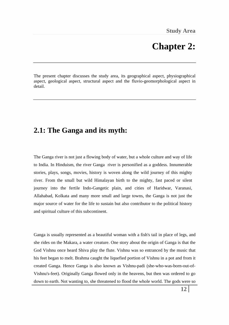
The present work is the comprehensive study of the fluvio-geomorphology of the Ganga
river flowing through the two selected reaches within the Uttar Pradesh states (which
falls between the 24º to 31º N Latitude and 77º to 85º E Longitude) of India (figure 2.2).
The Two selected reaches along the river course are as listed below:
2.2.1: Upper/Western Gangetic Plain:
The area of almost 3100 sq km, for a stretch of roughly 100 km, which falls in the upper/
western part of the Gangetic alluvial plain with in the state of Uttar Pradesh in India
Study Area
15
Figure 2.2: Location map of study area showing the two selected reaches
Study Area
16
have been selected for the present work. This selected area roughly covers the area
between the 29º 17' 36" to 30º 03' 06” N Latitude and 77º 54' 48” to 78º 16' 13" º E
Longitude. These selected stretch cover the river course between Haridwar city in the
north up to the Bijnor in the south and the flow of the river is almost north-south trending
(Figure 2.2).
2.2.2: Lower/Eastern Gangetic Plain:
Along this reach the river almost flows from west towards east between the two major
cities namely Allahabad in the west and Varanasi in the east. This selected reach for the
present work roughly falls between the 25º 05' 35" to 25º 34' 58" N Latitude and 81º 40'
17” to 83º 02' 27” E Longitude. It covers area of almost 7500 sq km, for a stretch about
200 km, which falls in the lower or the eastern part of the Gangetic alluvial plain with in
the state of Uttar Pradesh in India. Near Allahabad, the Ganga river meet the Yamuna
river and flows downstream towards Varanasi.
2.3: Background of the Study Area:
Various aspects, namely geographical, physiographical, fluvial-geomorphological,
geological and structural, of the Ganga river basin need to be discussed in detail to
understand the fluvio-geomorphological changes taking place in the Ganga river course
and its environs.

Study Area
17
2.3.1: Geographical Aspect:
The River Ganga is approximately 2525 km long and river basin covers an area of
8,61,404 sq km. The east-west length of the Ganga plain is about 1000 km and north-
south width varies from 450 km (western part) to 200 km (eastern part), which covers
about 250,000 km². The Bhagirathi River originates from the Gangotri Glacier, an ice
cave on the slopes of Himalayas situated at 4200 m above mean sea level (figure 2.3).
Figure 2.3: Gaumukh, the mouth of the Gangotri glacier and the head of the
Bhagirathi (Ganga) river
The Bhagirathi river meets the Bhilangana river near the old town of Tehri which is now
submerged under the water of the reservoir formed by the construction of the Tehri dam
at the confluence of both the rivers. The Bhagirathi river further flows down to meet
Alaknanda river and the river downstream from the site of confluence of Bhagirathi and
Alaknanda is named as Ganga (figure 2.4).
Study Area
18
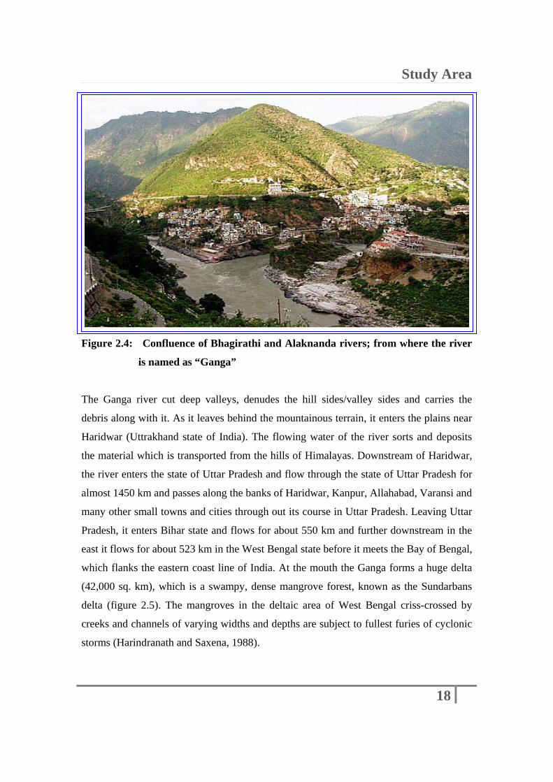
Figure 2.4: Confluence of Bhagirathi and Alaknanda rivers; from where the river
is named as “Ganga”
The Ganga river cut deep valleys, denudes the hill sides/valley sides and carries the
debris along with it. As it leaves behind the mountainous terrain, it enters the plains near
Haridwar (Uttrakhand state of India). The flowing water of the river sorts and deposits
the material which is transported from the hills of Himalayas. Downstream of Haridwar,
the river enters the state of Uttar Pradesh and flow through the state of Uttar Pradesh for
almost 1450 km and passes along the banks of Haridwar, Kanpur, Allahabad, Varansi and
many other small towns and cities through out its course in Uttar Pradesh. Leaving Uttar
Pradesh, it enters Bihar state and flows for about 550 km and further downstream in the
east it flows for about 523 km in the West Bengal state before it meets the Bay of Bengal,
which flanks the eastern coast line of India. At the mouth the Ganga forms a huge delta
(42,000 sq. km), which is a swampy, dense mangrove forest, known as the Sundarbans
delta (figure 2.5). The mangroves in the deltaic area of West Bengal criss-crossed by
creeks and channels of varying widths and depths are subject to fullest furies of cyclonic
storms (Harindranath and Saxena, 1988).

Study Area
19
Figure 2.5: Satellite image showing the Ganges delta
2.3.2: Physiographical Aspect:
Physiographically, the Gangetic plains are one of the three major physiographic units of
the Indian subcontinent. It is bounded by high-lands on northern (Oldham, 1917) and
southern extremes. Towards north, sediments terminates along the Siwalik Hills of
Himalayas and in south the blanket of alluvium tappers out to rest over the peninsular
craton of Vindhyans and hilly tracts of Precambrian Bundelkhand granites. The basin is
bounded on the north by the Himalayas, on the west by the Aravallis as well as the Delhi
ridge separating it from Indus basin, on the south by the Vindhyas and the Chhotanagpur
Plateau also know as peninsular craton and on the east by the Rajmahal Hills and
Brahmaputra ridge.

Study Area
20
2.3.3: Fluvio-Geomorphological Aspect:
The understanding about the inter-relationship between geomorphic landforms and
fluvial processes, can provide clues to infer causes for the dynamic behavior of rivers.
Fluvio-sedimentary processes shape the landform present in the river basin as it carries
out the geological work on the land surface to make them evolve through the time.
This process mainly involve erosion, transportation of terrigenous clastic material, its
sorting and deposition at different places all along the river valley, from head to mouth
of the river. Erosional and depositional processes play an important role in shaping the
Himalayan landscape as well as the Gangetic alluvial plain. The processes of
degradation (erosion), aggradation (deposition) and siltation in the river valley, which
mainly depends on the profile of the terrain, relief of the surface, amount of discharge
and sediment load, gives rise to different fluvio-geomorphological landforms like the
alluvial plain, flood plain, alluvial fans, river course exhibiting meandering, braiding
and anastomosing/anabranching pattern, etc.
The Ganga basin is a part of the composite Ganga-Brahmputra-Meghna basin. The basin
lies in China, Nepal, India and Bangladesh and drains an area of 10,86,000 sq km. It
shows braided and anastomosing drainage patterns and even straight course at places in
the upper Gangetic plain. While in the lower Gangetic plain, it exhibits typical
meandering drainage pattern between Allahabad and Varanasi. The catchment of the
Ganga river basin (Figure 2.6) lies in the states of Uttar Pradesh (2,94,364 sq km),
Madhya Pradesh (1,98,962 sq km), Bihar (1,43,961 sq km), Rajasthan (1,12,490 sq km),
West Bengal (71,485 sq km), Haryana (34,341 sq km), Himachal Pradesh (4,317 sq km)
and Delhi (1,484 sq km). The important tributaries are the Yamuna, the Pandu, the
Ramaganga, the Gomati, the Ghaghara, the Son, the Gandak, the Burhi Gandak, the
Damodar, the Punpun, the Kosi and the Savon and the Mahananda. But only two main
tributaries meet the Ganga river in Uttar Pradesh, i.e. the Ramganga downstream of
Fatehgarh and the Yamuna river exactly near the city of Allahabad. All the other

Study Area
21
tributaries assemble with the Ganga river much downstream, far east in the plain of Bihar
(Figure 2.6). River courses/channels run practically parallel to the Ganga.
Figure 2.6: Basin boundary of the Ganga river and all the major tributaries
Source: http://gfcc.bih.nic.in/
The river Ganga contributes nearly 25 per cent and 2 per cent of the total discharge of
water by all the river systems of India and all the river systems of the world, respectively.
The annual mean discharge of the Ganga is 468.7 billion m³, which is slightly less than
the river Brahmaputra. Singh et al. (2007) studied sediment characteristics and
transportation dynamics of the Ganga river. Transportation dynamics of the sediment
load was assessed by means of channel hydrology, flow/sediment rating curves, bedform
mechanics, grainsize and cumulative curves. It is also stated that the Ganga river
mobilizes a total of 729 x 10 tons of sediments annually through a narrow zone within its
river valley. It is the third largest river of the world after the Yellow and the Amazon
rivers, as far as transporting sediment is concerned.
Study Area
Study Area
22
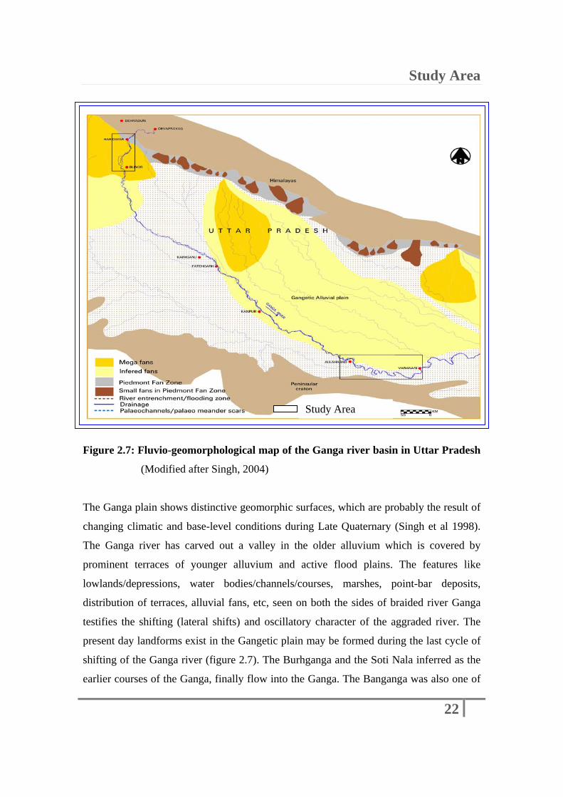
Figure 2.7: Fluvio-geomorphological map of the Ganga river basin in Uttar Pradesh
(Modified after Singh, 2004)
The Ganga plain shows distinctive geomorphic surfaces, which are probably the result of
changing climatic and base-level conditions during Late Quaternary (Singh et al 1998).
The Ganga river has carved out a valley in the older alluvium which is covered by
prominent terraces of younger alluvium and active flood plains. The features like
lowlands/depressions, water bodies/channels/courses, marshes, point-bar deposits,
distribution of terraces, alluvial fans, etc, seen on both the sides of braided river Ganga
testifies the shifting (lateral shifts) and oscillatory character of the aggraded river. The
present day landforms exist in the Gangetic plain may be formed during the last cycle of
shifting of the Ganga river (figure 2.7). The Burhganga and the Soti Nala inferred as the
earlier courses of the Ganga, finally flow into the Ganga. The Banganga was also one of
Study Area

Study Area
23
the old courses of the Ganga in the past (before 1910). These old channel courses in the
northern portion indicate the lateral eastward shifting of the Ganga in recent past. At
some places, westward shift was also noticed. The comparative study using aerial
photographs (1964) and the Survey of India maps (1914) indicated that the river shifted
to the west of the earlier course (before 1914) and it was again shifted to east from 1914
position (Das Gupta, 1975) in the upper Gangetic plain. Similarly the Yamuna river has
also moved eastward 10 km near Kiraoli to 40 km at Kaman (Bakliwal and Sharma,
1980). While in the lower Gangetic plain the river has shifted towards south in recent
past. Because of the rapid growth of the megafans deposited by the Ganga, the drainage
seems to have pushed them southwards (Figure 2.7) and at present the Ganga drainage is
almost 200 to 300 km away from the Himalayan mountain front (Valdiya, 2010,
Burbank, 1992). Philip (1994) studied geomorphic evolution of a part of middle Ganga
plain covering Bihar using Landsat images. It was stated that the river Ganga has been
shifted about 20 km from north to south. The southward migration of the Yamuna river in
the Kalpi area also took place during the time of the active tectonism (Valdiya, 2010,
Singh et al. 1997), or when there was greater discharge in the river following
intensification of monsoon 6,000 to 8,000 years BP (Valdiya, 2010; Tandon et al. 2003).
2.3.4: Geological Aspect:
The geological setup of the area near Rhishikesh/Haridwar section, is characterized by
the Siwalik group of rocks, belonging to the Early to Middle Pleistocene age and from
this onwards, rest of the plains are covered by the alluvium of Quaternary age (Faruqi et
al., 1992). The Gangetic basin comprised alluvium of Quaternary age (Mukerji, 1963;
Singh and Bajpai, 1989; Sarkar, 1995; Khan and Bhartiya, 1995; Pascoe, 1973).
Stratigraphically, the Gangetic alluvial formation belongs to Pleistocene-Holocene
(Quaternary) age and rest unconformably over the Bundelkhand granite-gneiss complex
(Basement or Fundamental complex)/Bijawars, Delhi, Aravali and Vindhyans (Sastri et
Study Area
24
al. 1971). From the palynological and archaeobiological studies, it was found that during
Holocene the brakish water conditions with tidal influence gradually changed to
lacustrine conditions and ultimately to alluvial plain (Gupta, 1992). Kumar (1994) and
Verma (1994) carried out geological investigations on the east and west of the Ganga
river basin, respectively. Sediments, deposited on the banks of the river, consist of
pebbles, at places boulders, coarse to medium to fine sands, loam, clay and their
combinations such as sandy loam, silty clay, etc. The subsurface alluvial succession of
topmost 500m shows two predominant granular sandy zones, inter-layered with three
distinctive clay zones in the central Ganga plain comprising major part of Uttar Pradesh
(Khanna, 1992). The fluvial sequence menifasts several hiatuses in the sedimentation
record represented by palaeosol units (sinha et al. 2002). The average rate of
sedimentation (rate of accretion) derived from the southern part of the central alluvial
plain is 20.4 cm/100 years (Rajagopalan, 1992). In the upper Gangetic plain the alluvial
fan deposits mainly consist of the coarse sediments, including the pebbles and boulders
embedded in the fine sand (Ghosh, 1994). The boulders mainly derived from the side
slopes of the hills because of the river erosion and landslides as well. Number of
rockslides and landslides are present along the Ganga river course from Devprayag to
Haridwar, where as in the lower Gangetic plains the river bed consists of sand deposits
and the flood plains and terraces are made up of sand, silt and clay grade sediments
(Mahadevan, 2002). More over in the central part, larger river that had longer
residence time in their channels built multistory sand bodies, while the
interfluves were formed of fine-frained sediments in floodplains (Singh, 1996). The
quaternary alluvium shows three main divisions on the bases of their respective ages as
listed below (figure 2.8)
2.3.4.1: Banda Older Alluvium (Valdiya, 2010) belongs to Late Pliestocene to Middle
Pliestocene, unconformably underlain by Precambrians and comprises hard, compact,
reddish, brownish silt, clay with kankar, red quartzo-feldspathic sand and gravels. At the
base, unconformity is marked by conglomerates, containing clasts of variable
composition.
Study Area
25
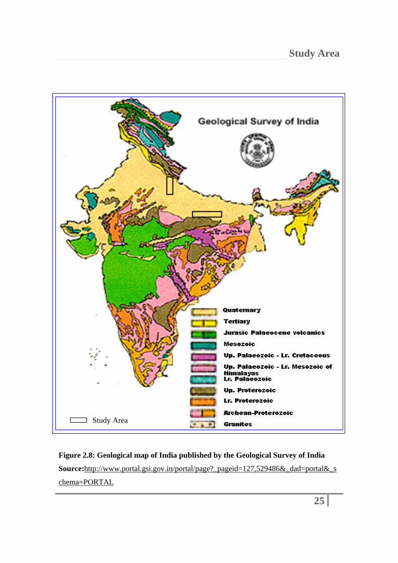
Figure 2.8: Geological map of India published by the Geological Survey of India
Source:http://www.portal.gsi.gov.in/portal/page?_pageid=127,529486&_dad=portal&_s
chema=PORTAL
Study Area
Study Area
26
2.3.4.2: Varansi Older Alluvium (Valdiya, 2010) represents second cycle of deposition
of Quaternary sediments, deposited during Middle Pliestocene to Late Pliestocene, lying
unconformably over the Upper Siwalik formations and Banda Older Alluvium. Thick pile
of yellowish to brownish silt, clay and micaceous sand with intermittent calcrete,
associated with silt-clay deposited as coalesing alluvial fans, the apical part of which near
foot hills contain coarser clastics and distal part becomes finer gradually indicating
fluvial origin.
2.3.4.3: Younger alluvium is recent or Holocene formation, deposited by the youngest
cycle of deposition which is still in the process of formation. Sediments are mainly sand
or silt-clay in nature and it has been further subdivided into different classes. Alluvial fan
deposits and colluvial fan deposits developing over the Varanasi older alluvium having
similar characteristics as later. Terrace alluvium is an older flood plain that has formed
between the present bank and palaeo-banks of the river. Recent alluvium occurs in active
channel in the form of sand bars.
2.3.5: Structural Aspect:
Structurally, the Gangetic plain evolved as a consequence of filling up of a foredeep
basin with vast alluvial fill, on the foreland of the Himalayas, in front of the rising
Siwalik ranges (Valdiya, 2010; Oldham, 1917). Deposition of sediments in the Ganga
plain is related to the episodes of orogenic movements commenced as a result of collision
of the Indian plate with Asian (Eurassian) plate, forming the Himalayan mountain range,
approximately 40 Million years ago. Earlier, the Siwalik foredeep had come in to
exhistance due to the flexing down of the Indian plate following collision of India with

Study Area
27
Asia (Valdiya, 2010; Lyon-Caen and Molnar, 1985). This foredeep was filled with
sediments till late quaternary and once again broke up into two unequal parts along the
Himalayan Frontal Thrust. The northern part evolved as the Siwalik ranges and southern
part became the subsiding Gangetic basin (Valdiya, 1998, 2001), which was filled
predominantly with sediments derived from Himalayas and partly from hills of northern
Peninsula. The Ganga basin exhibits active tectonism, which is mostly in the form of
contractional system in the piedmont zone and prominently extensional system in the
southern part of the basin (Singh, 2004).
The Precambrian and Proterozoic formations are exposed in the Peninsular part of India
and they form the core of the central Himalayas as well. However the surface trace of
Precambrians is not found in the Ganga plain of Uttar Pradesh (Rao, 1973), but it extends
throughout the stretch right from the Peninsular to the Extra Peninsular mountainous
terrain. Aeromagnetic, ground magnetic, gravity and seismic surveys coupled with deep
drilling have shown that the floor of Gangetic basin is very uneven and dissected by
faults (Sastry et al., 1971; Fuloria, 1996). The Gangetic basin comprises large depressions
or “lows” saperated by ridges or “Highs” trending NE-SW in the central sector (Valdiya,
2010). The transverse structures are closely associated with faults of considerable extent
and are the continuation of the structures of the Peninsular India (Valdiya, 2010). It forms
a northerly dipping trough floor fragmented by number of NE-SW and NW-SE trending
system of transverse faults and hence the alluvial deposits are enormously thick in the
northern part and tapers towards south.
The Main Boundary Fault (MBF) exists on the northern edge of the basin. The northern
limit of the piedmont zone is defined by the Himalayan Frontal Thrust (HFT) along
which the Himalaya is being thrust over the alluvium of the Ganga plain (Goswami et al.,
2009). The two major fault plains namely Faizabad high and Monghyr-Sahara, bounded
the central part of the basin. Detailed geomorphic studies by various investigators
(Oldham, 1917; Ahmed, 1963; Sastri et al., 1971; Singh and Bajpai, 1989; Bajpai, 1989)

Study Area
28
using ground data in conjunction with remote sensing data reveal that the
lineaments/faults exist in the Gangetic plain seem to be active in the recent past and at
present. Ahmed (1963) and Singh (1987) studied the neotectonic activities in the
Gangetic plain during Quaternary period. Bajpai (1989) studied the central Gangetic
terrain of Kanpur-Unnao region, U. P., using Landsat images. It was inferred that the
river Ganga is migrating towards south. According to Bajpai (1989) the migration pattern
of the Ganga river indicates the neotectonic subsidence along the longitudinal section of
the river. The presence of various geomorphic features in the Gangetic plain indicates
climatic and tectonic changes in the Late Quaternary. Sastri et al. (1971) and Rao (1973)
have stated that the basement structures below the alluvium of the Gangetic plain in Uttar
Figure 2.9: Structural map of the Ganga river basin in Uttar Pradesh (Modified after
GSI, 1972 and 2000)
Study Area

Study Area
29
Pradesh and Bihar states, namely, Moradabad fault, Bareilly fault, Lucknow Fault and
Patna Fault, respectively, have bearing on the course of the river Ganga. At the junction
of the Siwalik hills and the alluvial Gangetic plain, there are conjugate system of tear
faults extending into the Alluvium, viz. Sharada tear fault system, Gandak tear fault
system, etc. According to Singh and Ghosh (1994) the tear faults have NE-SW and NW-
SE orientation. The surface expressions of these lineaments were distinctly observed on
satellite images. The NW-SE lineaments have control on the fan formation and river
alignment. Verma (1994), stated strong earth movements during Late Holocene period
and neotectonic activity near Main Boundary Fault (MBF) and Foot Hill Fault of the
Himalayas. Philip (1994) has also indicated the influence of fluvial processes and
tectonic activities on the migration of the river Ganga. There are major and minor
lineaments and faults along and across the course of the Ganga river. There are also
subsurface faults present near the course of the river. It was found that the latest
migration of the river Ganga took place in Middle-Late Holocene period. Srivastava and
Singh (1999) found that the river Ganga is shifting mainly in the west and east directions.
These shifting are controlled by sub-surface structures and sediment discharge at some
places. The seismicity of various magnitudes has been noticed along some of these
lineaments/faults in past. These lineaments/faults oriented along NE-SW, NW-SE and W-
E in directions (G.S.I., 1972; G.S.I., 2000) exist in the Gangetic plain (figure 2.9). They
extend from the junction between Alluvium and the Siwalik hills of the Himalayas into
the alluvial Gangetic plain for about several kilometers. NE-SW and NW-SE lineaments
show strike-slip and gravity movements. Some rivers/streams/drainage follow the trend
NW-SE lineaments, particularly north of the Ganga, e.g. Sharda river, Ghaghar river,
Gandak river, etc. Changes in slope due to the tectonic activities like subsidence in the
Gangetic plain cause alteration of drainage and depositional trend. In the central part of
the Gangetic plain, E-W lineaments have a control on the major course of the river
Ganga. In the southern part of the Ganga, rivers follow along SW-NE lineaments. These
lineaments were reactivated during different episodes of the Himalayan orogeny. Fans
developed by the tributaries of Ganga, viz. Sharda, Gandak, etc were skewed due to
neotectonic activities along NW-SE faults in the recent past. Some faults show their
continuity in the Peninsular region also.

Study Area
30
The presence of neotectonic activity along the lineaments is revealed by the studies
carried out using remotely sensed data, geological surveys and deep borehole logs, as no
direct surface manifestations are present. Some of the lineaments control the course of the
river at places. The major movements along the Main Boundary Thrust and reverse faults
genetically related to the northward movement of the Indian plate can be equally
responsible for the changes in the river form.
2.4: Factors affecting river behavior:
Number of factors, individually or together, in different combinations, affect the behavior
of the Ganga river in Uttar Pradesh, to cause the fluvial and geomorphological changes in
the river system, in time and space. These factors can be listed broadly, under two classes
namely:
1. Anthropogenic factors
2. Natural factors
Anthropogenic, includes the human caused factors affecting and bringing the changes in
the natural river system through the activities like the urbanization and development. The
fluvio-geomorphological changes are mainly brought by the construction of engineering
structures, water harvesting and irrigation structures and diversion of river flow by the
construction of embankments.
Natural factors affecting the river behavior are the geographical, physiographical,
geological and structural setting of the river basin. The changes brought by the fluvial
processes like the aggradation, degradation in the river bed and avulsion through the
lateral shifting of the river course. As the amount of discharge changes, the carrying

Study Area
31
capacity of the stream changes, to aggrade or degrade the river bed. Natural factors also
included the structural setting of the river valley, where the faulted and fractured zones
controls the river channel and the tectonic activities bring the abrupt changes in the slope
of the terrain, consequently changing the river morphology.
The channel pattern changes have become known as metamorphoses, defined by
Schumm (1969, 1971) as involving ‘complete transformation’ of river morphology.
Escentially two kinds of pattern changes, in the river morphology, brought by the
natural/anthropogenic agencies, may be distinguished as follows:
1. Autogenic changes, (Allen, 1974) which are ones inherent in the river regime and
involve channel migration, cut-offs, crevassing, avulsion, etc.
2. Allogenic changes, which occur in response to systems changes involving for
instance climatic fluctuations or altered sediment load or discharges, perhaps as a
result of human activity.
Hence autogenic pattern changes are brought by the natural factors, while the allogenic
pattern changes can be the result of both natural as well as anthropogenic factors
affecting individually or together in different combinations. Few of the anthropogenic
and Natural factors affecting Ganga river in the Uttar Pradesh state as studied during the
present study are as discussed below:
2.4.1: Anthropogenic Factors:
Anthropogenic, as the name explains, where the “Anthrōpos” in German means “Man”,
are the factors brought about by human agency. In broad sense the Anthropogenic
factors, effects, processes, objects, or materials are those that are derived from human
activities, as opposed to those occurring in natural environments without human
influences and the sources include industry, agriculture, mining, transportation,
construction, habitations and deforestation.

Study Area
32
River systems are also affected by all the formerly mentioned human activities of urban
development. But most of all the construction of the engineering structures for the
transportation, water harvesting and irrigation and power production, affects the river
morphology severely. Construction of dams and barrages are necessary for irrigation and
hydro power generation and though they are very important and integral part of the
development plans of a country, it also has a prominent impact on the natural ecosystem.
The river’s configuration is remarkably changed by construction of dams and barrages
and these channel pattern changes brought by the anthropogenic factors are solely of
allogenic type.
2.4.2: Natural Factors:
Number of natural factors affect the river behavior and bring the changes in the
morphology of the river. It includes the geographical, geomorphological,
physiographical, geological and structural setting of the river basin as well as the fluvial
processes, which affects the river behavior. These changes are both, the autogenic as well
as the allogenic type.
Alluvial rivers, those that flow between banks and on a bed composed of sediment that is
transported by the river, are sensitive to changes of sediment load, water discharge, and
variations of valley floor slope (Schumm, 1977).
As the amount of discharge changes, the eroding power of the stream as well as the
carrying capacity of the stream is also altered. This altered condition caused by the
change in the amount of discharge and in turn the stream power, affects the processes of
aggradation and erosion along the river bed, changing the channels configuration. The
morphological changes in the channel patter are brought by the fluvial processes like the
aggradation, erosion in the river bed and avulsion through the lateral shifting of the river
course.

Study Area
33
In the longer term, channel patterns may change in response to climatic fluctuations
(Hjulstrom, 1949), as exemplified by Dury in the case of underfit streams (Dury, 1964a
and b, 1965). The amount of water discharge in a stream is affected by the climatic
changes. The streams may also respond to modifications in both water and sediments
discharges (Langford-Smith 1960; Schumm, 1968). Thus change in the sediment load is
also related to the change in the climatic conditions. Monsoon flooding also alters the
channels pattern significantly at times. Patterns have changed as a result of changes in
vegetation (Grant, 1950; Orme and Batley, 1971), following floods (Burkham, 1972;
Schumm and Lichty, 1963). Burkham’s study is extremely instructive concerning the
changes that can occur following floods and floodplain vegetation changes. Channel
avulsion is a common phenomenon triggered by the extreme flooding due to the changed
climatic conditions. Thalweg shifts as well as the development of the new channels are
observed sometimes after the flood recedes.
Alluvial rivers are influenced by changes of valley floor slope, and therefore deformation
of the valley floor by active tectonics can cause pattern change, aggradation, and
degradation (Schumm, 1986). A small change in the slope may lead to a large change in
channel pattern, provided slopes are suitably close to a critical value and with an abrupt
changes are exceeded (Schumm, 1974). Experimental studies of alluvial streams by
Schumm and Khan (1972) suggest that the streams tend to increase in sinuosity with
increase in slope. Thus in high slope conditions river shows meandering pattern and
along the terrain with the low slope the river tends to form braided pattern and river
pattern and form are altered in response to the tectonic activity. Stream patterns are
sensitive indicators of valley-slope change (Schumm, 1972, 1977; Schumm et al., 1972).
Many of the major rivers of the world follow structural lows and major geo-fracture
systems (Potter, 1978). The faulted and fractured zones control the river channel and the
tectonic activities bring the abrupt changes in the slope of the terrain, consequently
changing the river morphology. The high discharge of the rivers should permit them to
maintain their courses in spite of active tectonics (Schumm, 1986). But if the discharge
decreases the structural control becomes more significant over the river morphology.

Study Area
34
Ganga river shows a structural control all through out its course in Uttar Pradesh state.
In spite of the practical significance of active tectonics, only a few investigators have
considered its effects on alluvial rivers (Tator, 1958; Schumm, 1972, 1977; Adams, 1980;
Russ, 1982; Burnett and Schumm, 1983). It is possible that this situation exists because
variations of channel morphology and behavior can also be attributed to downstream
variations of discharge and to the quantity and type of sediment load; therefore, the
effects of active tectonics are difficult to detect (Schumm, 1986).