Chapter 2 Sodium Carbonate Resources of the … 2 Sodium Carbonate Resources of the Eocene Green...
16
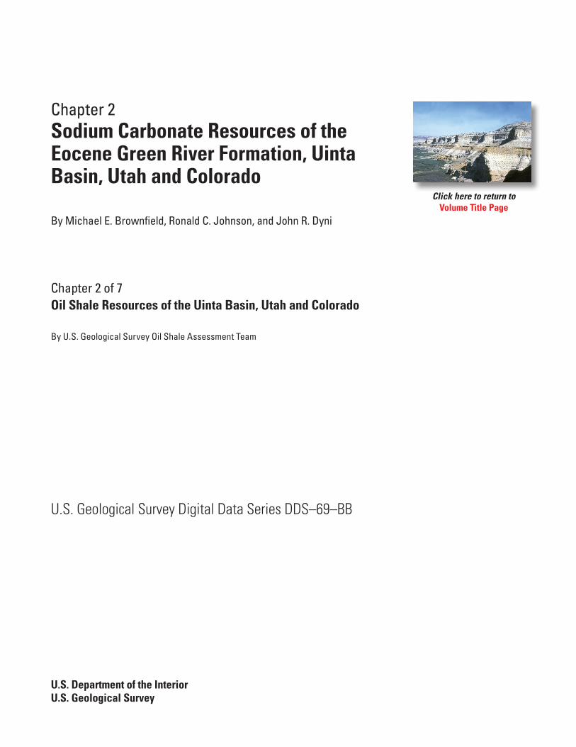
Chapter 2 Sodium Carbonate Resources of the Eocene Green River Formation, Uinta Basin, Utah and Colorado By Michael E. Brownfield, Ronald C. Johnson, and John R. Dyni Chapter 2 of 7 Oil Shale Resources of the Uinta Basin, Utah and Colorado By U.S. Geological Survey Oil Shale Assessment Team U.S. Geological Survey Digital Data Series DDS–69–BB U.S. Department of the Interior U.S. Geological Survey Click here to return to Volume Title Page
Transcript of Chapter 2 Sodium Carbonate Resources of the … 2 Sodium Carbonate Resources of the Eocene Green...
Chapter 2Sodium Carbonate Resources of the Eocene Green River Formation, Uinta Basin, Utah and Colorado
By Michael E. Brownfield, Ronald C. Johnson, and John R. Dyni
Chapter 2 of 7 Oil Shale Resources of the Uinta Basin, Utah and Colorado By U.S. Geological Survey Oil Shale Assessment Team
U.S. Geological Survey Digital Data Series DDS–69–BB
U.S. Department of the InteriorU.S. Geological Survey
Click here to return toVolume Title Page

U.S. Department of the InteriorKEN SALAZAR, Secretary
U.S. Geological SurveyMarcia K. McNutt, Director
U.S. Geological Survey, Reston, Virginia: 2010
For more information on the USGS—the Federal source for science about the Earth, its natural and living resources, natural hazards, and the environment, visit http://www.usgs.gov or call 1-888-ASK-USGS
For an overview of USGS information products, including maps, imagery, and publications, visit http://www.usgs.gov/pubprod
To order this and other USGS information products, visit http://store.usgs.gov
Any use of trade, product, or firm names is for descriptive purposes only and does not imply endorsement by the U.S. Government.
Although this report is in the public domain, permission must be secured from the individual copyright owners to reproduce any copyrighted materials contained within this report.
Suggested citation:Brownfield, M.E., Johnson, R.C., and Dyni, J.R., Sodium carbonate resources of the Eocene Green River Formation, Uinta Basin, Utah and Colorado, 2010: U.S. Geological Survey Digital Data Series DDS–69–BB, chp. 2, 13 p.
iii
Contents
Abstract ...........................................................................................................................................................1Introduction.....................................................................................................................................................1Duchesne Sodium Carbonate and Halite Deposit ....................................................................................1Bird’s-nest Brine Field ...................................................................................................................................5Sodium Carbonate Mineral Resources ....................................................................................................11References Cited..........................................................................................................................................12
Figures
1. Map showing areal distribution of the Eocene Green River Formation in Green River, Piceance, and Uinta Basins, and the locations of five sodium carbonate deposits in Utah, Colorado, and Wyoming ..............................................2
2. Map of Indian Canyon and Duchesne, Utah area showing inferred limits of bedded sodium carbonates and halite in the upper saline facies of the Parachute Creek Member of the Eocene Green River Formation, Uinta Basin, Utah ..........................3
3. Stratigraphic cross section showing saline mineral facies and underlying lacustrine rocks in the upper part of the Eocene Parachute Creek Member of the Eocene Green River Formation near Duchesne, Utah ................................................4
4. Generalized lithologic column showing bedded sodium-carbonate-mineral units in the Marine Minerals CH-2 borehole, Duchesne County, Utah ................................6
5. Drill core containing saline zone units shown in figure 4. Recovered core from the Marine Minerals CH-2 borehole .................................................................................7
6. Drill core containing translucent crystals of eitelite in calcareous marlstone ..................8 7. Drill core containing thin bands of sodium carbonate minerals in
laminated calcareous marlstone ...............................................................................................8 8. Drill core containing small crystals of shortite in laminated calcareous marlstone ........9 9. Drill core containing eitelite and nahcolite crystals in calcareous marlstone ..................9 10. Drill core containing eitelite and nahcolite crystals in calcareous
marlstone .....................................................................................................................................10 11. Map showing locations of selected wells drilled into the Bird’s-nest aquifer
near Bonanza, Utah ....................................................................................................................11
Table
1. Chemical analyses of the Bird’s-nest aquifer waters collected from U.S. Geological Survey core holes Coyote Wash-1 and Red Wash-1 ...............................12

Abstract
The Uinta Basin of northeastern Utah and Colorado contains one known deposit of bedded saline minerals in the Parachute Creek Member of the Eocene Green River Formation near the town of Duchesne, Utah and one sodium-carbonate brine field, the Bird’s-nest zone of the Parachute Creek Member, which is within a confined aquifer in the eastern Uinta Basin near Bonanza, Utah. The Duchesne saline deposit contains eitelite (Na2CO3·MgCO3), nahcolite (NaHCO3), shortite (Na2Ca2(CO3)3), and wegscheiderite (Na5(CO3)(HCO3)3).
The saline mineral deposit at Duchesne contains much smaller quantities of sodium carbonate minerals and is of limited extent when compared to the deposits of nahcolite in the Piceance Basin, Colorado and trona deposits in the Green River Basin, Wyoming. Because the bedded sodium carbonate mineral units at Duchesne are covered by thick overburden, conventional shaft mining would be technically unfeasible. However, if future drilling locates beds of sodium carbonate minerals of sufficient extent, thickness, and richness, they might be recovered by solution mining similar to the mining operation in the Piceance Basin.
Further study in the area of the Bird’s-nest brine field may reveal potential resources of sodium carbonate brines, but dissolved components, such as, chloride, sulfate, and fluoride might pose problems in their development.
Introduction
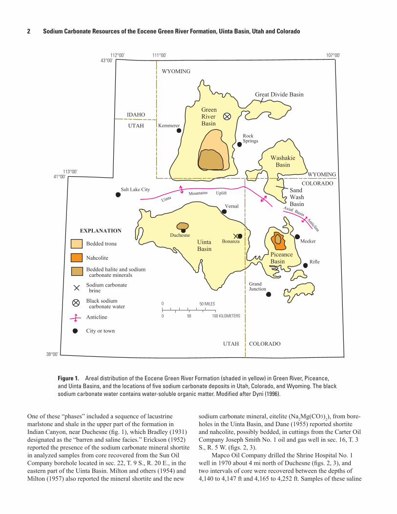
The Eocene Green River Formation contains lacustrine rocks with extensive oil shale beds and saline mineral deposits in parts of the Green River, Piceance, and Uinta Basins in Wyoming, Colorado, and Utah, respectively (fig. 1). The Green River Basin contains the largest known resource of sodium carbonate, consisting of bedded trona (Na2CO3·NaHCO3·2H2O), in southwestern Wyoming (Burnside and Culbertson, 1979; Dyni, 1996, 2005). The Piceance Basin, in northwestern Colorado, contains one of the largest known deposits of sodium bicarbonate, in the form of bedded and nodular nahcolite (NaHCO3) (Brownfield and others, 2010). Several companies currently mine beds of trona
Sodium Carbonate Resources of the Eocene Green River Formation, Uinta Basin, Utah and Colorado
By Michael E. Brownfield, Ronald C. Johnson, and John R. Dyni
underground in Wyoming, and one company solution mines a thick bed of nahcolite in Colorado.
The Eocene Parachute Creek Member of the Green River Formation in the southwestern part of the Uinta Basin, Utah, near the town of Duchesne (fig. 1), consists of oil shale, marlstone, “mealstone,” dolomite, limestone, claystone, shale, siltstone, mudstone, and sandstone. Mealstone is defined as marlstone containing abundant calcite crystal pseudomorphs after shortite (Na2Ca2(CO3)3), which imparts a “mealy” appear-ance to the rock outcrops (Dyni, 1996). The Parachute Creek Member also contains the only deposit of bedded sodium carbonate yet known in the basin (Bradley, 1931; Erickson, 1952; Milton and others, 1954; Dane, 1955; Milton, 1957; Dyni and others, 1985; Dyni, 1996). This deposit near Duch-esne (fig. 1) consists of eitelite (Na2Mg(CO3)2), shortite, and wegscheiderite (Na5(CO3)(HCO3)3). One sodium carbonate brine field has been delineated in the Parachute Creek Mem-ber, the Bird’s-nest zone or Bird’s-nest brine field, which is within a confined aquifer system in the eastern Uinta Basin near Bonanza, Utah (fig. 1).
Duchesne Sodium Carbonate and Halite Deposit
Fluvial and lacustrine rocks in the Parachute Creek Member of the Green River Formation in Indian Canyon near Duchesne contain illite, smectite (stevensite), quartz, sodium and potassium feldspar, calcite, and dolomite with lesser amounts of kaolinite, talc, analcime, and gypsum (Dyni and others, 1985; Dyni, 2002), which are typical components of the Parachute Creek Member. Sodium carbonate minerals, nahcolite, trona, wegscheiderite, eitelite, shortite, and halite have also been identified by many investigators (Milton and others, 1954; Dane, 1955; Milton, 1957; Dyni and others, 1985; Dyni, 1996). The average shale-oil content of the saline mineral-bearing oil shale, measured in gallons per ton (GPT), in the Duchesne area is only about 5 GPT (Dyni, 2002).
Bradley (1931) reported abundant calcite crystal molds of a then-unknown salt in exposures of lacustrine beds of the Green River Formation in the eastern part of the Uinta Basin and in the northern part of the Piceance Creek Basin, resulting in the defining of several “saline phases” within the formation.
2 Sodium Carbonate Resources of the Eocene Green River Formation, Uinta Basin, Utah and Colorado
Salt Lake City
Kemmerer
107°00'111°00'
113°00'
43°00'
38°00'
Rifle
GrandJunction
Anticline
WashakieBasin
GreenRiverBasin
UintaBasin
Duchesne
PiceanceBasin
EXPLANATION
Sodium carbonate brine
SandWashBasin
Bedded halite and sodium carbonate minerals
Bedded trona
Nahcolite
Black sodium carbonate water
41°00'
112°00'
Bonanza
Great Divide Basin
Vernal
RockSprings
Axial Basin
Anticline
Meeker
City or town
0 50 MILES
0 50 100 KILOMETERS
UintaMountains Uplift
IDAHO
WYOMING
WYOMING
COLORADO
COLORADO
UTAH
UTAH
Figure 1. Areal distribution of the Eocene Green River Formation (shaded in yellow) in Green River, Piceance, and Uinta Basins, and the locations of five sodium carbonate deposits in Utah, Colorado, and Wyoming. The black sodium carbonate water contains water-soluble organic matter. Modified after Dyni (1996).
One of these “phases” included a sequence of lacustrine marlstone and shale in the upper part of the formation in Indian Canyon, near Duchesne (fig. 1), which Bradley (1931) designated as the “barren and saline facies.” Erickson (1952) reported the presence of the sodium carbonate mineral shortite in analyzed samples from core recovered from the Sun Oil Company borehole located in sec. 22, T. 9 S., R. 20 E., in the eastern part of the Uinta Basin. Milton and others (1954) and Milton (1957) also reported the mineral shortite and the new
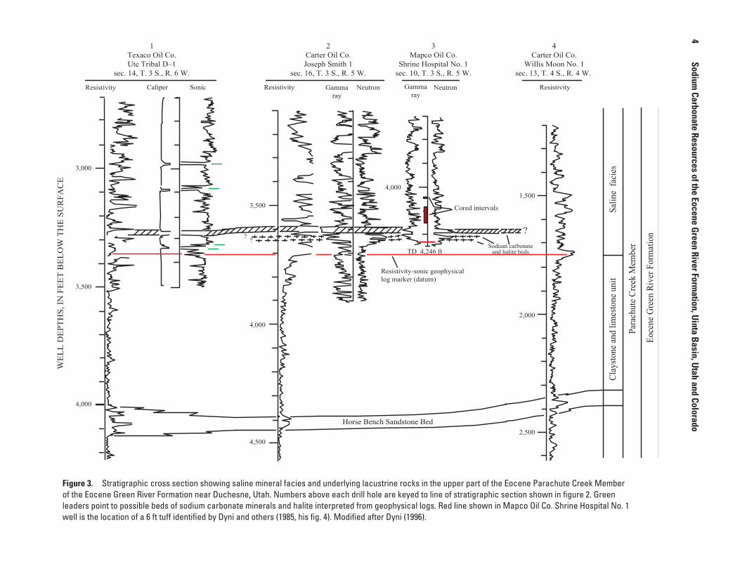
sodium carbonate mineral, eitelite (Na2Mg(CO3)2), from bore-holes in the Uinta Basin, and Dane (1955) reported shortite and nahcolite, possibly bedded, in cuttings from the Carter Oil Company Joseph Smith No. 1 oil and gas well in sec. 16, T. 3 S., R. 5 W. (figs. 2, 3).
Mapco Oil Company drilled the Shrine Hospital No. 1 well in 1970 about 4 mi north of Duchesne (figs. 2, 3), and two intervals of core were recovered between the depths of 4,140 to 4,147 ft and 4,165 to 4,252 ft. Samples of these saline

Duchesne Sodium Carbonate and Halite Deposit 3
40°00'
Duchesne
StrawberryRiver
Left Fork
Right F
ork
SOWERS
CANYON
IndianCanyon
T.2S.
T.3S.
ANTELOPE
CREE
K
T.4S.
T.5S.
R. 3 W.
R. 4 W.R .5 W.R. 6 W.R. 7 W.
Duchesne
River
40°15'
110°30'
110°15'
StarvationReservoir
Sodiumcarbonatespring
Locationmap
Duchesne fault zone
Marine Minerals 2
UTAH
T.6S.
5 MILES0
0 8 KILOMETERS
1,000
1,500
2,000
3,0003,5004,000
4,500
2,500
5,000
5,500
6,000
4,500
6,500
500
1 23
4
Figure 2. Indian Canyon and Duchesne, Utah area showing inferred limits of bedded sodium carbonates and halite in the upper saline facies of the Parachute Creek Member of the Eocene Green River Formation (dashed green line), Uinta Basin, Utah (Dyni, 1996), boreholes (shown as red circles), and line of stratigraphic section (heavy black line) shown on figure 3. Structure contours (shown in red) in feet, drawn with respect to a resistivity-sonic log datum near the base of the saline facies (see fig. 3). Modified after Dyni and others (1985), and Dyni (1996).
4
Sodium Carbonate Resources of the Eocene G
reen River Formation, U
inta Basin, U
tah and Colorado1
Texaco Oil Co.Ute Tribal D–1
sec. 14, T. 3 S., R. 6 W.
2Carter Oil Co.Joseph Smith 1
sec. 16, T. 3 S., R. 5 W.
3Mapco Oil Co.
Shrine Hospital No. 1sec. 10, T. 3 S., R. 5 W.
4Carter Oil Co.
Willis Moon No. 1sec. 13, T. 4 S., R. 4 W.
Para
chut
e Cr
eek
Mem
ber
Salin
e fa
cies
Clay
stone
and
lim
esto
ne u
nit
Eoce
ne G
reen
Riv
er F
orm
atio
n
3,000
4,000
3,500
4,000
4,500
4,000
TD 4,246 ft
Resistivity-sonic geophysicallog marker (datum)
?
1,500
2,000
2,500Horse Bench Sandstone Bed
Resistivity Caliper Sonic Resistivity Gammaray
Neutron Gammaray
Neutron Resistivity
3,500
WEL
L D
EPTH
S, IN
FEE
T B
ELO
W T
HE
SUR
FAC
E
? ?
Cored intervals
Sodium carbonateand halite beds
Figure 3. Stratigraphic cross section showing saline mineral facies and underlying lacustrine rocks in the upper part of the Eocene Parachute Creek Member of the Eocene Green River Formation near Duchesne, Utah. Numbers above each drill hole are keyed to line of stratigraphic section shown in figure 2. Green leaders point to possible beds of sodium carbonate minerals and halite interpreted from geophysical logs. Red line shown in Mapco Oil Co. Shrine Hospital No. 1 well is the location of a 6 ft tuff identified by Dyni and others (1985, his fig. 4). Modified after Dyni (1996).
Bird’s-nest Brine Field 5
beds from the deeper core were collected and analyzed, and consist mostly of halite (60–80 percent) with lesser amounts of wegscheiderite (20–40 percent) and minor amounts of marl-stone (Dyni, 1996). The same cored interval also contained an additional six thin beds containing varied amounts of nahco-lite, northupite (Na3Mg(CO3)2Cl), trona, wegscheiderite, and eitelite interbedded with brown dolomitic marlstone (Dyni and others, 1985). The upper cored interval consisted of brown to gray dolomitic marlstone with no sodium carbonate minerals and halite detected (Dyni and others, 1985).
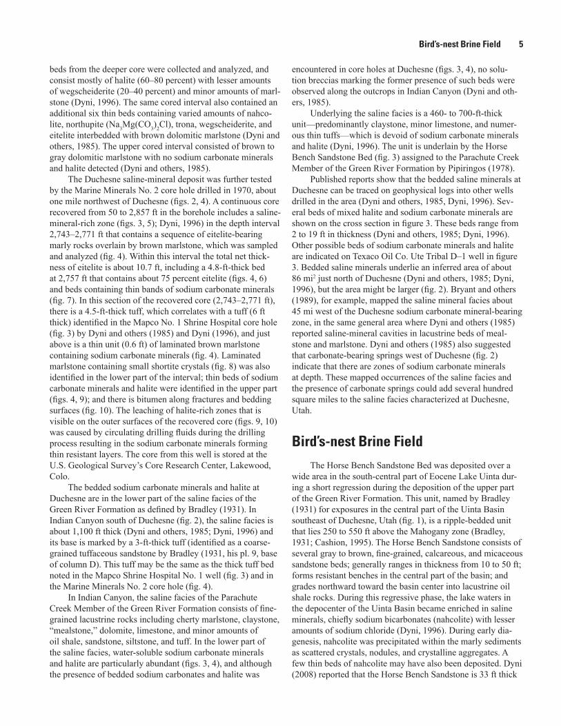
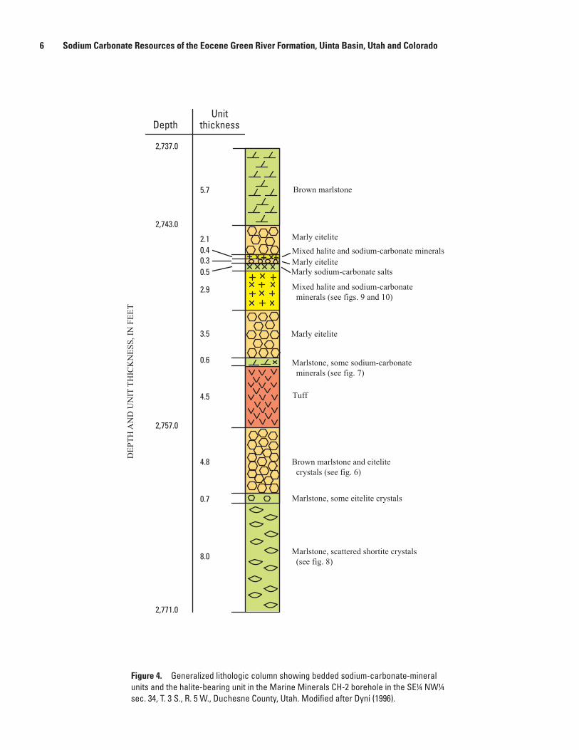
The Duchesne saline-mineral deposit was further tested by the Marine Minerals No. 2 core hole drilled in 1970, about one mile northwest of Duchesne (figs. 2, 4). A continuous core recovered from 50 to 2,857 ft in the borehole includes a saline-mineral-rich zone (figs. 3, 5); Dyni, 1996) in the depth interval 2,743–2,771 ft that contains a sequence of eitelite-bearing marly rocks overlain by brown marlstone, which was sampled and analyzed (fig. 4). Within this interval the total net thick-ness of eitelite is about 10.7 ft, including a 4.8-ft-thick bed at 2,757 ft that contains about 75 percent eitelite (figs. 4, 6) and beds containing thin bands of sodium carbonate minerals (fig. 7). In this section of the recovered core (2,743–2,771 ft), there is a 4.5-ft-thick tuff, which correlates with a tuff (6 ft thick) identified in the Mapco No. 1 Shrine Hospital core hole (fig. 3) by Dyni and others (1985) and Dyni (1996), and just above is a thin unit (0.6 ft) of laminated brown marlstone containing sodium carbonate minerals (fig. 4). Laminated marlstone containing small shortite crystals (fig. 8) was also identified in the lower part of the interval; thin beds of sodium carbonate minerals and halite were identified in the upper part (figs. 4, 9); and there is bitumen along fractures and bedding surfaces (fig. 10). The leaching of halite-rich zones that is visible on the outer surfaces of the recovered core (figs. 9, 10) was caused by circulating drilling fluids during the drilling process resulting in the sodium carbonate minerals forming thin resistant layers. The core from this well is stored at the U.S. Geological Survey’s Core Research Center, Lakewood, Colo.
The bedded sodium carbonate minerals and halite at Duchesne are in the lower part of the saline facies of the Green River Formation as defined by Bradley (1931). In Indian Canyon south of Duchesne (fig. 2), the saline facies is about 1,100 ft thick (Dyni and others, 1985; Dyni, 1996) and its base is marked by a 3-ft-thick tuff (identified as a coarse-grained tuffaceous sandstone by Bradley (1931, his pl. 9, base of column D). This tuff may be the same as the thick tuff bed noted in the Mapco Shrine Hospital No. 1 well (fig. 3) and in the Marine Minerals No. 2 core hole (fig. 4).
In Indian Canyon, the saline facies of the Parachute Creek Member of the Green River Formation consists of fine-grained lacustrine rocks including cherty marlstone, claystone, “mealstone,” dolomite, limestone, and minor amounts of oil shale, sandstone, siltstone, and tuff. In the lower part of the saline facies, water-soluble sodium carbonate minerals and halite are particularly abundant (figs. 3, 4), and although the presence of bedded sodium carbonates and halite was
encountered in core holes at Duchesne (figs. 3, 4), no solu-tion breccias marking the former presence of such beds were observed along the outcrops in Indian Canyon (Dyni and oth-ers, 1985).
Underlying the saline facies is a 460- to 700-ft-thick unit—predominantly claystone, minor limestone, and numer-ous thin tuffs—which is devoid of sodium carbonate minerals and halite (Dyni, 1996). The unit is underlain by the Horse Bench Sandstone Bed (fig. 3) assigned to the Parachute Creek Member of the Green River Formation by Pipiringos (1978).
Published reports show that the bedded saline minerals at Duchesne can be traced on geophysical logs into other wells drilled in the area (Dyni and others, 1985, Dyni, 1996). Sev-eral beds of mixed halite and sodium carbonate minerals are shown on the cross section in figure 3. These beds range from 2 to 19 ft in thickness (Dyni and others, 1985; Dyni, 1996). Other possible beds of sodium carbonate minerals and halite are indicated on Texaco Oil Co. Ute Tribal D–1 well in figure 3. Bedded saline minerals underlie an inferred area of about 86 mi2 just north of Duchesne (Dyni and others, 1985; Dyni, 1996), but the area might be larger (fig. 2). Bryant and others (1989), for example, mapped the saline mineral facies about 45 mi west of the Duchesne sodium carbonate mineral-bearing zone, in the same general area where Dyni and others (1985) reported saline-mineral cavities in lacustrine beds of meal-stone and marlstone. Dyni and others (1985) also suggested that carbonate-bearing springs west of Duchesne (fig. 2) indicate that there are zones of sodium carbonate minerals at depth. These mapped occurrences of the saline facies and the presence of carbonate springs could add several hundred square miles to the saline facies characterized at Duchesne, Utah.
Bird’s-nest Brine Field
The Horse Bench Sandstone Bed was deposited over a wide area in the south-central part of Eocene Lake Uinta dur-ing a short regression during the deposition of the upper part of the Green River Formation. This unit, named by Bradley (1931) for exposures in the central part of the Uinta Basin southeast of Duchesne, Utah (fig. 1), is a ripple-bedded unit that lies 250 to 550 ft above the Mahogany zone (Bradley, 1931; Cashion, 1995). The Horse Bench Sandstone consists of several gray to brown, fine-grained, calcareous, and micaceous sandstone beds; generally ranges in thickness from 10 to 50 ft; forms resistant benches in the central part of the basin; and grades northward toward the basin center into lacustrine oil shale rocks. During this regressive phase, the lake waters in the depocenter of the Uinta Basin became enriched in saline minerals, chiefly sodium bicarbonates (nahcolite) with lesser amounts of sodium chloride (Dyni, 1996). During early dia-genesis, nahcolite was precipitated within the marly sediments as scattered crystals, nodules, and crystalline aggregates. A few thin beds of nahcolite may have also been deposited. Dyni (2008) reported that the Horse Bench Sandstone is 33 ft thick
6 Sodium Carbonate Resources of the Eocene Green River Formation, Uinta Basin, Utah and Colorado
DEP
TH A
ND
UN
IT T
HIC
KN
ESS,
IN F
EET
Brown marlstone5.7
Marly eitelite2.1Mixed halite and sodium-carbonate mineralsMarly eiteliteMarly sodium-carbonate salts
Mixed halite and sodium-carbonate minerals (see figs. 9 and 10)
0.40.30.5
2.9
Marly eitelite3.5
Marlstone, some sodium-carbonate minerals (see fig. 7)
0.6
Tuff4.5
Brown marlstone and eitelite crystals (see fig. 6)
4.8
Marlstone, some eitelite crystals0.7
Marlstone, scattered shortite crystals (see fig. 8)8.0
2,737.0
2,771.0
2,743.0
2,757.0
DepthUnit
thickness
Figure 4. Generalized lithologic column showing bedded sodium-carbonate-mineral units and the halite-bearing unit in the Marine Minerals CH-2 borehole in the SE¼ NW¼ sec. 34, T. 3 S., R. 5 W., Duchesne County, Utah. Modified after Dyni (1996).
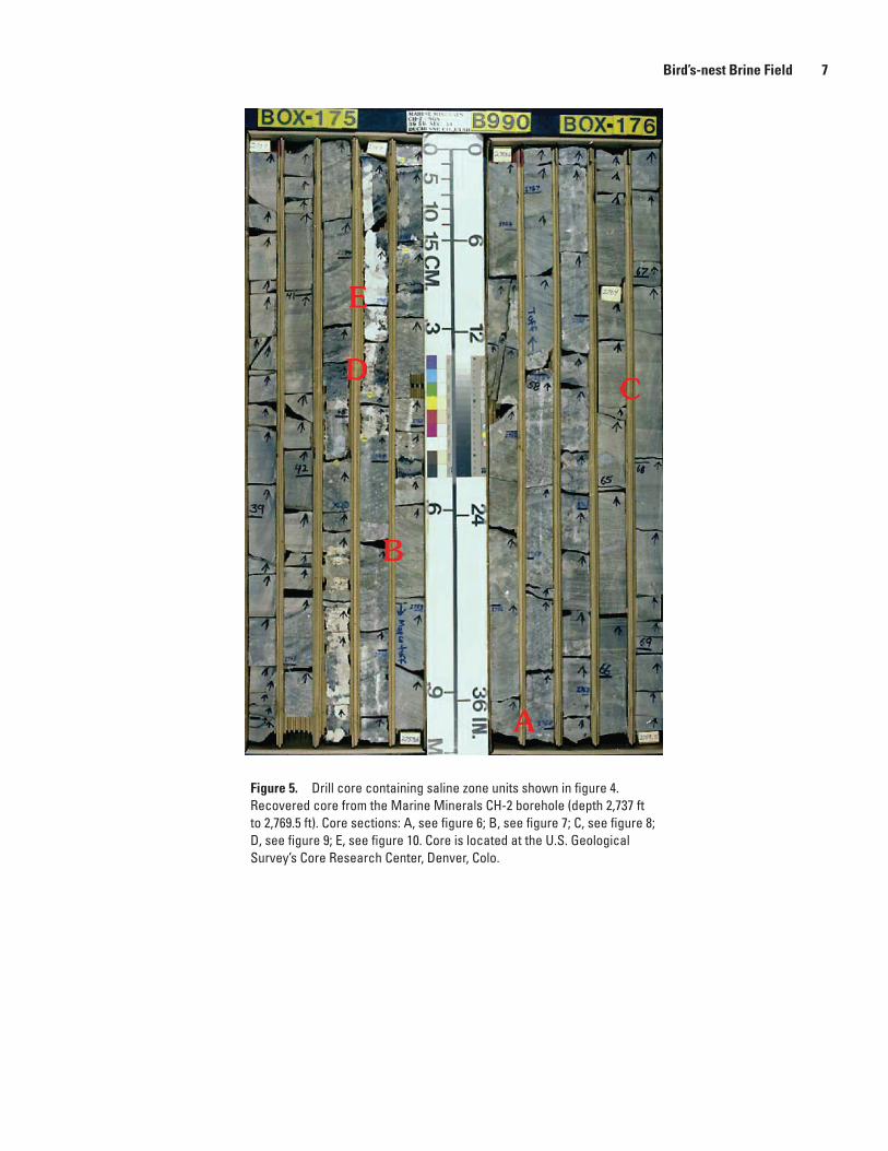
Figure 5. Drill core containing saline zone units shown in figure 4. Recovered core from the Marine Minerals CH-2 borehole (depth 2,737 ft to 2,769.5 ft). Core sections: A, see figure 6; B, see figure 7; C, see figure 8; D, see figure 9; E, see figure 10. Core is located at the U.S. Geological Survey’s Core Research Center, Denver, Colo.
Bird’s-nest Brine Field 7

8 Sodium Carbonate Resources of the Eocene Green River Formation, Uinta Basin, Utah and Colorado
Figure 6. Drill core containing translucent crystals of eitelite in calcareous marlstone. Recovered core from the Marine Minerals CH-2 borehole (depth 2,758.4 ft to 2,759.2 ft). Arrow points to top of borehole. Note dime (0.7 inches in diameter) for scale. Core is located at the U.S. Geological Survey’s Core Research Center, Denver, Colo.
Figure 7. Drill core containing thin bands of sodium carbonate minerals in laminated calcareous marlstone. Recovered core from the Marine Minerals CH-2 borehole (depth 2,752 ft to 2,752.5 ft). Arrow points to top of borehole. Note dime (0.7 inches in diameter) for scale. Core is located at the U.S. Geological Survey’s Core Research Center, Denver, Colo.

Figure 8. Drill core containing small crystals of shortite in laminated calcareous marlstone. Top of borehole towards the left. Recovered core from the Marine Minerals CH-2 borehole (depth 2,767.2 ft to 2,767.8 ft). Arrow points to top of borehole. Note dime (0.7 inches in diameter) for scale. Core is located at the U.S. Geological Survey’s Core Research Center, Denver, Colo.
Figure 9. Drill core containing eitelite and nahcolite crystals in calcareous marlstone. A, Leached core surface from circulating drilling fluids; B, Slabbed surface showing altered minerals (white coating) from sawing process. Recovered core from the Marine Minerals CH-2 borehole (depth 2,745.5 ft to 2,746.2 ft). Arrow points to top of borehole. Note dime (0.7 inches in diameter) for scale. Core is located at the U.S. Geological Survey’s Core Research Center, Denver, Colo.
A
B
Bird’s-nest Brine Field 9
10 Sodium Carbonate Resources of the Eocene Green River Formation, Uinta Basin, Utah and Colorado
A
B
Figure 10. Drill core containing eitelite and nahcolite crystals in calcareous marlstone. A, Leached core surface from circulating drilling fluids; B, Slabbed surface. Recovered core from the Marine Minerals CH-2 borehole (approximately 2,745.5 ft to 2,746.2 ft). Arrow points to top of borehole. Note dime (0.7 inches in diameter) for scale. Core is located at the U.S. Geological Survey’s Core Research Center, Denver, Colo.
and lies 538 ft above the Mahogany bed in Indian Canyon (fig. 2). It can be traced northward into the subsurface on resistivity logs, but it disappears farther to the north toward the depocenter of the Uinta Basin. The Horse Bench Sand-stone appears to be correlative with the “Bird’s-nest zone,” an evaporite facies that crops out in the eastern part of the Uinta Basin.
On outcrop, the Bird’s-nest zone, about 75 ft thick, contains numerous cavities owing to dissolution of the nah-colite (NaHCO3) nodules by surface waters (Cashion, 1967; 1995). Groundwaters caused the dissolution, which resulted in forming a saline-rich aquifer in the upper part of the Green River Formation in an area of at least 250 mi2 in Uinta County (fig. 11), about 30 mi south and east of Vernal, Utah (Lindskov and Kimball, 1984; Dyni, 1996). At this location, the Bird’s-nest zone is approximately 300 ft above the Mahogany zone (Vanden Berg, 2009). The full extent and the lateral continu-ity of the aquifer have not been determined, and outcrops
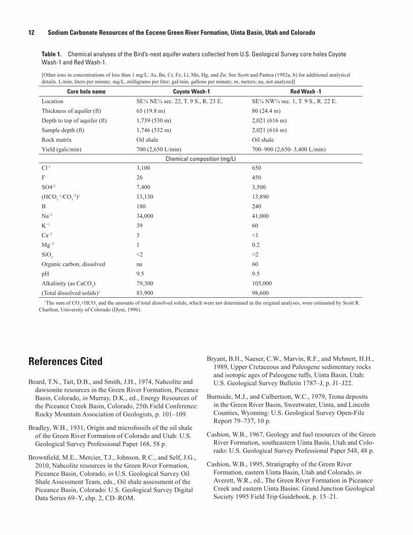
have not been mapped in detail (Vanden Berg, 2008). In the southern part of the area, analyses of waters sampled from wells drilled on Federal lease tracts Ua and Ub indicate that the aquifer is only slightly to moderately saline, ranging from 1,000 to 4,800 mg/L of total dissolved solids (fig. 11). How-ever, much higher salinities were analyzed in the aquifer in two core holes drilled by the U.S. Geological Survey (USGS) northwest of the Federal lease tracts, the Coyote Wash-1 and the Red Wash-1 respectively (fig. 11). Chemical analyses of the saline waters collected from the aquifer are listed in table 1 from Scott and Pantea (1982a, b).
The Bird’s-nest aquifer provides a possible additional means for the disposal of large volumes of saline waters from oil and gas production in the Uinta Basin as current water-disposal wells are reaching capacity (Vanden Berg, 2008, 2009). Research by the Utah Geological Survey indicates that water movement within the aquifer might be controlled by fractures and gilsonite veins creating possible compartments

Sodium Carbonate Mineral Resources 11
R. 22 E. R. 23 E. R. 24 E.
White
River
39°52'30"
40°07'30"109°07'30"109°30'00"
84
99
1.0
1.4
1.41.8
1.92.6
2.82.6
4.8 4.3
3.54.3
Federal oil shaletracts Ua-Ub
Bonanza
T.8S.
T.9S.
T.10S.
Red Wash-1
Coyote Wash-1
0
4
5 MILES
8 KILOMETERS
45
Figure 11. Locations of selected wells drilled into the Bird’s-nest aquifer near Bonanza, Utah. Numbers indicate total dissolved solids in grams/liter (from Lindskov and Kimball, 1984; and Scott and Pantea, 1982a, b). State highway 45 shown in brown. Modified after Dyni (1996).
in the aquifer. Investigation is needed especially to address the possibility that saline-water disposal into the Bird’s-nest aquifer might adversely affect the development of oil shale in the Uinta Basin.
Further study of the Bird’s-nest brine field in the vicin-ity of the USGS Coyote Wash and Red Wash core holes and adjacent areas (fig. 11) may reveal sodium carbonate waters enriched to levels that could potentially be exploited. Dis-solved components in amounts that might cause difficulty in developing this resource include chloride, sulfate, and fluoride (Dyni, 1996).
Sodium Carbonate Mineral Resources
As noted earlier, the Uinta Basin contains at least one known deposit of bedded sodium carbonate minerals (Brad-ley, 1931; Erickson, 1952; Milton and others, 1954; Dane, 1955; Milton, 1957), located near the town of Duchesne, Utah (fig. 1), and one sodium carbonate brine, the Birds-nest
zone, which is within a confined aquifer in the eastern part of the basin near Bonanza, Utah (fig. 1). Sodium carbonate minerals identified in the Parachute Creek Member of the Green River Formation within the Duchesne deposit that may have economic potential are eitelite (Na2CO3·MgCO3), shortite (Na2Ca2(CO3)3) (fig. 6), and wegscheiderite (Na5(CO3)(HCO3)3).
Published data imply that the saline-mineral facies at Duchesne, Utah contain much smaller quantities of sodium carbonate minerals than the deposits of nahcolite in the Piceance Basin, Colorado and the trona deposits in the Green River Basin, Wyoming (Beard and others, 1974; Dyni, 1974; Burnside and Culbertson, 1979; Brownfield and others, 2010). Because the bedded sodium carbonate mineral-bearing units at Duchesne are deep, shaft mining would not appear to be economical. However, if future drilling encounters beds of sodium carbonate minerals of sufficient thickness and rich-ness, they might be recovered by solution mining similar to the mining operation in the Piceance Basin (Brownfield and others, 2010).
12 Sodium Carbonate Resources of the Eocene Green River Formation, Uinta Basin, Utah and Colorado
Table 1. Chemical analyses of the Bird’s-nest aquifer waters collected from U.S. Geological Survey core holes Coyote Wash-1 and Red Wash-1.
[Other ions in concentrations of less than 1 mg/L: As, Ba, Cr, Fe, Li, Mn, Hg, and Zn. See Scott and Pantea (1982a, b) for additional analytical details. L/min, liters per minute; mg/L, milligrams per liter; gal/min, gallons per minute; m, meters; na, not analyzed]
Core hole name Coyote Wash-1 Red Wash -1
Location SE¼ NE¼ sec. 22, T. 9 S., R. 23 E. SE¼ NW¼ sec. 1, T. 9 S., R. 22 E.Thickness of aquifer (ft) 65 (19.8 m) 80 (24.4 m)Depth to top of aquifer (ft) 1,739 (530 m) 2,021 (616 m)Sample depth (ft) 1,746 (532 m) 2,021 (616 m)Rock matrix Oil shale Oil shaleYield (gals/min) 700 (2,650 L/min) 700–900 (2,650–3,400 L/min)
Chemical composition (mg/L)Cl-1 3,100 650F- 26 450SO4-2 7,400 3,500(HCO3
-1/CO3-2)1 13,130 13,890
B 180 240Na+1 34,000 41,000K+1 39 60Ca+2 3 <1Mg+2 1 0.2SiO2 <2 <2Organic carbon, dissolved na 60pH 9.5 9.5Alkalinity (as CaCO3) 79,300 105,000(Total dissolved solids)1 83,900 98,600
1The sum of CO3+HCO3 and the amounts of total dissolved solids, which were not determined in the original analyses, were estimated by Scott R. Charlton, University of Colorado (Dyni, 1996).
References Cited
Beard, T.N., Tait, D.B., and Smith, J.H., 1974, Nahcolite and dawsonite resources in the Green River Formation, Piceance Basin, Colorado, in Murray, D.K., ed., Energy Resources of the Piceance Creek Basin, Colorado, 25th Field Conference: Rocky Mountain Association of Geologists, p. 101–109.
Bradley, W.H., 1931, Origin and microfossils of the oil shale of the Green River Formation of Colorado and Utah: U.S. Geological Survey Professional Paper 168, 58 p.
Brownfield, M.E., Mercier, T.J., Johnson, R.C., and Self, J.G., 2010, Nahcolite resources in the Green River Formation, Piceance Basin, Colorado, in U.S. Geological Survey Oil Shale Assessment Team, eds., Oil shale assessment of the Piceance Basin, Colorado: U.S. Geological Survey Digital Data Series 69–Y, chp. 2, CD–ROM.
Bryant, B.H., Naeser, C.W., Marvin, R.F., and Mehnert, H.H., 1989, Upper Cretaceous and Paleogene sedimentary rocks and isotopic ages of Paleogene tuffs, Uinta Basin, Utah: U.S. Geological Survey Bulletin 1787–J, p. J1–J22.
Burnside, M.J., and Culbertson, W.C., 1979, Trona deposits in the Green River Basin, Sweetwater, Uinta, and Lincoln Counties, Wyoming: U.S. Geological Survey Open-File Report 79–737, 10 p.
Cashion, W.B., 1967, Geology and fuel resources of the Green River Formation, southeastern Uinta Basin, Utah and Colo-rado: U.S. Geological Survey Professional Paper 548, 48 p.
Cashion, W.B., 1995, Stratigraphy of the Green River Formation, eastern Uinta Basin, Utah and Colorado, in Averett, W.R., ed., The Green River Formation in Piceance Creek and eastern Uinta Basins: Grand Junction Geological Society 1995 Field Trip Guidebook, p. 15–21.
References Cited 13
Dane, C.H., 1955, Stratigraphic and facies relationships of the upper part of the Green River Formation and the lower part of the Uinta Formation in Duchesne, Uintah, and Wasatch Counties, Utah: U.S. Geological Survey Chart OC–52.
Dyni, J.R., 1974, Stratigraphy and nahcolite resources of the saline facies of the Green River Formation, Rio Blanco County, Colorado, in Murray, D.K., ed., Energy Resources of the Piceance Creek Basin, Colorado, 25th Field Confer-ence: Rocky Mountain Association of Geologists, p. 111–122.
Dyni, J.R., 1996, Sodium carbonate resources of the Green River Formation: U.S. Geological Survey Open-File Report 96–729, 39 p.
Dyni, J.R., 2002, Lithology, mineralogy, and depositional environments of the upper part of the Green River Formation (Eocene) in Indian Canyon and vicinity, Duchesne County, Utah [abs]: The Geological Society of America, Denver 2002 GSA Annual Meeting, Abstracts with Programs, v. 34, p. 479.
Dyni, J.R., 2005, Geology and resources of some world oil-shale deposits: U.S. Geological Survey Scientific Invest-igations Report 2005–5294, 42 p.
Dyni, J.R., 2008, Preliminary stratigraphic cross sections of oil shale in the Eocene Green River Formation, Uinta Basin, Utah: U.S. Geological Survey Open-File Report 2008–1220, 11 p., 2 plates.
Dyni, J.R., Milton, Charles, and Cashion, W.B., Jr., 1985, The saline facies of the upper part of the Green River Formation near Duchesne, Utah, in Picard, M.D., ed., Geology and Energy Resources, Uinta Basin of Utah: Utah Geological Association, Salt Lake City, p. 51–80.
Erickson, M.P., 1952, New locality of shortite: American Mineralogist, v. 37, p. 342–344.
Lindskov, K.L., and Kimball, B.A., 1984, Water resources and potential hydrologic effects of oil-shale development in the southeastern Uinta Basin, Utah and Colorado: U.S. Geo logical Survey Professional Paper 1307, 32 p.
Milton, Charles, 1957, Authigenic minerals of the Green River Formation of the Uinta Basin, Utah, in Seal, O.G., ed., Guidebook to the Geology of the Uinta Basin, 8th Annual Field Conference: Intermountain Association of Petroleum Geologists, p. 136–143.
Milton, Charles, Axelrod, J.M., and Grimaldi, F.S., 1954, New minerals reedmergnerite (Na2O·B2O3·6SiO2) and eitelite (Na2O·MgO·CO2) associated with leucosphenite, shortite, searlesite, and crocidolite in the Green River Formation, Utah [abs.]: Geological Society of America Bulletin, v. 65, p. 1286–1287.
Pipiringos, G.N., 1978, Preliminary geologic map of the Bates Knolls quadrangle, Uintah County, Utah: U.S. Geological Survey Miscellaneous Field Studies Map, MF–1025, 1 sheet, scale 1:24,000.
Scott, R.W., Jr., and Pantea, M.P., 1982a, Results of USGS oil-shale core drilling in the eastern Uinta Basin: Red Wash-1 drill hole: U.S. Geological Survey Open-File Report 82–965, 38 p.
Scott, R.W., Jr., and Pantea, M.P., 1982b, Results of USGS oil-shale core drilling in the eastern Uinta Basin: Coyote Wash-1 drill hole: U.S. Geological Survey Open-File Report 82–966, 58 p.
Vanden Berg, M.D., 2008, Water-related issues affecting conventional oil and gas recovery and potential oil develop-ment in the Uinta Basin, Utah: Technology Status Assess-ment, U.S. Department of Energy, National Energy Technol-ogy Laboratory, 4 p.
Vanden Berg, M.D., 2009, Understanding the Bird’s-Nest aquifer in Uintah County, Utah–A potential source for large-scale saline water disposal [abs.]: Water/Energy Sustainability Symposium, Groundwater Protection Council Annual Forum, 2009, Salt Lake City, Utah.
Click here to return toVolume Title Page