CHAPTER 2: GEOMORPHOLOGY - Shodhgangashodhganga.inflibnet.ac.in/bitstream/10603/8896/8/08_chapter...
10
GEOMORPHOLOGY CHAPTER 2:
Transcript of CHAPTER 2: GEOMORPHOLOGY - Shodhgangashodhganga.inflibnet.ac.in/bitstream/10603/8896/8/08_chapter...

GEOMORPHOLOGY CHAPTER 2:
Chapter 2: Geomorphology
Page | 19
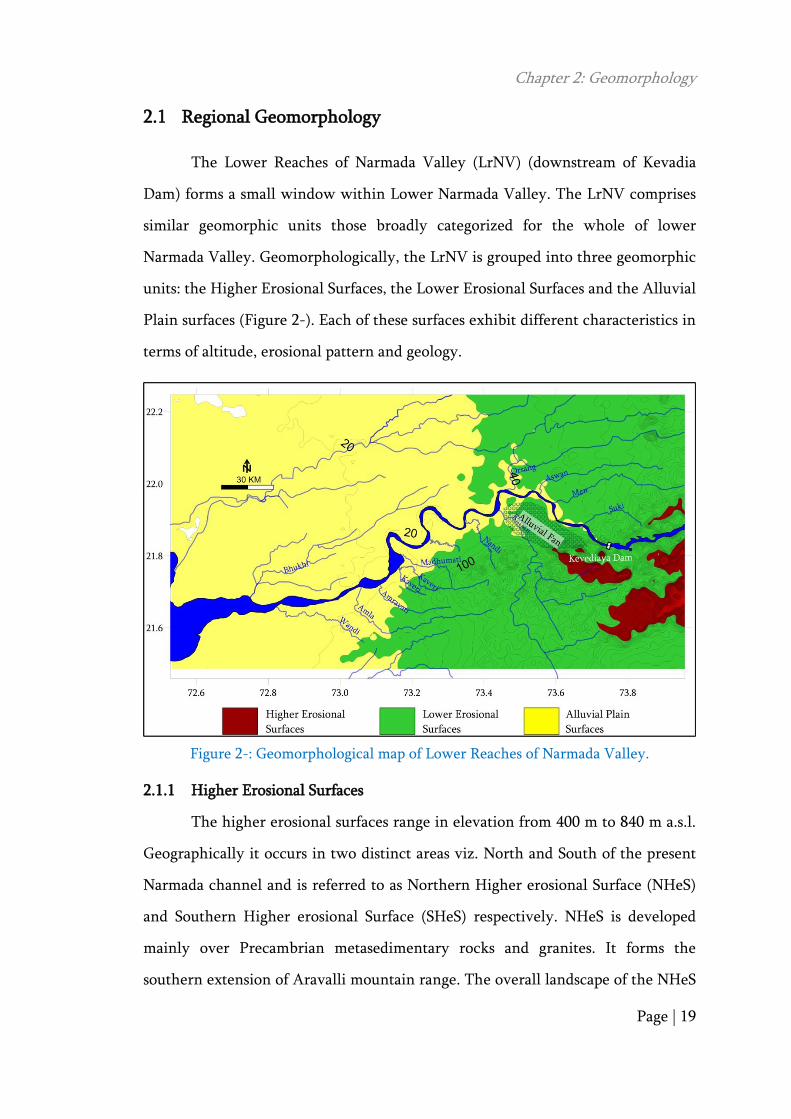
Regional Geomorphology 2.1
The Lower Reaches of Narmada Valley (LrNV) (downstream of Kevadia
Dam) forms a small window within Lower Narmada Valley. The LrNV comprises
similar geomorphic units those broadly categorized for the whole of lower
Narmada Valley. Geomorphologically, the LrNV is grouped into three geomorphic
units: the Higher Erosional Surfaces, the Lower Erosional Surfaces and the Alluvial
Plain surfaces (Figure 2-). Each of these surfaces exhibit different characteristics in
terms of altitude, erosional pattern and geology.
Figure 2-: Geomorphological map of Lower Reaches of Narmada Valley.
2.1.1 Higher Erosional Surfaces
The higher erosional surfaces range in elevation from 400 m to 840 m a.s.l.
Geographically it occurs in two distinct areas viz. North and South of the present
Narmada channel and is referred to as Northern Higher erosional Surface (NHeS)
and Southern Higher erosional Surface (SHeS) respectively. NHeS is developed
mainly over Precambrian metasedimentary rocks and granites. It forms the
southern extension of Aravalli mountain range. The overall landscape of the NHeS

Chapter 2: Geomorphology
Page | 20
shows degraded domal hills that are devoid of regolith. The tributaries drains over
this surface follow structural trends of large fold or limb of anticlinorium/
synclinorium and shows differential erosion in its way. The NHeS forms
catchment for major northern tributary of the Narmada is the Orsang that is
having a drainage area of 4079 sq. km.
The SHeS are well exposed in the South of the present Narmada channel,
represents surface above 400 m. The SHeS attains maximum height of about 840 m
along Rajpipla hills. The SHeS forms an extension of Satpura Hill Range in Gujarat.
The SHeS features a number of basalt flows and associated intrusive. The SHeS
has, on an average, about 1 m to 2 m thick regolith capping the hill top. The lower
order and higher order stream within the SHeS flow through steep and deep
valleys. The River Karjan (1489 sq. km drainage area), a tributary of Narmada has
catchment over the SHeS. The SHeS is bounded by Rajpipla escarpment that
extends from Kevadia dam in the west to Rajpardi in the east. The escarpment is
defined as a regional fault (RF2: Sant and Karanth 1993) and has been further
understood to have played a significant role in defining Cambay basin blocks
(southern Ankleshwar block and northern Jambusar-Bharuch block). Kaila (1981)
further identified extension of these regional fault (RF2) into subsurface displacing
Mohorovicic.
2.1.2 Lower Erosional Surfaces
Lower erosional surfaces are developed in forefront of high erosional
surface and thus occur in both north and south of Narmada channel. The lower
erosional surfaces are 50 m to 300 m in elevation. The Northern Lower Erosional
Surface (NLeS) has developed over Deccan basalt and discontinuous patches of
Bagh Beds, sandstone, limestone and shale. Precambrian granites and quartzite
hills occur as regional high. The contact between Precambrians and Bagh beds
show angular unconformity whereas the contact between Bagh beds and Deccan

Chapter 2: Geomorphology
Page | 21
basalt is faulted (Sant and Karanth, 1988). The NLeS is drained by the Rivers
Orsang, Aswan, Men and Suki. These Rivers have, at places, incised deep through
the Bagh Beds and Deccan basalt like Gorge at Suki River near Kevadia.
The Southern Lower Erosional Surface (SLeS) is well developed on the
western margin of the study area over Deccan basalt and Tertiary sediments
whereas SLeS forms a narrow strip between Narmada channel and SHeS
escarpment over alluvial fans (Sant and Karanth, 1993; Chamyal et al., 1994;
Chamyal et al., 1997; Bhandari et al., 2001; Bhandari, 2004a). The Tertiary
sediments are deformed resulting into several domes (Agarwal, 1984) which
standout as regional high like Babaguru hill. The major tributaries drain the west
of SLeS are Madhumati, Kaveri, Amravati, Karjan and Nandi Khadi.
2.1.3 Alluvial Plains
Alluvial plains are developed on the west and the north of the NLeS and
the SLeS. The River Narmada flows along the southern margin of this vast alluvial
plain. The River Narmada has incised about 30 m exposing various sediment facies
belonging to Quaternary period. Quaternary sediments overlie directly over the
Precambrian rocks, Bagh beds, Deccan basalt and Tertiary sediments. The
variability in sediment facies suggests the role of different processes during
Quaternary period.
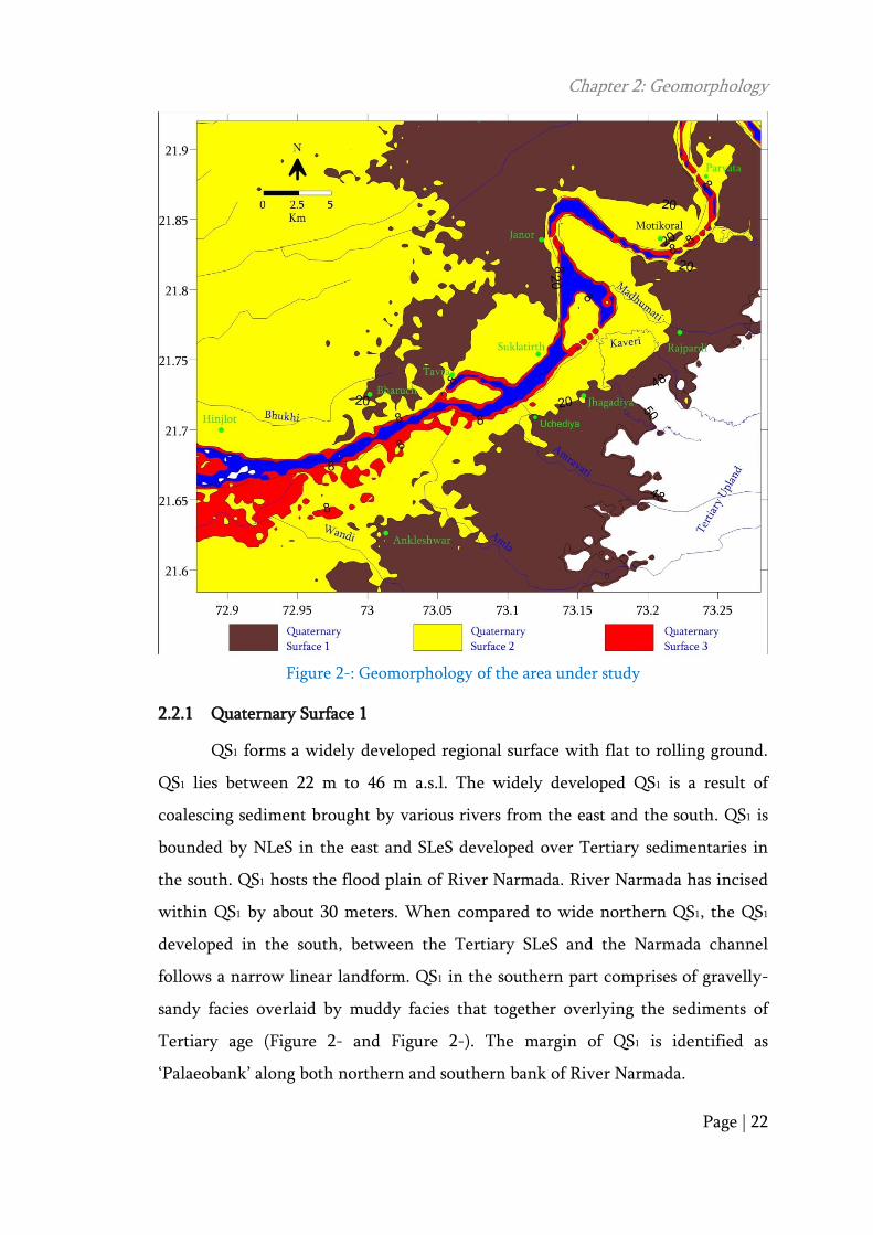
Geomorphology of the Study Area 2.2
The Quaternary landscape of the study area can be distinctly divided into
three geomorphic surfaces, based on the denudational pattern, elevation and linear
to curvilinear erosional boundary. These three surfaces are: Quaternary Surface 1
(QS1) Quaternary Surface 2 (QS2) and Quaternary Surface 3 (QS3) (Figure 2-).
Chapter 2: Geomorphology
Page | 22
Figure 2-: Geomorphology of the area under study
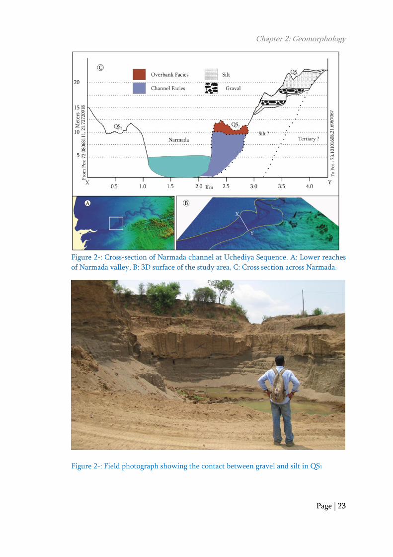
2.2.1 Quaternary Surface 1
QS1 forms a widely developed regional surface with flat to rolling ground.
QS1 lies between 22 m to 46 m a.s.l. The widely developed QS1 is a result of
coalescing sediment brought by various rivers from the east and the south. QS1 is
bounded by NLeS in the east and SLeS developed over Tertiary sedimentaries in
the south. QS1 hosts the flood plain of River Narmada. River Narmada has incised
within QS1 by about 30 meters. When compared to wide northern QS1, the QS1
developed in the south, between the Tertiary SLeS and the Narmada channel
follows a narrow linear landform. QS1 in the southern part comprises of gravelly-
sandy facies overlaid by muddy facies that together overlying the sediments of
Tertiary age (Figure 2- and Figure 2-). The margin of QS1 is identified as
‗Palaeobank‘ along both northern and southern bank of River Narmada.
Chapter 2: Geomorphology
Page | 23
Figure 2-: Cross-section of Narmada channel at Uchediya Sequence. A: Lower reaches
of Narmada valley, B: 3D surface of the study area, C: Cross section across Narmada.
Figure 2-: Field photograph showing the contact between gravel and silt in QS1

Chapter 2: Geomorphology
Page | 24
Along the northern bank of the River Narmada, palaeobank is well
exposed, which follows a curvilinear pattern whereas along the southern bank, the
most prominent landform extending as a linear track running for 65 km is formed.
The palaeobank appears from Rajpardi town, extends towards Ankleshwar and
further west, where it merges with estuary zone. The palaeobank marks lateral
heterogeneity exposing Tertiary rocks closer to Jhagadiya followed by sequence
with gravels at base overlaid by silt. The palaeobanks trends parallel to Cambay
basin marginal fault (RF2, Sant and Karanth, 1993) and several ENE-WSW
trending Plio-Pleistocene anticlines further south (Agrawal, 1984).
2.2.2 Quaternary Surface 2
QS2 represents flood plain of River Narmada. QS2 is bound by palaeobank
along both the northern and the southern bank of the River Narmada. QS2 are
relatively stable but are seasonally active during floods. The elevation of QS2 varies
from 8m to 18m a.s.l. Several tributaries of the River Narmada incised in the SLeS
as well as QS1 get defunct after they flow into QS2, crossing over the palaeobank.
The present Narmada flows on an average 8 m below the QS2 surface,
distinguishing a ‗Neobank‘ (Figure 2-).
Figure 2-: Field photograph of Neobank showing sandy and muddy sequence

Chapter 2: Geomorphology
Page | 25
The neobank developed adjacent to the present Narmada channel, along
both the northern and the southern bank extends for about 45 to 50 km. The QS2
to the north of the present Narmada channel hashave developed in three
discontinuous patches namely, Motikoral Surface, Shuklatirth Surface and Bhukhi
Surface whereas to the south of Narmada QS2 has developed along two patches
namely Uchediya Surface and Parvata Surface. The Uchediya surface forms a
linear, continues and single landform extending for about 35 km aerial distance
with varying width from 0.5 to 6.0 km.
The present study is focused on investigating a very significant landform
developed along the southern bank of the present Narmada River referred to as
Uchediya Surface. Smith et al. (2009), while studying the Peace River of Canada
argued that the geometry of the various Holocene surfaces are the consequence of
accretion and growth of point bars gradually with increase in amplitude of a
meander as well as simultaneous acretion along Counter point bars. However, the
parallel nature of QS1 and QS2 along the southern bank of Narmada show intricate
relationship of landform aggradation.
2.2.3 Quaternary Surface 3
QS3 comprises of active landforms within the channel bounded by
neobanks. The elevation of this landform varies from 2 m to 6 m a.s.l. In the
present study area, QS3 are developed with discontinuity within the channel as
bars (Figure 2-).
The Narmada channel, in the present study area, exposes two significant
channel bars namely Kabirvad bar and Tavara bar developed upstream and
downstream of the village Uchediya respectively. Mapping of bars was carried out
from topographic sheet on 1: 50,000 scales published in 1972 and Satellite image
frame of 2009 incorporated in Google earth. The field observations were
supplemented for updated interpretations. Topographic sheet of 1972 shows, flow
of river water from both the side of the Tavara and Kabirvad bars (Figure 2-)

Chapter 2: Geomorphology
Page | 26
whereas the recent observation in field as well 2009 satellite image frame shows
river flows along a single channel (southern in case of Tavara bar and northern in
case of Kabirvad bar).
Figure 2-: Field photograph showing the develepment of QS3 at downstream of
Uchediya surface.
Figure 2-: Historic modification of Tavra bar and Kabirvad bar between 1972 and 2009
The second channel that once existed is almost blocked by sediment. This
has caused major changes in the thalweg line, initiated erosion along the northern
bank between the Golden Bridge and the National Highway no. 8 Bridge, erosion
along southern bank, near Barbhata village, located opposite to Bharuch city. The
1972 record shows aggradation along the southern bank near Barbhata village. The

Chapter 2: Geomorphology
Page | 27
shift in thalweg line has further initiated development of lateral point bar in
downstream of Golden Bridge (Figure 2-).
Figure 2-: Historic development in QS3 near Bharuch during 1972 to 2009