Chapter 2: A History of Marine Science
41
Chapter 2: A History of Marine Science
Transcript of Chapter 2: A History of Marine Science

Chapter 2:
A History of Marine Science

Guidelines for
Class Discussions and LecturesGoal: Everyone participates!
Approach (for extroverts):
- Please allow two other
students to speak after you
have already made a
comment or asked a
question.
- If you still have
questions/comments, feel
free to write them down
and email them to me.
Approach (for introverts):
- Please try to ask one
question, or make one
comment, in each class.
- You may find it helpful to
think of a question or
comment before class and
bring it with you.

Outline for Today
- Introduction
- Video: Worldwide Voyage of the Hōkūleʻa
- Discussions in Small Groups
- Reports Back

In-Class Activity
• Form 8 groups of 3-4 people.
Please try to form a group that includes at least one person you don’t know yet.
• Each group will discuss one notable person or event related to the exploration
of the ocean.
Refer to your book, the internet (yes, you may use your phones!), or
the slides I’ve emailed you for background information.
• Within your group, please discuss:
1) Who is/was this person or event?
2) Why do you think this is important to the discovery of the ocean?
• Be prepared to present a two-minute summary to your classmates at the
end of class.
• If you’re done early, please write your response to the question below.
OR email me your response by the end of the day tomorrow (Thursday).
• You must respond to this question for course credit:
• How was this person or event different from, OR similar to, the
Worldwide Voyage of the Hōkūleʻa?
(Hint: “They both used boats” is not enough.
BUT one or two sentences is fine.)

History of Human Exploration

American Indians arrived over Bering Land Bridge
(now underwater)

First ocean voyages by Phoenicians (~1200 BC) – primarily economic

Greeks ventured into Atlantic (900-700 BC)

Worldwide Voyage of the Hōkūleʻa
Video: https://vimeo.com/51118047
More Info: http://www.hokulea.com/worldwide-voyage/
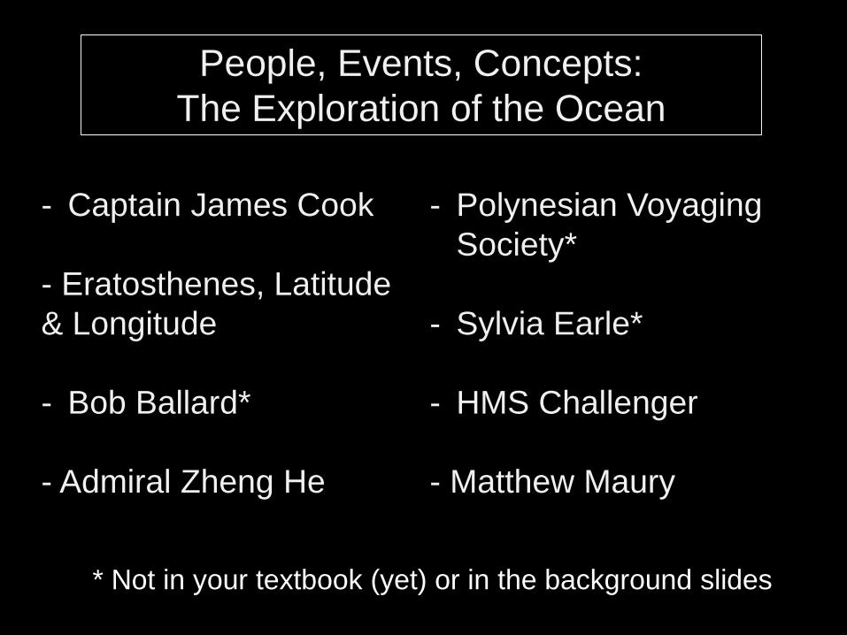
People, Events, Concepts:
The Exploration of the Ocean
- Captain James Cook
- Eratosthenes, Latitude
& Longitude
- Bob Ballard*
- Admiral Zheng He
- Polynesian Voyaging
Society*
- Sylvia Earle*
- HMS Challenger
- Matthew Maury
* Not in your textbook (yet) or in the background slides

Background Slides
for Group Discussions
(roughly organized chronologically)

Eratosthenes (276–194 BC) -
first to accurately determine
Earth’s circumference

Meridians and parallels drawn through important places

Latitude and Longitude on Earth
A simpler idea was to
space meridians and
parallels 1 degree apart.
60 minutes = 1 degree
60 seconds = 1 minute

Latitude and Longitude on Earth
International Date Line


December 8, 1941 December 7, 1941

Celestial Navigation
• How to determine your:
– Latitude
Measure angle (sextant) to North Star
– Longitude
Need a clock

Cartography – making maps for future
navigation
Mercator Projection – means to show 3-D Earth on
2-D map. Greatly exaggerates higher latitudes.

Polynesians were
some of the best
ocean travelers.

Every oceanographic nuance
was utilized:
1) Waves
2) Bird’s flight
3) Ocean smell or temperature
4) Marine life
5) Sunrise/sunset colors
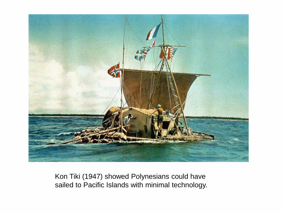
Kon Tiki (1947) showed Polynesians could have
sailed to Pacific Islands with minimal technology.

The Discovery of Hawai‘i: about 1500 years ago
Artwork by Herbert Kawainui Kane
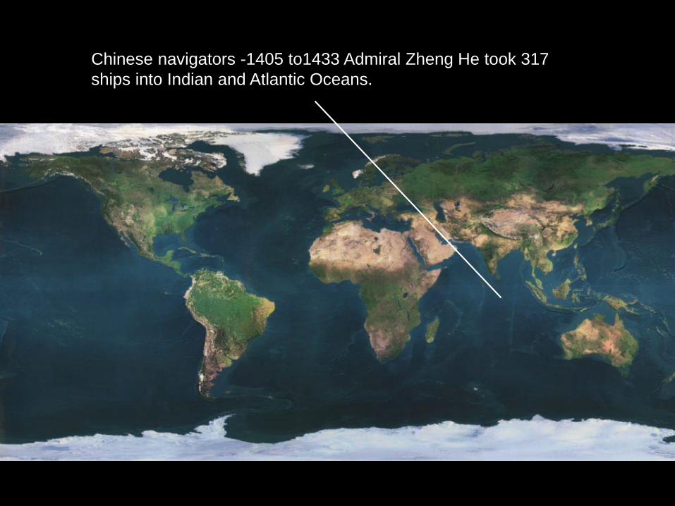
Chinese navigators -1405 to1433 Admiral Zheng He took 317
ships into Indian and Atlantic Oceans.

Non-military, ships loaded
with Ming Dynasty
treasures to be shared.

Chinese invented:
1) Compass
2) Central rudder
3) Watertight compartments
4) Better sails

European navigators -1453, Turks ceased trade to East.

Circa 150

Christopher Columbus tried to find western passage to India.

Voyages of Christopher Columbus

Ferdinand Magellan (1519) –
using revised maps, also
wanted to find western trade
route.

Magellan killed in Philippines, crew went on to
circumnavigate globe. 18 of 260 sailors returned.

Captain James Cook (1768)
left Plymouth on HMS
Endeavor.
Primary mission to show
British dominance
In addition, this was the first
(known) mission to focus on
science.
Charted New Zealand,
mapped Great Barrier Reef.

2 other ships sent out (HMS Resolution and Adventure).
2nd trip – Charted Tonga, Easter Island, circumnavigated
Earth at high latitudes.

3rd trip (HMS Resolution and Discovery)
Charted west coast of North America
1st European to discover Hawai‘i

During Cook’s voyages:
1) Took samples of marine life,
land plants and animals.
2) Sampled ocean floor and
geological formations.

Cook’s Voyages

Matthew Maury (US naval
officer) compiled charts of
ocean currents and winds.
Known as founder of Physical
Oceanography.

HMS Challenger –
first voyage (1872) devoted
100% to oceanography.
First to take complete cores of
deep-sea sediments.
First time ‘oceanography’ used.

To date – longest continuous oceanographic expedition.
One mission - investigate contention that life below 1800ft
impossible.

Discovered 4717 new species at depths of 26,580 feet.