CHAPTER 11 LANDSLIDE - hls.wyo.govhls.wyo.gov/Library/mit_plan/11_Landslide.pdf · CHAPTER 11 ....
14
Wyoming Multi-Hazard Mitigation Plan June 2011 11.1 CHAPTER 11 LANDSLIDE Landslides are one of the most common geologic hazards in Wyoming, with some of the highest landslide densities in the country found within the state. The probability is high that landslide activity will continue to occur into the future in Wyoming. One of the largest landslide complexes in the country is located southwest of Cody in northwestern Wyoming. The Carter Mountain landslide is more than 5 miles wide and 20 miles long. Landslides cause damage every year in Wyoming, but because many occur in remote areas, public awareness of their dangers is low. There are many types of landslides present in Wyoming. In order to properly describe landslide type, the Geologic Hazards Section of the Wyoming State Geological Survey (WSGS) developed a landslide classification modified from Varnes (1978) and Campbell (1985). As can be seen in Figure 11.1 there are five basic types of landslides that occur in three types of material. Falls, topples, slides, lateral spreads, and flows can occur in bedrock, debris, or earth. While individual landslide types can occur in nature, most landslides are complex, or composed of combinations of basic types of landslides. Falls and topples are easy to visualize. In a fall, material detached from a steep slope or cliff descends through the air, and may bounce and roll. In a topple, a mass rotates forward on a pivot point. If a toppling mass pivots far enough, a fall may result. Slides are characterized by shear displacement along one or several surfaces. Two general types of slides are recognized, rotational and translational. In a rotational slide, the surface of rupture is concave upward, and the mass rotates along the concave shear surface. Rotational slides are usually called slumps, and they can occur in bedrock, debris, or earth. In a translational slide, the surface of rupture is a planar or gently undulatory surface. In bedrock and earth, translational slides are usually called block slides if an intact mass slides down the slope. If rock fragments or debris slide down a slope on a distinct shear plane, the movements are called rock slides or debris slides. It is easy to see that confusion can result by applying the term “slide” to all types of landslides. Lateral spreads are characterized by lateral extension movements in a fractured mass. Lateral spread movements may occur in bedrock and soil as a result of liquefaction or plastic flow of subjacent materials, or in bedrock without a well-defined basal shear surface or zone of plastic flow. Lateral spreads in bedrock without a well-defined zone of shearing or flow, usually occur on ridge crests. In general, a flow is a moving mass that has differential internal movements that are distributed throughout the mass. While most flows occur in debris and earth, one type of flow, gravitational sagging, does occur in bedrock. Flows in debris and earth can be cohesive or non-cohesive. Both cohesive and non-cohesive flows are further subdivided by water content and material properties. Cohesive flows in debris include soil creep, solifluction, block streams, talus flows, and rock glaciers. Soil creep is an imperceptibly slow deformation that continues under constant stress. Solifluction is a slow flow in soil that is often observed in areas with perennially or permanently
Transcript of CHAPTER 11 LANDSLIDE - hls.wyo.govhls.wyo.gov/Library/mit_plan/11_Landslide.pdf · CHAPTER 11 ....

Wyoming Multi-Hazard Mitigation Plan June 2011 11.1
CHAPTER 11
LANDSLIDE Landslides are one of the most common geologic hazards in Wyoming, with some of the highest landslide densities in the country found within the state. The probability is high that landslide activity will continue to occur into the future in Wyoming. One of the largest landslide complexes in the country is located southwest of Cody in northwestern Wyoming. The Carter Mountain landslide is more than 5 miles wide and 20 miles long. Landslides cause damage every year in Wyoming, but because many occur in remote areas, public awareness of their dangers is low. There are many types of landslides present in Wyoming. In order to properly describe landslide type, the Geologic Hazards Section of the Wyoming State Geological Survey (WSGS) developed a landslide classification modified from Varnes (1978) and Campbell (1985). As can be seen in Figure 11.1 there are five basic types of landslides that occur in three types of material. Falls, topples, slides, lateral spreads, and flows can occur in bedrock, debris, or earth. While individual landslide types can occur in nature, most landslides are complex, or composed of combinations of basic types of landslides. Falls and topples are easy to visualize. In a fall, material detached from a steep slope or cliff descends through the air, and may bounce and roll. In a topple, a mass rotates forward on a pivot point. If a toppling mass pivots far enough, a fall may result. Slides are characterized by shear displacement along one or several surfaces. Two general types of slides are recognized, rotational and translational. In a rotational slide, the surface of rupture is concave upward, and the mass rotates along the concave shear surface. Rotational slides are usually called slumps, and they can occur in bedrock, debris, or earth. In a translational slide, the surface of rupture is a planar or gently undulatory surface. In bedrock and earth, translational slides are usually called block slides if an intact mass slides down the slope. If rock fragments or debris slide down a slope on a distinct shear plane, the movements are called rock slides or debris slides. It is easy to see that confusion can result by applying the term “slide” to all types of landslides. Lateral spreads are characterized by lateral extension movements in a fractured mass. Lateral spread movements may occur in bedrock and soil as a result of liquefaction or plastic flow of subjacent materials, or in bedrock without a well-defined basal shear surface or zone of plastic flow. Lateral spreads in bedrock without a well-defined zone of shearing or flow, usually occur on ridge crests. In general, a flow is a moving mass that has differential internal movements that are distributed throughout the mass. While most flows occur in debris and earth, one type of flow, gravitational sagging, does occur in bedrock. Flows in debris and earth can be cohesive or non-cohesive. Both cohesive and non-cohesive flows are further subdivided by water content and material properties. Cohesive flows in debris include soil creep, solifluction, block streams, talus flows, and rock glaciers. Soil creep is an imperceptibly slow deformation that continues under constant stress. Solifluction is a slow flow in soil that is often observed in areas with perennially or permanently

Wyoming Multi-Hazard Mitigation Plan June 2011 11.2
frozen ground. Block streams are slow moving tongues of rocky debris on steep slopes, and are often fed by talus cones. Talus flows are slow flows that occur in the basal portions of talus slopes. Rock glaciers are not true landslides, but have been included in the classification scheme because they are mass movements composed of coarse debris. Interstitial ice between debris fragments plays a role in the movement of rock glaciers, which are similar in form to a true glacier. Cohesive flows in earth include soil creep, solifluction, earth flows, and debris laden earth flows. Soil creep and solifluction in earth are similar to those in debris. Earth flows are very slow to rapid flows that have a distinct source area, a main flow track, and a lobate depositional area. Debris laden earth flows are flows that appear to be earth flows but are composed of debris. Standard classifications do not recognize debris laden earth flows, but many have been observed in Wyoming. Many of the landslides present in Wyoming have an earth flow component.
Figure 11.1—Wyoming Landslide Classification. Non-cohesive flows in debris include rock fragment flows and debris flows. Rock fragment flows are extremely rapid flows composed of dry to moist rock debris. This type of flow can be

Wyoming Multi-Hazard Mitigation Plan June 2011 11.3
initiated by a rock fall, by seismic activity, or by other processes. In some cases, it appears that rock debris has moved on a cushion of air, although other mechanisms may have dominated the process. Rock fragment flows can cause significant destruction in a short period of time. Debris flows are a slurry flow composed of debris and a significant amount of water. They are usually associated with unusually heavy precipitation or with rapid snowmelt. Debris flows commonly follow preexisting drainage ways, and commonly form debris levees along their main flow track. Debris flows are a significant component of alluvial fans in mountainous areas with the main debris flow deposit having a broad, fairly flat, fan shape. Debris flows are very common in the mountainous areas of Wyoming. Non-cohesive flows in earth include loess flows, dry sand flows, wet sand flows, rapid earth flows, and mud flows. Loess flows and dry sand flows are rapid to very rapid flows of dry material. Loess flows are usually initiated by seismic activity, and are a fluid suspension of silt in air. Fortunately, none have yet been identified in Wyoming. Dry sand flows usually occur along shorelines or in Aeolian deposits. In Wyoming, most dry sand flows are very small. Wet sand flows occur along river banks or shorelines composed of saturated clean sand. The destabilized sand usually flows into an adjacent body of water. Wet sand flows are not common in Wyoming. Rapid earth flows, also called quick clay flows, are very rapid flows that involve the liquefaction of subjacent material and the entire slide mass. They usually initiate in sensitive materials, such as quick clay, and are not common in Wyoming. Mud flows are slurry flows composed of earth and a significant amount of water. They differ from debris flows only in the size of their component materials. Most landslides mapped in Wyoming are classified as being complex. For example, many landslides in the state are slump/earth flow complexes. That type of landslide is composed of a slump at its head, with the main body and deposit being an earth flow. Block slides often grade into rock slides, which can further grade into earth flows or debris laden earth flows. Such a movement would be classified as a block slide/rock slide/flow complex. History and Distribution The generalized landslide distribution in Wyoming is shown in Figure 11.2. Most of the mapped landslides occur in mountainous areas with levels of precipitation significantly greater than in the state’s basins, as would be expected. Some of the highest landslide densities also occur in areas with active faults exposed at the surface, and in areas with higher levels of seismic activity than the rest of the state. To date, however, very few studies have been done on the relationship between landslides and seismic activity. The WSGS met with personnel from all counties in Wyoming, and reviewed all landslide maps for the counties. In the process, all landslides that presented a potential threat to property, infrastructure, or bodies of water were identified and described. The recent history of landslides in Wyoming is not well defined. There are some notable landslides that have been documented, however. On June 23, 1925, the lower Gros Ventre landslide north of Jackson activated, damming the Gros Ventre River. The landslide mass was a block slide/rock slide/rock fragment/flow complex. Bedrock is dipping towards the Gros Ventre River, with Tensleep Formation sandstones on top of Amsden Formation shales. The sandstones were fairly saturated with water, and the interface

Wyoming Multi-Hazard Mitigation Plan June 2011 11.4
between the sandstones and relatively slippery shales was well lubricated. Small earthquakes may have caused the slope to destabilize, and a large mass of sandstone detached. It moved rapidly downslope, breaking up as it moved. The rapidly moving mass shot across the Gros Ventre River, moved partly up the slope on the opposite valley wall, and settled back into the river, forming a landslide dam and lake. Two years later, on May 18, 1927, the landslide dam partially failed, resulting in flooding and the loss of six lives in Kelly, Wyoming. In July, 1937, landslides in the Big Horn Basin destroyed large sections of railroad tracks and washouts swept away a large number of highway bridges. Railroads and highways were washed out and mining property damaged. Heavy flood damage also occurred in the Big Horn Basin, particularly in the Wind River Canyon and in the vicinity of Shoshoni. The damage in the Wind River Canyon resulted from land slides, which took out several sections of highway and railroad. In all, highways suffered damage in 12 counties. Severe damage occurred in the Upper Big Horn Basin. There were more than 3,000 feet of railway washed out and much covered by landslides. The highway was badly damaged from Riverton to Thermopolis and traffic was suspended temporarily. Near Shoshoni traffic was possible only by long detours. Highways were considerably damaged in ten other counties in the eastern half of the state. In the mid-1980s, a slump/flow complex destabilized at Fossil Butte National Monument in Lincoln County. The landslide moved downslope and destroyed the main rail line of the Union Pacific Railroad over a few hundred feet. The line was closed for a number of days, and all rail traffic that would normally be routed through the area had to be diverted through Colorado. On May 18, 1997, a slump/debris flow complex formed south of Jackson. The debris flow covered and closed U.S. Highway 26/89 through the Snake River Canyon in Teton County. Approximately 300 feet of the highway was covered with up to 15 feet of landslide material. Because of the negative economic impact on the area, the Wyoming Governor declared the area a disaster, and the National Guard was mobilized to help clear the roadway. The road was opened to twice-a-day commuter traffic in three weeks and to full-time traffic in six weeks. On July 18, 2004, a rockslide/debris flow complex closed the east entrance to Yellowstone National Park on U.S. Highway 14/16/20. The landslide, which was within the park boundaries, closed the road through traffic until July 24, 2004. Three vehicles were trapped within the landslide mass, and a fourth was stranded. There was an economic impact on Park County because of the reduction in tourist traffic. There have been a number of other debris flow complexes that have closed U.S. Highway 14/16/20 historically, usually east of Yellowstone National Park. In May 2011, during the writing of this update, a landslide is being experienced on Highway 89 between Afton and Jackson. As in the 1997 landslide described above, the May, 2011 landslide represents an economic hardship for local residents. Residents who live in Afton and work in Jackson are forced to take a 75 mile detour around the landslide into Idaho and over two mountain passes to get to work as Highway 89 is the only direct route between the two towns. At the time of the writing of this plan update the slide is still moving, no monetary losses have been calculated, and problem resolutions are being considered. The Wyoming Department of Transportation (WYDOT) has had recurring problems with landslides in the Bondurant, Hoback Junction, Snake River Highway, Atlantic City, Miller Mountain, Sheridan, Buffalo, Thayne, and Togwotee Pass areas.

Wyoming Multi-Hazard Mitigation Plan June 2011 11.5
Damage caused by landslide activity is typically to highways within the state and is addressed by the Wyoming Department of Transportation. Therefore, local plans include information provided by the state multi-hazard mitigation plan and do not include information addition. Local geology, geologic structure, hydrology, and precipitation are the primary reasons that landslides occur in specific areas. Human activities such as road and highway construction can also have an effect on the occurrence of landslides.
Figure 11.2—Wyoming Landslide Coverage.
Wyoming landslides shown in red http://www.wrds.uwyo.edu/wrds/wsgs/hazards/landslides/lshome.html Accessed 12/20/2010 Wyoming State Geological Survey PO Box 3008 Laramie, WY 82072 (307) 766-2286 x225

Wyoming Multi-Hazard Mitigation Plan June 2011 11.6
Landslide- (Above & Below) US Highway 89 between Afton & Jackson, May 2011

Wyoming Multi-Hazard Mitigation Plan June 2011 11.7
Impacts WYDOT estimates that the approximate yearly cost to remove landslides from roads, maintain landslide-damaged roads, and to study or stabilize landslides is one million dollars per year. Some years have required a larger expenditure of funds. Table 11.1 shows a nine-year total of landslide related expenditures by WYDOT. The total expenditure is $9,830,000.
Reference: Wyoming Department of Transportation.
Future Impacts There are three measures of future landslide impacts—historic dollar damages, estimated yearly damages, and building exposure values. There are not enough current data to estimate historic dollar damages. Estimated yearly damages, as mentioned above, are one million dollars for roads alone. That would equate to $50 million in a 50-year period and $100 million in a 100-year period. For the 2008 plan update the Wyoming State Geological Survey calculated the building exposure value for buildings that may occur in or within 100 feet of mapped landslides. This information was not further researched or updated in the 2010. A potential research project for the next plan update may be to research the intersection of potential landslide areas and areas of development and home construction. All landslides mapped in Wyoming have been digitized (Figure 11.2). The landslides then had a 100-foot buffer digitally added to the outside of their boundary. The modified landslides were then digitally crossed with Census block building values. In some cases, a landslide boundary will dissect a census block. In that case the proportional value of buildings in the census block will be assigned to the landslide. If a census block is within a landslide, then the values of all the buildings in the census block is assigned.
Table 11.1—Yearly Costs of Landslide-Related Activities.
Fiscal year Cost (USD) 1998 8,000,000
1999 396,500
2000 288,900
2001 194,300
2002 157,200
2003 184,300
2004 154,700
2005 237,700
2006 Not available
2007 216,400
2008 347,200
2009 377,100
2010 461,000

Wyoming Multi-Hazard Mitigation Plan June 2011 11.8
The values derived by county are shown in Figure 11.3. Table 11.2 shows the ranking of counties based upon landslide building exposure values.
Although landslides shown in Figure 11.2 have a distinct distribution, the counties do not separate into distinct regions for building exposure values. Table 11.2 does indicate, however, that there are buildings in the state that may be significantly affected by landslides. The total statewide building exposure value for landslides is over $315.3 million.
Table 11.2—Building Exposure Values for Landslides
County Landslide Building
Exposure Value (USD)
Teton 130,857,545 Lincoln 42,785,955 Park 34,169,685 Natrona 32,075,960 Fremont 20,108,960 Sheridan 14,200,885 Sublette 11,385,760 Uinta 7,301,640 Weston 5,650,450 Crook 4,662,910 Big Horn 3,253,820 Albany 1,752,020 Hot Springs 1,580,470 Johnson 1,504,650 Carbon 1,457,610 Campbell 1,358,830 Sweetwater 623,120 Converse 297,930 Washakie 263,295 Platte 31,285 Niobrara 525 Goshen 0 Laramie 0 Total 315,323,305

Wyoming Multi-Hazard Mitigation Plan June 2011 11.9
Figure 11.3—Wyoming Landslide Exposure by County.
The areas where landslides occur are typically in unpopulated areas in western Wyoming. A search for news articles reporting landslides in Wyoming over the past three years resulted in one news story regarding a landslide in populated areas in the past three years. The report documents a landslide occurring in 2010 on a hiking trail in northwest Wyoming. It was reported no injuries or property damage was caused by the landslide. The 2010 landslide occurred as the result of a magnitude 4.6 earthquake in northwest Wyoming. The probability of a landslide occurring in Wyoming is likely. In fact, during the update of this plan a landslide is occurring in the northwest corner of the state. If we can assume what’s happened in the past will continue into the future, the likelihood of damage to roads and infrastructure is high, as the Wyoming Department of Transportation has devoted a portion of their road repair budget to landslide repair over the past decade. That decade’s budget, without the outliers, reflects an average annual landslide repairs costs totaling over $300,000. (See Figure 11.1, page 11.9) The fact a damage-causing landslide is occurring during the writing of this plan would certainly support the likelihood of landslides continuing to cause damage in Wyoming into the future.
Wyoming Multi-Hazard Mitigation Plan June 2011 11.10
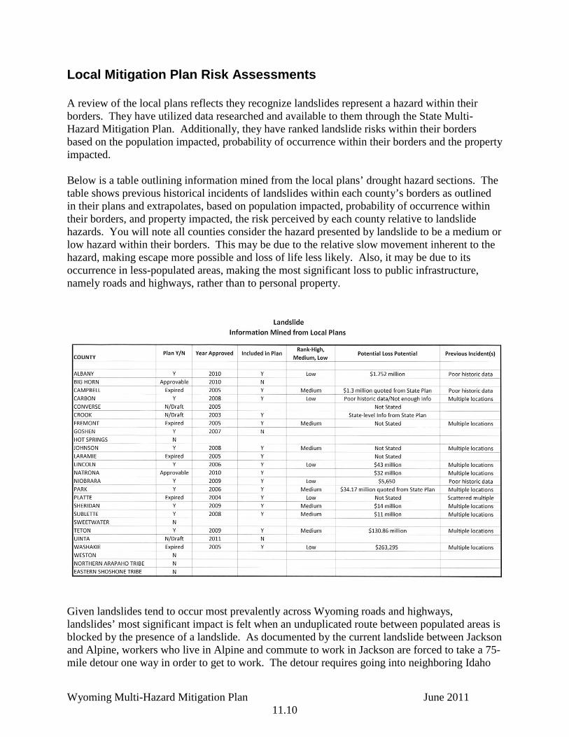
Local Mitigation Plan Risk Assessments A review of the local plans reflects they recognize landslides represent a hazard within their borders. They have utilized data researched and available to them through the State Multi-Hazard Mitigation Plan. Additionally, they have ranked landslide risks within their borders based on the population impacted, probability of occurrence within their borders and the property impacted. Below is a table outlining information mined from the local plans’ drought hazard sections. The table shows previous historical incidents of landslides within each county’s borders as outlined in their plans and extrapolates, based on population impacted, probability of occurrence within their borders, and property impacted, the risk perceived by each county relative to landslide hazards. You will note all counties consider the hazard presented by landslide to be a medium or low hazard within their borders. This may be due to the relative slow movement inherent to the hazard, making escape more possible and loss of life less likely. Also, it may be due to its occurrence in less-populated areas, making the most significant loss to public infrastructure, namely roads and highways, rather than to personal property.
Given landslides tend to occur most prevalently across Wyoming roads and highways, landslides’ most significant impact is felt when an unduplicated route between populated areas is blocked by the presence of a landslide. As documented by the current landslide between Jackson and Alpine, workers who live in Alpine and commute to work in Jackson are forced to take a 75-mile detour one way in order to get to work. The detour requires going into neighboring Idaho

Wyoming Multi-Hazard Mitigation Plan June 2011 11.11
and crossing two mountain passes, then reversing the process to get back to their home, making the commute to work a 125 mile daily excursion. While commuting is not unusual in Wyoming due to the distances between communities, an additional 125 mile per day, landslide-forced commute is significant in an economy where high gas prices impact monthly household budgets. Those traveling between Alpine and Jackson are typically those working in blue collar positions, unable to afford to live in Jackson because of high housing and living expenses. The added costs associated with the longer commute put undue strain on household budgets, making landslide’s potential impact on individual households significant. Albany County’s Multi-Hazard Mitigation plan reflects some areas of landslide risk. Those areas are documented in the map below. You will notice the potential landslide areas are in the western portions of the county, away from populated areas. Albany County is representative of the western counties and counties in northeast portions of the State. Some counties, typically those in the plains regions of the state rather than mountainous topography, reflect little to no risk associated with landslides and do not analyze the risk as a result. Others, like Albany County, do expect landslides to occur within their borders. However, the typical county plan reflects areas where landslides are expected are outside heavily populated areas. Risk is still associated with those areas, however, as landslide areas tend to be picturesque, mountainous locations and therefore attract development. Frequently development in landslide areas consists of vacation and therefore represents a potential risk for injury, loss of life and property.

Wyoming Multi-Hazard Mitigation Plan June 2011 11.12

Wyoming Multi-Hazard Mitigation Plan June 2011 11.13
Proposed State Mitigation Projects The following mitigation projects have been proposed by state, federal, and local entities in the process of generating the Wyoming Multi-Hazard Mitigation Plan. Chapter 22 has all proposed mitigation projects.
• Detailed study of critical and essential facilities and state buildings with exposure to landslides.
• Roadway (including Highway and Interstate) realignment studies, and improved monitoring equipment.
• Monitor select landslides to detect movement. • Study on effect of wildland fire and post-fire precipitation on slope stability. • Education. • Provide all-hazards weather radios to all residences in Wyoming. • Identify and inspect shelters in hazard prone areas. • Research feasibility and costs of adding new frontage roads /detour routes to I-
80, I-90, and I-25 to prevent significant delay in traffic flow and resultant economic loss and possible loss of life.
• Provide hazards info to shelters, emergency facilities in public buildings, campgrounds, and phone books.
• Provide emergency phones at strategic locations with direct lines to emergency dispatch services.
• Develop reseeding plans for losses due to all hazard events. • GIS training for local jurisdictions with emphasis on hazards recognition and
analysis for application to mitigation planning. • Investigate opportunities for developing or improving warning systems as a
means to reduce loss of life, damage to property, and economic losses. • Education programs encompassing multi-hazard insurance for business, resident
and government application. • Education programs encompassing multi-hazard mitigation for business, resident
and government application. • Planning studies regarding transportation of essential and/or key personnel
during all hazard events. • Continue outreach to counties on identifying cost effective and feasible
mitigation projects. • Promote Continuity of Operations and Continuity of Government, statewide. • Maintain and continue to expand hazards databases that were generated for the
State Hazard Mitigation Plan. Seek new sources of information. • Identify, document, and advertise all volunteer agency’s locations and contact
information.

Wyoming Multi-Hazard Mitigation Plan June 2011 11.14
References Cited Campbell, R.H., editor, 1985, Feasibility of a nationwide program for the identification and
delineation of hazards from mud flows and other landslides: U.S. Geological Survey Open File Report 85-276, 58 p.
Varnes, D.J., 1978, Slope movement types and processes, in Schuster, R.L., and Krizek, R.J.,
editors, Landslide analysis and control: National Academy of Sciences, Transportation Research Board, Special Report 176, p. 11-33.