Chapter 10: Water and Sewer Infrastructure - DEIS
9
10-1 Chapter 10: Water and Sewer Infrastructure A. INTRODUCTION This chapter evaluates the potential impacts of the Proposed Project on the City’s water and sewer infrastructure, including the water supply, sanitary wastewater treatment, and stormwater management systems. The Project Site is bounded by the Outerbridge Crossing to the north, the Arthur Kill to the west, the Mill Creek waterway to the south, and Arthur Kill Road to the east. City infrastructure in this area includes water lines and sanitary sewers that are under the jurisdiction of the New York City Department of Environmental Protection (DEP). Treatment of wastewater is provided at the Oakwood Beach Wastewater Treatment Plant (WWTP) which is also operated and maintained by DEP. As described in greater detail in Chapter 1, “Project Description,” the Proposed Project is a commercial center with the associated parking, open space, and street and infrastructure improvements. The proposed new commercial uses would generate new patrons and employees and create new structures that would incrementally increase demands on City infrastructure services. These include water supply, sanitary sewage, and stormwater management services. Therefore, an assessment of these potential impacts on City water and sewer infrastructure is warranted. PRINCIPAL CONCLUSIONS The Proposed Project would not result in any significant adverse impacts related to water and sewer infrastructure. Water demands of the Proposed Project would not overburden the City’s water supply system. Similarly, the added sanitary wastewater treatment demands at the Oakwood Beach WWTP would represent a limited increase in wastewater flow to this plant and would not result in the plant being over overburdened or exceeding its functional capacity. The Project Site is currently almost entirely vacant unbuilt land. With the Proposed Project there would be a stormwater management design that is comprised of extensive green roofs that would be approximately 4.52 acres, a green roof garden, drywells, sand filters, and other stormwater best management practices designed to comply with the New York State Department of Environmental Conservation (NYSDEC) New York State Stormwater Management Design Manual. There would also be a total of four stormwater outfalls to the Arthur Kill, including one new outfall at the end of Richmond Valley Road (to be designed and built to DEP standards and proposed to be part of the City sewer system), and three private outfalls on the commercial property. Once installed, DEP would assume operation of the proposed Richmond Valley Road system and the property owner would operate and maintain the system on the commercial property. The Proposed Project would have no significant adverse impacts on the City’s stormwater management system. Rather, the impacts would be positive as the Proposed Project would be installing a segment of the City’s stormwater drainage system that would serve a larger drainage area. Additionally, the private stormwater management system handling the proposed commercial development would handle drainage internal to the property and would not
Transcript of Chapter 10: Water and Sewer Infrastructure - DEIS

10-1
Chapter 10: Water and Sewer Infrastructure
A. INTRODUCTION
This chapter evaluates the potential impacts of the Proposed Project on the City’s water and sewer infrastructure, including the water supply, sanitary wastewater treatment, and stormwater management systems. The Project Site is bounded by the Outerbridge Crossing to the north, the Arthur Kill to the west, the Mill Creek waterway to the south, and Arthur Kill Road to the east. City infrastructure in this area includes water lines and sanitary sewers that are under the jurisdiction of the New York City Department of Environmental Protection (DEP). Treatment of wastewater is provided at the Oakwood Beach Wastewater Treatment Plant (WWTP) which is also operated and maintained by DEP.
As described in greater detail in Chapter 1, “Project Description,” the Proposed Project is a commercial center with the associated parking, open space, and street and infrastructure improvements. The proposed new commercial uses would generate new patrons and employees and create new structures that would incrementally increase demands on City infrastructure services. These include water supply, sanitary sewage, and stormwater management services. Therefore, an assessment of these potential impacts on City water and sewer infrastructure is warranted.
PRINCIPAL CONCLUSIONS
The Proposed Project would not result in any significant adverse impacts related to water and sewer infrastructure. Water demands of the Proposed Project would not overburden the City’s water supply system. Similarly, the added sanitary wastewater treatment demands at the Oakwood Beach WWTP would represent a limited increase in wastewater flow to this plant and would not result in the plant being over overburdened or exceeding its functional capacity.
The Project Site is currently almost entirely vacant unbuilt land. With the Proposed Project there would be a stormwater management design that is comprised of extensive green roofs that would be approximately 4.52 acres, a green roof garden, drywells, sand filters, and other stormwater best management practices designed to comply with the New York State Department of Environmental Conservation (NYSDEC) New York State Stormwater Management Design Manual. There would also be a total of four stormwater outfalls to the Arthur Kill, including one new outfall at the end of Richmond Valley Road (to be designed and built to DEP standards and proposed to be part of the City sewer system), and three private outfalls on the commercial property. Once installed, DEP would assume operation of the proposed Richmond Valley Road system and the property owner would operate and maintain the system on the commercial property. The Proposed Project would have no significant adverse impacts on the City’s stormwater management system. Rather, the impacts would be positive as the Proposed Project would be installing a segment of the City’s stormwater drainage system that would serve a larger drainage area. Additionally, the private stormwater management system handling the proposed commercial development would handle drainage internal to the property and would not
Riverside Galleria EIS
10-2
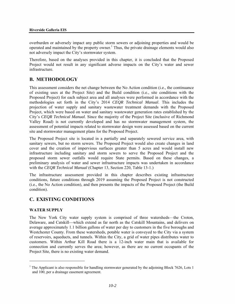
overburden or adversely impact any public storm sewers or adjoining properties and would be operated and maintained by the property owner.1 Thus, the private drainage elements would also not adversely impact the City’s stormwater system.
Therefore, based on the analyses provided in this chapter, it is concluded that the Proposed Project would not result in any significant adverse impacts on the City’s water and sewer infrastructure.
B. METHODOLOGY
This assessment considers the net change between the No Action condition (i.e., the continuance of existing uses at the Project Site) and the Build condition (i.e., site conditions with the Proposed Project) for each subject area and all analyses were performed in accordance with the methodologies set forth in the City’s 2014 CEQR Technical Manual. This includes the projection of water supply and sanitary wastewater treatment demands with the Proposed Project, which were based on water and sanitary wastewater generation rates established by the City’s CEQR Technical Manual. Since the majority of the Project Site (inclusive of Richmond Valley Road) is not currently developed and has no stormwater management system, the assessment of potential impacts related to stormwater design were assessed based on the current site and stormwater management plans for the Proposed Project.
The Proposed Project site is located in a partially and separately sewered service area, with sanitary sewers, but no storm sewers. The Proposed Project would also create changes in land cover and the creation of impervious surfaces greater than 5 acres and would install new infrastructure including sanitary and storm sewers to serve the Proposed Project and the proposed storm sewer outfalls would require State permits. Based on these changes, a preliminary analysis of water and sewer infrastructure impacts was undertaken in accordance with the CEQR Technical Manual (Chapter 13, Section 220, Table 13-1.)
The infrastructure assessment provided in this chapter describes existing infrastructure conditions, future conditions through 2019 assuming the Proposed Project is not constructed (i.e., the No Action condition), and then presents the impacts of the Proposed Project (the Build condition).
C. EXISTING CONDITIONS
WATER SUPPLY
The New York City water supply system is comprised of three watersheds—the Croton, Delaware, and Catskill—which extend as far north as the Catskill Mountains, and delivers on average approximately 1.1 billion gallons of water per day to customers in the five boroughs and Westchester County. From these watersheds, potable water is conveyed to the City via a system of reservoirs, aqueducts, and tunnels. Within the City, a grid of water pipes distributes water to customers. Within Arthur Kill Road there is a 12-inch water main that is available for connection and currently serves the area; however, as there are no current occupants of the Project Site, there is no existing water demand.
1 The Applicant is also responsible for handling stormwater generated by the adjoining Block 7626, Lots 1
and 100, per a drainage easement agreement.

Chapter 10: Water and Sewer Infrastructure
10-3
SANITARY WASTEWATER
The Project Site is located within the service area of the Oakwood Beach WWTP, which treats sanitary wastewater from much of south and west Staten Island and discharges the treated effluent into the Lower Bay. This WWTP provides secondary treatment of wastewater (i.e., 85 percent removal of solids and biological oxygen demand organics) and the treatment capacity of the plant and the effluent is regulated and monitored in accordance with a State Pollutant Discharge Elimination System (SPDES) permit that has been issued by NYSDEC. The Oakwood Beach WWTP is permitted to treat an average flow of approximately 40 mgd. The average flow rate at the plant for the latest 12 months of available DEP records is 26 mgd, which is approximately 65 percent of the treatment capacity of the plant. There is an existing 15-inch sanitary sewer in Arthur Kill Road that conveys the generated wastewater from this part of Staten Island to the WWTP.
STORMWATER
OVERVIEW
Stormwater runoff is the result of rainwater or snowmelt that flows from the surfaces of land or structures. The volume of runoff generated over these surfaces varies depending on permeability factors, which range from pervious (i.e., natural or vegetated surfaces that facilitate percolation to the ground below, generating less runoff), to impervious (i.e., surfaces such as building roofs that do not percolate and just generate runoff). Therefore, a typical vegetated land surface has a low runoff coefficient of about 0.20 (20 percent runoff); in contrast, a building roof has no percolation and, therefore, has a high runoff coefficient of 1.00 (100 percent runoff). Paved areas (e.g., streets and sidewalks) primarily generate runoff, with some percolation to the ground below (a runoff coefficient of 0.85).
CURRENT RUNOFF PATTERNS (PROJECT SITE)
With the exception of the small area occupied by the Cole House and its structures and a partially paved northern access drive, the Project Site is currently vegetated and is predominantly pervious with a low runoff coefficient. Additionally, since the Project Site is largely undeveloped, there is also no formal stormwater collection system. What runoff is generated therefore collects in depressions on the site and percolates to the ground or drains toward the Arthur Kill or Mill Creek via surface flow, where the shoreline along these waterways is the lowest elevation on the Project Site. Wetlands on the site would also be locations where some stormwater runoff collects and infiltrates into the ground.
D. THE FUTURE WITHOUT THE PROPOSED PROJECT
In the future without the Proposed Project, it is assumed that the existing site conditions and runoff patterns would remain unchanged.
E. THE FUTURE WITH THE PROPOSED PROJECT
WATER SUPPLY
For purposes of analysis, the amount of sanitary sewage is estimated to be equal to the entire water demand generated by the Proposed Project except for water used by air conditioning, which is typically not discharged back into to the sewer system. In the future with the Proposed
Riverside Galleria EIS
10-4
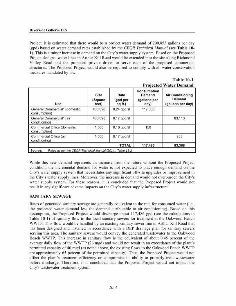
Project, it is estimated that there would be a project water demand of 200,853 gallons per day (gpd) based on water demand rates established by the CEQR Technical Manual (see Table 10-1). This is a minor increase in demand on the City’s water supply system. Based on the Proposed Project designs, water lines in Arthur Kill Road would be extended into the site along Richmond Valley Road and the proposed private drives to serve each of the proposed commercial structures. The Proposed Project would also be required to comply with all water conservation measures mandated by law.
Table 10-1Projected Water Demand
Use
Size (Square
feet)
Rate (gpd per
sq.ft.)
Consumption Demand
(gallons per day)
Air Conditioning Demand
(gallons per day)
General Commercial* (domestic consumption)
488,898 0.24 gpd/sf 117,336
General Commercial* (air conditioning)
488,898 0.17 gpd/sf 83,113
Commercial Office (domestic consumption)
1,500 0.10 gpd/sf 150
Commercial Office (air conditioning)
1,500 0.17 gpd/sf 255
TOTAL 117,486 83,368
Source: Rates as per the CEQR Technical Manual (2014), Table 13-2.
While this new demand represents an increase from the future without the Proposed Project condition, the incremental demand for water is not expected to place enough demand on the City's water supply system that necessitates any significant off-site upgrades or improvement in the City’s water supply lines. Moreover, the increase in demand would not overburden the City's water supply system. For these reasons, it is concluded that the Proposed Project would not result in any significant adverse impacts on the City’s water supply infrastructure.
SANITARY SEWAGE
Rates of generated sanitary sewage are generally equivalent to the rate for consumed water (i.e., the projected water demand less the demand attributable to air conditioning). Based on this assumption, the Proposed Project would discharge about 117,486 gpd (see the calculations in Table 10-1) of sanitary flow to the local sanitary sewers for treatment at the Oakwood Beach WWTP. This flow would be handled by an existing sanitary sewer line in Arthur Kill Road that has been designed and installed in accordance with a DEP drainage plan for sanitary sewers serving this area. The sanitary sewers would convey the generated wastewater to the Oakwood Beach WWTP. This increase in sanitary flow is the equivalent of about 0.45 percent of the average daily flow of the WWTP (26 mgd) and would not result in an exceedance of the plant’s permitted capacity of 40 mgd (as noted above, the existing flows to the Oakwood Beach WWTP are approximately 65 percent of the permitted capacity). Thus, the Proposed Project would not affect the plant’s treatment efficiency or compromise its ability to properly treat wastewater before discharge. Therefore, it is concluded that the Proposed Project would not impact the City's wastewater treatment system.

Chapter 10: Water and Sewer Infrastructure
10-5
STORMWATER
DEP FLOW VOLUME CALCULATION MATRIX
With the Proposed Project, a portion of the Project Site would be developed with the building, private drives, Richmond Valley Road, and waterfront open space. This development would alter the current drainage patterns at the Project Site as new surfaces are introduced. Therefore, the Proposed Project includes a stormwater management plan that would capture and manage all the runoff that it generates (see Figure 10-1). Table 10-2 summarizes the projected changes in runoff characteristics at the Project Site based on the guidelines presented in the City’s CEQR Technical Manual.
Table 10-2Surface Runoff Conditions at the Proposed Project Site
Subcatchment or Receiving Waterbody for Storm Sewer or Direct Discharge (Weighted Runoff Coefficient, C)
Existing Conditions
Surface Type1 Roof2 Pavement &
Walks Other Grass & Soft
Scape Total
Area (%) 0.60 4.89 0 94.51 100
Surface Area, Acres 0.09 0.73 0.00 14.17 14.99
Runoff Coefficient 1.00 0.85 0.85 0.20 0.24
Proposed Conditions
Area (%) 56.17 38.96 1.10 3.78 100
Surface Area, Acres 8.42 5.84 0.16 0.57 14.99
Runoff Coefficient 1.00 0.85 0.85 0.20 0.91
Notes: Calculations for development portion of the site only. All other areas of the Project Site to remain natural or undisturbed (e.g., underwater lands).
1 Runoff coefficients for each surface type are as per the CEQR Technical Manual.
2 Total on-site roof area.
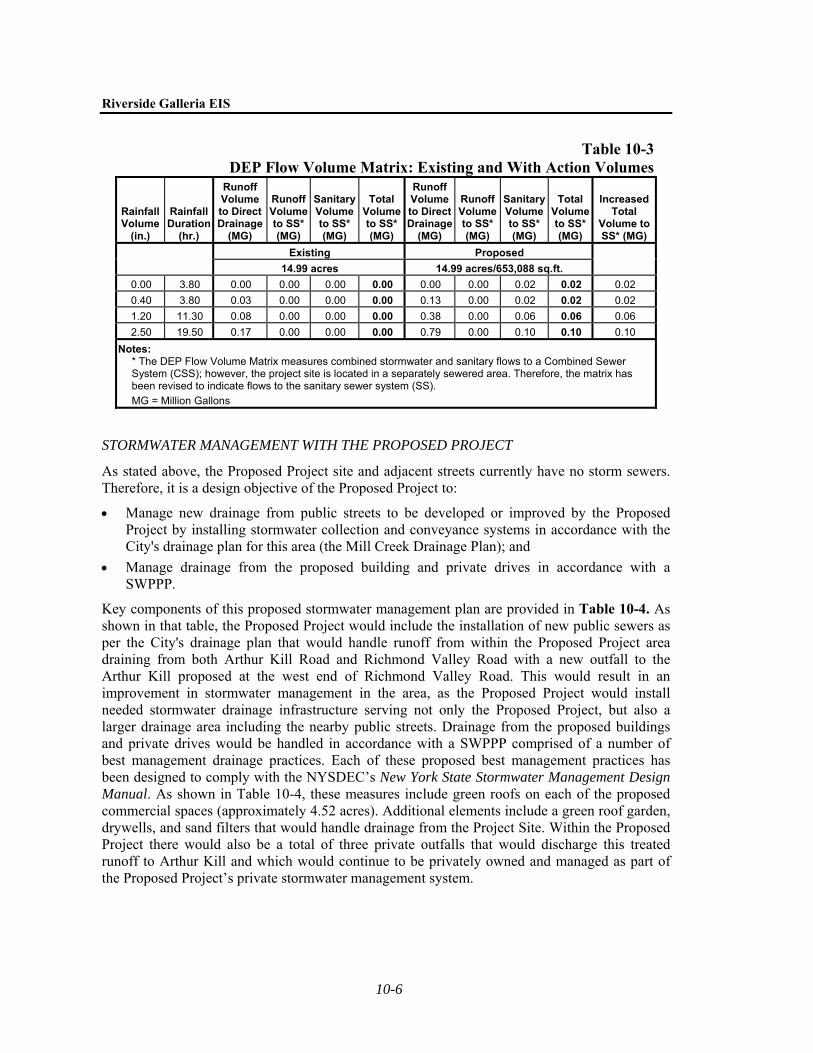
The Flow Volume Calculation Matrix as per the CEQR Technical Manual was also completed to identify potential increases in sanitary wastewater and stormwater runoff volumes with the Proposed Project. These data are provided in Table 10-3.

1.17
.17
Fig
ure
10-
1RI
VERS
IDE
GALL
ERIA
Prop
osed
Sto
rmw
ater
Man
agem
ent P
lan
Riverside Galleria EIS
10-6
Table 10-3DEP Flow Volume Matrix: Existing and With Action Volumes
Rainfall Volume
(in.)
Rainfall Duration
(hr.)
Runoff Volume to Direct Drainage
(MG)
Runoff Volume to SS* (MG)
Sanitary Volume to SS* (MG)
Total Volume to SS* (MG)
Runoff Volume to Direct Drainage
(MG)
Runoff Volume to SS* (MG)
Sanitary Volume to SS* (MG)
Total Volume to SS* (MG)
Increased Total
Volume to SS* (MG)
Existing Proposed
14.99 acres 14.99 acres/653,088 sq.ft.
0.00 3.80 0.00 0.00 0.00 0.00 0.00 0.00 0.02 0.02 0.02
0.40 3.80 0.03 0.00 0.00 0.00 0.13 0.00 0.02 0.02 0.02
1.20 11.30 0.08 0.00 0.00 0.00 0.38 0.00 0.06 0.06 0.06
2.50 19.50 0.17 0.00 0.00 0.00 0.79 0.00 0.10 0.10 0.10
Notes: * The DEP Flow Volume Matrix measures combined stormwater and sanitary flows to a Combined Sewer System (CSS); however, the project site is located in a separately sewered area. Therefore, the matrix has been revised to indicate flows to the sanitary sewer system (SS).
MG = Million Gallons
STORMWATER MANAGEMENT WITH THE PROPOSED PROJECT
As stated above, the Proposed Project site and adjacent streets currently have no storm sewers. Therefore, it is a design objective of the Proposed Project to:
Manage new drainage from public streets to be developed or improved by the Proposed Project by installing stormwater collection and conveyance systems in accordance with the City's drainage plan for this area (the Mill Creek Drainage Plan); and
Manage drainage from the proposed building and private drives in accordance with a SWPPP.
Key components of this proposed stormwater management plan are provided in Table 10-4. As shown in that table, the Proposed Project would include the installation of new public sewers as per the City's drainage plan that would handle runoff from within the Proposed Project area draining from both Arthur Kill Road and Richmond Valley Road with a new outfall to the Arthur Kill proposed at the west end of Richmond Valley Road. This would result in an improvement in stormwater management in the area, as the Proposed Project would install needed stormwater drainage infrastructure serving not only the Proposed Project, but also a larger drainage area including the nearby public streets. Drainage from the proposed buildings and private drives would be handled in accordance with a SWPPP comprised of a number of best management drainage practices. Each of these proposed best management practices has been designed to comply with the NYSDEC’s New York State Stormwater Management Design Manual. As shown in Table 10-4, these measures include green roofs on each of the proposed commercial spaces (approximately 4.52 acres). Additional elements include a green roof garden, drywells, and sand filters that would handle drainage from the Project Site. Within the Proposed Project there would also be a total of three private outfalls that would discharge this treated runoff to Arthur Kill and which would continue to be privately owned and managed as part of the Proposed Project’s private stormwater management system.

Chapter 10: Water and Sewer Infrastructure
10-7
Table 10-4 Stormwater Management Design with the Proposed Project
Area Type Site Area (acres) Proposed Stormwater Management System
SWPPP Elements
Rooftops 8.42
Green roof
Sand filter
Private drives, sidewalks, interior courts 4.44
Green roof garden
Drywell clusters
Sand filter
Public paths and beach 0.54 N/A.
DEP Drainage Plan
Richmond Valley Road and Arthur Kill Road
Widening
1.59 48-inch City storm sewer with outfall to the Arthur Kill
Total 14.99
Notes: 1 Includes three private outfalls to Arthur Kill to handle stormwater flow. 2 Richmond Valley Road storm sewer includes handling drainage from a larger area
as per the DEP drainage plan for this area (Mill Creek Drainage Plan). The total drainage area that would be handled by this storm sewer is 12.5 acres as per the Mill Creek Drainage Plan.
3 Green roofs cannot treat all tributary runoff and therefore will also drain to the sand filters.
Source: RS Engineering and Land Surveyors and Capital, November 2015.
Based on the above, although the Project Site and surrounding area currently have no formal stormwater drainage infrastructure, the Proposed Project would install the drainage infrastructure necessary to address the drainage needs of the Proposed Project without impacting any public drainage infrastructure. In addition, the public storm sewers installed as part of the Proposed Project would also drainage from public streets. As a result, while there is currently limited stormwater management infrastructure in and around the Project Site, there would be no significant adverse impacts from the Proposed Project on existing stormwater management systems, as the necessary infrastructure would be installed as part of the Proposed Project.2
Additionally, with the Proposed Project a new 48-inch public stormwater sewer would be installed along Richmond Valley Road with an outfall to the Arthur Kill. Once completed, this proposed drainage infrastructure would be a City-owned sewer designed to DEP standards (i.e., as per the DEP-approved Mill Creek Drainage Plan) that would be dedicated to the City as part of the public street and sewer system improvements along Richmond Valley Road west of Arthur Kill Road.3 Thus, with the Proposed Project, drainage within the proposed public streets 2 The proposed outfall at Richmond Valley Road would be installed in accordance with the hydraulic
analyses performed by DEP in developing the Mill Creek Drainage Plan; the on-site stormwater management system has been designed in accordance with the hydraulic analyses of the SWPPP.
3 The analysis of the potential for water quality impacts from this proposed Richmond Valley Road outfall were analyzed as part of the Mill Creek Drainage Plan FEIS (July 2003).

Riverside Galleria EIS
10-8
would be improved along both Richmond Valley Road west of the Arthur Kill Road and along the sections of Arthur Kill Road that would be widened. Once installed by the Applicant, DEP would then assume the operation of these proposed public drainage elements.
Since the proposed stormwater management system would be designed in accordance with NYSDEC and DEP design standards including a NYSDEC SWPPP and DEP-approved drainage plan, the proposed project would have no significant adverse impacts on the City’s stormwater management system. Rather, the impacts on the City’s stormwater management system would be positive as the Proposed Project would be constructing a segment of the City’s stormwater drainage system that would serve not only the proposed improvement of Richmond Valley Road and the widening of Arthur Kill Road, but a larger drainage area as well. With respect to the private stormwater management system that would handle the proposed commercial development, that system would handle drainage internal to the property and would not overburden or adversely impact any public storm sewers. There would also not be any overflow as the outflows would be discharged to the Arthur Kill or percolated into the ground. Additionally, the property owner would be responsible for the operation and maintenance of the system. Therefore, it is concluded that the drainage elements proposed within the project would not adversely impact the City’s stormwater system or any adjoining properties.