Chapter 1 - General Provisions Chapter 2 - Taxable Income ...
Page 8 of 199
Chapter 1. General Provisions
Section 1.1. Introduction
Objectives The objectives of the plan are:
(a) To provide detailed provision for regulating development; (b) To protect and improve the environment; (c) To protect and improve amenity and design of development; (d) To conserve, protect and enhance environmental heritage; (e) To encourage a diversity of housing to meet the needs of the residents;
and (f) To facilitate development that is environmentally sustainable.
1.1.1 About this plan This plan is called the Young Development Control Plan 2011. It applies to all land in the Shire of Young to which the Young Local Environmental Plan 2010 applies. It also applies to land identified as a deferred matter under the Young Local Environmental Plan 2010 that is still controlled under the provisions of the Young LEP 1991 – Urban Lands and Young LEP Rural – 1993 respectively.
This DCP repeals Young Shire Council DCPs 1 to 9.
This plan was adopted by Council on 24th August 2011 and came into force on 5th September 2011.
Note: Terms in this plan use the Dictionary from the Young Shire LEP 2010. If
a term is not in that Dictionary its ordinary meaning applies. Note: Chapter 6 (reference documents) and Chapter 7 (Appendices) do not
form part of this DCP.
1.1.2 How do I determine whether the development is Exempt or Complying Development or requires a Development Application? Development consent must generally be obtained to erect a building, carry out work, carry out retailing of goods or change from one type of use to another unless the development is Exempt development. Exempt development is provided for within the Young LEP 2010 and also a variety of State Environmental Planning Policies.
Some development is Complying development. Complying development can be carried out with Council approval according to set conditions. That approval must be given within ten days. Complying development is also provided for within the Young LEP 2010 and also a variety of State Environmental Planning Policies.
Other development is either Local development (including Advertised development), Integrated development, Designated development, Development

Page 9 of 199
under Part 3A or State Significant Development. These forms of development will require a full Development Application, and each form of development has specific requirements as set out in the Environmental Planning and Assessment Act 1979 and the Regulations.
Note: most development within Young Shire is either Complying Development Local development or Integrated development. Council can provide specific advice relating to the form of development and requirements.
This development control plan deals predominantly with local development “a normal development application”, and also with integrated development. In the case of integrated development, the development would also be referred to one or more state agencies which would also need to give approval for the development. Any consent issued under integrated development also includes the general terms of approval from those other agencies.
Designated development is set out in Schedule 3 to the Environmental Planning and Assessment Regulations and covers major development of many kinds. This development would need a full Environmental Impact assessment in accordance with the Director General’s requirements. Aspects of this DCP may apply to designated development.
Note: Exempt and Complying development can be found in the following State
Environmental Planning Policies (SEPPs) including (but not limited to): • Exempt and Complying Development Codes; • Infrastructure;
State Environmental Policies change frequently. In general, these Policies override the Young Local Environmental Plan 2010 (LEP) and this DCP. Users are advised to consult these Policies to determine the latest position. A list of current Policies is included in Appendix A.
1.1.3 How does the DCP relate to other controls in the LEP? This DCP is made under the environmental planning instrument, “Young Local Environmental Plan 2010” (the LEP), which contains the statutory planning controls for development within the Shire of Young. The DCP cannot prohibit or permit a use that is allowed or prohibited under the LEP. The purpose of the DCP is to provide additional detailed controls for various types of development which supplement or expand on the controls within the LEP.
Note: Users should review the controls in the LEP before consulting this DCP in
determining the controls that apply to particular forms of development. In the event of an inconsistency between this DCP and the Young LEP, the LEP takes precedence.
1.1.4 How will Council assess development? Once an application has been lodged and receipted, it will undergo an initial assessment to ensure that there is sufficient information for Council to properly assess the application. This assessment would also include checking permissibility of the proposal against the planning controls, although it does not

Page 10 of 199
involve a merit assessment of the proposal, which does not take place until after notification (if required).
During the initial assessment period, Council may request additional information from the applicant, if required. Although Council may potentially determine applications without this additional information, if the information supplied with the application is insufficient or of poor quality, Council may refuse or return the application on the grounds that it cannot fully assess the application.
Applications will be referred, where required, to Council’s internal departments and state agencies. In addition, where considered necessary by Council staff, or in accordance with the policies of those committees, applications will receive consideration by relevant committees of Council prior to determination.
Selected Council staff have delegated authority to generally determine applications except in the following circumstances:
• Objections have been received; • Substantial policy variance is proposed in the application and there is no
reasonable offset. Where either of these occur, the determining authority will be the elected Council. Where a development application is lodged, Council will take the provisions of this plan into consideration in determining that application, as required under section 79C of the Environmental Planning and Assessment Act 1979.
Council may consent to an application which departs from the controls/acceptable solutions of this DCP, but only where the departures would have planning merit and the development would achieve the performance outcomes sought under the plan.
1.1.5 What are the parts of the DCP?
This DCP is divided into Chapters and Sections. This Chapter is the introduction to the DCP, which sets out how the DCP relates to other planning instruments, the purpose of the DCP, and how to use this DCP.
Chapter 2 deals with zone based controls. These include Commercial, Retail and Business; Industrial, Residential, Village and Rural. Each section within these chapters deals with typical uses within that zone.
Note: It is important to understand that some development types are
permissible in multiple zones. For example, residential development is permissible in some circumstances in business zones. You should therefore look to the residential section for specific controls applying to residential development in these zones.
Chapter 3 deals with precinct based controls. These are areas not covered by a single land use zone, but are covered by a map included within this DCP.
Page 11 of 199
Chapter 4 deals with controls that apply across the Shire, irrespective of the zone. These include controls relating to heritage, parking and the like.
Chapter 5 deals with subdivision, with controls across a number of zones. Other subdivision is controlled solely by the LEP.
Chapter 6 contains reference documents and codes of best practice that are referenced by this DCP. In general, the DCP controls would take precedence over the details of these documents. This chapter is advisory, and not part of the statutory DCP.
Chapter 7 contains Appendices. These are referred to throughout the DCP and are grouped in this part of the DCP for convenience. This chapter is advisory, and not part of the statutory DCP.
1.1.6 What is the relationship between acceptable solutions, controls, objectives and performance outcomes?
This DCP is what is called a performance-based document. In other words, the performance outcomes achieved by development are the requirement, rather than compliance with numerical standards (acceptable solutions and controls). Those performance outcomes are described below the objectives within each section of the DCP. Land to be developed comes in many different shapes, sizes and slopes. Existing development on adjoining land comes in many different uses, scales of development and other variations. Quality development considers the land to be developed and the existing development on adjoining land or precinct. Numerical standards (acceptable solutions and controls) can never address all the varying circumstances mentioned above. This is why performance outcomes and a performance-based DCP exist in Young Shire. Performance outcomes are the requirement in the DCP but Section 79C of the Act is a statutory requirement with legal hierarchy above the DCP. Compliance with Section 79C of the Act is part of the assessment done by Council staff. There will be circumstances where compliance with the numerical standards (acceptable solutions and controls) may not achieve the performance outcomes of the Young DCP 2011 and/or the statutory requirements of section 79C of the Act. Young DCP 2011 performance-based approach allows Council to consider alternative designs, where there is planning merit. Should any one of the following circumstances occur, an application will be reported to a Council Meeting:
• One or more objections are received; or

Page 12 of 199
• the applicant and Council staff are unable to resolve variances to acceptable solutions and controls that do not ultimately deliver on the required performance outcome; or
• the applicant seeks variance on grounds that are not planning merit based.
In all other circumstances, where Council staff do merit assessment and are convinced that the performance outcomes are satisfied, and within limits of delegations by Council to staff, the development application will be assessed and a determination made by the General Manager or his delegate.
1.1.7 What if my development isn’t covered by this DCP? If the specific development being considered is not covered by this DCP there are two approaches that you can take. The first is to use any of the best practice guidelines/codes of practice listed in Chapter 6 or, alternatively, another industry best practice guideline/code of practice that you may be aware of. A copy of this should be submitted with the application.
You can also look to comply with suitable controls from similar development types that are described within this DCP.
Note: In the above cases you should seek advice from Council staff prior to
preparing or lodging your application.

Page 13 of 199
Section 1.2. The Development Application Process
1.2.1 What is the overall DA process The following flowchart outlines the overall process:

Page 14 of 199
Figure 1.2 Flow Chart of DA Process

Page 15 of 199
1.2.2 How do I prepare a development application?
1.2.2.1 Preparing a preliminary proposal The first stage in preparing a development application is preparing a preliminary proposal. This identifies what you want to do both in brief written form, and also draft or concept plans. Draft or concept plans should be developed on the basis of a site analysis. The site analysis needs to take into account four main things:
• The type of development that you are wanting to achieve (e.g. an
industrial development using heavy machinery; a townhouse development etc);
• The constraints and opportunities of the site including such issues as grades, soil types, utilities, access, size and depth of the land, etc;
• Surrounding development and potential impacts; • The main planning controls applying to the site through the LEP and DCP
The purpose of the analysis and preliminary proposal is to identify specific issues or potential problems with the proposal, including any substantial areas of non-compliance with Council’s controls. The preliminary proposal can then be revised to attempt to address as many of the issues and problems as possible. The revised proposal can then be discussed at a pre-lodgement meeting with Council. An example of a preliminary proposal is given in Appendix B.
1.2.2.2 What is a pre-lodgement? Before you prepare the actual development application one or more pre-lodgement meeting(s) with Council is strongly advised. Generally, Council will undertake up to 2 pre-lodgements without charge. At the first meeting you should outline what it is you are intending to do, together with providing some preliminary plans for discussion. Council staff can advise at these meetings on any initial issues/problems they see with the proposal, together with the level of information that would need to be submitted with a full application. Subsequent plans can also be reviewed by Council however it needs to be clear that Council cannot design your proposal for you. Pre-lodgement meetings may be booked by contacting Council’s Department of Environment and Planning. If a meeting is pre-booked, it is suggested that you send in a short written description of your development together with draft plans at least three days prior to the meeting.
Note: Pre-lodgement discussions can also be held at the counter if suitable
staff are available and/or the proposal is straightforward. These discussions, however, would be at a less detailed level as staff would not have had the opportunity to review your proposal prior to the meeting.
When you attend the pre-lodgement meeting you should bring any consultants who would be working on the project, together with any preliminary plans.

Page 16 of 199
Aerial photographs and site photographs can also be helpful. Notes would generally be taken of the meeting, and circulated to the parties.
Note: Pre-lodgement meetings constitute general advice only and are held
in a without prejudice context. They provide an indication as to the potential issues that might arise with an application or proposal. If significant issues are identified at a pre-lodgement meeting, a second meeting is advisable once the proposal has been further developed to address those issues. A pre-lodgement meeting, even if favourable, does not guarantee an approval from Council, as a full consideration of the proposal can only be given once it is lodged with all supporting information.
1.2.3 What are the standard information requirements for DAs? Providing good information with your application is the best way to ensure that it is processed speedily. In this respect "over documentation" is preferred to "under documentation". Council has a set of standard information requirements which would cover most development applications. Not all of the information listed below would be relevant to all applications and advice regarding specific information required for a proposal can be obtained at a pre-lodgement meeting. Council has developed guidelines for Statements of Environmental Effects, including guidelines for some common development types. These are available in Appendix C.
1.2.3.1 Standard Information Requirements The standard information requirements for a development application are two full size sets or one electronic set (lodged by email if chosen) of plans plus four notification/advertising sets at A4 or A3 (for larger developments), drawn to an appropriate scale and indicating:
• Site plans:
o Plans shall demonstrate compliance with performance standards identified in relevant sections;
o Site dimensions, area of land and north point (preferably on the basis of a re-establishment survey);
o Adjoining streets, boundaries and buildings; o Location and uses of all buildings on the site and on adjoining lands; o Location, height and species of existing and street trees; o Existing and finished contours to AHD (in particular highlighting areas
and extent of cut and/or fill - where cut and /or fill will exceed 1 m, a geotechnical report is required);
o Setbacks and buildings lines; o Number and dimensions of car parking areas and driveways; o Site plan including turning circle movement for 85th percentile vehicle
is required for buildings of BCA classes 2 to 9 and multi-dwelling housing;
o Location and type of waste disposal facilities; o Location of watercourses, depressions, easements, right of ways,
power poles, substations, manholes, footpaths and road crossings on or near the land;

Page 17 of 199
o Location and capacity of drains, detention basins, sediment and pollution traps; and
o Buildings and trees proposed for removal/demolition. • Building plans:
o Internal layout of proposed buildings showing the use of all rooms/areas
o Roof plans o Elevations (with the street elevation(s) also including immediately
adjoining buildings) o Cross sectional elevation including natural and finished ground level
Provision for access for persons with disabilities
• Concept Landscape plans (minimum scale 1:100) o Trees to be retained and removed (including species of any proposed
for removal) o Material of all paved and hard standing areas o Landscaping approach (canopy trees, shrubs, ground covers,
grassed areas) o Height and type of construction of fences.
• Shadow diagrams
o For multi-dwelling residential development of two storeys, or single storey where the development is up-slope and towards the sun (when viewed from the proposed development).
Note: Plans of buildings should generally be at 1:100; with other plans generally
at 1:200 or 1:500. Detailed landscaping plans would be required following any approval from Council. These would need to show full details of species, planting methods etc.
1.2.3.2 Statement of Environmental Effects For many developments of minor impact, it may be possible to use one of the "pro forma" Statement of Environmental Effects provided in Appendix C. These are suitable for proposals with minimal impact only.
For more significant developments, a formal Statement of Environmental Effects must accompany the application. This Statement describes, among other things:
• What the development is, and (mainly for commercial or industrial
development) how it would operate (number of employees, hours of operation, traffic movements and deliveries, processes carried out, wastes generated, waste disposal);
• What the potential impacts of the development are (these could include noise, vibration, traffic, odour, light-spill, wastes generated, stormwater runoff);
• What risks there are to the development from natural site conditions (e.g. geotechnical conditions, flooding, bushfire) and human caused hazards (e.g. storage of dangerous materials);

Page 18 of 199
• How the development takes these matters into account and mitigates any adverse environmental effects on the site or in the locality;
• A review of the proposal against the statutory controls within the LEP and also against the controls within the DCP. Any variation to the acceptable solutions within the DCP needs to be justified showing how the performance outcomes and objectives of the DCP are being achieved.
• Supporting photos, models, photomontages and the like may be helpful for large scale developments, in particular.
Full guidelines for preparing a statement of environmental effects are included in Appendix C.
Note: Supplementary specialist studies may be required to fully describe
some environmental impacts and mitigation measures. The most common studies that might be required are:
Traffic and Parking (Generally a traffic study would be required where more than 20 carparking spaces are proposed with a development, or where required by the Infrastructure SEPP. A parking study would be required for most uses that cannot provide the DCP acceptable solution for parking provision, or where the use is not described in the DCP) Noise (where plant or equipment is in close proximity to sensitive receivers e.g. schools, residences and/or it is likely the development would exceed the NSW EPA Noise Guidelines for the relevant development type) Flora and Fauna (when significant areas of vegetation are to be removed, particularly native vegetation. A 7 part test is recommended for all sites where native vegetation is affected, and more substantial studies may be required based on the outcome of that test). Heritage Study (where development affects or potentially affects a heritage item listed in the LEP (Clause 5.10) or is within the Heritage Conservation Area (see Section 2.7). Items may be affected by development on the land on which the item is located, or changes to the item itself, but also may be affected by development on adjoining lands). Geotechnical Study (where land is inherently unstable, has been filled, is on slopes above 15%, or where substantial cut and fill is required). Soil Contamination Study (SEPP 55) (where land has had a history of any of the following uses: acid/alkali plant and formulation; agricultural/horticultural activities; airports; asbestos production and disposal; chemicals manufacture and formulation; defence works; drum re-conditioning works; dry cleaning establishments; electrical manufacturing (transformers); electroplating and heat treatment premises; engine works; explosives industry; gas works; iron and steel works; landfill sites; metal treatment; mining and extractive industries; oil production and storage; paint formulation and manufacture; pesticide manufacture and formulation; power stations; railway yards; scrap yards; service stations; sheep and cattle dips; smelting and refining; tanning and associated trades; and waste storage and treatment. Full details are
Page 19 of 199
contained in the document Managing Land Contamination - Planning Guidelines - SEPP 55 – Remediation of Land – DUAP/EPA 1998).
Asbestos Study (particularly where a building is proposed to be demolished, that was constructed prior to 1985 and included fibrous sheeting as a construction material. Industrial or commercial developments involving asbestos lagged pipes and the like where these are proposed to be disturbed would also require such a study.) Waste Management Study (typically for commercial or industrial developments that generate waste, but also for developments where substantial demolition is proposed). Bushfire Study (where the development is in a bushfire hazard area). This study must be carried out in accordance with the requirements of the latest edition of “Planning for Bushfire Protection”). Essential Services – Fire Safety (required for buildings under the BCA of classes 2 to 9 inclusive.
1.2.3.3 Combined applications Structural and/or any civil engineering design is required where combined development application and construction certificate is lodged.
1.2.3.4 Designated Developments Designated developments are required to be accompanied by an Environmental Impact Statement (EIS). This must be based on specifications issued by the Director General of the NSW Department of Planning. If you are planning a designated development, it is strongly advised that you contact Council regarding a planning focus meeting which would include Council staff together with key State government agencies who would be involved in the application before Department of Planning terms are sought.
1.2.3.5 Where a Construction Certificate is also sought: A construction certificate can be sought at the same time as a development application. In this instance, the following is also required:
• Compliance with Council’s On-Site Management Policy for on-site waste
disposal (where relevant); • Structural engineers details; • Details of Site Management; • Details of sediment and erosion control; • Details of on-site sanitary facilities (during construction); • Provision of safety fencing during construction (to WorkCover
requirements); • Construction standard plans.

Page 20 of 199
1.2.3.6 Other Acts and approvals Additional applications and information may be required under other relevant legislation, such as the Protection of the Environment Operations Act, the Building Code of Australia and the Local Government Act.
With integrated development, the general terms of approval under other Acts are incorporated within development approvals. A development approval does not, however, constitute an approval under any of these other Acts.
In particular, virtually all development will require a construction certificate in addition to a development approval. Structural engineering design is required where combined development application and construction certificate is lodged.
1.2.4 The Development Application Form A development application form must be completed with all applications.
Council forms, including development application forms can be accessed on Council’s website at www.young.nsw.gov.au/council_forms.html.
For an application to be properly made, the necessary information must also be provided with the application form, and the appropriate fee paid. It is necessary on the development application form to nominate whether development is local, integrated or designated development. Note: Council staff can assist with this.
The development application form must be signed by all the owners of the land, or, alternatively, written authorisation provided with the application. Note that for applications by a company, a company seal may be required depending upon that company’s Constitution.
Page 21 of 199
Section 1.3. DA Notification Policy
1.3.1 About Notification Many applications require notification. Notification involves writing to the adjoining, adjacent and potentially affected land owners and occupiers (neighbourhood notification) and any public authority that may have an interest in the application (agency referral), and inviting them to make submissions. In some circumstances, applications would also be notified in a local newspaper (advertised development).
Council would make copies of submissions available to applicants, and invite them to respond to the issues raised, prior to determining applications.
When submissions are reported to Council, submittor names are generally made available to Councillors and staff, however the general approach is not to publish names unless explicit permission is given.
1.3.2 Statutory Situation Council has certain obligations under the Local Government Act 1993 and the Environmental Planning and Assessment Act 1979 (the Act) to notify owners of land whose enjoyment of that land may be affected by proposed development.
Certain categories of development (i.e. Designated Development, State Significant Development, Integrated Development and Advertised Development) are required to be exhibited in accordance with the procedures for notification prescribed by the EPA Act and Regulations.
Notice of the public exhibition of an Environmental Impact Statement prepared under Part 5 of the Act in respect of an Activity for which development consent is not required must be given in accordance with Division 3 of Part 8 of the Regulations.
This policy must be read in addition to those requirements.
1.3.3 Neighbourhood Notification
1.3.3.1 Development that will not be notified Council considers the following forms of development not to have detrimental neighbour effects, if planned and built in accordance with this DCP. Accordingly, Council will not notify* the following development types:
• Exempt and Complying development; • Detached single storey dwellings and additions and alterations thereto,
that are located at more than the following setbacks;
§ RU1 - 20 metres from side & rear boundaries § RU4 - 10 metres from side & rear boundaries § RU5 - 3 metres from side & rear boundaries

Page 22 of 199
§ R1 - 3 metres from side & rear boundaries § R5 - 10 metres from side & rear boundaries
• The following ancillary structures, alterations to an ancillary structure and
swimming pools; o In the case of ancillary structures and/or alteration to an ancillary
structure, greater than 1 metre from a side or rear boundary and no greater than 3 metres in overall height; and/or
o In the case of swimming pools, the edge of pool is 3 metres or greater from the side or rear boundaries
o In the case of any detached ancillary structure is less than 55 square metres in area
o In the case of an agricultural outbuilding the structure exceeds 20 metres from a side or rear boundary of the adjoining property in different ownership
• Subdivisions
o for boundary adjustment or consolidation of not more than 2 allotments to one;
o for subdivision of existing multi dwelling housing;
• Commercial or industrial development being: o change of use of buildings in a commercial or industrial zone; o commercial and industrial additions and alterations that are minor
in their impact on adjoining development and the environment;
• Modifications proposed by Applicant or required by a determination, to any development consent excluding an application made under section 96 (2) of the Environmental Planning & Assessment Act, 1979
Note: If, in the opinion of Council or its delegated officers, the enjoyment of any other land may be affected by the proposed development, the development types described above may be notified in accordance with section 1.3.3.2.
1.3.3.2 Notification Development not covered by Section 1.3.3.1 will be notified in the following ways:
• Those persons who own land either adjoining the side and rear
boundaries, or adjacent to the subject land or as may potentially be affected by the subject development (See diagram below);
• An association for a community, precinct or neighbourhood parcel within
the meaning of the Strata Schemes (Leasehold Development) Act 1986 and the Strata Schemes (Freehold Development) Act 1973;
• If, in the opinion of Council or its delegated officers, the enjoyment of any
other land may be affected by the proposed development: o The owners of such other land;

Page 23 of 199
o The owners of land separated only by a pathway, driveway or similar thoroughfare from the proposed development.
Figure 1.3 Typical Neighbourhood Notifications
1.3.4 Notification - Advertised Development Notification will also be given in a local newspaper on at least two (2) occasions for the following advertised development:
• Animal boarding and training establishments; • Boarding-houses; • Commercial Development (excluding change of use and minor alterations
and additions; • Dual Occupancies; • Extractive Industries; • Heritage Items; • Hotels/Motels; • Intensive Livestock Keeping; • Industries; • Multiple Housing Development (flats, townhouses, villa developments); • Sex Service Premises and Restricted Premises.
In addition, where Council considers that community interest in a development proposal may be wider that the immediate vicinity of the development site, notification may also be given in a local newspaper.
1.3.5 Criteria for required Neighbourhood Notification The extent of neighbourhood notification will be determined having regard to the following:
Page 24 of 199
• The siting of the building and its proximity to boundaries; • The design of the building, and in particular its height, bulk and scale and
its relationship to the character of existing development in the vicinity and the streetscape;
• The use of proposed rooms and the possible effect on adjoining land due to overlooking and loss of privacy;
• The views to and from adjoining land; • Any overshadowing of adjoining land; • Natural drainage of the site, and possible changes in response to the
proposed works and the impacts that this may have on adjoining properties;
• The likelihood of the adjoining land being detrimentally affected by noise; • Any relevant matter for consideration under section 79C of the EPA Act.
1.3.5.1 Form of Notice Written notice shall contain the following information:
• The property description or address of the site affected by the application; • A description of the specific development for which approval is being
sought; • The name of the applicant; • An invitation to inspect the application; • Details of where the application can be inspected; • A statement that any person may make a submission in writing; • The time within which written submissions will be received;
Advice that:
• The substance of written submissions may be included in a report to Council;
• Council is subject to Freedom of Information legislation, and that copies of written submissions may be made available to any persons entitled to lodge an application under this legislation.
1.3.5.2 Plans to Accompany Notice Notice of a development application must be accompanied by plans of the proposed development, in an approved form, showing the height and external configuration of the building/structure in relation to the site on which it is proposed to be erected. Such plans must:
• Be clearly drawn to a scale of 1:100 (min), or to the satisfaction of Council;
• Include all elevations sufficient to delineate the development; • Include a site plan showing the relationship of the proposed building to
the boundaries of the allotment; • Identify any new buildings or additions to existing buildings by means of
cross hatching; • Be clearly dimensioned to indicate size, height, and position of building; • Indicate the levels of floors, ceilings and ridges in relation to the levels of
the site and accurate ground levels adjacent to the elevations of the building being shown;

Page 25 of 199
• Include any other information Council, or its delegated officer, considers appropriate.
Should the form of plan and details defined and described be inappropriate to the circumstances of the case of the proposal the plan shall be in a form approved by the Director of Environment and Planning or their delegate.
To facilitate the distribution of plans of the proposal to those owners or persons required to be notified, the applicant shall submit four (4) A4 copies of the plan in the approved form or such further copies as may be required in the circumstances of the case.
1.3.6 Exhibition Period An application shall be available for inspection from the date of notice of the application for a minimum period of fourteen (14) calendar days, or such additional period as determined by the Director of Environment and Planning or his/her delegate.
During the exhibition period, any person may inspect, free of charge, during the ordinary office hours of Council, an application which has been notified whether or not that person has been, or is entitled to be, given notice under the provisions of this policy.
Extracts of a development application relating to the erection of a building will be made available, upon request, to interested persons free of charge. This information shall include:
• details of the applicant and the land to which the application relates; and • a plan of the building that indicates its height and external configuration,
as erected, in relation to the site on which it is to be erected.
Note: Residential floor plans are not available under the Government Information (Public Access) Act 2009. All other information submitted with the application, including supplementary information, is available for the cost of reproduction, according to Council’s current schedule of fees and charges. Reproduction may include photocopying or provision of an electronic copy of the material.
1.3.7 Submissions Submissions in respect of an application must be received by Council within the date on the notice relating to the application or alternatively, within such additional period as maybe determined by the Director of Environment and Planning or his/her delegate.
A submission may be made by any person whether or not that person has been, or is entitled to be, given notice under the provision of this Policy.
Submissions must be made in writing and, if by way of objection, must state the reasons for objection. All submissions must be addressed to the General Manager.
Page 26 of 199
All submissions will be acknowledged, and it may be possible to address Council through Open Forum at the Ordinary Meeting of Council (see Section 1.3.9 below).
1.3.8 Council must consider submissions In determining applications, Council and/or delegated officers of Council, must consider all submissions received within the period allowed for making submissions under the provisions of this policy, before the application is determined.
1.3.9 Council Meeting Policy (Open Forum) If the development is considered by the Council elected representatives, representations regarding the development may be made by interested members of the public at the meeting. Council’s policy with respect to Open Forum sessions is summarised as follows:
• If you wish to address a meeting, you will need to be in the Meeting Room a minimum of fifteen (15) minutes prior to the commencement of the Meeting and must notify the General Manager’s Personal Assistant of your wish to address the Council, and on which application you intend to speak;
• Addresses are to be a maximum of five minutes in length, with total addresses not exceeding thirty (30) minutes;
• Should there be more than one (1) person wishing to address Council with the same perspective on an issue, (e.g. in support or opposition) then those people are to nominate a spokesperson to represent that view;
• Councillors may ask questions of the person addressing Council, for a period of time which is at the discretion of the Mayor;
• Staff may be asked to comment on an issue, or if investigation is required, a report to a subsequent meeting may be required;
• Council will not make any motions or resolutions during the open forum time;
• The chairman only would make responses, or staff if requested; • No written material is to be submitted during the open forum.
1.3.10 Notification of Determination of Application - Persons making Submissions Any person who makes a submission in relation to an application will be notified, in writing, of Council's decision.

Page 27 of 199
Chapter 2. Zone Based Controls
Section 2.1. Rural Dwellings
Applies to RU1 Primary Production, RU4 Primary Production Small Lots and Environmental Zone E3.
2.1.1 Note regarding permissibility A dwelling must be permissible with consent under the Young Local Environmental Plan (LEP) 2010 on the land. This means the dwelling must either meet the minimum requirements for the size of land shown in the lot size map under the LEP or must be consistent with the provisions of clause 6.1 of the Young LEP 2010. If lots do not comply with the minimum lot size maps applicants are advised to seek legal advice that their proposal is permissible under the LEP prior to submitting an application.
2.1.2 Information to be provided The following information provides a guide to the minimum information requirements that Council will need to assess the application:
• An extract of a topographic (or similar) map showing the property
(including the allotment proposed for the dwelling and any holding/overall property boundary), the location of the dwelling and the location of powerlines;
• Electricity and any other utilities available or burdening the land; • Evidence of the size of the allotment, property and/or holding (e.g. copy of
the Deposited Plan, title certificates or similar); • The location of the proposed access road to the dwelling, and its
proposed point of connection with the public road network (Note: this point of connection must comply with the Young LEP 2010 and must comply with the access requirements for rural properties);
• Should the property be identified as bushfire prone land, a Planning for Bushfire Protection checklist, completed for the specific development. Note: This self-assessment is available from Council or the NSW Rural Fire Service;
• The location of the dams, streams and the like, including upstream drainage, drainage under public roads that flow onto the site;
• Details of the dwelling including plan and elevation, drawn to an appropriate metric scale, and indicating north point;
• Details of water supply including source of supply, and, where that is from a tank, details of calculations so as to ensure that water supply will be adequate to serve the dwelling. Note: Water supply information needs to address “Planning for Bushfire Protection” requirements and Council’s DCP requirements as appropriate;
• Details of effluent waste disposal, including type of system; • Submission of a BASIX Certificate.

Page 28 of 199
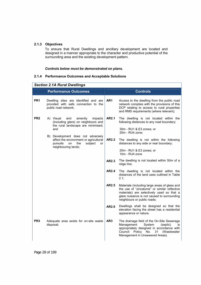
2.1.3 Objectives To ensure that Rural Dwellings and ancillary development are located and designed in a manner appropriate to the character and productive potential of the surrounding area and the existing development pattern. Controls below must be demonstrated on plans.
2.1.4 Performance Outcomes and Acceptable Solutions
Section 2.1A Rural Dwellings
Performance Outcomes
Controls
PR1 Dwelling sites are identified and are provided with safe connection to the public road network;
AR1
Access to the dwelling from the public road network complies with the provisions of this DCP relating to access to rural properties and RMS requirements (where relevant);
PR2
A) Visual and amenity impacts (including glare) on neighbours and the rural landscape are minimised; and
B) Development does not adversely
affect the environment or agricultural pursuits on the subject or neighbouring lands;
AR2.1 AR2.2 AR2.3 AR2.4 AR2.5 AR2.6
The dwelling is not located within the following distances to any road boundary; 30m - RU1 & E3 zones; or 20m - RU4 zone; The dwelling is not within the following distances to any side or rear boundary; 20m - RU1 & E3 zones; or 10m - RU4 zone The dwelling is not located within 50m of a ridge line; The dwelling is not located within the distances of the land uses outlined in Table 2.1; Materials (including large areas of glass and the use of “zincalume” or similar reflective materials) are selectively used so that a glare nuisance is not caused to surrounding neighbours or public roads; Dwellings shall be designed so that the elevation facing the street has a residential appearance or nature.
PR3
Adequate area exists for on-site waste disposal;
AR3
The drainage field of the On-Site Sewerage Management System (septic) is appropriately designed in accordance with Council Policy No. 31 (Wastewater Management in Unsewered Areas).

Page 29 of 199
PR4
Dwellings are supplied with potable water and water for fire fighting reserves
AR4.1 AR4.2
The on-site water capture and storage for domestic purposes complies with the NSW BASIX scheme and any Certificate issued. The total water storage on site shall be compliant with the following:
• guidelines in Appendix E • include a firefighting reserve of
20,000 L (over and above any BASIX minimum); and
• fitted with a Stortz fitting. The above may mean a total volume in excess of Appendix E in some circumstances.
PR5
Land for erection of a dwelling is safe and suitable for the purpose.
AR5
On lands identified as former orchard lands: • Soil testing for pesticide residue is
required; and • Such testing shall demonstrate the
land is suitable for the intended use. PR6
Residential development shall be designed to reflect vehicle and occupant safety principles. In this regard, where there is: (a) A garage, carport or covered vehicle
housing area attached to a Class 1 living or residence; and
(b) A connecting door is proposed between a garage, carport or covered vehicle housing area attached to a Class 1 living or residence;
these shall have an effective barrier to prevent people (including specifically infants) from coming into conflict with motor vehicles. The following definitions are used in this Part:
Covered Vehicle Area is defined as any of thefollowing or any combination thereof-
(a) Covered vehicle parking area but opensided such as a carport or the like.
(b) Garage being a roofed and enclosed spacefor parking vehicles. Enclosed refers to anyor all sides.
(c) Any concrete vehicle parking space with nocover at time of construction.
Connecting door is any door that adjoins a‘covered vehicle area’ on or in the immediateadjoining wall (parallel or at any angle thereto).
AR6
PR6 is satisfied if a means (manual or electronic) is put in place to restrict a dwelling’s occupant or visitor from bringing into potential harm and occupant of that dwelling, whilst parking the motor vehicle. This may be done by any or a combination of the means contained in this section. This provision applies to all class 1, 2 and 10 buildings. Note: Compliance with this section is achieved if one of the options in Section 2.1.5 below, is satisfied.

Page 30 of 199
NOTE: for the purpose of this definition,immediate adjoining wall includes any wall of adwelling or part there of within 3 metres of thebounding construction of the ‘covered vehiclearea’ whether attached or covered or not.
2.1.5 Deemed to Satisfy Provisions for Compliance with Performance Outcome PR6:
When are Barriers Required Between a Dwelling and a Covered Vehicle Area?;
(a) A means of dividing vehicle areas shall be provided between any dwelling and any vehicle parking area within 3 metres thereof, by way of: (i) no connecting door in the entire wall/s that have any part
within 3 metres of the vehicle manoeuvring/parking area, or (ii) provision of a manual system to any connecting door from the
dwelling to the vehicle parking/manoeuvring area that children younger than 5 years are not capable of exiting the dwelling unsupervised; or
(iii) a combination of controlled locking mechanisms that electronically serve to operate to ensure no conflict between vehicle operation adjacent to a dwelling and the occupants of the said dwelling.
(b) Any system proposed shall be clearly designed and detailed on plans compliant with this section prior to release of any building approval or construction certificate.
1. Compliance by Separation;
(a) Compliance with this section is achieved by having no connecting door in any part of any wall that has all or part of that wall within 3 metres of an adjoining vehicle housing/parking area.
2. Connecting Door – Barrier Installation;
If a door is provided in any part of any wall that has all or part within 3 metres of an adjoining vehicle parking area such installation shall have a door assembly fitted with fittings and fixtures that shall be a minimum of: (a) the leaf door shall swing inward of the dwelling; and (b) no sliding or concertina door of any type shall be used; and (c) the door leaf shall be fitted with a hydraulic self closing fixture that is
at minimum a size 2 spring strength in accordance with AS4145.5. Note: In the case of unusually high or heavy doors, windy or draughty conditions, or special installations a larger power size of door closer should be used); and
(d) any door latch or passage set shall be installed at a minimum of 1500mm above finished floor level; and
(e) Any bolt or function that could, in normal usage, render a door leaf non-self latching shall not be incorporated.
Note: A non self-latching bolt (e.g. a dead bolt) will prevent the door from closing if left protruding while the door is open. Any
Page 31 of 199
electrically operated locking devices or bolts shall be self latching in the event of power failure and any activation switches installed 1500mm above finished floor level.
(f) If pairs of doors are used both leaves are to be self closing and self latching and shall include a selective sequence closing device
3. Combined Electric Vehicle Door and Passage Door;
Where an attached covered vehicle housing/parking area has a roller or shutter door that is capable of mechanical or automated usage, the following provisions shall apply: (a) no interconnecting door shall be provided from the vehicle
housing/parking area to the internal of the dwelling in line with part 1 of this section and the affected walls and openings as defined; or
(b) any interconnecting door to an enclosed covered vehicle area shall comply with parts 2 & 3 of this section and
(c) any garage opening vehicle door being either manually operated, or, having an electronically mutually exclusive reed switch on the internal access door that prevents the garage vehicle door from being opened whilst the internal access door is in, or opening to, an open position.
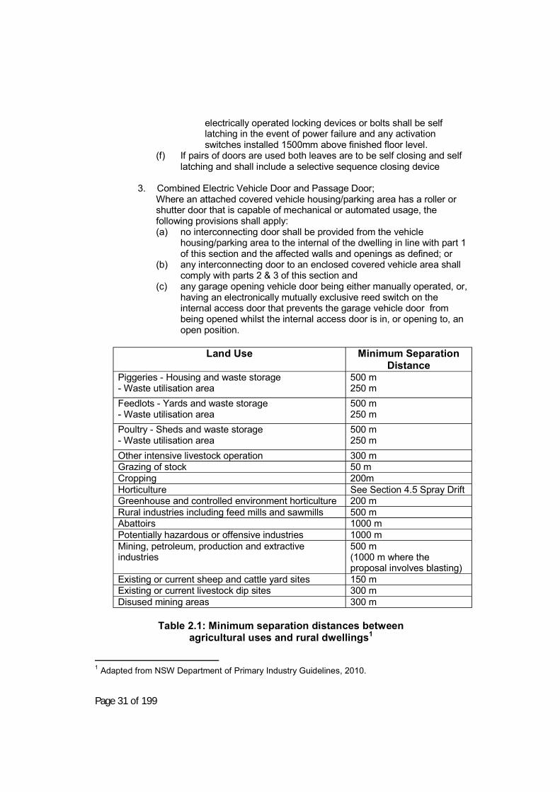
Land Use Minimum Separation
Distance Piggeries - Housing and waste storage - Waste utilisation area
500 m 250 m
Feedlots - Yards and waste storage - Waste utilisation area
500 m 250 m
Poultry - Sheds and waste storage - Waste utilisation area
500 m 250 m
Other intensive livestock operation 300 m Grazing of stock 50 m Cropping 200m Horticulture See Section 4.5 Spray Drift Greenhouse and controlled environment horticulture 200 m Rural industries including feed mills and sawmills 500 m Abattoirs 1000 m Potentially hazardous or offensive industries 1000 m Mining, petroleum, production and extractive industries
500 m (1000 m where the proposal involves blasting)
Existing or current sheep and cattle yard sites 150 m Existing or current livestock dip sites 300 m Disused mining areas 300 m
Table 2.1: Minimum separation distances between
agricultural uses and rural dwellings1
1 Adapted from NSW Department of Primary Industry Guidelines, 2010.

Page 27 of 199
Chapter 2. Zone Based Controls
Section 2.1. Rural Dwellings
Applies to RU1 Primary Production, RU4 Primary Production Small Lots and Environmental Zone E3.
2.1.1 Note regarding permissibility A dwelling must be permissible with consent under the Young Local Environmental Plan (LEP) 2010 on the land. This means the dwelling must either meet the minimum requirements for the size of land shown in the lot size map under the LEP or must be consistent with the provisions of clause 6.1 of the Young LEP 2010. If lots do not comply with the minimum lot size maps applicants are advised to seek legal advice that their proposal is permissible under the LEP prior to submitting an application.
2.1.2 Information to be provided The following information provides a guide to the minimum information requirements that Council will need to assess the application:
• An extract of a topographic (or similar) map showing the property
(including the allotment proposed for the dwelling and any holding/overall property boundary), the location of the dwelling and the location of powerlines;
• Electricity and any other utilities available or burdening the land; • Evidence of the size of the allotment, property and/or holding (e.g. copy of
the Deposited Plan, title certificates or similar); • The location of the proposed access road to the dwelling, and its
proposed point of connection with the public road network (Note: this point of connection must comply with the Young LEP 2010 and must comply with the access requirements for rural properties);
• Should the property be identified as bushfire prone land, a Planning for Bushfire Protection checklist, completed for the specific development. Note: This self-assessment is available from Council or the NSW Rural Fire Service;
• The location of the dams, streams and the like, including upstream drainage, drainage under public roads that flow onto the site;
• Details of the dwelling including plan and elevation, drawn to an appropriate metric scale, and indicating north point;
• Details of water supply including source of supply, and, where that is from a tank, details of calculations so as to ensure that water supply will be adequate to serve the dwelling. Note: Water supply information needs to address “Planning for Bushfire Protection” requirements and Council’s DCP requirements as appropriate;
• Details of effluent waste disposal, including type of system; • Submission of a BASIX Certificate.
Page 28 of 199
2.1.3 Objectives To ensure that Rural Dwellings and ancillary development are located and designed in a manner appropriate to the character and productive potential of the surrounding area and the existing development pattern. Controls below must be demonstrated on plans.
2.1.4 Performance Outcomes and Acceptable Solutions
Section 2.1A Rural Dwellings
Performance Outcomes
Controls
PR1 Dwelling sites are identified and are provided with safe connection to the public road network;
AR1
Access to the dwelling from the public road network complies with the provisions of this DCP relating to access to rural properties and RMS requirements (where relevant);
PR2
A) Visual and amenity impacts (including glare) on neighbours and the rural landscape are minimised; and
B) Development does not adversely
affect the environment or agricultural pursuits on the subject or neighbouring lands;
AR2.1 AR2.2 AR2.3 AR2.4 AR2.5 AR2.6
The dwelling is not located within the following distances to any road boundary; 30m - RU1 & E3 zones; or 20m - RU4 zone; The dwelling is not within the following distances to any side or rear boundary; 20m - RU1 & E3 zones; or 10m - RU4 zone The dwelling is not located within 50m of a ridge line; The dwelling is not located within the distances of the land uses outlined in Table 2.1; Materials (including large areas of glass and the use of “zincalume” or similar reflective materials) are selectively used so that a glare nuisance is not caused to surrounding neighbours or public roads; Dwellings shall be designed so that the elevation facing the street has a residential appearance or nature.
PR3
Adequate area exists for on-site waste disposal;
AR3
The drainage field of the On-Site Sewerage Management System (septic) is appropriately designed in accordance with Council Policy No. 31 (Wastewater Management in Unsewered Areas).

Page 29 of 199
PR4
Dwellings are supplied with potable water and water for fire fighting reserves
AR4.1 AR4.2
The on-site water capture and storage for domestic purposes complies with the NSW BASIX scheme and any Certificate issued. The total water storage on site shall be compliant with the following:
• guidelines in Appendix E • include a firefighting reserve of
20,000 L (over and above any BASIX minimum); and
• fitted with a Stortz fitting. The above may mean a total volume in excess of Appendix E in some circumstances.
PR5
Land for erection of a dwelling is safe and suitable for the purpose.
AR5
On lands identified as former orchard lands: • Soil testing for pesticide residue is
required; and • Such testing shall demonstrate the
land is suitable for the intended use. PR6
Residential development shall be designed to reflect vehicle and occupant safety principles. In this regard, where there is: (a) A garage, carport or covered vehicle
housing area attached to a Class 1 living or residence; and
(b) A connecting door is proposed between a garage, carport or covered vehicle housing area attached to a Class 1 living or residence;
these shall have an effective barrier to prevent people (including specifically infants) from coming into conflict with motor vehicles. The following definitions are used in this Part:
Covered Vehicle Area is defined as any of thefollowing or any combination thereof-
(a) Covered vehicle parking area but opensided such as a carport or the like.
(b) Garage being a roofed and enclosed spacefor parking vehicles. Enclosed refers to anyor all sides.
(c) Any concrete vehicle parking space with nocover at time of construction.
Connecting door is any door that adjoins a‘covered vehicle area’ on or in the immediateadjoining wall (parallel or at any angle thereto).
AR6
PR6 is satisfied if a means (manual or electronic) is put in place to restrict a dwelling’s occupant or visitor from bringing into potential harm and occupant of that dwelling, whilst parking the motor vehicle. This may be done by any or a combination of the means contained in this section. This provision applies to all class 1, 2 and 10 buildings. Note: Compliance with this section is achieved if one of the options in Section 2.1.5 below, is satisfied.
Page 30 of 199
NOTE: for the purpose of this definition,immediate adjoining wall includes any wall of adwelling or part there of within 3 metres of thebounding construction of the ‘covered vehiclearea’ whether attached or covered or not.
2.1.5 Deemed to Satisfy Provisions for Compliance with Performance Outcome PR6:
When are Barriers Required Between a Dwelling and a Covered Vehicle Area?;
(a) A means of dividing vehicle areas shall be provided between any dwelling and any vehicle parking area within 3 metres thereof, by way of: (i) no connecting door in the entire wall/s that have any part
within 3 metres of the vehicle manoeuvring/parking area, or (ii) provision of a manual system to any connecting door from the
dwelling to the vehicle parking/manoeuvring area that children younger than 5 years are not capable of exiting the dwelling unsupervised; or
(iii) a combination of controlled locking mechanisms that electronically serve to operate to ensure no conflict between vehicle operation adjacent to a dwelling and the occupants of the said dwelling.
(b) Any system proposed shall be clearly designed and detailed on plans compliant with this section prior to release of any building approval or construction certificate.
1. Compliance by Separation;
(a) Compliance with this section is achieved by having no connecting door in any part of any wall that has all or part of that wall within 3 metres of an adjoining vehicle housing/parking area.
2. Connecting Door – Barrier Installation;
If a door is provided in any part of any wall that has all or part within 3 metres of an adjoining vehicle parking area such installation shall have a door assembly fitted with fittings and fixtures that shall be a minimum of: (a) the leaf door shall swing inward of the dwelling; and (b) no sliding or concertina door of any type shall be used; and (c) the door leaf shall be fitted with a hydraulic self closing fixture that is
at minimum a size 2 spring strength in accordance with AS4145.5. Note: In the case of unusually high or heavy doors, windy or draughty conditions, or special installations a larger power size of door closer should be used); and
(d) any door latch or passage set shall be installed at a minimum of 1500mm above finished floor level; and
(e) Any bolt or function that could, in normal usage, render a door leaf non-self latching shall not be incorporated.
Note: A non self-latching bolt (e.g. a dead bolt) will prevent the door from closing if left protruding while the door is open. Any

Page 31 of 199
electrically operated locking devices or bolts shall be self latching in the event of power failure and any activation switches installed 1500mm above finished floor level.
(f) If pairs of doors are used both leaves are to be self closing and self latching and shall include a selective sequence closing device
3. Combined Electric Vehicle Door and Passage Door;
Where an attached covered vehicle housing/parking area has a roller or shutter door that is capable of mechanical or automated usage, the following provisions shall apply: (a) no interconnecting door shall be provided from the vehicle
housing/parking area to the internal of the dwelling in line with part 1 of this section and the affected walls and openings as defined; or
(b) any interconnecting door to an enclosed covered vehicle area shall comply with parts 2 & 3 of this section and
(c) any garage opening vehicle door being either manually operated, or, having an electronically mutually exclusive reed switch on the internal access door that prevents the garage vehicle door from being opened whilst the internal access door is in, or opening to, an open position.
Land Use Minimum Separation
Distance Piggeries - Housing and waste storage - Waste utilisation area
500 m 250 m
Feedlots - Yards and waste storage - Waste utilisation area
500 m 250 m
Poultry - Sheds and waste storage - Waste utilisation area
500 m 250 m
Other intensive livestock operation 300 m Grazing of stock 50 m Cropping 200m Horticulture See Section 4.5 Spray Drift Greenhouse and controlled environment horticulture 200 m Rural industries including feed mills and sawmills 500 m Abattoirs 1000 m Potentially hazardous or offensive industries 1000 m Mining, petroleum, production and extractive industries
500 m (1000 m where the proposal involves blasting)
Existing or current sheep and cattle yard sites 150 m Existing or current livestock dip sites 300 m Disused mining areas 300 m
Table 2.1: Minimum separation distances between
agricultural uses and rural dwellings1
1 Adapted from NSW Department of Primary Industry Guidelines, 2010.

Page 34 of 199
Section 2.2. Single Residential Development Applies to all zones where residential development is permissible, except rural and environmental zones.
2.2.1 Note regarding Single Residential Development Single residential development includes a single dwelling, all landscaping and access/service areas, as well as any outbuildings, such as garden sheds, detached studios/workshops etc.
2.2.2 Definition Site coverage (gross building area) means the proportion of a site area covered by buildings. However the following are not included for the purpose of calculating site coverage:
• Ancillary outbuildings such as swimming pools, sheds, garages and the like;
• Any basement; • Any part of the awning that is outside the outer walls of a building and that
adjoins the street frontage or other site boundary; • Any eaves; • Unenclosed balconies, decks, pergolas and the like.
2.2.3 Objectives To ensure that residential development is of high visual quality and amenity, while minimising amenity impacts on surrounding development.
2.2.4 Performance Outcomes and Acceptable Solutions Where no specific control stated, demonstrated compliance with the performance outcome is required.
Controls below must be demonstrated on plans.
Section 2.2A Single Residential Dwellings
Performance Outcomes
Controls
PSR1
The development takes advantage of the attributes of the site, by:
ASR1 Site Design
PSR1
The development shall use the slope of the land, its orientation to the sun and other site attributes to achieve an appropriate design for the specific site.
ASR1.1 ASR1.2
Cut and fill shall be limited to a maximum of 1 metre cut and 1 metre fill. Construction within registered easements or over utilities is avoided.

Page 35 of 199
ASR1.3 ASR1.4 ASR1.5
Construction over any natural watercourse/natural drainage lines through the land is prohibited. The property access shall be located respectful of street trees, structures or fixtures in the road reserve. On lands identified as former orchard lands:
• Soil testing for pesticide residue is required; and
• Such testing shall demonstrate the land is suitable for the intended use.
PSR2 The development respects the character of the neighbourhood by:
ASR2 Character of the Neighbourhood
PSR2.1
The development shall provide attractive streetscapes, comprising trees, gardens, building facades (i.e. the exterior of the building), fences and walls;
ASR2.1.1 ASR2.1.2 ASR2.1.3
Fencing forward of the front building line shall be:
• an open style (incorporating pickets, vertical stiles, slats or palings); or
• vegetative screening/ plantings, no greater than 1.2m in height.
Dwellings fronting a street shall address that street frontage by:
• The primary entrance door to the dwelling facing the street frontage.
• The front elevation incorporating windows to habitable rooms.
Materials (including large areas of glass and the use of “zincalume” or similar reflective materials) are selectively used so that a glare nuisance is not caused to surrounding neighbours or public roads;
PSR2.2
Dwellings shall ensure setbacks from the street alignment do not vary dramatically from those in the rest of the street in order to preserve neighbourhood and street presence.
ASR2.2.1
Dwellings are set back: 1. In the R1 General Residential
Zone, not less than 6m from the primary street frontage and not less than 3m from any secondary street frontage; or
Page 36 of 199
ASR2.2.2
2. In the R5 Large Lot Residential Zone, not less than 10 m from the primary street frontage, and not less than 6m from any secondary street; or
3. In both R1 and R5 zones, if the adjoining dwelling has differing setbacks, the average of those setbacks.
Garages in dwellings directly addressing the street do not project in front of other parts of the dwelling and, preferably, are recessed behind the front facade of the dwelling;
PSR2.3 The dwelling shall be appropriately
located on the site with setbacks that ensure privacy, overshadowing and amenity are respected within the neighbourhood;
ASR2.3.1 ASR2.3.2
Side and rear setbacks (excluding secondary street frontage) for dwellings in the R1 General Residential Zone are setback as follows;
1. Single Storey Dwellings • 3m, unless windows are
offset to achieve a reasonable expectation of privacy between the new development and the existing adjoining development.
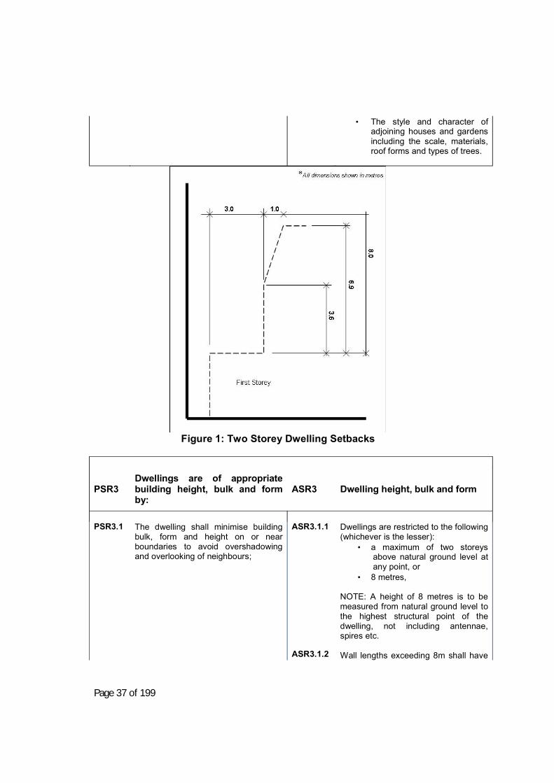
2. Two storey dwellings (Figure 1) • have the upper level set
back from side or rear boundaries by 3m, plus 0.3m for every metre of height over 3.6 metres up to 6.9 metres, plus 1 metre for every metre of height over 6.9 metres;
Dwellings in the R5 Large Lot Residential Zone are setback not less than 10m from the rear and side boundaries, excluding secondary street frontages;
PSR2.4 Dwellings shall be respective of, or
improve on, the quality of development in the neighbourhood, when viewed from the street.
PSR2.4.1
PSR2.4 may be achieved by, but not necessarily limited to:
• Design cues being drawn from surrounding dwellings, including window forms, external facade treatments and roof materials and pitches that are common within the neighbourhood; and
Page 37 of 199
• The style and character of adjoining houses and gardens including the scale, materials, roof forms and types of trees.
Figure 1: Two Storey Dwelling Setbacks
PSR3 Dwellings are of appropriate building height, bulk and form by:
ASR3 Dwelling height, bulk and form
PSR3.1
The dwelling shall minimise building bulk, form and height on or near boundaries to avoid overshadowing and overlooking of neighbours;
ASR3.1.1 ASR3.1.2
Dwellings are restricted to the following (whichever is the lesser):
• a maximum of two storeys above natural ground level at any point, or
• 8 metres, NOTE: A height of 8 metres is to be measured from natural ground level to the highest structural point of the dwelling, not including antennae, spires etc. Wall lengths exceeding 8m shall have

Page 38 of 199
wall offsets, openings or articulation of some manner.
PSR3.2
The development shall minimise hardstand areas for aesthetics and stormwater and surface water nuisance impacts;
ASR3.2.1 ASR3.2.2 ASR3.2.3
Permeable areas are at least 40% of the site; A maximum of 30% of the area forward of the front building setback is occupied by paving, access driveways or the like; Site coverage (gross building area) does not exceed 40% of the site;
PSR3.3 The development shall create usable
outdoor living spaces for occupants comfort, health and enjoyment;
ASR3.3
Private open space for the dwelling must be located adjoining living rooms, or the like, within the dwelling.
PSR4 Development provides access and parking by: ASR4 Access and Parking
PSR4.1
The development shall provide adequate parking for the development respectful of the configuration of the street, in order to avoid site and street congestion.
ASR4.1.1
ASR4.1.2
Car parking is provided in the following requirements;
• Two spaces, covered or uncovered, (stacked parking permitted);
• car parking space (not including a parallel to wall space) is to be a minimum of 2.6m wide by 5.5m long;
• Car parking spaces parallel to a wall shall be a minimum of 2.8m wide by 5.5m long;
• Enclosed car parking spaces shall be a minimum of 3m wide by 6m long;
For dwellings in cul-de-sacs, if the site does not have a minimum frontage that enables one car to be parked in front of the site, the site shall contain the ability to park one visitor car on-site in addition to the required number of parking spaces.
PSR4.2
Access driveways through the road reserve (from road edge to property boundary) shall be of a safe and suitable standard.
ASR4.2.1 ASR4.2.2
Access driveways (from road edge to property boundary) serving dwellings shall be constructed to the standards set in Council’s Engineering Guidelines for Subdivision and Development. Cross grades for access driveways and parking areas do not exceed 4% grade.

Page 39 of 199
ASR4.2.3
Access driveways to any required parking spaces onsite are provided through a single width crossover (maximum 3.5m wide);
PSR5
Development is served by necessary utilities and services including:
ASR5 Utilities and Services
PSR5.1
The dwelling shall be connected to Council’s reticulated water and sewer systems where available or obligated to be connected under relevant legislation and Council’s Development Servicing Plan;
ASR5.1.1 ASR5.1.2 ASR5.1.3 ASR5.1.4
Council’s reticulated water service shall be connected to the dwelling. Council’s reticulated sewer service shall be connected to the dwelling. Dwellings on an allotment greater than 2ha in Zone R5 may be considered by Council without reticulated water and sewerage. Payment of any headworks contributions for water and/or sewer. Refer to Young Shire Council’s and Golden Fields County Council development contributions plans and Development Servicing Plans that may apply to the development.
PSR5.2
The development shall have appropriate stormwater drainage connected, where possible into Council’s existing stormwater infrastructure.
ASR5.2.1 ASR5.2.2
All stormwater from the property shall be disposed of without causing nuisance. This may involve connection to Council’s existing drainage system or other suitable arrangements such as easements. Payment of any headworks contributions for stormwater. Refer to Young Shire Council’s Stormwater development contributions plans and/or Development Servicing Plans that may apply to the development.
PSR6
Development is designed to ensure vehicle and occupant safety:
ASR6 Vehicle and Occupant Safety
PSR6
Residential development shall be designed to reflect vehicle and occupant safety principles. In this
ASR6
Performance Requirement PSR6 is satisfied if a means (manual or electronic) is put in place to restrict a

Page 40 of 199
regard, where there is: (a) A garage, carport or covered
vehicle housing area attached to a Class 1 living or residence; and
(b) A connecting door is proposed between a garage, carport or covered vehicle housing area attached to a Class 1 living or residence;
these shall have an effective barrier to prevent people (including specifically infants) from coming into conflict with motor vehicles. The following definitions are used in thisPart:
Covered Vehicle Area is defined as any ofthe following or any combination thereof-(d) Covered vehicle parking area but
open sided such as a carport or thelike.
(e) Garage being a roofed and enclosedspace for parking vehicles. Enclosedrefers to any or all sides.
(f) Any concrete vehicle parking spacewith no cover at time of construction.
Connecting door is any door that adjoinsa ‘covered vehicle area’ on or in theimmediate adjoining wall (parallel or at anyangle thereto).
NOTE: for the purpose of this definition,immediate adjoining wall includes any wallof a dwelling or part there of within 3metres of the bounding construction of the‘covered vehicle area’ whether attached orcovered or not.
dwelling’s occupant or visitor from bringing into potential harm and occupant of that dwelling, whilst parking the motor vehicle. This may be done by any or a combination of the means contained in this section. This provision applies to all class 1, 2 and 10 buildings. Note: Compliance with this section is achieved if one of the options in Section 2.1.5 is satisfied.

Page 41 of 199
Section 2.2B Ancillary Development to Single Residential Dwellings (garden sheds, free standing carports, garages, water storage tanks, awnings, pergolas, decks etc) Note: The site, neighbourhood and parking provisions identified in Single Residential Dwellings above shall be considered in addition to the below controls when designing ancillary development. Where an inconsistency occurs between the below outcomes and controls, and Section 2.2A Single Residential Dwellings, the below outcomes controls shall prevail for the zone stated, to the extent of the inconsistency.
Performance Outcomes
Controls PAD1
Ancillary development shall be sited to minimise visual impact on how the residential property addresses the streetscape; and Ancillary development shall be sited to ensure practical serviceability.
AAD1.1 AAD1.2 AAD1.3
Ancillary development shall be setback 6m from the primary street frontage and at least 3m from any secondary street frontage on corner allotments. Ancillary development shall be no closer to the side and rear boundaries than 900mm. Materials (such as reflective, zinc or tin finishes) are selectively used so that a glare nuisance is not caused to surrounding neighbours or public roads.
This section does not necessarily contain every design consideration relevant to ancillary development. This does not exempt the application from having a Statement of Environmental Effects. A Statement of Environmental Effects will require the applicant to describe height, size, colour, location (setbacks) and give details on any potential amenity impacts to adjoining existing or potential development. Appendix C of this DCP contains information on preparing a Statement of Environmental Effects.

Page 45 of 199
Section 2.3. Multi-dwelling Residential Development Multi-dwelling development includes all development where there are two or more dwellings on a lot in R1 General Residential, R5 Large Lot Residential and B4 Mixed Use. For Dual Occupancy in RU5 Village, please refer to Section 2.10 of this DCP. For the purposes of this section, a dwelling shall include a unit, villa, townhouse, or the like.
2.3.1 Objectives To ensure that residential development is of high visual quality and amenity, while minimising amenity impacts on surrounding development. Controls below must be demonstrated on plans.
2.3.2 Performance Outcomes and Acceptable Solutions
Section 2.3A Multi Dwelling Residential
Performance Outcomes
Controls
PMD1 The development takes advantage of the attributes of the site, by:
AMD1 Site Design
PMD1
The development shall use the slope of the land, its orientation to the sun and other site attributes to achieve an appropriate design for the specific site.
PMD1.1 PMD1.2 PMD1.3 PMD1.4 PMD1.5
Cut and fill shall be limited to a maximum of 1 metre cut and 1 metre fill. Construction within registered easements or over utilities is avoided. Construction over any natural watercourse/natural drainage lines through the land is prohibited. The property access shall be located respectful of street trees, structures or fixtures in the road reserve. On lands identified as former orchard lands:
• Soil testing for pesticide residue is required; and
• Such testing shall demonstrate the land is suitable for the intended use.
Page 46 of 199
P2 The development respects the character of the neighbourhood by:
A2 Character of the Neighbourhood
PMD2.1
The development shall provide attractive streetscapes, comprising trees, gardens, building facades (i.e. the exterior of the building), fences and walls;
AMD2.1.1 AMD2.1.2 AMD2.1.3 AMD2.1.4 AMD2.1.5
Fencing forward of the front building line shall be:
• an open style (incorporating pickets, vertical stiles, slats or palings);
• or vegetative screening/ plantings, no greater than 1.2m in height.
Dwellings fronting a street shall address that street frontage by:
• The primary entrance door to the dwelling facing the street frontage.
• The front elevation incorporating windows to habitable rooms.
Materials (including large areas of glass and the use of “zincalume” or similar reflective materials) are selectively used so that a glare nuisance is not caused to surrounding neighbours or public roads; Landscaping is provided to the street frontage, which includes canopy trees, shrubs and grass; Driveways to rear dwellings are not fenced forward of the front building setback. Notwithstanding this clause, vegetative screening or landscaping are encouraged at this location;
PMD2.2 Providing each dwelling with clear and
distinct access, preferably visible from a public street.
AMD2.2 The development shall be designed such that public access to all occupancies is readily discernable from the front driveway access.
PMD2.3
Dwellings shall ensure setbacks from the street alignment do not vary dramatically from those in the rest of the street in order to preserve neighbourhood and street presence.
AMD2.3.1
Dwellings are set back:
1. In the R1 General Residential Zone, not less than 6m from the primary street frontage and not less than 3m from any secondary street frontage; or
2. In the R5 Large Lot Residential Zone, not less than

Page 47 of 199
AMD2.3.2
10 m from the primary street frontage, and not less than 6m from any secondary street; or
3. If adjoining dwelling has differing setbacks, the average of those setbacks.
Garages in dwellings directly addressing the street do not project in front of other parts of the dwelling and, preferably, are recessed behind the front facade of the dwelling;
PMD2.4 The dwelling shall be appropriately
located on the site with setbacks to adjoining or adjacent properties that ensure privacy, overshadowing and amenity are respected within the neighbourhood;
AMD2.4.1 AMD2.4.2
Setbacks to side and rear boundaries (excluding secondary street frontage) for dwellings in the R1 General Residential Zone shall be as follows; 1. Single Storey dwellings;
• 3m, or • Between 3m and 1.5m, with
the use of techniques such as o windows 1.5m above
finished floor level, or o fixed opaque glass (note,
smaller windows in service rooms such as laundries or the like may have an open pane), or
o any other means that meet the stated performance outcome and specifically detailed and designed by the applicant.
• No building setbacks less than 1.5m from boundaries.
2. Two storey dwellings
• have the upper level set back from side or rear boundaries by 3m, plus 0.3m for every metre of height over 3.6 metres up to 6.9 metres, plus 1 metre for every metre of height over 6.9 metres;
Dwellings in the R5 Large Lot Residential Zone are setback at least 10m from the rear and side boundaries, excluding secondary street frontages;
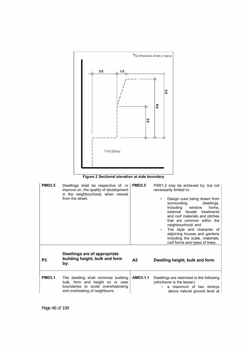
Page 48 of 199
Figure 2 Sectional elevation at side boundary
PMD2.5 Dwellings shall be respective of, or
improve on, the quality of development in the neighbourhood, when viewed from the street.
PMD2.5
PSR1.2 may be achieved by, but not necessarily limited to:
• Design cues being drawn from surrounding dwellings, including window forms, external facade treatments and roof materials and pitches that are common within the neighbourhood; and
• The style and character of adjoining houses and gardens including the scale, materials, roof forms and types of trees.
P3
Dwellings are of appropriate building height, bulk and form by:
A3 Dwelling height, bulk and form
PMD3.1
The dwelling shall minimise building bulk, form and height on or near boundaries to avoid overshadowing and overlooking of neighbours;
AMD3.1.1
Dwellings are restricted to the following (whichever is the lesser):
• a maximum of two storeys above natural ground level at
Page 49 of 199
AMD3.1.2
any point, or • 8 metres,
NOTE: A height of 8 metres is to be measured from natural ground level to the highest structural point of the dwelling, not including antennae, spires etc. Wall lengths exceeding 8m shall have wall offsets, openings or articulation of some manner.
PMD3.2
The development shall minimise hardstand areas for aesthetics and stormwater and surface water nuisance impacts;
AMD3.2.1 AMD3.2.2 AMD3.2.3
Permeable areas are at least 20% of the site; A maximum of 30% of the area forward of the front building setback is occupied by paving, access driveways or the like; Site coverage (gross building area) does not exceed 60% of the site.
PMD3.3 The development shall create usable
outdoor living spaces for occupants comfort, health and enjoyment
AMD3.3.1 AMD3.3.2
Private open space is provided for the dwelling by adjoining living rooms or the like within the dwelling. Private open space is provided for each dwelling (immediately adjoining that dwelling) at a minimum area of 48m2 per dwelling, which is able to contain a rectangle of 8m x 4m. NOTE: For the purposes of achieving the required minimum area above, no part of the minimum area shall have a width of less than 3m;
PMD3.4 The scale of a second dwelling shall
be smaller than the existing dwelling to assist in the integration of the new building into the neighbourhood.
AMD3.4 Second dwellings on an allotment with an existing dwelling are no more than 80% of the floor area of the existing dwelling.
PMD4 Development provides access and parking by:
AMD4 Access and Parking
PMD4.1
The development shall provide adequate parking for the development respectful of the configuration of the street, in order to avoid site and street congestion.
AMD4.1.1
Car parking is provided in accordance with the following requirements; 1. Dual occupancy
• 1 or 2 bedroom dwellings – 1 space (undercover),
• 3 or more bedroom dwellings -
Page 50 of 199
AMD4.1.2 AMD4.1.3 AMD4.1.4 AMD4.1.5
2 spaces (at least 1 to be undercover – stack parking not permitted),
2. 3 or more dwellings
• 1 bedroom dwellings – 1 space (undercover)
• 2 or more bedroom dwellings - 2 spaces (at least 1 to be undercover – stack parking not permitted),
PLUS
• 1 visitor parking space per 3
dwellings (maybe uncovered – stack parking not permitted).
Car parking space dimensions shall comply with the following standards:
• car parking space (not including a parallel to wall space) is to be a minimum of 2.6m wide by 5.5m long;
• Car parking spaces parallel to a wall shall be a minimum of 2.8m wide by 5.5m long;
• Enclosed car parking spaces shall be a minimum of 3m wide by 6m long;
For dwellings in cul-de-sacs, if the site does not have a minimum frontage that enables one car to be parked in front of the site, the site shall contain the ability to park one visitor car on-site in addition to the required number of parking spaces. Visitor parking (where required) is easily accessible and clearly designated by line-marking and signage; All parking areas and trafficable areas on-site shall be sealed with bitumen, concrete (preferably coloured) and textured or pavers.
PMD4.2 To ensure sufficient circulation and
movement on site is achieved so as to allow vehicles to enter and leave the site in a forward direction without giving rise to congestion.
PMD4.2.1
The width of internal accessways (not including turning areas, parking etc) shall be as follows:
• 3m wide - to service 1 - 2 dwellings,
• 6m wide - to service 3 or more

Page 51 of 199
dwellings. NOTE: Notwithstanding the above, the development shall be designed to allow for additional width of internal accesways for passing purposes.
PMD4.3
Ensuring vehicle access to and from the site is safe;
AMD4.3.1 Vehicles accessing dwellings (other than dwellings served directly from the street frontage) as well as visitors to a development must be able to enter and leave the development in the forward direction. NOTE: The 85th percentile vehicle must be able to turn on-site in no more than a two-point turn;
PMD4.4 Minimising the number and width of
access driveways (from road edge to property boundary) consistent with the traffic function of those driveways. NOTE: For the purposes of this provision a ‘access driveway’ is defined as being from the road edge to the property boundary
AMD4.4.1 AMD4.4.2
Access is provided through a single consolidated access driveway from a public road; No lane access is relied on for site access/egress;
PMD4.5 Access driveways through road
reserve (from road edge to property boundary) shall be of a safe and suitable standard. NOTE: For the purposes of this provision a ‘access driveway’ is defined as being from the road edge to the property boundary
AMD4.5.1 AMD4.5.2 AMD4.5.3
Access driveways directly serving double garages do not exceed 3.5m in width at the property boundary; Access driveways shall be concreted (preferably coloured), sealed or paved and if serving:
two dwellings are no more than 3m in width along their length;
more than 2 dwellings are no more than 5.5m in width.
dwellings within the R5 zone are constructed of an all-weather surface, such as compacted road base material.
NOTE: Access driveways may exceed the above minimum at the kerb by no more than 0.5m
Access driveways (from road edge to property boundary) serving dwellings shall be constructed to the standards set in Council’s Engineering Guidelines for Subdivision and Development.
Page 52 of 199
AMD4.5.4
Cross grades for access driveways and parking areas do not exceed 4% grade.
PMD4.6
The development shall provide a suitable pedestrian network
AMD4.6
A 1.5 m footpath is provided to all frontages of the development;
PMD4.7 The development shall provide road
infrastructure suitable for the development.
AMD4.7
If not already provided, roadways directly adjacent to the development are to be provided with kerb and gutter, including, where necessary, shoulder widening and seal to Council’s standards. Cost of such works are to be paid by the developer.
PMD5
Development is served by necessary utilities and services including:
AMD5 Utilities and Services
PMD5.1
The dwellings shall be connected to Council’s reticulated water and sewer systems where available or obligated to be connected under relevant legislation and Council’s Development Servicing Plan;
AMD5.1.1 AMD5.1.2
Council’s reticulated water service shall be connected separately to each dwelling. Council’s reticulated sewer service shall be connected to the dwellings.
PMD5.2
The dwellings shall have appropriate stormwater drainage connected, where possible, into Council’s existing stormwater infrastructure.
AMD5.2.1 AMD5.2.2
All stormwater from the property shall be disposed of without causing nuisance. This may involve connection to Council’s existing stormwater drainage system or other suitable arrangements such as easements. For 3 or more dwellings, all roof and surface water drainage shall be designed to provide for conveyance of these flows per AS3500 after considering the Australian Rainfall and Runoff Guidelines, to the appropriate road, public stormwater drainage system or watercourse where approved to do so.
PMD5.3 The development shall make a
contribution towards the provision of services and infrastructure.
AMD5.3 Payment of any headworks contributions for water and/or sewer. Refer to Young Shire Council’s Stormwater development contributions plans and/or Development Servicing Plans that may apply to the development.
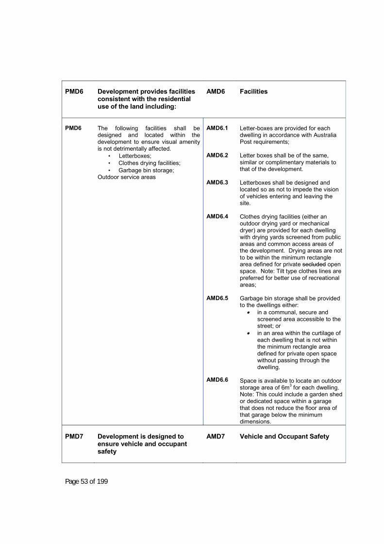
Page 53 of 199
PMD6 Development provides facilities
consistent with the residential use of the land including:
AMD6 Facilities
PMD6
The following facilities shall be designed and located within the development to ensure visual amenity is not detrimentally affected.
• Letterboxes; • Clothes drying facilities; • Garbage bin storage;
Outdoor service areas
AMD6.1 AMD6.2 AMD6.3 AMD6.4 AMD6.5 AMD6.6
Letter-boxes are provided for each dwelling in accordance with Australia Post requirements; Letter boxes shall be of the same, similar or complimentary materials to that of the development. Letterboxes shall be designed and located so as not to impede the vision of vehicles entering and leaving the site. Clothes drying facilities (either an outdoor drying yard or mechanical dryer) are provided for each dwelling with drying yards screened from public areas and common access areas of the development. Drying areas are not to be within the minimum rectangle area defined for private secluded open space. Note: Tilt type clothes lines are preferred for better use of recreational areas; Garbage bin storage shall be provided to the dwellings either:
in a communal, secure and screened area accessible to the street; or
in an area within the curtilage of each dwelling that is not within the minimum rectangle area defined for private open space without passing through the dwelling.
Space is available to locate an outdoor storage area of 6m3 for each dwelling. Note: This could include a garden shed or dedicated space within a garage that does not reduce the floor area of that garage below the minimum dimensions.
PMD7 Development is designed to
ensure vehicle and occupant safety
AMD7 Vehicle and Occupant Safety

Page 54 of 199
PMD7
Residential development shall be designed to reflect vehicle and occupant safety principles. In this regard, where there is: (a) A garage, carport or covered
vehicle housing area attached to a Class 1 living or residence; and
(b) A connecting door is proposed between a garage, carport or covered vehicle housing area attached to a Class 1 living or residence;
these shall have an effective barrier to prevent people (including specifically infants) from coming into conflict with motor vehicles. The following definitions are used in thisPart:
Covered Vehicle Area is defined as any ofthe following or any combination thereof-(j) Covered vehicle parking area but
open sided such as a carport or thelike.
(k) Garage being a roofed and enclosedspace for parking vehicles. Enclosedrefers to any or all sides.
(l) Any concrete vehicle parking spacewith no cover at time of construction.
Connecting door is any door that adjoinsa ‘covered vehicle area’ on or in theimmediate adjoining wall (parallel or at anyangle thereto).
NOTE: for the purpose of this definition,immediate adjoining wall includes any wallof a dwelling or part there of within 3metres of the bounding construction of the‘covered vehicle area’ whether attached orcovered or not.
AMD7
Performance Requirement PMD7 is satisfied if a means (manual or electronic) is put in place to restrict a dwelling’s occupant or visitor from bringing into potential harm and occupant of that dwelling, whilst parking the motor vehicle. This may be done by any or a combination of the means contained in this section. This provision applies to all class 1, 2 and 10 buildings. Note: Compliance with this section is achieved if one of the options in Section 2.1.5 is satisfied.

Page 55 of 199
Section 2.3B Ancillary Development to Multi-Dwelling Residential Development (garden sheds, free standing carports, garages, water storage tanks, awnings, pergolas, decks etc) Note: The site, neighbourhood, open space and parking provisions identified in Multi-Dwelling Residential Development above shall be considered in addition to the below controls when designing ancillary development.
Performance Outcomes
Controls PMA1
Ancillary development shall be sited to minimise visual impact on how the residential property addresses the streetscape; and Ancillary development shall be sited to ensure practical serviceability.
AMA1.1 AMA1.2 AMA1.3 AMA1.4
Ancillary development shall be setback 6m from the primary street frontage and at least 3m from any secondary street frontage on corner allotments. Ancillary development shall be no closer to the side and rear boundaries than 900mm. Materials (such as reflective, zinc or tin finishes) are selectively used so that a glare nuisance is not caused to surrounding neighbours or public roads. No ancillary structure shall be permitted within the required private open space area originally approved with the development.
This section does not necessarily contain every design consideration relevant to ancillary development. This does not exempt the application from having a Statement of Environmental Effects. A Statement of Environmental Effects will require the applicant to describe height, size, colour, location (setbacks) and give details on any potential amenity impacts to adjoining existing or potential development. Appendix C of this DCP contains information on preparing a Statement of Environmental Effects.
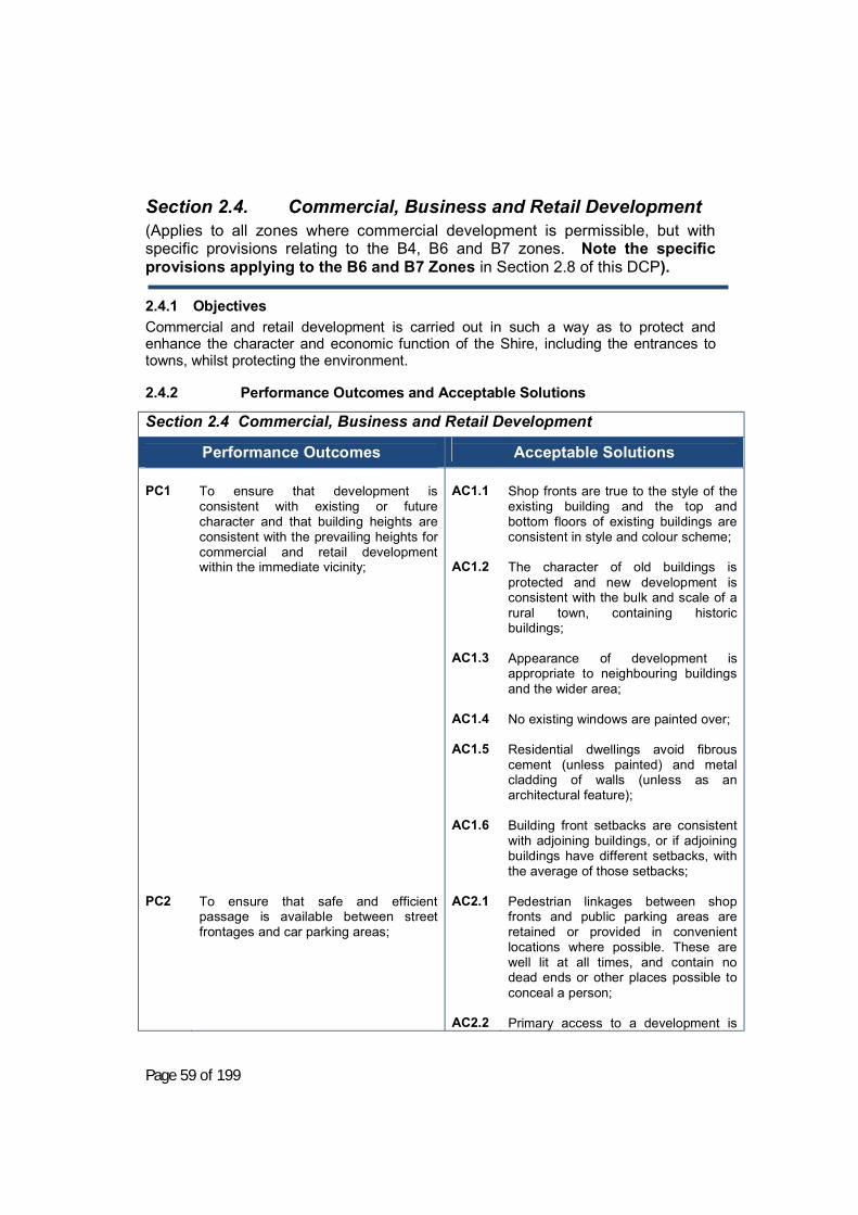
Page 59 of 199
Section 2.4. Commercial, Business and Retail Development (Applies to all zones where commercial development is permissible, but with specific provisions relating to the B4, B6 and B7 zones. Note the specific provisions applying to the B6 and B7 Zones in Section 2.8 of this DCP).
2.4.1 Objectives Commercial and retail development is carried out in such a way as to protect and enhance the character and economic function of the Shire, including the entrances to towns, whilst protecting the environment.
2.4.2 Performance Outcomes and Acceptable Solutions
Section 2.4 Commercial, Business and Retail Development
Performance Outcomes
Acceptable Solutions PC1 PC2
To ensure that development is consistent with existing or future character and that building heights are consistent with the prevailing heights for commercial and retail development within the immediate vicinity; To ensure that safe and efficient passage is available between street frontages and car parking areas;
AC1.1 AC1.2 AC1.3 AC1.4 AC1.5 AC1.6 AC2.1 AC2.2
Shop fronts are true to the style of the existing building and the top and bottom floors of existing buildings are consistent in style and colour scheme; The character of old buildings is protected and new development is consistent with the bulk and scale of a rural town, containing historic buildings; Appearance of development is appropriate to neighbouring buildings and the wider area; No existing windows are painted over; Residential dwellings avoid fibrous cement (unless painted) and metal cladding of walls (unless as an architectural feature); Building front setbacks are consistent with adjoining buildings, or if adjoining buildings have different setbacks, with the average of those setbacks; Pedestrian linkages between shop fronts and public parking areas are retained or provided in convenient locations where possible. These are well lit at all times, and contain no dead ends or other places possible to conceal a person; Primary access to a development is
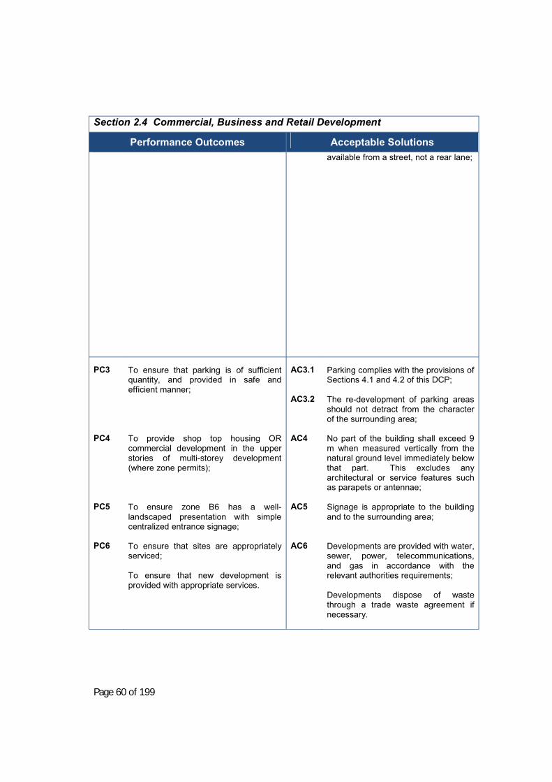
Page 60 of 199
Section 2.4 Commercial, Business and Retail Development
Performance Outcomes
Acceptable Solutions
available from a street, not a rear lane;
PC3 PC4 PC5 PC6
To ensure that parking is of sufficient quantity, and provided in safe and efficient manner; To provide shop top housing OR commercial development in the upper stories of multi-storey development (where zone permits); To ensure zone B6 has a well-landscaped presentation with simple centralized entrance signage; To ensure that sites are appropriately serviced; To ensure that new development is provided with appropriate services.
AC3.1 AC3.2 AC4 AC5 AC6
Parking complies with the provisions of Sections 4.1 and 4.2 of this DCP; The re-development of parking areas should not detract from the character of the surrounding area; No part of the building shall exceed 9 m when measured vertically from the natural ground level immediately below that part. This excludes any architectural or service features such as parapets or antennae; Signage is appropriate to the building and to the surrounding area; Developments are provided with water, sewer, power, telecommunications, and gas in accordance with the relevant authorities requirements; Developments dispose of waste through a trade waste agreement if necessary.

Page 61 of 199
2.4.3 Design Suggestions and Variations Council will consider the provision of concessions (possibly including car parking) for development fronting Boorowa Street where developments provide pedestrian access to car parking areas via arcades or passageways having 3m minimum width.

Page 62 of 199
Section 2.5. Food Premises - Additional Provisions
2.5.1 Objectives a) To ensure that food preparation and storage protects public health and protects
Council infrastructure.
2.5.2 Performance Outcomes and Acceptable Solutions
Performance Outcomes
Acceptable Solutions
PF1 PF2 PF3 PF4 PF5 PF6
Food preparation and storage areas are constructed to allow easy cleaning; Food is stored in accordance with good practice; Handling of food minimises risks to public health; Adequate customer facilities are provided; Disposal of wastes to the public sewer is within the capacity of that infrastructure (both in terms of the quantity and type of material being disposed of). Location of trade waste facilities shall enable easy access for servicing.
AF1 AF4 AF5
Compliance with the Australian Standard for Food Premises (AS 4674); Provision of customer sanitary facilities (as required by the BCA). Compliance with Council's trade waste policy;
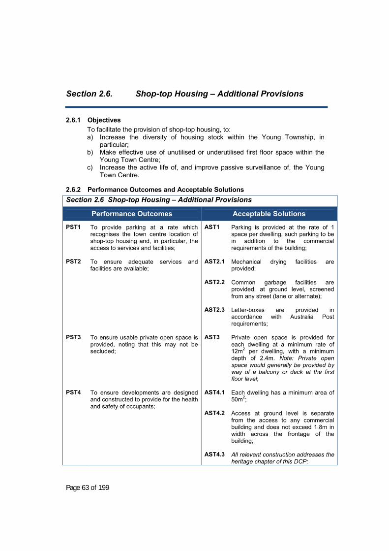
Page 63 of 199
Section 2.6. Shop-top Housing – Additional Provisions
2.6.1 Objectives To facilitate the provision of shop-top housing, to: a) Increase the diversity of housing stock within the Young Township, in
particular; b) Make effective use of unutilised or underutilised first floor space within the
Young Town Centre; c) Increase the active life of, and improve passive surveillance of, the Young
Town Centre.
2.6.2 Performance Outcomes and Acceptable Solutions Section 2.6 Shop-top Housing – Additional Provisions
Performance Outcomes
Acceptable Solutions
PST1 PST2 PST3 PST4
To provide parking at a rate which recognises the town centre location of shop-top housing and, in particular, the access to services and facilities; To ensure adequate services and facilities are available; To ensure usable private open space is provided, noting that this may not be secluded; To ensure developments are designed and constructed to provide for the health and safety of occupants;
AST1 AST2.1 AST2.2 AST2.3 AST3 AST4.1 AST4.2 AST4.3
Parking is provided at the rate of 1 space per dwelling, such parking to be in addition to the commercial requirements of the building; Mechanical drying facilities are provided; Common garbage facilities are provided, at ground level, screened from any street (lane or alternate); Letter-boxes are provided in accordance with Australia Post requirements; Private open space is provided for each dwelling at a minimum rate of 12m2 per dwelling, with a minimum depth of 2.4m. Note: Private open space would generally be provided by way of a balcony or deck at the first floor level; Each dwelling has a minimum area of 50m2; Access at ground level is separate from the access to any commercial building and does not exceed 1.8m in width across the frontage of the building; All relevant construction addresses the heritage chapter of this DCP;

Page 64 of 199
Section 2.6 Shop-top Housing – Additional Provisions
Performance Outcomes
Acceptable Solutions AST4.4
All construction complies with the BCA;
PST5
Development is served by necessary utilities and services including:
• Telephone/data; • Water, sewer, power and gas; • On-site water storage; • Drainage.
AST4.5
AST5
Residential dwellings avoid fibrous cement (unless painted) and metal cladding of walls (unless as an architectural feature). Separately metered power and water is provided to each dwelling;
Note: headworks and/or development servicing plan charges may be applicable to the development. Applicants are advised to contact Council’s Utilities Services Division to determine these charges, which are payable prior to the release of any Construction Certificate.
2.6.3 Design Suggestions and Variations Council may give consideration to waiving carparking requirements in return for a contribution for carparking.

Page 65 of 199
Section 2.7. Heritage Conservation Area - Additional Provisions
2.7.1 History and Character of the Young Heritage Conservation Area
2.7.1.1 History of the Young Conservation Area Young Heritage Conservation Area has significance to the development of Young Shire. Details of the heritage of Young Shire are available from:
• Community Based Heritage Study of the Young Shire October 2008, and • Thematic History of Young Shire, NSW Heritage Office 2008.
Both are available on Council’s website, and should be referenced in preparing any heritage impact statements.
2.7.1.2 Character of the Young Conservation Zone The town of Young was developed in the midst of the Burrangong Gold Field. Shops, hotels and other business establishments developed along the line of Boorowa Street from 1860 onwards. The business district was firmly established by the 1870s. A number of catastrophic fires destroyed much of the early fabric of the town, however many buildings survive from the late 19th century.
The Young Conservation Zone contains a collection of buildings of remarkably diverse style. This diversity reflects the ongoing commercial strength of the town. Young is reflected in the diversity of architectural styles representing Victorian, Federation and Moderne trends as follows;
• Victorian era buildings include the state significant Young Railway
Station, Young Town Hall and former City Bank, as well as interesting styles such as the Victorian Mannerist Style Hall of Commerce.
• The extensive Inter-War building stock includes the Art Deco former
Commonwealth Bank, Warehouse Style Millard’s Store and other landmarks including the Mediterranean Style Commercial Hotel.
• The work of local architect Neville Lipman is represented in former
service stations located on the corners of Boorowa and Clarke Streets and Lovell and Main Streets.
2.7.1.3 Notes on development in an area with potential heritage or archaeological significance
Aboriginal heritage and archaeology
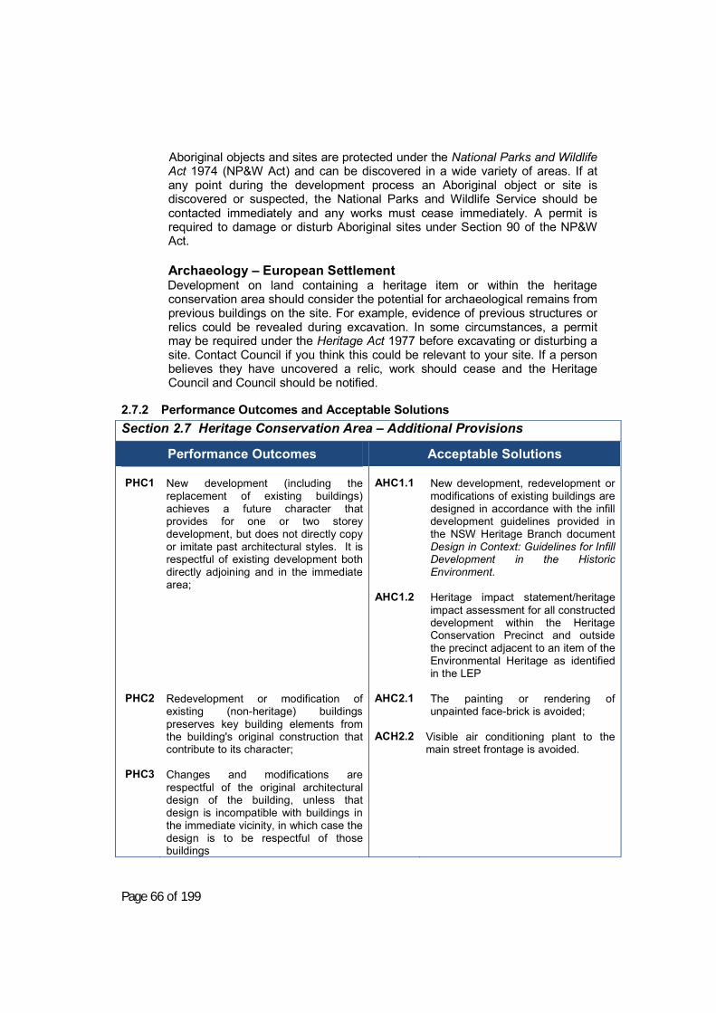
Page 66 of 199
Aboriginal objects and sites are protected under the National Parks and Wildlife Act 1974 (NP&W Act) and can be discovered in a wide variety of areas. If at any point during the development process an Aboriginal object or site is discovered or suspected, the National Parks and Wildlife Service should be contacted immediately and any works must cease immediately. A permit is required to damage or disturb Aboriginal sites under Section 90 of the NP&W Act.
Archaeology – European Settlement Development on land containing a heritage item or within the heritage conservation area should consider the potential for archaeological remains from previous buildings on the site. For example, evidence of previous structures or relics could be revealed during excavation. In some circumstances, a permit may be required under the Heritage Act 1977 before excavating or disturbing a site. Contact Council if you think this could be relevant to your site. If a person believes they have uncovered a relic, work should cease and the Heritage Council and Council should be notified.
2.7.2 Performance Outcomes and Acceptable Solutions Section 2.7 Heritage Conservation Area – Additional Provisions
Performance Outcomes
Acceptable Solutions
PHC1
PHC2
PHC3
New development (including the replacement of existing buildings) achieves a future character that provides for one or two storey development, but does not directly copy or imitate past architectural styles. It is respectful of existing development both directly adjoining and in the immediate area; Redevelopment or modification of existing (non-heritage) buildings preserves key building elements from the building's original construction that contribute to its character; Changes and modifications are respectful of the original architectural design of the building, unless that design is incompatible with buildings in the immediate vicinity, in which case the design is to be respectful of those buildings
AHC1.1
AHC1.2
AHC2.1 ACH2.2
New development, redevelopment or modifications of existing buildings are designed in accordance with the infill development guidelines provided in the NSW Heritage Branch document Design in Context: Guidelines for Infill Development in the Historic Environment. Heritage impact statement/heritage impact assessment for all constructed development within the Heritage Conservation Precinct and outside the precinct adjacent to an item of the Environmental Heritage as identified in the LEP The painting or rendering of unpainted face-brick is avoided;
Visible air conditioning plant to the main street frontage is avoided.

Page 67 of 199
2.7.3 Design suggestions and variations Any variations are accompanied by a full heritage assessment from an experienced heritage architect as listed with the NSW Department of Planning Heritage Branch.

Page 68 of 199
Section 2.8. Enterprise Corridor (B6) and Business Park (B7) Zones - Additional Provisions
2.8.1 Objectives a) To establish a future character for buildings that address the Olympic
Highway
2.8.2 Performance Outcomes and Acceptable Solutions
Section 2.8 Enterprise Corridor (B6) and Business Park (B7) Zones – Additional Provisions
Performance Outcomes
Acceptable Solutions PEB1 PEB2 PEB3 PEB4 PEB5
Signage is simple, effective and centralized; Vehicle access is safe, shared and centralised (particularly where access is gained from a Classified road); Gateways to Young achieve quality development that enhances the character of the town and avoids “ribbon style” commercial and retail development; Parking is easily visible and accessible; The existing treed character of key gateways to Young is maintained and enhanced, in particular along the Olympic Highway,
AEB1 AEB2.1 AEB2.2 AEB2.3 AEB3.1 AEB3.2 AEB3.3 AEB4.1 AEB4.2 AEB5.1 AEB5.2
Site signage (other than on a building) is consolidated into a single pylon sign wholly contained within the site boundary; Access is gained by means other than direct access from the Olympic Highway where practicable. Access and egress is available the site in a forward direction; Access, parking and signage are to RTA standards (Referral required); Any façades visible from the Olympic Highway to be constructed of brick, decorative masonry, glass or other quality materials; Frontages are upgraded to standards required in Section 2.9, the Industrial Section of this DCP; Development achieves a floor space ratio of no more than 0.5:1; Have some parking that is directly visible from the street frontage Note: Including in front of the building; Parking provision in accordance with Section 4 of this DCP. Existing canopy trees are protected and incorporated into site landscaping; Are provided with landscaping over at least 50% of land between the building
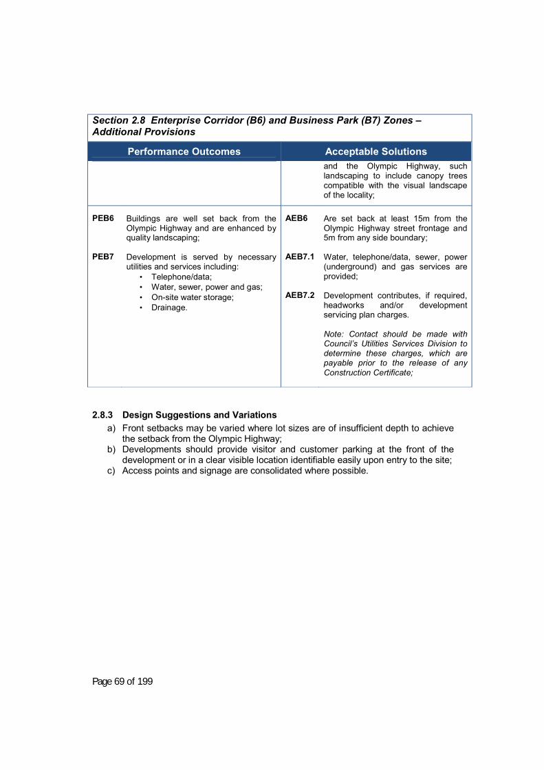
Page 69 of 199
Section 2.8 Enterprise Corridor (B6) and Business Park (B7) Zones – Additional Provisions
Performance Outcomes
Acceptable Solutions
and the Olympic Highway, such landscaping to include canopy trees compatible with the visual landscape of the locality;
PEB6 PEB7
Buildings are well set back from the Olympic Highway and are enhanced by quality landscaping; Development is served by necessary utilities and services including:
• Telephone/data; • Water, sewer, power and gas; • On-site water storage; • Drainage.
AEB6 AEB7.1 AEB7.2
Are set back at least 15m from the Olympic Highway street frontage and 5m from any side boundary; Water, telephone/data, sewer, power (underground) and gas services are provided; Development contributes, if required, headworks and/or development servicing plan charges. Note: Contact should be made with Council’s Utilities Services Division to determine these charges, which are payable prior to the release of any Construction Certificate;
2.8.3 Design Suggestions and Variations a) Front setbacks may be varied where lot sizes are of insufficient depth to achieve
the setback from the Olympic Highway; b) Developments should provide visitor and customer parking at the front of the
development or in a clear visible location identifiable easily upon entry to the site; c) Access points and signage are consolidated where possible.

Page 70 of 199
Section 2.9. Industrial Development
2.9.1 Objectives a) To ensure that industrial allotments function effectively for industrial purposes,
and b) To improve the appearance of industrial areas when viewed from a public place.
2.9.2 Performance Outcomes and Acceptable Solutions Section 2.9 Industrial Development
Performance Outcomes
Acceptable Solutions
PID1
To ensure that new development is adequately serviced and does not place undue loads on public infrastructure
AID1.1
AID1.2
Servicing: All industrial allotments are serviced by underground electricity, water, sewer and telecommunications in accordance with the relevant authorities’ requirements and relevant Australian Standards; • An compliant potable water supply
is connected to all new developments;
• Development complies with part J of the BCA and provides a rainwater tank to amenities;
• Separate occupancy has separate sanitary and stormwater drainage lines with independent connection to external lines.
• Developments comply with Council’s trade waste policy;
Development contributes, if required, headworks and/or development servicing plan charges. Note: Contact should be made with Council’s Utilities Services Division to determine these charges, which are payable prior to the release of any Construction Certificate.
PID2
To ensure that roads, allotment access and parking areas are constructed to a standard that is durable and suitable for the proposed use;
AID2.1
Access and Parking Site access, on-site vehicle circulation areas and manoeuvring areas are provided in accordance with the Access and Parking requirements in Section 4 of the DCP OR in
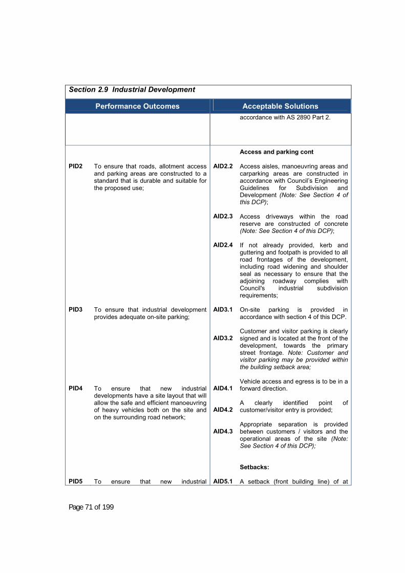
Page 71 of 199
Section 2.9 Industrial Development
Performance Outcomes
Acceptable Solutions
accordance with AS 2890 Part 2.
PID2
PID3
PID4 PID5
To ensure that roads, allotment access and parking areas are constructed to a standard that is durable and suitable for the proposed use; To ensure that industrial development provides adequate on-site parking; To ensure that new industrial developments have a site layout that will allow the safe and efficient manoeuvring of heavy vehicles both on the site and on the surrounding road network; To ensure that new industrial
AID2.2 AID2.3 AID2.4
AID3.1 AID3.2
AID4.1 AID4.2 AID4.3
AID5.1
Access and parking cont Access aisles, manoeuvring areas and carparking areas are constructed in accordance with Council’s Engineering Guidelines for Subdivision and Development (Note: See Section 4 of this DCP); Access driveways within the road reserve are constructed of concrete (Note: See Section 4 of this DCP); If not already provided, kerb and guttering and footpath is provided to all road frontages of the development, including road widening and shoulder seal as necessary to ensure that the adjoining roadway complies with Council's industrial subdivision requirements; On-site parking is provided in accordance with section 4 of this DCP. Customer and visitor parking is clearly signed and is located at the front of the development, towards the primary street frontage. Note: Customer and visitor parking may be provided within the building setback area; Vehicle access and egress is to be in a forward direction. A clearly identified point of customer/visitor entry is provided; Appropriate separation is provided between customers / visitors and the operational areas of the site (Note: See Section 4 of this DCP); Setbacks: A setback (front building line) of at

Page 72 of 199
Section 2.9 Industrial Development
Performance Outcomes
Acceptable Solutions developments do not result in unacceptable noise, vibration or overshadowing impacts on adjoining or nearby properties;
least 15 m is provided from a classified road frontage; and a setback of at least 6 m is provided from any other road frontage;
PID5
To ensure that new industrial developments do not result in unacceptable noise, vibration or overshadowing impacts on adjoining or nearby properties;
AID5.2
A building setback of at least 5 m is provided from all side or rear boundaries, unless the building is constructed to the boundary. Note: a building should only be constructed to the boundary where adjoining another industrial allotment.
AID5.3 AID5.4 AID5.5
Buffers: Buildings adjoining non-industrial development: Are set back a minimum of 10 m from the property boundary; Do not have a wall height exceeding 8m; Do not produce any additional overshadowing of the adjoining property between the hours of 9 AM-3 PM on 21st June.
AID5.6 AID5.7
Noise and Vibration: Building design and machinery installation effectively minimises any noise emissions. Note: in general, all machinery is to be contained within buildings or other acoustic treatment structures. Openings to the building which are usually open during operations should be directed away from sensitive receivers such as residential housing; Building design and machinery installation prevents significant vibration transmission to adjoining properties or public areas. Note: If the development includes vibration producing machinery, the DA should include confirmation that the

Page 73 of 199
Section 2.9 Industrial Development
Performance Outcomes
Acceptable Solutions
transmitted vibration to a sensitive receiver such as a dwelling would not be at a level so as to result in loss of amenity to neighbours. Professional advice would need to be sought in this regard.
PID5
PID6
To ensure that new industrial development (including significant extensions) is appropriate to the streetscape and context; To ensure that industrial buildings present acceptably to the public realm in terms of;
• Facade treatment • Landscaping and fencing • signage
AID5.8 AID5.9
AID6.1
Noise and Vibration cont: The operating noise level of plant and equipment does not exceed 5dBA above the background noise level when measured from the property boundary. Note: for potentially noisy developments, an acoustic study prepared by a qualified and experienced acoustic engineer should be submitted with the development application demonstrating that this threshold would not be exceeded at the nearest sensitive receiver. General design: The majority of offices and/or customer areas and/or staff facilities are located so as to address the primary road frontage of the development. These are generally located in a part of the building that does not exceed one storey in height; Façade treatment: The front façade of the building is constructed from face brick or decorative masonry block; or timber panelling, pre-coloured metal cladding, and glazing in conjunction with a reasonable proportion of brick or masonry block (greater than 30%). Note: Other types of materials may be considered depending on the character and streetscape of the immediate area;

Page 74 of 199
Section 2.9 Industrial Development
Performance Outcomes
Acceptable Solutions AID6.2 AID6.3
Where the building is on a corner allotment, the front façade treatment is extended at least 5 metres down the side of the building facing a side road. Landscaping and fencing: Landscaping is selected from the list of suitable tree species for Young Shire, as outlined in Appendix G.
PID6
To ensure that industrial buildings present acceptably to the public realm in terms of;
• Facade treatment • Landscaping and fencing • signage
AID6.4 AID6.5 AID6.6 AID6.7
Landscaping and fencing cont: Landscaping is provided to the primary street frontage(s) with such landscaping being low maintenance and occupying not less than 20% of the area between the industrial building setback line and the street; Vegetation to be planted is a mixture of semi-mature species and seedlings/tube stock to generate both an immediate visual effect, and good overall establishment in the medium term. Note: a list of suitable plant species for the Young Shire area is located in Appendix G; Canopy trees are provided on properties located on classified roads between the front boundary and the building line, sufficient to break up the building bulk; Fencing is provided of a uniform colour and material along all common boundaries, and
a. Solid fencing is not more than 1.8m above the finished ground level;
b. The total height of the fence is not more than 2.4m.
c. Additional fencing, screen walls or screen vegetation is provided to conceal unsightly areas from neighbour or public view (e.g. storage areas for particular materials/goods/rubbish);

Page 75 of 199
Section 2.9 Industrial Development
Performance Outcomes
Acceptable Solutions AID6.8
AID6.9
Fencing to a street or other public place is of open and durable construction. Note: suitable materials include coated chain wire, fence designed mesh, open treated metal or open timber fencing.
Signage: Signage is appropriately located and designed so as clearly convey business names and services etc, but without detracting from the appearance of the area or causing issues for adjoining properties, road users, or others in the surrounding area.
2.9.3 Design Suggestions and Variations a) The necessary fire ratings under the Building Code of Australia need to
achieved when parts of the building are constructed to a boundary. This would generally require concrete or masonry walls;
b) Crime and safety issues in NSW Police Force program “Safer by Design” such as lighting, security and cameras where needed should be considered in the planning of the development;
c) Siting for economy under the BCA may cause severe constraints. The
maximum use of site should be entertained as opposed to “dead” setback zones;
d) Narrow and/or unfrequented areas which would be difficult to maintain should
be avoided; e) Signage can either be included with the initial development application, or
subject to a separate application to Council, unless the signage is exempt development. (Note: Exempt and Complying development is included under the Young LEP 2010, SEPP 60 Exempt and Complying Development and SEPP No. 64 Advertising and Signage);
f) “Nose in” parking, directly off a public road, is generally discouraged but may
be accepted for existing development adjoining a local road where the following is able to be achieved:
a. not within 10 m of an intersection or a roundabout; b. a public footpath of 1.5 m is able to be provided; c. not located where the road alignment would limit visibility all vehicles
entering or leaving the parking area;

Page 76 of 199
d. only on a lightly trafficked road; e. Road carriageway has a minimum width of 12 m kerb to kerb.

Page 77 of 199
2.9.4 Area Specific Provisions: James Lane In addition to the general provisions relating to industrial development, the following specific provisions applied to the James Lane industrial development area as shown on the diagram below:
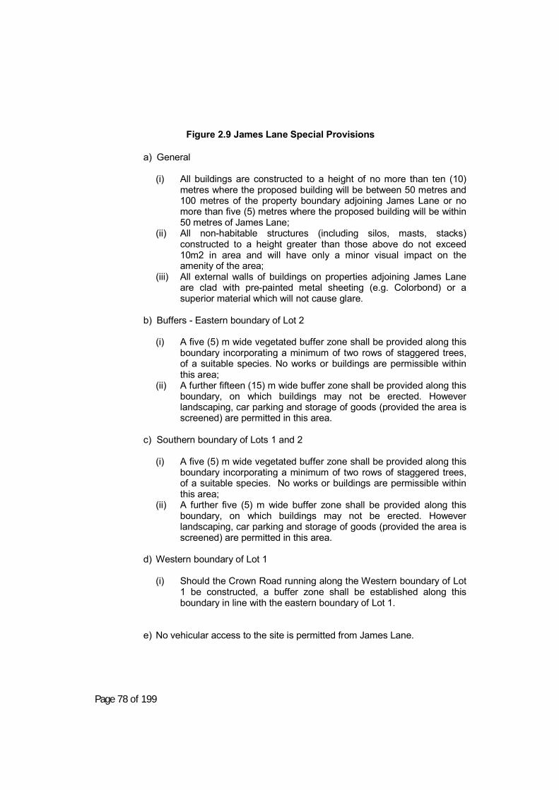
Page 78 of 199
Figure 2.9 James Lane Special Provisions
a) General
(i) All buildings are constructed to a height of no more than ten (10)
metres where the proposed building will be between 50 metres and 100 metres of the property boundary adjoining James Lane or no more than five (5) metres where the proposed building will be within 50 metres of James Lane;
(ii) All non-habitable structures (including silos, masts, stacks) constructed to a height greater than those above do not exceed 10m2 in area and will have only a minor visual impact on the amenity of the area;
(iii) All external walls of buildings on properties adjoining James Lane are clad with pre-painted metal sheeting (e.g. Colorbond) or a superior material which will not cause glare.
b) Buffers - Eastern boundary of Lot 2
(i) A five (5) m wide vegetated buffer zone shall be provided along this
boundary incorporating a minimum of two rows of staggered trees, of a suitable species. No works or buildings are permissible within this area;
(ii) A further fifteen (15) m wide buffer zone shall be provided along this boundary, on which buildings may not be erected. However landscaping, car parking and storage of goods (provided the area is screened) are permitted in this area.
c) Southern boundary of Lots 1 and 2
(i) A five (5) m wide vegetated buffer zone shall be provided along this
boundary incorporating a minimum of two rows of staggered trees, of a suitable species. No works or buildings are permissible within this area;
(ii) A further five (5) m wide buffer zone shall be provided along this boundary, on which buildings may not be erected. However landscaping, car parking and storage of goods (provided the area is screened) are permitted in this area.
d) Western boundary of Lot 1
(i) Should the Crown Road running along the Western boundary of Lot
1 be constructed, a buffer zone shall be established along this boundary in line with the eastern boundary of Lot 1.
e) No vehicular access to the site is permitted from James Lane.

Page 79 of 199
2.9.5 Design Suggestions and Variations This section has been left intentionally blank

Page 80 of 199
Section 2.10. Village Development – Zone RU5
2.10.1 Objectives a) To encourage and facilitate appropriate development within the village zones of
Young Shire; b) To maintain the low-scale and widely detached building character of the villages.
2.10.2 Performance Outcomes and Acceptable Solutions Section 2.10 Village Development – Zone RU5
Performance Outcomes
Acceptable Solutions
PV1 PV2 PV3
Residential building placement, scale and form on lots wholly or partially within RU5 zones is sympathetic to the surrounding neighbourhood character;
Commercial or industrial developments respect neighbourhood character and provide adequate facilities appropriate to the proposed use;
Where no reticulated water or sewer is available, roof areas, tank capacities and lot areas are large enough to enable the effective capture, storage, treatment and disposal of water in quantities appropriate to the development, without any negative impact on adjoining properties.
AV1.1 AV1.2 AV1.3 AV2.1 AV2.2 AV3.1 A3.2
Residential building setbacks are at least 10 metres to the front boundary line and 4 metres to the side boundaries; All residential dwellings are single storey or appear as such from the street frontage; Residential dwellings avoid fibrous cement (unless painted) and metal cladding of walls (unless as an architectural feature); Commercial or industrial uses are constructed with pre-painted metal with unpainted metal type finishes avoided. Note: This is a minimum requirement and other finishes are considered acceptable; All-weather parking areas (not necessarily sealed) are provided for commercial and industrial uses; Where there is no sewer available, the development is to comply with Council’s Policy with respect to the On-Site Management of waste disposal. Properties with an area of less than 1ha provide specific geotechnical investigation demonstrating the feasibility of on-site management; Where no reticulated water supply is available, roof areas and tanks are provided according to the guidelines in Appendix E including a firefighting reserve of 20,000 L fitted with a Stortz fitting, such reserve to be over and

Page 81 of 199
Section 2.10 Village Development – Zone RU5
Performance Outcomes
Acceptable Solutions above BASIX requirements (or as
otherwise specified by Planning for Bushfire Protection).
2.10.3 Design Suggestions and Variations a) Compliance with the relevant Chapter of this DCP for the development type
proposed (e.g residential, commercial and retail, industrial or rural) is encouraged;
b) Within the Village zone, Council may exercise flexibility regarding compliance with planning controls, provided the basic needs of the development are satisfied, and the development is consistent with the character of the locality;
c) Roof forms of residential buildings are encouraged to use hip or gable style and have a minimum pitch of approximately 20 degrees.
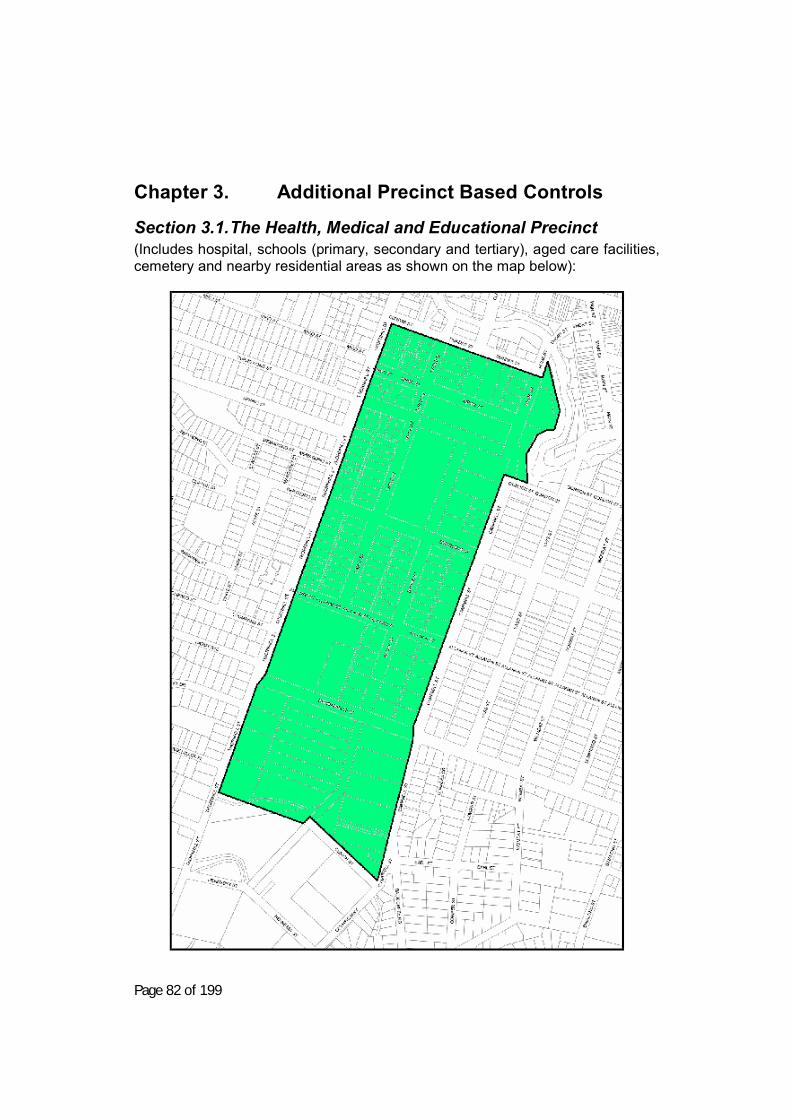
Page 82 of 199
Chapter 3. Additional Precinct Based Controls
Section 3.1. The Health, Medical and Educational Precinct (Includes hospital, schools (primary, secondary and tertiary), aged care facilities, cemetery and nearby residential areas as shown on the map below):

Page 83 of 199
Figure 3.1 Health, Medical and Educational Precinct
Section 3.1 The Health, Medical and Educational Precinct
3.1.1 Objectives a) To encourage uses which support the existing core uses within the
institutional precinct.
3.1.2 Functional Statements a) Staff housing is conveniently located within the precinct; b) In-house (cottage practices) are supported and developed; c) Education (non-mainstream) is supported and developed;
3.1.3 Performance Outcomes and Acceptable Solutions Section 3.1 The Health, Medical and Educational Precinct
Performance Outcomes
Acceptable Solutions
PH1 PH2 PH3
Medical centres are located within close proximity of hospitals or other medical facilities; New uses respect residential amenity. Traffic generating activities shall be approximately serviced in terms of car parking provisions.
AH1 AH2.1 AH3 AH2.2 AH2.3
Medical centres: Are located within 400 m of a hospital, other medical facility or aged care facility or are accessible by patient or community based transport services; Meet the building set back and height criteria for residential development; Meet the parking requirements set out in Section 4.1 of the DCP (Parking). Non-main-stream education centres and child-care centres: Are located in buildings which respect the mixed character of the precinct, being a combination of residential and institutional development; Protect neighbourhood amenity when located adjoining residences by achieving the design outcomes consistent with medium density development and managing noise;

Page 84 of 199
3.1.4 Design Suggestions and Variations N/A

Page 85 of 199
Chapter 4. Specific Provisions – All Zones
Section 4.1. Car Parking and Vehicle Access
4.1.1 Overall Objectives To provide a guide for the provision of parking, associated with development in Young Shire in order that:
a) Traffic safety and management are maintained or improved; b) Parking areas are provided that are convenient, functional and
sufficient for use; c) A balance is achieved between the needs of the proposed use
and of vehicular and pedestrian traffic; and d) Parking areas, once established, are maintained in an adequate
condition that continues to provide facilities that comply with those required when development consent was granted.
4.1.2 Parking Requirements
4.1.2.1 General Information The provisions of this chapter will be applied to new development. The provisions of this chapter will also be applied to the extension of an existing building or works as if it were an independent development. Off-street car parking provision now provided to existing developments shall be retained. Additional parking spaces required for any new development or redevelopment shall comply with the provisions of this document. In the case of a change in the use of an existing building, Council will apply the provisions of this DCP if it considers that the proposed new use will produce a substantially different parking requirement than those attributable to the existing use. The total number of on-site parking spaces provided in association with new development shall be in accordance with the recommended ratios set out in this Chapter as appropriate, subject to any qualifications or exceptions which may be applicable in the circumstances of the case. In this regard parking proposals that provide less parking than required by this Chapter shall be supported by a parking study. In the event of a conflict between this Chapter and an Australian Standard, the Australian Standard will prevail.

Page 86 of 199
Section 4.1 Car Parking and Vehicle Access
4.1.3 Objectives: a) To provide safe and accessible car parks. b) To provide sufficient car parks to serve the needs of particular
developments.
4.1.4 Performance Outcomes and Acceptable Solutions Section 4.1 Car Parking and Vehicle Access
Performance Outcomes
Acceptable Solutions PPA1 PPA2 PPA3
New car parks are sufficient in number and design to provide appropriately for the needs of new developments;
Parking areas are designed to operate in a safe manner for drivers and pedestrians. All parking bays must be readily accessible and an adequate area is provided for the turning and manoeuvring of vehicles;
APA1.1 APA1.2 APA2.1 APA2.2 APA3.1 APA3.2
APA3.3
Car parking is provided at the rate set out in Table 4.1; Car parking is provided on the site of the development; Vehicles enter and leave the site in a forward direction; All parking spaces are suitably marked by lines or spaces indicated by other approved means; The layout and dimensions of car parking areas are in accordance with the design standards and principles as set out in Figures 4.1 and 4.2; Unless specified to a different standard elsewhere in this DCP, all car parking areas, driveways, turning areas and loading areas are paved in either a bitumen seal coat, asphaltic or bituminous concrete, cement concrete, concrete paving blocks, or brick paving blocks. Note: The standard of paving required will be dependent upon the type of development proposed, with regard to traffic loadings including turning movements of heavy vehicles. For specific details refer to Council’s Engineering Subdivision and Development Guidelines; Free and uninterrupted access to car parking areas is maintained at all times.

Page 87 of 199

Page 88 of 199

Page 89 of 199
Figure 4.1 Recommended Carpark Dimensions

Page 90 of 199
Table 4:1 Car Park Provision - Acceptable Solutions Land & building use Rate of Provision
Backpackers’ accommodation, Boarding houses, Hostels, Hotels (unlicensed) and similar uses
1 space per 3 guest rooms, plus 1 space for a manager, plus 1 space per 3 employees or part thereof.
Accommodation
Tourist and visitor accommodation (other than backpackers’ accommodation)
1 space per guest room or unit, plus 1 space per 2 staff employed, plus 1 space per 7.5 square metres of bar and lounge areas
Warehouse or distribution centre 1 space per 100 square metres of gross leasable floor area
Office premises
1 space per 50 square metres of gross leasable floor area
Business premises 1 space per 35 square metres of gross leasable floor area.
Commercial, business and industrial
Industries 1 space per 2 staff employed, or 1 space per 100 square metres of gross leasable floor area (whichever is the greater)
Notes for all educational establishments
Note: Council will require the provision of on-site set-down and pick-up areas for buses and cars taking students to or from the school or colleges. Specific requirements depending on the educational use must also be met. Consultation with Council is strongly suggested as part of the site design process.
Pre-school, infants and Primary schools
1 space per staff employed, plus 2 service spaces
Secondary schools 1 space per staff employed, plus 2 service spaces, plus 1 space per 10 senior students (Years 11 and 12)
Education Establishments
Tertiary schools and Colleges 1 space per staff employed, plus 2 service spaces, plus 1 space per 5 students, plus 1 space per live-in student where residential accommodation is provided
Health services facility
1 space per 3 beds and/or 3 spaces per health care professional attending to outpatients, plus 1 space for each resident or staff doctor, plus 1 space for each three employees
Food and drink premises 1 space per 10 square metres of service area
Hospitality, entertainment and recreation Registered clubs 1 space per 2 staff employed, plus
1 space per 7.5 square metres of bar and lounge areas

Page 91 of 199
Land & building use Rate of Provision Bowling clubs 30 spaces per green or rink
Function Centre 1 space per 3 guests (from BCA calculated occupancy)
Entertainment facility 1 space per 5 seats Squash courts, tennis courts and bowling alleys
3 spaces per court or alley
Sports stadiums 1 space per 10 seats (or BCA calculated occupancy, whichever is the higher).
Places of public worship, funeral homes
1 space per 10 seats, or, if no seats, 1 space per 10 square metres of gross leasable floor area
Dual Occupancy
One or two bedroom unit: 1 on-site car parking space per unit; Three bedroom unit: 2 on-site car parking spaces per unit (at least one space to be covered);
Single Dwelling house 2 spaces (stack parking permitted for one space) per dwelling.
Multi dwelling housing (i.e. three or more dwellings – whether attached or detached – on one lot of land) and Residential flat buildings
One bedroom dwelling: 1 space (undercover) per dwelling; Dwellings containing two or more bedrooms: One (1) undercover space per dwelling; one additional space per dwelling (may be covered or uncovered); Visitor parking: One (1) space per three (3) dwellings or part thereof (may be uncovered).
Residential
Senior’s housing (other than a hostel)
1 space per 5 units plus 1 space for resident manager or as per requirements under SEPP (Housing for People with a Disability), whichever is the lesser
Shops, (including supermarkets less than 900 square metres gross leasable floor area)
1 space per 35 square metres of gross leasable floor area
Supermarkets (900 square metres gross leasable floor area or greater)
1 space per 20 square metres of gross leasable floor area
Service stations 1 space per 6 bowsers with additional spaces to be provided for other on-site uses in accordance with this Table.
Retail and services
Vehicle body repair workshops and Vehicle repair stations
4 spaces per service bay
Page 92 of 199
Land & building use Rate of Provision Vehicle sales or hire premises 1 space per 100 square metres of gross
leasable floor area of the building plus 1 space per 320 square metres of open display area – Note: this assumes one space is required per 16 cars displayed. One car display – equals 20 square metres
Note: This DCP defines parking standards for frequently encountered uses. The Council will define a requirement for uses not referred to in the DCP according to the merits of the specific case. The RTA Guide to Traffic Generating Development may be utilised in this instance, noting that this document requires updating and may not be relevant in all instances. Explanatory Notes 1. In this Chapter Gross Leasable Floor Area means the overall usable area of the
building excluding amenities, stairways, lift wells and plant rooms.
2. Unless otherwise stated ancillary or incidental uses will be assessed as part of the main user of the building i.e. the office of a supermarket will be included in the area of the supermarket and will not be treated as a separate office use.
3. A use comprising a combination of two or more uses such as combined vehicle sales and vehicle repair stations will be assessed as if the two uses existed independently and the required on-site parking provisions will be the aggregation of the independently derived requirements.
4. For the purpose of Table 4.1, "bedroom" is taken to be any room which would be available for use as a bedroom without structural alteration to the dwelling.
5. The parking provision for restaurants and function rooms may be reduced where it is demonstrated that the time of peak demand for parking associated with each facility does not coincide with peak usage of existing available parking or where common usage reduces total demand. Each case will be considered on its individual merits.
6. If the calculation of required car spaces results in a non-integer value such as 3.6, then this should be rounded up or down according to the following rule:
a) Partial values less than 0.5 can be rounded down (e.g. 4.4 can be rounded down to 4).
b) Partial values of 0.5 or more should be rounded up (e.g. 4.5 and 4.7 would both be rounded up to 5).

Page 93 of 199
4.1.5 Design Suggestions and Variations A design that complies with the relevant Australian Standard and/or any relevant State Environmental Planning Policies will be considered acceptable. Council normally expects the provision of car parking to be on the site of the development. If parking is not able to be provided, contributions for the provision of parking would be considered in accordance with any parking contribution plan applying to the area.
Page 94 of 199
Section 4.2. General Provisions for Car Parking Areas
4.2.1 Objectives This section applies to Class 2-9 Development under the BCA and also multi-dwelling residential development or where a designated carparking area is required.
a) To provide car parks and related infrastructure to acceptable standards of
construction.

Page 95 of 199
4.2.2 Performance Outcomes and Acceptable Solutions
Figure 4.2.1 Example of a car park layout showing various design elements
Section 4.2 General Provisions for Car Parking Areas
Performance Outcomes
Acceptable Solutions
PCP1
Parking operations are logical and the circulation pattern clearly defined through the use of appropriate traffic management measures;
ACP1
Compliance with Australian Standard AS2890 Part 1 and Part 2
Page 96 of 199
Section 4.2 General Provisions for Car Parking Areas
Performance Outcomes
Acceptable Solutions PCP2 PCP2.1 PCP2.2 PCP2.3 PCP2.4 PCP2.5
PCP2.6
Parking areas are designed to operate in a safe manner for drivers and pedestrians; The number of conflict points between vehicles, and between pedestrians and vehicles, is minimised; Pedestrians are separated from vehicular traffic as much as physically possible; For one-way traffic, circulation is in the clockwise direction; Solid walls or other obstructions to visibility are avoided on the inside of tight turns; Blind aisles longer than 15 metres are avoided;
Entry/exit points are clearly marked so as to avoid any confusion. Within the car park, signs are provided where necessary so that drivers wishing to leave the car park may do so by the most efficient route. Signposting is easily seen and understood;
ACP2 ACP2.2 ACP2.5.1
ACP2.5.2 ACP2.6
All car parking areas shall be lit in accordance with the relevant Australian Standard. Pedestrian thoroughfares are provided throughout the carparking area to fully separate pedestrian and vehicular traffic; Any blind aisles are:
• Less than 15m in length; • A minimum of 6.5 metres wide; • Clear of all obstructions; • Provided with a manoeuvring
area at the blind end of the aisle being a 2.5 metre extension of the aisle past the end of the last parking space; and allocated, where possible, for staff or other non-customer vehicles;
Where aisles are, in effect, internal roads leading to parking areas or individual garages, such as occur in villa home type developments, the following minimum dimensions are provided:
• Minor access aisles: 6m; • Minor feeder two way aisles:
5m;
Separations of entry and exits comply with Tables 4.2 and 4.3;
PCP2.7
Directional markings are clearly set out on the pavement in such a manner as to be easily readable and

Page 97 of 199
Section 4.2 General Provisions for Car Parking Areas
Performance Outcomes
Acceptable Solutions PCP2.8
PCP2.9 PCP2.10
understandable to the users of the car park; All parking bay delineations, arrows and other information for drivers painted on the pavement are marked using white (or high-contrast) paint or approved markers. Delineations are not less than 75mm or greater than 100mm wide; Note: In certain situations, the installation of signs to Council’s satisfaction may be required over and above the normal requirements. Signposting and linemarking will assist to prevent the choking of the aisles and contribute to the general ease of use of the facility. Details of all proposed signposting and marking for parking areas are to be submitted with the development application for Council’s consideration. Where the development generates a reasonable volume of traffic, separate entry and exit locations are provided with suitable separation between the access points;
Good visibility is provided at these locations and longitudinal grades provide for a holding area within the property;
ACP2.9.1 ACP2.9.2 ACP2.10
The design of access points and internal circulation areas is such that entry to and exit from the site is made by driving in a forward direction. Note: The reversing of vehicles onto the street will not generally be accepted, except for single residential dwelling houses and dual occupancies. Some minor relaxation may be permitted in this matter depending on the conditions of the site, the location of the site and the nature of the development; Access points are in accordance with the restrictions in Figure 4.4. Note: The minimum driveway width at the entry/exit points is to be selected having regard to the footpath crossing width; Holding areas have a maximum grade of 5% for a distance of not less than 6 metres in length immediately behind the road boundary. Note: For less intense traffic generating developments this distance may be reduced to 3 metres;
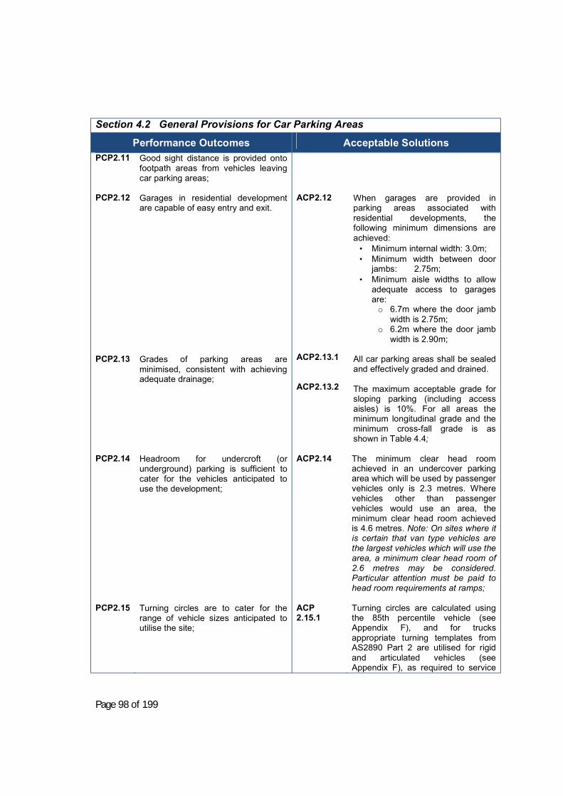
Page 98 of 199
Section 4.2 General Provisions for Car Parking Areas
Performance Outcomes
Acceptable Solutions PCP2.11 PCP2.12 PCP2.13 PCP2.14 PCP2.15
Good sight distance is provided onto footpath areas from vehicles leaving car parking areas; Garages in residential development are capable of easy entry and exit. Grades of parking areas are minimised, consistent with achieving adequate drainage; Headroom for undercroft (or underground) parking is sufficient to cater for the vehicles anticipated to use the development; Turning circles are to cater for the range of vehicle sizes anticipated to utilise the site;
ACP2.12 ACP2.13.1 ACP2.13.2 ACP2.14
ACP 2.15.1
When garages are provided in parking areas associated with residential developments, the following minimum dimensions are achieved:
• Minimum internal width: 3.0m; • Minimum width between door
jambs: 2.75m; • Minimum aisle widths to allow
adequate access to garages are: o 6.7m where the door jamb
width is 2.75m; o 6.2m where the door jamb
width is 2.90m;
All car parking areas shall be sealed and effectively graded and drained. The maximum acceptable grade for sloping parking (including access aisles) is 10%. For all areas the minimum longitudinal grade and the minimum cross-fall grade is as shown in Table 4.4; The minimum clear head room achieved in an undercover parking area which will be used by passenger vehicles only is 2.3 metres. Where vehicles other than passenger vehicles would use an area, the minimum clear head room achieved is 4.6 metres. Note: On sites where it is certain that van type vehicles are the largest vehicles which will use the area, a minimum clear head room of 2.6 metres may be considered. Particular attention must be paid to head room requirements at ramps; Turning circles are calculated using the 85th percentile vehicle (see Appendix F), and for trucks appropriate turning templates from AS2890 Part 2 are utilised for rigid and articulated vehicles (see Appendix F), as required to service
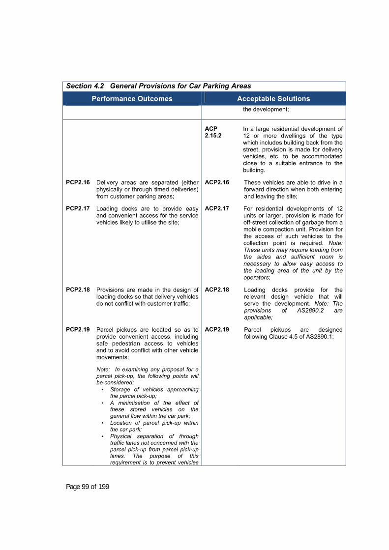
Page 99 of 199
Section 4.2 General Provisions for Car Parking Areas
Performance Outcomes
Acceptable Solutions
the development;
PCP2.16 PCP2.17
PCP2.18
PCP2.19
Delivery areas are separated (either physically or through timed deliveries) from customer parking areas; Loading docks are to provide easy and convenient access for the service vehicles likely to utilise the site; Provisions are made in the design of loading docks so that delivery vehicles do not conflict with customer traffic; Parcel pickups are located so as to provide convenient access, including safe pedestrian access to vehicles and to avoid conflict with other vehicle movements; Note: In examining any proposal for a parcel pick-up, the following points will be considered:
• Storage of vehicles approaching the parcel pick-up;
• A minimisation of the effect of these stored vehicles on the general flow within the car park;
• Location of parcel pick-up within the car park;
• Physical separation of through traffic lanes not concerned with the parcel pick-up from parcel pick-up lanes. The purpose of this requirement is to prevent vehicles
ACP 2.15.2 ACP2.16 ACP2.17
ACP2.18
ACP2.19
In a large residential development of 12 or more dwellings of the type which includes building back from the street, provision is made for delivery vehicles, etc. to be accommodated close to a suitable entrance to the building. These vehicles are able to drive in a forward direction when both entering and leaving the site; For residential developments of 12 units or larger, provision is made for off-street collection of garbage from a mobile compaction unit. Provision for the access of such vehicles to the collection point is required. Note: These units may require loading from the sides and sufficient room is necessary to allow easy access to the loading area of the unit by the operators; Loading docks provide for the relevant design vehicle that will serve the development. Note: The provisions of AS2890.2 are applicable; Parcel pickups are designed following Clause 4.5 of AS2890.1;

Page 100 of 199
Section 4.2 General Provisions for Car Parking Areas
Performance Outcomes
Acceptable Solutions
stopping in the exit aisle and causing further congestion; The provision made for the removing of exhaust fumes from idling cars in covered areas.
PCP2.20 PCP2.21
Shade is provided to improve customer comfort in all customer parking areas; Ramps are designed to as to avoid damage to vehicles and to provide adequate visibility.
ACP2.20 ACP2.21
Where 15 or more parking spaces are provided, shading to at least 30% of car parking spaces either by vegetation or through constructed means such as a shade sail; Ramp design is to be in accordance with Clause 3.3 of AS2890.1 which provides that: Maximum gradients on and near access driveways, other than at single domestic properties, shall be as follows: • Property line / building alignment
/ pedestrian path – max. 1 in 20 (5%) between edge of frontage road and the property line, building alignment or pedestrian path (except as provide in Item (d)), and for at least the first 6m into the car park (except as provided below). The grade of the first 6m into the car park may be increased to 1 in 8 (12.5%) under the following conditions:
o The grade is a downgrade for
traffic leaving the property and entering the frontage road.
o The user class is Class 1, 1A or 2 only (under Table 1.1 of AS2890.1 these classes refer to medium to long-term parking).
o The maximum car park size is- § for entry into an classified
road – 25 car spaces, or § for entry onto a local road –
100 car spaces. • The maximum grade across the
property line shall remain at 1 in 20 (5%).
• Other grades are to be as
follows:

Page 101 of 199
Section 4.2 General Provisions for Car Parking Areas
Performance Outcomes
Acceptable Solutions o Vehicular control points –
max. 1 in 20 (5%) for at least 6m prior to the control point. Queuing area – max. 1 in 10 (10%) for not less than 0.8 of the queue length (determined in table 3.3 of AS2890.1).
ACP2.21 cont
o Across footpaths – where the
driveway crosses a footpath, the driveway grade shall be 1 in 40 (2.5%) or less across the footpath over a lateral distance of at least 1.0m. Longitudinal grades must not exceed 16%
Note: The advice of Council should be sought to obtain grade requirements for footpaths.
Table 4.2 Selection of Driveway Type-Heavy Vehicles (see table 4.3 for details of driveway types)
Heavy Vehicle Type Road Frontage Type Driveway Type Major 5-6
RIGID
Minor 4-5
Major 6
ARTICULATED
Minor 5-6
Table 4.3 Driveway Types Type Entry width in m
Exit width in m
Minimum separation of driveways in m
Splay at Kerbline in m
1 2.5-6 Combined NA -
2 6-9 Combined NA 2
3 6 4-6 1-3 2
4 6-8 6-8 1-3 2
5 8-9 8-9 3 2

Page 102 of 199
6 9 9 3 2
7 Direct feed from a controlled intersection via a dedicated public roadway.
NOTE: Type 1 and 2 driveways are most frequently required in a typically “small” development; i.e. panel beating workshop. Types 3 through 7 would apply to developments such as transport depots and heavy industry.

Page 103 of 199

Page 104 of 199
Figure 4.2.2 Prohibited access points Table 4.4 Minimum longitudinal grade and minimum crossfall Type of Surface Minimum
Longitudinal Grade Minimum Crossfall
Bituminous Seal Coat 0.5% 3.0%
Asphaltic Concrete 0.5% 2.5%
Cement Concrete 0.35% 2.0%
4.2.3 Design Suggestions and Variations a) 90 degree parking angles usually result in the most efficient use of an area
unless it is either irregular in shape or is a multiple of an angled parking module which would result in an acceptable functional design;
b) Roads within car parks may be two-way, but the circulation pattern and parking distribution should be designed to encourage a predominantly unidirectional flow of traffic;
c) To minimise conflicts between vehicles and pedestrians, particular attention
should be given to the protection of main pedestrian desire lines. Pedestrian movement can be assisted if parking aisles are oriented perpendicularly to pedestrian movements. Where possible, the principle circulatory aisles should be placed furthest from the pedestrian trip generator (e.g. shopping centre) to improve pedestrian movement and reduce the number of conflicts between pedestrians and vehicles;
d) Stack Parking: Stack Parking is not generally supported. If supported in the
circumstances of the case, would be counted at 0.5 spaces per stack space provided. Each dwelling or other premises is to be fully self-contained with respect to parking.
e) Mechanical Parking: An application to provide for car parking by the use of
mechanical devices will be considered on its merits. Such an application should reflect the broad aims and principles of this chapter of the DCP.
f) Small Car Spaces: All bay sizes are required to be of the dimensions set out
in this DCP. The provision of undersized spaces for the use of small cars may be permitted although they would not contribute towards the total number of spaces required under this plan.
g) Drainage of Paved Areas: It is recommended that concept designs for the
drainage of paved areas be submitted to Council in conjunction with the development application. Applicants should consult with Council’s Engineering Department to obtain current standards and requirements.

Page 105 of 199
h) General: A parking or access design that complies with the relevant
Australian Standard (AS 2890) and any relevant State Environmental Planning Policies will be considered.
Section 4.3. Development requiring tree removal or lopping (Applies to all zones except RU1 and RU3). Note: This section should be read in conjunction with Clause 5.9 of the Young Shire LEP 2010.
4.3.1 Objectives a) To provide a regulatory framework for the preservation of trees in order to
maintain the visual integrity of Young Township and the village areas of Young Shire, and
b) To ensure that all development is carried out with sensitivity to trees in the vicinity.
Note: For the purposes of this DCP a designated tree is defined as a tree:
a) 5m or more in height at any point above the ground; or b) With a trunk diameter of 200mm or more when measured 1.5m above the
ground level; or c) With more than one trunk, where one or more of the trunks has a diameter
exceeding 100mm at a height of one metre above the ground level.
A designated tree does not include any noxious weed species as declared for the Young LGA or a tree of the following species:
Alianthus altissima Tree of Heaven Nerium Oleander Oleander Rhus succadanea Rhus tree Ficus elastica Rubber tree Ficus benjamina Weeping Fig Ligstrum Spp. Small and large leafed Privet Schefflera actinophylla Queensland Umbrella tree Cocos romanzofficianum Queen Palm Populus Spp. Poplar tree Erythrina Spp. Coral tree Cotoneaster Cotoneaster

Page 106 of 199
4.3.2 Performance Outcomes and Acceptable Solutions Section 4.3 Development requiring tree removal or lopping
Performance Outcomes
Acceptable Solutions PT1 PT2 PT3
Trees are protected, unless they are an environmental weed species; If a tree is removed, in order to construct an approved development or provide a utility service, an environmental offset is provided; and Management of existing trees minimises the threat to the long term survival of the tree.
AT1.1 AT1.2 AT2 AT3.1 AT3.2
Development is designed to avoid impact on designated trees unless this would reduce the development yield of the property; Designated trees are retained where not directly impacted by a development or where they are not within 3 metres (measured from the trunk) of a building approved as part of a development or where they would create a safety risk for traffic unless a qualified arborist has assessed the tree and found that by reason of its health or otherwise that it is not worthy of retention; Where a designated tree is removed, it is replaced by at least two trees, of a species endemic to the Young area, which would develop to a similar size at maturity.
Note: where replacement on-site is not feasible, Council may nominate a public area in the vicinity, including a road reserve, where the trees may be planted, and may levy a contribution from the developer to cover the cost of planting and maintaining the tree to establishment. Work is not conducted within the drip line of a retained tree (such as digging, trenching, compacting, filling (by more than 150mm) or paving) unless a qualified arborist has assessed the tree and provided guidelines as to how the work can be carried out with minimal risk to the long term survival of the tree; Pruning or protection works are carried out in accordance with Australian Standard 4373;

Page 107 of 199
4.3.3 Design Suggestions and Variations Tree species endemic to the Young area should be used in any environmental offsets. A list of species is provided at Appendix G.

Page 108 of 199
Section 4.4. Footpath Display and Use
This Section applies to land zoned Business (B4, B6 or B7).
4.4.1 General Advice to Applicants for Commercial Use of Public Footways
4.4.1.1 Overall aim a) To provide additional colour and interest to the business areas the Shire,
while preserving the access function of footpaths and minimising the risk of injury to the public.
4.4.1.2 Gaining Approval How to apply for a permit To apply for a permit you must: • Complete the approved Application Form • Provide a Certificate of Currency regarding Public Liability Insurance. The
Public Liability Insurance shall be for $20,000,000 and shall identify Young Shire Council as an interested party. The Certificate of Currency shall be issued by the insurer not the applicant’s insurance broker.
• Complete the approved indemnity/guarantee form • Pay the appropriate fee as set by Council annually • Forward your application with the appropriate fees to:
General Manager Young Shire Council Locked Bag 5 YOUNG NSW 2594
4.4.1.3 Duration of Permit All permits are renewable annually. Application to renew agreement must be in two (2) weeks prior to lapse of existing consent to allow time to process. Reminder notices will be sent out by Council one (1) month prior to expiry of permit.
4.4.1.4 Variation to Policy Council may consider minor variations to this Policy on written application to Council stating reasons why this policy should be varied. Council’s Director – Planning & Environment in consultation with Council’s Enforcement Officer will determine approval of variations up to 10% of any numeric standard (excepting street dining). All other variations shall be determined by full Council.
Page 109 of 199
4.4.1.5 Public Liability Insurance As retailers will be using public property to place their signs or goods on, they will need to hold a current Public Liability Insurance Policy with a minimum of $20,000,000 protection which covers the placing of articles on the footpath. A certificate of currency from the retailer’s insurance company must be included with the application. The certificate of currency must identify Young Shire Council as an interested party.
4.4.1.6 Indemnity /Guarantee Young Shire Council accepts no responsibility for claims of damages, which may arise out of the placing of articles on the footpath. Accordingly, to obtain a permit, applicants must indemnify the Council against any claim, action suit or demand arising out of or in any way connected to the placing of articles on the footpath.
NOTE: (If the applicant is a Company the indemnity must be guaranteed by an individual.)
4.4.1.7 General Conditions applicable to all permits a) Council will not accept responsibility for damage to any item placed upon the
footpath pursuant to this policy; b) The full cost of maintenance and/or repairs to the paved footpath and the
unpaved or nature strip area of the footpath, damaged as a result of placement or display of goods, shall be that of the operator of the business;
c) It shall at all times be the responsibility of the applicant, to an application to trade or dine the Council’s footpath, to maintain and keep clear the footpath; kerb and gutter an adjacent roadway, of all litter, waste, spillage of foodstuffs which may be attributed to diners who have used the footpath pursuant to this permit.

Page 110 of 199
Section 4.4 Footpath Display and Use (continued)
4.4.2 Signs
4.4.2.1 Objectives a) To permit limited footpath-based signage that is not distracting to motorists.
Section 4.4 Footpath Display and Use
Performance Outcomes
Acceptable Solutions PFD1 PFD2 PFD3 PFD4
Signage is stable and not able to be moved by wind; Signage is clearly associated with the premises to which they relate; Signage is of a size and shape so as to maintain pedestrian access along footpaths while complying with disability legislation; Signage presents a professional appearance.
AFD1.1 AFD1.2 AFD2 AFD3.1 AFD3.2 AFD3.3
Advertising signs are of stable construction and weighted or placed so as to prevent them being moved by the wind; Signs are of a durable material and finish and are attached to a well-constructed frame; Advertising signs are displayed outside the premises to which they relate and only at times during those premises are open to the public; The maximum dimensions of an advertising sign shall be 1000mm wide and 1100mm high, no part of the sign shall protrude beyond the main body of the sign. Advertising signs are displayed no less than 900 mm from the kerb line and no less than 2000 mm from the building line; OR shall not be any more than 1000mm from the building line. Advertising signs are produced by a commercial firm that produces signs; Note: Portable electric signs, illuminated, revolving, spinning or flashing signs are prohibited. Permits will not be granted for advertising signs to be placed on stationary vehicles, attached to street poles, parking control signs, street furniture and/or trees.
4.4.2.2 Alternative approaches and design suggestions a) Persons wishing to place advertising signs relating to premises that do not
have a street frontage may be granted a permit to place an advertising sign

Page 111 of 199
on a nearby footpath only on the presentation of the written permission of the proprietor of the business outside which the sign is to be placed.

Page 112 of 199
Section 4.4 Footpath Display and Use (continued)
4.4.3 Tables and Chairs
4.4.3.1 Objectives a) To permit street dining in a way that preserves the access function of the
footpath, preserves cleanliness and tidiness, and maintains visual amenity outside of operating hours.
4.4.3.2 Performance Outcomes and Acceptable Solutions Section 4.4 Footpath Display and Use
Performance Outcomes
Acceptable Solutions PFD5 PFD6 PFD7
Seating is clearly associated with the premises to which they relate; Seating is located so as to maintain pedestrian access along footpaths while complying with disability legislation; Seating presents a professional appearance;
AFD5.1 AFD5.2 AFD6 AFD7.1 AFD7.2 AFD7.3
Tables and chairs are placed outside the premises to which they relate and only at time during which those premises are open to the public; Table service is only provided to patrons occupying tables and chairs on footpaths where the patron pays for goods and services within the curtilage of the premises to which such chairs and tables relate; Tables and chairs are placed so that: At all times a minimum 2 metre clearance is maintained throughout any approved configuration, adjoining the building line, and free from any obstruction; No barrier or table/chair is placed closer than 900mm to the kerb edge; Barriers are ensconced or incorporated to enclose existing obstacles such as light posts or electricity poles (where existing); Any street bins are not obscured in any way; Timely action is to be taken to ensure that no litter remains on tables or is able to be caused by loose articles; Condiments, food, cutlery and dishes when not in immediate use, are sealed from contamination by dust, insects and other contaminants while left at/on the tables and chairs; All Structures (tables, chairs and barriers) are temporary and portable and are removed at the close of trade
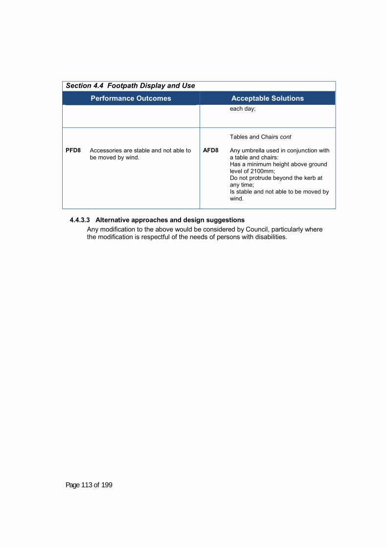
Page 113 of 199
Section 4.4 Footpath Display and Use
Performance Outcomes
Acceptable Solutions
each day;
PFD8
Accessories are stable and not able to be moved by wind.
AFD8
Tables and Chairs cont Any umbrella used in conjunction with a table and chairs: Has a minimum height above ground level of 2100mm; Do not protrude beyond the kerb at any time; Is stable and not able to be moved by wind.
4.4.3.3 Alternative approaches and design suggestions Any modification to the above would be considered by Council, particularly where the modification is respectful of the needs of persons with disabilities.

Page 114 of 199
Section 4.4 Footpath Display and Use (continued)
4.4.4 Goods and charity bins
4.4.4.1 Objectives a) To permit the display of goods and location of charity bins in a way that
preserves the access function of the footpath, preserves cleanliness and tidiness, and maintains visual amenity outside of operating hours.
4.4.4.2 Performance Outcomes and Acceptable Solutions Section 4.4 Footpath Display and Use
Performance Outcomes
Acceptable Solutions
PFD9 PFD10 PFD11 PFD12
Goods or charity bins displayed are clearly associated with the premises to which they relate; Goods or charity bins displayed are located so as to maintain pedestrian access along footpaths while complying with disability legislation; Goods or charity bins displayed present a professional appearance; Display stands are stable and not able to be moved by wind.
AFD9.1 AFD10.1 AFD10.2 AFD11 AFD12.1 AFD12.2 AFD12.3 AFD12.4
Goods for display or sale are only placed outside the premises to which they relate and only at such times during which those premises are open to the public; Charity bin provision, and placement thereof, does not exceed one (1) per establishment seeking to provide such an item. Goods or charity bins shall not encroach onto the footpath by more than one (1) metre; Displays do not exceed 1100mm in height for general goods and 1500mm for clothes racks; Goods for display or sale are not affixed to any premises, footpath, parking control sign, street furniture or pole; Display stands for goods are - of stable construction; • have no part protruding beyond the
main body of the stand; and • are placed so as to prevent them
being moved by wind or other forces.
Note: Clothes racks are prevented from movement either by locked wheels or a solid frame. Where the goods displayed are foodstuffs they are placed at a minimum height of 750mm above the footpath; Foodstuffs are packed in durable dustproof, weatherproof and tamper proof containers;

Page 115 of 199
4.4.4.3 Alternative approaches and design suggestions N/A.

Page 116 of 199
Section 4.5. Spray Drift (Applies to all zones and all residential development within the vicinity of an existing or proposed horticultural activity).
4.5.1 New residential development
4.5.2 Objectives a) To ensure that new development for residential purposes respects the
existing horticultural industry, in particular orchards and vineyards so as to: (i) Minimise nuisance to adjoining owners, and (ii) To protect the horticultural industries from encroaching development.
4.5.3 Performance Outcomes and Acceptable Solutions Section 4.5 Spray Drift
Performance Outcomes
Acceptable Solutions
PSD1 PSD2
New dwellings are provided with an adequate buffer (either by way of distance alone, or distance in conjunction with a vegetative screen) such that spray drift effects from existing orchards and vineyards are minimized; New dwellings do not depend on land within a different ownership for the provision of buffers.
ASD1.1 ASD1.2
New dwellings in the Primary Production Zone (RU1) are not located within 150m of an existing orchard or vineyard on land within a different ownership, or within 75m of an existing orchard or vineyard on land in the same ownership; New dwellings within the Rural Smallholdings Zone (RU4) are not located within 75m of an existing orchard or vineyard.
4.5.4 Alternative approaches and design suggestions Dwellings may be considered within 75m but no more than 40m from an existing orchard or vineyard provided that a tree buffer is planted incorporating two rows of trees, of an approved species, such rows being staggered and spaced to as to produce a continuous vegetative screen when the trees are at maturity. Note: Approved species include She Oak (Casuararina Cunninghammiama, Wattles (Meleloxylong, Hickory Wattle), Calistemon sp, Melaleuca sp, Leptospermum sp, Grevillia Ivanhoe).
Note: It is recognised that in some existing circumstances the above buffers may not be able to be achieved where existing residential lots are of insufficient size. In these cases the dwelling should be located as far as possible from the existing orchard or vineyard, and tree buffers of the type specified above are planted by the proponent of the residential dwelling.

Page 117 of 199
4.5.5 New horticultural development
4.5.6 Objectives a) To ensure that new development for horticultural purposes respects existing
dwellings so as to: (i) Minimise nuisance to residential dwellings; (ii) Protect the horticultural industries from conflict with adjoining
landholders; (iii) Facilitate the erection of dwellings on existing allotments with dwelling
rights.
4.5.7 Performance Outcomes and Acceptable Solutions Section 4.5 Spray Drift
Performance Outcomes
Acceptable Solutions
PSD3
PSD4
New horticultural developments are provided with an adequate buffer (either by way of distance alone, or distance in conjunction with a vegetative screen) such that spray drift effects to existing dwellings or potential dwelling sites are minimized; New horticultural developments do not depend on land in a different ownership for the provision of buffers.
ASD3.1 ASD3.2
New horticultural development within the Primary Production Zone (RU1) is not located within 150m of land within a different ownership, or within 75m of a dwelling on land in the same ownership; New horticultural development within the Rural Smallholdings Zone (RU4) is not located within 75m of land within a different ownership or a dwelling on land in the same ownership.
4.5.8 Alternative approaches and design suggestions New horticultural developments may be considered within 75m but not less than 40m from land within a different ownership or a dwelling on land in the same ownership provided that a tree buffer is planted incorporating two rows of trees, of an approved species, such rows being staggered and spaced to as to produce a continuous vegetative screen when the trees are at maturity. Note: Approved species include She Oak (Casuararina Cunninghammiama, Wattles (Meleloxylong, Hickory Wattle), Calistemon sp, Melaleuca sp, Leptospermum sp, Grevillia Ivanhoe).

Page 118 of 199
Section 4.6. Animal Boarding, Breeding or Training Establishments
(Applies to Zones RU1 and RU4)
Note: Consent requirements vary depending upon the number of animals. Wherever there is a business purpose, or animals are bred or trained for competition, consent is normally required. Non-business companion animals are considered on merit.
4.6.1 Objectives a) To ensure that these developments are well-located with respect to minimising
noise nuisance and visual impact.
4.6.2 Performance Outcomes and Acceptable Solutions
Section 4.6 Animal Boarding, Breeding or Training Establishments
Performance Outcomes
Acceptable Solutions
PAB1.1
PAB1.2 PAB1.3 PAB2 PAB3
Dog boarding and training establishments:
Are located on land of sufficient size to ensure that good acoustic buffers are available to any existing dwelling, or potential site of a new dwelling;
Do not create a nuisance by way of public health or odour;
Visually present in a manner so as to avoid long uninterrupted walls or fences. Catteries:
Horse training establishments:
AAB1.1.1
AAB1.1.2
AAB1.1.3 AAB1.2 AAB1.3
AAB2 AAB3.1 AAB3.2
Dog boarding and training establishments:
Are located at least 150 m from the boundary of an adjoining property; Provide any training tracks as far removed as practicable from existing dwellings on adjoining lands; Contain kennels and outdoor exercise areas within an enclosed space; Comply with the requirements of the Victorian Code of Practice for Dog Training Establishments or the NSW Animal Welfare Code of Practice No. 5 (for boarding establishments) as appropriate. Provide landscaping to screen any fence or wall longer than 15 m; Catteries:
Comply with the requirements of the NSW Animal Welfare Code of Practice No. 5 (for boarding establishments) as appropriate. Horse training establishments:
Are located at least 50 m from the boundary of adjoining property; Ensure that run off from any training ring or stables area is appropriately

Page 119 of 199
Section 4.6 Animal Boarding, Breeding or Training Establishments
Performance Outcomes
Acceptable Solutions treated through a water quality control facility before entering an adjoining property or watercourse;
4.6.3 Alternative approaches and design suggestions Alternative codes of practice or design guidelines would be considered on merit.

Page 120 of 199
Section 4.7. Bed and Breakfast and Farm Stay developments
4.7.1 Objectives a) To minimise the impacts on adjoining neighbours from Bed and Breakfast and
farm stay developments; b) To ensure these developments operate well from an internal design perspective.
4.7.2 Functional Statements a) Development is in-scale with surrounding development; b) Generation of noise is minimised; c) Overlooking of neighbouring properties is avoided; d) Signage is discreet; e) On-site parking is safe and convenient and provided at the rate outlined in
Section 4; f) Any changes to the building address neighbourhood character; g) The internal design provides clear "zones" for visitors only, owners only, and
shared spaces;
4.7.3 Performance Outcomes and Acceptable Solutions Section 4.7 Bed and Breakfast and Farm Stay Developments
Performance Outcomes
Acceptable Solutions PBB1 PBB2 PBB3
The development operates in a safe and healthy manner; The development operates within the capacity of existing services and facilities or these are upgraded appropriately; The development is of modest scale.
ABB1
ABB3
Comply with the NSW Local Government and Shires Associations Guidelines for Bed and Breakfast Operations, 1998; Guest rooms are limited to 3 rooms (Clause 5.4 of the Young LEP 2010).
4.7.4 Alternative approaches and design suggestions Alternative codes of practice or design guidelines would be considered on merit.

Page 121 of 199
Section 4.8. Use of Shipping Containers
4.8.1 General information The use of shipping containers for any purpose requires development consent unless the shipping containers are fully located within a building as part of an approved use or are part of the operation of the transport depot or related approved activity.
Note: The use to which the shipping container is to be put must be permissible use within the relevant zone, and be related to the predominant use of the land.
4.8.2 Objectives a) To ensure adequate amenity/streetscape protection when the installation of
shipping and/or storage containers are approved, b) To apply development controls through guidelines for the installation of
containers, c) To provide guidelines for the approval of shipping and/or storage containers.
4.8.3 Functional Statement a) The use of the container relates directly to and is ancillary to the predominant
approved use of the property. b) Containers are only to be used in conjunction with an approved use or
development on the land;
4.8.4 Performance Outcomes and Acceptable Solutions Section 4.8 Use of Shipping Containers
Performance Outcomes
Acceptable Solutions
PSC1
Permanent use of containers;
ASC1
Permanent use of containers; PSC1.1 PSC1.2
Containers are not visually intrusive when viewed from a public place or adjoining property; Containers are in good condition and are installed in a structurally stable manner;
ASC1.1.1 ASC1.1.2 ASC1.1.3 ASC1.2.1 ASC1.2.2 ASC1.2.3
Containers are fully screened from a public place and any adjoining property; Containers are not located within front or side setback distances (as provided for within the relevant zone); Containers are limited to two containers per property; Containers are free of major rust, are painted in a colour consistent with other development on the site; Are installed and tied down to a concrete slab or foundations capable of supporting the combined weight of the container and contents; Containers are placed on hard-stand
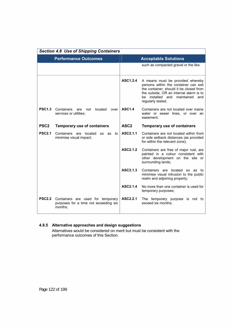
Page 122 of 199
Section 4.8 Use of Shipping Containers
Performance Outcomes
Acceptable Solutions
such as compacted gravel or the like.
PSC1.3
PSC2 PSC2.1 PSC2.2
Containers are not located over services or utilities; Temporary use of containers Containers are located so as to minimise visual impact; Containers are used for temporary purposes for a time not exceeding six months;
ASC1.2.4 ASC1.4
ASC2 ASC2.1.1 ASC2.1.2 ASC2.1.3 ASC2.1.4 ASC2.2.1
A means must be provided whereby persons within the container can exit the container, should it be closed from the outside, OR an internal alarm is to be installed and maintained and regularly tested. Containers are not located over mains water or sewer lines, or over an easement; Temporary use of containers Containers are not located within front or side setback distances (as provided for within the relevant zone); Containers are free of major rust, are painted in a colour consistent with other development on the site or surrounding lands; Containers are located so as to minimise visual intrusion to the public realm and adjoining property; No more than one container is used for temporary purposes; The temporary purpose is not to exceed six months;
4.8.5 Alternative approaches and design suggestions Alternatives would be considered on merit but must be consistent with the performance outcomes of this Section.
Page 123 of 199
Section 4.9. Restricted Premises and Sex Services Premises (Applies in the IN1 Zone)
4.9.1 Objectives The objectives of this section of the DCP are: a) To ensure restricted premises and sex service premises are appropriately
located to minimise offence to the community and mitigate any adverse social impacts;
b) To ensure that access to these premises is safe for patrons and staff; c) To ensure that these premises are designed to minimise the impact and
presence of the development in the locality; d) To ensure that these premises operate at times where they will have least
impact on the community and surrounding neighbourhood; and
Note: that Council may give consideration to a time-limited consent, in the circumstances of the case, in particular where Council is of the opinion that a limited period of operation is necessary to fully assess whether a sex service premises or restricted premises could operate in a satisfactory manner. Within this period the applicant shall be entitled to seek an amendment under Section 96(2) of the Environmental Planning and Assessment Act 1979 to allow an extension to the operation of the brothel. Council may then decide to either allow the sex services premises or restricted premises to operate for a further period or decline to amend the period of operation, in which case the sex services premises or restricted premises shall cease operation on the expiration of the consent.
4.9.2 Additional Information
The following additional information must accompany any development application for a sex service premises or restricted premises:
4.9.3 Plan Information a) A fully dimensioned Location Plan, drawn to scale, showing proximity and
location to nearby churches, schools, community facilities, hospitals, bus stops, parks and recreation facilities used by children, such as amusement arcades, sporting fields etc and distance from any residential zone or from properties used or partly used or capable of being lawfully used for residential purposes (other than ancillary dwellings); and • Type of land uses carried out on adjacent and nearby properties; and • The location of any other sex services premises or restricted premises
in the vicinity; b) A Floor Plan and Elevation Plans of the building drawn to scale which
indicates the proposed use of each room and shows compliance with the Building Code of Australia and the Disability Discrimination Act 1992; and
c) Entrances to and exits from the site; and d) The exterior colour scheme of the proposed development; and e) Details of the existing and proposed external lighting.

Page 124 of 199
4.9.4 Performance Outcomes and Acceptable Solutions Section 4.9 Restricted Premises and Sex Services Premises
Performance Outcomes
Acceptable Solutions
PRP1
PRP2
PRP3 PRP4 PRP5 PRP6
Sex service premises or restricted premises are not located in such concentration (either alone or in combination with other sex-related businesses) as to result in the creation of a "red light" district; Access to or from a sex service premises or restricted premises is not near or within view from a church, hospital, bus stop, school or any place frequented by children for recreational or cultural activities; Patrons of sex service premises or restricted premises do not loiter outside the premises; Access to the premises is clearly illuminated in order to discourage loitering and to ensure the safety of patrons and staff; Sex service premises or restricted premises are designed to be compatible with the built form of adjacent premises; Disabled persons are able to comfortably access the development.
ARP1.1 ARP1.2 ARP2.1 ARP2.2 ARP2.3 ARP4
ARP6
is not located within 100 metres access (pedestrian shed) of any other sex service premises or restricted premises; is not be located in or adjoining licensed premises, motels, boarding or guest houses; is not located within a 150 metre access (pedestrian shed) of existing dwellings and hospitals; is not located within a 200 metre access (pedestrian shed) from churches, schools, recreation areas and childcare centres; does not adjoin a residential flat, a residential flat building, an activity operated by a religious institution, a restaurant, a supermarket, a video shop, or amusement parlours and/or arcades; provides outdoor lighting; provides access for disabled persons is provided to the development in accordance with the Disability Discrimination Act, 1992 and the Building Code of Australia.

Page 125 of 199

Page 126 of 199
Additionally, a sex service premises;
(i) is not in a “shop front” premises; (ii) does not contain more than 4 separate rooms for the purposes of sex
services; (iii) is provided with a waiting room of at least 20 square metres in size; (iv) The sex service premises is fitted with the necessary facilities and
services for Class 6 buildings under the Building Code of Australia; (v) has all windows are covered with blinds or curtains at all times; (vi) complies with the Department of Local Government guidelines for sex
services premises.
Note: these guidelines should be considered in the preparation of any development application. Council would condition any consent to be fully compliant with these guidelines.

Page 127 of 199
Chapter 5. Subdivision Development
Section 5.1. Subdivision in the Rural Zones RU1, RU4 and E3.
5.1.1 Objectives a) To ensure that access arrangements are appropriate for the type of rural
subdivision;
5.1.2 Functional Statement a) Lots are provided with appropriate services; b) Constraint-free building envelopes are available; c) The use of rights-of-carriageway is minimised.
5.1.3 Performance Outcomes and Acceptable Solutions Section 5.1 Subdivision in the Rural Zones RU1, RU4 and E3
Performance Outcomes
Acceptable Solutions
PSD1.1 PSD1.2
All created allotments have legal and practical access including alternative emergency access as may be required by the development; Adequate physical access is available to a new allotment, being an allotment created for agricultural purposes or of sufficient size so as to have the right to apply for a dwelling;
ASD1.1 ASD1.2.1
Each allotment created has legal access to a public road or Crown Road (duly formed or upgraded for the purpose) either through direct frontage, a right-of-way arrangement, or by consolidation with an existing allotment that has such access; For lots created for agricultural purposes:
a) A right as to user is provided on the title to any allotment created for agricultural purposes (that does not have constructed physical access provided or already available at the time of creation) to require the construction of such access at such time as the allotment is no longer in the same ownership as a directly abutting allotment; and
b) Any such access is constructed
prior to transfer of title, and consists of a recessed gate (sufficient that an articulated vehicle can stand clear of the road carriageway) OR a cattle grid TOGETHER WITH a piped crossing over the table drain constructed to Council’s Engineering Subdivision and

Page 128 of 199
Section 5.1 Subdivision in the Rural Zones RU1, RU4 and E3
Performance Outcomes
Acceptable Solutions
Development guidelines;
ASD1.2.2
ASD1.2.3
For lots created with the right to apply for a dwelling:
a) Access is provided to a non-classified road where possible, and in accordance with Council’s Engineering Subdivision and Development guidelines;
b) Where access to a classified road is necessary, this is provided in accordance with RTA standards for access to a rural dwelling;
c) Street numbering is provided in accordance with the rural addressing scheme;
d) Any electricity services are provided by way of overhead wiring;
e) Where land has been identified as former orchard or other potentially contaminate landuse, a report from a suitably qualified consultant is submitted to Council demonstrating that the land is suitable for the intended use;
f) Separation distances are consistent with Section 2.1.5 Table 2.1.
Standard of construction for roads built and roads fronted or other road network facilities are provided as part of the development application, such standards to incorporate: • Minimum formed road width 8m; • Minimum sealed carriageway width
7m;
Subdivisions exceeding 25 lots shall: have their main subdivision service road connect to the existing road network in at least two (2) locations.
Page 129 of 199
5.1.4 Design Suggestions and Variations Good design practice minimises the use of “right-of-carriageway”. Should a right of carriageway be employed, the following provisions apply.
Note: Rights-of-carriageway are strips of land over which one or more parcels of land enjoy certain right of access. Right-of-Carriageways are private agreements between individual owners of the parcels of land involved and Council does not have any responsibilities nor rights with regards to them. Council will require the approval of all owners of land over which a Right-of-Carriageway is proposed prior to a Development Application for subdivision being lodged. Construction and maintenance of a Right-of-Carriageway and associated access to the public road carriageway is not the responsibility of Council but is the full responsibility of the relevant landholders.
5.1.4.1 “Right-of-Carriageway” Requirements Any right of carriageway would service, at most, 2 allotments. It would be conditioned so as to require that access is maintained to a good trafficable standard suitable for two-wheel drive vehicles, and a notation is placed on the title of every benefitting lot such that maintenance of the right-of-carriageway is required, to the standard specified, with the cost being borne proportionally by each owner based on the distance of the access point of their allotment to the public road.

Page 130 of 199
Section 5.2. Subdivision in the General Residential Zone (R1) and Village Zone (RU5)
5.2.1 Objectives a) To ensure that land is developed in a manner that is appropriate to the existing or
preferred character of the area; b) To ensure that land is developed in a way that will minimise impacts on the
natural environment and will allow for the efficient and equitable distribution of public amenities and services.
5.2.2 Functional Statement a) Minimise the length of roadway and public services required to service the
subdivision, while complying with the other performance outcomes of this section; b) Ensure that a diverse range of lot sizes are available including allotments with
potential for dual occupancy or multi-unit housing; c) To ensure that lots are of a sufficient size and shape for the proposed and expected
use. d) Adequate safe area for building and access where the site is subject to constraints
such as flooding, subsidence, slip, bush fire or any other risk. e) Layouts which conserve any significant site features in environmentally sensitive
areas f) Layouts which contribute to the scenic quality, landscape and character of the locality g) Required building setbacks from front, side and rear boundaries; h) To ensure allotments are serviced with public utilities in accordance with the
requirements of the various authorities; i) To ensure that layouts consider Crime Prevention through Environmental Design
(CPTED) principles;
5.2.3 Performance Outcomes and Acceptable Solutions Section 5.2 Subdivision in the General Residential Zone (R1) and Village Zone (RU5)
Performance Outcomes
Acceptable Solutions
To ensure that subdivision layouts:
Subdivision layouts:
PSD2.1 PSD2.2 PSD2.3
All intersections shall be designed for safe traffic management; Minimise the use of cul-de-sacs, and where these are provided provide adequate minimum frontages to facilitate reasonable access and dwelling construction; Provide road widths that are consistent with the character of the Young Township or the village concerned, within a logical hierarchy
ASD2.1 ASD2.2 ASD2.3.1
Avoid four-way intersections, and provide a minimum spacing between intersections of 40m (may be 20m for minor access roads and cul de sacs); Avoid cul-de-sacs if possible; Provide minimum road carriageway widths as follows: • Cul-de-sac or minor access road
(up to 15 dwellings) – 9m
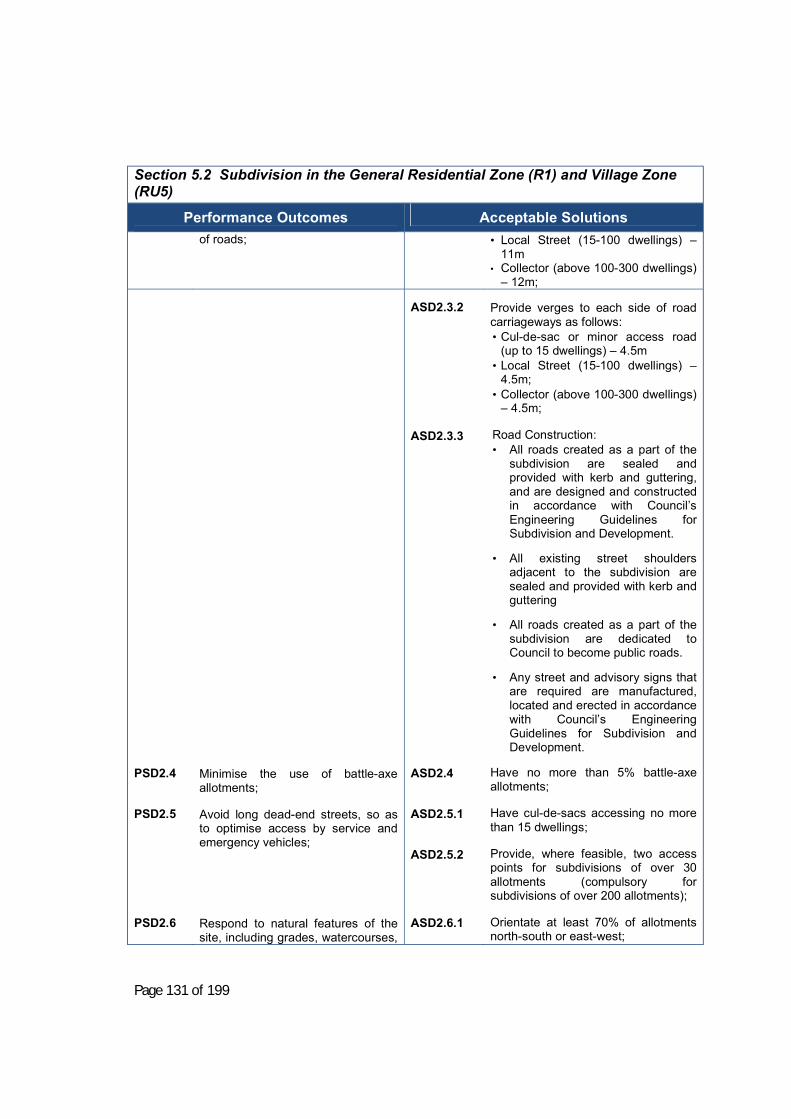
Page 131 of 199
Section 5.2 Subdivision in the General Residential Zone (R1) and Village Zone (RU5)
Performance Outcomes
Acceptable Solutions
of roads;
• Local Street (15-100 dwellings) – 11m
• Collector (above 100-300 dwellings) – 12m;
PSD2.4 PSD2.5 PSD2.6
Minimise the use of battle-axe allotments; Avoid long dead-end streets, so as to optimise access by service and emergency vehicles; Respond to natural features of the site, including grades, watercourses,
ASD2.3.2 ASD2.3.3 ASD2.4 ASD2.5.1 ASD2.5.2
ASD2.6.1
Provide verges to each side of road carriageways as follows: • Cul-de-sac or minor access road
(up to 15 dwellings) – 4.5m • Local Street (15-100 dwellings) –
4.5m; • Collector (above 100-300 dwellings)
– 4.5m;
Road Construction: • All roads created as a part of the
subdivision are sealed and provided with kerb and guttering, and are designed and constructed in accordance with Council’s Engineering Guidelines for Subdivision and Development.
• All existing street shoulders adjacent to the subdivision are sealed and provided with kerb and guttering
• All roads created as a part of the
subdivision are dedicated to Council to become public roads.
• Any street and advisory signs that are required are manufactured, located and erected in accordance with Council’s Engineering Guidelines for Subdivision and Development.
Have no more than 5% battle-axe allotments; Have cul-de-sacs accessing no more than 15 dwellings; Provide, where feasible, two access points for subdivisions of over 30 allotments (compulsory for subdivisions of over 200 allotments); Orientate at least 70% of allotments north-south or east-west;

Page 132 of 199
Section 5.2 Subdivision in the General Residential Zone (R1) and Village Zone (RU5)
Performance Outcomes
Acceptable Solutions aspect and soil types;
ASD2.6.2 ASD2.6.3
Provide larger allotments on south-facing slopes; Provide a minimum lot width of 20m where cross-grades of allotments exceed 10%, or where lots are east-west;
PSD2.7 PSD2.8 PSD2.9.1 PSD2.9.2 PSD2.9.3 PSD2.9.4 PSD2.9.5
Provide, where necessary, public open space of usable size, grades and shape, conveniently located to serve the residents of the subdivision OR alternatively contribute to the upgrading of public open space in the vicinity and/or access to that space in accordance with any contributions plan that may be in force; Locate building envelopes so that there is an equitable distribution of views; To ensure that Site Design (undeveloped allotments) provides for; An energy efficient dwelling house and any ancillary buildings and facilities Outdoor landscaping and recreation space Outdoor service space Onsite car parking Buffering allowance from sensitive or offensive uses
ASD2.6.4
ASD2.7.1 ASD2.7.2 ASD2.8.1
PSD2.9.1 PSD2.9.2
Where terracing of cross-grade lots is required to provide level building envelopes, such terracing is provided by the developer, with the engineering design of retaining walls certified by an experienced practicing structural engineer and the geotechnical stability of sites is certified by a qualified and experienced geotechnical engineer; Maintain natural watercourses and incorporate within open space areas; Provide 10% of land as public open space for subdivisions of 30 allotments or more, or, alternatively contribute an equivalent amount (costed at residential land value) for open space purchase and/or embellishment and/or access to open space in the vicinity; Arrange layout so as to maximise access to existing views for both existing and proposed allotments; Site Design An average lot size of 700m2 and a minimum lot size of 650m2 is achieved or exceeded; All allotments can accommodate a building envelope of 16m x 9m; such building envelope to be no closer than 1m to any side or rear boundary, or 6m to the front boundary, and located so that an 8m high dwelling on the envelope would not overshadow an existing dwelling so as to overshadow more than 50% of their private open space or north-facing roof between

Page 133 of 199
Section 5.2 Subdivision in the General Residential Zone (R1) and Village Zone (RU5)
Performance Outcomes
Acceptable Solutions
9am and 3pm on 21st June; Note: Building envelopes need not be implemented by way of an 88B instrument, however if the developer chooses to do so, such restriction will be endorsed by Council;
PSD2.10 PSD2.11
Vehicular access is provided to and from the site Servicing Site servicing, including any easements that may be required, and disposal of sewage and waste water
ASD2.9.3 ASD2.9.4 ASD2.10 ASD2.11.1 ASD2.11.2 ASD2.11.3 ASD2.11.4
At least 70% of allotments are oriented within 15 degrees of north-south or east-west, with the majority of allotments being oriented north-south; All allotments have a minimum width of 18m at a point 6m back from the front boundary except east-west orientated lots (i.e. within 15 degrees of east-west) which have a minimum width of 20m at that same point; Where battle-axe allotments are provided, no more than two such allotments may be serviced by a shared driveway; Servicing Power is provided in the form of underground services, in accordance with Country Energy Requirements; Street lighting is provided in accordance with the requirements of Country Energy; A layback is provided to each allotment created, consistent with the parking and access chapter of this DCP OR roll-over kerb is provided. All allotments created are provided with a sewer connection, the connection to which is designed and constructed in accordance with Council’s Engineering Guidelines for Subdivision and Development OR where sewer is not available, are able to satisfy the requirements of

Page 134 of 199
Section 5.2 Subdivision in the General Residential Zone (R1) and Village Zone (RU5)
Performance Outcomes
Acceptable Solutions ASD2.11.5
Council’s On Site Management Plan for waste water disposal. All allotments created are provided with a connection point to Council’s water mains, the connection to which is designed and constructed in accordance with Council’s Engineering Guidelines for Subdivision and Development.
ASD2.11.6 ASD2.11.7 ASD2.11.8 ASD2.11.9 ASD2.11.10
All allotments created are drained directly to the street drainage system or to receiving waters OR are drained to the street system or receiving waters via an inter-allotment drainage system constructed in accordance with Council’s Engineering Guidelines for Subdivision and Development. Note: inter-allotment drainage would be required for all allotments with a cross-fall where any portion of the allotment drains through an adjoining allotment, or where the allotment drains away from the street; Written confirmation is provided by a telecommunications carrier stating that facilities are available to each allotment or that otherwise suitable arrangements have been made. Written confirmation is provided by the natural gas company stating that facilities are available to each allotment or that otherwise suitable arrangements have been made. Easements are provided wherever necessary to permit unrestricted access for sewerage, water and drainage purposes. Note: easement widths provide at least 1m clear access either side of the facility protected by the easement. Development contributes, if required, headworks and/or development servicing plan charges. Note: Contact
Page 135 of 199
Section 5.2 Subdivision in the General Residential Zone (R1) and Village Zone (RU5)
Performance Outcomes
Acceptable Solutions should be made with Council’s Utilities Services Division to determine these charges, which are payable prior to the release of any Construction Certificate.
5.2.4 Design Suggestions and Variations If cul-de-sacs are included within the development, these need to be as short as practicable and needed to provide turning facilities to cater for a 12.5 m truck. These turning facilities can include a "bulb" cul-de-sac head, of the size so as to permit the design vehicle to turn without backing while still leaving kerbside space for parked cars or may also include a “Y” or “T” head facility designed to cater for the design vehicle. Note: Care and attention to property access is required if “Y” or “T” facilities are to be used.

Page 136 of 199
Section 5.3. Subdivision in the Large Lot Residential Zone (R5)
5.3.1 Objectives a) To ensure that large lot residential allotments function effectively for residential
lifestyle purposes, and are developed in a way that provides for future re-subdivision;
5.3.2 Performance Outcomes and Acceptable Solutions Section 5.3 Subdivision in the Large Lot Residential Zone (R5)
Performance Outcomes
Acceptable Solutions
PSD3.1 PSD3.2 PSD3.1
To provide for lifestyle allotments that are capable, should future demand require, of being efficiently re-subdivided into standard residential allotments; To ensure that roads are constructed to a standard that is durable and suitable for the proposed development, and which are capable of being upgraded to serve standard residential allotments. Site Design: To provide for lifestyle allotments that are capable, should future demand require, of being efficiently re-subdivided into standard residential allotments;
ASD3.1.1 ASD3.1.2 ASD3.1.3 ASD3.2.1 ASD3.1.4 ASD3.1.5
Subdivision Layout Has at least one connection point to an existing public road; Provides for future road connectivity to adjoining development sites; Provides a connection point or potential future connection point to all public roads adjoining the development site; Provides road reserves of at least 19m in width, and road carriageways of at least 8m in width; Site Design: Allotments have a minimum frontage and width of 90 m; A MasterPlan overlay is provided demonstrating re-subdivision is feasible in accordance with the requirements for the R1 zone, and which • identifies (and protects by a
restriction as to user) a potential future road corridor that would permit the resubdivision of the allotment at a future time for standard residential purposes;
• identifies building envelopes that would permit the resubdivision of

Page 137 of 199
Section 5.3 Subdivision in the Large Lot Residential Zone (R5)
Performance Outcomes
Acceptable Solutions the allotment at a future time for standard residential purposes, including a nominated building envelope for the initial dwelling;
PSD3.2
ASD3.1
To ensure that roads are constructed to a standard that is durable and suitable for the proposed development, and which are capable of being upgraded to serve standard residential allotments. Servicing: To provide for lifestyle allotments that are capable, should future demand require, of being efficiently re-subdivided into standard residential allotments;
ASD3.2.2 ASD3.1.6 ASD3.1.7 ASD3.1.8
• provide side setbacks that are
consistent with the future resubdivision of the allotment for standard residential purposes.
Road Construction: • All roads created as a part of the
subdivision are sealed and are designed and constructed in accordance with Council’s Engineering Guidelines for Subdivision and Development.
• Carriageway edges are stabilised using a concrete boundary strip, dish drain or rollover kerb;
• Drainage swales to roadways (where required) are provided with a low flow pipe to Council’s Engineering Department’s specifications and are graded so as to permit mowing with a gang mower, or similar;
• All roads created as a part of the subdivision are dedicated to Council to become public roads.
• Any street and advisory signs that are required are manufactured, located and erected in accordance with Council’s Engineering Guidelines for Subdivision and Development.
Servicing: Power is provided in the form of underground services, in accordance with relevant electricity authority requirements. Allotments created are provided with reticulated water a sewer connection, the connection to which is designed and constructed in accordance with Council’s Engineering Guidelines for Subdivision and Development; All allotments created are provided
Page 138 of 199
Section 5.3 Subdivision in the Large Lot Residential Zone (R5)
Performance Outcomes
Acceptable Solutions with a connection point to Council’s water mains, the connection to which is designed and constructed in accordance with Council’s Engineering Guidelines for Subdivision and Development.
ASD3.1.9 ASD 3.1.10 ASD 3.1.11
Servicing cont Written confirmation is provided by a telecommunications carrier stating that facilities are available to each allotment or that otherwise suitable arrangements have been made. Easements are provided wherever necessary to permit unrestricted access for sewerage, water and drainage purposes. Note: easement widths are a minimum of 4m wide and provide at least 1m clear access either side of the facility protected by the easement. Development contributes, if required, headworks and/or development servicing plan charges. Note: Contact should be made with Council’s Utilities Services Division to determine these charges, which are payable prior to the release of any Construction Certificate.
5.3.3 Design Suggestions and Variations Alternative approaches will be considered on merit.

Page 139 of 199
Section 5.4. Industrial Subdivision
5.4.1 Objectives a) To ensure that industrial allotments function effectively for industrial purposes.
5.4.2 Performance Outcomes and Acceptable Solutions
Section 5.4 Industrial Subdivision
Performance Outcomes
Acceptable Solutions
PSD4.1 PSD4.2 PSD4.3
To achieve width/depth ratios for new industrial allotments that respond to typical industrial building forms and which ensure heavy vehicles can adequately manoeuvre on site; To ensure that roads are constructed to a standard that is durable and suitable for the proposed use. Servicing:
ASD4.1 ASD4.2 ASD4.3.1
Industrial allotments: • Have a minimum frontage and square
width of 24 m, and a minimum area of 2000 m².
• Are of regular size and shape with a depth to width ratio not exceeding 3:1.
• Are serviced by underground electricity, water, sewer and telecommunications in accordance with the relevant authorities’ requirements.
Roadways created to serve an industrial subdivision: • Have a minimum road reserve width of
25m (for roads with dual frontage) or 19m (for roads with single frontage);
• Have a minimum carriageway width of 13m;
• Avoid, where practicable, dead-end roads, however if these are provided, a minimum turning head of 25m is provided;
• Are constructed in accordance with Council’s Engineering Subdivision and Development Guidelines.
Servicing: • Water, sewer and power are provided,
in accordance with the relevant authorities requirements and in accordance with Council’s Engineering Subdivision and Development Guidelines; Note: Underground power is required for these developments.
• Development contributes, if required, headworks and/or development servicing plan charges. Note: Contact should be made with Council’s Utilities Services Division to determine these charges, which are payable prior to the release of any Construction Certificate.

Page 140 of 199
5.4.3 Design Suggestions and Variations Alternative approaches will be considered on merit.