Changes in pore size distribution and hydraulic properties of forest soil resulting from structural...
18
Changes in pore size distribution and hydraulic properties of forest soil resulting from structural development Yuki Hayashi * , Kosugi Ken’ichirou, Takahisa Mizuyama Laboratory of Erosion Control, Division of Forest and Biomaterials Science, Graduate School of Agriculture, Kyoto University, Kitashirakawa, Oiwakecho, Sakyo-ward, Kyoto 606-8502, Japan Received 8 December 2005; received in revised form 9 May 2006; accepted 10 May 2006 Summary To examine how rainwater dynamics on a forested hillslope change as a result of forest biological activities altering the development of pore structure, we analyzed the pore size distributions and hydraulic properties of forest soils under disturbed and undisturbed con- ditions. Undisturbed soil samples were collected in nine forests on Mt. Rokkou and Sakurajima Island, Japan, and disturbed soil samples were prepared using the same samples. We measured water retention curves, saturated hydraulic conductivities, and particle size distributions. Results showed that while pore size distributions and saturated hydraulic conductivities of dis- turbed soils were mainly influenced by particle size distributions, undisturbed forest soils had relatively similar pore size distributions and saturated hydraulic conductivities after secondary soil pores were formed as a result of forest biological activities. The undisturbed forest soils contained more large pores and fewer intermediate-size pores than the disturbed soils. We also found that undisturbed forest soils had a higher water content than the disturbed soils. As sec- ondary soil pores developed, the median pore radius and the width of the pore size distribution increased, and the soil water diffusivity tended to decrease. The saturated hydraulic conduc- tivity was proportional to the square of the median pore radius for all samples. Numerical sim- ulations conducted assuming the mean hydraulic properties for disturbed and undisturbed soils revealed that the development of soil structure in forest soils has the effect of decreasing storm runoff and increasing base flow discharge. c 2006 Published by Elsevier B.V. KEYWORDS Forest soil; Pore size distribution; Water retention curve; Hydraulic conductivity; Structure development Introduction The study of rainwater dynamics on forested hillslopes is a very important area of research in forest hydrology. To eval- 0022-1694/$ - see front matter c 2006 Published by Elsevier B.V. doi:10.1016/j.jhydrol.2006.05.003 * Corresponding author. Tel.: +81 75 753 6493; fax: +81 75 753 6088. E-mail address: [email protected] (Y. Hayashi). Journal of Hydrology (2006) 331, 85– 102 available at www.sciencedirect.com journal homepage: www.elsevier.com/locate/jhydrol
-
Upload
yuki-hayashi -
Category
Documents
-
view
213 -
download
0
Transcript of Changes in pore size distribution and hydraulic properties of forest soil resulting from structural...

Journal of Hydrology (2006) 331, 85–102
ava i lab le a t www.sc iencedi rec t . com
journal homepage: www.elsevier .com/ locate / jhydrol
Changes in pore size distribution andhydraulic properties of forest soil resultingfrom structural development
Yuki Hayashi *, Kosugi Ken’ichirou, Takahisa Mizuyama
Laboratory of Erosion Control, Division of Forest and Biomaterials Science, Graduate School of Agriculture,Kyoto University, Kitashirakawa, Oiwakecho, Sakyo-ward, Kyoto 606-8502, Japan
Received 8 December 2005; received in revised form 9 May 2006; accepted 10 May 2006
Summary To examine how rainwater dynamics on a forested hillslope change as a result offorest biological activities altering the development of pore structure, we analyzed the poresize distributions and hydraulic properties of forest soils under disturbed and undisturbed con-ditions. Undisturbed soil samples were collected in nine forests on Mt. Rokkou and SakurajimaIsland, Japan, and disturbed soil samples were prepared using the same samples. We measuredwater retention curves, saturated hydraulic conductivities, and particle size distributions.Results showed that while pore size distributions and saturated hydraulic conductivities of dis-turbed soils were mainly influenced by particle size distributions, undisturbed forest soils hadrelatively similar pore size distributions and saturated hydraulic conductivities after secondarysoil pores were formed as a result of forest biological activities. The undisturbed forest soilscontained more large pores and fewer intermediate-size pores than the disturbed soils. We alsofound that undisturbed forest soils had a higher water content than the disturbed soils. As sec-ondary soil pores developed, the median pore radius and the width of the pore size distributionincreased, and the soil water diffusivity tended to decrease. The saturated hydraulic conduc-tivity was proportional to the square of the median pore radius for all samples. Numerical sim-ulations conducted assuming the mean hydraulic properties for disturbed and undisturbed soilsrevealed that the development of soil structure in forest soils has the effect of decreasingstorm runoff and increasing base flow discharge.
�c 2006 Published by Elsevier B.V.
KEYWORDSForest soil;Pore size distribution;Water retention curve;Hydraulic conductivity;Structure development
0d
6
022-1694/$ - see front matter �c 2006 Published by Elsevier B.V.oi:10.1016/j.jhydrol.2006.05.003
* Corresponding author. Tel.: +81 75 753 6493; fax: +81 75 753088.E-mail address: [email protected] (Y. Hayashi).
Introduction
The study of rainwater dynamics on forested hillslopes is avery important area of research in forest hydrology. To eval-
86 Y. Hayashi et al.
uate the effects of the forest on flood mitigation and waterresources, observation and modeling of rainwater infiltra-tion and discharge processes are necessary for predictingdischarge hydrographs (Sherman, 1932; Todini, 1988). Rain-water infiltration produces positive pore water pressures insoil layers and is closely related to the occurrence of slopefailures (e.g., Bishop, 1955). In addition, knowledge of themoisture content and water movement in a soil layer is fun-damental to the analysis of biological reactions, plant activ-ity, material transports in forest ecosystems, and streamwater chemistry (Sklash and Farvolden, 1979; Pinder andJones, 1969).
Previous studies have indicated that Hortonian overlandflow does not usually occur on forested hillslopes, becauseforest soils, which contain many large pores, usually havehigher permeability than is needed to absorb rain fallingat normal intensity (e.g., Hewlett, 1961a,b; Dunne andBlack, 1970; Ohta et al., 1989; Ohte et al., 1989; Tsukam-oto, 1992). Therefore, to describe water circulation on aforested hillslope, it is insufficient simply to analyze thepermeability of forest soils; studies of the behavior of infil-trated rainwater are also required. These analyses requireinformation on unsaturated soil hydraulic properties suchas water retention characteristics and unsaturated hydrau-lic conductivity. However, relatively little is known aboutthe unsaturated hydraulic properties of forest soils com-pared to saturated properties, such as total porosity andsaturated hydraulic conductivity.
Field soils usually contain a basic primary pore system,which is determined by solid particle-size distribution andparticle arrangements, accompanied by a secondary poresystem formed by the effects of biological activities (Mar-tin, 1945; Soil Survey Staff, 1951). In forest soils, the devel-opment of the secondary pore system is greatly affected bybiological activities in the forest ecosystem (Coile, 1952).Analyzing retention curves obtained from about 200 soils,Kosugi (1997a) found that undisturbed forest soils havegreater median pore radii than disturbed loamy soils and agreater width of pore size distribution than disturbed sandysoils. His study also showed that the pore size distributionsof forest soils are related to soil structure more closely thanto soil texture; crumb-structured forest soils have greatermedian values and width of pore size distribution thangranular-structured forest soils, and massive forest soilshave smaller median values than the crumb and granular-structured soils. However, Kosugi (1997a) only analyzedretention data sets for disturbed or undisturbed soilscollected from previous studies and did not clarify howthe formation of the secondary pore system affected thepore size distribution and hydraulic properties of each for-est soil. The effects of the secondary pores formed by forestbiological activities may be evaluated by comparing thehydraulic properties of the same sample measured underundisturbed and disturbed conditions.
Most previous studies that have evaluated the effects ofsoil structural changes on soil hydraulic properties havemainly analyzed anthropogenic effects on soils in agricul-tural fields. For example, Anderson et al. (1990) comparedsoils with and without manure fertilization at a rate of13.5 t ha�1 y�1 over a period of 100 years and found thatthe fertilizer treatment increased saturated hydraulic con-ductivity and the proportions of pores with diameters
>1000 lm. Garnier et al. (2004) measured retention curvesand saturated hydraulic conductivities of packed soils con-taining various proportions of straw (from 0 to0.3 cm3 cm�3) and showed that the saturated hydraulic con-ductivity decreased and water content at a given matric po-tential increased with increasing straw content. Rachmanet al. (2004) compared soils within and away from a grasshedge area and reported that soils within the grass hedgearea had lower bulk densities and higher saturated hydraulicconductivities. Mohawesh et al. (2005) studied soils in a cas-sava plantation that ranged in bulk density from 1.15 to1.4 g cm�3. Their results showed that as the bulk density in-creased, the saturated water content decreased, and aninflection point on the retention curve shifted to a lowermatric potential. Recent study by Tuli et al. (2005) com-pared air and water permeability between undisturbedand repacked soils collected at an agricultural field. Theyshowed that the air and water permeability of undisturbedsamples were significantly higher than those of disturbedsamples, due to major role of soil structure and macroporeflow on permeability.
Some studies have also reported anthropogenic effectson the hydraulic properties of forest soils. For example,Starsev and McNabb (2001) investigated the effects of skid-der operations on poorly structured medium-textured bor-eal forest soil. Compaction by the skidder flattened thewater retention curves in the high matric potential range,shifted an inflection point to a lower matric potential, anddecreased air-filled porosity. Ohnuki et al. (2004) compareddeposited soil eroded from logging roads and skid trails tonatural forest soil and found that natural forest soil hadmore pores in the high matric potential range. Shestakand Busse (2005) analyzed the effects of compaction on in-tact forest soils and showed that the proportion of pores>30 lm in diameter decreased and that of pores <0.2 lmin diameter increased. However, these studies examinedsoils only at individual study sites, focusing on individualanthropogenic effects. Hence, they did not adequately clar-ify general trends of how forest biological activities affectthe formation of secondary pore systems, and how theychange the hydraulic properties of forest soils. We haveno comprehensive understanding of the effects of secondarypore formation on rainwater infiltration and drainage pro-cesses on forested hillslopes, beyond an appreciation thatincreased permeability reduces the occurrence of Hortonianoverland flow.
Among the few studies that have compared hydraulicproperties measured under undisturbed conditions to thosemeasured under disturbed conditions for the same forestsoil, Kosugi (1994) analyzed data sets of four samples mea-sured by Ohte (1992) and reported that the median pore-size distribution increased with the development of soilstructure, which was affected by forest biological activities.However, the number of samples was limited, and the gen-eral trends of how pore-size distributions and hydraulicproperties of forest soils change under biological influencesremain unclear.
With this background, the objectives our study were toclarify the changes in pore structure and hydraulic proper-ties of forest soils as a result of biological activities and toexamine how rainwater dynamics on a forested hillslopechange as a result of pore structure development. We used

Changes in pore size distribution and hydraulic properties of forest soil resulting from structural development 87
the same method to analyze various forest soils, which werecharacterized by different geological characteristics andparticle size distributions. Hydraulic properties observedfor each undisturbed sample were compared to those ob-served for a disturbed sample of the same soil. We discussthe effects of pore structure development resulting fromforest biological activities on the saturated hydraulic con-ductivities, pore size distributions, parameters of a reten-tion model, functions describing soil hydraulic properties,and rainwater infiltration and drainage processes on a for-ested hillslope.
Materials and methods
Sampling sites
We investigated forest soils developed from two geologi-cally different parent materials, i.e., weathered graniteand volcanic ash. Weathered granite soil samples were col-lected at Mt. Rokkou (34�46 0N, 135�16 0E), Hyogo Prefecture,Japan (Fig. 1). This area has a mean annual temperature of15 �C, precipitation of 1600 mm, maximum snow depth of10 cm, and 10 days of snow cover per year. Volcanic ash soilsamples were collected from the volcanic island of Sakuraj-ima (31�36 0N, 130�38 0E), Kagoshima Prefecture, Japan,which has a mean annual temperature of 19 �C, precipita-tion of 2300 mm, and no snow cover days. Sakurajima isone of the most active volcanoes in Japan; its eruptionhas created ash deposits around the source area in ravines,and forests have developed on these ash deposits. We se-lected six soil-sampling sites on Mt. Rokkou (R1–R6 inFig. 1) and three sites on Sakurajima (S1–S3 in Fig. 1). Table1 provides descriptions of the sampling sites.
Mt. Rokkou was denuded of all tree cover about 90 yearsbefore our study, as a result of excess timber harvesting andthe removal of forest litter for fuel and fertilizer. Revegeta-tion work has been carried out over the last 90 years to pre-vent soil erosion. Consequently, most of this area has beenrecently covered with artificial forests. Both R1 and R2 wereplantations of Japanese cypress (Chamaecyparis obtusa),which is one of the most useful tree species for timber pro-
Figure 1 Location and topogra
duction. While R2 consisted mainly of cypress, some broad-leaved trees were also present at R1. R2 had a dense coverwith an A0-layer consisting of slightly fermented cypress lit-ter, while the A0-layer cover was sparse at R1. At R3, nativetrees such as Quercus serrata, Q. salicina, and Cleyerajaponica were planted in the spring of 2001 after Robiniapseudoacacia, which had been planted for revegetationabout 60 years ago, was removed in the fall of 2000. SitesR4 and R5 were covered with semi-natural forests in whichthe dominant species varied with altitude; R4 was predom-inantly beech (Fagus japonica) and R5 was mostly oak (Q.serrata). Sites R5 and R6 were located on a ridge. At R6,vegetation was dominated by Pinus densiflora Sieb. etZucc., which is classified as a pioneer tree requiring highlevels of solar radiation but less soil moisture and nutrients.The soil at Mt. Rokkou is brown forest soil, classified as aCambisol. The total soil depth and depths of the A and Bhorizons at each sampling site are summarized in Table 1.Plant roots were found both in the A and B horizons, exceptat R1.
Soils on Sakurajima were black soils, classified as Ando-sols. Site S1 was covered with an artificially planted forestof pine (Pinus thunbergii). Both S2 and S3 were covered withsemi-natural forests. Site S2 was a mixed stand consisting ofboth conifer and broadleaved trees, and broadleaved treeswere dominant at S3. While many fine roots were presentat S1 and S3, the organic forest floor was thin and rootswere sparse at S2.
Soil samples
We collected undisturbed soil samples from each samplingsite using thin-walled steel samplers with a volume of100 cm3 (5 cm inner diameter and 5.1 cm in height). Thesampler with a sharpened edge was inserted verticallyinto the soil. Impact energy was applied to the cylinderby using a hammer-driven device (DIK-1630, Daiki Rika Ko-gyo, Tokyo, Japan). To ensure sampling with minimumdisturbance, we followed the method for collecting undis-turbed soil samples described by Grossman and Reinsch(2002). During the process of insertion, roots and organic
phies of soil sampling sites.

Table 1 Characteristics of soil sampling sites
Samplingsite
Altitude(m)
Vegetation Forest floor Soil depth(cm)
Soil profile
Horizon Depth(cm)
Root
R1 340 Dominant Chamaecyparisobtusa Endl (cypress) withEurya japonica
Sparse cover of slightlyfermented leaves, 0 cm A0layer
90 A 0–12 –B 12–90 –
R2 310 Dominant Chamaecyparisobtusa Endl (cypress) withEurya japonica,Actinodaphne lancifolia,Quercus glauca
Dense cover of slightlyfermented leaves, 5 cm A0layer
90 A 0–15 +B 15–90 ±
R3 510 After deforestation ofRobinia Pseudo-acacia in2000, afforested in 2001 byQuercus serrata, Quercussalicina, Cleyera japonica,Quercus glauca, Aphanantheaspera and Celtis sinensisvar. japonica
Dense cover of Sasanipponica Makino (bamboograsses), 3 cm A0 layer
90 A 0–21 +B 21–90 ±
R4 770 Fagus japonica (beech),Camellia japonica, Clethrabarbinervis, Pinus densifloraS. et Z., Ilex crenata andIlex integra
Dense cover of Sasanipponica Makino, 13 cm A0
layer
60+ A 0–12 ±B 12–60+ ±
R5 350 Dominant Quercus serratawith Pinus densiflora S. etZ., Quercus variabilis,Rhododendronmacrosepalum,Rhododendron reticulatum,Rhus trichocarpa and Pertyascandens
Sparse cover of slightlyfermented leaves, 5 cm A0layer
40 A 0–4 ±B 4–40 ±
R6 780 Dominant Pinus densiflora S.et Z. with Quercusvariabilis, Rhododendronmacrosepalum,Rhododendron reticulatum,Rhus trichocarpa and Pertyascandens
Dense cover of Sasanipponica Makino, 3 cm A0layer
70 A 0–12 ±B 12–70 ±
S1 280 Dominant Pinus thunbergiiwith Eurya japonica,Hamamelis japonica,Camellia japonica
Dense cover of Miscanthussinensis (Japanese pampasgrasses), 15 cm A0 layer
50+ A 0–10 +B 10–50+ ±
S2 20 Camellia japonica, Quercusglauca, Quercusmyrsinaefolia, Euryajaponica, Hamamelisjaponica and Elaeagnuspungens
Sparse cover of slightlyfermented leaves, 3 cm A0layer
50+ A 0–4 –B 4–50+ –
S3 620 Hamamelis japonica,Elaeagnus pungens, Euryajaponica, and MachilusThunbergii and Quercusacuta
Dense cover of slightlyfermented leaves, 8 cm A0layer
50+ A 0–9 ±B 9–50+ ±
88 Y. Hayashi et al.

Changes in pore size distribution and hydraulic properties of forest soil resulting from structural development 89
material were carefully severed from the soil layer aroundthe sampler. The sampling depths were 0–5, 5–10, 10–15, 15–20, 22.5–27.5, 32.5–37.5, 42.5–47.5, 52.5–57.5,62.5–67.5, 72.5–77.5, and 82.5–87.5 cm on Mt. Rokkouand 2.5–7.5, 12.5–17.5, 22.5–27.5, 32.5–37.5, and42.5–47.5 cm on Sakurajima. At R4, R5, and R6, the max-imal sampling depths were 52.5–57.5, 32.5–37.5, and62.5–67.5 cm, respectively, because of the shallow soildepth (Table 1).
Fig. 2 summarizes the organic matter content and par-ticle size distribution of each sample. Generally, the vol-canic ash (VA) soils from Sakurajima had lower gravelcontent than the weathered granite soils from Mt. Rok-kou. Soils at S1 and S3 had greater silt-plus-clay contentthan soils at S2. On Mt. Rokkou, the gravel content wasvery high at the ridge sampling sites (R5 and R6). Thegravel content was also high at all depths at R1. There-fore, all granite soils could be categorized into two clas-ses according to their gravel content; soils with gravelcontent greater than 40% (soils at R5 and R6, and soils be-low 50 cm at R1; referred to as Gc) and those with gravelcontent less than 40% (soils at R2–R4, and soils above50 cm at R1; referred to as Gf). Although its gravel con-tent was about 40%, the soil sample at a depth of 35 cmat R4 was categorized as Gf, because no other depths atR4 showed such a high gravel content, and we assumedthat the high gravel content at 35 cm was not character-istic of soil structure development at this site.
R1
Con
tent
by
wei
ght (
%)
0
20
40
60
80
100R4
R5R2
0
20
40
60
80
100
R3
2.5 7.5 12.7 17.5 25.0 35.0 45.0 55.0 65.0 75.0 85.00
20
40
60
80
100R6
Dep2.5
Organic matter G
Silt (0.05 - 0.002 mm)
Figure 2 Particle size distribution and organic matter content of
Laboratory experiment
Undisturbed soil core samples were placed in an alumi-num tray and were slowly saturated by wetting from thebottom over 24 h. Soil water retention curves were mea-sured by pressure plate methods (Jury et al., 1991) forthe matric pressure head (w) of �5, �10, �20, �30,�50, �70, �100, �200, �500, �1000, �3500, and�15,000 cm. After measuring the water content atw = �15,000 cm, the soil samples were resaturated fromthe bottom over 24 h. The saturated hydraulic conductiv-ity (Ks) of each sample was then measured by the fallinghead method (Klute and Dirksen, 1986). After the mea-surement of Ks, each sample was oven-dried before mea-suring the bulk density.
After measuring the hydraulic properties of the undis-turbed samples, disturbed samples were prepared usingthe same soils. The oven-dried undisturbed soil sampleswere crushed with a porcelain mortar and pestle tobreak up aggregate structures without breaking soil grains.Organic materials with a maximum diameter >1.5 cm wereremoved manually from the soil. The soil was then packedinto a steel sampler (5 cm inner diameter and 5.1 cm inheight) by applying compaction with a 1.24 kg cm�2 forceusing a steel rod 12 mm in diameter. The compactionwas performed 50–100 times until no change in the samplevolume was observed and was repeated with one-third ofthe total soil amount. Before packing, soils were misted
S1
th (cm)7.5 12.7 17.5 25.0 35.0 45.0 55.0 65.0
S3
5.0 15.0 25.0 35.0 45.0
S2
ravel (>2 mm) Sand (2 - 0.05 mm)
Clay (< 0.002 mm)
the soils sampled at Mt. Rokkou (R) and Sakurajima Island (S).

90 Y. Hayashi et al.
with water to add adhesiveness so that particle size segre-gation was avoided and uniform packing was achieved(Lebron and Robinson, 2003). Retention curves and satu-rated hydraulic conductivities of the disturbed sampleswere then measured by the same procedure as used forthe undisturbed samples.
Soil pore classification
Although numerous systems have been devised and usedfor describing soil pores of different sizes (e.g., Luxmoore,1981; Anderson et al., 1990; Rachman et al., 2004), nostandardized system is currently in use. Lal and Shukla(2004) suggested combining Greenland’s (1977) classifica-tion system based on pore function and Kay’s (1990)system based on pore size; these systems are defined interms of an equivalent cylindrical diameter (ECD) com-puted from the capillary rise function. In Kay’s (1990) sys-tem, pores of ECD > 30 lm, 0.2 < ECD < 30 lm, andECD < 0.20 lm were defined as macropore, mesopore, andmicropore, respectively. Greenland (1977) classified poresaccording to their functions in relation to water transportand retention; pores of ECD > 500 lm, 50 < ECD < 500 lm,0.5 < ECD < 50 lm, and ECD < 0.5 lm were defined as fis-sure, transmission pore, storage pore, and residual pore,respectively.
In Japan, a classification system similar to the combi-nation of Kay’s (1990) and Greenland’s (1977) systemshas been widely used for evaluating the pore radius distri-bution of forest soils (Arimitsu, 1970; Kobayashi, 1982;Ogasiwa et al., 1991). In this classification system, ‘‘grav-itational’’ water is defined as the water held in non-cap-illary pores with ECD > 50 lm. ‘‘Capillary’’ water is held inthe capillary pores with ECD of 0.2–50 lm, and is equal tothe total water available for plant growth. The water heldin residual pores with ECD of <0.2 lm moves only in thevapor phase, and is unavailable for plant growth (Mash-imo, 1960; Kawada, 1989; Tsukamoto, 1992; Kobashiet al., 1992). Mashimo (1960) proposed to introduce theECD of 6 lm as the boundary between coarse and finepores. This classification system has been widely used(e.g., Arimitsu, 1970; Kobayashi, 1982; Ogasiwa et al.,1991), since it corresponds well with the boundary be-tween easily available and less available water for thegrowth of main afforestation trees such as sugi (Japanesecedar, Cryptomeria japonica D. DON) and Japanese cy-press (Kawada and Kojima, 1976). Kosugi (1997a) com-bined these classification systems and classified soilpores with respect to liquid water movement into threekinds: non-capillary pores with ECD > 50 lm, coarse capil-lary pores with ECD of 6–50 lm, and fine capillary poreswith ECD of 0.2–6 lm. Similar classification systems werealso used by Kumlung and Takeda (1991) and Ohnuki et al.(1994).
Following these earlier studies, here we have classifiedpores into transmission pores (ECD of 60–600 lm), coarsestorage pores (ECD of 6–60 lm), fine storage pores (ECDof 0.2–6 lm), and residual pores (ECD < 0.2 lm). The ECDvalues used for this classification correspond to the matricpressure values of �5, �50, �500, and �15,000 cm, usedfor the retention curve measurements.
Water retention and hydraulic conductivity models
The observed water retention curves were fitted by a func-tional model (or equation), which provided the followingadvantages.
(1) Applying a retention model to observed data plots,water retention characteristics could be expressedusing a small number of parameters in the model.Retention characteristics of the disturbed and undis-turbed soils were evaluated by comparing theseparameter values.
(2) A retention function could be combined with modelsto characterize macroscopic water flow in soil pores(e.g., Burdine, 1953; Mualem, 1976), resulting in ananalytical expression to describe unsaturated hydrau-lic conductivity.
(3) The model plots could provide suitable interpolationsof the observed h–w plots, providing advantages inthe numerical simulation of unsaturated soil waterflow.
We used the lognormal (LN) model for soil water reten-tion (Kosugi, 1994, 1996), since this model has physically-based parameters distinct from those of empirical models(e.g., Brooks and Corey, 1964; van Genuchten, 1980).The LN model was developed by applying a lognormal dis-tribution to the pore radius (r) distribution on a volumetricbasis:
gðrÞ � dhdr¼ hs � hr
rrffiffiffiffiffiffi2pp exp � ½lnðr=rmÞ�
2
2r2
( )ð1Þ
where hr and hs (m3 m�3) are the residual and saturatedwater contents, respectively, rm is the median pore radius,and r is the SD of the log-transformed soil pore radius, lnr.The matric pressure w can be related to r by the capillaryrise function of Young and Laplace (Kutı́lek and Nielsen,1994):
w ¼ ð�2cw cos bcÞ=ðqwgrÞ ¼ A=r ð2Þ
where cw is the surface tension of water, bc is the contactangle, qw is the density of water, g denotes the accelerationof gravity, and A is a negative constant with an approximatevalue of A = �1.49 · 10�5 m2 (e.g., Brutsaert, 1966). Assum-ing Eq. (2), expressions for the effective saturation, Se, andthe water capacity, C, are derived from Eq. (1) (Kosugi,1996):
Se �h� hr
hs � hr¼ Q
lnðw=wmÞr
� �ð3Þ
C � dhdw¼ hs � hr
rð�wÞffiffiffiffiffiffi2pp exp � ½lnðw=wmÞ�
2
2r2
( )ð4Þ
where wm is related to the median pore radius by Eq. (2)(i.e., wm = A/rm) and represents the matric pressure whenSe = 0.5, and Q denotes the complementary normal distribu-tion function defined as
QðxÞ ¼ ð2pÞ�1=2Z 1
x
expð�u2=2Þdu: ð5Þ
Changes in pore size distribution and hydraulic properties of forest soil resulting from structural development 91
The expression for the relationship between the hydraulicconductivity K and w (Kosugi, 1996) was derived by substi-tuting Eq. (3) into the pore structure model proposed byMualem (1976):
K ¼ Ks Qlnðw=wmÞ
r
� �� �1=2Q
lnðw=wmÞr
þ r
� �� �2ð6Þ
Eqs. (3)–(6) produce adequate descriptions of measuredhydraulic properties of various field soils (e.g., Kosugi,1996, 1997b; Tuli et al., 2001).
Results and discussion
Change in saturated hydraulic conductivity
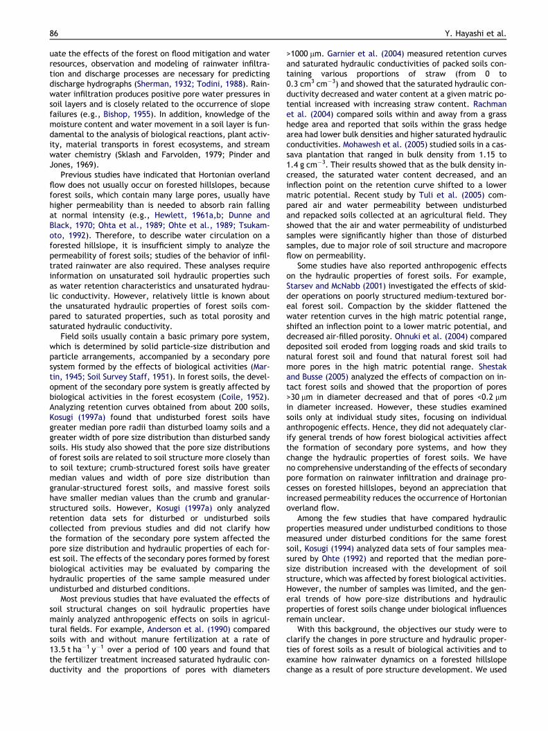
Fig. 3a and b is the histograms of the saturated hydraulicconductivity, Ks, of disturbed and undisturbed samples,respectively. The values of Ks of the disturbed samples forthe soil category Gc (referred to as D-Gc) were significantlyhigher (p < 0.001) than those for D-Gf and D-VA, while D-VAhad significantly lower Ks than D-Gc (p < 0.001) and D-Gf(p < 0.001; Fig. 3a). These differences in Ks among the dis-turbed samples can be attributed to differences in the par-ticle-size-distributions (Fig. 2); D-Gc had the coarsest soiltexture and the largest Ks, while D-VA had the finest textureand the smallest Ks.
In Fig. 3b, the values of Ks of the undisturbed samplesfrom the Gc (referred to as U-Gc) were significantly higher(p < 0.001) than those for U-Gf and U-VA. However, the dif-ferences were smaller than those among the disturbed sam-ples (Fig. 3a). We observed no significant differencebetween U-Gf and U-VA (p = 0.17). In every soil category,the mean Ks of undisturbed samples was greater than thatof disturbed samples.
For each soil sample, were calculated the differences inlog-transformed Ks values between the undisturbed and dis-turbed conditions. These differences represent the incre-ment of soil permeability produced by the formation of a
0 10 20 30
log
Ks
(Ks i
ncm
s-1)
-4
-2
0
Number of samples0 10 20
Gf VAGc *** ***Gf ***
GGc **Gf
(a)
Undisturbed Disturbed samples
Gc
Figure 3 Histograms showing the number of samples with theundisturbed soils, and (c) the number of samples with the speciconditions. Categories Gc, Gf, and VA stand for coarse granite, finfigure indicates the significance level (�) of the difference betwe**p < 0.01; *p < 0.05; –, not-significant.
secondary pore system from biological activities. The histo-gram for the differences (or the increment) is shown inFig. 3c. The increment for Gc was significantly smaller(p < 0.001) than those for Gf and VA. As a result, the differ-ence between Gc and the other two categories (Gf and VA)under the undisturbed condition (Fig. 3b) became smallerthan that under the disturbed condition (Fig. 3a). Althoughthere was no significant difference between mean incre-ments for VA and Gf (p = 0.14), the former (1.49) was largerthan the latter (1.21) as shown in Fig. 3c. That is, the soilscategorized in VA, which had smaller Ks values than the soilscategorized in Gf under the disturbed condition (Fig. 3a),showed larger increments and had similar Ks values to Gf un-der the undisturbed condition (Fig. 3b). As a result, Fig. 3indicates that while the Ks values of disturbed soils showedlarge variations among the categories influenced by the dif-ferences in geological characteristics and particle size dis-tributions, the Ks values of undisturbed soils became moresimilar among the categories after secondary soil poreswere formed under the effects of forest biological activi-ties. This result is supported by the fact that the unbiasedvariance of Ks for all undisturbed samples shown in Fig. 3b(0.58) was smaller than that for the disturbed samplesshown in Fig. 3a (1.07).
Change in soil pore ratio
Fig. 4 shows the histogram of the volumetric pore ratio(pore volume per unit soil volume) for each pore class, fordisturbed (Fig. 4a–d) and undisturbed (Fig. 4e–h) samples.We also computed the difference in the pore ratio betweendisturbed and undisturbed conditions for each soil sample(Fig. 4i–l). The difference represents the increment or de-crease in the pore volume produced by forest biologicalactivities.
In Fig. 4a, the transmission pore ratio of D-VA was signif-icantly lower (p < 0.001) than that of D-Gc and D-Gf, whileD-Gc had a higher transmission pore ratio than D-Gf(p < 0.001). However, for the undisturbed samples, no sig-
(b)
30
(c)
Number of samples0 10 20 30 40
log
Ks
(Ks i
ncm
s-1)
1
2
3
0
f VA* ***
-
Gf VAGc *** ***Gf -
Incrementsamples
VAGf
specified logKs value in each class, for (a) disturbed and (b)fied increment in logKs values from disturbed to undisturbede granite, and volcanic ash soils, respectively. A table in eachen the mean values in the two soil categories. � ***p < 0.001;

Figure 4 Histograms showing the number of samples that had the specified volumetric pore ratio (pore volume per unit soilvolume) in each pore class, for (a–d) disturbed soils and (e–h) undisturbed soils, and (i–l) the number of samples that had thespecified increment in pore ratio from disturbed to undisturbed conditions. Soil pore diameters were classified into transmissionpores (60–600 lm), coarse storage pores (6–60 lm), fine storage pores (0.2–6 lm), and residual pores (less than 0.2 lm) accordingto the equivalent cylindrical diameters. Soil categories and tables in each figure are as described in Fig. 3.
92 Y. Hayashi et al.
nificant difference (p > 0.05) in the transmission pore ratiowas found among U-Gc, U-Gf, and U-VA (Fig. 4e). As shownin Fig. 4i, the increment in the transmission pore ratio fromthe disturbed to undisturbed conditions was significantlylarger for VA and smaller for Gc (p < 0.001). That is,whereas VA had the smallest transmission pore ratio underthe disturbed condition, it showed the largest incrementwhen affected by forest biological activities and had a sim-ilar transmission pore ratio to Gc and Gf under the undis-turbed condition. Although it had the largest transmissionpore ratio for Gc under the disturbed condition, U-Gc exhib-ited a ratio similar to U-Gf and U-VA because of the lower
(or zero) increment produced by forest biological activities.Thus, Fig. 4a, e, and i indicates that after the formation ofsecondary pore systems by forest biological activities, theundisturbed forest soils have similar transmission pore ra-tios regardless of the differences in geological characteris-tics and particle size distributions.
In Fig. 4b, the coarse storage pore ratio of D-VA was sig-nificantly higher (p < 0.001) than that of D-Gf and D-Gc,while D-Gc had a smaller coarse storage pore ratio than D-Gf (p < 0.001). Fig. 4j suggests that for Gf and VA, thecoarse storage pore ratio tended to decrease under the ef-fects of forest biological activities. As a result of these de-

Changes in pore size distribution and hydraulic properties of forest soil resulting from structural development 93
creases, whereas the coarse storage pore ratio was still larg-est for U-VA and smallest for U-Gc (Fig. 4f), the unbiasedvariance for all undisturbed samples shown in Fig. 4f(1.01 · 10�3) became smaller than that for all disturbedsamples shown in Fig. 4b (3.64 · 10�3). Thus, forest biolog-ical activities tended to decrease the differences in thecoarse storage pore ratios among the categories found un-der the disturbed condition.
In Fig. 4c, the fine storage pore ratio of D-VA was signif-icantly higher (p < 0.001) than that of D-Gc. Fig. 4k showsthat forest biological activities decreased the fine storagepore ratio of VA but increased that of Gc. This resulted ina similar fine storage pore ratio between U-VA and U-Gc(Fig. 4g). In Fig. 4c, the fine storage pore ratio of D-Gfwas significantly greater than that of D-Gc (p < 0.001), butwas similar to that of D-VA. Under the undisturbed condi-tion, U-Gf showed a greater fine storage pore ratio thanU-Gc and U-VA on average (Fig. 4g), although this differencewas not very large. The unbiased variance of the fine stor-age pore ratio for whole undisturbed samples (2.26 · 10�4)was smaller than for whole disturbed samples(7.69 · 10�4). As a result, we concluded that forest biologi-cal activities tended to decrease the differences in the finestorage pore ratio among samples.
D-Gf had a significantly higher residual pore ratio(p < 0.001) than D-Gc (Fig. 4d). Under forest biologicalactivities, an increment of residual pore ratio for Gf was sig-nificantly lager than for Gc (p < 0.001) as shown in Fig. 4l.Hence, the difference in the residual pore ratio betweenU-Gf and U-Gc (Fig. 4h) became greater than that betweenD-Gf and D-Gc (Fig. 4d). Under the disturbed condition, theresidual pore ratio of D-Gf was higher than that of D-VA(Fig. 4d). This difference was retained in the undisturbedcondition (Fig. 4h), since there was no significant differencein the amount of increment between Gf and VA (Fig. 4l). Asshown in Fig. 4d, the residual pore ratio did not differbetween D-VA and D-Gc. However, because VA showed ahigher increment than Gc (Fig. 4l), the residual pore ratio
Table 2 Change in pore size distribution from non-structured to
Reference Numberof samples
Texture Transmpore
This studyGc 38 Sand ±Gf 68 Sand +VA 30 Loamy sand +
Ohnuki et al. (2004)a 8 – +Starsev and McNabb (2001)b 128 Loam +Mohawesh et al. (2005)c 6 Clay +Rachman et al. (2004)d 12 Silt loam +Anderson et al. (1990)e 12 Silt loam +Garnier et al. (2004)f 4 Sandy loam �a They compared deposited soil eroded from logging roads and skidb They studied effects of skidder operations on poorly structured mec They studied soil at Cassava plantation area packed with various bd They compared soils within and out of grass hedge area.e They compared soils with and without fertilized treatment of manf They compared packed soils with various straw-pieces content fro
of U-VA was significantly greater than that of U-Gc(p < 0.001; Fig. 4h). Thus, we found a trend that the differ-ence in the residual pore ratio among the categories in-creased as they were affected by forest biologicalactivities. The trend is opposite to the trends found forthe other pore classes and Ks. The unbiased variance forall undisturbed samples (3.24 · 10�3) was greater than thatfor all disturbed samples (2.25 · 10�3).
To summarize Fig. 4, although the pore size distributionsof disturbed soils are greatly influenced by the geologicalcharacteristics and size distributions of soil particles, undis-turbed forest soils had very similar pore size distributions,with the exception of the residual pores. A similar trendwas also found for Ks as is shown in Fig. 3. Consequently,forest biological activities tend to moderate differences inpore structure caused by differences in geological charac-teristics and particle sizes, and form a single general porestructure typical of forest soils.
Change in pore size distribution
Table 2 summarizes the trend of the change in the pore ra-tios from the disturbed to undisturbed conditions shown inFig. 4i–l. Both Gf and VA showed an increment in the trans-mission pores and a decrease in the coarse storage pores.The fine storage pores of Gf showed no clear trend, whilethose of VA tended to decrease. For the soils categorizedin Gc that had the largest gravel content, the transmissionpore ratio and the coarse storage pore ratio exhibited noclear change, but the fine storage pore ratio increased.The residual pore ratio increased in all soil categories.
Fig. 5 is a schematic redrawn from Hillel (1998), whichillustrates the changes in the water retention curve inducedby soil compaction. According to Hillel (1998), the volumeof large interaggregate pores decreases when compactiondestroys the aggregated structure. On the other hand, thevolume of intermediate-size pores is likely to increase in acompacted soil because of the compression of large pores
structured soils
ission Coarse storage pore Fine storagepore
Residual pore
± + +� ± +� � +
� � ++ ± �+ ± �± No date No date� No date No date+ � +
trails, and natural forest soil.dium-textured boreal forest soil.ulk density from 1.15 to 1.4 g cm�3.
ure of 13.5 t ha�1 y�1 for 100 years.m 0 to 0.3 cm3 cm�3.

Figure 5 Schematic cited from Hillel (1998) illustrating thechange in the water retention curve produced by soilcompaction.
94 Y. Hayashi et al.
into intermediate sizes. Because small pores remain unaf-fected, the retention curves of the compacted and uncom-pacted soils tend to converge in the high suction range.
Our results for Gf and VA summarized in Table 2 agreedwith Hillel (1998) in that the undisturbed soils containedmore large pores and fewer intermediate-size pores thanthe disturbed soils. The soils categorized in Gc, which hadmany transmission pores and few coarse storage pores underthe disturbed condition (Fig. 4a and b), exhibited no signif-icant changes from the disturbed to undisturbed condition.A notable difference between Fig. 5 and our results was thatthe undisturbed soils contained more residual pores thanthe disturbed soils for all Gc, Gf, and VA.
Fig. 6 illustrates a comparison between typical retentioncurves observed for the disturbed and undisturbed soils. Therate of change in w for the undisturbed soil was greater inthe range of w > �50 cm and lower in the range ofw < �50 cm than that for the disturbed soil. That is, the
Matric potential (cm)
Vo
lum
etri
cw
ater
con
tent
(c
m3
cm-3
)
0.0
0.1
0.2
0.3
0.4
0.5
0.6Disturbed, measuredUndisturbed, measuredFitted by Eq. (3)
R2= 0.992
R2= 0.987
-10-1-101-102-103-104
-100
Figure 6 Water retention curves for disturbed and undis-turbed samples collected at a depth of 15–20 cm at site R3.
large pores increased and the intermediate-size pores de-creased when affected by forest biological effects, whichagreed well with the trend shown in Fig. 5. However, inFig. 6, the volumetric water content at w = �15,000 cmfor the undisturbed soil was greater than that for the dis-turbed soil by about 0.1 cm3 cm�3, which clearly differedfrom the trend shown in Fig. 5.
Table 2 includes results of some previous studies on thechange in soil pore ratio from non-structured soil to struc-tured soil. The trend in change for each pore size classwas derived from the retention curves published in each lit-erature reference. As soil structure developed, the trans-mission pore ratio tended to increase in all studies withthe exception of Garnier et al. (2004). Garnier et al.(2004) investigated the change in soil retention characteris-tics as soil straw content increased. While manipulating soilsamples to achieve various straw contents, they appliedsome compaction, which may have affected the decreasingtrend in the transmission pore ratio. The coarse storagepore ratio increased in three studies (Starsev and McNabb,2001; Mohawesh et al., 2005; Garnier et al., 2004), whileOhnuki et al. (2004) and Anderson et al. (1990) observed de-creases. We were unable to identify a common trend inchanges in the fine storage pore ratio; the ratio increasedfor Gc and decreased for VA. In previous studies, Ohnukiet al. (2004) and Garnier et al. (2004) observed decreases.As shown in Fig. 5 and 6, the suggestion by Hillel (1998) thatthe retention curves of the compacted and uncompactedsoils tend to converge in the high suction range held truefor neither of the forest soils we studied. The trend awayfrom convergence was also observed in previous studies;Ohnuki et al. (2004) and Garnier et al. (2004) showed thatstructured soils had a higher residual pore ratio than non-structured soils. On the other hand, Starsev and McNabb(2001) and Mohawesh et al. (2005) observed decreases inresidual pore ratio with the development of soil structure.
It should be emphasized that our results were similar tothose of Ohnuki et al. (2004), who compared well-struc-tured and non-structured forest soils. This implies that thetrends in soil structure development produced by forest bio-logical activities are similar for all study sites. The results ofOhnuki et al. (2004) and our results for Gf and VA showedthat coarse storage pores decreased with the developmentof soil structure. For Gc, no increase in the coarse storagepore ratio was observed. Regarding issues of storm-runoffgeneration and water resources management in a forestedwatershed, transmission pores contribute mainly to storm-runoff generation since the rain water held in these poresis weakly constrained by capillary forces and moves rapidlyunder gravity (Mashimo, 1960). On the other hand, water isheld in fine storage pores by relatively large capillaryforces, takes a long time to discharge, and contributes littleto stream water (Mashimo, 1960). Consequently, coarsestorage pores are thought to be most effective for the gen-eration of base flow discharge (Arimitsu, 1987). Thus, theproportion of coarse storage pores has sometimes been usedas an index of the rainwater holding capacity of forest soils(e.g., Takeshita, 1985; Arimitsu, 1987). Lal and Shukla(2004) similarly discussed pore function and suggested thatpores with 0.5 < ECD < 50 lm may retain rainwater tran-siently and release it after the rainfall event. However,the results in Table 2 indicate that soil structure develop-

(a)
0.4
0.5
0.6
0.7(d)
e= 0.4
e= 0.3
e= 0.2
Changes in pore size distribution and hydraulic properties of forest soil resulting from structural development 95
ment as a result of forest biological activities tends to de-crease coarse storage pores. Therefore, when we assumethat the coarse storage pore ratio is an appropriate indexfor the rainwater holding capacity of forest soils, the devel-opment of structure as a result of forest biological activitiesmay have the negative effects of decreasing storm runoffand increasing base flow discharge. In the last part of thisstudy, we provide more detailed soil hydrological analysesof the effects of pore structure development on rainwatermovement.
(e)
0.3
(b)
s(c
m3 cm
-3)
0.3
0.4
0.5
0.6
0.7
(f)
0.1 0.2 0.3
(c)
r (cm3cm-3)
0.1 0.2 0.3
0.3
0.4
0.5
0.6
0.7
D-GcU-Gc
D-GfU-Gf
D-VAU-VA
D-GcU-Gc
D-GfU-Gf
D-VAU-VA
Figure 7 Relationships between hs and hr of disturbed (D) andundisturbed (U) soils for categories Gc, Gf, and VA. (f) showsaverage and SD.
Change in water retention parameters
A non-linear least squares optimization procedure was usedto analyze the observed retention data sets. The parame-ters wm and r in Eq. (3) were optimized using the ‘‘solver’’function of Excel� (Wraith and Or, 1998). Values of hr aredefined as the water content in the range of low matricpotentials for which dh/dw becomes infinitesimally small.In practice, hr can be assumed to be the water content atthe lowest matric potential measured (van Genuchten,1980). We fixed hr at the observed water content at whichw = �15,000 cm. Accurate measurements of hs are difficultespecially for soils that contain macropores, since they losewater quickly when removed for weighing (Kosugi and In-oue, 2002). Therefore, hs was generally treated as one ofthe parameters to be fitted in this study. For some samplesthat showed smooth and continuous changes in water con-tent from saturation to low suction ranges, hs was fixed atthe observed values to improve the specificity of parameteridentification.
In Fig. 6, the water retention curves observed for dis-turbed and undisturbed samples are compared to fittedcurves generated by Eq. (3). It is clear from the figure thatthe LN model performed quite well for each retention dataset. The average R2 coefficient of determination for the en-tire data sets of 136 samples was 0.986, with a minimum R2
value of 0.865. Thus, the LN model can be successfully usedfor producing a functional retention curve for every soilstudied, and the observed retention characteristics can beevaluated from the estimated parameters of the model.
Fig. 7 compares the saturated (hs) and residual (hr) watercontents between disturbed and undisturbed samples(Fig. 7a–c) and among soil categories (Fig. 7d–e). Averagesand SDs for each soil group are summarized in Fig. 7f. It isclear that both hs and hr increased for all categories whensoil structure development was influenced by forest biolog-ical activities (Fig. 7a–c). While the effective soil porosity,he, defined as the difference between hs and hr, increasedfor Gc and VA (Fig. 7a and c), he of Gf showed no significantchange (Fig. 7b). For the disturbed samples, D-Gf had thehighest hs (p < 0.001), and D-Gc had the lowest hs(p < 0.05; Fig. 7d). The average hr was highest for D-Gf(p < 0.001), while there was no significant difference be-tween the hr values of D-Gc and D-VA (p > 0.05; Fig. 7d).Moreover, he at D-Gf was significantly higher than at D-Gcand D-VA (p < 0.01). Of the undisturbed samples, U-Gc hadthe lowest hs (p < 0.01), while hs values for U-Gf and U-VAwere not significantly different (p > 0.05; Fig. 7e). U-Gchad the lowest hr (p < 0.01) and U-Gf had the highest hr(p < 0.001). In contrast to disturbed samples, no significant
difference in he among soil categories was found for theundisturbed samples (p > 0.05). Fig. 7f indicates that VAhad the greatest increment in both hs and hr. While Gfexhibited similar increments in hs and hr values, the incre-ment in hs was greater than that in hr for Gc and VA. As aresult, the average he values of undisturbed samples weresimilar for all soil categories. Thus, despite the differencesin geological characteristics and particle size distributions,he values of the undisturbed soils differed less among thecategories after secondary soil pores were formed underthe effects of forest biological activities.
Fig. 8 shows the relationship between wm and r obtainedfor each sample. In this figure, the median soil pore radius,rm, corresponding to wm (i.e., rm = A/wm) is also shown. InFig. 8a, rm and r for U-Gc were both higher than those forD-Gc.; the median pore size increased and the width ofthe pore size distribution increased as secondary soil poresdeveloped as a result of forest biological activities. A similartrend was found for both Gf and VA (Fig. 8b and c), whereas

D-GcU-Gc
D-GfU-Gf
D-VAU-VA
D-GcU-Gc
D-GfU-Gf
D-VAU-VA
(f)(c)
m (cm)
1.0
1.5
2.0
2.5
3.0
(e)
(a)
1.0
1.5
2.0
2.5
3.0
rm (cm)
0.001 0.01 0.1
(d)
0.001 0.01 0.1
(b)
1.0
1.5
2.0
2.5
3.0
-102 -101 -100 -102 -101 -100
(e)(f)
Figure 8 Relationships between wm and r of disturbed (D)and undisturbed (U) soils for categories Gc, Gf, and VA. (f)shows average and SD.
96 Y. Hayashi et al.
the variation in data was relatively large for Gf. Kosugi(1997a) has shown that forest soils with crumb structurehave large values for median pore radius. Therefore, thelarge rm values for the undisturbed samples indicate theexistence of well-developed crumb structures. In the dis-turbed samples, D-Gc had significantly higher log(rm)(p < 0.001) and D-VA had significantly lower log(rm)(p < 0.001) than other categories (Fig. 8d). While D-Gc andD-Gf had similar r values, D-VA had the lowest r(p < 0.05). These differences in rm and r among the dis-turbed samples can be attributed to the differences in theparticle-size-distributions (Fig. 2); soils with coarser texturehad greater values of rm and r. In the undisturbed samples,U-Gc had the highest log (rm) (p < 0.001) and U-VA had thelowest r (p < 0.01; Fig. 8e). As shown in Fig. 8f, Gc, Gf,and VA all had similar increments in rm and r from disturbedto undisturbed samples.
Following the study of Hara (1984), Or et al. (2000) andLeij et al. (2002) proposed using the advection–dispersionequation, which is a special form of the Fokker–Planckequation, for stochastic modeling of changes in soil poresize distributions associated with tillage operations. In thesimplest case for the application of this equation to thechange in pore size distribution as a result of structuredevelopment, the following simple growth equation for anindividual pore size r may be used:
dr
dt¼ ðv þ snÞr ð7Þ
where v is the relative growth rate (v > 0), n is a random per-turbation approximated by Gaussian white noise, s2 is theintensity coefficient, and t is time (Hara, 1984). AssumingEq. (7), the solution of the advection–dispersion equationbecomes
gðr; tÞ ¼ hs � hr
st1=2rffiffiffiffiffiffi2pp exp � ½ln r � lnðr0evtÞ�2
2s2t
( )ð8Þ
where r0 is the pore radius at t = 0 (Hara, 1984). Eq. (8) indi-cates a lognormal pore radius distribution identical to Eq.(1), as assumed in this study. A comparison between Eqs.(1) and (8) shows that both rm and r increase with time,in agreement with the results shown in Fig. 8f , that bothrm and r increase as the pore structure develops. These re-sults suggest the possibility that the change in the pore-sizedistribution produced by forest biological activities can beexplained by a simple stochastic process as expressed inEq. (7).
Relationship between saturated hydraulicconductivity and retention parameters
Fig. 9 illustrates how each of the retention model parame-ters is related to the observed saturated hydraulic conduc-tivity. In Fig. 9a, Ks is positively correlated with themedian pore radius, rm, which results from the assumptionthat wm satisfies the relation rm = A/wm. Based on a similarmedia concept introduced by Miller and Miller (1956), Ks isexpected to be proportional to the square of rm (Tuliet al., 2001). Kosugi (1997c) derived the same result bycombining Eq. (1) with Mualem’s (1976) conductivity model.We fitted this theoretical relationship to the observed plots(the straight line with a slope of 2 shown in Fig. 9a) andfound that all observed data were well described by a singleline regardless of soil category and soil structure. The coef-ficient of determination, R2, for this line was 0.89 for thedisturbed samples and 0.71 for the undisturbed samples.Fig. 9a indicates that the median pore radius, which is de-rived by assuming a lognormal pore size distribution (i.e.,Eq. (1)), is an important index representing the saturatedhydraulic conductivity for all soil categories and for bothdisturbed and undisturbed soils. Fig. 10 summarizes averageKs and rm values and the SDs for each soil group. The incre-ments in Ks and rm as the secondary soil structure formedwere largest for VA. For every soil category, the incrementvector of Ks and rm was almost parallel to the theoreticalstraight line with a slope of 2.
In Fig. 9b, the correlations between Ks and r are muchless clear, for both the disturbed and undisturbed samples,
10-3 10-2 10-1
D-GcU-Gc
D-GfU-Gf
D-VAU-VA
D-GcU-Gc
D-GfU-Gf
D-VAU-VA
(a)
m (cm)
logK
s(K
s in
cms-1
)
-4
-3
-2
-1
0(b)
1.0 1.5 2.0 2.5 3.0
(c)
e (cm3cm-3)
0.2 0.3 0.4 0.5 0.6-103 -102 -101 -100
rm (cm)
Figure 9 Relationship between observed Ks and retention model parameters (a) wm, (b) r, and (c) he. (a) includes a fitted line witha theoretical slope value of 2.
(d)
ψm (cm)
rm (cm)
0.001 0.01 0.1
-102 -101 -100
logK
s(K
sin
cm
s-1
)
-4
-3
-2
-1
0
D-GcU-Gc
D-GfU-Gf
D-VAU-VA
D-GcU-Gc
D-GfU-Gf
D-VAU-VA
Figure 10 Average and SD of logwm and logKs with the fittedline shown in Fig. 9a.
Changes in pore size distribution and hydraulic properties of forest soil resulting from structural development 97
than the correlations between Ks and rm. For the disturbedsamples, a slight positive correlation (R2 = 0.37) was foundfor D-Gc, while D-Gf showed a slight negative correlation(R2 = 0.23). In Fig. 9c, Ks is compared with the effective soilporosity, he (=hs � hr). The whole undisturbed sample datashowed a weak positive correlation (R2 = 0.23). For individ-ual soil categories, a relatively high correlation was foundfor U-Gf (R2 = 0.57) and U-VA (R2 = 0.68). For the disturbedsoils, there was no clear correlation between Ks and he inevery soil category. Thus, Fig. 9 indicates that the widthof the soil pore distribution (r) and the soil porosity effec-tive for water storage (he) is less significant for determiningthe saturated hydraulic conductivity than the median soilpore radius (rm).
Mean hydraulic properties
Table 3 summarizes mean parameter values of the LN modelfor each soil category. By substituting these mean valuesinto Eqs. (3), (4), and (6), typical hydraulic property func-tions were plotted for disturbed and undisturbed soils ineach category in Fig. 11.
For every soil category, the difference between the dis-turbed and undisturbed retention curves exhibited a trendsimilar to that shown in Fig. 6 (Fig. 11a–c). That is, theundisturbed soil had a higher hs than the disturbed samples.In the wet soil region, the rate of change in h for the undis-turbed soil was higher than that for the disturbed soil be-cause of the presence of more large pores, as indicated bythe larger median pore radius and the greater width ofthe pore radius distribution (Table 3). Because of the higherrate of change in h, the undisturbed soil had a lower h valuethan the disturbed soil in the mid w range. In the dry soil re-gion, the undisturbed soil again had a higher h value thanthe disturbed soil. The value of hr was greater for the undis-turbed soil than for the disturbed soil (Table 3). Among thethree categories, the difference between the disturbed andundisturbed retention curves was most pronounced in VA,which was characterized by the finest particle size distribu-tion (Fig. 2).
In Fig. 11d–f, the typical undisturbed soil had a higher Ksthan the disturbed soil for every soil category. The Ks valuesfor D-Gf and D-VA were 33.8 and 9.46 mm h�1, respectively(Table 3). For these disturbed soils, Hortonian overlandflow may occur with heavy storms. The Ks values for D-Gcand all undisturbed soils were much larger than the maxi-mal rainfall intensity usually expected in the studied re-gions. Therefore, the occurrence of Hortonian overlandflow is not expected for these soils. On the K–w curvesshown in Fig. 11d–f, the rate of change in K for the undis-turbed soil was higher than that for the disturbed soil in thewet region because the undisturbed soil contained morelarge pores than the disturbed soil (Fig. 11a–c and Table3). Because of this rapid change, the undisturbed soil had

Table 3 Mean values for parameters of the water retention function expressed as Eq. (3) (LN model) and observed saturatedhydraulic conductivity
Typeof samples
Categories Numberof datesets
hs hr wma (rm
a) r Ksa
cm3 cm�3 cm3 cm�3 cm (lm) cm s�1 (mm h�1)
Disturbedsamples
Gc 19 0.339 0.068 �24.1 (61.40) 1.69 4.15E � 02 (1.49E + 03)Gf 34 0.486 0.144 �90.0 (16.41) 1.54 9.40E � 04 (3.38E + 01)VA 15 0.370 0.064 �179.2 (8.25) 1.18 2.63E � 04 (9.46E + 00)
Undisturbedsamples
Gc 19 0.419 0.085 �9.1 (162.17) 2.19 1.51E � 01 (5.45E + 03)Gf 34 0.519 0.187 �36.2 (40.81) 2.00 1.52E � 02 (5.49E + 02)VA 15 0.477 0.124 �39.0 (37.86) 1.57 8.07E � 03 (2.91E + 02)
a Geometric mean.
10-10
10-7
10-4
10-1
102
105
108
D-GcU-Gc
D(c
m2
s-1)
10-10
10-7
10-4
10-1
102
105
108
D-GfU-Gf
(cm)
10-10
10-7
10-4
10-1
102
105
108
D-VAU-VA
(cm)
0.0
0.1
0.2
0.3
0.4
0.5
D-VAU-VA
-101-102-103 -100-104 -10-1 -10-2
-20
-15
-10
-5
D-GfU-Gf
logK
(Kin
cms-1
)
-20
-15
-10
-5
D-GcU-Gc
(cm)
-20
-15
-10
-5
D-VAU-VA
-101-102-103 -100-104 -10-1 -10-2-101-102-103 -100-104 -10-1 -10-2
(cm
3cm
-3)
0.0
0.1
0.2
0.3
0.4
0.5
D-GfU-Gf
0.0
0.1
0.2
0.3
0.4
0.5
D-GcU-Gc
(a) (d) (g)
(b) (e) (h)
(c) (f) (i)
Figure 11 Typical (a–c) retention, (d–f) hydraulic conductivity, and (g–i) water diffusivity functions for disturbed (D) andundisturbed (U) soils in categories Gc, Gf, and VA.
98 Y. Hayashi et al.
a lower K value than the disturbed soil in the dry region. Inthe driest region, K for the undisturbed soil again becamehigher than that for the disturbed soil for the category Gcand Gf.
Fig. 11g–i shows the plots of the soil water diffusivity, D,which is defined as
D ¼ K=C ð9Þ
The D–w relationships were generated from Eqs. (4) and (6)using the mean parameter values. The value of D is closely
related to the rainwater infiltration process; Tani (1982) re-ported that a smaller D results in a slower water-table risein a soil column when rainfall is supplied at a constant rate.Furthermore, Kosugi (1997b) conducted numerical simula-tions for rainwater infiltration under natural rainfall condi-tions and established that the hydrograph from the soilcolumn becomes smoother when the soil has a lower D va-lue. Thus, D can effectively be used as an index for charac-terizing the vertical rainwater infiltration process; a soilcharacterized by a lower D value exhibits a greater capacity
Changes in pore size distribution and hydraulic properties of forest soil resulting from structural development 99
to hold rainwater (Swartzendruber, 1969; Seguchi et al.,1982). The role of D in affecting hillslope hydrology hasbeen previously discussed (e.g., Haneberg, 1991; Reid,1994; Iverson, 2000).
In Fig. 11g–i, D was lower for the undisturbed soil thanfor the disturbed soil in every soil category except the mostdry region of Gf (w < �5 · 103 cm). This implies that in everycategory, the undisturbed soil had greater rainwater holdingcapacity than the disturbed soil. However, Table 2 showedthat the coarse storage pore ratio, which has frequentlybeen used as an index of the water holding capacity derivedfrom the pore classification system based on pore function(Mashimo, 1960), tended to be smaller for undisturbed for-est soils than for disturbed forest soils (Fig. 4 and Table 2).In the following section, we will use a numerical simulationto analyze how the soil structure development affected byforest biological activities can change the water holdingcapacity of forest soils.
Simulation of rainwater infiltration and drainage
We conducted numerical simulations of rainwater infiltra-tion and vertical drainage processes in a soil profile, assum-ing the mean hydraulic properties for disturbed andundisturbed forest soils summarized in Fig. 11 and Table3. For each soil category, we assumed two scenarios; in Sce-nario A, the whole of a 90-cm soil layer is characterized bythe hydraulic properties for the disturbed or undisturbedsoil; in Scenario B, the same soil layer as that of ScenarioA overlies a soil layer 90-cm thick with the disturbed soilhydraulic properties. That is, the total soil thickness is180 cm in Scenario B.
The Richards equation for vertical unsaturated waterflow,
CðwÞ owot¼ o
ozKðwÞ ow
oz
� �þ o
ozKðwÞ ð10Þ
where t and z represent time and vertical distance (whereupward is positive), respectively, was solved using a fully-implicit finite difference scheme. The time and space incre-ments used were 1 min and 1 cm, respectively, and themodified Picard’s method (Celia et al., 1990) was adoptedto ensure strict mass conservation. To obtain C and K valuesin Eq. (10), the average parameters summarized in Table 3were substituted into Eqs. (4) and (6), respectively. The ini-tial condition was hydraulic equilibrium under a zero-fluxcondition, i.e.,
w ¼ �z ð0 6 z 6 LÞ ð11Þ
where L is the thickness of the soil layer and z = 0 corre-sponds to the bottom of the soil layer. A constant water ta-ble condition (i.e., w = 0) was imposed at z = 0, and thewater drainage rate, qout, was computed. A hyetographfor 20 days was generated based on observations at Mt. Rok-kou (solid triangle in Fig. 1) and used as input water flux atthe soil surface. Total rainfall was 112 mm and the maximal1-h rainfall was 9 mm (Fig. 12a). Because the maximal 1-hrainfall was smaller than Ks values for any soils (Table 3),neither positive pressure on the soil surface nor surface run-off was computed for any soils and any scenarios. Thus, inthe numerical simulations, the total amount of infiltrated
water was the same for all runs, and we examined the ef-fects of soil hydraulic properties on the propagation of theinfiltrated water in the soil profile. The 20-day hydrographrun was repeated twice followed by a 20-day no-rainfall per-iod, resulting in a total simulation period of 60 days(Fig. 12a). No soil surface evaporation or root water uptakewere considered.
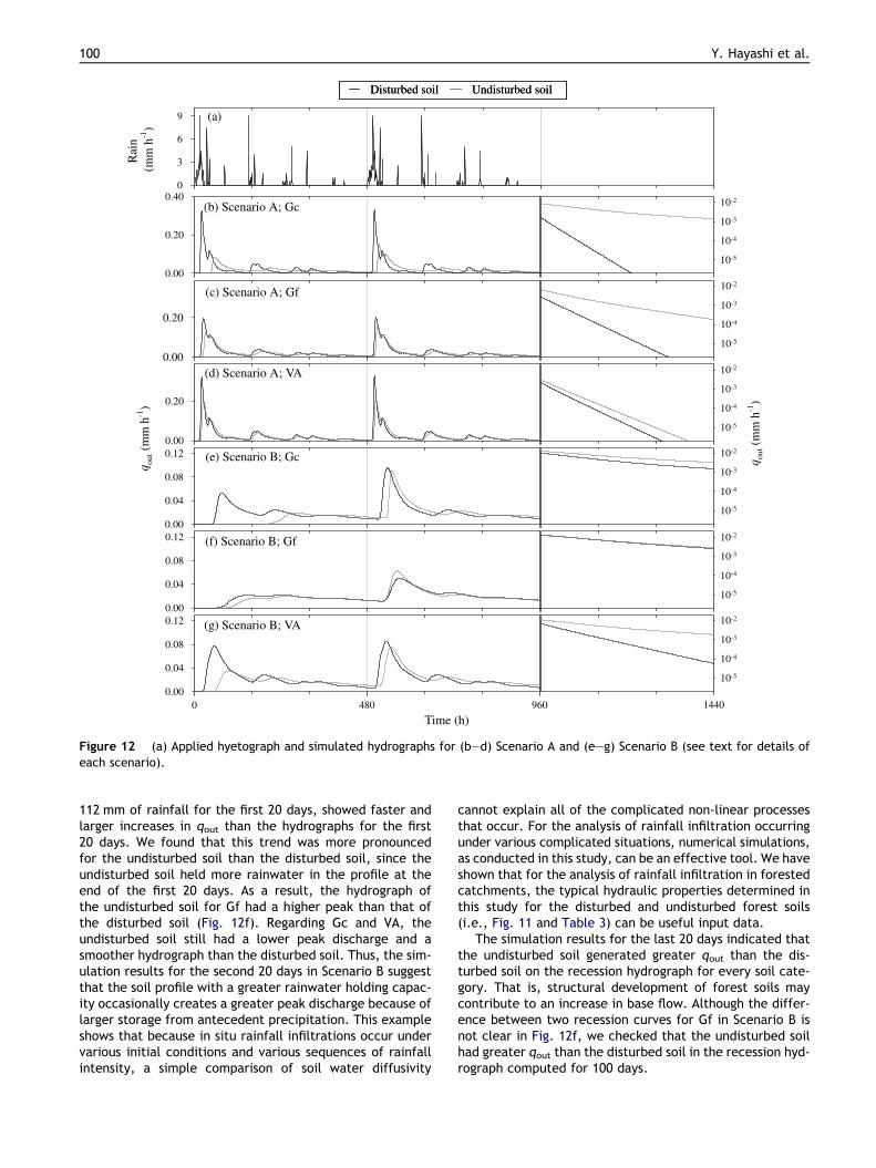
The computed hydrograph for each scenario and foreach soil category is shown in Fig. 12b–g. The hydrographfor the first 20 days was derived with the initial conditionexpressed by Eq. (11), one of the ideal hydraulic conditionsrepresenting the completely drained condition, althoughthis is not necessarily a natural condition observed in thefield. For the following 20 days, the initial soil moisturecondition was more realistic after experiencing the first20-day hyetograph. We checked that when the 20-day hye-tograph run was repeated three times, a computed hydro-graph for the third repetition was similar to that for thesecond repetition (data not shown). For the last 20 daysin Fig. 12, recession hydrographs were compared using asemi-logarithmic scale.
Fig. 12b–d shows the hydrographs computed whenL = 90 cm (Scenario A). For every soil category, the peak dis-charge for the undisturbed soil occurred later and becamesmaller than that for the disturbed soil. The hydrographsfor the second 20 days were similar to those for the first20-day period, indicating that the initial moisture condition,assumed as Eq. (11), imposed no significant effects on thetrends of hydrographs in Scenario A. On the recession hydro-graphs for the last 20 days, the undisturbed soil producedgreater qout than the disturbed soil in every category. Com-paring these results with the soil water diffusivity, D, shownin Fig. 11g–i, it is clear that soils with smaller D values gen-erated smoother hydrographs. These results agree with Ko-sugi (1997b), who found that D is an appropriate indexcharacterizing vertical infiltration-drainage processes. Weconclude that as secondary pore systems are formed as a re-sult of forest biological activities, the value of D decreases(Fig. 11g–i) and an increased amount of rainwater is storedin the soil profile during storm events. Thus, the soil struc-ture development of forest soils may have the effect ofdecreasing storm runoff and increasing base flow dischargefrom a forested watershed. On the other hand, the coarsestorage pore ratio is not necessarily an appropriate indexfor the rainwater holding capacity of forest soils, sincethe ratio tended to decrease (for Gf and VA) or not tochange (for Gc) with the development of forest soilstructure.
The computed hydrographs for L = 180 cm (Scenario B)are shown in Fig. 12e–g. For every run, the hydrographhad a lower peak and a more gradual recession than thatcomputed when L = 90 cm, supporting the fact that a thick-er soil has greater water-holding capacity (e.g., Kosugi,1997b). On the hydrographs for the first 20 days, the undis-turbed soil generated a delayed increase in qout comparedto the disturbed soil. The peak discharge for the undis-turbed soil occurred later and became smaller than thatfor the disturbed soil. That is, soil structure developmentincreases rainwater holding capacity under the initial condi-tion expressed as Eq. (11).
The hydrographs for the second 20 days, which werecomputed with wetter initial conditions after applying
Disturbed soil Undisturbed soilDisturbed soil Undisturbed soil
1440
10-5
10-4
10-3
10-2
(f) Scenario B; Gf
0.00
0.04
0.08
0.12
(e) Scenario B; Gc
q out (
mm
h-1
)
0.00
0.04
0.08
0.12
(g) Scenario B; VA
Time (h)0 480 960
0.00
0.04
0.08
0.12
(c) Scenario A; Gf
0.00
0.20
(b) Scenario A; Gc
0.00
0.20
0.40
(d) Scenario A; VA
0.00
0.20
(a)R
ain
(mm
h-1
)
0
3
6
9
10-5
10-4
10-3
10-2
10-5
10-4
10-3
10-2
q out (
mm
h-1
)
10-5
10-4
10-3
10-2
10-5
10-4
10-3
10-2
10-5
10-4
10-3
10-2
Figure 12 (a) Applied hyetograph and simulated hydrographs for (b–d) Scenario A and (e–g) Scenario B (see text for details ofeach scenario).
100 Y. Hayashi et al.
112 mm of rainfall for the first 20 days, showed faster andlarger increases in qout than the hydrographs for the first20 days. We found that this trend was more pronouncedfor the undisturbed soil than the disturbed soil, since theundisturbed soil held more rainwater in the profile at theend of the first 20 days. As a result, the hydrograph ofthe undisturbed soil for Gf had a higher peak than that ofthe disturbed soil (Fig. 12f). Regarding Gc and VA, theundisturbed soil still had a lower peak discharge and asmoother hydrograph than the disturbed soil. Thus, the sim-ulation results for the second 20 days in Scenario B suggestthat the soil profile with a greater rainwater holding capac-ity occasionally creates a greater peak discharge because oflarger storage from antecedent precipitation. This exampleshows that because in situ rainfall infiltrations occur undervarious initial conditions and various sequences of rainfallintensity, a simple comparison of soil water diffusivity
cannot explain all of the complicated non-linear processesthat occur. For the analysis of rainfall infiltration occurringunder various complicated situations, numerical simulations,as conducted in this study, can be an effective tool. We haveshown that for the analysis of rainfall infiltration in forestedcatchments, the typical hydraulic properties determined inthis study for the disturbed and undisturbed forest soils(i.e., Fig. 11 and Table 3) can be useful input data.
The simulation results for the last 20 days indicated thatthe undisturbed soil generated greater qout than the dis-turbed soil on the recession hydrograph for every soil cate-gory. That is, structural development of forest soils maycontribute to an increase in base flow. Although the differ-ence between two recession curves for Gf in Scenario B isnot clear in Fig. 12f, we checked that the undisturbed soilhad greater qout than the disturbed soil in the recession hyd-rograph computed for 100 days.

Changes in pore size distribution and hydraulic properties of forest soil resulting from structural development 101
Summary
A study was conducted to characterize and compare thepore structure and hydraulic properties of forest soils underdisturbed and undisturbed conditions for the purpose ofexamining how rainwater dynamics on a forested hillslopechange as a result of pore structure development influencedby forest biological activities. The results are summarizedas follows:
1. While pore size distributions and saturated hydraulicconductivities of disturbed soils were greatly influencedby the geological characteristics and particle size distri-butions, undisturbed forest soils had relatively similarpore size distributions and saturated hydraulic conduc-tivities, with the exception of the proportion of residualpores remaining after secondary soil pores were formedas a result of forest biological activities.
2. The undisturbed forest soils contained more large poresand fewer intermediate-size pores than the disturbedsoils, agreeing with the results of Hillel (1998), who dem-onstrated the change in the water retention curve pro-duced by soil compaction. On the other hand, whileHillel (1998) suggested that retention curves of com-pacted and uncompacted soils tend to converge in thelow matric potential range, our results indicated thatundisturbed forest soils have greater residual water con-tent than disturbed soils.
3. The median pore radius and the width of the pore sizedistribution increased as secondary soil pores developed.This suggests the possibility that the change in the pore-size distribution as a result of forest biological activitiescan be approximated by a simple stochastic process.
4. The median pore radius, which was derived by assuminga lognormal pore size distribution, was an importantindex representing the saturated hydraulic conductivityfor both disturbed and undisturbed soils.
5. As secondary pore systems were formed from the effectsof forest biological activities, the water diffusivity of for-est soil tended to decrease. Numerical simulations ofrainwater infiltration and vertical drainage processes ina soil profile, which were conducted by assuming themean hydraulic properties for disturbed and undisturbedforest soils, revealed that the soil structure developmentof forest soils had the effect of decreasing storm runoffand increasing base flow discharge.
References
Anderson, S.H., Gantzer, C.J., Brown, J.R., 1990. Soil physicalproperties after 100 years of continuous cultivation. J. SoilWater Conserv. 45, 117–121.
Arimitsu, K., 1970. Analysis of soil pore radius distribution using asuction plate (in Japanese*). Jpn. J. For. Environ. 12 (1), 31–35.
Arimitsu, K., 1987. Water Holding Mechanism of Forest Soils (inJapanese*), Sobun, Tokyo, Japan.
Bishop, A.W., 1955. The use of the slip circle in the stability analysisof slopes. Geotechnique 5, 7–17.
Brooks, R.H., Corey, A.T., 1964. Hydraulic properties of porousmedia, Hydrol. Pap. 3, Civil Eng. Dept., Colo. State Univ., FortCollins.
Burdine, N.T., 1953. Relative permeability calculation from sizedistribution data. Trans. Am. Inst. Min. Metall. Pet. Eng. 198,71–78.
Brutsaert, W., 1966. Probability laws for pore-size distributions.Soil Sci. 101, 85–92.
Celia, M.A., Bouloutas, E.T., Zerba, R.L., 1990. A general mass-conservative numerical solution for the unsaturated flow equa-tion. Water Resour. Res. 26 (7), 1483–1496.
Coile, T.S., 1952. Soil and growth of forests. Advance in Agronomy4, New York.
Dunne, T., Black, R.D., 1970. An experimental investigation ofrunoff production in permeable soils. Water Resour. Res. 6,1296–1311.
Garnier, P., Ezzine, N., De Gryze, S., Richard, G., 2004. Hydraulicproperties of soil–straw mixtures. Vadose Zone J. 3, 714–721.
Greenland, D.J., 1977. Soil damage by intensive arable cultivation:temporary or permanent? Phil. Trans. Roy. Soc. Lond. B 281,193–208.
Grossman, R.B., Reinsch, T.G., 2002. Core method. In: Klute, A.(Ed.), Methods of Soil Analysis. Part 4 – Physical Methods,Monograph, vol. 9. ASA and SSSA, Madison, WI, pp. 207–209.
Haneberg, W.C., 1991. Observation and analysis of pore pressurefluctuations in a thin colluvium landslide complex near Cincin-nati, Ohio. Eng. Geol. 31, 159–184.
Hara, T., 1984. A stochastic model and the moment dynamics of thegrowth and size distribution in plant populations. J. Theor. Biol.109, 173–190.
Hewlett, J.D., 1961a. Watershed management, US Dept. Agric.,Forest Service, Southeastern Forest Experiment Station, Ash-ville, NC, Report for 1961, pp. 61–66.
Hewlett, J.D., 1961b. Soil moisture as a source of base flow fromsteep mountain watersheds, US Dept. Agric., Forest Service,Southeastern Forest Experiment Station, Ashville, NC, StationPaper No. 132, p. 11.
Hillel, D., 1998. Environmental Soil Physics. Academic Press, NewYork, 156pp..
Iverson, R.M., 2000. Landslide triggering by rain infiltration. WaterResour. Res. 36, 1897–1910.
Jury, W.A., Gardner, W.R., Gardner, W.H., 1991. Soil Physics.Wiley, New York.
Kawada, H., 1989. Introduction to Forest Soil Science (in Japa-nese*), Hakuyu-sha, Tokyo, Japan.
Kawada, H., Kojima, T., 1976. Means of Environmental Research,IV, Forest Soils (in Japanese*), Kyoritsu, Tokyo, Japan.
Kay, B.D., 1990. Rates of change in soil structure under difficultcropping systems. Adv. Soil. Sci. 12, 1–52.
Klute, A., Dirksen, C., 1986. Hydraulic conductivity and diffusivity:laboratory methods. In: Klute, A. (Ed.), Methods of Soil Analysis,Part 1: Physical and Mineralogical Methods, Monograph, vol. 9.Am. Soc. Agron., Madison, WI.
Kobayashi, S., 1982. Changes in soil caused by forest clear-cutting(in Japanese). Pedologist 26, 150–163.
Kobashi, S., Murai, H., Kameyama, A., 1992. Environmental Reveg-etation Technology (in Japanese). Asakura, Tokyo, Japan.
Kosugi, K., 1994. Analysis of water retention curves of forest soilswith three-parameter longnormal distribution model. J. Jpn.For. Soc. 76 (5), 433–444.
Kosugi, K., 1996. Lognormal distribution model for unsaturated soilhydraulic properties. Water Resour. Res. 32, 2697–2703.
Kosugi, K., 1997a. A new model to analyze water retentioncharacteristics of forest soils based on soil pore radius distribu-tion. J. Forest Res. 2, 1–8.
Kosugi, K., 1997b. Effect of pore radius distribution of forest soilson vertical water movement in soil profile. J. Jpn. Soc. Hydrol.Water Resour. 10, 226–237.
Kosugi, K., 1997c. New diagrams to evaluate soil pore radiusdistribution and saturated hydraulic conductivity of forest soil.J. Forest Res. 2, 95–101.

102 Y. Hayashi et al.
Kosugi, K., Inoue, M., 2002. Estimation of hydraulic properties ofvertically heterogeneous forest soil from transient matricpressure date. Water Resour. Res. 38 (12), 1322.
Kumlung, A., Takeda, Y., 1991. Changes of soil properties inrelation to lapsed years of hillside works on a granite area. J.Jpn. For. Soc. 73, 327–338.
Kutı́lek, M., Nielsen, D.R., 1994. Soil Hydrology. Catena Verlag,Cremlingen, Germany.
Lal, R., Shukla, M.K., 2004. Principles of Soil Physics. The Ohio StateUniversity Columbus, Ohio, USA.
Lebron, I., Robinson, D.A., 2003. Particle size segregation duringhand packing of coarse granular materials and impacts on localpore-scale structure. Vadose Zone J. 2, 330–337.
Leij, F.J., Ghezzehei, T.A., Or, D., 2002. Analytical model for soilpore size distribution after tillage. Soil Sci. Soc. Am. J. 66,1104–1114.
Luxmoore, R.J., 1981. Macro-, meso-, and macroporosity of soil.Soil Sci. Soc. Am. J. 45, 671–672.
Martin, J.P., 1945. Microorganism and soil aggregation. 1. Originand nature of some of the aggregating substances. Soil Sci. 59,163–174.
Mashimo, Y., 1960. Studies on the physical properties of forest soiland their relation to the growth of sugi (Cryptomeria japonica)and hinoki (Chamaecyparis obtusa) (in Japanese with EnglishSummary). Forest Soils Jpn. 11, 1–182.
Miller, E.E., Miller, R.D., 1956. Physical variability of field-measured soil-water properties. Hilgardia 42, 215–259.
Mohawesh, O., Fukumura, K., Ishida, T., Yoshino, K., 2005. Soilhydraulic properties in a Cassava field as a function of soil drybulk density. J. Jpn. Soc. Hydrol. Water Resour. 18 (2).
Mualem, Y., 1976. Catalogue of the hydraulic properties ofunsaturated soils, Proj. 442, Technion-Israel Inst. of Technol.,Haifa, Israel, 100pp.
Ogasiwa, K., Kondou, T., Mashimo, Y., 1991. An analysis of factorsaffecting coarse pore volume of forest soil with the quantifica-tion-I method, I, coarse pore volume of soil at various depth insugi (Cryptomeria japonica) stands (in Japanese). J. Jpn. For.Soc. 73, 393–395.
Ohnuki, Y., Terazono, R., Ikuzawa, H., Hirata, I., 1994. Distributionand physical properties of surficial soils in Minami-Meijiyamaexperimental watershed in Okinawa Island, Japan (in Japanese).J. Jpn. For. Soc. 76, 355–360.
Ohnuki, Y., Noguchi, S., Sasaki, S., Abdoul Rahim, N., AbdoulSalam, A.C., 2004. Effects of buffer zone against soil runoffafter selective logging in Bukit Terek experimental watershed,Malaysia. In: Forests and Water in Warm, Humid Asia. Proceed-ing of a Workshop of IUFRO Forest Hydrology Working Group, pp.215–218.
Ohta, T., Katagiri, M., Kohno, Y., 1989. Measurement of thesaturated hydraulic conductivity of forest soil with a large-scalesampler (II) (in Japanese). J. Jpn. For. Soc. 71 (4), 164–167.
Ohte, N., Suzuki, M., Kubota, J., 1989. Hydraulic properties offorest soils (I): The vertical distribution of saturated-unsatu-rated hydraulic conductivity (in Japanese). J. Jpn. For. Soc. 71(4), 137–147.
Ohte, N., 1992. Studies on Pore Structure and Hydraulic Propertiesof Forest Soils (in Japanese), A doctor thesis, Kyoto University.
Or, D., Leij, F.J., Snyder, V., Ghezzehei, T.A., 2000. Stochasticmodel for posttillage soil pore space evolution. Water Resour.Res. 36 (7), 1641–1652.
Pinder, G.F., Jones, J.F., 1969. Determination of the ground-watercomponent of peak discharge from the chemistry of total runoff.Water Resour. Res. 5, 438–445.
Rachman, A., Anderson, S.H., Gantzer, C.J., Alberts, E.E., 2004.Soil hydraulic properties influence by stiff-stemmed grass hedgesystems. Soil Sci. Soc. Am. J. 68, 1368–1393.
Reid, M.E.A., 1994. Pore-pressure diffusion model for estimatinglandslide inducing rainfall. J. Geol. 102, 709–717.
Seguchi, M., Tanaka, K., Shikasho, S., 1982. Baseflow recessioncurve of small mountain river and its physical significances (inJapanese with English summary). Trans. JSIDRE 97, 1–8.
Sherman, L.K., 1932. Streamflow from rainfall by the unit graphmethod. Eng. News Rec. 108, 501–505.
Shestak, C.J., Busse, M.D., 2005. Compaction alters physical butnot biological indices of soil health. Soil Sci. Soc. Am. J. 69,236–246.
Sklash, M.G., Farvolden, R.N., 1979. The role of groundwater instorm runoff. J. Hydrol. 43, 45–65.
Soil Survey Division Staff, 1951. Soil Survey Manual, Hand-book No.18. U.S. Department of Agriculture, U.S. Govt. Printing Office,Washington, DC.
Starsev, A.D., McNabb, D.H., 2001. Skidder traffic effects on waterretention, pore-size distribution, and van Genuchten parametersof boreal forest soils. Soil Sci. Soc. Am. J. 65, 224–231.
Swartzendruber, D., 1969. The flow of water in unsaturated soils.In: De Wiest, R.J.M. (Ed.), Flow through Porous Media. AcademicPress, New York, pp. 215–292.
Takeshita, K., 1985. Some considerations on the relation betweenforest soil and control function to river discharge (in Japanese).Jpn. J. For. Environ. 27 (2), 19–26.
Tani, M., 1982. The properties of a water-table rise produced by aone-dimensional, vertical, unsaturated flow (in Japanese withEnglish summary). J. Jpn. For. Soc. 64, 409–418.
Todini, E., 1988. Rainfall-runoff modeling-past, present and future.J. Hydrol. 100, 341–352.
Tsukamoto, Y., 1992. Forest Hydrology (in Japanese*), Buneido,Tokyo, Japan.
Tuli, A., Hopmans, J.W., Rolston, D.E., Moldrup, P., 2005.Comparison of air and water permeability between disturbedand undisturbed soils. Soil Sci. Soc. Am. J. 69, 1361–1371.
Tuli, A., Kosugi, K., Hopmans, J.W., 2001. Simultaneous scaling ofsoil water retention and unsaturated hydraulic conductivityfunction assuming lognormal pore-size distribution. Adv. WaterResour. 24, 677–688.
van Genuchten, M.Th.A., 1980. Closed-form equation for predictingthe hydraulic conductivity of unsaturated soils. Soil Sci. Soc.Am. J. 44 (5), 892–898.
Wraith, J.M., Or, D., 1998. Non-linear parameter estimation usingspread sheet softwater. J. Nat. Resour. Life Sci. Educ. 27, 13–19.