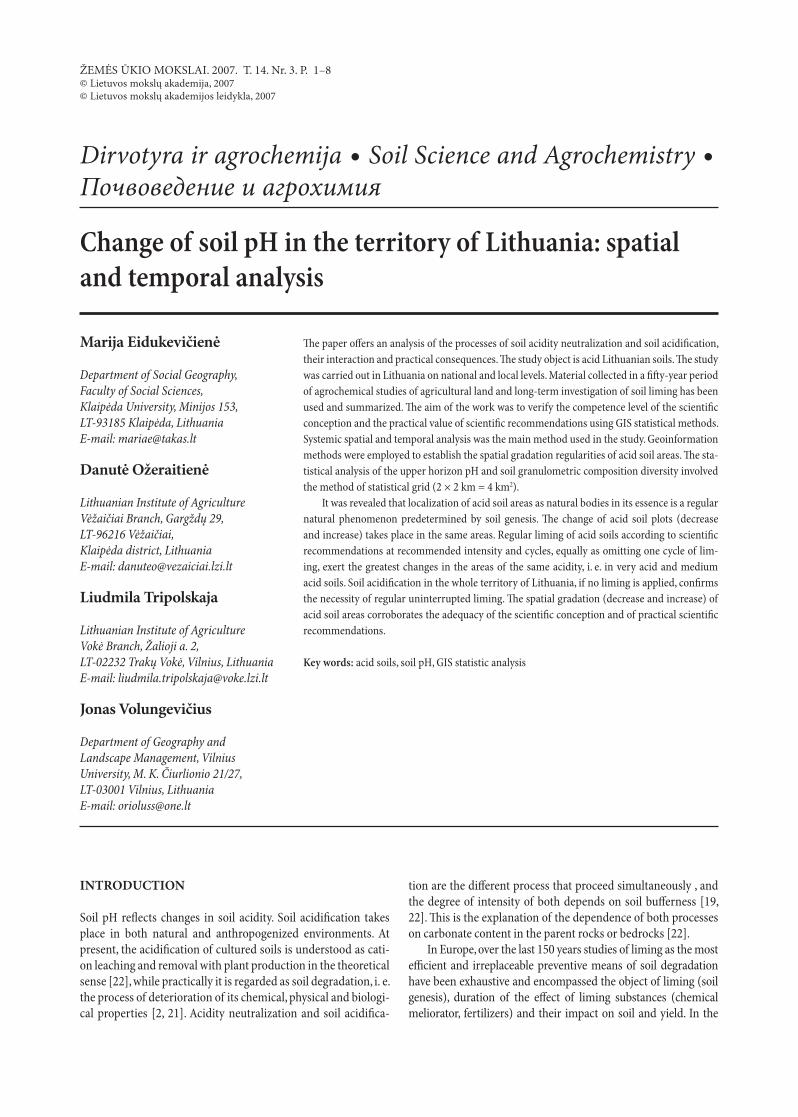
Change of soil pH in the territory of Lithuania: spatial...
8
Dirvotyra ir agrochemija Soil Science and Agrochemistry Почвоведение и агрохимия ŽEMĖS ŪKIO MOKSLAI. 2007. T. 14. Nr. 3. P. 1–8 © Lietuvos mokslų akademija, 2007 © Lietuvos mokslų akademijos leidykla, 2007 Change of soil pH in the territory of Lithuania: spatial and temporal analysis e paper offers an analysis of the processes of soil acidity neutralization and soil acidification, their interaction and practical consequences. e study object is acid Lithuanian soils. e study was carried out in Lithuania on national and local levels. Material collected in a fiſty-year period of agrochemical studies of agricultural land and long-term investigation of soil liming has been used and summarized. e aim of the work was to verify the competence level of the scientific conception and the practical value of scientific recommendations using GIS statistical methods. Systemic spatial and temporal analysis was the main method used in the study. Geoinformation methods were employed to establish the spatial gradation regularities of acid soil areas. e sta- tistical analysis of the upper horizon pH and soil granulometric composition diversity involved the method of statistical grid (2 × 2 km = 4 km 2 ). It was revealed that localization of acid soil areas as natural bodies in its essence is a regular natural phenomenon predetermined by soil genesis. e change of acid soil plots (decrease and increase) takes place in the same areas. Regular liming of acid soils according to scientific recommendations at recommended intensity and cycles, equally as omitting one cycle of lim- ing, exert the greatest changes in the areas of the same acidity, i. e. in very acid and medium acid soils. Soil acidification in the whole territory of Lithuania, if no liming is applied, confirms the necessity of regular uninterrupted liming. e spatial gradation (decrease and increase) of acid soil areas corroborates the adequacy of the scientific conception and of practical scientific recommendations. Key words: acid soils, soil pH, GIS statistic analysis Marija Eidukevičienė Department of Social Geography, Faculty of Social Sciences, Klaipėda University, Minijos 153, LT-93185 Klaipėda, Lithuania E-mail: [email protected] Danutė Ožeraitienė Lithuanian Institute of Agriculture Vėžaičiai Branch, Gargždų 29, LT-96216 Vėžaičiai, Klaipėda district, Lithuania E-mail: [email protected] Liudmila Tripolskaja Lithuanian Institute of Agriculture Vokė Branch, Žalioji a. 2, LT-02232 Trakų Vokė, Vilnius, Lithuania E-mail: [email protected] Jonas Volungevičius Department of Geography and Landscape Management, Vilnius University, M. K. Čiurlionio 21/27, LT-03001 Vilnius, Lithuania E-mail: [email protected] INTRODUCTION Soil pH reflects changes in soil acidity. Soil acidification takes place in both natural and anthropogenized environments. At present, the acidification of cultured soils is understood as cati- on leaching and removal with plant production in the theoretical sense [22], while practically it is regarded as soil degradation, i. e. the process of deterioration of its chemical, physical and biologi- cal properties [2, 21]. Acidity neutralization and soil acidifica- tion are the different process that proceed simultaneously , and the degree of intensity of both depends on soil bufferness [19, 22]. is is the explanation of the dependence of both processes on carbonate content in the parent rocks or bedrocks [22]. In Europe, over the last 150 years studies of liming as the most efficient and irreplaceable preventive means of soil degradation have been exhaustive and encompassed the object of liming (soil genesis), duration of the effect of liming substances (chemical meliorator, fertilizers) and their impact on soil and yield. In the
Transcript of Change of soil pH in the territory of Lithuania: spatial...
Dirvotyra ir agrochemija Soil Science and Agrochemistry Почвоведение и агрохимия
ŽEMĖS ŪKIO MOKSLAI. 2007. T. 14. Nr. 3. P. 1–8© Lietuvos mokslų akademija, 2007© Lietuvos mokslų akademijos leidykla, 2007
Change of soil pH in the territory of Lithuania: spatial and temporal analysis
The paper offers an analysis of the processes of soil acidity neutralization and soil acidification,their interaction and practical consequences. The study object is acid Lithuanian soils. The studywas carried out in Lithuania on national and local levels. Material collected in a fifty-year periodof agrochemical studies of agricultural land and long-term investigation of soil liming has been used and summarized. The aim of the work was to verify the competence level of the scientificconception and the practical value of scientific recommendations using GIS statistical methods.Systemic spatial and temporal analysis was the main method used in the study. Geoinformation methods were employed to establish the spatial gradation regularities of acid soil areas. The sta-tistical analysis of the upper horizon pH and soil granulometric composition diversity involved the method of statistical grid (2 × 2 km = 4 km2).
It was revealed that localization of acid soil areas as natural bodies in its essence is a regular natural phenomenon predetermined by soil genesis. The change of acid soil plots (decreaseand increase) takes place in the same areas. Regular liming of acid soils according to scientificrecommendations at recommended intensity and cycles, equally as omitting one cycle of lim-ing, exert the greatest changes in the areas of the same acidity, i. e. in very acid and medium acid soils. Soil acidification in the whole territory of Lithuania, if no liming is applied, confirmsthe necessity of regular uninterrupted liming. The spatial gradation (decrease and increase) ofacid soil areas corroborates the adequacy of the scientific conception and of practical scientificrecommendations.
Key words: acid soils, soil pH, GIS statistic analysis
Marija Eidukevičienė
Department of Social Geography, Faculty of Social Sciences, Klaipėda University, Minijos 153, LT-93185 Klaipėda, Lithuania E-mail: [email protected]
Danutė Ožeraitienė
Lithuanian Institute of Agriculture Vėžaičiai Branch, Gargždų 29, LT-96216 Vėžaičiai, Klaipėda district, Lithuania E-mail: [email protected]
Liudmila Tripolskaja
Lithuanian Institute of Agriculture Vokė Branch, Žalioji a. 2, LT-02232 Trakų Vokė, Vilnius, Lithuania E-mail: [email protected]
Jonas Volungevičius
Department of Geography and Landscape Management, Vilnius University, M. K. Čiurlionio 21/27, LT-03001 Vilnius, Lithuania E-mail: [email protected]
INTRODUCTION
Soil pH reflects changes in soil acidity. Soil acidification takesplace in both natural and anthropogenized environments. At present, the acidification of cultured soils is understood as cati-on leaching and removal with plant production in the theoretical sense [22], while practically it is regarded as soil degradation, i. e. the process of deterioration of its chemical, physical and biologi-cal properties [2, 21]. Acidity neutralization and soil acidifica-
tion are the different process that proceed simultaneously , andthe degree of intensity of both depends on soil bufferness [19,22]. This is the explanation of the dependence of both processeson carbonate content in the parent rocks or bedrocks [22].
In Europe, over the last 150 years studies of liming as the most efficient and irreplaceable preventive means of soil degradationhave been exhaustive and encompassed the object of liming (soil genesis), duration of the effect of liming substances (chemicalmeliorator, fertilizers) and their impact on soil and yield. In the

Marija Eidukevičienė, Danutė Ožeraitienė, Liudmila Tripolskaja, Jonas Volungevičius2
sense of knowledge, the core problem has always been and still re-mains the lack of systemic analysis. Experimental results have re-vealed the variegated effects of liming – agrochemical, agrophysi-cal, biological, agronomical, environmental [5, 6, 21, 22] – both those widely known positive and potentially negative [5, 6].
Soil acidification as a process has been studied far less com-prehensively because since the mid 1960s it has been most oftenanalysed only in the context of liming as a result of the chemical activity of lime fertilizers.
With the conception of the nature-friendly anthropogenized environment gaining an ever increasing importance since the ninth decade of the 20th century, and with the present-day con-cepts of the profitable market economy,of particular significancehas become elucidation of soil acidification processes.
The concept of a correlation between soil as the object ofliming and soil acidification as a process in the 20th centuryunderwent changes because of different approaches to soil andto the need of liming: the scientific approach to an individualsoil profile and the resulting conception of differentiated limingdepending on the depth to carbonate (Lithuania, the sixth dec-ade), the overestimation of the upper soil horizon and the con-cept of liming in dependence on the upper horizon properties (Eastern Europe, seventh–eighth decades), the scientific spatialapproach to soil, dependence of activity of natural and anthro-pogenic factors of soil acidification on the carbonate content ofparent rocks, the depth of parent rocks and bedrocks, the rec-ognition of the significance of the geological and hydrologicalstate of the soil cover, profile pH (Bulgaria, Denmark, the UnitedKingdom, Poland, Lithuania, the Netherlands, Russia, Hungary, Germany – the ninth decade) and the revival of the concept of differentiated liming effects on the properties of soil profile ho-rizons or parient rocks (Poland, Lithuania, Russia – the ninth decade) [22].
In East-European countries, nowadays the problem of soil acidification is especially urgent. In Lithuania,both for economicreasons and because of the underestimation of scientific knowl-edge, 15 years ago soil liming intensity was reduced, and the ces-sation of liming in 1997 because of the lack of financing alreadyshows its first results: acidification of soil has been recognised[11]. This applies to both heavy- and light-textured soils [11].
In Belarus, even a temporary (three-year) reduction of lim-ing by 50–60% evoked sings of soil acidification [16]. In Russia,where the volume of liming was drastically reduced after 1990,soil acidification is expected to increase [20].
The turn of the centuries did not manifest any leap of thescientific thought; on the contrary, a strengthening of the formerideas is evident [11, 19, 20]. When interpreting the results of the most recent investigations it has been recognized that under real conditions of farming on light loam moraine soils, only intensive liming gives fast results as it allows a rapid optimization of the acidity / basicity indices [6, 20]. The state of soil acidity / basicityis related to the chemical composition of parient rocks, therefore even in well culturized soils the influence of genetic differencesremains preserved [11, 20]. It has been acknowledged that soil acidification differences in the territory of Lithuania, in the ab-sence of liming, are essentially dependent on the genetic diver-sity of soil acidity in a profile, therefore, in the face of soil limingrenewal, the concept of differentiated liming is proposed. The
concept prioritizes the so-called originally acid soil areas that were present before intensive liming [11].
The search of a correlation between the above-mentionedconceptions and the practical solution of the problem gave the following results: the spatial differences in soil acidity neutrali-zation were elucidated and substantiated; the prognostication of differentiated liming depending on the depth to carbonatewas proposed [22]; spatial differences in soil acidification inthe territory of Lithuania were established [11], the methods of investigation – GIS statistical analysis [7, 15] – were improved and provided a scientific background for developing the theoryof soil acidification prognosis.
The aim of the present work was to verify the conformitybetween the scientific conception and practical scientific recom-mendations using GIS statistical methods.
The tasks were as follows:1. A retrospective analysis of acid soil gradation on the na-
tional level.2. A retrospective analysis of soil acidification rates on a lo-
cal level (field trial).3. Assessment of soil acidification conformity between the
national and local levels. The novelty of the work consists in the substantiation of a
correlation between the upper soil horizon pH and the spatial diversity of soil granulometric composition using the statistical grid method and elucidation of the spatial localization of de-creasing and increasing acid soil areas using the GIS method.
METHODS
The object of the study was acid soils of Lithuania. Systemicspatial and temporal analysis was the main method used in the study. The methods were literature analysis, cartographicalanalysis, GIS, GIS statistical analysis, laboratory analysis and field trial. The research was carried out on the national and locallevels (Fig. 1). Materials collected in the course of 50 years were used and summarized.
The national level:• Data of agrochemical investigations of agricultural lands
for a period of 40 years (1964–2004) were summarized. Theyrepresent the spatial and temporal distribution of conditionally acid (pH < 5.5) soil areas.
The local level:• Data of long-term stacionary investigations of liming for
the period 1949–2006 (stacionary trials at the Vėžaičiai and Vokė branches of the Lithuanian Institute of Agriculture, Fig. 2). They represent cadastre localities in which the areas of acid soilsare increasing.
Data of the investigations represent Albeluvisols on moraine deposits in West Lithuania and Luvisols on fluvioglacial sedi-ments in East Lithuania.
The investigations were carried out in three stages:1. A retrospective analysis of change of acid soil areas on the
national level. 2. A retrospective analysis of soil acidification rate on the lo-
cal level.3. The processes of soil acidification and their conformity on
the local and national levels.

Change of soil pH in the territory of Lithuania: spatial and temporal analysis 3
1. Retrospective analysis of the change of acid soil areas on the national levelSystemic analysis was used to investigate the spatial distribution regularities of acid soils on the territory of Lithuania (Fig. 2), employing the literature analysis and geoinformative methods. To perform a spatial multilayered correlation with the applica-tion of GIS (geographical information system), the geographi-cal information (the spatial information provided by maps) was transformed and co-ordinated with regard to the LKS-94 system of co-ordinates. This method was used to compare the maps ofacid soil areas (Figs. 2–4) and agricultural land soil pH [18].
The statistical analysis of soil pH spatial distribution wasbased on a modified map of agricultural land soil pH (Fig. 2).The method of statistical grid (2 × 2 km = 4 km2) was employed for the statistical analysis of pH diversity. Soil pH diversity was expressed in points, and the spatial structure diversity was dif-ferentiated into five categories: very uniform, uniform, ratherdiverse, diverse and very diverse. The choice of the intervals waspredetermined by the structure of a data set (binomial distri-bution of the values). The soil pH diversity map was compiledaccording to the deviation of the diversity point value from the mean value (Figs. 3, 4). The methods of soil pH diversity statisti-cal analysis and map compilation have been presented in detail elsewhere [7] as a study accomplished by J. Volungevicius.
The map of soil pH shows the distribution of pH values inthe upper (0–20 cm) soil horizon on the territory of Lithuania. The pH values were determined in KCl extract.
The map of the soil granulometric composition was com-piled on the basis of data of the digital map of Lithuanian soils at a scale 1 : 300000 compiled in 1998 by the Land Research and Assessment Department of the National Land Management Institute. The soil granulometric composition types were differ-entiated according to both the numerator and denominator of the first member in the soil combination contour (Fig. 2). Thismeans that the contour of the map reflects only the predominantsoil granulometric composition. The map shows the granulom-etric composition of the upper 1 m layer of surface deposits (soil particles less than 1 mm). The method of the map compilationhas been presented in detail elsewhere [15]. The method of sta-tistical grid (2 × 2 km = 4 km2) was employed for the statistical analysis of granulometric composition diversity. Granulometric composition diversity was expressed in points and the spatial structure diversity was differentiated into five categories: veryuniform, uniform, rather diverse, diverse and very diverse. The
soil granulometric composition diversity map was compiled according to the deviation of the diversity point value from the mean value (Figs. 3, 4).
2. Retrospective analysis of soil acidification rate on the locallevelData of long-term investigations were used to assess soil pH changes in the upper layer under the effect of soil liming.
Laboratory analysis of soil pH was performed by the meth-od of potentiometry (1 n KCl suspension). Soil pHKCl indices in long-term studies were assessed by the method of correlation–regression analysis employing STATISTICA software.
RESULTS
Retrospective analysis of acid soil spatial change on the na-tional levelA systemic analysis of acid soil plot change over a period of 40 years (1964–2004) [11, 22] has confirmed that the spatial (ter-ritorial) distribution of acid soils is predetermined by natural reguliarities. The localization of acid soil areas in a profile is a stabile natural phenomenon. Liming of the upper horizon of soil (0–20 cm) according to scientific recommendations has noeffect on acid soil spatial distribution, because systemic limingat a standard 1.0 rate exerts no essential residual effect on thewhole soil profile over a period of 50 years [4–6].
In West Lithuania, acidification of Albeluvisols on moraineloams, according to pH level in Ap and EB horizons was slowed down to the depth of 0.5 m only under intensive application of powder lime – 2.0 rates every 3–4 years or 2.5 rates every 7 years over a period of 50 years. In East Lithuania, systemic liming (3.5 rates of powder lime) after 25 years reduced soil acidity to thedepth of 0.8 m.
Liming of the upper soil horizon according to scientific rec-ommendations influences only the spatial and temporal distri-bution of pH level (the plot of acid soils in %, calculated for the pH level <5.5). The pH level of the upper horizon in culturedsoils changes with time – it either increases (neutralizes as a result of liming) or decreases (as a result of acidification). As aconsequence, the area of acid soils in time and space (plot in %) also changes – it either increases or decreases, respectively. Themethodic aspects of explaining changes in acid soil plots (spe-cific features of liming and methods of pH investigation), whichwere given much attention earlier and are mentioned also at
Fig. 1. The study site. 1 – systemic analysis tem-plate in Fig. 3, 2 – systemic analysis template in Fig. 4

Marija Eidukevičienė, Danutė Ožeraitienė, Liudmila Tripolskaja, Jonas Volungevičius4
Fig. 2. Methodological scheme of the investigations.Compiled by J. Volungevičius
present [11], are of secondary importance. In the present work, attention is focused on the most significant regularities:
– systemic liming according to scientific recommendations(intensity and periodicity [22]), as well as omiting one cycle of liming [11] induce most significant changes in soil groupsof the same acidity – those very acid and medium-acid, which decrease under the effect of liming and increase as a result ofacidification;
– after ten years of intensive liming (1–2 cycles) [18], in 1978a very acid and medium-acid soil pH of the upper soil horizons
was found in the Žemaičiai Highland (West Lithuania) where acid soils comprised more than 70% (Fig. 3) before intensive liming and 50% to 60% [10, 13, 18, 22] after four cycles of lim-ing. It is exactly in this region that omitting one cycle leads to an increase of acid soil plots;
– both a decrease and an increase of acid soils plots depend on a particular geochemical environment in soil – its relief, moisture regime and the genetic properties of the soil profile[11, 22]. The regularities have been proven for both the cadastrelocalities and the whole territory of Lithuania [11, 22].

Change of soil pH in the territory of Lithuania: spatial and temporal analysis 5
In the light of these regularities which became pronounced in the course of 40 years, logical seems the structure of the upper soil horizon pH determined before [22]. After ten years of inten-sive liming, the spatial structure of the upper soil horizon pH diversity actually repeats the macrostructure of the relief – the contours of highlands and lowlands – and reflects their internalspatial structure: in the Žemaičiai Highland, the spatial structure is concentric (Fig. 3), whereas in the Baltic Highlands it is radial (Fig. 4). Very acid and medium-acid areas are situated mostly on the hilly relief of the Albeluvosol contours in West Lithuania and on Albeluvisol and Planosol contours in East Lithuania [4]. Theinteraction of various factors (soil depth / depth to carbonate, soil granulometric composition and carbonate content of par-ent rocks, surface relief, the age of the relief) predetermines a low or a high diversity of soil pH. Low pH diversity is character-istic of granulometric composition of homogeneous, relatively younger parent rocks with a higher carbonate content (Central Lithuanian Lowland) and older (Lyda Plateau) territories with a more levelled surface. High pH diversity is characteristic of territories of various granulometric composition and medium age, such as parts of the Baltic Highlands and the Žemaičiai Highland. A correlation between soil granulometric composi-tion and upper horizon pH is obvious: low soil granulometric composition diversity areas show also a poor diversity of the pH index (Figs. 3, 4).
Retrospective analysis of soil acidification rates on a local levelMoraine loam Albeluvisols. With regard to soil neutralization, liming is a long-standing means. As regards mobile aluminium,
its effect survives for up to 53 years [12]. However, as regards soilpH, the effect of liming is essentially shorter.
In very acid soils limed with 1.0 rate of coarse lime fertiliz-ers (tufa or carbonaceous loam), the soil acidity level pHKCl 5.5 is achieved within 13 years, while the application of chemically ac-tive lime fertilizers (slaked lime and powder lime) reduces this period to 7 years [12].
Very acid soils after liming with 1.0 rate of powder lime pre-serve the economically and ecologically optimal level of pHKCl 5.8–6.0 for a period of five years. The above-mentioned distri-bution of very acid and medium-acid soils on the territory of Lithuania after ten years of intensive liming (Figs. 3 and 4) maybe a consequence of the scheduled first liming, because withinthis period very acid soils after the initial liming with powderlime (the standard 1.0 rate) acidify by 0.8 pH unit [3].
As a result of systematic periodical liming with 1.0 rate of powder lime every seven years, the pH of very acid and me-dium-acid soils does not attain the level pHKCl < 5.5 and this rate of liming applied for 14 years changes soil acidity to the level of pH 6.0–6.2, which is optimum for most plants. This level is justi-fiable also ecologically. With liming intensified to 1.0 rate every3–4 years, an analogous pHKCl 5.9–6.1 is attained within 7 years, and it increases to pHKCl 6.5 within 14 years (Table 1). This modeof liming leads to soil degradation.
Fluvioglacial sandy Luvisols. In very acid soils, initial liming with the standard 1.0 rate of limestone dust fails to ensure the recommended pHKCl limit of 5.0. Repeated liming at the same rate after 10 years increases soil pH to the level exceeding 5.5,and soil acidification stabilizes (Table 2).
Fig. 3. Spatial structure characteristic of acid soils (Fig. 1, template 1) .Compiled by J. Volungevičius

Marija Eidukevičienė, Danutė Ožeraitienė, Liudmila Tripolskaja, Jonas Volungevičius6
Fig. 4. Spatial structure characteristic of acid soils (Fig. 1, template 2) Compiled by J. Volungevičius
Table 1. Soil pH dynamics under the effect of periodic liming in West Lithuania.Vėžaičiai, 1985–2005, trial in honour of J. Kalvaitis
Period No lime addedLimed
1.0 rate every 7 years 1.0 rate every 3–4 years
pHKCl
changes after one / two cycles of periodic liming
1985–1988 4.2 ± 0.07 – 5.5 ± 0.14
1985–1991 4.3 ± 0.05 5.6 ± 0.07 6.0 ± 0.06
Average per 7 years 4.3 ± 0.05 5.7 ± 0.13
pHKCl
changes after two / four cycles of periodic liming
1992–1995 4.3 ± 0.05 – 6.4 ± 0.17
1992–1998 4.2 ± 0.06 5.8 ± 0.06 6.5 ± 0.09
Average per 7 years 4.2 ± 0.06 6.5 ± 0.09
pHKCl
changes after three / six cycles of periodic liming
1999–2002 4.2 ± 0.04 – 6.7 ± 0.05
1999–2005 4.2 ± 0.04 6.4 ± 0.07 6.8 ± 0.12
Average per 7 years 4.3 ± 0.04 6.8 ± 0.06

Change of soil pH in the territory of Lithuania: spatial and temporal analysis 7
Conformity of soil acidification processes on the local and na-tional levelsData of long-term studies confirm the change of acid soil plotsin the territory of Lithuania. Moraine loam Albeluvisols and flu-vioglacial sandy loam Luvisols limed keeping to scientific rec-ommendations should not acidify. Under intensive liming, acid soil areas were decreasing. The present-day increase of acid soilareas is a result of the interrupted liming.
SUMMARY OF RESULTS
Acid soil plots in Lithuania over 50 years have changed under the combined effect of various lime fertilizers and as a result ofthe interrupted liming.
Systemic analysis of the previous and most recent studies shows that in moraine loam Albeluvisols the rate of both neu-tralization and acidification processes depends on the initial soilacidity level and on the type of lime fertilizers applied. In both cases, pH changes in the upper soil horizon modify the proper-ties of the whole soil profile as an indivisible natural body result-ing from the genesis of the parent rocks.
The correlation between the spatial structure of pH of the uppersoil horizon (0–20 cm) of agricultural lands limed one or two times and the regularities of an increase or decrease of acid soil plots over a period of 40 years is an evident proof of the spatial localization of acid soil areas and indicative of potentially acid territories.
All the above facts confirm an agreement between the scien-tific conception under review and the scientific recommenda-tions, and thus the discussion of the uneven spatial efficiency ofliming on the territory of Lithuania is hopefully closed.
CONCLUSIONS
1. The localization of acid soil areas as a natural body is an es-sentially regular natural phenomenon predetermined by soil genesis. Changes of acid soil plots (decrease and increase) are evident in the same areas.
2. Under systematic liming according to scientific recommen-dations at a certain intensity and periodicity, as well as with one cycle omitted, most pronounced changes occur in the plots of the same acidity groups, i. e. in very acid and medium-acid soils.
3. Soil acidification, presently observed on the whole terri-tory of Lithuania as a result of the interrupted liming, confirmsthe data of long-term field trials and the necessity of regular un-interrupted liming.
4. The spatial dynamics of acid soil plots (decrease and in-crease) corroborates the conformity between the scientific con-ception and the related scientific recommendations.
Received 3 May 2007 Accepted 24 July 2007
References
1. Brzezinski M. Wpływ wieloletniego nawożenia mineral-nego i wapnowania na zawartość glinu wymiennego i zakwaszenie profilu glebowego // Zeszyty problemowepostępów nauk rolniczych. 2002. Z. 482. S. 73–78.
2. Chwil S. Changes of basic indices of acidification in soilprofile as affected by fertilization // Zeszyty problemowepostepów nauk rolniczych. 2002. Z. 482. S. 79–85.
3. Ciuberkiene D., Ezerinskas V. The change of agrochemi-cal properties and nutrient migration in different limedand fertilized soil // Agriculture. 2000. T. 71. P. 32–48.
4. Eidukevičienė M. Kalkinimo įtaka dirvožemio chemi-nėms savybėms // Lietuvos dirvožemiai. Vilnius: Lietuvos mokslas, 2001. Knyga 32. P. 855–869.
5. Eidukevičienė M., Ožeraitienė D., Tripolskaja L. ir kt. Ilgalaikio kalkinimo poveikis cheminių savybių rodiklių po-kyčiui skirtingos genezės dirvožemių profiliuose Lietuvosteritorijoje // Žemės ūkio mokslai. 1999. Nr. 4. P. 3–13.
6. Eidukeviciene M. J., Ozheraitiene D. J., Tripolskaja L. N. et al. The effect of long-term liming on the chemical proper-ties of Lithuanian soils // Eurasian Soil Science. 2001. Vol. 34. N 9. P. 999–1005.
7. Eidukevičienė M., Volungevičius J., Prapiestienė R. Dirvožemio pH erdvinių dėsningumų Lietuvoje pagrin-dimas // Geografija. 2006. T. 42. Nr. 2. P. 8–14.
8. Lietuvos dirvožemių agrocheminės savybės ir jų kaita. Kaunas: Lietuvos žemdirbystės instituto Agrocheminių tyrimų centras, 1998. P. 23–34.
9. Matusevičius K. Lietuvos agrocheminė tarnyba 1965–2005 m. Akademija: Lietuvos žemdirbystės institutas, 2005. 167 p.
10. Mažvila J. Rūgščios reakcijos dirvožemių plotų kaita Lietuvoje // Lietuvos dirvožemiai. Vilnius: Lietuvos mok-slas, 2001. Knyga 32. P. 879–894.
11. Mažvila J., Vaičys M., Buivydaitė V. Lietuvos dirvožemių makromorfologinė diagnostika. Akademija: Lietuvos žemdirbystės institutas, 2006. 283 p.
12. Ozeraitiene D., Gipiskis V., Pleseviciene A. Duration of lime fertilizers action and impact on soil chemical prop-erties // Žemdirbystė. LŽI ir LŽŪU mokslo darbai. 2006. T. 93. Nr. 1. P. 3–17.
13. Savickas J. Rūgščių dirvožemių plotai Lietuvos TSR ir jų charakteristika // Mineralinės trąšos. Vilnius: Mintis, 1973. P. 203.
14. Soil Atlas of Europe. European Soil Bureau Network European Commission. Luxembourg: Office for OfficialPublications of the European Communities, 2005. 128 p.
15. Volungevičius J., Eidukevičienė M., Prapiestienė R. Assessment of grain – size composition spatial structure
Table 2. Soil pHKCl
changes after periodic liming in East LithuaniaVokė, 1973–1992
Liming intensity pHKCl before liming (1973) pHKCl after primary liming (1983) pHKCl after periodical liming (1992)
0.5 rate every 10 years 4.3 4.5 5.1
1.0 rate every 10 years 4.3 4.8 5.7
R05
0.08 0.08 0.10

Marija Eidukevičienė, Danutė Ožeraitienė, Liudmila Tripolskaja, Jonas Volungevičius8
for Lithuania’s Pleistocene surface deposits by statistical grid method // Geologija. 2006. Vol. 55. P. 58–65.
16. Богдевич И. М., Шмигельская И. Д., Германович Т. М. и др. Динамика плодородия пахотных почв Белоруссии // Почво-ведение и агрохимия. 2005. № 1(34). С. 167–173.
17. Германович Т. М., Смеянович О. Ф., Евсеенко Г. А. и др. Влияние известковых мелиорантов на изменение кислот-ности дерново-подзолистой легкосуглинистой почвы // Почвоведение и агрохимия. 2006. № 1(36). С. 143–149.
18. Грибаускас Ю. П. Кислотность почв и дозы извести по pHKCl в Литовской ССР / Автореферат диссертации... кандидата сельскохозяйственных наук. Каунас: Литовская сельскохо-зяйственная академия, 1978. 20 с.
19. Ересько М. Буферность к подкислению дерново-подзолис-тых почв различного гранулометрического состава и степе-ни увлажнения // Почвоведение и агрохимия. 2005. № 1(34). С. 96–99.
20. Иванов А. И. Некоторые закономерности изменения кис-лотно-основного состояния дерново-подзолистых легко-суглинистых почв при сельскохозяйственном использова-нии // Агрохимия. 2000. № 10. С. 28–33.
21. Клебанович Н. В., Германович Т. М., Смеянович О. Ф. и др. Известкование почв в севооборотах с кальциефобными культурами // Почвоведение и агрохимия. 2006. № 1(36). С. 84–98.
22. Эйдукявичене М. Геохимическое и географическое обос-нование оптимизирования известкования кислых почв Литвы / Диссертация габиллитированного доктора геогра-фических наук. Вильнюс: Вильнюсский университет, 1993. 99 с.
Marija Eidukevičienė, Danutė Ožeraitienė, Liudmila Tripolskaja, Jonas Volungevičius
DIRVOŽEMIO pH KAITA LIETUVOJE: ANALIZĖ ERDVĖJE IR LAIKE
S a n t r a u k aAnalizuojama dirvožemio rūgštumo neutralizacijos bei dirvožemio rūgštėjimo procesų vyksmo sąveika ir pasekmės žemės ūkio praktikos požiūriu. Tyrimo objektas – rūgštūs Lietuvos dirvožemiai. Tyrimai at-likti Lietuvoje nacionaliniame ir lokaliniame lygmenyse. Panaudota ir apibendrinta pusės amžiaus laikotarpio tyrimų medžiaga (žemės ūkio naudmenų dirvožemio agrocheminių tyrimų ir dirvožemių kalkini-mo ilgalaikių tyrimų duomenys). Šio darbo tikslas – patikrinti gamtos mokslų koncepcijos ir mokslinių rekomendacijų praktikai suderina-mumą GIS statistiniais metodais. Tyrimai atlikti erdvėje ir laike siste-minės analizės metodu. Taikyti literatūrinės analizės, kartografinis, GIS,GIS statistinės analizės, laboratorinių tyrimų ir lauko metodai. Rūgščių dirvožemių plotų kaitos erdviniai dėsningumai Lietuvos teritorijoje nu-statyti geoinformaciniais tyrimo metodais. Dirvožemio viršutinio hori-zonto pH ir dirvožemio granuliometrinės sudėties įvairumo statistinė analizė atlikta statistinės gardelės metodu (2 × 2 km = 4 km2).
Nustatyta, kad rūgščių dirvožemių kaip gamtinio kūno arealų loka-lizacija iš esmės yra dėsningas gamtos reiškinys, nulemtas dirvožemio
genezės. Rūgščių dirvožemių plotai kinta (mažėjimas ir didėjimas) iš esmės tuose pačiuose arealuose. Rūgščius dirvožemius kalkinant sis-temingai pagal mokslines rekomendacijas nustatytu intensyvumu ir ciklais, o lygiai taip pat ir vieną ciklą nekalkinant labiausiai keičiasi tų pačių rūgštumo grupių – labai rūgščių ir vidutinio rūgštumo dirvože-mių plotų dydis. Dirvožemių rūgštėjimas visoje Lietuvos teritorijoje, jų nekalkinant, pagrindžia sistemingo nepertraukiamo kalkinimo būtinu-mą. Rūgščių dirvožemių plotų kaitos (mažėjimo ir didėjimo) erdvinė lokalizacija patvirtina gamtos mokslų koncepcijos ir mokslinių reko-mendacijų suderinamumą.
Raktažodžiai: rūgštūs dirvožemiai, dirvožemio pH, GIS statistinė analizė
Мария Эйдукявичене, Дануте Ожерайтене, Людмила Трипольская, Йонас Волунгявичюс
ИЗМЕНЕНИЕ рН ПОЧВЫ В ЛИТВЕ: АНАЛИЗ ВО ВРЕМЕНИ И В ПРОСТРАНСТВЕ
Р е з ю м еВ статье анализируются взаимодействие процессов нейтрализации и подкисления почв и их практические последствия. Объект иссле-дований – кислые почвы Литвы. Исследования выполнены в Литве на национальном и локальном уровне. Использованы и обобщены материалы исследований за полувековой период (данные агрохи-мических исследований сельскохозяйственных угодий и длитель-ных стационарных опытов по известкованию). Цель данной рабо-ты – проверить компетенцию естественнонаучной концепции и научных рекомендаций по известкованию почв. Исследования вы-полнены во времени и в пространстве методом системного анали-за. Применены методы литературного анализа, картографический, ГИС, статистический анализ ГИС, лабораторные и полевые методы. Закономерности пространственного изменения площадей кислых почв на территории государства установлены геоинформационны-ми методами исследований. Статистическая обработка данных раз-нообразия рН верхнего горизонта сельскохозяйственных угодий и гранулометрического состава почвы выполнена методом статисти-ческой решетки (2 × 2 км = 4 км2).
Установлено, что локализация кислых почв как ареала при-родного тела, по сути, есть закономерное природное явление, обусловленное генезисом почвы. Изменение площадей кислых почв (уменьшение и увеличение) происходит практически в од-них и тех же ареалах. При основном на научных рекомендациях систематическом известковании (с определенной периодичнос-тью и конкретными нормами), а также не известкуя почвы один цикл, изменяется величина площадей одних и тех же самых групп почв – очень кислых и среднекислых. Процесс окисления извест-кованных почв на всей территории Литвы после прекращения известкования обосновывает необходимость непрерывного си-стематического известкования сельскохозяйственных угодий. Пространственная локализация изменения (уменьшения и уве-личения) площадей кислых почв подтверждает согласованность естественнонаучной концепции и научных рекомендаций.
Ключевые слова: кислые почвы, рН почвы, статистический анализ ГИС