Buy modular kitchen in Chandigarh,Kitchen and wardrobe in Chandigarh
description
Unit 2 – Concepts from Planning and Design of Cities
- GandhiNagar- Bhubaneshwar- Chandigarh
Urban Design 2015 Compiled from sources / Literary Reading and presentation

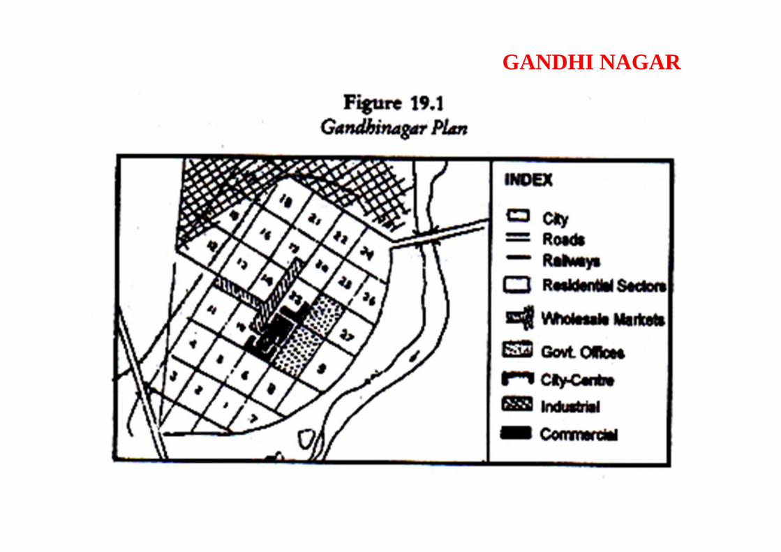
It is one of the most recently planned Indian cities. It is lying fifteen miles north ofAhmedabad on the right bank of Sabarmati River and is a new capital of Gujarat State.Its planning is based on the pattern of Le Corbusiar’s Chandigarh. The main objectivebehind its establishment was to relieve the overcrowding and polarization of the old city.Its total area of 21 sq miles is divided into 30 sectors, each one of 1 x 3/4 km rectangle.
It is flanked by light manufacturing industries besides residential areas and publicinstitutions. Gandhinagar is being planned in a manner to keep it off from all types ofpollution. It has for miles together rows of trees on both sides of the main road whichprovide ‘beauty, health and convenience’ to the residents. An area between sectors 7 to 9and the river bank is being developed as ‘recreational ground’, where a lake is providingit a scenic sight (Figure 19.1).
Gandhinagar Plan
Each of the sectors of Gandhinagar is independent where school, local shopping centre,hospital, etc., provide basic amenities to consumers of all levels. Highways and roads arejoined by sub-ways to keep the residential houses safe from vehicular traffic. School-children and tiny-tots have play field near their residences and they are within theirwalking distances. They need not to cross vehicular-roads for making use of theirschools, playfield and a shop.
GANDHI NAGAR

Creating the new city was given to Indian architects H. K. Mewada andPrakash M. Apte, both of whom had worked as apprenticesduring the construction of Chandigarh. The new city was constructed accordingto their plan and was named Gandhinagar after Mahatma Gandhi. Upon completionof the new city, the administrative capital of Gujarat was shifted from Ahmedabadto Gandhinagar.Gandhinagar is spread along the banks of the Sabarmati River, with the main citydesigned on the west bank of the river on approximately 42.9 km² of land. Since itfollows the river's path, the site is gently sloping, from north-east to south-west.Fine landscape lies along the west bank of the river, which gives the city amajestic appearance.
Gandhinagar is the only new capital of a state in India that was designedand planned by Indian town planners in service with the State Government.Since it is relatively new, it is also considered the "greenest" town in the world.Gandhinagar comprises thirty sectors, and it is a highly structured city with awell ordered street grid comprising blocks that are divided by two types of streets,similar to U.S. avenues and streets. Gandhinagar has "letter roads"(K, KH, G, GH, CH, CHH, and JA) and "number roads" (1, 2, 3, 4, 5, 6, and 7).The letter roads run parallel across the city perpendicular to the number roads,and both of the road types intersect each other to form a grid, with each block orsquare in the grid given a sector number. Each intersection is marked by signalnames such as CH1, CH2, CH3 or JA1, JA2. This provides a high degree oforganization and evenness to the various parts of the city.
GANDHI NAGAR

Being planned as the administrative capital of the state, current and future populationemployed in state government offices was distributed in 30 residential sectors around theState Assembly-Secretariat complex. In each residential sector some 50 per cent of theworking population would be government-employed. Plots on the periphery of each sectorwere designated for private and supporting population and made up the other 50 per cent.
The city was planned for a population of 150,000 but can accommodate double that figurewith increases in the floor space ratio from one to two in the areas reserved for privatedevelopment in all residential sectors. The river being the border on the east, and theindustrial area to the north, the most logical future physical expansion of the city wasenvisaged towards the north-west. To retain the identity of the city as a new town andcapital, the planners had provided for its growth away from the city of Ahmedabad, whichis to the south. Hence as a rational extension of the grid to the north-west the originalplanners had envisaged 30 additional residential sectors that could accommodate apopulation of 450,000.
GANDHI NAGAR

GANDHI NAGAR

Unlike Chandigarh, designed on barren lands with no sizeable existing human settlementnearby, the site of Gandhinagar is just 23km north of the flourishing city of Ahmedabad. Inorder to establish and maintain a separate identity for the new city, a surrounding areaconsisting of about 39 villages was brought under a Periphery Control Act (as inChandigarh) that permitted new development of farm houses only. The area laterconstituted a separate administrative district of Gandhinagar.The city is planned on the western bank of the river. Owing to constant militaryconfrontation with Pakistan, whose borders are close to the city, a large military presencewas required. The land acquired on the eastern bank, adjacent to national highway no.8,was therefore allotted to the border security force and a military cantonment. Consideringthe mostly south-west to north-east wind direction, the land to the north of the city wasallotted for the then biggest thermal power station and the adjacent areas were zoned forindustrial use. This area was distanced from the township by a 2,000ft wide green strip ofthick vegetation.
GANDHI NAGAR
GANDHI NAGAR

BHUBANESHWAR

BHUBANESHWAR

BHUBANESHWAR

BHUBANESHWAR

BHUBANESHWAR
CHANDIGARH
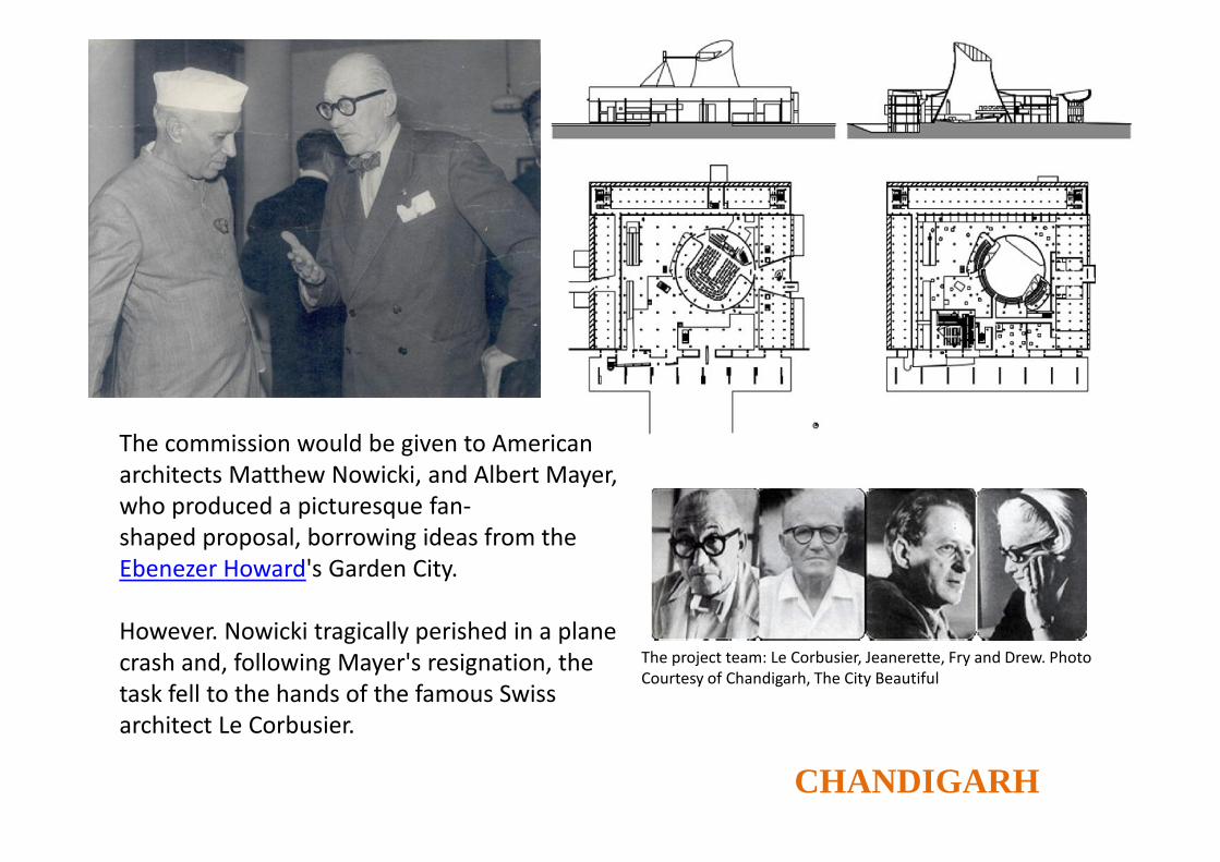
The commission would be given to Americanarchitects Matthew Nowicki, and Albert Mayer,who produced a picturesque fan-shaped proposal, borrowing ideas from theEbenezer Howard's Garden City.
However. Nowicki tragically perished in a planecrash and, following Mayer's resignation, thetask fell to the hands of the famous Swissarchitect Le Corbusier.
The project team: Le Corbusier, Jeanerette, Fry and Drew. PhotoCourtesy of Chandigarh, The City Beautiful
CHANDIGARH
The project team: Le Corbusier, Jeanerette, Fry and Drew. Photo Courtesy of Chandigarh, The City Beautiful
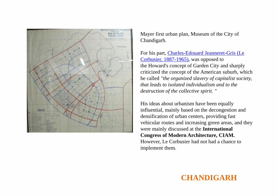
Mayer first urban plan, Museum of the City ofChandigarh.
For his part, Charles-Edouard Jeanneret-Gris (LeCorbusier, 1887-1965), was opposed tothe Howard's concept of Garden City and sharplycriticized the concept of the American suburb, whichhe called "the organized slavery of capitalist society,that leads to isolated individualism and to thedestruction of the collective spirit. "
His ideas about urbanism have been equallyinfluential, mainly based on the decongestion anddensification of urban centers, providing fastvehicular routes and increasing green areas, and theywere mainly discussed at the InternationalCongress of Modern Architecture, CIAM.However, Le Corbusier had not had a chance toimplement them.

CHANDIGARH

CHANDIGARH

CHANDIGARH

CHANDIGARH

CHANDIGARH

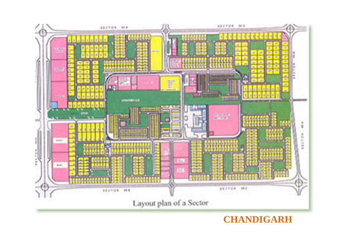
The plan, conceived for a city of 500,000, is based on a rectangular grid adaptedto field conditions. The basic unit was the "Sector", conceived as self-sufficient and introverted,subdivided into neighborhood units of about 150 families.
These sectors were linked by a network of streets called "the 7Vs". The "Vs" are pathways hierarchicallyorganized according to the intensity of the traffic flow that they support.Thus, V1 are national roads; V2 conduce to the special facilities; V3 are high speed avenues that cross the city leading to the local equipment V4, V5 are neighborhood ways, the V6, domestic paths, theV7 are pedestrian paths and the V8, subsequently added, are bikeways(Le Corbusier joked: "the 7Vs that are actually 8").
Each 1200 * 800 meters sector is linked to a V2 or V3 high-speed way.It is crossed from east to west by a V4 shopping street, which connects to other adjacent sectors,and to a V5 neighborhood way from north to south. V7 walkways connect to the fringes of parksand green areas.
CONCEPT
Based on 4 main functions (living, working, moving and keeping a healthy body and spirit),the Corbusian proposal makes an analogy between Chandigarh and the human body:the head is the Capitol (Sector 1), the heart the Central Area (Sector 17), the lungs were the Leisure Valley,parks and green areas, the brain, the universities and schools, the circulatory system were 7Vs waysand the digestive system, the industry.
CHANDIGARH
CHANDIGARH

CHANDIGARH

In the 1930s, Le Corbusier expanded and reformulated his ideas on urbanism, eventuallypublishing them in La Ville radieuse (The Radiant City) of 1935. Within the radiant city,there are government buildings, business center, railroad station and air terminal, hotels,housing, factories, warehouses, and heavy industries. The city center is residential zone,with business center and insutrial section on either side. By doing so, the internal travelcan be diminished by half. Each housing units is intended for 2700 residents. Each ofthese units can provided with its individual set of services, directly connected withfamily life: communal services (catering and household supplies), nursery, kindergarten,open-air playground in the park, primary school in the park. Between the ages of 1 and14, children will have all necessary educational establishments outside their own frontdoor, in the park.
Comments:Le Corbusier opposed the city authorities’ proposal of making suburban garden-cities(150-300 people to the hectare). He believed the city should pile the city in on top ofitself and increase its population density to 1,000. By eliminating the suburbs, andbanning those garden-cities with their mock nature, there would be no transportationcrisis. The idea of building radiant city is to build a green city with nature brought insidethe walls of Paris. The entire ground surface will give back to pedestrians. Since theapartment houses are all up in the air, raised on pilotis, it will be possible to walk acrossthe city in any direction. In other words: no pedestrian will ever meet an automobile
RADIANT CITY

RADIANT CITY

City of tomorrow
Le Corbusier’s proposal for a modern city ofthree million inhabitants, with no fi xedlocation, 1922. (FLC)
“Speed lies on this side of mere dreams: it is a brutal necessity.The conquest of speed has always been the dream of mankind, yet it has only taken shape in the last onehundred years. Before then the stages in the conquest of speed were incredibly distant one from the other. Foran immense period of time, man could only move at the rate at which his own limbs would take him, and allhis progress, apart from sails, consisted in using the speed of animals.”1 This is how in 1924, while discussing idealmetropolises in the pages of his book City of Tomorrow and ItsPlanning, Le Corbusier proclaimed his unconditional faith in thespeed of automobiles.