Challenges in the Integration of Light Rail and Land … RESEARCH PAPERS Challenges in the...
9
ORIGINAL RESEARCH PAPERS Challenges in the Integration of Light Rail and Land Use: A Case Study of Yizhuang Line in Beijing Haishan Xia 1 • Chen Shen 2 • Chun Zhang 1,3 • Xinhao Wang 3,4 • Daizong Zhang 1 Received: 1 February 2017 / Revised: 21 March 2017 / Accepted: 25 March 2017 / Published online: 18 April 2017 Ó The Author(s) 2017. This article is an open access publication Abstract Transit-oriented development (TOD) is advo- cated by urban planners as a tool to promote transportation and land use integration, and it has especially been applied in new town developments in Chinese cities. Since 2000, urban metro system construction in Beijing has accelerated and many new towns in suburban areas have emerged due to rail transit connections with the central city. This paper is a case study of Yizhuang new town, which is located in the southeast suburban area of Beijing. It explores whether light rail is successful in promoting transportation and land use integration. First, by comparing the land use within a 1 km radius of three rail stations, findings suggest that the TOD model in terms of land use may not be implemented. Second, by tracing land use changes over time, we found that commercial functions are critical to support TOD development. Third, the mismatch of urban functions between low-skilled labor employment opportunities and high-skilled residential neighborhoods emphasizes the failure of planned reverse commuting patterns. In conclu- sion, our findings suggest that without a proper land use policy, TOD based on light rail only may not be a suc- cessful model in the case of Yizhuang new town. The policy implication is that the planning code of land use should be more flexible and adaptable, in order to promote the integration of transportation and land use in a syner- getic way. Keywords Transit-oriented development Á Light rail Á Integration Á Beijing Á Yizhuang 1 Introduction The concept of transit-oriented development (TOD) can be traced to American cities around the turn of the twentieth century when trams, buses, and streetcars became the dominating mode of urban transportation. Most urbanized areas were situated along transit lines. As automobiles became the main mode of transportation, especially after World War II, middle-class families consequently moved to suburban areas, leading to a substantial decline of public transportation facilities. Driving to work gradually becomes a necessary part of typical American life. In response to the problems posed by increased car use, such as traffic congestion, increased energy consumption, and air pollution, several American cities invested in public transit such as light rails. Under these circumstances, TOD emerged as the main model of transportation development [1]. TOD advocates that neighborhoods around transit stations should have high-density and mixed land uses [2, 3]. Peter Calthorpe popularized the term TOD in his 1993 book, ‘‘The New American Metropolis,’’ to encourage public transportation and mixed land use in nearby neighborhoods (Calthorpe 2001). Other scholars later developed more TOD defini- tions and adopted TOD principles in their practice (Table 1). For example, Bernick and Cerbvero pointed out & Chun Zhang [email protected] 1 School of Architecture and Design, Beijing Jiaotong University, Beijing, China 2 School of Civil Engineering, Beijing Jiaotong University, Beijing, China 3 UC-BJTU Future City Co-Lab, Beijing, China 4 School of Design, Architecture, Art and Planning, University of Cincinnati, Cincinnati, OH, USA Editors: Haishan Xia, Chun Zhang 123 Urban Rail Transit (2017) 3(1):45–53 DOI 10.1007/s40864-017-0055-3 http://www.urt.cn/
Transcript of Challenges in the Integration of Light Rail and Land … RESEARCH PAPERS Challenges in the...
ORIGINAL RESEARCH PAPERS
Challenges in the Integration of Light Rail and Land Use:A Case Study of Yizhuang Line in Beijing
Haishan Xia1 • Chen Shen2 • Chun Zhang1,3 • Xinhao Wang3,4 • Daizong Zhang1
Received: 1 February 2017 / Revised: 21 March 2017 / Accepted: 25 March 2017 / Published online: 18 April 2017
� The Author(s) 2017. This article is an open access publication
Abstract Transit-oriented development (TOD) is advo-
cated by urban planners as a tool to promote transportation
and land use integration, and it has especially been applied
in new town developments in Chinese cities. Since 2000,
urban metro system construction in Beijing has accelerated
and many new towns in suburban areas have emerged due
to rail transit connections with the central city. This paper
is a case study of Yizhuang new town, which is located in
the southeast suburban area of Beijing. It explores whether
light rail is successful in promoting transportation and land
use integration. First, by comparing the land use within a
1 km radius of three rail stations, findings suggest that the
TOD model in terms of land use may not be implemented.
Second, by tracing land use changes over time, we found
that commercial functions are critical to support TOD
development. Third, the mismatch of urban functions
between low-skilled labor employment opportunities and
high-skilled residential neighborhoods emphasizes the
failure of planned reverse commuting patterns. In conclu-
sion, our findings suggest that without a proper land use
policy, TOD based on light rail only may not be a suc-
cessful model in the case of Yizhuang new town. The
policy implication is that the planning code of land use
should be more flexible and adaptable, in order to promote
the integration of transportation and land use in a syner-
getic way.
Keywords Transit-oriented development � Light rail �Integration � Beijing � Yizhuang
1 Introduction
The concept of transit-oriented development (TOD) can be
traced to American cities around the turn of the twentieth
century when trams, buses, and streetcars became the
dominating mode of urban transportation. Most urbanized
areas were situated along transit lines. As automobiles
became the main mode of transportation, especially after
World War II, middle-class families consequently moved
to suburban areas, leading to a substantial decline of public
transportation facilities. Driving to work gradually
becomes a necessary part of typical American life. In
response to the problems posed by increased car use, such
as traffic congestion, increased energy consumption, and
air pollution, several American cities invested in public
transit such as light rails.
Under these circumstances, TOD emerged as the main
model of transportation development [1]. TOD advocates
that neighborhoods around transit stations should have
high-density and mixed land uses [2, 3]. Peter Calthorpe
popularized the term TOD in his 1993 book, ‘‘The New
American Metropolis,’’ to encourage public transportation
and mixed land use in nearby neighborhoods (Calthorpe
2001). Other scholars later developed more TOD defini-
tions and adopted TOD principles in their practice
(Table 1). For example, Bernick and Cerbvero pointed out
& Chun Zhang
1 School of Architecture and Design, Beijing Jiaotong
University, Beijing, China
2 School of Civil Engineering, Beijing Jiaotong University,
Beijing, China
3 UC-BJTU Future City Co-Lab, Beijing, China
4 School of Design, Architecture, Art and Planning, University
of Cincinnati, Cincinnati, OH, USA
Editors: Haishan Xia, Chun Zhang
123
Urban Rail Transit (2017) 3(1):45–53
DOI 10.1007/s40864-017-0055-3 http://www.urt.cn/
that bus stations should be within 1/4 miles from resi-
dential locations in order to create a compact and multi-
functional neighborhood [4]. Similar to planned unit
development (PUD) and traditional neighborhood planning
(TND), TOD promotes walkability [5]. The New Urbanism
movement in the 1990s removed debate of whether or not
to promote TOD in urban design and neighborhood plan-
ning. Empirical studies support the advantages of TOD
neighborhoods compared with other suburban neighbor-
hoods: Residents drive less by 33% [6] and have more
social interaction with neighbors [7] than those in low-
density, cul-de-sac neighborhoods. Many state transporta-
tion bureaus also adopted TOD. For example, Maryland
Department of Transportation promotes high-density
development, accessible facilities and amenities, and bus
or rail transportation systems at walking distance [8].
California Department of Transportation highlights land
use development and commercial facilities around trans-
portation facilities and promotes a residential–employ-
ment–commercial integrated land use model [9]. TOD not
only improves the use of high-capacity transportation, but
also encourages mixed land use and building style diver-
sification. In conclusion, TOD provides more travel
options of a neighborhood the choices of life style. It helps
to reduce car use and thus also decreases greenhouse gas
emissions and improves air quality. According to the New
Urbanism advocators, TOD also promotes healthier and
sustainable life style because it encourages citizens to shift
from driving to walking [10].
TOD was introduced in China in the late 1990s against
the background of rapid urbanization and suburbanization
[11]. While large-scale affordable housing communities
emerged on the outskirt of large cities [12], urban rail
transportation infrastructure became critical given that it
provides the essential connection between suburban hous-
ing and urban center jobs [13]. In particular, among
middle- and low-income groups living in affordable
housing, rail transportation became the main affordable
travel mode supporting large volumes of mass transit.
TOD has been widely used in China and remains pop-
ular in urban planning practice, especially with the accel-
eration of rail transit development. In contrast with most of
American cities, Chinese cities generally have higher
density, and as such they are very suitable cases for the
application of the TOD model [8]. Also, the car-oriented
development model does not have a deep-rooted historical
influence in most Chinese cities, which makes the TOD
principles more easily accepted by Chinese planners and
decision makers [14].
On a national scale, many cities emphasize TOD in their
comprehensive planning, such as Beijing, Dalian, Shen-
zhen, Wuhan, and Tianjin [15]. In 2016, the Ministry of
Housing and Urban–Rural Development (HURD), the
National Development and Reform Commission, and the
Ministry of Finance jointly selected 127 towns in China as
the first group of national featured towns [16]. The TOD
model was highlighted by both urban planners and gov-
ernment officials in the featured town planning and urban
designs.
Some scholars point out difficulties in fully realizing the
TOD model in the short run. For example, in cases of
extremely rapid urbanization, public transit facility con-
struction usually lags far behind mass-produced suburban
housing projects [17]. An extremely high passenger vol-
ume during peak hour is described as a failure of the ful-
fillment of TOD [17].
To contribute to the literature of assessing TOD in the
context of contemporary urbanization in China, this paper
analyzes the connection of urban rail transit and urban
planning, using the light rail line in Yizhuang as a case.
Yizhuang is selected because it is the only New Town
connected to the city center with a rail transit
Table 1 Literature on TOD in the USA
TOD in the USA
Peter Calthorpe [1] TOD is a kind of mixed land use of the community and plays a role in encouraging public transport
objectively
Bernick and Cerbvero [2] TOD is a compact, functional mix of community, with a public transport site for community centers, through
a reasonable design, to encourage people to use less cars, more public transport. Bus stations are the
centers of communities within a 400-m radius
Freilich [3] TOD is similar to the new development (neo-traditional development, NTD); it aims to improve use of high-
capacity transportation, as well as new city development mode, mixed use of land, and diversification of
architectural design to replace the monotonous form of land use
Maryland Department of
Transportation [4]
TOD has a relatively high density of development, including living, employment, commercial, and public
facilities, such as the function of mixing in a bus or rail transport site within walking distance
California Department of
Transportation [5]
TOD is a moderate- or high-density land use around the main public transportation site, usually will include
living, employment, commercial facilities within the scope of mixed arrangement, and is suitable for
walking, and the coordination of public transport facilities
46 Urban Rail Transit (2017) 3(1):45–53
123
infrastructure, which makes Yizhuang a suitable case to
assess the success of the TOD model. The purpose of the
study is to clarify use and expectations of transit-oriented
development in China.
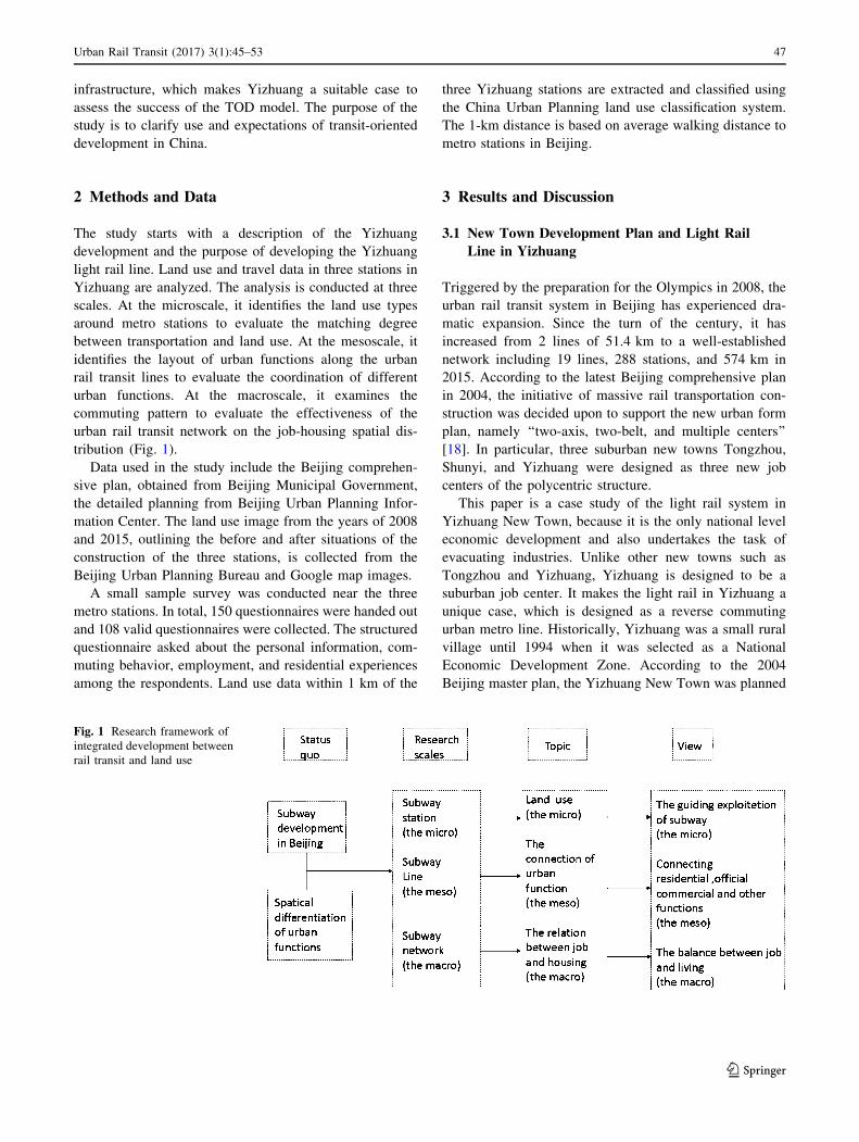
2 Methods and Data
The study starts with a description of the Yizhuang
development and the purpose of developing the Yizhuang
light rail line. Land use and travel data in three stations in
Yizhuang are analyzed. The analysis is conducted at three
scales. At the microscale, it identifies the land use types
around metro stations to evaluate the matching degree
between transportation and land use. At the mesoscale, it
identifies the layout of urban functions along the urban
rail transit lines to evaluate the coordination of different
urban functions. At the macroscale, it examines the
commuting pattern to evaluate the effectiveness of the
urban rail transit network on the job-housing spatial dis-
tribution (Fig. 1).
Data used in the study include the Beijing comprehen-
sive plan, obtained from Beijing Municipal Government,
the detailed planning from Beijing Urban Planning Infor-
mation Center. The land use image from the years of 2008
and 2015, outlining the before and after situations of the
construction of the three stations, is collected from the
Beijing Urban Planning Bureau and Google map images.
A small sample survey was conducted near the three
metro stations. In total, 150 questionnaires were handed out
and 108 valid questionnaires were collected. The structured
questionnaire asked about the personal information, com-
muting behavior, employment, and residential experiences
among the respondents. Land use data within 1 km of the
three Yizhuang stations are extracted and classified using
the China Urban Planning land use classification system.
The 1-km distance is based on average walking distance to
metro stations in Beijing.
3 Results and Discussion
3.1 New Town Development Plan and Light Rail
Line in Yizhuang
Triggered by the preparation for the Olympics in 2008, the
urban rail transit system in Beijing has experienced dra-
matic expansion. Since the turn of the century, it has
increased from 2 lines of 51.4 km to a well-established
network including 19 lines, 288 stations, and 574 km in
2015. According to the latest Beijing comprehensive plan
in 2004, the initiative of massive rail transportation con-
struction was decided upon to support the new urban form
plan, namely ‘‘two-axis, two-belt, and multiple centers’’
[18]. In particular, three suburban new towns Tongzhou,
Shunyi, and Yizhuang were designed as three new job
centers of the polycentric structure.
This paper is a case study of the light rail system in
Yizhuang New Town, because it is the only national level
economic development and also undertakes the task of
evacuating industries. Unlike other new towns such as
Tongzhou and Yizhuang, Yizhuang is designed to be a
suburban job center. It makes the light rail in Yizhuang a
unique case, which is designed as a reverse commuting
urban metro line. Historically, Yizhuang was a small rural
village until 1994 when it was selected as a National
Economic Development Zone. According to the 2004
Beijing master plan, the Yizhuang New Town was planned
Fig. 1 Research framework of
integrated development between
rail transit and land use
Urban Rail Transit (2017) 3(1):45–53 47
123

as a high-tech industrial center and an advanced manu-
facturing center, with a total population of 300,000 in 2010
and estimated population of 700,000 in 2020; it is the result
of evacuation of both jobs and population from the city
center. The light rail line is designed to be the essential
transportation facility to draw employees from urban center
to economic development zone in the new town, achieving
the objectives of population evacuation.
The Yizhuang line commenced operation in 2010 and
functions as an extension of metro line 5. Yizhuang light
rail starts at the Songjiazhuang metro station where it
connects to the subway line 10, stretching 23.3 km toward
southeast to the edge of Tongzhou district. It has 13 sta-
tions and passes through the central area of Yizhuang New
town (Fig. 2).
Along the Yizhuang light rail, three stations are inside
Yizhuang New Town. Wanyuanjie station is one of the
earliest stations in the old administrative center of Yiz-
huang. Rongjingdongjie station is near the new adminis-
trative center. Jinghailu station is located in the new
developed area near the end terminal (Fig. 3).
Both the 2004 master plan and detailed planning high-
light TOD principles, which advocates arranging land use
density and land use types according to the distance to light
rail stations. Commercial buildings are located in the inner
circle just outside the stations, office and residential
buildings constitute the outer layer of the circle along
streets, while industrial buildings are located on the
periphery of the 1-km radius area. The intent of the plan-
ning is to integrate transportation infrastructure with sur-
rounding land uses and facilities and to provide better
accessibility and convenience for rail transit users.
3.2 Comparison of Land Use Between Plan
and Reality
Microscale comparison of the land use within a 1-km
radius around the metro station highlights the differences
between plan and reality. Although the original plan was
prepared according to TOD principles, not all of the actual
land use follows the plan. Figure 4 illustrates the planned
land uses in the 2004 master plan and the observed land
uses in 2015 for the three stations. A visual comparison
shows that the development in Wanyuanjie (Fig. 4a) and
Rongjingdongjie (Fig. 4b) stations mostly followed the
plan. However, Jinghailu station (Fig. 4c) turned out to be
a low-density, manufactural function-oriented industrial
zone.
The inconsistency between planned and actual land uses
reveals the difference in TOD performance in new town
development in Chinese cities. Without suitable planning
implementation tools, the area around light rail station
cannot naturally grow in a TOD way. It also shows that in
the early stage of new town development, new develop-
ment may not automatically take place near transportation
facilities, which may have negative consequences for
Fig. 2 Rapid development of urban rail transportation in Beijing and Yizhuang light rail line
48 Urban Rail Transit (2017) 3(1):45–53
123

future TOD planning. The failure in fulfilling the TOD
model around Jinghailu station, suggests that industrial-
oriented development may not effectively comply with the
TOD model in Chinese cities.
3.3 Land Use Change Over Time Around Metro
Station
Transportation planners and urban planners tend to assume
that with the opening of an urban metro station, the land
use of the surrounding area will develop naturally
according to planned TOD models, and that any mismatch
between planning and reality is only temporary. In partic-
ular, commercial facilities and amenities are usually
neglected in the early stage of planning. By comparing the
land use pattern in 2008 and 2015 by Google map, this
section traces the land use change over time around urban
rail stations.
By examining land use change from 2008 to 2015 within
a 1-km radius around three stations, our findings suggest
that a certain proportion of commercial land is critical for
the TOD model (Table 2). For example, there are 14.52%
commercial land within the 1-km radius around
Wanyuanjie, which provides enough space for various
facilities and amenities such as shopping centers, conve-
nient stores, restaurants, bars, and cafes. In contrast, com-
mercial land proportion is only 3.62% near
Rongjingdongjie. In the last case of Jinghailu, there is no
commercial land around the station which makes boring
landscape. The comparison among three stations shows the
importance of commercial land as the attractive core in
TOD model.
Land use change from 2008 to 2015 reflects different
influence of urban rail stations. In the area around the first
case, Wanyuanjie commercial land increased between 2008
and 2015, making it into a multi-functional center includ-
ing business, commercial, and recreation (Fig. 5a). In the
case of Wenjindongjie, residential and administrative land
increased, making it a semi-employment, semi-residential
area. At the Jinghailu station, industrial land increased
making it a manufacturing center (Fig. 5b). These findings
show that even with similar urban rail transit stations along
the Yizhuang line, the impact of transportation facilities on
land use change may be significantly different (Fig. 5c).
With suitable urban planning and proper urban design,
more facilities and amenities may develop around rail
stations with time and thus increase the livability and
vitality of the neighborhood. However, these facilities and
amenities might not naturally appear without featured
public space reserve ahead and a flexible zoning code.
3.4 Urban Functions and Commuting Pattern
as Suburban New Town
As one of the suburban new towns, Yizhuang is planned to
be an employment center which enables the evacuation of
both industry and population from the central city. The
light rail line is the essential transportation facility to draw
employees from the urban center to the economic devel-
opment zone in the new town, achieving the objectives of
population evacuation.
However, in the perspective of urban functions, there is
large low-density industrial land concentrated along the
light rail line, which is not conducive in making Yizhuang
New Town an attractive employment center (Fig. 6), as it
mainly provides low-skilled job opportunities, while failing
to provide job opportunities for the high-skilled residents in
the surrounding neighborhoods. Thus, as an economic and
technological development zone, it attracts employees
either from the urban center or local neighborhood.
Fig. 3 Location and study area
of the 1 km land use around
station
Urban Rail Transit (2017) 3(1):45–53 49
123
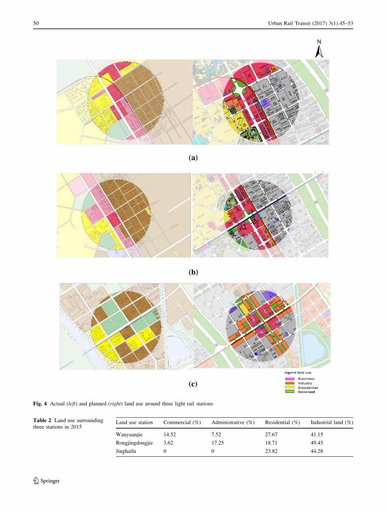
Fig. 4 Actual (left) and planned (right) land use around three light rail stations
Table 2 Land use surrounding
three stations in 2015Land use station Commercial (%) Administrative (%) Residential (%) Industrial land (%)
Wanyuanjie 14.52 7.52 27.67 41.15
Rongjingdongjie 3.62 17.25 18.71 49.45
Jinghailu 0 0 23.82 44.28
50 Urban Rail Transit (2017) 3(1):45–53
123

The findings from the small-scale questionnaire col-
lected near the light rail stations support the assumption of
a mismatch between low-skilled job opportunities and
high-skilled residential neighborhood. Among the total 108
samples, 50.9% of local residents still work in the city
center, while in terms of local employment rate, 46% of
local employees come from other, more distant suburban
neighborhoods (Fig. 7). The gap between the ideal and the
actual commuting patterns implies that the objective of
making Yizhuang New Town a job center has not been
successful. Ideally, most local residents should commute in
a reverse way to the suburban industrial areas, while a
limited volume of local residents commute to the city
center. However, the actual situation in Yizhuang suggests
that most of the residents still commute to the urban city
center for employment, while the industrial-oriented eco-
nomic development zone attracts only a small proportion of
commuters from the city center and surrounding suburban
neighborhoods (Fig. 7).
In addition, the small-scale questionnaire survey reveals
that the Yizhuang light rail line does not fulfill its purpose
to transport citizens from the center to the suburbs. In
contrast, residents living in the suburb instead choose the
subway to transit to the city center for employment. The
mismatch between the ideal and real commuting patterns
reveals the failure of light rail as a method to evacuate job
opportunities to Yizhuang New Town. Instead, the findings
of this case study suggest that the light rail line aggravates
traffic congestion of the city center, in conflict with the
original master plan of Beijing.
4 Conclusion
While transit-oriented development originated in the USA,
it is also promoted in China, especially for new town
developments. With the trend of rapid urban rail trans-
portation construction, it is generally assumed that the
existence of transportation facilities will automatically lead
to a TOD model. Selecting Yizhuang New Town in sub-
urban Beijing, this paper evaluates the performance of light
rail in Yizhuang in supporting the integration between
transportation and land use. This paper will also explore
whether attractive job center emerges and evacuates pop-
ulation and jobs as the master plan advocated in the case of
Yizhuang.
Yizhuang in Beijing is a suitable case for studying the
impact of light rail systems on land use in a suburban new
town. The Yizhuang light rail line is planned to support the
city center and near-suburban residents commuting to far
suburban new town. Exploring the GIS-based spatial
analysis, this paper compares the planned and actual pat-
terns of land use within a 1-km radius area of three stations
along the Yizhuang line. It finds that the gap between plan
and reality in the land use pattern is significant, especially
around the Jinghailu station at the end of the rail line,
where an industrial-oriented model is adopted. The land
use change over time also reveals the importance of com-
mercial land in supporting a successful TOD model.
Without attractive facilities and amenities provided by
commercial land, the daily needs of resident and employ-
ees are not met. Additionally, the planned reverse com-
muting pattern fails to realize the aims of evacuation
Fig. 5 Land use in 2008 (left) and 2015 (right) around three light rail
stations
Urban Rail Transit (2017) 3(1):45–53 51
123

population and jobs from city center, due to the mismatch
between the existing low-skilled job opportunities and the
high-skilled residents in the area as illustrated in Fig. 7.
The policy implication for this study is that the urban
planning code for land use should be flexible and adapt-
able to the transportation infrastructure in TOD model.
While there are many successful cases in China, the case of
Yizhuang may not be considered as one. Our findings
suggest that applying the concept of TOD into light rail
development is not entirely straightforward, and instead an
integrated approach between rail transportation and land
use may be more successful. Proper land use is essential in
successful TOD development, and to single-handedly focus
on urban rail line development does not automatically lead
to a successful TOD model in surrounding areas. Sur-
rounding area naturally grows in a TOD way. Transporta-
tion and land use coordination are critical in implementing
integrated planning. Additional studies on activity based
and demand driven may be needed to further explore the
needs for transportation and land use integration.
Fig. 6 Land use map around
light rail line of Yizhuang
Fig. 7 Planned (above) and
actual (below) commuting
pattern
52 Urban Rail Transit (2017) 3(1):45–53
123
Acknowledgements This study was supported by the National Nat-
ure Science Foundation of China (41401651, 51678029).
Open Access This article is distributed under the terms of the
Creative Commons Attribution 4.0 International License (http://crea
tivecommons.org/licenses/by/4.0/), which permits unrestricted use,
distribution, and reproduction in any medium, provided you give
appropriate credit to the original author(s) and the source, provide a
link to the Creative Commons license, and indicate if changes were
made.
References
1. Dueker K, Bianco M (1999) Light-rail-transit impacts in Port-
land: the first ten years. Transp Res Rec J Transp Res Board
1685:171–180
2. Bookout W (1992) Neotraditional town planning: a new vision
for the suburbs? Urban Land 51(1):20–26
3. Bookout W (1992) Neotraditional town planning: cars, pedestri-
ans, and transit. Urban Land 51(2):10–15
4. Bernick M, Cervero R (1997) Transit villages in the 21st century.
McGraw-Hill, New York, pp 377–398
5. Calthorpe PG, Fulton WB (eds) (2001) The regional city: plan-
ning for the end of sprawl. Books. In: The regional city: planning
for the end of sprawl. Island Press, New York, pp 107–139
6. Ewing R, Rong F (2008) The impact of urban form on US resi-
dential energy use. Hous Policy Debate 19(1):1–30
7. Dittmar H, Ohland G (eds) (2012) The new transit town: best
practices in transit-oriented development. Island Press, New
York, pp 99–111
8. Cervero R, Arrington GB, Smith-Heimer J et al (2004) Transit
Oriented Development in America: experiences, challenges, and
prospects, TCRP report 102. Transportation Research Board,
Washington
9. Brown Barbara B, Cropper Vivian L (2001) New urban and
standard suburban subdivisions: evaluating psychological and
social goals. J Am Plan Assoc 67(4):402–419
10. William R (2008) From local to global: one hundred years of
neighborhood planning. J Am Plan Assoc 75(2):209–230
11. Lin JJ, Gau CC (2006) A TOD planning model to review the
regulation of allowable development densities around subway
stations. Land Use Policy 23(3):353–360
12. Ministry of Housing and Urban–Rural Development (2016)
Notice of the Ministry of Housing and Urban–Rural Develop-
ment, the National Development and Reform Commission, and
the Ministry of Finance on the Development of Featured Towns,
No. 147
13. Parker T et al (2002) Statewide transit-oriented development
study: factors for success in California. Final report. California
Department of Transportation, Urban Land Institute, Washington
14. Zhao P, Lu B (2009) Transportation implications of metropolitan
spatial planning in mega-city Beijing. Int Dev Plan Rev
31(3):235–261
15. Zhang C, Man J (2015) Examining job accessibility of the urban
poor by urban metro and bus: a case study of Beijing. Urban Rail
Transit 1(4):183–193
16. Wang J, Jin F, Mo H et al (2007) Research on review of TOD
development mode analysis. Transp Transp Acad J 12(z2):19–22
(in Chinese)17. Ma L, Wu F (eds) (2005) Restructuring the Chinese city: diverse
processes and reconstituted spaces. In: Restructuring the Chinese
city: changing society, economy and space. Routledge, London,
pp 1–20
18. Beijing Master Planning (2004) Final Report Beijing municipal
government and Beijing urban planning Bureau, Beijing. http://
zhengwu.beijing.gov.cn/ghxx/ztgh/. Retrieved on Mar 1 2017.
Urban Rail Transit (2017) 3(1):45–53 53
123