RBF-FD: New Computational Opportunities in the Geo-Fluid ...
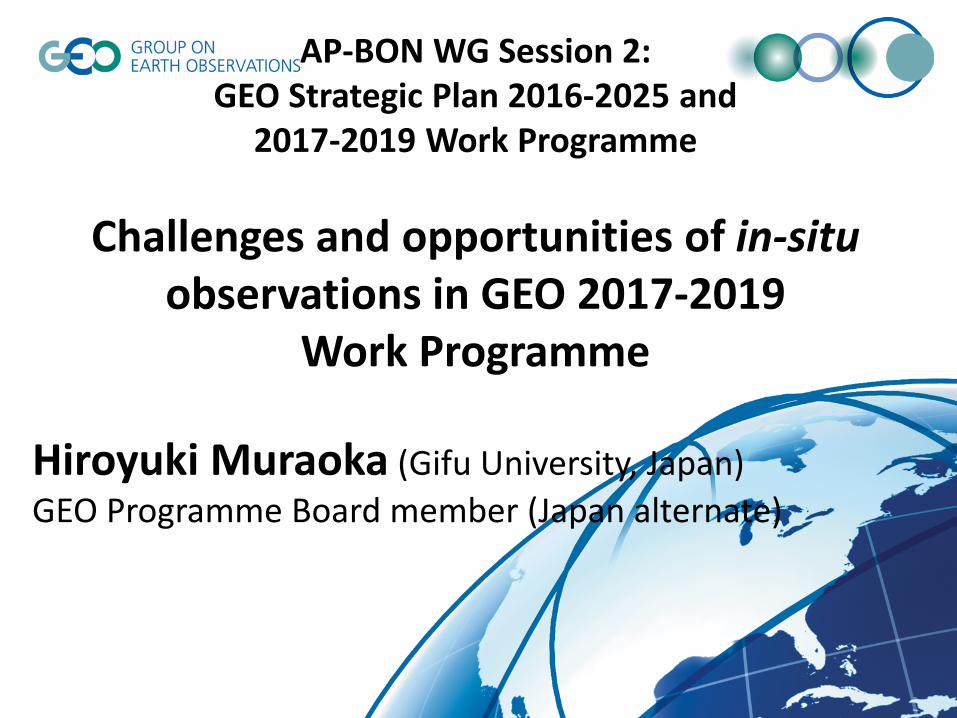
AP-BON WG Session 2: GEO Strategic Plan 2016-2025 and
2017-2019 Work Programme
Challenges and opportunities of in-situ observations in GEO 2017-2019
Work Programme
Hiroyuki Muraoka (Gifu University, Japan) GEO Programme Board member (Japan alternate)
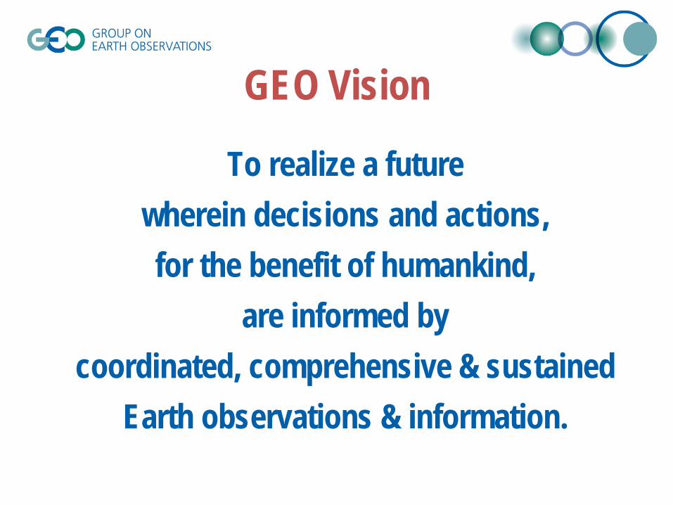
GEO Vision
To realize a future wherein decisions and actions, for the benefit of humankind,
are informed by coordinated, comprehensive & sustained
Earth observations & information.
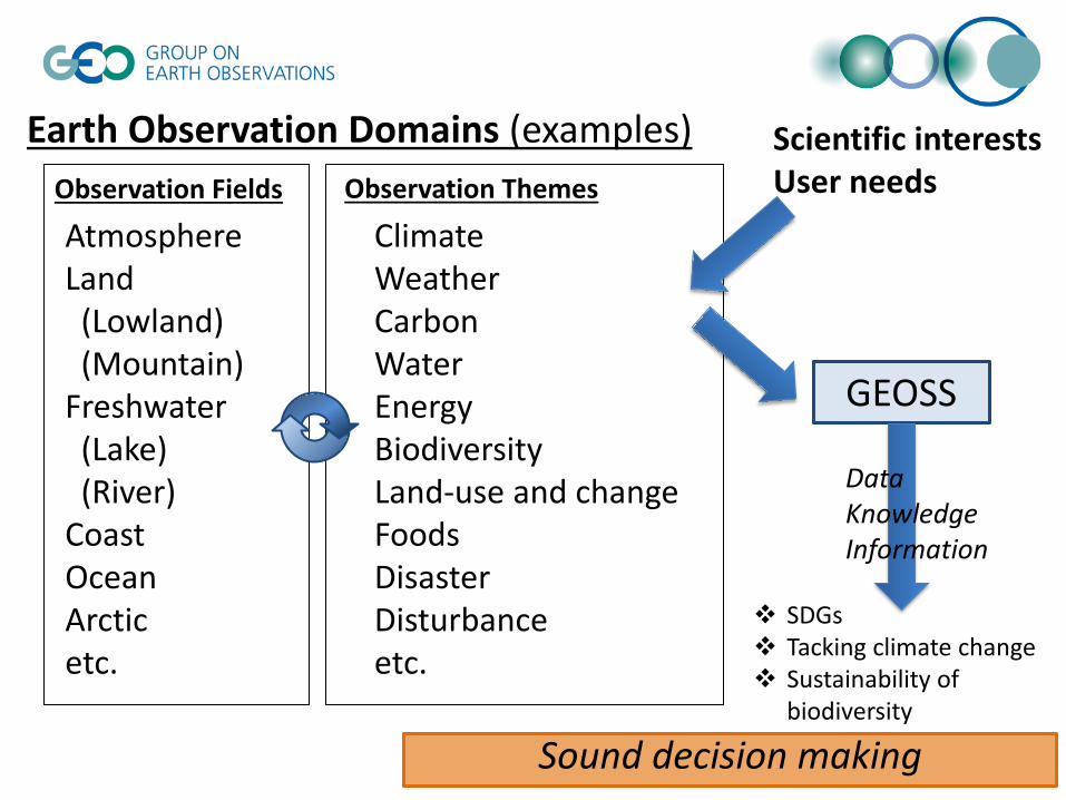
Earth Observation Domains (examples)
Atmosphere Land (Lowland) (Mountain) Freshwater (Lake) (River) Coast Ocean Arctic etc.
Climate Weather Carbon Water Energy Biodiversity Land-use and change Foods Disaster Disturbance etc.
Observation Fields Observation Themes
GEOSS
Data Knowledge Information
Sound decision making
Scientific interests User needs
SDGs Tacking climate change Sustainability of
biodiversity
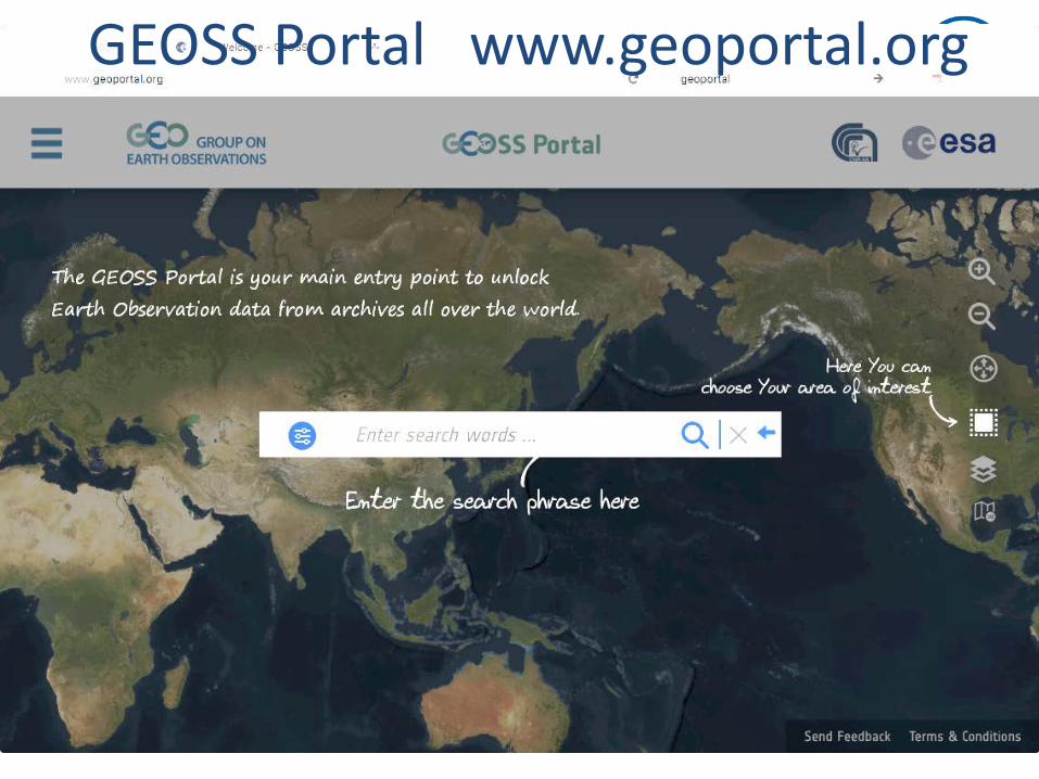
GEOSS Portal www.geoportal.org
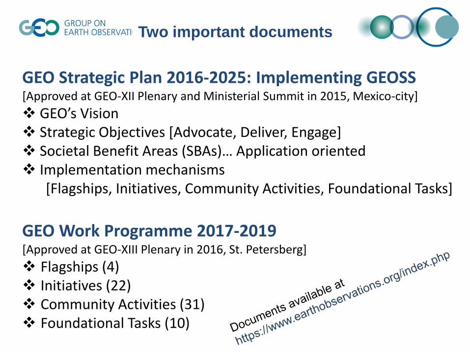
GEO Strategic Plan 2016-2025: Implementing GEOSS [Approved at GEO-XII Plenary and Ministerial Summit in 2015, Mexico-city] GEO’s Vision Strategic Objectives [Advocate, Deliver, Engage] Societal Benefit Areas (SBAs)… Application oriented Implementation mechanisms [Flagships, Initiatives, Community Activities, Foundational Tasks] GEO Work Programme 2017-2019 [Approved at GEO-XIII Plenary in 2016, St. Petersberg] Flagships (4) Initiatives (22) Community Activities (31) Foundational Tasks (10)
Two important documents
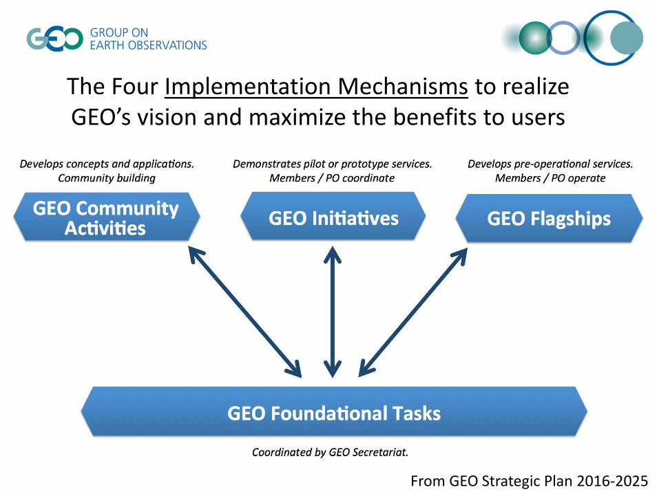
The Four Implementation Mechanisms to realize GEO’s vision and maximize the benefits to users
From GEO Strategic Plan 2016-2025

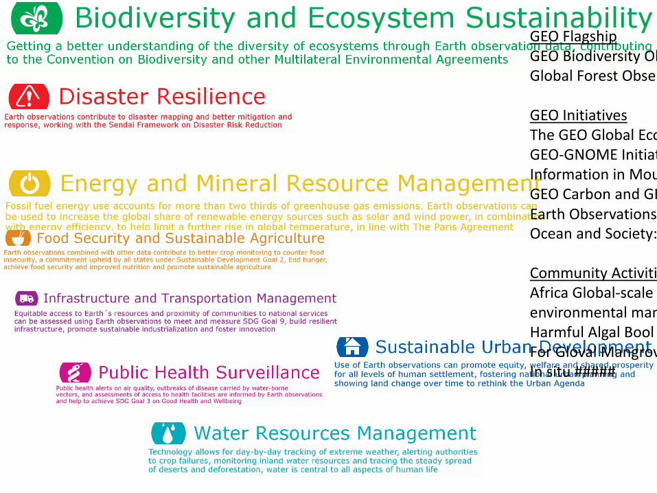
GEO Flagships GEO Biodiversity Observation network (GEO BON) Global Forest Observation Initiative (GFOI)
GEO Initiatives The GEO Global Ecosystem Initiative (GEO-ECO) GEO-GNOME Initiative: GEO Global Network for Observation and Information in
Mountain Environments GEO Carbon and GHG Initiative Earth Observations for Ecosystem Accounting (EO4EA) Ocean and Society: Blue Planet
Community Activities Africa Global-scale Geochemical Baselines for mineral resource and environmental
management: Capacity-building phase Harmful Algal Bloom (HAB) Early Warning System For Global Mangrove Monitoring
Foundational Tasks GEOSS development and GCI operations
GEOSS in-situ observation resources User needs and gap analysis
SBA: Biodiversity and Ecosystem Sustainability Related activities (examples)
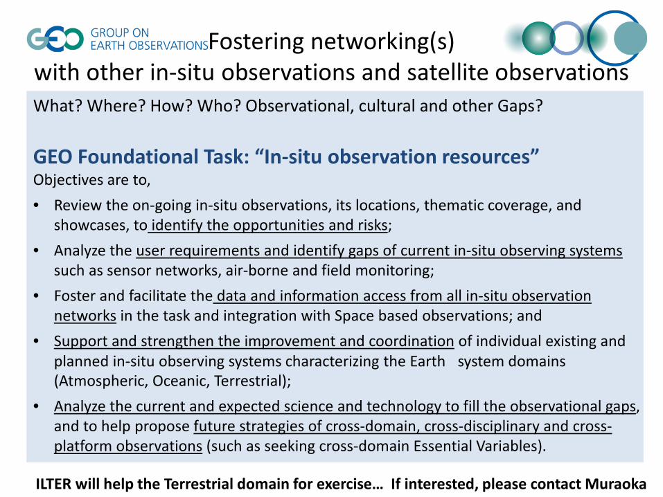
Fostering networking(s) with other in-situ observations and satellite observations What? Where? How? Who? Observational, cultural and other Gaps? GEO Foundational Task: “In-situ observation resources” Objectives are to, • Review the on-going in-situ observations, its locations, thematic coverage, and
showcases, to identify the opportunities and risks; • Analyze the user requirements and identify gaps of current in-situ observing systems
such as sensor networks, air-borne and field monitoring; • Foster and facilitate the data and information access from all in-situ observation
networks in the task and integration with Space based observations; and • Support and strengthen the improvement and coordination of individual existing and
planned in-situ observing systems characterizing the Earth system domains (Atmospheric, Oceanic, Terrestrial);
• Analyze the current and expected science and technology to fill the observational gaps, and to help propose future strategies of cross-domain, cross-disciplinary and cross-platform observations (such as seeking cross-domain Essential Variables).
ILTER will help the Terrestrial domain for exercise… If interested, please contact Muraoka

Ecosystem and land-use types Vegetation structure Temporal change in ecosystems
Primary production (carbon cycle) Eco-hydrology Nutrient cycling
Plant species distribution Wildlife habitat assessment Biological interactions
Satellite remote sensing
Ecological process research, tower flux obs. and modeling
Species and genetic level research Eart
h sy
stem
and
eco
syst
ems
Biol
ogic
al a
nd e
colo
gica
l pro
cess
es
Earth obs.
Ecosystem obs.
Biodiversity obs.
ALOS (JAXA)
Cross-scale & Multidisciplinary observation of Biodiversity and Ecosystem (e.g., Satellite Ecology initiative)
(Muraoka et al. 2012)

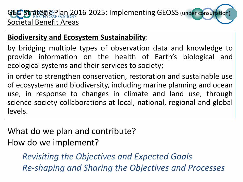
Biodiversity and Ecosystem Sustainability: by bridging multiple types of observation data and knowledge to provide information on the health of Earth’s biological and ecological systems and their services to society; in order to strengthen conservation, restoration and sustainable use of ecosystems and biodiversity, including marine planning and ocean use, in response to changes in climate and land use, through science-society collaborations at local, national, regional and global levels.
Concept to be shared? Common theme? Platform Obs sites? Databases? Actionable plan? Pilot / prototype activity? Communications? Players?
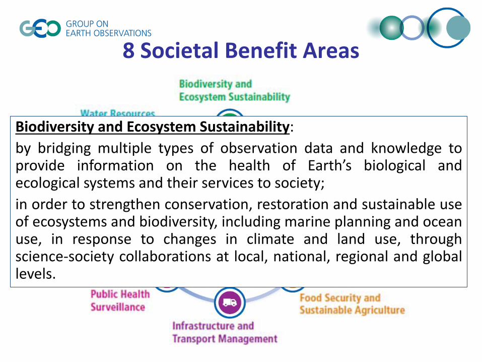
8 Societal Benefit Areas
Biodiversity and Ecosystem Sustainability: by bridging multiple types of observation data and knowledge to provide information on the health of Earth’s biological and ecological systems and their services to society; in order to strengthen conservation, restoration and sustainable use of ecosystems and biodiversity, including marine planning and ocean use, in response to changes in climate and land use, through science-society collaborations at local, national, regional and global levels.


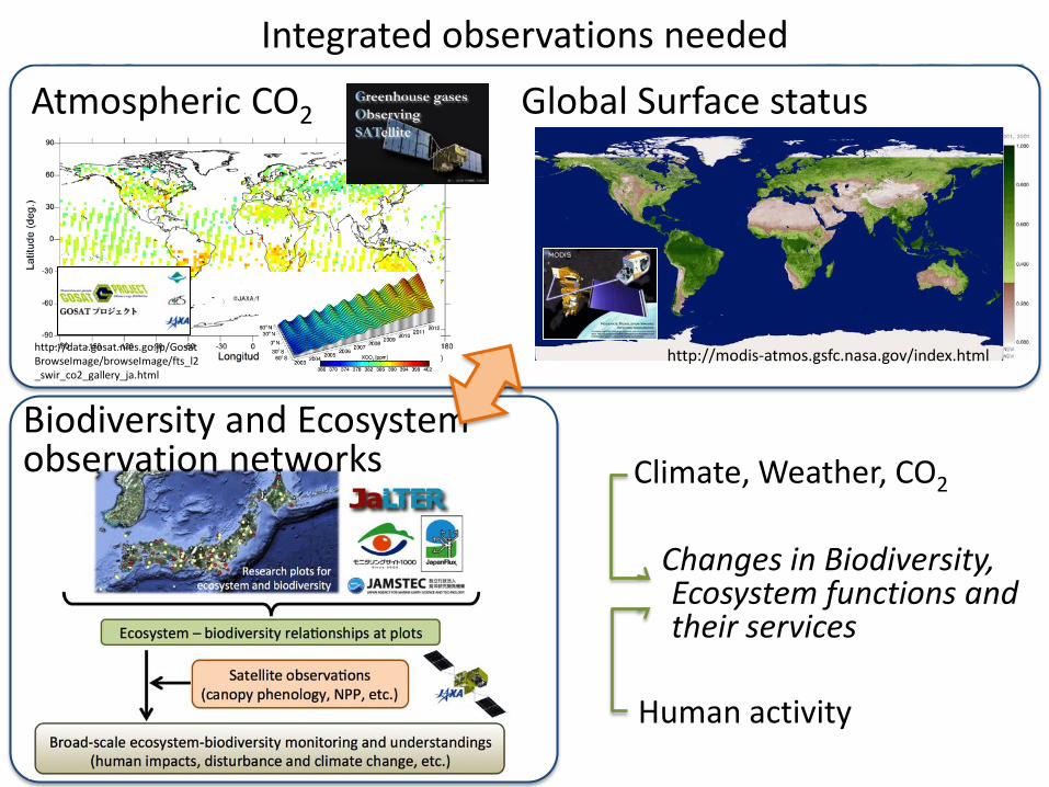
http://data.gosat.nies.go.jp/GosatBrowseImage/browseImage/fts_l2_swir_co2_gallery_ja.html
Atmospheric CO2
http://modis-atmos.gsfc.nasa.gov/index.html
Global Surface status
Changes in Biodiversity, Ecosystem functions and their services
Climate, Weather, CO2
Human activity
Integrated observations needed
Biodiversity and Ecosystem In-situ Observation networks
CARBON and WATER as the major common components of Atmosphere,
Ecosystems and Biodiversity
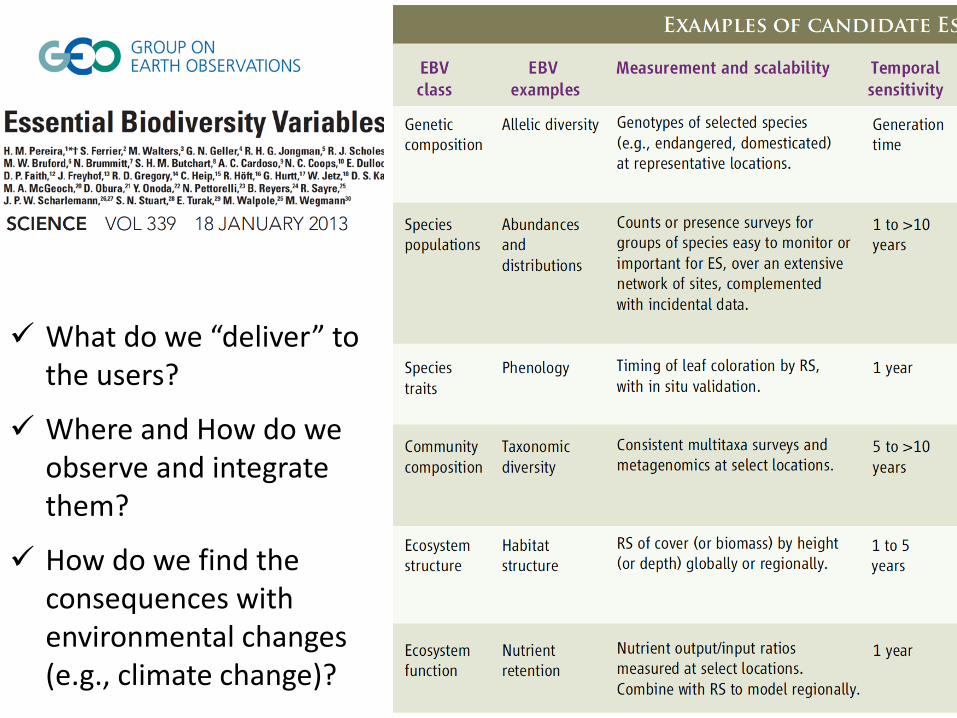
What do we “deliver” to the users?
Where and How do we observe and integrate them?
How do we find the consequences with environmental changes (e.g., climate change)?
http://data.gosat.nies.go.jp/GosatBrowseImage/browseImage/fts_l2_swir_co2_gallery_ja.html
Atmospheric CO2
http://modis-atmos.gsfc.nasa.gov/index.html
Global Surface status
Changes in Biodiversity, Ecosystem functions and their services
Climate, Weather, CO2
Human activity
Biodiversity and Ecosystem observation networks
Integrated observations needed
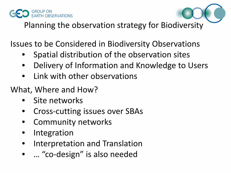
Issues to be Considered in Biodiversity Observations • Spatial distribution of the observation sites • Delivery of Information and Knowledge to Users • Link with other observations
What, Where and How? • Site networks • Cross-cutting issues over SBAs • Community networks • Integration • Interpretation and Translation • … “co-design” is also needed
Planning the observation strategy for Biodiversity
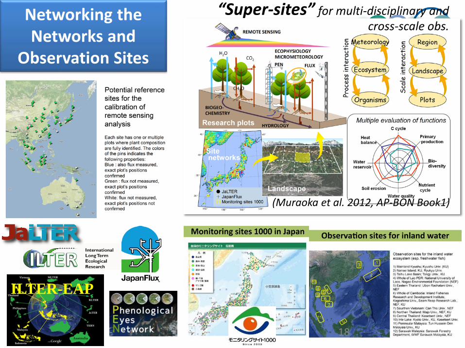
Networking the Networks and
Observation Sites
18
“Super-sites” for multi-disciplinary and cross-scale obs.
ILTER-EAP
(Muraoka et al. 2012, AP-BON Book1)
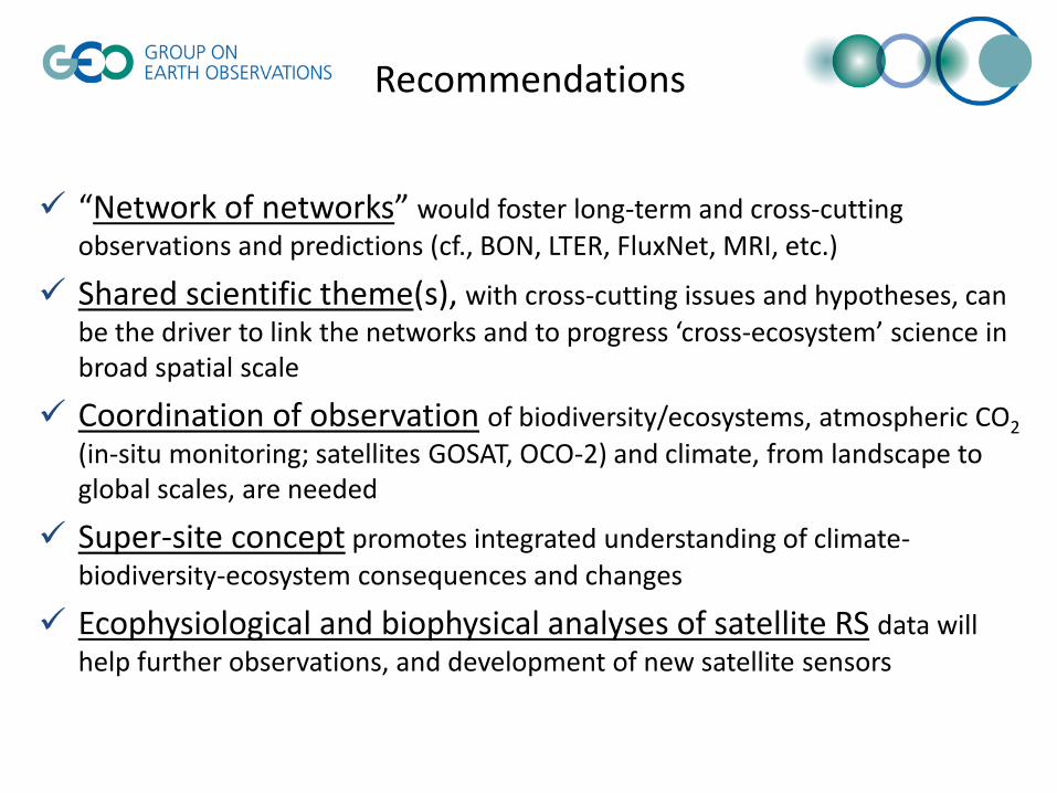
“Network of networks” would foster long-term and cross-cutting observations and predictions (cf., BON, LTER, FluxNet, MRI, etc.)
Shared scientific theme(s), with cross-cutting issues and hypotheses, can be the driver to link the networks and to progress ‘cross-ecosystem’ science in broad spatial scale
Coordination of observation of biodiversity/ecosystems, atmospheric CO2 (in-situ monitoring; satellites GOSAT, OCO-2) and climate, from landscape to global scales, are needed
Super-site concept promotes integrated understanding of climate-biodiversity-ecosystem consequences and changes
Ecophysiological and biophysical analyses of satellite RS data will help further observations, and development of new satellite sensors
Recommendations
Overview of GEO implementing Mechanisms
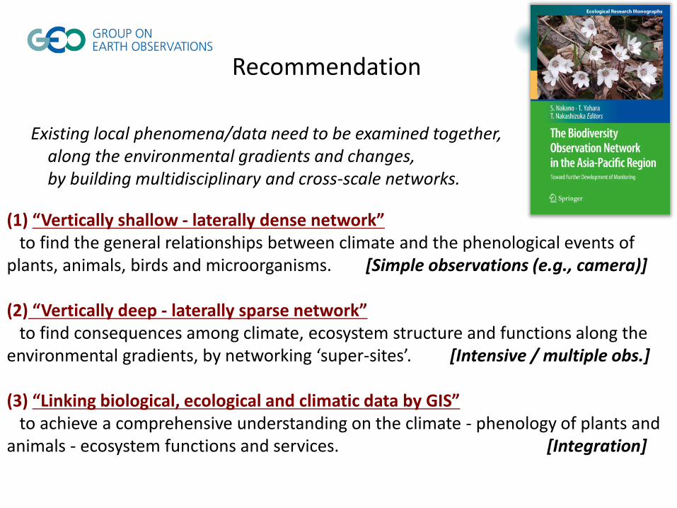
(1) “Vertically shallow - laterally dense network” to find the general relationships between climate and the phenological events of plants, animals, birds and microorganisms. [Simple observations (e.g., camera)] (2) “Vertically deep - laterally sparse network” to find consequences among climate, ecosystem structure and functions along the environmental gradients, by networking ‘super-sites’. [Intensive / multiple obs.] (3) “Linking biological, ecological and climatic data by GIS” to achieve a comprehensive understanding on the climate - phenology of plants and animals - ecosystem functions and services. [Integration]
Recommendation
Existing local phenomena/data need to be examined together, along the environmental gradients and changes, by building multidisciplinary and cross-scale networks.
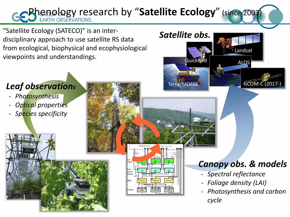
Phenology research by “Satellite Ecology” (since 2003)
Leaf observations - Photosynthesis - Optical properties - Species specificity
“Satellite Ecology (SATECO)” is an inter-disciplinary approach to use satellite RS data from ecological, biophysical and ecophysiological viewpoints and understandings.
Terra/MODIS
QuickBird
Landsat
ALOS
GCOM-C (2017-)
Canopy obs. & models - Spectral reflectance - Foliage density (LAI) - Photosynthesis and carbon
cycle
Satellite obs.

10m
250 - 1000m
Satellite remote sensing
In situ tower obs.
Ecophysiological studies
Ecosystem modeling Temporal scaling Spatial scaling Remote sensing
CO2 flux
Photosynthesis Optical property
Past Present Future minutes hours days seasons years
Earth
Region
Landscape
Plot
Multi-scale observation for phenology of photosynthesis
<< Linking ecophysiology and remote sensing >>
Muraoka et al. (2015) Ecol. Res.
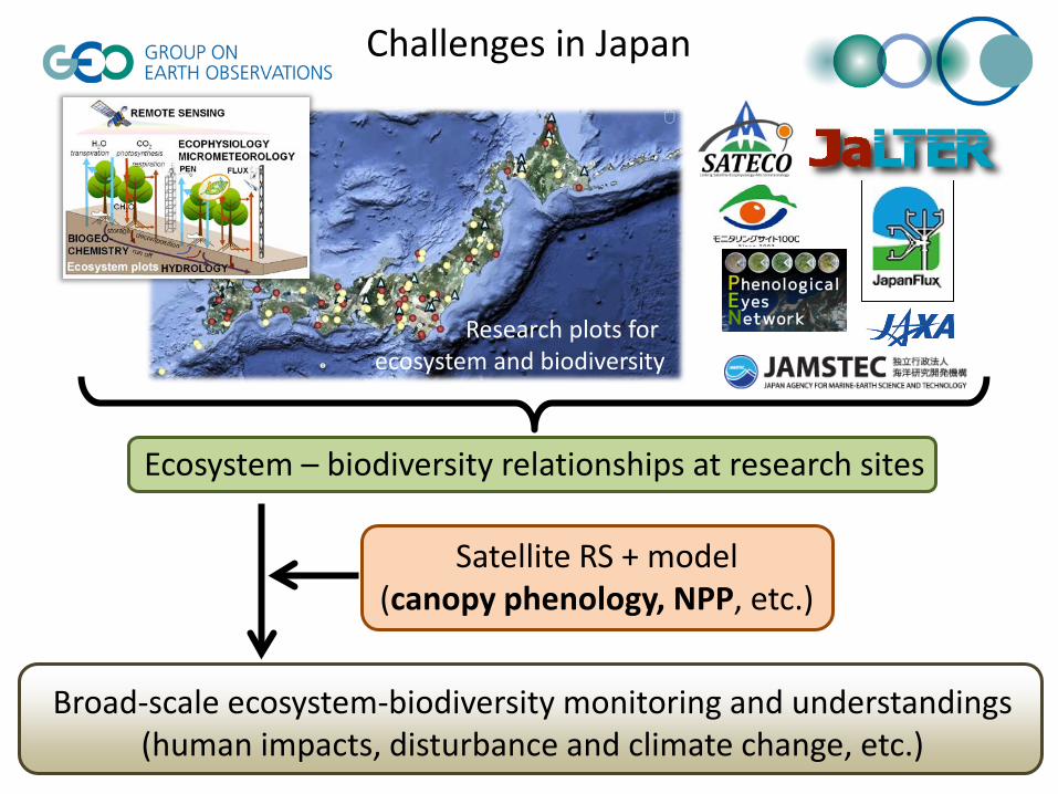
Challenges in Japan
Broad-scale ecosystem-biodiversity monitoring and understandings (human impacts, disturbance and climate change, etc.)
Ecosystem – biodiversity relationships at research sites
Satellite RS + model (canopy phenology, NPP, etc.)
Research plots for ecosystem and biodiversity
Biodiversity and Ecosystem Sustainability: by bridging multiple types of observation data and knowledge to provide information on the health of Earth’s biological and ecological systems and their services to society; in order to strengthen conservation, restoration and sustainable use of ecosystems and biodiversity, including marine planning and ocean use, in response to changes in climate and land use, through science-society collaborations at local, national, regional and global levels.
GEO Strategic Plan 2016-2025: Implementing GEOSS (under consultation)
Societal Benefit Areas
What do we plan and contribute? How do we implement?
Revisiting the Objectives and Expected Goals Re-shaping and Sharing the Objectives and Processes
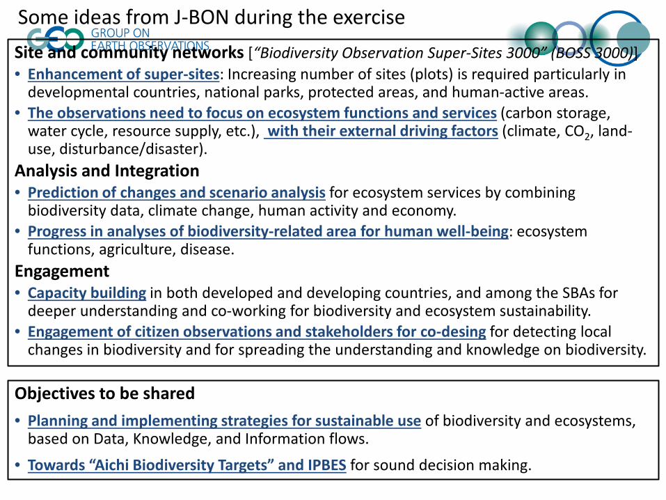
Site and community networks [“Biodiversity Observation Super-Sites 3000” (BOSS 3000)] • Enhancement of super-sites: Increasing number of sites (plots) is required particularly in
developmental countries, national parks, protected areas, and human-active areas. • The observations need to focus on ecosystem functions and services (carbon storage,
water cycle, resource supply, etc.), with their external driving factors (climate, CO2, land-use, disturbance/disaster).
Analysis and Integration • Prediction of changes and scenario analysis for ecosystem services by combining
biodiversity data, climate change, human activity and economy. • Progress in analyses of biodiversity-related area for human well-being: ecosystem
functions, agriculture, disease. Engagement • Capacity building in both developed and developing countries, and among the SBAs for
deeper understanding and co-working for biodiversity and ecosystem sustainability. • Engagement of citizen observations and stakeholders for co-desing for detecting local
changes in biodiversity and for spreading the understanding and knowledge on biodiversity.
Some ideas from J-BON during the exercise
Objectives to be shared • Planning and implementing strategies for sustainable use of biodiversity and ecosystems,
based on Data, Knowledge, and Information flows.
• Towards “Aichi Biodiversity Targets” and IPBES for sound decision making.
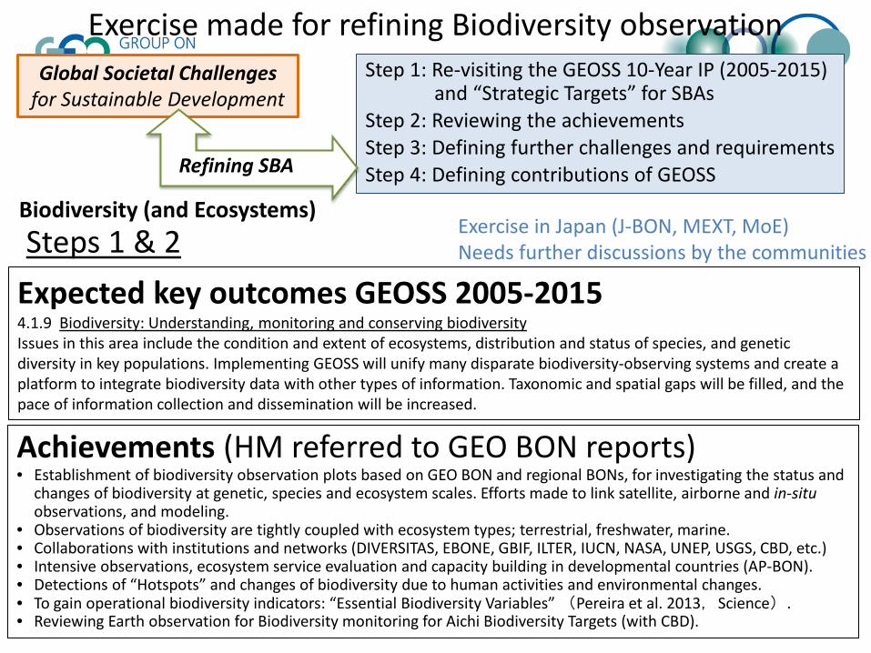
Achievements (HM referred to GEO BON reports) • Establishment of biodiversity observation plots based on GEO BON and regional BONs, for investigating the status and
changes of biodiversity at genetic, species and ecosystem scales. Efforts made to link satellite, airborne and in-situ observations, and modeling.
• Observations of biodiversity are tightly coupled with ecosystem types; terrestrial, freshwater, marine. • Collaborations with institutions and networks (DIVERSITAS, EBONE, GBIF, ILTER, IUCN, NASA, UNEP, USGS, CBD, etc.) • Intensive observations, ecosystem service evaluation and capacity building in developmental countries (AP-BON). • Detections of “Hotspots” and changes of biodiversity due to human activities and environmental changes. • To gain operational biodiversity indicators: “Essential Biodiversity Variables” (Pereira et al. 2013,Science). • Reviewing Earth observation for Biodiversity monitoring for Aichi Biodiversity Targets (with CBD).
Expected key outcomes GEOSS 2005-2015 4.1.9 Biodiversity: Understanding, monitoring and conserving biodiversity Issues in this area include the condition and extent of ecosystems, distribution and status of species, and genetic diversity in key populations. Implementing GEOSS will unify many disparate biodiversity-observing systems and create a platform to integrate biodiversity data with other types of information. Taxonomic and spatial gaps will be filled, and the pace of information collection and dissemination will be increased.
Exercise in Japan (J-BON, MEXT, MoE) Needs further discussions by the communities
Biodiversity (and Ecosystems) Steps 1 & 2
Exercise made for refining Biodiversity observation Step 1: Re-visiting the GEOSS 10-Year IP (2005-2015)
and “Strategic Targets” for SBAs Step 2: Reviewing the achievements Step 3: Defining further challenges and requirements Step 4: Defining contributions of GEOSS
Global Societal Challenges for Sustainable Development
Refining SBA

Challenges and opportunities for ecology communities
Ecology meets Earth Observations Multidisciplinary / Cross-scale Delivery of ecology to sustainable development Societal / User Needs Engagement of broad communities Networking / Interdisciplinary
Chapin et al. (2000)
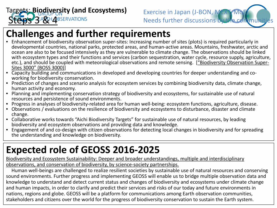
Targets: Biodiversity (and Ecosystems)
Challenges and further requirements • Enhancement of biodiversity observation super-sites: Increasing number of sites (plots) is required particularly in
developmental countries, national parks, protected areas, and human-active areas. Mountains, freshwater, arctic and ocean are also to be focused intensively as they are vulnerable to climate change. The observations should be linked with ecosystem types and their functions and services (carbon sequestration, water cycle, resource supply, agriculture, etc.), and should be coupled with meteorological observations and remote sensing. [“Biodiversity Observation Super-Sites 3000” (BOSS 3000)]
• Capacity building and communications in developed and developing countries for deeper understanding and co-working for biodiversity conservation.
• Prediction of changes and scenario analysis for ecosystem services by combining biodiversity data, climate change, human activity and economy.
• Planning and implementing conservation strategy of biodiversity and ecosystems, for sustainable use of natural resources and persistence of sound environments.
• Progress in analyses of biodiversity-related area for human well-being: ecosystem functions, agriculture, disease. • Observations / evaluations on the resilience of biodiversity and ecosystems to disturbance, disaster and climate
change. • Collaborative works towards “Aichi Biodiversity Targets” for sustainable use of natural resources, by leading
biodiversity and ecosystem observations and providing data and knowledge. • Engagement of and co-design with citizen observations for detecting local changes in biodiversity and for spreading
the understanding and knowledge on biodiversity.
Expected role of GEOSS 2016-2025 Biodiversity and Ecosystem Sustainability: Deeper and broader understandings, multiple and interdisciplinary observations, and conservation of biodiversity, by science-society partnerships. Human well-beings are challenged to realize resilient societies by sustainable use of natural resources and conserving sound environments. Further progress and implementing GEOSS will enable us to bridge multiple observation data and knowledge to understand and detect current status and changes of biodiversity and ecosystems under climate change and human impacts, in order to clarify and predict their services and risks of our today and future environments in nations, regions and globe. GEOSS will be a platform for communications among Earth observation communities, stakeholders and citizens over the world for the progress of biodiversity conservation to sustain the Earth system.
Steps 3 & 4 Exercise in Japan (J-BON, MEXT, MoE) Needs further discussions by the communities

Biodiversity and Ecosystem Sustainability
To secure our sustainable use and conservation of ecosystem resources and sound environments under climate change and human impacts at national, regional and global levels, by promoting deeper and broader understandings of biodiversity and ecosystems and their services, with enhanced science-society partnerships. The challenges promote our vision of “Living in harmony with nature”.
GEOSS bridges multiple observation data and knowledge, and be a platform for science-society collaborations, to understand and detect current status and changes of biodiversity and ecosystems under climate change and human impacts, in order to clarify and predict their services and risks of our today and future environments.
• Enhancement of biodiversity & ecosystem (+ climate) observation super-sites, particularly in developmental countries, national parks, protected areas, and human-active areas, and places vulnerable to climate change [Biodiversity Observation Super-Sites]. Land-use is of particular environmental changes.
• Supports in achieving “Aichi Biodiversity Targets” (CBD) by promoting integration of various data from satellite to citizen science. • Interdisciplinary understandings and evaluations on the resilience of biodiversity and ecosystems to disturbance, disaster and
climate change (Eco-DRR), under current and future environmental and societal conditions in nations, regions and Earth. • Prediction of changes and scenario analysis for ecosystem services by combining biodiversity data, climate change, human activity
and economy. (Contribution to IPBES) • Capacity building and communications in developed and developing countries for deeper understanding and co-working for
biodiversity conservation and sustainable use of natural resources.
(draft) (Note: still needs further discussions by the communities)
Shared targets
Key contributions of GEOSS
Global Challenges: Sustainable Development Goals Convention on Biological Diversity, ‘Aichi Biodiversity Targets’
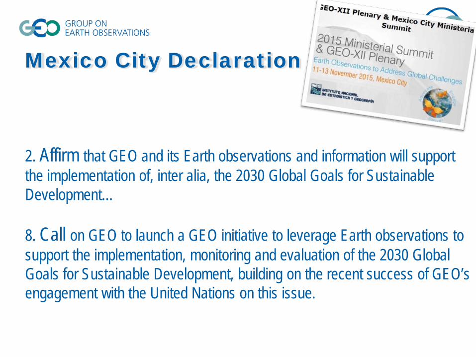
Mexico City Declaration
2. Affirm that GEO and its Earth observations and information will support the implementation of, inter alia, the 2030 Global Goals for Sustainable Development… 8. Call on GEO to launch a GEO initiative to leverage Earth observations to support the implementation, monitoring and evaluation of the 2030 Global Goals for Sustainable Development, building on the recent success of GEO’s engagement with the United Nations on this issue.
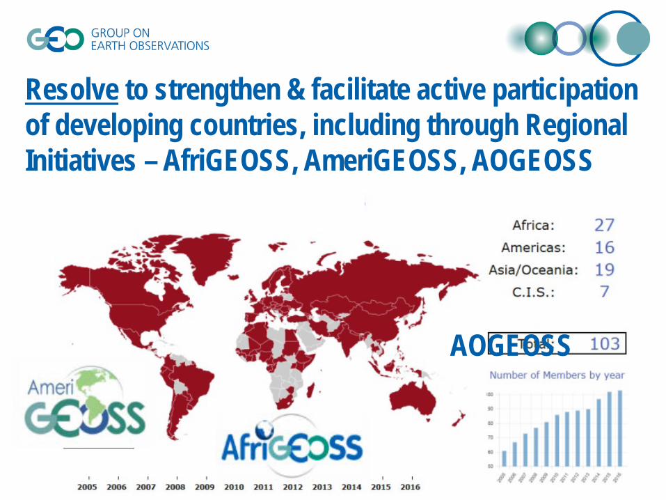
AOGEOSS
Resolve to strengthen & facilitate active participation of developing countries, including through Regional Initiatives – AfriGEOSS, AmeriGEOSS, AOGEOSS
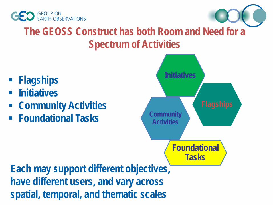
Flagships
Initiatives
CommunityActivities
Foundational Tasks
The GEOSS Construct has both Room and Need for a Spectrum of Activities
Flagships Initiatives Community Activities Foundational Tasks
Each may support different objectives, have different users, and vary across spatial, temporal, and thematic scales
GEO Flagship GEO Biodiversity Ob Global Forest Obser GEO Initiatives The GEO Global Eco GEO-GNOME Initiat Information in Mou GEO Carbon and GH Earth Observations Ocean and Society: Community Activiti Africa Global-scale environmental man Harmful Algal Bool For Gloval Mangrov In situ #####