CH05 Cumulative Impacts - SanDiegoCounty.gov evaluation of cumulative impacts associated with...
48
Gregory Canyon Landfill State Clearinghouse No. 1995061007 Final EIR Page 5-1 December 2002 Chapter 5.0 Cumulative Impacts Pursuant to Section 15355 of the State CEQA Guidelines, “ cumulative impacts” refers to two or more individual effects which, when considered together, are considerable or which compound or increase other environmental impacts. These individual effects may be changes resulting from a single project or a number of separate projects. The cumulative impact from several projects is the change in the environment which results from the incremental impact of the project when added to other closely related past, present and reasonably foreseeable probable future projects. Cumulative impacts can result from individually minor, but collectively significant projects taking place over a period of time. 5.1 PROJECTS EVALUATED FOR CUMULATIVE EFFECTS ANALYSIS This section examines cumulative impacts on a regional and local basis. For the purpose of this cumulative impact analysis, the following scenarios of potential cumulative effects were considered: 1. First, build-out of the County of San Diego as envisioned by the County’s General Plan, and more specifically, build-out of the surrounding areas based on adopted community plans and subregional plans (Fallbrook Community Plan, Pala/Pauma Subregional Plan and Valley Center Community Plan), were evaluated for consideration in the cumulative effects analysis. This level of evaluation was utilized to consider potential cumulative effects associated with land use, agricultural resources, aesthetics, socioeconomics, public services and utilities, and human health and safety. 2. Specific development projects which may not have been fully considered in community plans, subregional plans or general plan evaluations have also been considered (these are identified in Section 5.1.5). Information contained in the environmental documents for these projects was useful in determining potential cumulative effects associated with quantifiable impacts, such as traffic and circulation, noise and vibration, biological resources, cultural resources, and public services and utilities. 3. For cumulative effects associated with traffic circulation, the scenario was further expanded to include build-out of the region as anticipated in the San Diego Association of Governments’ (SANDAG) travel forecasts and the Regional Transportation Plan (RTP). 4. The cumulative air quality impacts analysis assumed build-out of the San Diego Air Basin as projected by SANDAG’s Regional Growth Management Plan. 5. An evaluation of cumulative impacts associated with geology and soils, hydrogeology, and surface hydrology was supplemented with review of existing map information, such as the San Diego Soils Series and Hydrologic Subunits and SANDAG publications (Watersheds of the San Diego Region, SANDAG INFO, March-April 1998). 6. Finally, this cumulative impacts analysis considers regional impacts associated with biological resources based on the County open space planning efforts for the Multiple Species Conservation Program (MSCP).
Transcript of CH05 Cumulative Impacts - SanDiegoCounty.gov evaluation of cumulative impacts associated with...
Gregory Canyon Landfill State Clearinghouse No. 1995061007 Final EIR Page 5-1 December 2002
Chapter 5.0 Cumulative Impacts
Pursuant to Section 15355 of the State CEQA Guidelines, “cumulative impacts” refers to two or more individual effects which, when considered together, are considerable or which compound or increase other environmental impacts. These individual effects may be changes resulting from a single project or a number of separate projects. The cumulative impact from several projects is the change in the environment which results from the incremental impact of the project when added to other closely related past, present and reasonably foreseeable probable future projects. Cumulative impacts can result from individually minor, but collectively significant projects taking place over a period of time.
5.1 PROJECTS EVALUATED FOR CUMULATIVE EFFECTS ANALYSIS This section examines cumulative impacts on a regional and local basis. For the purpose of this cumulative impact analysis, the following scenarios of potential cumulative effects were considered:
1. First, build-out of the County of San Diego as envisioned by the County’s General Plan, and more specifically, build-out of the surrounding areas based on adopted community plans and subregional plans (Fallbrook Community Plan, Pala/Pauma Subregional Plan and Valley Center Community Plan), were evaluated for consideration in the cumulative effects analysis. This level of evaluation was utilized to consider potential cumulative effects associated with land use, agricultural resources, aesthetics, socioeconomics, public services and utilities, and human health and safety.
2. Specific development projects which may not have been fully considered in community plans, subregional plans or general plan evaluations have also been considered (these are identified in Section 5.1.5). Information contained in the environmental documents for these projects was useful in determining potential cumulative effects associated with quantifiable impacts, such as traffic and circulation, noise and vibration, biological resources, cultural resources, and public services and utilities.
3. For cumulative effects associated with traffic circulation, the scenario was further expanded to include build-out of the region as anticipated in the San Diego Association of Governments’ (SANDAG) travel forecasts and the Regional Transportation Plan (RTP).
4. The cumulative air quality impacts analysis assumed build-out of the San Diego Air Basin as projected by SANDAG’s Regional Growth Management Plan.
5. An evaluation of cumulative impacts associated with geology and soils, hydrogeology, and surface hydrology was supplemented with review of existing map information, such as the San Diego Soils Series and Hydrologic Subunits and SANDAG publications (Watersheds of the San Diego Region, SANDAG INFO, March-April 1998).
6. Finally, this cumulative impacts analysis considers regional impacts associated with biological resources based on the County open space planning efforts for the Multiple Species Conservation Program (MSCP).
5.0 CUMULATIVE IMPACTS
Gregory Canyon Landfill State Clearinghouse No. 1995061007 Final EIR Page 5-2 December 2002
Provided below is a description of the planning documents and development projects which have been individually evaluated for their contribution to cumulative effects.
5.1.1 SAN DIEGO COUNTY GENERAL PLAN The County General Plan is broken into 12 countywide plan elements including: Open Space, Land Use, Circulation, Recreation, Seismic Safety, Scenic Highways, Public Safety, Noise, Housing, Conservation, Energy, and Public Services. The General Plan’s Regional Land Use Element is “. . . the primary base for guiding physical development of the unincorporated area of San Diego County.” According to the County of San Diego Regional Land Use Plan (Exhibit 4.1-2), areas to the north and south of the site are primarily designated Multiple Rural Use and Estate Lands. An area immediately north, which is the Fenton property, and properties west of the site are designated Agricultural Preserves. Immediately east of the site is the Pala Indian Reservation. The area along the San Luis Rey River is designated Impact Sensitive.
5.1.2 APPLICABLE SUBREGIONAL AND COMMUNITY PLANS According to the General Plan, land use categories delineated on the Regional Land Use Map are implemented through land use designations identified on community and subregional plan maps. For the Gregory Canyon project, build-out of the surrounding communities (Fallbrook, Pala/ Pauma and Valley Center), as envisioned by their respective adopted plans, is also relevant to the consideration of the project’s potential for cumulative effects. These plans are described below.
5.1.2.1 Pala/Pauma Community Plan
The majority of the project site is located within the Pala-Pauma Subregional Plan area, as shown in Exhibit 4.1-2. The Pala-Pauma Subregional Plan designates the project site as Public/Semi-Public Lands with a Solid Waste Facility (SWF) designator as mandated by Proposition C. Areas surrounding the project site include Indian Lands, Multiple Rural Use, Estate Lands, Agricultural Preserve, Impact Sensitive Use, and Intense Agricultural Use.
5.1.2.2 Fallbrook Community Plan
The western edge of the project site falls within the Fallbrook Community Plan area (see Exhibit 4.1-2). The Fallbrook Community Plan was originally adopted in December 31, 1974, and amended June 1, 1988. It includes goals, policies and recommendations for development of the community. The General Goal of the Fallbrook Community plan is, “. . . perpetuate the existing rural charm and village atmosphere while accommodating growth in such a manner that it will complement the environment of Fallbrook.”
5.1.2.3 Valley Center Community Plan
Valley Center borders the project site on the south and is characterized by unique topographic features, agricultural activities and prominence of estate residential development. The rural character of the community results from the low population density and the prevalence of large areas of open space provided by agricultural activities. An important goal of the Valley Center Community Plan is to, “. . . preserve and seek to enhance the rural character of Valley Center by maintaining a pattern of land use consistent with . . .” the land use categories established by the County’s Regional Land Use Element: Country Town, Estate Development Area, and Rural Development Area.
5.0 CUMULATIVE IMPACTS
Gregory Canyon Landfill State Clearinghouse No. 1995061007 Final EIR Page 5-3 December 2002
5.1.3 SANDAG REGIONAL PLANNING ELEMENTS
5.1.3.1 Regional Growth Management Strategy
The Regional Growth Management Strategy contains standards, objectives and recommended actions for factors related to the quality of life in the San Diego region. These factors include: air quality, transportation/congestion management, water, sewage disposal, sensitive lands and open space preservation and protection, solid waste management, hazardous waste management, housing, and economic prosperity. The Regional Growth Management Strategy provides a framework for managing growth in the region.
5.1.3.2 Series 8 Population Forecasts
Series 8 Population Forecasts provide the basis for determining cumulative impacts relative to population-driven issue areas, such as traffic, public facilities and utilities, etc. The County has an estimated present population of about 2,690,255. By the year 2015, the County is expected to have a population of 3,763,253. The County is broken into Major Statistical Areas (MSA), and the project site falls within MSA 5 (North County East). The estimated population for the North County East MSA in 1990 was estimated at 312,477 and is projected to increase to 400,309 by the year 2000.
Available census data for the project area indicates that the Pala-Pauma Community Plan area is estimated to have a total population of 5,221, as of January 1997. Fallbrook has an estimated population of 36,112; and the adjacent community of Valley Center has an estimated population of 14,759. The Series 8 Regional Growth Forecast for these areas indicates that the Pala-Pauma Community Plan area is anticipated to grow to a population of 20,971, by the year 2015. Fallbrook is projected to have 58,807 people, while the population projection for Valley Center is 28,169.
5.1.3.3 Regional Transportation Plan
Cumulative effects relative to traffic impacts are based on build-out assumptions developed by SANDAG as part of the RTP. The RTP is a set of policies, plans and programs to guide effective coordination and orderly programming of transportation improvements among local, regional, state and federal agencies. Developed through a continuing, comprehensive and cooperative planning process, the RTP addresses major transportation issues and contains goals, objectives, policies and specific actions. The RTP policies encompass travel by automobiles, trucks, buses, bicycles, trolleys, rail cars, airplanes, and pedestrians. Based on a variety of projections, including traffic and population growth, the RTP is able to identify the facilities, services, and programs necessary to help meet the increasing travel needs of the region through the year 2020. The RTP relies on Regional Growth Forecasts and Regional Transportation Forecasts to develop a system of roads and highways which meets anticipated future travel demand. For the most part, build-out of the County’s General Plan and various community and subregional plans have been assumed in the travel forecasts for the RTP.
5.1.4 COUNTY-WIDE OPEN SPACE AND RESOURCE MAPPING For an evaluation of cumulative impacts associated with biological resources and wildlife habitat, information obtained from SANDAG provides a regional perspective to remaining habitats throughout the County. The population, housing and employment growth of the 1980s
5.0 CUMULATIVE IMPACTS
Gregory Canyon Landfill State Clearinghouse No. 1995061007 Final EIR Page 5-4 December 2002
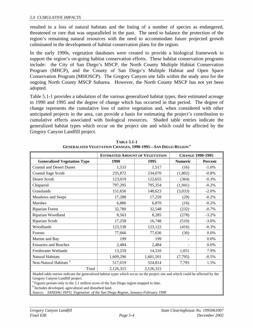
resulted in a loss of natural habitats and the listing of a number of species as endangered, threatened or rare that was unparalleled in the past. The need to balance the protection of the region’s remaining natural resources with the need to accommodate future projected growth culminated in the development of habitat conservation plans for the region.
In the early 1990s, vegetation databases were created to provide a biological framework to support the region’s on-going habitat conservation efforts. These habitat conservation programs include: the City of San Diego’s MSCP, the North County Multiple Habitat Conservation Program (MHCP), and the County of San Diego’s Multiple Habitat and Open Space Conservation Program (MHOSCP). The Gregory Canyon site falls within the study area for the ongoing North County MSCP Subarea. However, the North County MSCP has not yet been adopted.
Table 5.1-1 provides a tabulation of the various generalized habitat types, their estimated acreage in 1990 and 1995 and the degree of change which has occurred in that period. The degree of change represents the cumulative loss of native vegetation and, when considered with other anticipated projects in the area, can provide a basis for estimating the project’s contribution to cumulative effects associated with biological resources. Shaded table entries indicate the generalized habitat types which occur on the project site and which could be affected by the Gregory Canyon Landfill project.
TABLE 5.1-1 GENERALIZED VEGETATION CHANGES, 1990-1995—SAN DIEGO REGION a
ESTIMATED AMOUNT OF VEGETATION CHANGE 1990-1995 Generalized Vegetation Type 1990 1995 Numeric Percent
Coastal and Desert Dunes 1,533 1,517 (16) -1.0% Coastal Sage Scrub 235,872 234,070 (1,802) -0.8% Desert Scrub 123,019 122,655 (364) -0.3% Chaparral 797,295 795,354 (1,941) -0.2% Grasslands 151,656 148,623 (3,033) -2.0% Meadows and Seeps 17,288 17,259 (29) -0.2% Marshes 6,886 6,870 (16) -0.2% Riparian Forest 32,780 32,548 (232) -0.7% Riparian Woodland 8,563 8,285 (278) -3.2% Riparian Scrub 17,258 16,748 (510) -3.0% Woodlands 123,538 123,122 (416) -0.3% Forests 77,666 77,636 (30) 0.0% Marine and Bay 199 199 - 0.0% Estuaries and Beaches 2,484 2,484 - 0.0% Freshwater Wetlands 13,259 14,310 1,051 7.9% Natural Habitats 1,609,296 1,601,501 (7,795) -0.5% Non-Natural Habitats b 517,019 524,814 7,795 1.5%
Total 2,126,315 2,126,315 Shaded table entries indicate the generalized habitat types which occur on the project site and which could be affected by the Gregory Canyon Landfill project. a Figures pertain only to the 2.1 million acres of the San Diego region mapped to date. b Includes developed, agricultural and disturbed land. Source: SANDAG INFO, Vegetation of the San Diego Region, January-February 1998
5.0 CUMULATIVE IMPACTS
Gregory Canyon Landfill State Clearinghouse No. 1995061007 Final EIR Page 5-5 December 2002
In addition to the region’s on-going vegetation mapping and habitat planning efforts, impacts to coastal sage scrub habitat are regulated through a special rule under Section 4(d) of the Federal Endangered Species Act, until a conservation plan is approved for many unincorporated areas of the County. The special rule authorizes incidental take of the coastal California gnatcatcher in conjunction with an approved plan under the California Natural Communities Conservation Plan (NCCP) established by the governor in 1991. The NCCP guidelines indicate that a five percent loss of coastal sage scrub within any individual subregion is acceptable during the preparation of a subregional plan.
SPECIFIC PROJECTS EVALUATED AS PART OF THE CUMULATIVE EFFECTS ANALYSIS In addition to the general level of analysis afforded by review of cumulative impacts at the regional level, an analysis at the local level also was conducted. To assess the potential cumulative impacts of the proposed project in concert with other projects in the study area, a detailed inventory of recently approved and potential future projects was conducted. This list was prepared based on consultation with San Diego County staff and a review of other environmental and planning documents for projects in the vicinity of the Gregory Canyon site.
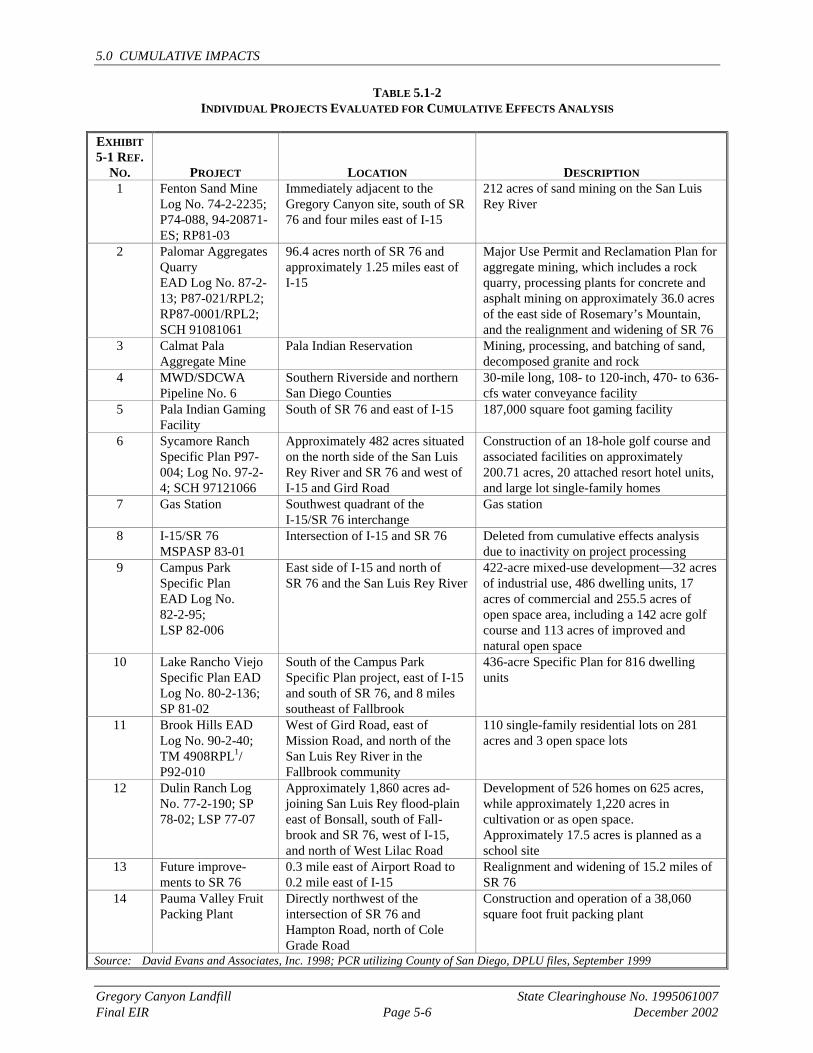
Table 5.1-2 provides a summary of each project’s location and general description, and Exhibit 5.1-1 shows the location of these projects in relationship to the project site. The description of each project identifies the areas that each project contributes to the cumulative impacts analysis.
Environmental documents prepared for these projects are on file with the County of San Diego and can be reviewed at the San Diego County Department of Planning and Land Use, 5201 Ruffin Road, Suite B, San Diego, CA 92123.
5.1.5.1 H.G. Fenton Company Pala Site Sand Mine (EAD Log No. 74-2-2235; P74-088, 94-20871-ES; RP81-03)
The H.G. Fenton Company Pala Site Sand Mine is located on approximate 212 acres along the San Luis Rey River about four miles east of Interstate 15 (I15) on State Route 76 (SR 76). The mine operates under a Major Use Permit (74-088) from the County of San Diego. The mine is currently not operating at its full capacity.
As a result of a 1992 Compliance Order issued by the U.S. Environmental Protection Agency (EPA), the mine owner/operator began construction of a 4,900-foot long by 80-foot wide dike to confine the San Luis Rey River to the eastern portion of the property to facilitate compliance with permitting conditions and to allow for issuance of the required Section 404 and Section 401 permits.
During construction of the dike, two arroyo toads were found and EPA mandated that the owner/operator cease work on the project. The owner/operator is expected to submit a modification of the Major Use Permit to San Diego County. The modification would relocate various portions of the operation and set aside portions of the site for mitigation. No change to the volume of excavated material or footprint are expected.
5.0 CUMULATIVE IMPACTS
Gregory Canyon Landfill State Clearinghouse No. 1995061007 Final EIR Page 5-6 December 2002
TABLE 5.1-2 INDIVIDUAL PROJECTS EVALUATED FOR CUMULATIVE EFFECTS ANALYSIS
EXHIBIT 5-1 REF.
NO. PROJECT LOCATION DESCRIPTION 1 Fenton Sand Mine
Log No. 74-2-2235; P74-088, 94-20871-ES; RP81-03
Immediately adjacent to the Gregory Canyon site, south of SR 76 and four miles east of I-15
212 acres of sand mining on the San Luis Rey River
2 Palomar Aggregates Quarry EAD Log No. 87-2-13; P87-021/RPL2; RP87-0001/RPL2; SCH 91081061
96.4 acres north of SR 76 and approximately 1.25 miles east of I-15
Major Use Permit and Reclamation Plan for aggregate mining, which includes a rock quarry, processing plants for concrete and asphalt mining on approximately 36.0 acres of the east side of Rosemary’s Mountain, and the realignment and widening of SR 76
3 Calmat Pala Aggregate Mine
Pala Indian Reservation Mining, processing, and batching of sand, decomposed granite and rock
4 MWD/SDCWA Pipeline No. 6
Southern Riverside and northern San Diego Counties
30-mile long, 108- to 120-inch, 470- to 636-cfs water conveyance facility
5 Pala Indian Gaming Facility
South of SR 76 and east of I-15 187,000 square foot gaming facility
6 Sycamore Ranch Specific Plan P97-004; Log No. 97-2-4; SCH 97121066
Approximately 482 acres situated on the north side of the San Luis Rey River and SR 76 and west of I-15 and Gird Road
Construction of an 18-hole golf course and associated facilities on approximately 200.71 acres, 20 attached resort hotel units, and large lot single-family homes
7 Gas Station Southwest quadrant of the I-15/SR 76 interchange
Gas station
8 I-15/SR 76 MSPASP 83-01
Intersection of I-15 and SR 76 Deleted from cumulative effects analysis due to inactivity on project processing
9 Campus Park Specific Plan EAD Log No. 82-2-95; LSP 82-006
East side of I-15 and north of SR 76 and the San Luis Rey River
422-acre mixed-use development—32 acres of industrial use, 486 dwelling units, 17 acres of commercial and 255.5 acres of open space area, including a 142 acre golf course and 113 acres of improved and natural open space
10 Lake Rancho Viejo Specific Plan EAD Log No. 80-2-136; SP 81-02
South of the Campus Park Specific Plan project, east of I-15 and south of SR 76, and 8 miles southeast of Fallbrook
436-acre Specific Plan for 816 dwelling units
11 Brook Hills EAD Log No. 90-2-40; TM 4908RPL1/ P92-010
West of Gird Road, east of Mission Road, and north of the San Luis Rey River in the Fallbrook community
110 single-family residential lots on 281 acres and 3 open space lots
12 Dulin Ranch Log No. 77-2-190; SP 78-02; LSP 77-07
Approximately 1,860 acres ad-joining San Luis Rey flood-plain east of Bonsall, south of Fall-brook and SR 76, west of I-15, and north of West Lilac Road
Development of 526 homes on 625 acres, while approximately 1,220 acres in cultivation or as open space. Approximately 17.5 acres is planned as a school site
13 Future improve-ments to SR 76
0.3 mile east of Airport Road to 0.2 mile east of I-15
Realignment and widening of 15.2 miles of SR 76
14 Pauma Valley Fruit Packing Plant
Directly northwest of the intersection of SR 76 and Hampton Road, north of Cole Grade Road
Construction and operation of a 38,060 square foot fruit packing plant
Source: David Evans and Associates, Inc. 1998; PCR utilizing County of San Diego, DPLU files, September 1999
��
��
��
��
�������������������� ���� ���� ��
����������� ������� ���� ����������������������������� �!" �� �!#����� ����$��������
�
���������
�� % �&
�'
(
�)
*
� '
&
+
,
�,
�
�-.�/�0��������� ��'-� 1�� �#����� ��2��34� ���&-� 1� �5� 1 #����� ������,-�6�7���6#����1���8��9��%+-� 1 $�!� �/ ����0 ��1���%-��� ����2 ��������:���1 �(-/ ��� ����*-$5�+7�2(%� ���������:���1 �#�� ;�-� ����� �3�����:���1 ��)-� 3�2 ����<��=������:���1 ���-����3.�11��'-��1��2 ����&-0�����$���� ���������25(%�,-� �� < 11��0����� �3����1 ��
���������������������������������������������������������� �������������!
� " �#
5.0 CUMULATIVE IMPACTS
Gregory Canyon Landfill State Clearinghouse No. 1995061007 Final EIR Page 5-8 December 2002
This project is considered in the cumulative effects analysis for the following issue areas: land use, geology and soils, hydrogeology, surface hydrology, traffic and circulation, noise, air quality/health risk, agricultural resources, biological resources, aesthetics, socioeconomics, human health and safety, and cultural resources.
5.1.5.2 Palomar Aggregate Rock Quarry (EAD Log No. 87-2-13; P87-021/RPL2; RP87-0001/RPL2; SCH No. 91081061)
On March 5, 1997, San Diego County certified an EIR and approved a Major Use Permit (87-021) for the Palomar Aggregates Rock Quarry project, which is located on the north side of SR 76 about 1.25 miles east of I-15. Palomar Aggregate Rock Quarry was the subject of a court case, Riverwatch v. County of San Diego (1999, 76 Cal.App. 4th 1428). The court’s decision was published December 23, 1999. The quarry project is now being reviewed, and information is being processed by the County. The project involves the development of a rock quarry and processing plant for concrete and asphalt on 36 acres of an approximately 96-acre parcel. Mining would occur primarily on the east-facing slopes of Rosemary's Mountain, over a period of about 20 years. An estimated 22 million tons of rock would be mined.
In addition to the proposed mining and processing operations, the project includes the realignment and widening of SR 76 from the quarry project site west to I-15. This realignment eliminates short radius curves west of the project site. The roadway would be widened from two lanes to four lanes between I-15 and the western boundary of the quarry project site. The SR 76 roadway would then transition from four lanes to three lanes at the western boundary of the quarry project site and then back to two lanes just east of the site. The project also includes a reclamation plan which would prepare the lower portion of the site for use as a water storage reservoir at the completion of all mining activities.
This project is considered in the cumulative effects analysis for the following issue areas: land use, geology and soils, hydrogeology, surface hydrology, traffic and circulation, noise, air quality/health risk, agricultural resources, biological resources, aesthetics, socioeconomics, human health and safety, and cultural resources.
5.1.5.3 Calmat-Pala Aggregate Mine
This project is located on the Pala Indian Reservation and includes mining, processing and batching of sand, decomposed granite and rock. Because it is located on an Indian Reservation, it is not subject to local land use or local or state environmental regulations. This project is considered in the cumulative effects analysis for the following issue areas: land use, geology and soils, hydrogeology, surface hydrology, traffic and circulation, noise, air quality/health risk, agricultural resources, biological resources, aesthetics, socioeconomics, human health and safety, and cultural resources.
5.1.5.4 Metropolitan Water District/San Diego County Water Authority Pipeline No. 6
The San Diego Pipeline No. 6, which is a joint Metropolitan Water District (MWD)/San Diego County Water Authority (SDCWA) project, will consist of a 9- to 10-foot diameter pipeline (150-foot wide easement) originating at Lake Skinner in southern Riverside County, and extending south to an existing diversion structure in the Twin Oaks Valley area of northern San Diego County. This discussion is based on information from the 1993 certified Final EIR for Pipeline No. 6 (incorporated by reference) and conversations with the water agencies. A greater
5.0 CUMULATIVE IMPACTS
Gregory Canyon Landfill State Clearinghouse No. 1995061007 Final EIR Page 5-9 December 2002
level of detail for Pipeline No. 6 is provided in the Gregory Canyon Landfill cumulative analysis compared with other cumulative projects because the pipeline will cross north-south through the project site and construction staging areas will be located on the site.
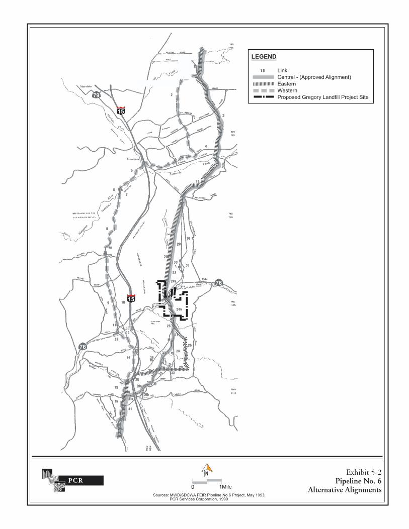
Exhibit 5-2 shows the alternative alignments for Pipeline No. 6. The approved alternative for the pipeline is the central alignment (central subalternative C2), with the eastern alignment rated second, based on system practicability, operations effectiveness and environmental/sociological impacts.
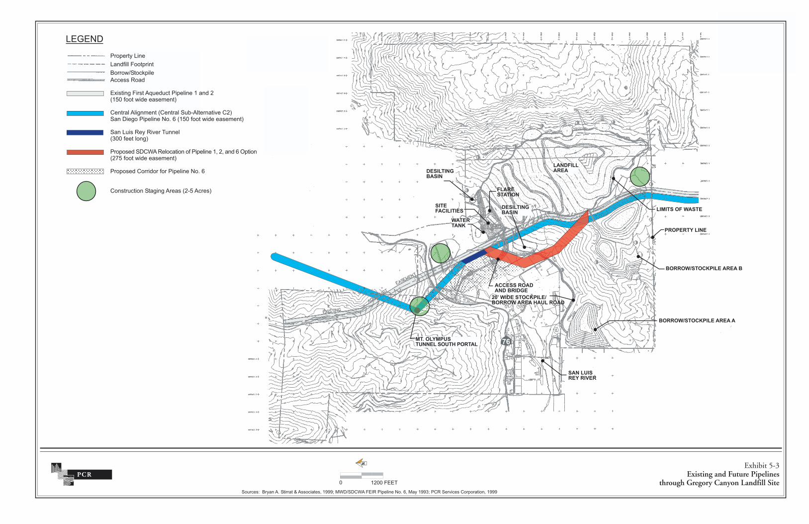
Exhibit 5-3 shows the alignment through the Gregory Canyon Landfill site. The exhibit also shows a corridor west of the preferred alignment that might be used if the alignment for the pipeline were to be moved to the west. The cumulative discussion considers the corridor as well as the preferred alignment. Construction of Pipeline No. 6 could begin in year 2003 and will be ongoing for about five years on the Gregory Canyon site. The southern portal (e.g., access to southern end of tunnel) of the proposed 6.5-mile Mt. Olympus Tunnel will be constructed by MWD, north of SR 76 on the Gregory Canyon Landfill site (Exhibit 5-3). In addition, a two- to five-acre construction staging area will be located directly adjacent to the Mt. Olympus Tunnel south portal. A 300-foot long tunnel will be constructed under the San Luis Rey River by SDCWA.
A two- to five-acre construction staging area will be located immediately north of the river east of the existing SDCWA First Aqueduct (Exhibit 5-3). A third staging area, also two- to five-acres in size, for trench cut-and-cover construction, will be located on the southern portion of the project site just west of the landfill footprint.
Mt. Olympus Tunnel Construction
Portals on either end of the 6.5-mile Mt. Olympus Tunnel would be required to allow ingress and egress to the tunnel both during construction and operation. The tunnel would be excavated with modern tunnel boring machines powered by electrical and hydraulic systems and/or with controlled underground drill and blast methods most likely from the southern to northern portal. The majority of the underground tunnel construction would be neither visible nor audible from the surface except locally at the access portals on either end of the tunnel. Construction would occur seven days a week, 24-hours a day. Following excavation of the tunnels, the tunnels would be lined with concrete or steel.
Most of the surface activities associated with tunnel construction would occur at the south portal including temporary construction laydown areas and shop space. The other portal would be required to provide a stabilized opening for egress of the tunneling excavation equipment after completion of the tunnel excavation.
The portals will be excavated using conventional earth moving and rock cutting equipment such as dozers, scrapers, backhoes, or clam shells. In hard rock areas, controlled blasting will be required. Depending on the ground conditions, the tunnel portal excavations may be sloped and unsupported or steeper cut slopes may require temporary support such as rock bolts, shotcrete, wire mesh, sheet piling or soldier piles and lagging.
Total excavated muck/spoil for the Mt. Olympus Tunnel is estimated at 252,000 cubic yards. Tunnel excavation muck/spoil is normally dumped as uncompacted canyon fill or as slope fill
��
��
��
��
��
�
���������� ������������������������������ !""#$������%����������������!"""
���������������������
�� ���� ������������ �& !���
����
'��(�������)*�����%�+���,�-���.���������������������+/��,�� '��+0��������������
������������� �������������������������������������
���������������� ��������������� � !�"#������� ������$���%
&�����������$����!&���������'(��������)��& %����*�����������+�,�-�!�"#������� ������$���%
������������)���.�����!/##����������%
������� ��*&0�����������������������1� 1��� �-�2����! 3"������� ������$���%
������� �&��� ��������������+�,�-
&������������������������! ("������%
�4�+*
�������������
�� ������������ ���
� ��� �������
�� ������������ ��
������� ��� ���
�������������
�� �������
�������������
�������������
������� �
��
�� ���
������ ������ ����
�������������������� �� ������ ��
�������������������������� ��
������������������������ �����������
�� ������ ��� ��������������������������5���������,��������6����������1��7778�90*��*&0����:���������+�,�-1�9����77/8��&�����)����&���������1��777
�
# � ##����.
5.0 CUMULATIVE IMPACTS
Gregory Canyon Landfill State Clearinghouse No. 1995061007 Final EIR Page 5-12 December 2002
This Page Intentionally Left Blank
5.0 CUMULATIVE IMPACTS
Gregory Canyon Landfill State Clearinghouse No. 1995061007 Final EIR Page 5-13 December 2002
near the portal. The selected site for disposal is located in a small drainage approximately 1,500 feet northwest of the south portal. Consideration was given to haul distance from the portal, visibility and drainage area. Materials may be transported on SR 76 to the east of the Gregory Canyon site.
San Luis Rey River Tunnel Construction
Specialized tunneling methods may be utilized because of the presence of a high groundwater table and the desire to minimize disturbance to the riparian zone in and adjacent to the river channel. It is anticipated that the majority of the tunnel would be excavated with either hand tools or a mechanical digger powered by electrical or diesel and hydraulic systems. Methods such as earth pressure balance tunneling, slurry grouting, and freezing will be investigated during design to determine their applicability. Following excavation of the tunnel, the tunnel would be lined with concrete or steel. The majority of the underground tunnel construction would be neither visible nor audible from the surface except at either end of the tunnel. Total excavated spoil for the San Luis Rey River Tunnel is estimated at 2,200 cubic yards.
General Pipeline Trench Cut-and-Cover Construction
Trenching operations would depend on the trench type and construction operations selected by the contractor. The type of trench excavation would depend on space available, in-situ soil properties, groundwater level, and allowable cut slope. In addition, factors such as surface water diversion and control requirements, and equipment and materials storage, will dictate the amount of work area needed for pipeline construction. In unrestricted working areas, between 200 and 400 feet per day of pipe could be installed. In restricted working areas, 50 to 100 feet per day of pipe could be installed. The construction zone would normally vary in width up to 150 feet and in length up to 2,000 feet. Pipe placement, joint welding and other construction practices would require this length of pipeline to remain open for several weeks.
Where necessary, a trench shield or soldier piles and timber lagging could be used. Soldier piles could be driven in advance of the pipe heading and the lagging could be installed as the trench excavation progresses. Some of the pipeline trenching may be located in hard rock areas where blasting is required. Blasting operations normally precede trenching excavation activities and would be completed in a relatively short time period.
Access Roads and Traffic
Vehicular access to the pipeline right-of-way would be required both for construction and for patrol and maintenance activities. Vehicle traffic associated with pipeline construction consists of construction equipment, work force transportation, material deliveries and spoil removal. Access roads will be used by an average of 20 to 40 people, using their own vehicles. The primary material that would be delivered to the construction zone is pipe, generally delivered in 40-foot long sections. Based on an average pipe-laying rate of 200 to 400 feet per day, approximately 5 to 10 deliveries per day are assumed. Muck/spoil material that is unusable on site for backfill, or which cannot be stored onsite due to area restrictions, would be removed from the site.
Construction crews would utilize public roads to the greatest extent feasible for access to staging areas and construction zones. Temporary or permanent access easements would be obtained along private roads, as necessary. In all but very steep terrain, the graded pipeline right-of-way would be available for use as construction access where use of existing public and private roads
5.0 CUMULATIVE IMPACTS
Gregory Canyon Landfill State Clearinghouse No. 1995061007 Final EIR Page 5-14 December 2002
is not a practical option. In some cases, additional roads may need to be graded where use of immediately adjacent existing public and private roads is not practical or the pipeline right-of-way is too steep to use.
Access road plans would be developed during the design phase of the project. Following completion of the pipeline construction, permanent access roads will be retained for purposes of patrol, maintenance and repair. Roads will not be maintained at crossings of the San Luis Rey River or in areas of extreme slope. Patrol roads would consist of public roads, pipeline right-of-way, private roads or new roads. Patrol roads along pipeline right-of-way would be 15 to 20 feet wide.
This project is considered in the cumulative effects analysis for the following issue areas: land use, geology and soils, hydrogeology, surface hydrology, traffic and circulation, noise, air quality/health risk, agricultural resources, biological resources, paleontological resources, ethnohistory/cultural resources, aesthetics, socioeconomics, public services and utilities, and human health and safety.
5.1.5.5 Pala Gaming Facility
The Pala Band of Mission Indians is proposing to construct a gaming facility on reservation land on the north side of SR 76, east of the project site in the vicinity of the Pala community. The proposed gaming facility will be subject to the recently negotiated compact between the Pala Band of Mission Indians and the State, which provides for environmental review of impacts from development on reservation land. The facility, which is currently under construction, will consist of approximately 187,000 square feet. The facility will include a casino, restaurants, entertainment, administration, and support services. The facility is located on a 24-acre site to the east of the project site on the south side of SR 76 (Exhibit 5-1). The Draft Environmental Assessment (EA) for the Pala Gaming Facility was circulated for public review in April 2000. The Draft EA analyzes the potential impacts from the facility. This project is considered in the cumulative effects analysis for the following issue areas: land use, geology and soils, hydrogeology, surface hydrology, traffic and circulation, noise, air quality/health risk, socioeconomics, biological resources, and cultural resources.
5.1.5.6 Sycamore Ranch Specific Plan (P97-004, Log No. 97-2-4, SCH No. 9712066
The Sycamore Ranch Specific Plan is located on 482 acres west of I-15, Gird Road, and north of SR 76. The Specific Plan allows for the development of 486 residential lots and a golf course. An application has been submitted to the County and is under review for a Major Use Permit for the golf course. The Major Use Permit results in a reconfiguration of lots and an overall reduction of lots to 195.
This project is considered in the cumulative effects analysis for the following issue areas: land use, geology and soils, hydrogeology, surface hydrology, traffic and circulation, noise, air quality/health risk, agricultural resources, biological resources, paleontological resources, ethnohistory/cultural resources, aesthetics, public services and utilities, socioeconomics, and human health and safety.
5.1.5.7 Gas Station
A gas station is proposed in the southwest quadrant of the I-15/SR 76 interchange. This area is a graded pad generally devoid of native vegetation. The site is periodically used for parking trucks
5.0 CUMULATIVE IMPACTS
Gregory Canyon Landfill State Clearinghouse No. 1995061007 Final EIR Page 5-15 December 2002
and other vehicles in transport. This project is considered in the cumulative effects analysis for land use, traffic and circulation, air quality/health risk, biological resources, and human health and safety.
5.1.5.8 I-15/SR 76 Master Specific Plan Area (MSPA) (SP 83-01)
The I-15/SR 76 MSPA contains approximately 1,178 acres of land at the intersection of I-15 and SR 76. Because of its strategic location, the County anticipates that this area will become a node for future development. The majority of the MSPA lies east of I-15. This area includes the 469-acre Lake Rancho Viejo, which is currently under construction pursuant to approved TM 4249. West of I-15, the MSPA would permit a 3.3-acre commercial area and a 77-acre recreational vehicle park. The Hewlett Packard property is the location of the Campus Park Specific Plan, discussed below.
This project has been removed from consideration of cumulative impacts. There has been no recent processing activity, and no environmental document or information related to the potential for cumulative impacts is available.
5.1.5.9 Campus Park Specific Plan (EAD Log No. 82-2-95; LSP 82-006)
The county approved the Campus Park Specific Plan on the Hewlett Packard property as a mixed-use development on the east side of I-15, north of SR 76. This 422-acre project includes 32 acres of industrial use, 486 dwelling units, 17 acres of commercial uses, and 255.5 acres of open space area. The open space is comprised of 142 acres for a golf course and 113 acres of improved and natural open space. Approximately 32 acres of riparian woodland/freshwater marsh would be retained, preserving the majority of wetland habitat on-site. Where wetlands would be affected by the project, the project proposed restoration of wetland habitat. Designated as a Holding Area (Special Purpose S-90 Designation), the Hewlett Packard property is subject to Holding Area Regulations intended to prevent isolated or premature development from occurring on lands which are not served by adequate public services and facilities or which lack the appropriate zoning regulations due to contemplated or adopted planning proposals or for which economic, geographic or other data are not available.
This project is considered in the cumulative effects analysis for the following issue areas: land use, geology and soils, hydrogeology, surface hydrology, traffic and circulation, noise, air quality/health risk, agricultural resources, biological resources, ethnohistory/cultural resources, aesthetics, public services and utilities, socioeconomics, and human health and safety.
5.1.5.10 Lake Rancho Viejo Specific Plan (EAD Log No. 80-2-136; SP 81-02)
The Lake Rancho Viejo subdivision is located south of the Campus Park Specific Plan project, east of I-15 and south of SR 76. This 436-acre Specific Plan has been approved for 816 dwelling units. Impacts to sensitive biological resources include the loss of 30 acres of the 32-acre riparian habitat, 13 acres of the 21-acre coastal sage scrub habitat, and six acres of the eight-acre southern oak woodland habitat. Mitigation for impacts included buffer areas and preservation of on-site oak woodland.
This project is considered in the cumulative effects analysis for the following issue areas: land use, geology and soils, hydrogeology, surface hydrology, traffic and circulation, noise, air quality/health risk, agricultural resources, biological resources, paleontological resources,
5.0 CUMULATIVE IMPACTS
Gregory Canyon Landfill State Clearinghouse No. 1995061007 Final EIR Page 5-16 December 2002
ethnohistory/cultural resources, aesthetics, public services and utilities, socioeconomics, and human health and safety.
5.1.5.11 Brook Hills (EAD Log No. 90-2-40; TM 4908RPL1/P92-010)
Brook Hills is a 110-lot residential subdivision with three open space lots on approximately 281 acres west of Sycamore Ranch. This project is located west of Gird Road, east of Mission Road, and north of the San Luis Rey River in the Fallbrook community. An EIR was prepared for this project to address potential impacts associated with cultural resources, noise, sewer service/growth inducement, traffic circulation, biological resources, and visual quality.
This project is considered in the cumulative effects analysis for the following issue areas: land use, traffic and circulation, noise, air quality/health risk, biological resources, paleontological resources, ethnohistory/cultural resources, aesthetics, socioeconomics, public services and utilities, and human health and safety.
5.1.5.12 Dulin Ranch (Log No. 77-2-190; SP 78-02; LSP 77-07)
Dulin Ranch (SP 78-02) is located on approximately 1,860 acres adjoining the San Luis Rey River, south and east of Sycamore Ranch, south of SR 76 and west of I-15. It proposes the development of 526 homes on 625 acres, with approximately 1,220 acres in cultivation or as open space. Approximately 17.5 acres are planned as a school site. The Dulin Ranch property contains about 130 acres of riparian habitat associated with the San Luis Rey River, and coastal sage scrub. The remainder of the site is in agricultural uses as fields, pastures, and orchards.
This project is considered in the cumulative effects analysis for the following issue areas: land use, geology and soils, hydrogeology, surface hydrology, traffic and circulation, noise, air quality/health risk, agricultural resources, biological resources, ethnohistory/cultural resources, aesthetics, public services and utilities, socioeconomics, and human health and safety.
5.1.5.13 Future Improvements to SR 76
Caltrans’ plans for future improvements to SR 76 include the realignment and widening of 15.2 miles from 0.3 mile east of Airport Road to 0.2 mile east of I-15. Caltrans prepared an Endangered Species Consultation Biological Assessment for SR 76 (April 15, 1993), which documents impacts to biological resources that could result from the proposed improvements.
This project is considered in the evaluation of cumulative impacts associated with biological resources. No other environmental information is available on this project.
5.1.5.14 Pauma Valley Fruit Packing Plant
The Pauma Valley Fruit Packing Company is proposing the construction and operation of a 38,060 square foot fruit packing plant directly northwest of the intersection of SR 76 and Hampton Road, north of Cole Grade Road. This project is considered in the evaluation of cumulative impacts associated with land use, traffic, air quality/health risk, and noise, and human health and safety.
5.2 CUMULATIVE EFFECTS ANALYSIS Chapter 4.0 of this EIR addresses a variety of environmental issue areas for which the proposed project, by itself, has the potential to result in significant effects. Where potential significant
5.0 CUMULATIVE IMPACTS
Gregory Canyon Landfill State Clearinghouse No. 1995061007 Final EIR Page 5-17 December 2002
effects have been identified, measures are presented which reduce direct impacts to below a level of significance. In areas where impacts cannot be reduced to below a level of significance with the implementation of mitigation measures, the EIR presents alternatives (Chapter 6.0) to the proposed action which avoid or substantially lessen those impacts.
Of those issue areas for which potential significant effects were identified as a result of the proposed project, the following issue areas would also be associated with potential cumulative effects: geology and soils, hydrogeology, surface hydrology, traffic and circulation, noise and vibration, air quality, agricultural resources, biology, cultural resources, and aesthetics. Potential cumulative impacts associated with these issue areas are addressed below. Issues relative to land use, agricultural resources, paleontological resources, socioeconomics, public services and utilities, and public health and safety were determined not to have a potential for cumulative effects.
The Pipeline No. 6 project is discussed separately from other cumulative projects within each topical area, since the Pipeline No. 6 project would be constructed on the project site during landfill operations. Information for this analysis was derived from MWD/SDCWA Pipeline No. 6 Final EIR (May 1993). Environmental impacts were studied in this environmental document using a general level of assessment within a regional corridor area, that includes the Gregory Canyon Landfill site.
5.2.1 LAND USE Cumulative land use impacts are analyzed for H.G. Fenton Company Sand Mine, Palomar Aggregate Rock Quarry, Calmat-Pala Aggregate Mine, Pipeline No. 6, Pala Indian Gaming Facility, Sycamore Ranch Specific Plan, Gas Station, Campus Park Specific Plan, Lake Rancho Viejo Specific Plan, Brook Hills, Dulin Ranch and Pauma Valley Fruit Packing Plant.
5.2.1.1 Existing Conditions
Section 4.1.1 presents a discussion of existing conditions associated with land use in the project vicinity. Section 4.1 addresses the applicable plans and policies, as well as ordinances which would affect land use development in the project area. Regional planning documents are also addressed.
5.2.1.2 Thresholds of Significance
Section 4.1.2 lists the thresholds of significance for project-specific land use. Cumulative land use impacts would occur if the project, when considered in conjunction with other projects in the project vicinity (see Section 5.1) would:
• Cumulatively conflict with adopted plans, policies and regulations (such as the General Plan, Community Plans, or zoning ordinance).
• Physically divide an established community. • Cumulatively conflict with any applicable habitat conservation plan or natural community
conservation plan.
5.2.1.3 Pipeline No. 6
The proposed location of the Mt. Olympus Tunnel south portal is just north of SR 76 adjacent to a former commercial dairy. The construction of the south portal would require the removal of six
5.0 CUMULATIVE IMPACTS
Gregory Canyon Landfill State Clearinghouse No. 1995061007 Final EIR Page 5-18 December 2002
residential structures on the project site. In addition, impacts include the potential removal of a permanent residence on Link 24b (Exhibit 5-2).
Construction activities and access roads may diminish crop productivity from one to three seasons and could contribute to root-rot in avocados through transfer of infected soil. Presence of pipeline rights-of-way in agricultural areas may result in long-term removal of these areas from production.
In the project site vicinity, Pipeline No. 6 would result in impacts to existing land uses, including removal of residences and orchards or groves from production. All land use impacts can be mitigated below a level of significance, however, with application of measures outlined below. During project design additional studies will be conducted to evaluate the feasibility of minimizing direct impacts to permanent residents.
Pipeline No. 6 would result in potential impacts to the proposed Gregory Canyon landfill site (Link 24b) and to the southern terminus of the alignment where it passes through areas designated for extractive use (Exhibit 5-2).
Construction impacts of Pipeline No. 6 will be short term and will not result in the displacement of a substantial amount of existing land uses. Implementation of Pipeline No. 6 may require acquisition of some right-of-way, which will be mitigated to below a level of significance through implementation of MWD’s relocation assistance program. In addition, Pipeline No. 6 construction activities will be coordinated with other land use projects along the alignment of the selected alternative to minimize impacts on these planned land uses. Therefore, Pipeline No. 6 is not expected to contribute to either short or long term cumulative land use impacts in the study area. The Pipeline No. 6 project will not result in a significant impact to the land use character of the project area by itself as it will be largely underground. The Pipeline No. 6 and its identified mitigation will help mitigate many of these impacts by maintaining open space, reducing overall regional density, and preserving natural habitat.
Where direct impacts to residences cannot be avoided, property will be appraised at fair market value by an independent appraiser and the owner will be financially compensated. Where new access roads will be required for construction, road alignments where practicable will follow grove or orchard boundaries and no permanent structures will be removed. Staging areas shall be located to minimize removal of permanent structures or other capital investments, wherever feasible. MWD/SDCWA will coordinate with public utilities/service providers regarding timing and suggested mitigation measures in order to minimize project impacts. The planning agencies of all local jurisdictions through which the pipeline will pass will be notified regarding the selected project alternative, construction plans and schedules. This will allow for coordination between the local jurisdiction, MWD and SDCWA regarding traffic detours, public notification and coordination with sponsors of any concurrent development along the project alternative.
5.2.1.4 Project Effects and Determination of Cumulative Significance
Section 4.1.3 of this EIR determined that the project would be in conformance with the General Plan, Community Plans, Zoning Ordinance and Proposition C.
Cumulative land use impacts include a change in the character of the Pala Community from rural development and agriculture to land uses that are more intense and suburban in character. In particular, the area closest to I-15 could change significantly, if all proposed projects described previously are approved and constructed, to an office and residential area from its current open,
5.0 CUMULATIVE IMPACTS
Gregory Canyon Landfill State Clearinghouse No. 1995061007 Final EIR Page 5-19 December 2002
agricultural character. Projects proposed within the Pala Community itself, including the gaming facility, could create a significant change in the rural community through increased traffic and activity. SANDAG anticipates that population in the Pauma Subregion will increase by a factor of more than three (from 5,073 in 1990 to 16,669 in 2015). Increased population would require an increased housing stock and increased job base. The overall development of this region is expected to be a substantial change from the current character of the area.
Nevertheless, the change is not considered to be significant because it is in conformance with adopted plans and policies of the County. Each individual project will be subject to review and approval by the County to determine if the changes in land use are acceptable. If the County determines a project may have significant land use impacts, then mitigation measures can be incorporated into the design to reduce the impacts to below a level of significance. The cumulative land use impacts, while substantial over the next 20 years, are not considered significant. However, other impacts which would occur as a result of the increased development may be significant, including noise, air quality, transportation and visual resources. The cumulative impacts relating to these areas are addressed in the following sections.
The project would contribute very slightly to this cumulative land use change. However, the project is in conformance with the General and Community Plans, and with the zoning ordinance, as amended by Proposition C. It would not be in conflict with any habitat conservation plans or natural community conservation plans, and it would not divide an established community. The project’s contribution to the cumulative effect is not significant.
5.2.1.5 Mitigation Measures for Cumulative Impacts
The project’s contribution to the cumulative land use impact is not significant. No mitigation measures are required.
5.2.2 GEOLOGY AND SOILS Cumulative geology and soils impacts are analyzed for H.G. Fenton Company Sand Mine, Palomar Aggregate Rock Quarry, Calmat-Pala Aggregate Mine, Pipeline No. 6, Pala Indian Gaming Facility, Sycamore Ranch Specific Plan, Campus Park Specific Plan, Lake Rancho Viejo Specific Plan and Dulin Ranch.
5.2.2.1 Existing Conditions
Section 4.2.1 presents a discussion of existing conditions associated with soils and geology. This section addresses the topography of the project site as well as regional topography, regional and site stratigraphy, regional and local structural geology, soil resources, and mineral resources. Section 4.2.1 also describes geologic hazards.
5.2.2.2 Thresholds of Significance
Section 4.2.2 identifies the thresholds of significance for direct impacts associated with soils and geology. Cumulatively significant impacts would result if identified impacts associated with soils and geology, when considered in conjunction with the projects evaluated for the cumulative effects analysis (see Section 5.1), are considerable, or compound or exacerbate other environmental impacts. Cumulative geology and soils impacts would occur if the project, in concert with other projects, would:
5.0 CUMULATIVE IMPACTS
Gregory Canyon Landfill State Clearinghouse No. 1995061007 Final EIR Page 5-20 December 2002
• Result in a cumulatively significant degradation of soil or mineral resources; • Cause cumulatively significant erosion or siltation; or • Result in cumulatively significant geologic hazards to people or structures.
5.2.2.3 Pipeline No. 6
Seismically induced liquefaction is likely to occur due to intense groundshaking in the saturated loose alluvial sediments of the San Luis Rey River Valley. Other minor alluvial filled tributaries crossed by the pipeline alignment may also be subject to liquefaction. Past experience with pipelines traversing liquefiable soils has resulted in pipeline failures, especially where the pipe goes from non-liquefiable to liquefiable soils. A detailed evaluation of liquefaction potential areas during design studies should include borings and penetration tests in liquefiable areas along with a risk assessment of the design ground motion. Possible methods to improve the site soils include stone columns, in-place compaction, gravel replacement, and grouting. The pipe could also be supported on deep foundations or it could be routed around or taken below the liquefiable areas where feasible.
Additional geotechnical investigation of the selected alignment will be conducted during the project design. This will include analysis of potential fault rupture hazards for proposed crossings of the Murrieta Hot Springs, Agua Caliente and Elsinore complex faults. Final project design will incorporate recommendations provided in these investigations. Final project design will incorporate appropriate facilities and operational procedures to minimize water discharge associated with seismic-related pipeline damage. The construction contractor will be required to grade all spoils disposal areas to ensure that drainage from these sites will minimize erosion of the spoils materials and the adjacent native soil material. Erosion control and site restoration will include grading the disposal sites to conform with existing topography in the area and revegetating as feasible.
5.2.2.4 Project Effects and Determination of Cumulative Significance
The potential geology and soils impacts of the proposed project would not add cumulatively to geological impacts of the other projects discussed in Section 5.1.3. However, when considered in conjunction with other development projects in the area and with build-out of the area as anticipated in the community and subregional plans, the proposed project has the potential to contribute to cumulative impacts associated with erosion of soils and sediment transport. The cumulative transport of soils can cause siltation of downstream water bodies.
5.2.2.5 Mitigation Measures for Cumulative Impacts
The proposed project, along with other projects in the area, would implement measures which mitigate contributions to cumulatively significant sedimentation. Erosion control measures for future projects anticipated by the General Plan, community plans, and subregional plans located within the San Luis Rey watershed are required by the County’s Grading Ordinance and NPDES. This would assure that cumulative impacts associated with soil erosion would be mitigated to below a level of significance on the regional level.
5.2.3 HYDROGEOLOGY Cumulative hydrogeology impacts are analyzed for H.G. Fenton Company Sand Mine, Palomar Aggregate Rock Quarry, Calmat-Pala Aggregate Mine, Pipeline No. 6, Pala Indian Gaming
5.0 CUMULATIVE IMPACTS
Gregory Canyon Landfill State Clearinghouse No. 1995061007 Final EIR Page 5-21 December 2002
Facility, Sycamore Ranch Specific Plan, Campus Park Specific Plan, Lake Rancho Viejo Specific Plan and Dulin Ranch.
5.2.3.1 Existing Conditions
Section 4.3.1 presents a discussion of existing, hydrogeological conditions for the project site and region. Surrounding water uses and local hydrogeology are addressed, and the quality of groundwater in the area is presented.
5.2.3.2 Thresholds of Significance
Section 4.3.2 identifies the thresholds of significance for direct impacts associated with hydrogeology. Impacts associated with hydrogeology could occur as a result of the project. Conversely, the project could be adversely affected by hydrogeological conditions in the area. Cumulatively significant hydrogeology impacts could result when the project is considered in concert with the projects evaluated for the cumulative effects analysis (see Section 5.1). Cumulative hydrogeology impacts would occur if the project, in conjunction with other projects, would:
• Result in cumulative impacts that substantially degrade or deplete surface water resources which are also affected by the project;
• Result in substantial flooding of the area; or • Cause the cumulative contamination of a public water supply or groundwater basin.
5.2.3.3 Pipeline No. 6
Tunnels which pass through soil and fractured rock units that are below the groundwater table could, in some situations, affect the groundwater regime both during and after construction as a result of water flows to the tunnel excavation during construction and water inflows to, or water leakage from the finished tunnel. Water inflows to the tunnel could potentially cause a lowering of the groundwater table in the vicinity of the tunnel alignment while water leakage from the tunnel could cause a rise in the groundwater table.
If short-term or permanent changes to the groundwater table are considered potentially adverse affects of tunnel construction, mitigation measures to control groundwater inflows into or out of the tunnel excavation can be considered. Potential short-term mitigation measures would include grouting ahead of the face of the excavation or behind the tunnel boring machine. For permanent mitigation, the typical practice of contact grouting between the tunnel lining and the surrounding rock mass, and consolidation grouting of the fractured rock mass, following tunnel excavation, may provide effective control of either groundwater inflows or outflows, depending on the groundwater pressures. Alternatively, the use of gasketed steel plates or gasketed precast concrete segments may be feasible for controlling the inflows and outflows.
Dewatering may be required during tunneling operations and during trenching where the pipeline crosses drainage channels and either surface or groundwater is encountered. The depth to groundwater ranges from very deep depths to ephemeral and year-round surface streams. Groundwater may be encountered in most of the drainage basins along the alternative alignments.
Groundwater removed by dewatering may contain silts, salts, or other chemical constituents that require treatment or offsite disposal, such as live stream discharge, subsurface injection using wells, surface infiltration using settling ponds, onsite treatment using ponds, offsite greenbelt or construction use, or offsite treatment or disposal.
5.0 CUMULATIVE IMPACTS
Gregory Canyon Landfill State Clearinghouse No. 1995061007 Final EIR Page 5-22 December 2002
During tunnel excavation, occurrences of groundwater inflows into the tunnel may occur for short durations. In addition, a limited amount of water may be introduced at the heading of tunnel excavation. Water in the tunnel would flow naturally to the entrance portal and would be routed to settling ponds outside the portal. Treatment of the discharge water may be required by the RWQCB.
Potential impacts related to drawdown of local wells are identified in Link 20a (Exhibit 5-2). These impacts are associated with the potential for dewatering to occur due to the construction of the Mt. Olympus Tunnel. Preliminary data estimates for dewatering flows were from 200 to 300 gpm (Woodward-Clyde Consultants 1991a). Dewatering of such flows over the duration of tunnel construction could result in short-term impacts to local wells. The status and yield of local wells varies widely, with numerous well sites currently being unused and/or exhibiting minor flows.
Additional investigation of groundwater resources and potential impacts associated with restriction or inducement of groundwater flows will be conducted prior to project design. The results of these investigations will be incorporated into project design to preclude significant groundwater flow disruptions. Existing wells will be monitored for water level, flow rate and water quality. Depending on the results of these tests, additional mitigation may be required to ensure no effects on water supplies.
Fueling and maintenance activities will be carried out in centralized staging areas for all appropriate construction equipment, pursuant to existing regulations to preclude the discharge of hazardous materials into drainages or associated watersheds. These plans will include measures for containment of accidental spills, removal and proper disposal of contaminated soil or groundwater, and notification of applicable regulatory agencies. Hazardous material storage and use areas will be designed to prevent vertical or lateral offsite transport in the event of accidental spills. This may include the use of impervious liners and berms as well as the preparation of a response and clean-up plan. These elements will be coordinated with the RWQCB to ensure adequate design.
5.2.3.4 Project Effects and Determination of Cumulative Significance
When considered with other projects in the area, the proposed project could contribute to cumulative groundwater quality degradation. However, the project includes project design features, such as the implementation of a base liner, a LCRS, a subdrain, and monitoring wells, to avoid impacts to groundwater in the area. In addition, mitigation measures are presented in Section. With the incorporation of the project design features and mitigation measures the project would not result in a significant impact to hydrogeology. Build-out in the project area would also include areas of residential, industrial, and commercial development, as well as agriculture and open space. As development occurs in the area, each project would include wastewater systems and stormwater control systems to minimize impacts to hydrogeology. Each project is subject to the federal, State, and local regulations pertaining to groundwater, including the NPDES permit requirements, RWQCB regulations, and the County’s recently adopted Watershed Protection, Stormwater Management and Discharge Control Ordinance (Stormwater Ordinance). With the incorporation of the project design features, recommended mitigation measures, and adherence to all applicable regulations related to groundwater, the project would not contribute to a cumulatively significant impact to groundwater.
5.0 CUMULATIVE IMPACTS
Gregory Canyon Landfill State Clearinghouse No. 1995061007 Final EIR Page 5-23 December 2002
5.2.3.5 Mitigation Measures for Cumulative Impacts
On a cumulative level, hydrogeology impacts would not be significant. Therefore, no mitigation measures would be necessary.
5.2.4 SURFACE HYDROLOGY Cumulative surface hydrology impacts are analyzed for H.G. Fenton Company Sand Mine, Palomar Aggregate Rock Quarry, Calmat-Pala Aggregate Mine, Pipeline No. 6, Pala Indian Gaming Facility, Sycamore Ranch Specific Plan, Campus Park Specific Plan, Lake Rancho Viejo Specific Plan and Dulin Ranch.
5.2.4.1 Existing Conditions
Section 4.4.1 presents a discussion of existing conditions associated with surface hydrology of the project site and surrounding area. The discussion includes a description of river hydrology, site hydrology, flooding and scour, and water quality.
5.2.4.2 Thresholds of Significance
Section 4.4.2 identifies the thresholds of significance for direct impacts associated with surface hydrology. Cumulatively significant impacts would result when the project surface hydrology impacts which, when considered in conjunction with the projects evaluated for the cumulative effects analysis (see Section 5.1), are considerable or compound or exacerbate other environmental impacts. Cumulative surface hydrology impacts would occur if the project, when considered with the other projects in the vicinity, would:
• Result in a substantial cumulative degradation of water quality in the area; • Cause the contamination of a water supply; • Significantly interfere with groundwater recharge; or • Cause substantial flooding, erosion or siltation.
5.2.4.3 Pipeline No. 6
Drainage within the San Luis Rey Hydrologic Unit (HU) occurs primarily through the San Luis Rey River and the following associated tributaries: Keys Canyon, Moosa Canyon, Gopher Canyon, Couser Canyon, Pala and Gomez creeks; as well as a number of small unnamed drainages southeast of the City of Fallbrook. All of these streams flow generally northwest or southeast into the San Luis Rey River.
The watershed includes a variety of land use types, including urban development, open space and agricultural use. Most local drainages are ephemeral or exhibit minor base flows associated with agricultural or landscape irrigation runoff. Significant perennial discharge is generally limited to the Santa Margarita and San Luis Rey Rivers, as well as portions of Temecula, Moosa Canyon and Keys Canyon creeks. However, storm flows may be substantial in all major drainages.
Floods are the initiating event for scour, which may expose the pipeline to damage and potentially cause failure. Two major river crossings, at the San Luis Rey and Santa Margarita Rivers, were identified. The potential for Pipeline No. 6 failure at the Gregory Canyon Landfill site is analyzed in Section 4.4, Surface Hydrology, within this document. No significant impacts would occur.

5.0 CUMULATIVE IMPACTS
Gregory Canyon Landfill State Clearinghouse No. 1995061007 Final EIR Page 5-24 December 2002
Surface water includes perennial flow in a number of larger drainages, intermittent storm runoff, and runoff from agricultural and landscape irrigation. These types of flow may be subject to wide variations in water quality from factors such as runoff volumes, adjacent land uses and chemical applications (i.e., pesticides, herbicides and fertilizers). Existing and potential beneficial uses identified for surface waters include municipal, agricultural, industrial, recreation and wildlife habitat applications (RWQCB 1988).
The Pipeline No. 6 project will be underground and is not expected to result in any notable changes in area hydrology, in either the short or long-term. Therefore, the Pipeline No. 6 project is not expected to contribute to any potential cumulative hydrologic impacts in the study area. Stormwater Pollution Prevention Plans will be prepared as required prior to beginning construction.
5.2.4.4 Project Effects and Determination of Cumulative Significance
Future land development projects will cumulatively affect the hydrologic characteristics of the area due to increases in the amount of impervious surfaces, resulting in increased runoff and modifications to existing flood control structures and paths of flood waters. In particular, as much of this area is currently undeveloped, flows of flood waters in the area may be affected as development increases. The project’s increase in impervious surfaces would have a less than significant impact on surface water runoff as described in Section 4.4 Surface Hydrology. Nevertheless, the project would result in a minor contribution to the increase in impervious surfaces associated with cumulative development. In addition, without the project design features, implementation of the project could alter the direction of stormwater flows, thereby contributing to the need for modifications to existing flood control structures and paths of flood waters. The proposed project is located within the watershed of the San Luis Rey River. As development occurs in the watershed, sedimentation and urban runoff can degrade the water quality of the river. Without the project design features, construction and operation of the project could result in surface water quality impacts associated with erosion and infiltration. Therefore, without project design features or mitigation measures, cumulative impacts associated with hydrology and surface water quality would be regarded as potentially significant.
5.2.4.5 Mitigation Measures for Cumulative Impacts
As discussed in Section 4.4 of this Final EIR, the County has recently adopted a Stormwater Ordinance that address stormwater and discharge control in the County. Relative to new development and related projects, the Stormwater Ordinance prohibits polluted non-stormwater discharges to the stormwater conveyance system; establishes requirements for development project site design to reduce stormwater pollution and erosion; establishes requirements for the management of stormwater flows from development projects; and establishes standards for the use of off-site facilities for stormwater management to supplement on-site practices at new development sites. In addition, a primary component of the Stormwater Ordinance applicable to new development is the establishment of BMPs for all dischargers in the county urban area and additional minimum BMPs for residential activities, commercial activities and facilities and industrial activities and facilities. Preparation of a Stormwater Pollution Prevention Plan (SWPPP) and monitoring or evidence of monitoring by the State General NPDES Permit for Discharge Associated with Industrial Activities is also required for specific facilities by the Stormwater Ordinance. Another primary component of the Stormwater Ordinance that would apply to related projects is a requirement that proponents of projects requiring specific
5.0 CUMULATIVE IMPACTS
Gregory Canyon Landfill State Clearinghouse No. 1995061007 Final EIR Page 5-25 December 2002
discretionary permits prepare a Stormwater Management Plan (SWMP) that provides for effective permanent BMPs.
As discussed in Section 4.4 of this Final EIR, to obtain authorization for industrial and construction stormwater discharges, the proposed project must comply with the State General NPDES Permit for Discharge Associated with Industrial Activities and the State General NPDES Permit for Discharge Associated with Construction Activities. In accordance with these permits, a SWPPP and MPRR have been prepared for the landfill to address stormwater and surface water quality. Construction and operation of all drainage facilities will strictly adhere to the comprehensive BMPs developed as part of the SWPPP. Included in the BMPs are detention basins, revegetation of exposed areas sediment basins, earth berms, rip-rap and diversion dams, silt fences, erosion control blankets, straw wattles, biofilter bags, and revegetation of disturbed slopes where applicable. In addition, the project includes a surface water drainage control system to control surface runoff and reduce potential water quality impacts. The drainage system is designed to capture flow from a 100-year flood in combination with a simultaneous rupture of existing Pipelines 1 and 2 and the future Pipeline No. 6.
Based on the above, the requirements of the Stormwater Ordinance together with County’s Grading Ordinance, individual project mitigation measures, and the more specific requirements for the project and other potential industrial and construction activities subject to the State General NPDES Permit for Discharge Associated with Industrial Activities and the State General NPDES Permit for Discharge Associated with Construction Activities would reduce potentially significant cumulative impacts to water quality to below a level of significance.
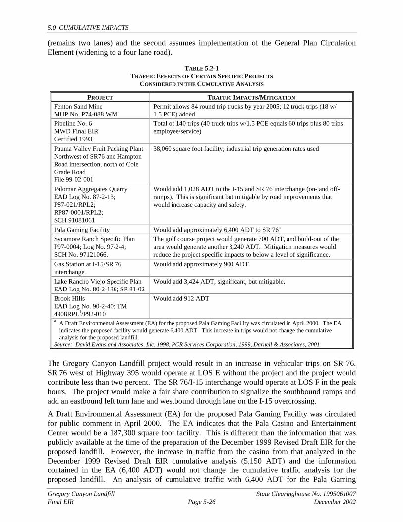
5.2.5 TRAFFIC AND CIRCULATION A near term and year 2020 cumulative analyses of traffic impacts were conducted as part of the traffic study and are described in detail in Section 4.5. Projects included in the near term cumulative analysis are identified in Table 5.2-1 and are those from the list that would contribute to traffic on SR 76. The 2020 analysis are based on SANDAG Series 8 Model forecast numbers.
5.2.5.1 Existing Conditions
Section 4.5.1 presents a discussion of existing conditions associated with traffic and circulation in the project area, including roadway configuration, traffic volumes, and existing levels of service.
5.2.5.2 Thresholds of Significance
Section 4.5.2 identifies the significance criteria for impacts relative to traffic and circulation as impacts which would reduce the level of service of an intersection or roadway segment to below LOS D during the morning or afternoon peak hour. A cumulatively significant traffic and circulation impact would result if the proposed project, when added to other projects evaluated for the cumulative effects analysis (see Section 5.1), causes the level of service for an intersection or roadway segment to fall below LOS D.
5.2.5.3 Project Effects and Determination of Cumulative Significance
The projects listed in Table 5.2-1 summarizes projects and traffic contributed in the near term cumulative analysis. Two full buildout, year 2020, scenarios using forecast numbers from SANDAG’s Series 8 Model, were analyzed. One scenario assumes no improvements to SR 76
5.0 CUMULATIVE IMPACTS
Gregory Canyon Landfill State Clearinghouse No. 1995061007 Final EIR Page 5-26 December 2002
(remains two lanes) and the second assumes implementation of the General Plan Circulation Element (widening to a four lane road).
TABLE 5.2-1 TRAFFIC EFFECTS OF CERTAIN SPECIFIC PROJECTS
CONSIDERED IN THE CUMULATIVE ANALYSIS
PROJECT TRAFFIC IMPACTS/MITIGATION Fenton Sand Mine MUP No. P74-088 WM
Permit allows 84 round trip trucks by year 2005; 12 truck trips (18 w/ 1.5 PCE) added
Pipeline No. 6 MWD Final EIR Certified 1993
Total of 140 trips (40 truck trips w/1.5 PCE equals 60 trips plus 80 trips employee/service)
Pauma Valley Fruit Packing Plant Northwest of SR76 and Hampton Road intersection, north of Cole Grade Road File 99-02-001
38,060 square foot facility; industrial trip generation rates used
Palomar Aggregates Quarry EAD Log No. 87-2-13; P87-021/RPL2; RP87-0001/RPL2; SCH 91081061
Would add 1,028 ADT to the I-15 and SR 76 interchange (on- and off-ramps). This is significant but mitigable by road improvements that would increase capacity and safety.
Pala Gaming Facility Would add approximately 6,400 ADT to SR 76a Sycamore Ranch Specific Plan P97-0004; Log No. 97-2-4; SCH No. 97121066.
The golf course project would generate 700 ADT, and build-out of the area would generate another 3,240 ADT. Mitigation measures would reduce the project specific impacts to below a level of significance.
Gas Station at I-15/SR 76 interchange
Would add approximately 900 ADT
Lake Rancho Viejo Specific Plan EAD Log No. 80-2-136; SP 81-02
Would add 3,424 ADT; significant, but mitigable.
Brook Hills EAD Log No. 90-2-40; TM 4908RPL1/P92-010
Would add 912 ADT
a A Draft Environmental Assessment (EA) for the proposed Pala Gaming Facility was circulated in April 2000. The EA indicates the proposed facility would generate 6,400 ADT. This increase in trips would not change the cumulative analysis for the proposed landfill.
Source: David Evans and Associates, Inc. 1998, PCR Services Corporation, 1999, Darnell & Associates, 2001
The Gregory Canyon Landfill project would result in an increase in vehicular trips on SR 76. SR 76 west of Highway 395 would operate at LOS E without the project and the project would contribute less than two percent. The SR 76/I-15 interchange would operate at LOS F in the peak hours. The project would make a fair share contribution to signalize the southbound ramps and add an eastbound left turn lane and westbound through lane on the I-15 overcrossing.
A Draft Environmental Assessment (EA) for the proposed Pala Gaming Facility was circulated for public comment in April 2000. The EA indicates that the Pala Casino and Entertainment Center would be a 187,300 square foot facility. This is different than the information that was publicly available at the time of the preparation of the December 1999 Revised Draft EIR for the proposed landfill. However, the increase in traffic from the casino from that analyzed in the December 1999 Revised Draft EIR cumulative analysis (5,150 ADT) and the information contained in the EA (6,400 ADT) would not change the cumulative traffic analysis for the proposed landfill. An analysis of cumulative traffic with 6,400 ADT for the Pala Gaming
5.0 CUMULATIVE IMPACTS
Gregory Canyon Landfill State Clearinghouse No. 1995061007 Final EIR Page 5-27 December 2002
Facility does not change the cumulative traffic results as contained in the December 1999 RDEIR. (Please see Appendix I of this Final EIR for the revised cumulative analysis.)
In the year 2020 with the implementation of the General Plan Circulation Element improvements (widening to a four lane road) and the improvements needed in the near term scenario, the intersections would operate at LOS D. With a four lane roadway, all segments of SR 76 from west of Highway 395 going east past the project site would operate at LOS B or better. In the year 2020 scenario without the General Plan Circulation Element improvements the roadway segments, except Couser Canyon to the project access, in the a.m. and p.m. peak would operate at LOS E or F. Couser Canyon to the project access would operate at LOS D in the a.m. peak and LOS E in the p.m. peak. Therefore, the project would have a cumulative impact on the level of service on the roadway segments.
Future improvements to SR 76 are being considered by Caltrans west of the site. Six alignments have been proposed as discussed in Section 4.5.
5.2.5.4 Pipeline No. 6
Potential impacts related to road crossings, where probable detours to temporary pavement would be required to avoid full road closures, are expected at SR 76, SR 79, and at Anza and Pala-Temecula Roads. Potential impacts from partial road closures and access restrictions at roadway crossings are expected in the project vicinity at Couser Canyon and West Lilac Roads.
Potential impacts are expected on Link 20a (Exhibit 5-2) due to the 40 trucks per day which will be transporting muck/spoil material from the portal graded area and staging area to a gravel pit to the east along SR 76. Traffic associated with the staging area along Link 20b (Exhibit 5-2) would cause potential impacts to SR 76. Potential traffic impacts from staging area activities during construction along Link 24b are expected to SR 76 (Exhibit 5-2).
Public health and safety may be impacted if, during construction, roadways which provide routes for emergency vehicles (i.e., fire trucks, paramedics, etc.) are temporarily blocked, thus reducing access. Given that portions of the pipelines would be constructed in road rights-of-way and perpendicular to existing roads, several roads would be temporarily closed during the construction period. Based on the duration of closure and size of construction area, this could result in delays to traffic, rerouting traffic to alternate roads or construction of temporary pavement to provide for through access adjacent to the activity.
Pipeline No. 6 itself will result in a short term reduction in level of service on certain roadways in the project area during construction. This effect will contribute cumulatively to a reduced level of service caused by other projects occurring simultaneously in the same area, which could result in a negative impact on traffic. These short term impacts may be partially mitigated, but depending on the scheduling of these various projects, it is possible that traffic could be significantly impacted over the short term if multiple projects are under construction at the same time in the same general area.
Over the long term, Pipeline No. 6 is not expected to generate measurable trip activity throughout the study area. Therefore, Pipeline No. 6 is not expected to contribute to potential regional, subregional and/or local cumulative traffic impacts.
For all portions of Pipeline No. 6 where traffic impacts are expected to occur due to construction or maintenance of the pipeline, one standard mitigation measure will be required. This is the work zone traffic control plan, which will be required by each jurisdiction issuing an
5.0 CUMULATIVE IMPACTS
Gregory Canyon Landfill State Clearinghouse No. 1995061007 Final EIR Page 5-28 December 2002
encroachment permit for construction of the pipeline. The work zone traffic control plan shows all signing, striping, delineation, detours, and any other devices which will be used during construction to guide motorists safely through the construction zone. MWD and SDCWA construction contractors will coordinate traffic diversions, street and land closure, and obstruction of intersections with the affected jurisdiction prior to commencing construction activities through the development of routing and detour plans. The applicable jurisdiction will enforce the provisions of the traffic control plan. Implementation of the work zone traffic control plan will reduce impacts below a level of significance.
Appropriate fire, paramedic and law enforcement providers will be notified at least two days prior to access restriction. Emergency vehicles will be allowed through access in the construction zone and full access to residences and businesses.
5.2.5.5 Mitigation Measures for Cumulative Impacts
Mitigation measures are directed at reducing cumulative impacts associated with traffic to below a level of significance. The success of regional mitigation depends in large part on the scheduling of mitigation in concert with development. The previously identified cumulative impact to the I-15/SR 76 southbound ramp intersection and the corresponding mitigation measure have been deleted from this project since Caltrans has installed a signal at this intersection subsequent to the 1999 traffic study, thus removing the impact. The updated existing conditions are included in the supplemental traffic study in Appendix I. The project would contribute a fair share contribution for the addition of an eastbound left turn lane and westbound through lane on the I-15 overcrossing. Because the levels of service on roadway segments would be below LOS D without implementation of the General Plan Circulation Element improvements, the applicant shall make an irrevocable offer of dedication for right-of-way to four lanes within the project site for future widening of SR 76 per the Circulation Element improvements. In addition, the applicant shall provide a fair share contribution for the cost to provide four lanes on SR 76 from the western boundary of the project site to the project access. Although this mitigation could constitute a fair share contribution, because of the uncertainty of the implementation of future improvements to SR 76 between I-15 and the western boundary of the project site, the cumulative traffic impact is considered significant and unmitigable.
5.2.6 NOISE AND VIBRATION Cumulative noise and vibration impacts are analyzed for H.G. Fenton Company Sand Mine, Palomar Aggregate Rock Quarry, Calmat-Pala Aggregate Mine, Pipeline No. 6, Pala Indian Gaming Facility, Sycamore Ranch Specific Plan, Campus Park Specific Plan, Lake Rancho Viejo Specific Plan, Brook Hills, Dulin Ranch and Pauma Valley Fruit Packing Plant.
5.2.6.1 Existing Conditions
Section 4.6.1 presents a discussion of existing conditions associated with noise and vibration. The discussion includes a description of noise measurement scales, noise regulations, and existing noise levels in the project area, and describes vibration associated with blasting for the project.
5.0 CUMULATIVE IMPACTS
Gregory Canyon Landfill State Clearinghouse No. 1995061007 Final EIR Page 5-29 December 2002
5.2.6.2 Thresholds of Significance
Section 4.6.2 identifies the thresholds of significance for direct impacts associated with noise and vibration. Cumulatively significant noise impacts would result if noise impacts associated with the proposed project, when added to the noise anticipated with other projects evaluated for the cumulative effects analysis (see Section 5.1), are considerable, or compound or exacerbate other environmental impacts. Cumulative noise impacts would occur:
• If projects cumulatively generate a significant increase in traffic-related noise that has the potential to affect a sensitive receptor; and
• Applicable noise standards are exceeded.
For vibration, cumulatively significant impacts would result if blasting associated with the proposed project, when added to other projects described in Section 5.1, has the potential to exceed the U.S. Bureau of Mines RI 8507 standards.
5.2.6.3 Pipeline No. 6
Most tunneling will be accomplished by tunnel boring machines that could create loud noise levels from both the machine drive as well as the rotary cutter. Cutters are electrically driven, but lack of available electricity of proper voltage requires use of combustion driven motor generators at many remote tunneling locations. Noise levels from tunnel machines have been measured at 100 dB at 50 feet from the cutting head. The cutting noise diminishes rapidly as the machine advances down the tunnel, particularly as any trailing equipment creates a noise propagation baffle. The noise impact zone at the start of operations could extend out to about 1,000 feet except that the tunneling process becomes more rapidly self-mitigating. Placement of a tunnel portal within 1,000 feet of a direct line-of-sight of any home would be a source of possible noise impacts.
Once the noise of the tunnel boring machine becomes less dominant, secondary noise sources in the portal area assume greater significance. Sources include ventilation fans, dewatering pumps, water pumps to cool the cutter, possible operation of the generator, a muck extraction system (conveyor or wheeled vehicles), and trucks to bring in materials and haul away drilling cuttings. Although the noise sources are less intense than when the tunneling machine first begins operations, they are a chronic noise source. Ventilation fan noise may be from 80 to 90 dB at 50 feet with a considerable amount of acoustic energy in the higher end of the frequency spectrum. The higher-pitched whine is annoying to humans. High frequencies are absorbed more quickly than low pitched “rumble,” such that any distance constraints recommended for portal separation from the nearest homes will more than adequately protect potential receiver locations.
Construction of the project along the Central Alignment would result in noise impacts to approximately 30 residences. These impacts relate to highly (within 160 feet) and partially (within 110 feet) mobile equipment located adjacent to these residential noise receptors. Impacts would also result from nocturnal construction activities within 500 feet of residences. Sensitive receptors that would experience these impacts occur along most of the Central Alignment.
Tunneling activities such as driving piles for any support structures, blasting for tunnel entry, etc. have maximum potential for short-term construction noise impacts. Impacts are identified at the Mt. Olympus south portal to approximately six residences: in the vicinity of SR 76 and within 500 feet of the south portal. These impacts are expected to result from diesel generators and
5.0 CUMULATIVE IMPACTS
Gregory Canyon Landfill State Clearinghouse No. 1995061007 Final EIR Page 5-30 December 2002
exhaust fans that may be operated during night-time tunneling. Impacts may also occur from grading equipment for portal preparation and construction of any access roads.
In areas where several land developments are proposed in close proximity to each other, these projects will each contribute to a cumulative impact on ambient noise levels in the surrounding area. Due to the distribution of these projects over the area surrounding Pipeline No. 6, very few of the land development projects will contribute to a cumulative effect with other projects. Noise impacts associated with implementation of Pipeline No. 6 are related to construction activities and are temporary in nature. Any cumulative effects would exist for the duration of construction activities and would be dependent on the proximity and the phasing of land development projects in relation to Pipeline No. 6. As Pipeline No. 6 will largely be an underground pipeline, it is not expected to result in any long term noise related impacts. Therefore, although Pipeline No. 6 may, depending on the timing of various land use projects, contribute to short term high noise levels during construction, it is not expected to contribute to any long term cumulative noise impacts in the study area.
5.2.6.4 Project Effects and Determination as to Cumulative Significance
Project traffic would result in a significant and unmitigable noise along SR 76 to a cluster of residences on the north side of SR 76 between I-15 and Rice Canyon Road. Project traffic when added to existing plus forecast traffic volumes in the area, would result in cumulatively significant and unmitigable noise impacts on the cluster of residences described above and an additional residence on the north side of SR 76 just west of the project site. The project would contribute to the daytime traffic noise since the hours of operation would be from 7:00 a.m. to 6:00 p.m. Monday through Friday and 8:00 a.m. to 5:00 p.m. on Saturday.
While a five-foot sound wall could reduce the project’s contribution to cumulative noise impacts, because the applicant does not own the property and the property owner is opposed to its installation, the mitigation measure is considered infeasible.1 Therefore, the project would contribute to a cumulative and unmitigable noise impact from traffic to these existing residences. Depending on the ultimate plans for SR 76, if a sound wall is installed, the applicant shall make a fair-share contribution based on the project contribution to the cumulative noise from traffic along SR 76.
For those projects listed in Table 5.1-2 that would generate project-specific significant noise impacts, mitigation measures have been identified as conditions of project approval to reduce those noise impacts to below a level of significance.
The project would require blasting of bedrock material to create the landfill. Other projects planned in the area, such as the MWD Pipeline No. 6 project, may also require blasting. Blasting would generate vibration effects in the area. Blasting impacts would be short-term and intermittent in nature.
To the extent feasible, construction shall be limited to the hours specified in applicable local noise ordinances. The construction contractor will incorporate feasible muffling features into construction vehicles and equipment and into construction methods, and will maintain all construction vehicles and equipment in efficient operating order. MWD and SDCWA will consult with local planning jurisdictions in order to determine and select the most feasible haul 1 William Pankey, the property owner of the residences west of Couser Canyon Road, has indicated to the
applicant that he does not want a sound wall installed on that property.
5.0 CUMULATIVE IMPACTS
Gregory Canyon Landfill State Clearinghouse No. 1995061007 Final EIR Page 5-31 December 2002
routes to minimize noise impacts in residential areas and in the vicinity of the noise receptors. Residents and other sensitive receptors within 300 feet of the alignment shall receive notification prior to construction stating the approximate dates of equipment operations in their area. The notification shall contain a contact telephone number of the contractor and of the appropriate code enforcement operator where any noise complaints may be lodged.
5.2.6.5 Mitigation Measures for Cumulative Impacts
Cumulatively significant traffic related noise impacts to existing residences on SR 76 would be considered by Caltrans during the design of the proposed improvements to that highway. No mitigation, other than that already incorporated into the project for project-specific impacts, would be required for blasting impacts, since they would not be cumulatively significant.
AIR QUALITY Cumulative impacts to air quality are analyzed for H.G. Fenton, Palomar Aggregates, Pipeline No. 6, Pala Gaming Facility, Sycamore Ranch Specific Plan, Campus Park Specific Plan, Lake Rancho Viejo Specific Plan, Brook Hills, Gas Station, Pauma Valley Fruit Packing Plant, and Dulin Ranch.
5.2.7.1 Existing Conditions
Section 4.7.1 describes the existing air quality conditions of the project site, surrounding area and the San Diego Air Basin. Included in this discussion is the area’s meteorology/climate, the regulatory framework for establishing air quality goals and criteria, the existing air quality environment, and odors. Regionwide planning documents also address existing conditions relative to air quality. These include the San Diego Regional Air Quality Strategy (RAQS).
5.2.7.2 Thresholds of Significance
Section 4.7.2 identifies the thresholds of significance for air quality impacts. Because a single project rarely results in a significant air quality impact by itself, the quality of the region’s air is cumulative by nature. Therefore, the significance criteria presented in Section 4.7.2.1 apply to the discussion of cumulative air quality effects as well as to project-specific impacts.
5.2.7.3 Pipeline No. 6
Air quality impacts will primarily be short-term in duration during construction. Air pollutants generated by the construction equipment at the site will be emitted into the atmosphere. Secondary construction-related impacts to air quality will result from fugitive dust emitted from site grading and clearing. Air pollutants will also be emitted by vehicles during the commute to and from the pipeline site(s). Long-term operation-related impacts to air quality are extremely minor or incremental since water conveyance and routine maintenance activities result in few emissions of air pollutants.
Short-term impacts to localized air quality will result from construction of the proposed pipeline. Emissions generated by construction activities cannot be quantified with 100 percent certainty because data regarding the exact numbers and types of equipment to be used have not been finalized. The sources of construction air pollutant emissions are construction equipment, trucks and diesel locomotives. The tunnel boring machine is electrically powered and therefore does not directly contribute to air pollution. The number of trucks per day at the tunnel construction
5.0 CUMULATIVE IMPACTS
Gregory Canyon Landfill State Clearinghouse No. 1995061007 Final EIR Page 5-32 December 2002
portal sites is variable and depends on the tunnel advance rate and the stage of construction (i.e., tunnel cleanup, concrete lining, etc.).
Other sources of air pollution include particulate matter associated with windblown dust, primarily from haul roads, access roads, and dust from ventilation fans, and gas and particulate matter from blasts. Moisturizing the muck/spoil in the tunnel heading and/or installation of dust collectors could reduce dust from the ventilation fans. Applying asphalt, water or stabilizing materials to dirt roads and open excavations is commonly used for controlling dust.
While progressive construction limits the duration of soil disturbance and equipment emissions at any residence or other pollution sensitive receptor, staging areas represent a somewhat longer-term source. Potential impacts center mainly on dust emissions resulting from travel on an unpaved surface at the staging area. With reasonable maintenance, dust impacts can be confined to within a few hundred feet of the staging area.
While light winds maximize sensitivity near construction areas, strong Santa Ana winds are a concern as dust from localized soil disturbance can be blown for considerable distance from the site during these windstorms. The dominant Santa Ana wind direction is from the northeast. If local canyons also trend northeast-southwest, they funnel winds and cause them to be further accelerated with increased dust transport. Canyons such as Couser and Keys Canyons, which trend more northwest-southeast are better protected from the strongest winds, but there is considerable “swirl” which also may exacerbate dust and construction debris scattering problems. Construction in complex terrain thus needs to incorporate adequate dust control procedures to minimize extensive dust generation during Santa Ana wind conditions.
Adequate water or other dust palliatives will be used on all disturbed areas. Paved streets from which site access is taken will be washed down or swept to remove dirt carried from the site to the street in order to keep vehicles from pulverizing the dirt into fine particles. All vehicles hauling dirt or spoils on public roadways will be covered or tarped unless additional moisture is added to prevent material blow-off during transport. Construction equipment will be maintained by keeping them properly tuned and equipment will be operated in an efficient manner to reduce peak emission levels. Rideshare or transit incentives will be provided for construction personnel. Obstruction of through traffic lanes from construction equipment or activities will be minimized to the greatest extent possible.
Air quality impacts generated will predominately be short term, related to construction. Short term emissions of carbon monoxide, nitrogen oxide, fugitive dust and particulates generated during the construction of Pipeline No. 6 may contribute to significant short term cumulative construction emissions from other projects in the immediate vicinity which occur simultaneously.
5.2.7.4 Project Effects and Determination of Cumulative Significance
The basis of evaluating the project's cumulative air quality impact is the San Diego Regional Air Quality Strategy (RAQS) as approved by the San Diego Air Pollution Control District (APCD). The APCD is the designated governmental body in charge of monitoring air quality and promulgating emission control tactics. In addition to the emission control tactics, the RAQS forecasts future air quality conditions based on population growth, as projected by the San Diego Association of Governments (SANDAG). These forecasts, rather than the evaluation of specific future projects, are the foundation for predicting the impact of future development on the San Diego Air Basin (SDAB) along with the evaluation of air quality impacts from individual projects in conjunction with future development.
5.0 CUMULATIVE IMPACTS
Gregory Canyon Landfill State Clearinghouse No. 1995061007 Final EIR Page 5-33 December 2002
Based on data from the regional air quality monitoring network, the State Air Resources Board has classified the SDAB as a nonattainment area with respect to both the state and the federal standards for ozone and for the state particulate matter (PM10) standard. Furthermore, since carbon monoxide (CO) concentrations exceed both state and federal standards in downtown San Diego and in Escondido, the western portion of the air basin (comprising most of the urbanized areas of San Diego) is classified as a CO nonattainment area. In addition to build-out of the region as anticipated by community and subregional plans, individual projects (such as those listed in Table 5.1-2) may contribute to the degradation of regional air quality.
As discussed in Section 4.7, Air Quality, of this EIR, project-generated emissions would exceed the significance thresholds for PM10 and NOX and would contribute incrementally to the air basin’s inability to achieve air quality standards. Therefore, cumulative impacts for these emissions would be considered significant.
5.2.7.5 Mitigation Measures for Cumulative Impacts
Implementation of the tactics presented in the RAQS are directed at mitigating regionally significant air quality impacts. The effectiveness of such measures are dependent upon sound land planning, emission reductions through more efficient automobiles, and trip reducing techniques and other tactics. Because the success of the RAQS is unknown and relies on factors outside the control of an individual project, the proposed project’s incremental contribution to regional emissions, when considered with other projects in the area and buildout of the region as anticipated by the General Plan, community plans, and subregional plans, is considered cumulatively significant. It is not mitigable at a project level.
5.2.8 AGRICULTURAL RESOURCES Cumulative impacts to agricultural resources are analyzed for H.G. Fenton Company Sand Mine, Palomar Aggregate Rock Quarry, Calmat-Pala Aggregate Mine, Pipeline No. 6, Sycamore Ranch Specific Plan, Campus Park Specific Plan, Lake Rancho Viejo Specific Plan and Dulin Ranch.
5.2.8.1 Existing Conditions
Section 4.8.1 presents a discussion of existing conditions for on-site and off-site agricultural resources. As described in Section 4.8.1, portions of the project site have been used for agricultural endeavors in the past, and agriculture continues in the project vicinity.
5.2.8.2 Thresholds of Significance
Section 4.8.2 identifies the thresholds of significance for direct impacts to agricultural resources. Cumulatively significant impacts would result if development of the project site, in concert with anticipated development in the area (see Section 5.1), would substantially affect the viability of agriculture in the region.
5.2.8.3 Pipeline No. 6
See 5.2.1.3 Land Use.
5.2.8.4 Project Effects and Determination Cumulative Significance
Development of the proposed project would not result in impacts to agricultural resources. Prime agricultural soils on the project site occur in isolated areas totaling 76 acres, of which the
5.0 CUMULATIVE IMPACTS
Gregory Canyon Landfill State Clearinghouse No. 1995061007 Final EIR Page 5-34 December 2002
project would directly impact 7.4 acres. The prime agricultural soils that do occur on the site have been disturbed and are considered to be of low value relative to their past and present uses and their suitability for economically viable future cultivation. Nonetheless, prior to the passage of Proposition C, portions of the project site had been identified as agricultural preserves on the County’s Agricultural Preserve Map. The loss of agricultural lands on the project site, when added to development pressure in the area, could result in cumulative impacts to agricultural resources.
The project’s impacts to prime agricultural soils occurring in the county represents approximately 0.005 percent of the county’s inventory. As presented in Section 4.8 of this EIR, large contiguous areas of prime agricultural soils are available for cultivation in the project vicinity and regionally, and locally and regionally prime agricultural soils are available in sufficient quantity to continue agricultural activities. County planning tools have identified areas of agricultural importance, and these areas are designated for agricultural pursuits in regional planning documents and through zoning. The proposed project and the related projects included in Section 5.2.8 Agricultural Resources of this Final EIR do not fall within lands designated as either intensive agriculture or agricultural preserve, as delineated on Figure 1-5 of the Final Environmental Impact Report for Agricultural Issues General Plan Amendment and Implementing Rezone (GPA 96-03) prepared by the County of San Diego in January 2000. The intensive agriculture designation is applied to approximately 27,600 acres of land within San Diego County. The agricultural preserve designation covers approximately 191,000 acres of land within San Diego County. As shown on Figure 1-2, only one of the related projects, Campus Park Specific Plan, is located within an area containing prime agricultural soils. The Campus Park Specific Plan contains approximately 375 acres of prime agricultural soils. The proposed project contains approximately 76 acres of prime agricultural soils. Therefore, a cumulative total of approximately 451 acres of prime agricultural soils would be lost due to the development of the proposed project in combination with related projects. This would not result in a significant cumulative impact to agricultural resources, since it is estimated that there are approximately 162,000 acres of prime agricultural soils in San Diego County. The proposed project in combination with related projects would result in a cumulative loss of 0.28 percent of this total. The proposed project in combination with related projects would not result in significant cumulative impacts to agricultural resources.
5.2.8.5 Mitigation Measures for Cumulative Impacts
The project would not result in the potential for cumulative impacts associated with agriculture. Therefore, no mitigation measures are necessary.
5.2.9 BIOLOGICAL RESOURCES The projects listed in Table 5.1-2 are considered in the biological cumulative analysis since they are located in the portion of the San Luis Rey River watershed in the project vicinity.
5.2.9.1 Existing Conditions
Section 4.9.1 presents a discussion of existing conditions associated with biological resources for the project site. Natural vegetation occurring on the project site includes coastal sage scrub, chaparral, native perennial grassland, coast live oak woodland, and wetland habitats. Regional open space and habitat planning documents listed in Section 5.1.4 include a general description of habitats on a region-wide level.
5.0 CUMULATIVE IMPACTS
Gregory Canyon Landfill State Clearinghouse No. 1995061007 Final EIR Page 5-35 December 2002
5.2.9.2 Thresholds of Significance
Section 4.9.2 identifies the thresholds of significance for direct impacts associated with biological resources. Cumulatively significant impacts would result when project impacts to native habitat are added to those from other projects in the vicinity (see Section 5.1). Cumulative biological resources impacts would occur if the project, in conjunction with other projects, would:
• Cumulatively result in adverse impacts to a state or federally listed species or its habitat; • Contribute to a cumulative reduction in the number of unique or rare species which would
affect the species’ long-term viability; • Cause development which permanently disturbs a wildlife corridor or disrupts its use for an
extended period; • Result in a cumulative effect to a sensitive habitat which is regionally limited; or • Result in a cumulative conflict with long-term regional or subregional conservation goals.
5.2.9.3 Pipeline No. 6
Pipeline 6 would result in direct impacts to coastal sage scrub, agricultural lands and developed habitats on site, in descending order of extent. A 300-foot long tunnel beneath the river is proposed to avoid the majority of impacts to the riparian habitat on site. However, because the section of the river being crossed is wider than 300 feet, it would be expected that southern willow scrub habitat on either end of the tunnel would be impacted. A portion of the tunnel’s riparian habitat impacts would overlap with those anticipated for the channel excavation proposed beneath the landfill access bridge. Approximately half of the upland habitat disturbed by trenching operations would be coastal sage scrub; a portion of these impacts near the southern property boundary would overlap with those associated with Borrow/Stockpile Area B. Much of the native habitat disturbed during pipeline construction would be revegetated, however a permanent 15- to 20-foot wide patrol road may be created if the existing access road is not sufficient to patrol all three pipelines. As noted in the Pipeline 6 environmental document, impacts of the construction staging area would be considered significant due to its proximity to the San Luis Rey River. Disturbance of coastal sage scrub would also constitute a significant impact due to its sensitivity in the region. Both projects would, however, increase the amount of protected coastal sage scrub habitat in the County. In the event that Pipelines 1 and 2 and the easement for Pipeline 6 are relocated westerly of their present location in the corridor shown on Exhibit 5-3, cumulative impacts to native habitat associated with Pipeline 6 would be generally similar for riparian resources, but increased for coastal sage scrub and live oak woodland.
Similar to the Gregory Canyon Landfill project, potentially significant indirect effects associated with pipeline construction would include the increased presence of human activity (in the form of construction workers, delivery vehicles, and heavy equipment) for a period of five years; degradation of water quality; increased noise levels and fugitive dust; increased habitat fragmentation; introduction of invasive species; and the temporary interruption of wildlife corridors, among other potential effects. Because the initial construction periods for the two projects would not directly overlap, the majority of construction-specific cumulative impacts would be minimized. However, landfill operations and cell construction could be on-going throughout the pipeline construction period and could lead to periodic cumulative impacts.
The presence of construction personnel and equipment on site would incrementally add to levels expected during landfill operations. Both projects would be more active during daylight hours
5.0 CUMULATIVE IMPACTS
Gregory Canyon Landfill State Clearinghouse No. 1995061007 Final EIR Page 5-36 December 2002
when increases in human activity on site would be least disruptive to wildlife. In addition, the majority of human activity (i.e., 24-hour construction) proposed on site for the pipeline would be at the Mt. Olympic tunnel portal, which is approximately 1,000 feet from the landfill operations, thus minimizing the cumulative effects. Short-term increases in soil erosion, sedimentation rates and the potential for re-fueling spills near natural drainages would be minimized during both construction projects through the implementation of stormwater pollution prevention measures required by the RWQCB. Dewatering required for pipeline tunneling, landfill construction and landfill operations would not cumulatively degrade resources in the river since groundwater discharged into the river could enhance the riparian habitat. Construction noise from the pipeline could combine with landfill operational noise to increase noise exposure of wildlife, in particular breeding birds in the San Luis Rey River, above 60 dB(A) Leq. However, noise mitigation would be implemented by both projects to avoid cumulative impacts. Dust control mitigation required of both projects should minimize migration onto adjacent native habitats and avoid cumulative impacts. Habitat fragmentation caused by trenching operations and landfill construction would be phased on site and revegetation of disturbed areas would minimize this cumulative impact. Both projects would be required to revegetate with native species, nonetheless, the potential for invasives to be introduced on site would worsen with pipeline construction due to the permanent removal of native habitat for the maintenance road. Temporary interruptions in wildlife movement due to construction activities would not be expected since the construction activities in the river would not overlap. However, night lighting associated with construction and pipeline staging areas could degrade the quality of the river corridor and cumulatively increase nighttime predation of species in the river.
In terms of species-specific impacts, both projects would result in significant impacts to the arroyo southwestern toad, least Bell’s vireo and southwestern willow flycatcher due to the increased human activity and use of heavy construction equipment within their habitat on site (within the river and up to 2.0 km from the river). There is the potential to adversely affect the California gnatcatcher due to the removal of coastal sage scrub, although breeding populations have not been typically found in the project area. Depending on construction timing and its proximity to sensitive areas, these species could experience increased stress and disruption of breeding behavior during both construction periods. Habitat restoration, habitat creation and operational measures would be required of both projects by the Wildlife Agencies to mitigate potential short and long-term impacts to endangered species.
5.2.9.4 Project Effects and Determination of Cumulative Significance
County-Wide Open Space And Resource Mapping
For an evaluation of cumulative impacts associated with biological resources and wildlife habitat, information obtained from SANDAG provides a regional perspective to remaining habitats throughout the County. The population, housing and employment growth of the 1980s resulted in a loss of natural habitats and the listing of a number of species as endangered, threatened or rare that was unparalleled in the past. The need to balance the protection of the region’s remaining natural resources with the need to accommodate future projected growth culminated in the development of habitat conservation plans for the region.
In the early 1990s, vegetation databases were created to provide a biological framework to support the region’s on-going habitat conservation efforts. These habitat conservation programs include: the City of San Diego’s MSCP, the North County Multiple Habitat Conservation
5.0 CUMULATIVE IMPACTS
Gregory Canyon Landfill State Clearinghouse No. 1995061007 Final EIR Page 5-37 December 2002
Program (MHCP) and the County’s Multiple Habitat Conservation Program (MSCP). The Gregory Canyon site falls within the study area for the ongoing North County MSCP Subarea.
Table 5.2-2 provides a tabulation of the various generalized habitat types, their estimated acreage in 1990 and 1995 and the degree of change that has occurred in that period. The degree of change represents the cumulative loss of native vegetation and, when considered with other anticipated projects in the area, can provide a basis for estimating the project’s contribution to cumulative effects associated with biological resources. Shaded table entries indicate the generalized habitat types which occur on the project site and which could be affected by the Gregory Canyon Landfill project.
Until a conservation plan is approved for many unincorporated areas of the County, including the North County MSCP Subarea, impacts to coastal sage scrub habitat are regulated through a special rule under Section 4(d) of the Federal Endangered Species Act, which authorizes incidental take of the coastal California gnatcatcher in conjunction with an approved plan under the California Natural Communities Conservation Plan (NCCP) established by the governor in 1991. The NCCP guidelines indicate that a five percent loss of coastal sage scrub within any individual subregion is acceptable during the preparation of a subregional plan. Within northern San Diego County, the total allowable take of coastal sage scrub under the 4(d) rule is 1,876.9 acres. With approved and pending losses (170.33 acres) removed from the total, the remaining habitat in the unincorporated lands north of Highway 78 is 1,706.57 acres (County 1998).
Despite this project's contribution which includes dedication of 1,313 acres of open space, the proposed project would add to the incremental losses of native habitat in the North County and the region as a whole which, when considered with past, present, and reasonably foreseeable projects, could result in cumulatively significant impacts due to the decline of sensitive habitats on a regional level. The proportionate loss of native habitats associated with the proposed project, when considered on a regional level, is presented in Table 5.2-3.
The NCCP guidelines indicate that a five percent loss of coastal sage scrub habitat is acceptable within any individual subregion during the time the jurisdiction is preparing a subregional conservation plan. As noted above, for the North County this loss is estimated at 1,706.57 acres. The proposed project’s loss of 178.8 acres of coastal sage scrub and 44.1 acres of coastal sage scrub/chaparral habitat would contribute incrementally to the region’s loss, but not cause the County to exceed its five percent allowable loss of habitat for the North County. When considered with other projects in the northern San Diego area and the project vicinity, the cumulative impacts to coastal sage scrub habitat would still not exceed the County’s five percent allowable loss.
TABLE 5.2-2 GENERALIZED VEGETATION CHANGES, 1990-1995—SAN DIEGO REGION a
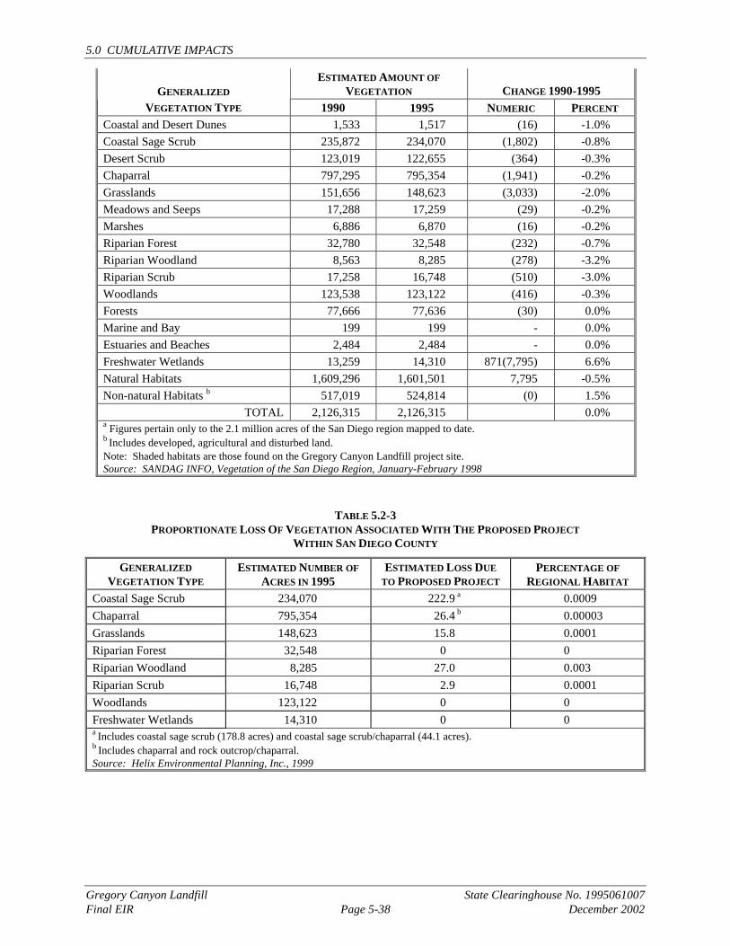
5.0 CUMULATIVE IMPACTS
Gregory Canyon Landfill State Clearinghouse No. 1995061007 Final EIR Page 5-38 December 2002
ESTIMATED AMOUNT OF VEGETATION CHANGE 1990-1995 GENERALIZED
VEGETATION TYPE 1990 1995 NUMERIC PERCENT Coastal and Desert Dunes 1,533 1,517 (16) -1.0% Coastal Sage Scrub 235,872 234,070 (1,802) -0.8% Desert Scrub 123,019 122,655 (364) -0.3% Chaparral 797,295 795,354 (1,941) -0.2% Grasslands 151,656 148,623 (3,033) -2.0% Meadows and Seeps 17,288 17,259 (29) -0.2% Marshes 6,886 6,870 (16) -0.2% Riparian Forest 32,780 32,548 (232) -0.7% Riparian Woodland 8,563 8,285 (278) -3.2% Riparian Scrub 17,258 16,748 (510) -3.0% Woodlands 123,538 123,122 (416) -0.3% Forests 77,666 77,636 (30) 0.0% Marine and Bay 199 199 - 0.0% Estuaries and Beaches 2,484 2,484 - 0.0% Freshwater Wetlands 13,259 14,310 871(7,795) 6.6% Natural Habitats 1,609,296 1,601,501 7,795 -0.5% Non-natural Habitats b 517,019 524,814 (0) 1.5%
TOTAL 2,126,315 2,126,315 0.0% a Figures pertain only to the 2.1 million acres of the San Diego region mapped to date. b Includes developed, agricultural and disturbed land. Note: Shaded habitats are those found on the Gregory Canyon Landfill project site. Source: SANDAG INFO, Vegetation of the San Diego Region, January-February 1998
TABLE 5.2-3 PROPORTIONATE LOSS OF VEGETATION ASSOCIATED WITH THE PROPOSED PROJECT
WITHIN SAN DIEGO COUNTY
GENERALIZED VEGETATION TYPE
ESTIMATED NUMBER OF ACRES IN 1995
ESTIMATED LOSS DUE TO PROPOSED PROJECT
PERCENTAGE OF REGIONAL HABITAT
Coastal Sage Scrub 234,070 222.9 a 0.0009 Chaparral 795,354 26.4 b 0.00003 Grasslands 148,623 15.8 0.0001 Riparian Forest 32,548 0 0 Riparian Woodland 8,285 27.0 0.003 Riparian Scrub 16,748 2.9 0.0001 Woodlands 123,122 0 0 Freshwater Wetlands 14,310 0 0 a Includes coastal sage scrub (178.8 acres) and coastal sage scrub/chaparral (44.1 acres). b Includes chaparral and rock outcrop/chaparral. Source: Helix Environmental Planning, Inc., 1999
5.0 CUMULATIVE IMPACTS
Gregory Canyon Landfill State Clearinghouse No. 1995061007 Final EIR Page 5-39 December 2002
The project site lies within the study area for the North County Subarea of the County’s MSCP. Ongoing open space and habitat planning efforts are being conducted by the County to prepare an MSCP for unincorporated North County Subarea. At this time, vegetation mapping has been completed, but wildlife corridors and habitat linkages have not yet been defined. It is anticipated that the open space areas created as part of the project, community plans and Specific Plans in the North County area would be incorporated in the MSCP’s Subarea Plan when they are ultimately defined. Thus, many of the projects in the cumulative study area could add to the MSCP open space system through on site dedication and purchase of land within the preserve system.
The purpose of the MSCP is to provide for long-term protection of sensitive habitats through an open space design which includes a “block” of connected open space. Once implemented, the MSCP would compensate for the incremental loss of sensitive habitats on the regional level. Pursuant to Section 15130(3)(c) of the State CEQA Guidelines, adoption of the MSCP by the County would provide a feasible and comprehensive approach to mitigating cumulative impacts for the unincorporated lands of North County through habitat conservation, creating large blocks of connected open space and long-term protection for sensitive species, including the least Bell’s vireo, southwestern willow flycatcher, arroyo southwestern toad, golden eagle, and coastal California gnatcatcher. The regional open space plan would also provide long-term preservation of identified important wildlife corridors. Implementation of regional open space plans and required mitigation procedures developed in conjunction with those plans would ensure that cumulative impacts to biological resources would be reduced to below a level of significance.
Implementation of the cumulative projects (Table 5.1-2) in conjunction with the landfill would result in cumulative, direct effects on biological resources as a result of the removal of native habitats and loss of open space. Indirect effects would be expected from the secondary impacts of habitat removal, including changes in water quality/erosion rates, introduction of night lighting, increased human activity, introduction of invasive species and other development-related changes to the native landscape. Based upon environmental review records for many of the cumulative projects and a review of aerial photography and regional mapping conducting in the area, direct impacts to riparian habitat in the San Luis Rey River would be expected for several of the projects, namely, the Fenton Sand Mine, Palomar Aggregates Quarry, Pipeline 6, Calmat-Pala Sand Mine, Campus Park Specific Plan, and State Route 76 highway improvements. Endangered species dependant on the San Luis Rey River riparian corridor, such as the arroyo southwestern toad, southwestern willow flycatcher and the least Bell’s vireo, would be directly and or indirectly affected by this cumulative habitat removal. The removal of upland habitats on the hillsides surrounding the river corridor would also lead to cumulative effects on sensitive species dependant on the coastal sage scrub and chaparral communities nearby. In addition, all of these projects would contribute to the cumulative loss of raptor foraging habitat in the project area. For projects within the watershed of the river, possible indirect cumulative impacts would be expected in response to habitat fragmentation, changes in water quality, increases in night lighting, increases in human activity, introduction of invasive species, increases in short-term noise levels, increased incidence of roadkill and other effects. Each project would be responsible for implementing mitigation measures to avoid and minimize potential indirect impacts to biological resources within the watershed.
Currently, portions of the riparian habitat in the San Luis Rey River are exposed to elevated noise due to traffic along the highway. Indirect noise impacts, however, would continue to increase adjacent to Highway 76 in the future (year 2020) condition as each project considered in this cumulative analysis would add long-term traffic to the highway. Based on traffic noise
5.0 CUMULATIVE IMPACTS
Gregory Canyon Landfill State Clearinghouse No. 1995061007 Final EIR Page 5-40 December 2002
predictions along Highway 76 (from Interstate 15 to the project site), future cumulative noise levels would exceed 60 dB(A) Leq within the riparian habitat within the river. The project’s contribution in conjunction with the other projects would shift the 60 dB(A) Leq cumulative noise contour approximately 50 feet further into riparian habitat near the highway. This shift would only occur during the 30-year lifespan of the landfill and its closure would eventually reduce cumulative highway noise. However, while the landfill is operating, cumulatively significant indirect noise impacts would occur since noise could affect the breeding success of endangered bird species inhabiting this portion of the river.
5.2.9.5 Mitigation Measures for Cumulative Impacts
The purpose of the MSCP is to provide for long-term protection of sensitive habitats through an open space design which includes a “block” of connected open space. Once implemented, the MSCP will compensate for the incremental loss of sensitive habitats on the regional level. Pursuant to Section 15130(3)(c) of the CEQA Guidelines, adoption of the MSCP by San Diego County would provide a feasible and comprehensive approach to mitigating cumulative impacts for the unincorporated lands of North County through habitat conservation, creating large blocks of connected open space and long-term protection for sensitive species, including the California gnatcatcher, least Bell’s vireo, arroyo toad, and golden eagle. The regional open space plan would also provide long-term preservation of identified important wildlife corridors. Implementation of regional open space plans and required mitigation procedures developed in conjunction with those plans would ensure that cumulative impacts to biological resources would be mitigated to below a level of significance.
Despite the extensive amount of open space and native habitat in the rural area surrounding Gregory Canyon Landfill, the above-described habitat losses and indirect impacts within the San Luis Rey River watershed would be considered cumulatively significant on the basis that the San Luis Rey River and surrounding hillsides are considered a regionally significant block of habitat in San Diego County. To offset these project-specific and cumulative effects, the project applicant for Gregory Canyon Landfill would be required as biological mitigation to restore and enhance the approximately one-mile long riparian corridor in the San Luis Rey River on site. Please see the Draft Habitat Enhancement Plan contained in Appendix L of this Final EIR. This restoration effort would involve the removal of the existing and inactive Verboom and Lucio dairies, including most structures, animals, and manure built up on site after over 30 years of agricultural use. Improvements in hydrology would be made to encourage the re-establishment of riparian resources formerly filled by the agricultural operations. Exotic species currently located in the portion of the river on site, such as giant reed (Arundo donax), would be removed. All upland and drier riparian areas would be hand-seeded and regular weed control would be implemented. Together with the long-term management of the mitigation lands and large amount of dedicated open space on site, this restoration effort would mitigate cumulatively significant impacts to biological resources below a level of significance. In addition, the project applicant is in discussions with the USFWS and CDFG as part of the Section 7 consultation process and has expressed a willingness to donate funds for the possible acquisition of biologically important, off-site properties within the San Luis Rey River for open space preservation. The amount of funds and their expenditure will be determined through continued consultation. This effort would further compensate for cumulative impacts.
5.0 CUMULATIVE IMPACTS
Gregory Canyon Landfill State Clearinghouse No. 1995061007 Final EIR Page 5-41 December 2002
5.2.10 PALEONTOLOGICAL RESOURCES Cumulative impacts to paleontological resources are analyzed for Pipeline No. 6, Sycamore Ranch Specific Plan, Campus Park Specific Plan, Lake Rancho Viejo Specific Plan, Brook Hills and Dulin Ranch.
5.2.10.1 Existing Conditions
Section 4.10.1 presents a discussion of existing conditions associated with paleontological resources. As described in Section 4.10.1, the project site and surrounding areas are underlain by a complex of Mesozoic metamorphic and plutonic basement rocks overlain by unconsolidated sediments of Quaternary age. Of these formations, Quaternary alluvium may contain important paleontological resources.
5.2.10.2 Thresholds of Significance
Section 4.10.2 identifies the threshold of significance for direct impacts associated with paleontological resources. When the project’s potential impacts are considered in concert with those which could occur with other projects in the vicinity (see Section 5.1), significant cumulative impacts to paleontological resources could result. Cumulative paleontological impacts would occur if the project in conjunction with other projects would result in the cumulative disruption or destruction of important paleontological resources.
5.2.10.3 Pipeline No. 6
Pipeline No. 6 pipeline construction has the potential to disturb paleontological resources along certain segments of pipeline routes. However, no significant environmental impacts to paleontological resources would occur from the construction of Pipeline No. 6 at the Gregory Canyon Landfill site.
5.2.10.4 Project Effects and Determination of Cumulative Significance
The proposed project includes mitigation measures which ensure that, if important paleontological resources are encountered during grading activities, a data collection and recovery program would be implemented. The county requires the same level of mitigation for all development projects. Therefore, any significant impacts to paleontological resources would be mitigated to below a level of significance.
5.2.10.5 Mitigation Measures for Cumulative Impacts
The project is not anticipated to result in cumulative impacts to important paleontological resources. The project includes paleontological monitoring in the event potential resources are uncovered during grading operations. Applying similar mitigation to other county projects would ensure that impacts to paleontological resources on the regional level are adequately mitigated.
5.2.11 ETHNOHISTORY/CULTURAL RESOURCES Cumulative impacts to ethnohistory/cultural resources are analyzed for H. G. Fenton Company Sand Mine, Pala Gaming Facility, Palomar Aggregate Rock Quarry, Calmat-Pala Aggregate Mine, Pipeline No. 6, Sycamore Ranch Specific Plan, Campus Park Specific Plan, Lake Rancho Viejo Specific Plan, Brook Hills and Dulin Ranch.
5.0 CUMULATIVE IMPACTS
Gregory Canyon Landfill State Clearinghouse No. 1995061007 Final EIR Page 5-42 December 2002
5.2.11.1 Existing Conditions
Sections 4.11.1 and 4.12.1 present a discussion of existing conditions associated with archaeological and cultural resources. The historic and prehistoric background for the surrounding area, as well as for the project site are discussed in these sections.
5.2.11.2 Thresholds of Significance
Sections 4.11.2 and 4.12.2 identify the thresholds of significance for direct impacts associated with historic/ archaeological resources and ethnohistoric resources, respectively. Cumulatively significant impacts may result when the project’s impacts to significant/CR eligible cultural resources are added to the loss of other cultural resources considered to be significant on the local and regional level.
5.2.11.3 Pipeline No. 6
Staging areas, which are located in Links 20b and 24b (Exhibit 5-2), have potential impact because these locales have not been fully surveyed for archaeological sites. Impacts are anticipated to occur in Link 24b due to the presence of a previously disturbed habitation site. The southern portal of the proposed Mt. Olympus Tunnel is classified as an impact because of a previously recorded temporary camp in the immediate area. Field checks of this area were inconclusive because of the density of vegetation cover. Location of the pipeline in the corridor to the west of the central alignment could result in an impact to an archaeological site in addition to that affected by the portal.
Avoidance of impacts through placement of the pipeline outside site boundaries is the preferred mitigation measure for all prehistoric and historic sites. Preservation in place through site stabilization or capping is a mitigation measure that is occasionally employed. This option might be employed to avoid indirect impacts to a resource during and following construction.
Data recovery is generally an acceptable alternative when avoidance is not feasible. For archaeological sites, data recovery usually comprises subsurface excavation of a sample of the deposit, data analysis, report preparation and curation of recovered material and data. For rock art sites, documentation could be accomplished through photographs and drawings. For historic archaeological sites without structures, data recovery could include archival research, and, in some cases, oral interviews. Historic structures require documentation through photographs, measured drawings and historic research. The last usually includes both archival research and oral interviews.
5.2.11.4 Project Effects and Determination of Cumulative Significance
Significant/CR eligible archaeological resources, both prehistoric and historical, have been identified on the project site. In addition, Gregory Mountain, which is partially on the site, and Medicine Rock, to the north of the site, have been identified as traditional cultural resources. Existing development in and near the project site affects these cultural resources.
Archaeological/Historic Resources
Project-specific impacts to archaeological resources would be fully mitigated. Cumulative impacts to archaeological/historical sites in the project area (off-site) may result from planned or prior projects with site-specific consequences. Archaeological/historic resources have been identified on some of the related project sites. As mentioned above, resources have been
5.0 CUMULATIVE IMPACTS
Gregory Canyon Landfill State Clearinghouse No. 1995061007 Final EIR Page 5-43 December 2002
identified along the proposed alignments for Pipeline No. 6. In addition, five cultural resources were identified within or adjacent to the Pala Gaming facility. Impacts to cultural resources were also identified for Sycamore Ranch Specific Plan, Lake Rancho Viejo Specific Plan, and Dulin Ranch. No cultural resources were identified on the Palomar Aggregates or the Brooke Hills project sites. Furthermore, the Fenton Sand Mine project involves an increase in trips and not an expansion of land area. As such, no significant impact to archaeological/historic resources would result although impacts to ethnohistoric impacts could occur. Finally, the Calmat-Pala Aggregate Mine is located on reservation land and information is not available.
Each of the projects that have identified significant archaeological/ historic resources on the site have either avoided these resources, provided project-specific mitigation measures to reduce impacts to less than significant levels, or the County has imposed a condition of approval to reduce potential impacts to these resources to less than significant levels. Furthermore, it has been concluded that these projects would not contribute to significant cumulative impacts. Impacts to archaeological/historic resources resulting from the project would also be reduced to less than significant levels with the incorporation of proposed mitigation measures. Therefore, while the project would incrementally contribute to a potentially significant cumulative impact when considered along with the removal of archaeological or historic resources associated with other projects in the area, because such impacts would be mitigated, they would not be cumulatively considerable.
Ethnohistoric Resources
The Draft Environmental Assessment (EA) for the Pala Gaming Facility (April 2000) was used as a resource in determining if cumulatively significant environmental impacts would occur to the ethnohistoric resources of Gregory Mountain and Medicine Rock. The proposed Pala Gaming Facility is located approximately 1.5 east of the project site.
The Pala Gaming Facility EA has determined that the proposed gaming facility in combination with related projects would not result in significant cumulative impacts to traffic or noise after the incorporation of mitigation measures. The EA states that the proposed gaming facility would not contribute to significant cumulative impacts to the ethnohistoric resources of Gregory Mountain and Medicine Rock (Pala Gaming Facility EA, p. 86).
Other than the Pala Gaming Facility, the closest related project to the project site that was included as a related project in both the EA and the RDEIR is the Palomar Aggregate Rock Quarry. The Quarry would be located approximately 1.5 miles west of the project site. The vast majority of the quarry traffic would occur well west of the Gregory Canyon project site, between the quarry and the I-15 freeway and a substantial distance from Medicine Rock and Gregory Mountain. Therefore, no significant cumulative traffic or noise impacts to Gregory Mountain and Medicine Rock would occur from the Palomar Aggregate Rock Quarry.
An additional project not included as a related project in the EA, but included in the RDEIR, that could impact Gregory Mountain and Medicine Rock, is the H.G. Fenton Company Sand Mine. The existing sand and gravel mining operation, which is located directly north of the project site, has been operational for many years. The Major Use Permit for the operation, which allows an increase of 18 trips per year (1.5 trips per day) will expire in the year 2005. Due to the small amount of additional traffic from the Fenton project (i.e., 1.5 trips per day), cumulative traffic and noise impacts to Gregory Mountain and Medicine Rock will not occur from the Fenton project. Another potential concern from the Fenton project would be the potential effects of
5.0 CUMULATIVE IMPACTS
Gregory Canyon Landfill State Clearinghouse No. 1995061007 Final EIR Page 5-44 December 2002
cumulative dust generation to Medicine Rock or Gregory Mountain. However, the continued operation of the H.G. Fenton Company Sand Mine would be very similar to existing conditions, with indistinguishable levels of dust generation due to the small traffic increase permitted by the MUP. In addition, winds in the project area are primarily from the northwest, and therefore dust generated by the proposed project and the H.G. Fenton Company Sand Mine would not blow toward Medicine Rock or Gregory Mountain at the same time. A natural buffer currently exists between the H.G. Fenton Company Sand Mine and the ethnohistoric resources. The mine is located more than 1,200 feet from Gregory Mountain and more than 1,700 feet from Medicine Rock and is separated from both of these resources by the San Luis Rey River. This buffer will ensure that dust generation from this related project would not result in significant cumulative dust impacts to Gregory Mountain or Medicine Rock.
Other related projects included in both the EA and the RDEIR are all located west of the Palomar Aggregate Rock Quarry Project, and would therefore be located too far west from the Gregory Canyon project site to result in cumulative traffic, noise or dust impacts that could affect Gregory Mountain or Medicine Rock. No cumulatively significant impacts to the ethnohistoric resources of Gregory Mountain or Medicine Rock would occur from these related projects. Based on the above, related projects would not create cumulatively significant impacts to Gregory Mountain or Medicine Rock. In addition, while this Final EIR concludes that the project would result in an impact to Gregory Mountain and Medicine Rock, the project would not contribute to impacts to ethnohistoric resources that are cumulatively considerable.
5.2.11.5 Mitigation Measures for Cumulative Impacts
Impacts to important archaeological resources would be mitigated thereby resulting in the mitigation of the potential cumulative loss of important cultural resources. CEQA provides for mitigation of sites where avoidance is not feasible. Capping of a site with a layer of protective fill may be allowed where considered appropriate. In this case, a mitigation program involving excavation, data recovery and documentation would be required to the satisfaction of the County archaeologist. Because the County and CEQA provide measures which are directed at avoiding or reducing impacts to important cultural resources to below a level of significance, the overall cumulative impact of the proposed project and listed cumulative projects upon archaeological resources would not be significant.
5.2.12 AESTHETICS Cumulative impacts to aesthetics are analyzed for H.G. Fenton Company Sand Mine, Palomar Aggregate Rock Quarry, Calmat-Pala Aggregate Mine, Pipeline No. 6, Pala Indian Gaming Facility, Sycamore Ranch Specific Plan, Campus Park Specific Plan, Lake Rancho Viejo Specific Plan and Dulin Ranch.
5.2.12.1 Existing Conditions
Section 4.13.1 presents a discussion of existing conditions associated with aesthetics. The discussion includes a description of the visual character of the project area on a regional, subregional and local level. Additionally, applicable planning documents and relevant county policies and ordinances which address aesthetics and visual character are also summarized in Section 4.13.1.
5.0 CUMULATIVE IMPACTS
Gregory Canyon Landfill State Clearinghouse No. 1995061007 Final EIR Page 5-45 December 2002
5.2.12.2 Thresholds of Significance
Section 4.13.2 identifies the thresholds of significance for direct impacts associated with aesthetics. Cumulatively significant impacts would result when identified impacts associated with aesthetics, considered in conjunction with other projects in the vicinity (see Section 5.1), result in considerable effects, or compound, or exacerbate other environmental impacts. Cumulative aesthetic impacts would occur if the project in concert with other projects would create a demonstrable cumulatively negative change to the visual environment.
5.2.12.3 Pipeline No. 6
Construction of Pipeline No. 6 has the potential to result in aesthetic impacts along certain segments of pipeline routes. However, after the implementation of mitigation measures no adverse aesthetic/view impacts would occur.
5.2.12.4 Project Effects and Determination of Cumulative Significance
Implementation of the proposed project, when considered with the development of other projects approved in the project area, would contribute to a change in the visual character of the area. The existing visual character would change from one characterized by undeveloped ridges and valleys, rural developments, and agriculture, to land uses more suburban in character, including commercial development proximate to the freeway and residential subdivisions. These changes, when considered on a cumulative basis, would result in a significant change in the visual environment to which the proposed project would contribute.
5.2.12.5 Mitigation Measures for Cumulative Impacts
There are no measures available to mitigate the area’s visual transition from low-scale development to the level of development anticipated in the General Plan, as well as the approved community/subregional plans for the area. The adopted planning documents and other county policies and regulations are intended to guide development in the area and ensure that it occurs in a manner which does not create significantly adverse aesthetic impacts. Section 4.13.1.4 provides a summary of the applicable plans and policies which provide direction to minimizing the visual effects of development. Adherence to county goals and policies would ensure that the cumulative effects of transitioning from rural development to other, more suburban land uses would not result in significant cumulative impacts to aesthetics and the visual environment.
5.2.13 SOCIOECONOMICS Cumulative impacts to socioeconomics are analyzed for H.G. Fenton Company Sand Mine, Palomar Aggregate Rock Quarry, Calmat-Pala Aggregate Mine, Pipeline No. 6, Pala Indian Gaming Facility, Sycamore Ranch Specific Plan, Campus Park Specific Plan, Lake Rancho Viejo Specific Plan, Brook Hills and Dulin Ranch.
5.2.13.1 Existing Conditions
Section 4.14.1 presents a discussion of existing conditions associated with socioeconomics and includes a discussion of population, housing, employment, and household income.
5.0 CUMULATIVE IMPACTS
Gregory Canyon Landfill State Clearinghouse No. 1995061007 Final EIR Page 5-46 December 2002
5.2.13.2 Thresholds of Significance
Section 4.14.2 identifies the thresholds of significance for direct impacts associated with socioeconomics. Cumulatively significant impacts could result when the project is considered in conjunction with other projects in the vicinity (see Section 5.1), and considerable impacts result or impacts are compounded or exacerbated. The thresholds of significance for cumulative impacts associated with socioeconomics are:
• A cumulatively substantial alteration in the location, distribution, density or growth rate of the human population planned for the project area; and
• A cumulatively significant demand for housing and public and private services which exceeds supply in the short- or long-term.
5.2.13.3 Pipeline No. 6
No significant impacts from Pipeline No. 6 to socioeconomics would occur.
5.2.13.4 Project Effects and Determination of Cumulative Significance
The proposed project would not result in any adverse socioeconomic impacts in the project area or region. Nor would the project contribute to adverse socioeconomic impacts of other projects which may occur in the area or through General Plan build-out. The project would not alter the location, distribution, density or growth rate planned for the project area, and would not create a significant demand for housing or public services.
5.2.13.5 Mitigation Measures for Cumulative Impacts
The project would not result in cumulatively significant impacts associated with socioeconomics. Therefore, mitigation measures are not necessary.
5.2.14 PUBLIC SERVICES AND UTILITIES Cumulative impacts to public services are analyzed for Pipeline No. 6, Sycamore Ranch Specific Plan, Campus Park Specific Plan, Lake Rancho Viejo Specific Plan, Brook Hills and Dulin Ranch.
5.2.14.1 Existing Conditions
Section 4.15 presents a discussion of existing conditions associated with natural gas, electricity, telephone service, water service and facilities, wastewater service and facilities, fire protection, law enforcement, schools, and energy are presented in section 4.15. The EIR concludes that the proposed project would not result in significant direct impacts to public services and utilities.
5.2.14.2 Thresholds of Significance
Section 4.15 identifies the thresholds of significance for direct impacts to public services and utilities. Cumulatively significant impacts would result when identified impacts associated with the project are added to impacts from other projects in the vicinity (see Section 5.1), and these combined impacts are considerable, or compound, or exacerbate other environmental impacts. Cumulative impacts associated with public services and utilities would occur if the combined projects would:
5.0 CUMULATIVE IMPACTS
Gregory Canyon Landfill State Clearinghouse No. 1995061007 Final EIR Page 5-47 December 2002
• Encourage activities which would cumulatively result in the use of large amounts of fuel, water or energy;
• Cause the cumulative use of fuel, water or energy to occur in a wasteful manner; • Cause cumulative demand for services to substantially exceed the limits of existing planned
facilities in the project area; • Create a significant interference with emergency response plans or emergency evacuation
plans on the cumulative level; • Result in a cumulative demand for law enforcement services to a degree that current service
standards are not maintained; and/or • Cause the cumulative generation of a student population to exceed available capacities of
school facilities or education services and require the construction of new school facilities.
5.2.14.3 Pipeline No. 6
No significant impacts from Pipeline No. 6 to public services and utilities would occur.
5.2.14.4 Project Effects and Determination of Cumulative Significance
This EIR determined that there would not be any significant adverse impacts to public services and utilities at the project level. The project’s low intensity with respect to the use of public services and utilities would limit its contribution to cumulative effects in this regard. It is expected that, as development occurs in the area, public services and utilities would be expanded and sized to accommodate the planned/approved level of growth, and individual projects would be required to provide any necessary public service or utilities improvements appropriate to the development. Thus, cumulative impacts to public services and utilities would be mitigated at the project-specific level, and the project would not contribute to any significant public services and utilities impacts.
5.2.14.5 Mitigation Measures for Cumulative Impacts
The proposed project would not result in cumulatively significant impacts associated with public services and utilities. No mitigation measures are necessary.
5.2.15 HUMAN HEALTH AND SAFETY Cumulative impacts to human health and safety are analyzed for H.G. Fenton Company Sand Mine, Palomar Aggregate Rock Quarry, Calmat-Pala Aggregate Mine, Pipeline No. 6, Sycamore Ranch Specific Plan, Gas Station, Campus Park Specific Plan, Lake Rancho Viejo Specific Plan, Brook Hills, Dulin Ranch, and Pauma Valley Fruit Packing Plant.
5.2.15.1 Existing Conditions
Section 4.16.1 presents a discussion of existing conditions associated with human health and safety. For the Gregory Canyon Landfill project, the existing human health and safety conditions include applicable regulations for the design, construction and operation of municipal landfills. The County’s Household Hazardous Waste Element, prepared in 1992, specifies procedures for the safe collection, recycling, treatment and disposal of household hazardous wastes generated by households in the county. Additionally, Section 4.16.1 addresses electromagnetic fields because of the relocation of the SDG&E transmission corridor and towers.
5.0 CUMULATIVE IMPACTS
Gregory Canyon Landfill State Clearinghouse No. 1995061007 Final EIR Page 5-48 December 2002
5.2.15.2 Thresholds of Significance
Section 4.16.2 identifies the thresholds of significance for direct impacts associated with human health and safety. Cumulatively significant impacts could result when project impacts associated with human health and safety are considered in conjunction with other projects in the vicinity (see Section 5.1). Cumulative impacts associated with human health and safety would occur if the combined projects would:
• Create a cumulatively significant public health hazard resulting from the exposure of people to the use, production or disposal of materials which pose significant health hazard; or
• Create a significant interference with emergency response plans or emergency evacuation plans on the cumulative level.
5.2.15.3 Pipeline No. 6
No significant impacts from Pipeline No. 6 project would occur.
5.2.15.4 Project Effects and Determination of Cumulative Significance
The proposed project includes measures which would mitigate potential impacts to human health and safety. State-of-the-art environmental control and protection systems, hazardous waste inspection programs, on-site measures to limit public access, employee training and site safety programs, and proper design and operation of the landfill would reduce all potential impacts on public health and safety to below a level of significance. The project is not expected to add to any known human health and safety impacts in the project area, and no cumulative significant impacts are anticipated from the combination of the project, other projects in the area, and General Plan build-out.
5.2.15.5 Mitigation Measures for Cumulative Impacts
The proposed project would not result in cumulatively significant impacts associated with human health and safety. No mitigation measures would be required.