Ch. 50 Intro to Ecology I am the Lorax. I speak for the trees. I speak for the trees, for the trees...
37
Ch. 50 Intro to Ecology I am the Lorax. I speak for the trees. I speak for the trees, for the trees have no tongues.
-
Upload
shemar-peart -
Category
Documents
-
view
215 -
download
1
Transcript of Ch. 50 Intro to Ecology I am the Lorax. I speak for the trees. I speak for the trees, for the trees...

Ch. 50 Intro to Ecology
I am the Lorax.I speak for the trees.I speak for the trees, for the trees have no tongues.

Ecology
Study of relationships between organisms and their environments.
These interactions determine both the distribution of organisms and their abundance

Ecosystem Organization
Populations
CommunitiesEcosystems
Biosphere
Organisms
Biome

Subfields of Ecology Organismal ecology
Studies how an organism’s structure, physiology, and (for animals) behavior meet the challenges posed by the environment
Figure 50.3a
(a) Organismal ecology. How do humpback whales select their calving areas?

Population ecology Concentrates mainly on factors that affect how
many individuals of a particular species live in an area
Figure 50.3b
Population ecology.What environmentalfactors affect thereproductive rate ofdeer mice?
(b)

Community ecology Deals with the whole array of interacting
species in a community
Figure 50.3c
(c) Community ecology.What factors influencethe diversity of speciesthat make up aparticular forest?

Symbiosis living together Three major kinds of symbiosis
Mutualism-both species benefit Commensalism-one species benefits and the
other is neither helped nor harmed Parasitism-one species benefits at the
expense of another Predator-Prey Relationship

Ecosystem ecology Emphasizes energy flow and chemical cycling
among the various biotic and abiotic components
Figure 50.3d
(d) Ecosystem ecology. Whatfactors control photosyntheticproductivity in a temperategrassland ecosystem?

Biotic factors – all living organisms in an environment
Abiotic Factors—nonliving factors in an environment Air Temperature Water pH Light Soil
Biotic vs. Abiotic

Climate patterns can be described on two scales Macroclimate, patterns on
the global, regional, and local level
Microclimate, very fine patterns, such as those encountered by the community of organisms underneath a fallen log
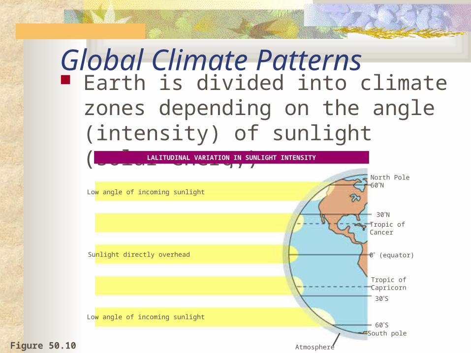
Global Climate Patterns Earth is divided into climate zones
depending on the angle (intensity) of sunlight (solar energy)
Figure 50.10
Low angle of incoming sunlight
Sunlight directly overhead
Low angle of incoming sunlight
North Pole60N
30NTropic ofCancer
0 (equator)
30S
60S
Atmosphere
LALITUDINAL VARIATION IN SUNLIGHT INTENSITY
Tropic ofCapricorn
South pole

Figure 50.10
June solstice: NorthernHemisphere tilts toward sun; summer begins in Northern Hemisphere; winter begins inSouthern Hemisphere.
March equinox: Equator faces sun directly;neither pole tilts toward sun; all regions on Earthexperience 12 hours of daylight and 12 hours ofdarkness.
60N30N
0 (equator)
30S
Constant tiltof 23.5
September equinox: Equator faces sun directly; neither pole tilts toward sun; all regions on Earth experience 12 hours ofdaylight and 12 hours of darkness.
December solstice: NorthernHemisphere tilts away from sun; winter begins in Northern Hemisphere; summer begins in Southern Hemisphere.
SEASONAL VARIATION IN SUNLIGHT INTENSITY
Seasons are the result of Earth’s tilt and the movement in space

Descendingdry airabsorbsmoisture
Ascendingmoist airreleasesmoisture
Descendingdry airabsorbsmoisture
30 23.5 0 23.5 30Aridzone Tropics
Aridzone
60N
30N
0 (equator)
30S
60S
GLOBAL AIR CIRCULATION AND PRECIPITATION PATTERNS
Air circulation and wind patterns play major parts in determining the Earth’s climate patterns and distinguish the climate zones.
Figure 50.10

GLOBAL WIND PATTERNS
Westerlies
Northeast trades
Doldrums
Southeast trades
Westerlies
AntarcticCircle
60S
30S
0(equator)
30N
60N
ArcticCircle
Figure 50.10

Landscape ecology (Biomes) Deals with arrays of ecosystems and how they
are arranged in a geographic region
Figure 50.3e
(e) Landscape ecology. To what extent do the trees lining the drainage channels in this landscape serve as corridors of dispersal for forest animals?

Portion of Earth that supports life
Biosphere

Earth’s aquatic biomes
Figure 50.15
30N
Tropic of Cancer
Equator
30S
Continentalshelf
Lakes
Coral reefs
Rivers
Oceanic pelagiczone
Estuaries
Intertidal zone
Abyssal zone(below oceanicpelagic zone)
Key
Tropic ofCapricorn

Aquatic biomes Account for the largest part of the biosphere in
terms of area Can contain fresh or salt water
Oceans Cover about 75% of Earth’s surface Have an enormous impact on the biosphere

Many aquatic biomes Are stratified into zones or layers defined by
light penetration, temperature, and depth
Marine zonation. Like lakes, the marine environment is generally classified on the basis of light penetration (photic and aphotic zones), distance from shore and water depth (intertidal, neritic, and oceanic zones), and whether it is open water (pelagic zone) or bottom (benthic and abyssal zones).
Zonation in a lake. The lake environment is generally classified on the basis of three physical criteria: light penetration (photic and aphotic zones), distance from shore and water depth (littoral and limnetic zones), and whether it is open water (pelagic zone) or bottom (benthic zone).
(a)
Littoralzone Limnetic
zone
Photiczone
Benthiczone
Aphoticzone
Pelagiczone
Intertidal zone
Neritic zone Oceanic zone
0
200 mContinentalshelf
Photic zone
Pelagic zone
Aphoticzone
Benthiczone
2,500–6,000 m
Abyssal zone(deepest regions of ocean floor)
(b)
Figure 50.16a, b

Figure 50.17An oligotrophic lake in Grand Teton, Wyoming
A eutrophic lake in Okavango
delta, Botswana
LAKES

Figure 50.17
WETLANDS
Okefenokee National Wetland Reserve in Georgia

STREAMS AND RIVERS
Figure 50.17A headwater stream in theGreat Smoky Mountains
The Mississippi River farform its headwaters

Figure 50.17 An estuary in a low coastal plain of Georgia
ESTUARIES

Figure 50.17
INTERTIDAL ZONES
Rocky intertidal zone on the Oregon coast

Figure 50.17 Open ocean off the island of Hawaii
OCEANIC PELAGIC BIOME

Figure 50.17 A coral reef in the Red Sea
CORAL REEFS

Figure 50.17 A deep-sea hydrothermal vent community
MARINE BENTHIC ZONE

Terrestrial Biomes have similar climates (temperature and rainfall) and organisms.
30N
Tropic ofCancer
Equator
Tropic ofCapricorn
30S
Key
Tropical forest
Savanna
Desert
Chaparral
Temperate grassland
Temperate broadleaf forest
Coniferous forest
Tundra
High mountains
Polar ice

Is the temperature of each Biome: Hot, moderate, or cold? Tundra - Cold Desert - Hot Temperate Grassland - Moderate Tropical savanna - Hot Taiga - Cold Temperate forest - Moderate Tropical rainforest - Hot
Tundra - Desert - Temperate Grassland - Tropical savanna - Taiga - Temperate forest - Tropical rainforest -

TROPICAL FOREST
A tropical rain forest in BorneoFigure 50.20

Figure 50.20
DESERT
The Sonoran Desert in southern Arizona

Sheyenne National Grassland in North Dakota
Figure 50.20
TEMPERATE GRASSLAND

Figure 50.20
SAVANNA
A typical savanna in Kenya

CHAPARRAL
An area of chaparral in California
Figure 50.20

Figure 50.20
Rocky Mountain National Park in Colorado
CONIFEROUS FOREST

Figure 50.20
TEMPERATE BROADLEAF FOREST
Great Smoky Mountains National Park in North Carolina

Figure 50.20
TUNDRA
Denali National Park, Alaska, in autumn