
Ch 19 Earthquakes - Weebly
32
1 Ch 19 Earthquakes During the 1906 San Francisco earthquake, this fence in Marin County was displaced by almost 5 m. The fence has moved or been displaced due to a fault. Objectives * Define stress and strain as they apply to rocks. * Distinguish among the three different fault types. * Contrast three types of seismic waves. - What are Earthquakes? - The shaking or trembling caused by the sudden release of energy - Usually associated with faulting or breaking of rocks - Continuing adjustment of position results in aftershocks Review: Lithosphere - Earth’s rigid outer shell where the vast majority of earthquakes take place. Made up of the crust and the very upper part of the mantle. - rigid: when stress is applied to a rock, it will break instead of bending.
Transcript of Ch 19 Earthquakes - Weebly

1
Ch 19 Earthquakes
During the 1906 San Francisco earthquake, this fence in Marin County was
displaced by almost 5 m. The fence has moved or been displaced due to a fault.
Objectives
* Define stress and strain as they apply to rocks.
* Distinguish among the three different fault types.
* Contrast three types of seismic waves.
- What are Earthquakes?
- The shaking or trembling caused by the sudden release of energy
- Usually associated with faulting or breaking of rocks
- Continuing adjustment of position results in aftershocks
Review: Lithosphere
- Earth’s rigid outer shell where the
vast majority of earthquakes take
place. Made up of the crust and the
very upper part of the mantle.
- rigid: when stress is applied to
a rock, it will break
instead of bending.

2
The Forces Within the Earth 19.1
- Stress: total force acting on the crustal rocks per unit of area; stress= force/area
- when stress overcomes the strength of the rock, movement occurs
- the vibrations are felt as earthquakes at the surface
- 3 kinds of stress
- tension: pulls material apart
- compression: decreases volume
- shear: causes material to twist
rocks move past one another
Strain: deformation of material in response to stress
Stress-Strain Curve: shows the
relationship between stress and strain.
Has 2 parts to it.
- Elastic deformation: rock will return to
its original shape when stress is removed.
No permanent deformation.
- Plastic deformation: rock will NOT
return to its original shape when stress is
removed. There is permanent
deformation.
- Failure: when the rock breaks;
earthquake occurs

3

4
- Fault: the resulting movement, due to failure (breaking), that occurs in the rock
- Fault plane: the surface along which fault movement takes place
- There are 3 basic types of faults that are created from stress
1) Reverse Fault: forms as a result of horizontal compression and
results in a shortening of the crust involved. One side is pushed up
relative to the other side.
2) Normal Fault: movement is both horizontal and vertical, resulting in
a lengthening of the crust involved. One side moves down relative to
the other side. The rock is stretched.

5
3) Strick-slip Fault: the fracture is caused by horizontal shear and
movement is mainly horizontal.
- What are Earthquake Waves?
- Response of material to the arrival of energy fronts released by rupture
- Waves are uniform through a homogeneous material
- Waves are not uniform through a heterogeneous material
- The earth is not uniform! Therefore, waves do not travel in
a uniform fashion. They are reflected or bent.
- Two types of waves: Body and Surface
- Body waves: two types; P and S
- P-waves (primary waves or compression waves)
- Energy moves parallel to waves
- Squeeze and pull rocks in same direction as the wave travels
- Fastest earthquake, 1st wave to reach you.
- Travel: 5-7km per second in the crust
8 km per sec in the mantle
.34km per sec in sand
- Travel through solids, liquids, or gases http://www.youtube.com/watch?v=2rYjlVPU9U4&safe=active p waves: 18 sec

6
- S-waves (secondary waves)
- Energy moves perpendicular which cause rocks to move at right
angle in relation to the direction the waves are traveling
- Travel 3-4 km per sec
- slower than p-waves
- arrive after p-wave
- S-waves move only through solids! Not liquids!
- Shear waves - move material perpendicular to wave movement http://www.youtube.com/watch?v=en4HptC0mQ4&safety_mode=true
s waves: 18 sec
https://www.youtube.com/watch?v=jsVwVlU-qMQ&spfreload=10 s wave/p wave demo 4 min

7
- Surface waves: two types, R and L; surface waves do not pass through
Earth’s interior at all.
- R-waves: (Rayleigh waves)
- particles move in an elliptical path within a vertical plane, up
and down, while the direction of the wave moves horizontal. http://www.youtube.com/watch?v=6yXgfYHAS7c&safe=active r waves: 15 sec
- L-waves: (Love waves)
- particles move material back and forth in a horizontal plane, side
to side, while the direction of the wave moves horizontal. http://www.youtube.com/watch?v=B-8H4GmSNO8&NR=1&safe=active l waves: 6 sec
- Caused when S & P waves reach the surface
- Travel just below or along the ground’s surface
- Slower than body waves; rolling and side-to-side movement
- Especially damaging to buildings; severe ground movement

8
- Generation of Seismic Waves: Focus & Epicenter
- Focus: The point within Earth where faulting begins. Earthquake
waves originate here.
- Three categories based on focus depth
- Shallow-focus earthquake: 0-70 km deep
- most destructive
- Intermediate-focus: 70-300 km deep
- Deep-focus: 300km plus
- Most are less than100km
- Epicenter: The point directly above the focus on the surface.

9
The epicenter of the magnitude 7.0 January 12, 2010,earthquake that devastated
Haiti was located approximately 25 km west-southwest of Port-au-Prince, and had
a focal depth of 13 km.
The 7.0-magnitude earthquake that struck the island nation of Haiti on January 12,
2010, destroyed its capital city, Port-au-Prince, and devastated the surrounding
areas, killing more than 222,500 people.

10
https://www.cnn.com/2021/03/04/world/new-zealand-quake-tsunami-warning-intl/index.html

11
Seismic Waves and Earth’s Interior 19.2
Objectives
* Describe how a seismometer works
* Explain how seismic waves have been used to determine the structure and
composition of the Earth’s interior.
- Seismometer/Seismograph: Instrument used to measure horizontal and vertical
motions of an earthquake. Used to record
earthquake waves.
- Modern seismographs will have the ability to measure horizontal east-west
and horizontal north-south and the vertical motion. That is three directions
of motion
Horizontal-motion seismograph http://www.youtube.com/watch?v=83GOKn7kWXM&safe
ty_mode=true&safe=active 11 sec
Because of its inertia, the suspended
mass that contains the marker remains
stationary, while the rest of the
structure moves along with the ground
during an earthquake. The marker will
record the earthquake waves on the
rotating drum. This seismograph would
record waves from west or east, but to
record waves from the north or south,
another seismograph, at right angles to
this one, is needed.
Vertical-motion seismograph http://www.youtube.com/watch?v=DX5VXGmdnAg&safet
y_mode=true&safe=active 13 sec
This seismograph operates on the same
principle as the horizontal-motion
instrument and records vertical ground
movement.

12
This seismograph records earthquakes on a strip of paper
attached to a rotating drum.
- Seismogram: a record produced by the seismometer
- can provide individual tracking of each type of seismic wave

13
- Travel-time curves (also referred to as time-distance graphs) : show how
long it takes for P-waves and S-waves to reach seismic stations.
- Graph shows the average travel times for P- and S-waves.
- The farther away a seismograph is from the focus of an earthquake,
the longer the interval between the arrivals of the P- and S- waves.
* we will use this to figure out the distance to the epicenter in section 3*

14
What is Earth’s Interior Like?
- Clues to Earth’s Interior
- behavior and travel times of P and S waves helps
define interior structure
- speed of waves is dependent on the density and
elasticity of material they travel through
- waves are bent (refracted) or bounced (reflected) as
they pass through different materials in Earth
The change in speed and direction of the waves mark the boundaries
between the different layers of the Earth!!!

15
Here is a profile showing P & S wave speeds versus depth. The changes in speed
indicate changes in Earth materials or their properties and is the basis for
subdividing Earth’s interior into concentric layers

16
- The Core
- behavior of P and S waves indicates a solid inner and liquid outer core
- inner core is iron/nickel, rotates more rapidly than outer core
- produces earth’s magnetic poles?
- outer core is iron mixed with sulfur, density of 9.9 to 12.3 gm/cm3
- 3.5 million atmospheres of pressure; approximately 52 million psi
- inner core temperature is estimated to be about 6,500°C
P-waves are refracted so that no direct P-wave energy reaches the surface in the P-wave shadow zone.
The presence of an S-wave shadow zone indicates that S-waves are being blocked within Earth
Why does this
occur?
Why does this
occur?

17
- The Mantle
- Seismic wave velocities generally increase with depth,
but several irregularities or discontinuities exist
- Sharp velocity increase in wave travel times at a
depth of about 30km - called the Moho
Seismic Discontinuity: Andrija Mohorovic´icˆ studied seismic waves and detected a seismic discontinuity at a
depth of about 30 km. The deeper, faster seismic waves arrive at seismic stations first, even though they travel
farther. This discontinuity, now known as the Moho, is between the crust and mantle.
- The Moho separates the crust from the mantle
- The low-velocity zone is inferred to represent zones of partial
melting in the asthenosphere
- 1-2% melted
- somewhat plastic
- Composition believed to be that of the igneous rock peridotite

18
Variations in P-wave velocity in the upper mantle and transition zone.
https://www.youtube.com/watch?v=aY6SG7GPAlo Earth's Interior - Seismic Evidence Explanation 14:30 min

19
- The Crust
- Continental crust
- Overall composition similar to granite
- Low density (2-3gm/cm3)
- Averages 35km thick, more under mountain ranges
- Oceanic crust
- Basalt/gabbro composition
- Higher density (3gm/cm3)
- Between 5 and 10km thick

20
Measuring and Locating Earthquakes 19.3
Objectives
* Compare and contrast earthquake magnitude and intensity and the scales used to measure each.
* Explain why data from at least three seismic stations are needed to locate an earthquake’s epicenter.
* Describe the Earth’s seismic belts.
- How is the Size and Strength of an Earthquake Measured?
- Magnitude: measure of the amount of energy released during an earthquake
- Movement Magnitude Scale: measures the energy and the size of the fault
rupture
- Richter Scale: This scale was developed in the 1930's. This scale is a rating
of the size of seismic waves measured by the seismograph. This scale
measures mostly shaking. This scale provides accurate measurements for
small, nearby earthquakes but the scale does not work well for large or
distant earthquakes. This scale is based on a logarithmic scale by 10's.
- Richter scale
measures total
amount of energy
released by an
earthquake,
independent of
intensity
- Amplitude of the
largest wave
produced by an event
is corrected for
distance and
assigned a value on a
logarithmic scale

21
- Intensity
- Mercalli Scale- This scale was developed in the early 20th century to rates the types of
damage and the intensity of an earthquake. The Mercalli scale is a 12
step scale that describes how earthquakes affect people, buildings, and
the lands surface. This scale is not a precise measurement.
- subjective measure of the kind of damage done and people’s reactions to it
- isoseismal lines identify areas of equal intensity
The Richter Magnitude
Scale measures the total
amount of energy released by
an earthquake at its source.
The magnitude is determined
by measuring the maximum
amplitude of the largest
seismic wave and marking it
on the right-hand scale. The
difference between the arrival
times of the P- and S-waves
(recorded in seconds) is
marked on the left-hand scale.
When a line is drawn between
the two points, the magnitude
of the earthquake is the point
at which the line crosses the
center scale.

22
23
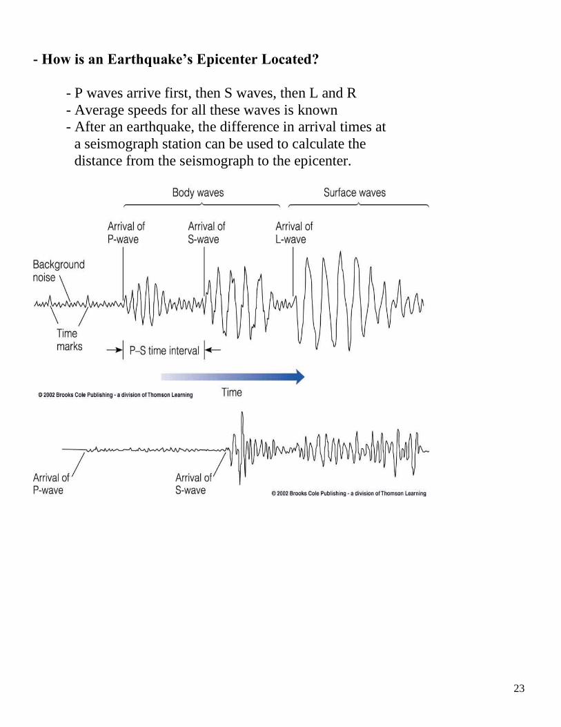
- How is an Earthquake’s Epicenter Located?
- P waves arrive first, then S waves, then L and R
- Average speeds for all these waves is known
- After an earthquake, the difference in arrival times at
a seismograph station can be used to calculate the
distance from the seismograph to the epicenter.

24
- Time-distance graph showing the average travel times for P- and S-waves. The farther away a seismograph is from the
focus of an earthquake, the longer the interval between the
arrivals of the P- and S- waves.

25
- Three seismograph stations are needed to locate the
epicenter of an earthquake
- A circle where the radius equals the distance to the
epicenter is drawn
- The intersection of the circles locates the epicenter
https://www.youtube.com/watch?v=694yaY2ylTg 4 min
https://www.youtube.com/watch?v=TBss68oBmmk
10 min 18 sec

26
Earthquakes & Society 19.4
Objectives
* Discuss factors that affect the amount of damage done by an earthquake.
* Explain some of the factors considered in earthquake probability studies.
* Define seismic gaps
- Earthquake Hazards
- Ground Shaking
- amplitude, duration, and damage increases in poorly
consolidated rocks
- structures built on weaker material typically suffer
greater damage
- Structural failure
- Fire
- Tsunami
- Ground failure
Relationship Between Seismic Wave Amplitude and
Underlying Geology: The amplitude and duration of seismic waves generally
increase as the waves pass from bedrock into poorly consolidated or water-
saturated material. Thus, structures built on weaker material typically suffer greater
damage than similar structures built on bedrock because the shaking lasts longer.

27
Liquefaction: The effects of ground shaking on water saturated soil are
dramatically illustrated by the collapse of these buildings in Niigata, Japan, during
a 1964 earthquake. The buildings were designed to be earthquake resistant and fell
over on their sides intact when the ground below them underwent liquefaction.
Some of the useful things a homeowner can do to reduce damage to a building because of ground shaking
during an earthquake. Notice that the structure must be solidly attached to its foundation and bracing the walls
helps prevent damage from horizontal motion.

28
During the 2008 Sichuan, China earthquake, structures of masonry construction, coupled with little or no
reinforcing collapsed, leading to tremendous damage and loss of life.

29
http://www.youtube.com/watch?v=tF204Pgf-eo&safety_mode=true&safe=active
eathquake proof: 2:22 min
http://www.youtube.com/watch?v=IjPiujuF0TA&safety_mode=true&safe=active Smart earthquake protection with vibration control: 1:06 min
http://www.youtube.com/watch?v=ChaqMDc4ces&safety_mode=true&safe=active Earthquake Protective Foundation - base isolation video: 27 sec
http://www.youtube.com/watch?v=xp2pGxFzrzI&NR=1&feature=endscreen&safety_mode=true Dampers for earthquake protection: 30 sec

30
- Can Earthquakes be Predicted?
- Earthquake Precursors
- changes in elevation or tilting of land surface,
fluctuations in groundwater levels, magnetic field,
electrical resistance of the ground
- seismic dilatancy model
- based on changes in rock when subjected to high
pressure; increase in volume
- seismic gaps: areas of prior earthquake activity
- Earthquake Prediction Programs
- include laboratory and field studies of rocks before,
during, and after earthquakes
- monitor activity along major faults
- produce risk assessments

31
Global Seismic Hazard Assessment Map The Global Seismic Hazard Assessment
Program published this seismic hazard map showing peak ground accelerations.
The values are based on a 90% probability that the indicated horizontal ground
acceleration during an earthquake is not likely to be exceeded in 50 years. The
higher the number, the greater the hazard. As expected, the greatest seismic risks
are in the circum-Pacific belt and the Mediterranean–Asiatic belt.
Geologists examine a trench
across an active fault in
California to determine possible
seismic hazards. Excavating
trenches is a common method
used by geologists to gather
information about ancient
earthquakes in a region and to
help assess the potential for
future earthquakes and the
damage that they might cause.

32
- Can Earthquakes be Controlled?
- Graph showing the relationship between the amount of
waste injected into wells per month and the average number
of Denver earthquakes per month
- Some have suggested that pumping fluids into seismic gaps
will cause small earthquakes while preventing large ones