CEOS Acquisition Strategy for GEOGLAM Phase 1
37
CEOS ACQUISITION STRATEGY FOR GEOGLAM PHASE 1 Version 1.0 - November 2013
Transcript of CEOS Acquisition Strategy for GEOGLAM Phase 1
CEOS ACQUISITION STRATEGY FOR GEOGLAM PHASE 1
Version 1.0 - November 2013

Table of Contents
Executive Summary .............................................................................................................................. 2 1 Introduction ..................................................................................................................................... 4
1.1 Purpose of the Document........................................................................................................... 4 1.2 Scope ......................................................................................................................................... 4 1.3 Contents ..................................................................................................................................... 4
2 GEOGLAM ..................................................................................................................................... 6 2.1 Overview ................................................................................................................................... 6 2.2 JECAM ...................................................................................................................................... 6 2.3 Support to the Agricultural Market Information System (AMIS) ............................................. 7 2.4 Asia-RiCE .................................................................................................................................. 7 2.5 GEOGLAM and CEOS Phasing ................................................................................................ 7
3 Requirements ................................................................................................................................. 10 3.1 Target Product Specifications .................................................................................................. 10 3.2 Satellite Observation Requirements for Target Products ........................................................ 11 3.3 Spatial and Temporal Coverage ............................................................................................... 12 3.4 Sampling Strategy Development Support ............................................................................... 15
4 Acquisition Strategy ...................................................................................................................... 17 4.1 Basic Strategy for GEOGLAM Phase 1 .................................................................................. 17 4.2 Data Streams ............................................................................................................................ 17 4.3 Individual Roles of the Data Streams ...................................................................................... 19
5 Implementation ............................................................................................................................. 21 5.1 Introduction and Overview ...................................................................................................... 21 5.2 Primary Data Stream Implementation Actions ........................................................................ 21 5.3 Secondary Data Stream Implementation Actions .................................................................... 21 5.4 Potential Data Stream Implementation Actions ....................................................................... 22
6 Next Steps ...................................................................................................................................... 23 Appendix A: JECAM Test Sites ......................................................................................................... 24 Appendix B: Detailed Cropland Growing Seasons and Maps ........................................................ 26 Appendix C: Summary of GEOGLAM Data Streams .................................................................... 29 Appendix D: Data Stream Detailed Agency Implementation Requests ......................................... 30 Appendix E: Assessment of Landsat Cloud Cover ........................................................................... 33 Appendix F: Spatially-Temporally Explicit Data Package ............................................................. 36
i
Page i
Executive Summary The Group on Earth Observations (GEO) Global Agricultural Monitoring (GEOGLAM) initiative aims to support agricultural production estimates through the use of Earth observations. It was developed in response to the G20 Agricultural Ministers’ concern about market volatility for the world’s major crops. The initiative’s goal is to strengthen the international community’s capacity to produce and disseminate relevant, timely and accurate forecasts of agricultural production at national, regional and global scales through the use of Earth observations. GEOGLAM data outputs will directly support the Agricultural Market Information System (AMIS), a partner initiative launched by the G20 Agricultural Ministers and endorsed by the G20 heads of states. The R&D component of GEOGLAM, called JECAM (Joint Experiment for Crop Assessment and Monitoring), has been operating since 2011, with support from the Committee on Earth Observation Satellites (CEOS).
In July 2013, the GEOGLAM Implementation Plan was approved by GEO Executive Committee, proposing four phases developed in consultation with CEOS. This Strategy outlines the CEOS response to the Implementation Plan, covering Phase 1 (2013-2015). Phase 1 focuses on existing and foundation activities, pilot projects, and scoping of future phases.
The Phase 1 Strategy considers the satellite observations required as three data streams:
- Primary (expected to best meet the requirements, in most cases freely available): MODIS, Landsat-7/8, RADARSAT-2, Sentinel-1, GCOM-W, RapidEye;
- Secondary (used for evaluation in the event the primary data stream is not available): Suomi-NPP, Proba-V, SMOS, SPOT-5, Resourcesat-2, TerraSAR-X; and
- Potential (in the early stages of consideration and likely to be assessed in future GEOGLAM phases): SMAP, Sentinel-2, Sentinel-3, Pleiades-1, ALOS-2, CBERS-3.
Data acquired from these missions will support the development of a range of target products. These products imply a wide range of spatial and temporal coverage by satellites, from monthly (for moderate resolution coverage such as Landsat) through daily (for MODIS and GCOM-W). The Strategy defines acquisitions by relevant CEOS agency missions to support the target products and GEOGLAM Implementation Plan during 2013-2015 - with a coverage area of approximately 1.3 million km2 over 20 countries. The strategy is:
− to address the minimum space data provision necessary for GEOGLAM Phase 1 countries to engage in crop forecasting activities;
− as agency data policy allows, provide access to the resulting data archives by countries for national agricultural forecast information systems;
− to respond to the current GEOGLAM Implementation Plan, but anticipate future phases, and the launch of additional satellites within the next few years which will improve CEOS capacity and the prospects for support; and
− to adapt to changes in requirements, and to space agency supply plans; further revisions and editions (e.g. GEOGLAM Phase 2) of the CEOS Acquisition Strategy should serve as the basis for on-going communication with, and coordination of, the CEOS agencies in support of GEOGLAM.
Noting the existing significant commitments of many of the same CEOS agencies and missions in support of GEO’s Global Forest Observations Initiative (GFOI), the GEOGLAM
2
Page 2

acquisition strategy will be harmonised as far as possible with the equivalent CEOS strategy for GFOI, to ensure maximum efficiency in data acquisitions.
3

1 Introduction
1.1 Purpose of the Document The purpose of this document is to define how space agencies from the Committee on Earth Observing Satellites (CEOS) will coordinate their relevant Earth observing satellite systems to acquire data to support information requirements arising from the Phase 1 of the Group on Earth Observation’s (GEO) Global Agricultural Monitoring initiative (GEOGLAM). The document has been prepared by the CEOS Ad-hoc Working Group on GEOGLAM and the primary audience is the CEOS community.
1.2 Scope This document focuses on CEOS support for Phase 1 of GEOGLAM, which according to the GEOGLAM Implementation Plan (GEOGLAM IP), “…focuses on foundation activities, building on existing activities and pilot projects for a few countries, and scoping out the programme for the following phases”. CEOS support to Phase 1 of the GEOGLAM IP covers acquisitions over 2013-2015. Four phases are foreseen through to the start of a global, operational monitoring capability for GEOGLAM in 2017.
The Ad-hoc Working Group concluded that a phased approach was essential for the CEOS support to GEOGLAM for a number of compelling reasons:
− The institutional framework for GEOGLAM remains a work in progress and confidence in a sustained future for the initiative can develop as capacity is seen to grow in the Project Office and elsewhere, with CEOS seeing demonstrable capability to manage and exploit the significant volumes of space data being requested for acquisition;
− GEOGLAM is the second global initiative in recent years requiring significant satellite observations of the land surface (following GFOI, the Global Forest Observations Initiative) and CEOS and its agencies will need to find a way forward that ensures efficiencies in the acquisition, processing and distribution of the data;
− Current capacity to support major land surface imaging acquisition programmes with freely available satellite data streams is limited to the Landsat series; but the launch of a number of important missions is anticipated in the coming two years – which should support an expansion of ambitions for significant data acquisitions of the kind envisioned for later phases of GEOGLAM; and
− There is a need to develop, review, share and operationalize monitoring techniques and to validate the results in a stepwise fashion.
1.3 Contents Section 2 provides more background on GEOGLAM and its precursor the Joint Experiment for Crop Assessment and Monitoring (JECAM).
Section 3 defines the requirements communicated by GEOGLAM that determine the approach to a supporting space data acquisition strategy. It includes target product specifications, satellite observation requirements, and temporal and spatial sampling needs.
Section 4 describes how CEOS agencies will implement the strategy and identifies the contribution of individual agencies and satellites.
Section 5 proposes the next steps for CEOS in relation to its support for GEOGLAM.
4

Appendices A-F include additional information on JECAM Test Sites (A), cropland growing seasons (B), GEOGLAM data streams (C), detailed data stream implementation requests (D), Landsat cloud cover assessment (E), and on a spatially-temporally supporting data package (F).
5

2 GEOGLAM
2.1 Overview GEOGLAM aims to enhance agricultural production estimates through the use of Earth observations, and to address concerns about market volatility for the world’s major crops raised by the G20 Agricultural Ministers. It hopes to strengthen the international community’s capacity to produce and disseminate relevant, timely and accurate forecasts of agricultural production at national, regional and global scales through the use of Earth observations.
The GEOGLAM Work Plan outlines six components that makeup GEOGLAM:
1) Enhancing global agricultural production monitoring systems; 2) Building capacity at the national level to utilize Earth observations; 3) Supporting monitoring of countries at risk to improve food security; 4) Improving coordination of Earth observations for agricultural monitoring; 5) Coordinating R&D in support of improved operational agricultural monitoring; and 6) Disseminating data, products and information.
As noted in Section 1.2, a phased approach to GEOGLAM is proposed, with the GEOGLAM Task Team developing an Implementation Plan for Phases 1 and 2, which was endorsed by the GEO Executive Committee in July 2013. This Plan calls for CEOS to contribute to Components 1, 4 and 5 of the GEOGLAM Work Plan.
Component 1 – coordinating space data support for Asia-RiCE (see Section 2.4).
Component 4 – coordination, as the space arm of GEO, increased use of Earth observations to improve operational agricultural monitoring.
Component 5 – coordinating continuing support to GEOGLAM R&D efforts through JECAM (see Section 2.2).
2.2 JECAM JECAM provides the foundation for the research and development towards operational monitoring enhancements for GEOGLAM. CEOS has been providing support to Component 5 of the GEOGLAM Work Plan through JECAM since 2011. The EO data that has been provided to date by the JECAM test sites through early 2013 is shown in Appendix A.
The overarching purpose of JECAM is to compare data and methods for crop area, crop condition monitoring and yield estimation, with the aim of establishing ‘best practices’ for different agricultural systems. The goal of the JECAM experiments is to facilitate the inter-comparison of monitoring and modelling methods, product accuracy assessments, data fusion, and product integration for agricultural monitoring. These international shared experiments are being undertaken at a series of sites which represent many of the world’s main cropping systems. The approach is to collect and share science and data, including: i) time-series datasets from a variety of Earth observing satellites useful for agricultural monitoring, and ii) in-situ crop and meteorological measurements for each site. Additional information is available from the JECAM website (JECAM.org).
Synthesis of the results from JECAM will enable the following outcomes:
− Development of international standards for agricultural monitoring and reporting protocols;
6

− A convergence of the approaches to define best monitoring practices for different agricultural systems; and
− Identification of requirements for future EO systems for agricultural monitoring.
The JECAM sites are looking at a common range of monitoring needs over a very diverse range of landscape conditions and cropping systems, including:
− Crop identification and acreage estimation;
− Yield prediction;
− Near Real Time Crop condition / Crop stress;
− Land management; and
− Soil moisture.
There are currently 24 JECAM sites in the countries shown in Appendix A. Some of these are brand new in 2013, others have been producing results since 2011, and others are dormant. There is already significant bi-lateral collaboration between JECAM sites planned and underway. Use of the site network to support research external to JECAM is already taking place.
Requirements for JECAM, while continuing to be supported by ongoing CEOS activities, are not explicitly addressed in the CEOS Acquisition Strategy for GEOGLAM Phase 1. It is expected that in subsequent phases, the JECAM data requirements may in fact grow together, or be blended or further harmonized with the mainline GEOGLAM requirements.
2.3 Support to the Agricultural Market Information System (AMIS) The GEOGLAM IP calls for direct support to the AMIS, a partner initiative launched by the G20 Agricultural Ministers and endorsed by the G20 head of states and a key beneficiary of the GEOGLAM outputs.
As of August 2013, GEOGLAM has started to provide monthly crop outlook reports to AMIS. These products are derived from a number of observations, including satellite data contributions from CEOS agencies which are inputs into satellite derived agro-meteorological information such as NDVI anomaly, water stress, soil moisture, land surface temperature, and accumulated rainfall.
2.4 Asia-RiCE A group for coordination of observations for Asian rice crops known as Asia-RiCE (Asian Rice Crop Estimation, Monitoring, and Outlook) was created under the leadership of JAXA and ISRO in support of GEOGLAM. The Asia-RiCE initiative has been organised to develop the rice crop monitoring component of the GEOGLAM initiative. This group has been focused on defining observational requirements, working with a number of Asian countries to define Technical Demonstration sites, and supporting them in securing the required flow of data. The Asia-RiCE group has provided significant inputs to both the Phase 1 Strategy, as well as the GEOGLAM IP.
2.5 GEOGLAM and CEOS Phasing The GEOGLAM IP has proposed a phased approach in order to:
− Allow JECAM to develop, review, share and operationalize monitoring techniques;
7

− Allow countries time to build capacity to collect and process EO data, and incorporate the results into their management and decision making;
− Pilot and iterate observational sampling approaches; and − Allow time to validate the results in a stepwise fashion.
The phased implementation across all components will have four phases through 2017 (see Figure 1).
− Phase 1 (P1), spans over the 2012-2014 time frame, focuses on foundation activities, building on existing activities and pilot projects for a few countries, and scoping out the programme for the following phases;
− Phase 2 (P2) will review and expand P1 activities with new starts and will be carried out during the 2014-2016 period;
− Phase 3 (P3) will be the last building pre-operational one with the completion of P1/P2 projects and geographical expansion, going from 2015 to 2017 when the Operational Phase starts;
− Phase 4 (P4), the operational phase, starts at the end of 2017.
This phased approach was developed in consultation with CEOS, and agreed in principle at the Data Acquisition Planning meeting hosted by CEOS in November 2012. This approach enables an evolution of GEOGLAM capacity along several parameters:
− Increasing the number of countries, including further at-risk countries; − Integrating of additional new sensors as they become available (e.g. Sentinel-1, Sentinel-2,
etc.); − Developing sampling strategies that reduce and/or optimise product generation inputs
and process; − Assimilating, processing, product creation, distribution and integration of additional
information products into decision making processes; and − Building capacity, particularly in at-risk countries for ingestion and processing of EO data.
Figure 1 The GEOGLAM Phased Implementation Calendar (Figure 3 from the GEOGLAM IP July 2013)
CEOS Phasing: The Ad-hoc Working Group has further divided the 1st Phase of GEOGLAM, to consider it as comprising two parts – Phase 1A and Phase 1B. Phase 1A acquisitions have already commenced, supported by amenable agencies (USGS, CSA, ESA), and targets coverage of the Southern Hemisphere 2013 growing seasons in Australia and Argentina (April 2013 – August 2014), as well as four Asia-RiCE Technical Demonstration Sites (September 2013 onwards). Phase 1B begins with the 2014 Northern Hemisphere growing season, starting in approximately March 2014, includes the Phase 1A areas plus a number of additional areas,
8

and continues until the end of 2015. CEOS support for Phase 1 extends into 2015 in order to accommodate the growing seasons of Southern Hemisphere and Asia-RiCE crops commencing in late 2014. The coverage areas are summarised in Table 2.
Phase Region Crop Scale Area[1] Approx. [ha]
P1A / P1B Argentina Soybeans Cropland Extent 10.3M P1A / P1B Australia Wheat Cropland Extent 19.4M P1A / P1B Thailand Rice P1A Sample
P1B Wall-to-Wall 13.8M[2]
P1A / P1B Indonesia Rice Sample 17.4M[2] P1A / P1B Vietnam
North Rice Sample
8.8M[2] P1A / P1B Vietnam South
Rice Sample
P1B Russia Wheat / Corn Cropland Extent 36.9M P1B Ukraine Wheat Cropland Extent 14.4M P1B Uganda Multiple Cropland Extent 1.7M P1B Tanzania Multiple Cropland Extent 6.1M P1B Algeria Multiple Cropland Extent 3.0M P1B Ethiopia Multiple Cropland Extent 9.5M P1B Pakistan Wheat /
Multiple Cropland Extent 13.0M
P1B Japan Rice Sample 1.9M [2] P1B Lao Rice Sample 1.1M [2] P1B China Rice Sample 92.6M [2] P1B India Rice Sample 97.0M [2] P1B Malaysia Rice Sample 0.7M [2] P1B Taiwan Rice Sample N/A [2] P1B Philippines Rice Sample 7.2M [2]
Table 1 GEOGLAM Phase 1A and 1B Coverage Summary
[1] Land under cereal production (hectares) 2008-2012, http://data.worldbank.org/indicator/AG.LND.CREL.HA/countries
[2] Asia-Rice Technical Demonstration Sites are approximately 100 x 100 km for GEOGLAM Phase 1, with the exception of Thailand which calls for national wall-to-wall coverage for Phase 1B.
The coverage area proposed for Phase 1 includes 20 countries, and total crop lands of approximately 1.3 million km2. Note that while Table 2 shows the total crop area for Asia-RiCE countries, all rice areas except Thailand in Phase 1B will be 100 x 100 km sample sites. (See Table 2 note [2] for more information.)
The Asia-RiCE Technical Demonstrators will utilise sample sites to provide a proof of concept on a provincial level, with the exception of Thailand, which requires wall-to-wall coverage in Phase 1B. Other non-Rice regions require coverage of cropland extent. Section 3.3 includes further detail regarding the spatial and temporal nature of regions.
9

3 Requirements
3.1 Target Product Specifications The GEOGLAM Task Team has defined a number of thematic crop information product specifications including multi-annual, annual, near real-time/weekly products. These products serve as inputs to crop forecast modelling systems such as the AMIS. A number of these products are to be produced in-season, and therefore near real time data distribution is required. A note on latency appears in Section 3.3.
Note that the requirement numbers referenced below are linked to Table 3 in Section 3.2.
Cropland Mask: A generalized map of cultivated areas, to be updated every 1 to 3 years, at Landsat scale. Finer resolution (requirements #7 - #11) may be required for smaller at-risk countries. This product requires monthly observations of cropland extent and regional Rice crop samples to enable differentiation between croplands and non-cropped lands. Monthly cloud-free Landsat scenes (minimum 2 out of season, 3 in season) are needed (requirements #4 and #5) at least every 3 years, ideally annually. In persistently cloudy areas, there will be a need to integrate additional optical and/or radar data. For example, Asia-RICE regions will utilise MODIS-class imagery (requirement #2), and will also investigate the utility of SAR imagery (requirement #6) to produce yearly cultivated rice area.
Crop Type Area and Crop Calendar: Annual derived cropland area estimates and crop calendars based on monthly observations over cropland extent (requirement #4), and weekly observations over cropland samples (requirement #5). For Asia-RiCE regions, MODIS-class (requirement #2) will be used, with monthly observations using SAR (requirement #6) for this product being investigated in future. Observations should be optimized for periods where crop types can be differentiated from each other. Overall, there is a need for 4 to 6 cloud-free observations during the growing season of one crop cycle (i.e., Argentina has 2 soy crops within the same year so additional observations are needed). In addition to Landsat data, fine resolution data (e.g RapidEye) are needed monthly (requirements #7 - #11) in order to calibrate the Landsat derived area estimates.
Crop Condition: The health and growing condition of croplands based on coarse resolution data (e.g. MODIS, SAR or microwave) for the detection of disease, flooding or droughts. Daily (requirement #1) to near-daily (requirement #2) observations will yield parameters including NDVI, LAI, FPAR, VHI, TCI, ET, precipitation, LST and Soil Moisture (microwave, requirement #3). Multi-year time series fine resolution (requirement #8) and moderate resolution (requirements #5 and #6) are used for anomaly comparisons. In addition, this product requires integration with ground observations (e.g. crop production statistics).
Crop Yield: Derived cropland output (yield) is based on empirical information and crop growth information (e.g. NDVI, LAI, FAPAR, LST) from near-daily coarse resolution observations (requirement #2) and microwave measurements of precipitation, temperature and ET (requirement #3). While still in the research phase, in future biomass estimation using SAR will be considered. In addition, this product requires integration with ground observations (i.e., crop production statistics).
Crop Biophysical Variables: Crop variables (e.g. LAI, NPP, Nitrogen content, Chlorophyll content, Water content) from various resolution observations (requirements #1 - #3, #5, #6, and #8). In addition, this product requires integration with ground observations for calibration and validation.
10

Environmental Variables: Environment variables (e.g. soil type, soil moisture) from microwave, and moderate and fine resolution observations (requirements #3, #5, #6, and #8).
Agricultural Practices / Cropping Systems: Derived cropland products (i.e., field size, number of cropping cycles per season, diversity of crops) from all types of observations (i.e. coarse, moderate, fine and very fine) resolution observations (requirements #2, #4 - #6, #8, #10, and #11).
3.2 Satellite Observation Requirements for Target Products
Table 3 summarises the satellite observations required to support the generation of the target products defined in Section 3.1. This includes the required spatial resolution, spectral range, effective observation frequency, and sample type for each product. 11 requirements have been defined in support of the target products.
Table 2 GEOGLAM Phase 1 Satellite Observational Requirements for Target Products Field size variation: small (S ~ <2.5 ha), medium (M = ~2.5 ha-15 ha), and large (L = ~ >15ha)
* Cloud free < 10% average cloud cover across the scene.
Additional notes on Table 3:
− ‘X’ indicates data required for all field sizes − Data should be made available near-real time, particularly for within season assessments;
11
− Spatial resolution requirements are generated relative to field size; this is preliminary and could be refined/improved with a consideration of landscape heterogeneity and spatial pattern;
− Meteorological parameters (snow cover, temp., rainfall, etc.) are not included in this table and will be addressed in another forum; and
− Samples need to be coordinated and nested.
In order to try and ease the requirement on cropland extent coverage for fine and moderate resolution data streams, a sampling strategy (described in Section 3.4) has been proposed. This sampling strategy means that requirement #4 calls for coverage a minimum of every 1-3 years. While the sampling strategy is expected to be able to mitigate coverage gaps, the derived products are a less accurate estimate. Annual coverage of requirement #4 will optimise the quality of the end products, and is therefore desired.
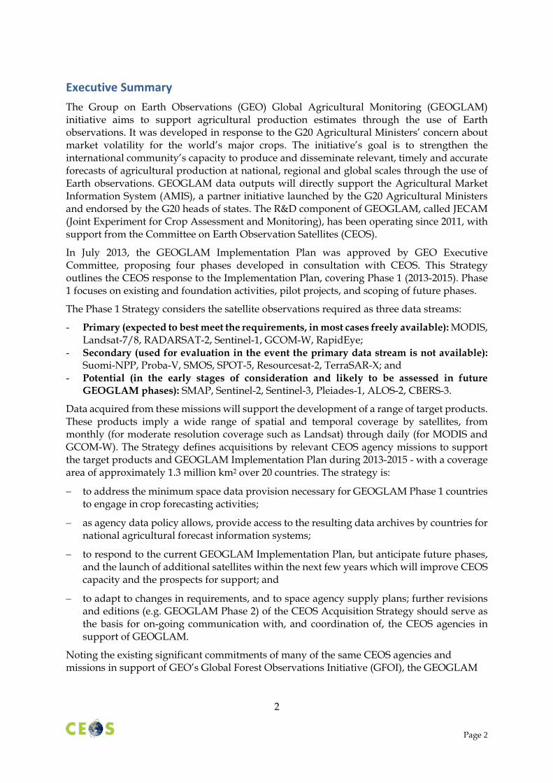
Several different sample types are referred to in Table 4, ranging from national wall-to-wall, cropland extent, sampling, and refined sampling.
Sample Type Description Wall-to-Wall National border to border coverage. Cropland Extent Border to border coverage of national
cropland regions. Sampling (s) 40 x 40 km blocks (for RapidEye) Refined Sampling (rs) A sub-set of the sampling blocks will be
chosen for refined sampling.
Table 3 Satellite Acquisition Sample Types
3.3 Spatial and Temporal Coverage
Spatial Coverage: Large Scale Regions and Technical Demonstrator Sites
As discussed in Section 2.5, spatial coverage for GEOGLAM Phase 1A consists of national cropland extent coverage for Argentinian and Australian wheat crops, Thailand wall-to-wall, and sample site coverage for five Asian rice producing regions.
Figure 2 summarizes the Phase-1A large-scale region coverage of Argentina and Australia. Appendix B includes detailed cropland extent for these countries.
12

Figure 2 GEOGLAM Phase-1A Coverage
Figure 3 summarizes the Phase-1B large-scale coverage of additional countries, listed in Table 2.
Figure 3 GEOGLAM Phase 1B Coverage
Phase 1B includes Wall-to-Wall coverage of Thailand for Asia-RiCE
Figure 4 summarise the Asian rice crop sample regions for GEOGLAM Phase 1A and 1B, respectively.
13

Figure 4 GEOGLAM Phase 1A (left) and Phase 1B (right) rice sampling regions
The CEOS Systems Engineering Office (SEO), in cooperation with the GEOGLAM Task Team and the Asia-RiCE team has produced a set of spatially-temporally explicit products (e.g. KML and shape files) in support of CEOS agency mission planning teams preparing for the implementation of the CEOS Acquisition Strategy for GEOGLAM Phase 1. These files can be found on the CEOS website (www.ceos.org) under CEOS Systems Engineering Office GEOGLAM. (See Appendix F)
Temporal Coverage: Agricultural Growing Season Calendars
Figure 5 summarises the median values for the start and end of the crop growing seasons for GEOGLAM Phase 1A (i.e. Argentina and Australia). Detailed maps of the growing seasons are provided in Appendix B.
Figure 5 Australia and Argentina Growing Seasons for Phase 1A and 1B (2013-2015)
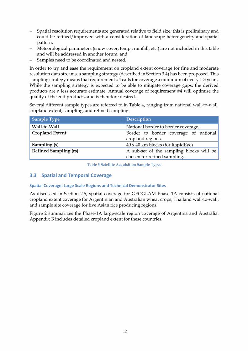
Figure 6 summarises the rice crop growing cycles for the Asia-RiCE Technical Demonstration sites to be covered during GEOGLAM Phase 1A. The typical growth cycle for Asian rice crops is 85-150 days. During a typical 120 day growth cycle, 4-5 satellite observations are required
14
in order to achieve all monitoring objectives. These observations should be evenly spaced across the growing season.
Figure 6 Asian Region Growing Seasons for Phase 1A and 1B (2013-2015)
Note: For Phase 1B, Thailand coverage expands from the sample site to national wall-to-wall.
Figures 5 and 6 are a summary of more detailed growing season information developed in support of the development of this strategy. Further detail can be found in Appendix B, as well as in the spatially-temporally explicit file package outlined in Appendix F.
Further details on the growing seasons for Phase 1B will be provided by the CEOS SEO in the file package outlined in Appendix F.
Latency
As mentioned in Section 3.1, to support in-season analyses, the data will be required to be made available near real-time.
3.4 Sampling Strategy Development Support In support of efforts to scale GEOGLAM to global operations, the development of sampling strategies is included from Phase 1. The objective of these sampling strategies is to reduce the need for frequent cropland extent acquisitions by employing small-scale sample blocks of approximately 40 x 40 km within croplands. Data from these sample blocks will be used to evaluate effective methods for product calibration and validation, and to scale up products such as crop area estimates. It is possible that a national sampling strategy can reduce the moderate spatial resolution (e.g. Landsat) cropland extent acquisition frequency requirements.
15
However, it should be noted that when feasible, cropland extent multi-temporal moderate spatial resolution observations are preferred.
For GEOGLAM Phase 1, Argentinian soy and wheat, and Australian wheat crop sampling strategies coupling RapidEye (6.5 m VIS-NIR) to Landsat (30 m VIS-SWIR) are being investigated with the aim of demonstrating that RapidEye-class sampling can reduce wall-to-wall fine to moderate spatial resolution coverage requirements for data inputs to a selection of the target products defined in Section 3.1. Based on the results from Phase 1, future phases of GEOGLAM will consider the development of multi-sensor sampling strategies in order to fully leverage all available data streams.
While current sampling strategies for Argentina and Australia are not optimised from the satellite acquisitions perspective, the team developing the sampling strategies is aware of the need to take satellite acquisition planning into account in order to realise the greatest efficiency in the long term. As the design of the sampling strategies requires the balancing of a number of factors, including statistical constraints and crop type distribution, it is acknowledged that satellite acquisition planning considerations should be integrated during the sampling design development.
Argentinian and Australian Sampling Strategies
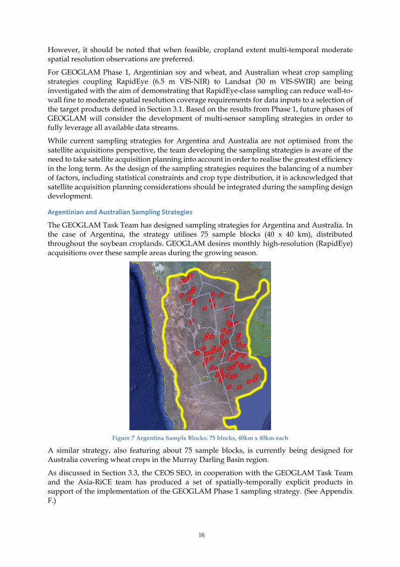
The GEOGLAM Task Team has designed sampling strategies for Argentina and Australia. In the case of Argentina, the strategy utilises 75 sample blocks (40 x 40 km), distributed throughout the soybean croplands. GEOGLAM desires monthly high-resolution (RapidEye) acquisitions over these sample areas during the growing season.
Figure 7 Argentina Sample Blocks: 75 blocks, 40km x 40km each
A similar strategy, also featuring about 75 sample blocks, is currently being designed for Australia covering wheat crops in the Murray Darling Basin region.
As discussed in Section 3.3, the CEOS SEO, in cooperation with the GEOGLAM Task Team and the Asia-RiCE team has produced a set of spatially-temporally explicit products in support of the implementation of the GEOGLAM Phase 1 sampling strategy. (See Appendix F.)
16

4 Acquisition Strategy
4.1 Basic Strategy for GEOGLAM Phase 1 The CEOS Acquisition Strategy for GEOGLAM Phase 1 may be characterised as:
− aiming to address the minimum space data provision necessary for GEOGLAM Phase 1 countries to engage in crop forecasting activities;
− based on acquisitions from a number of data streams – as agency data policy allows, provide access to the resulting data archives by countries for national agricultural forecast information systems;
− responding to the current GEOGLAM Implementation Plan, but anticipating future phases, and the launch of additional satellites within the next few years which will improve CEOS capacity and the prospects for support to future GEOGLAM phases; and
− adaptive to changes in requirements, and to space agency supply plans; further revisions and editions (e.g. GEOGLAM Phase 2) of the CEOS Acquisition Strategy should serve as the basis for on-going communication with, and coordination of, the CEOS agencies in support of GEOGLAM.
The Strategy focuses on the 2013-2015 timeframe, consistent with the objectives of supporting the development of GEOGLAM, while also allowing the opportunity to assess GEOGLAM development and evolving data requirements before defining and committing to potential CEOS support for future phases.
The geographic extent of Phase 1 support is limited to the 20 countries listed in Table 2 in order to ensure the coverage area (approximately 1.3 million km2) remains manageable. This acknowledges the need for GEOGLAM to demonstrate activities at scale, while also recognising that it is still in its formative stages, and does not yet have the capacity to support a global program.
The Strategy identifies Primary, Secondary, and Potential data streams to support implementation, with the aim of communicating the prospective roles of the data providers. These data streams are characterised by their data access policy, maturity and availability, and their fitness to support the generation of the target products specified by the GEOGLAM Task Team.
4.2 Data Streams Discussions between CEOS agencies active within the JECAM task, and the GEOGLAM Task Team have resulted in consensus on a working list of CEOS agency satellite missions that represent the candidate GEOGLAM data streams. These data streams fall into one of three categories: Primary, Secondary or Potential.
Primary data streams are the source of data that is expected to best meet the requirements. In most cases these data are freely available, but in some cases (e.g. RapidEye) these datasets may require a fee or special negotiation with an agency or commercial partner. GEOGLAM would like to pursue free and open access to all Primary datasets for its development Phases (1, 2, and 3) with the intention of securing funding for these data for long-term operational use should needs warrant.
Secondary data streams are the source of data that would be used for evaluation in the event the Primary data stream is not available. It is possible that evaluation of Secondary data will result in improved results such that a Secondary data source may be considered as a Primary
17

dataset in the future. GEOGLAM would like to pursue free and open access to all Secondary datasets for its development Phases (1, 2, and 3) with the intention of securing funding for these data for long-term operational use should needs warrant.
Potential data streams are in the early stages of consideration and will likely be assessed in future GEOGLAM development Phases (2 or 3). Should it be determined these datasets meet requirements and are available to the GEOGLAM team, they may be considered as Primary or Secondary data in the future – including during the course of Phase 1.
Table 5 shows how the GEOGLAM Phase 1 Primary, Secondary and Potential data streams relate to the target product requirements defined in Section 3.2.
Table 4 GEOGLAM Phase 1 Target Product Observational Requirements Primary and Secondary Data
Streams
18

A summary of all data streams relevant to the GEOGLAM data strategy, including a summary of data policies and measurement capabilities, can be found in Appendix C.
4.3 Individual Roles of the Data Streams The requirements outlined in Section 3.2 can be addressed by a combination of data streams from four basic instrument classes: coarse, moderate, fine and very fine resolution data streams.
Coarse Resolution: > 100m
MODIS will be the main workhorse for coarse resolution optical, thermal IR, and SWIR during GEOGLAM Phase 1. There are known continuity concerns, with Terra and Aqua operating well past their end of design life, and so secondary continuity options such as Suomi-NPP, and VEGETATION on SPOT-5 and Proba-V will also be evaluated.
GCOM-W will provide the required microwave data stream, with SMOS as a secondary option, and SMAP a potential future option.
MODIS (Terra and Aqua) Requirements #1 and #2
Standard products utilised at a daily frequency over the cropland extent to provide optical, thermal IR, and SWIR data streams.
GCOM-W Requirement #3
Utilised at a daily frequency over the cropland extent to provide a microwave data stream.
Secondary Suomi-NPP, SPOT-5, Proba-V, SMOS (microwave)
Potential Sentinel-3, SMAP (microwave)
Table 5 GEOGLAM Phase 1 Coarse Resolution (>100m) Data Streams
Moderate Resolution: 10 to 100m
It is expected that Landsat, along with the Sentinel-2 satellites (once operational), will be the optical workhorses of GEOGLAM, providing moderate resolution coverage on a global scale. Landsat is available for GEOGLAM Phase 1, while Sentinel-2A (currently planned for launch late 2014) may be available at the closing stages of Phase 1 depending on the completion of mission checkout activities. RESOURCESAT-2 represents a secondary optical source which could be evaluated if the data are available. The requirement for annual crop extent optical data is potentially reduced by plans to employ a sampling strategy, described in Section 3.4.
RADARSAT-2 and Sentinel-1 (currently planned for launch in the first half of 2014) will be the radar (C-band) workhorses for GEOGLAM Phase 1, providing coverage of the Asia-RiCE Technical Demonstration sites. (And wall-to-wall in Thailand during Phase 1B.) It is also expected that RISAT-1 (C-band) will make a significant contribution to Asia-RiCE monitoring, and will be evaluated during Phase 1. As GEOGLAM moves towards operations, it is expected that radar data will be required for rice crop monitoring, with Sentinel-1 expected to contribute a significant portion of the required C-band data. ALOS-2 is a potential L-band data stream which will be evaluated once it becomes available (currently planned for launch in 2014, with data policy to be confirmed).
Landsat-7 and Landast-8 Requirements #4 and #5
Landsat will be used over cropland extent for 2-3 in season, and 2-3 out of season acquisitions, repeated at a
19

minimum every 3-5 years, annually optimal. The Landsat data will also be used as a part of the sampling strategy discussed in Section 3.4 every two weeks.
RADARSAT-2, Sentinel-1 Requirement #6
A combination of these two sensors will provide C-band coverage over Asia-RiCE sampling sites. For 2014-2015, wall-to-wall coverage over Thailand is being planned.
Secondary RISAT-1, RESOURCESAT-2, TerraSAR-X
Potential Sentinel-2, ALOS-2
Table 6 GEOGLAM Phase 1 Moderate Resolution (10 to 100m) Data Streams
Fine Resolution: 5 to 10m
RapidEye will be used as a part of a sampling strategy being put in place to reduce the reliance on crop extent coverage by the Landsat (and eventually Sentinel-2) data streams.
RapidEye Requirements #7, #8 and #9
RapidEye will provide optical and SWIR data over refined sampling sites (rs) discussed in Section 3.4. Data over rs sites will be monthly, three times in season. Data over rs2 sites will be weekly, a minimum of once every two weeks.
Secondary SPOT-5
Potential -
Table 7 GEOGLAM Phase 1 Fine Resolution (5 to 10m) Data Streams
Very Fine Resolution: <5m
At present no very fine resolution Primary data streams have been identified, though Pleiades could be evaluated as a part of GEOGLAM Phase 1.
Primary Requirements #10 and #11
-
Secondary Pleiades
Potential Commercial data streams to be considered.
Table 8 GEOGLAM Phase 1 Very Fine Resolution (<5m) Data Streams
20

5 Implementation
5.1 Introduction and Overview This section outlines by agency Primary, Secondary and Potential data streams required to support the implementation, and address the requirements defined in Section 3 following the strategy defined in Section 4. It is intended to give guidance to satellite operators and EO data providers.
5.2 Primary Data Stream Implementation Actions Table 10 indicates the Primary data streams required for the successful implementation of GEOGLAM Phase 1. Agencies are requested to make these data streams available to the GEOGLAM community to the greatest extent possible. A detailed breakdown by data stream can be found in Appendix D.
NASA USGS CSA ESA JAXA DLR
MODIS standard products
Landsat standard products minimum every 3-5 years, annually optimal; discuss LTAP modification for cloud regions
RADARSAT-2 for Asia-RiCE regions
Sentinel-1 for Asia-RiCE regions
GCOM-W standard products
Support in sourcing RapidEye standard products for sampling
Table 9 Primary Data Stream Support by Agency for GEOGLAM Phase 1 Areas of Interest
While standard Landsat products are the Primary data stream for moderate resolution optical sampling for GEOGLAM Phase 1, in areas of extreme cloudiness, or for weekly cloud-free images (requirements #6 and #9), there may be a need to consider requesting the modification of the Landsat Long Term Acquisition Plan (LTAP) for additional acquisitions. In order to guide these potential modifications, a preliminary analysis of cloud cover impact on Landsat acquisitions for Argentina and Australia can be found in Appendix E.
5.3 Secondary Data Stream Implementation Actions Table 11 indicates Secondary data streams to be evaluated for their potential to contribute to GEOGLAM, and in order to assure continuity of future data streams. Requests for data from Secondary data streams should be coordinated individually. Agencies are asked to confirm the appropriate point of contact for the coordination of requests.
NASA ESA CNES ISRO DLR
Suomi-NPP by request
Proba-V VEGETATION by request
SPOT-5 VEGETATION by request
RISAT-1 by request TerraSAR-X by request
SMOS by request SPOT-5 (HRG) by request
ResourceSat-2 (AWIFS) by request
21

Table 10 Secondary Data Streams for Evaluation by Agency for GEOGLAM Phase 1 Areas of Interest
5.4 Potential Data Stream Implementation Actions Table 12 indicates Potential data streams, which may be evaluated in future for their potential to contribute to GEOGLAM, and in order to assure continuity of future data streams. Some of these data streams may not be available during GEOGLAM Phase 1, and requests for data from these data streams should be coordinated individually. Agencies are asked to confirm the appropriate point of contact for the coordination of requests.
NASA ESA CNES JAXA INPE
SMAP by request when available
Sentinel-3 by request when available
Pleiades 1A/1B (HIRI) by request
ALOS-2 by request for evaluation; confirmation of data policy for GEOGLAM
CBERS-3 when and where available
Sentinel-2 when available
Table 11 Potential Data Streams for Evaluation by Agency for GEOGLAM Phase 1 Areas of Interest
Based on current launch plans, ALOS-2 (JFY13-14) and CBERS-3 (December 2013) are both expected to be available during Phase 1. If data flow allows, these missions should be evaluated as Secondary data streams – and considered as Primary data streams.
22

6 Next Steps As outlined in Section 1.5, GEOGLAM has proposed four implementation Phases, culminating in an operational system in the 2018 timeframe. At present, CEOS is responding to Phase 1 – however it would be reasonably to expect a continuing request from GEOGLAM to support future Phases. It is expected that Phase 2 will see the inclusion of additional “new start” countries in late 2014.
It is also anticipated that the GEOGLAM Implementation Plan will continue to evolve in 2014, and that further details about future Phases will crystallise.
Several follow-up items for CEOS are proposed:
− That the 27th CEOS Plenary (November 2013, Montreal, Canada) endorse the continuation of the CEOS ad hoc Working Group on GEOGLAM to continue to manage CEOS support and interactions with GEOGLAM.
− That the Working Group will coordinate implementation of the Strategy, and provide an update to SIT-29 (April 2014, Tolouse, France). The update will cover the implementation of the CEOS Acquisition Strategy for GEOGLAM Phase 1, and development progress of GEOGLAM, the GEOGLAM Implementation Plan, and subsequent GEOGLAM phases.
− That the Working Group will provisionally target the development of an update to the Strategy for endorsement at the 28th CEOS Plenary (October 2014, Tromso, Norway). This update would include an update on Phase 1 implementation, and potentially propose a Strategy to address GEOGLAM Phase 2.
23

Appendix A: JECAM Test Sites Table 13 shows the types of EO data used by each JECAM test site. The information in this table comes from three sources:
1. Annual JECAM Progress Reports of the Sites, January 2013 2. Information from the data providers 3. Update survey held in August 2013.
JECAM Site
Cos
mo
Skd
Pals
ar
RA
DA
RSA
T
Terr
aSA
R-X
AW
IFS
DM
CII
EO-1
HJ-
1
Land
sat
MO
DIS
Qui
ckbi
rd
Rap
idey
e
SPO
T-4/
5/6
Wor
ldvi
ew-2
Pléa
ides
Argentina x x x x x x x x x x x
Belgium/France x x x x
Brazil – Eucalyptus x 7 x x x x
Brazil – Tapajos x x x
Burkina Faso x x x x
Canada CFIA - Ottawa
Canada/Red River x x x x x x x
Canada/South Nation x x x x x x x
China/Anhui
China/Guangdong
China/Heilongjiang x x x x x x x
China/Jiangsu x
China/Shandong x x x x x x x x x
France x x x x
Italy Apulian Tavoliere (note 1) x x x x x x x
Madagascar x x x
24

JECAM Site
Cos
mo
Skd
Pals
ar
RA
DA
RSA
T
Terr
aSA
R-X
AW
IFS
DM
CII
EO-1
HJ-
1
Land
sat
MO
DIS
Qui
ckbi
rd
Rap
idey
e
SPO
T-4/
5/6
Wor
ldvi
ew-2
Pléa
ides
Mexico x x x x x x x
Morocco x x x x
Paraguay x x x x x
Russia x x
Saudi Arabia
South Africa x x x x
Taiwan (note 2) x x x x x x x x
Tanzania x
Tunisia (notes 3, 4) x x x x x x
Ukraine x x x x x x x
Uruguay
U.S.A. x x x
Table 12 Types of EO Data Used at Each JECAM Test Site
Table 13 Notes:
1. Also IKONOS and MERIS 2. Also FORMOSAT-2 3. Envisat ASAR until April 2012 4. Also ASTER sensor (for thermal bands), based on a specific request accepted
(“STAR” request for 20 images).
25

Appendix B: Detailed Cropland Growing Seasons and Maps Figures 8 through 11 show the mean values for the start and end of the wheat crop growing seasons across Argentina and Australia.
Figure 8 Median start of cropland growing season for Argentina. (Alyssa Whitcraft at al., UMD)
Figure 9 Median end of cropland growing season for Argentina. (Alyssa Whitcraft et al., UMD)
26

Figure 10 Median start of cropland growing season for Australia. (Alyssa Whitcraft et al., UMD)
Figure 11 Median end of cropland growing season for Australia. (Alyssa Whitcraft et al., UMD)
Figures 12 to 14 show the detailed cropland maps for Argentina, Australia, and Thailand. A detailed, spatially explicit (i.e. KML) file package for all coverage regions will be delivered along with this strategy document for planning purposes. (See Appendix F.)
Figure 12 Australia Hybrid Cropland Mask (Fritz et al. (IIASA))
27

Figure 13 Argentina Hybrid Cropland Mask (Fritz et al. (IIASA))
■ Rice paddy field (irrigated) ■ Rice paddy field (non-irrigated)
28

Figure 14 Irrigated and non-irrigated rice paddies in Thailand
Appendix C: Summary of GEOGLAM Data Streams
Table 13 Summary of GEOGLAM Primary, Secondary and Potential Data Streams
29
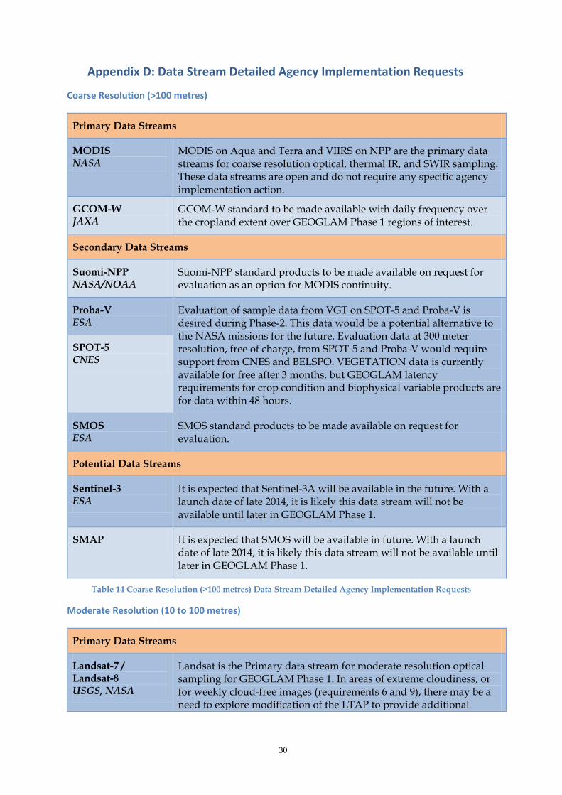
Appendix D: Data Stream Detailed Agency Implementation Requests
Coarse Resolution (>100 metres)
Primary Data Streams
MODIS NASA
MODIS on Aqua and Terra and VIIRS on NPP are the primary data streams for coarse resolution optical, thermal IR, and SWIR sampling. These data streams are open and do not require any specific agency implementation action.
GCOM-W JAXA
GCOM-W standard to be made available with daily frequency over the cropland extent over GEOGLAM Phase 1 regions of interest.
Secondary Data Streams
Suomi-NPP NASA/NOAA
Suomi-NPP standard products to be made available on request for evaluation as an option for MODIS continuity.
Proba-V ESA
Evaluation of sample data from VGT on SPOT-5 and Proba-V is desired during Phase-2. This data would be a potential alternative to the NASA missions for the future. Evaluation data at 300 meter resolution, free of charge, from SPOT-5 and Proba-V would require support from CNES and BELSPO. VEGETATION data is currently available for free after 3 months, but GEOGLAM latency requirements for crop condition and biophysical variable products are for data within 48 hours.
SPOT-5 CNES
SMOS ESA
SMOS standard products to be made available on request for evaluation.
Potential Data Streams
Sentinel-3 ESA
It is expected that Sentinel-3A will be available in the future. With a launch date of late 2014, it is likely this data stream will not be available until later in GEOGLAM Phase 1.
SMAP It is expected that SMOS will be available in future. With a launch date of late 2014, it is likely this data stream will not be available until later in GEOGLAM Phase 1.
Table 14 Coarse Resolution (>100 metres) Data Stream Detailed Agency Implementation Requests
Moderate Resolution (10 to 100 metres)
Primary Data Streams
Landsat-7 / Landsat-8 USGS, NASA
Landsat is the Primary data stream for moderate resolution optical sampling for GEOGLAM Phase 1. In areas of extreme cloudiness, or for weekly cloud-free images (requirements 6 and 9), there may be a need to explore modification of the LTAP to provide additional
30

acquisitions. These data streams are open and do not require any specific agency implementation action to access.
RADARSAT-2 CSA
RADARSAT-2 is a Primary data stream for Asia-RiCE during GEOGLAM Phase 1. CSA is currently facilitating access under its SOAR-JECAM program, and this is expected to continue.
Sentinel-1 ESA
Sentinel-1 is expected to launch in late 2013, and is a Primary data stream for Asia-RiCE during GEOGLAM Phase 1. Data as early as possible during the ramp-up and operations phases are being requested.
Secondary Data Streams
RESOURCESAT-2 ISRO
Sample products from ResourceSat-2 (AWIFS) are desired for evaluation as a possible supplement the Primary moderate resolution data streams. ISRO has already acquired 11 cloud-free scenes over Argentina between November 2011 and February 2013 in support of support JECAM.
TerraSAR-X DLR
Sample products from TerraSAR-X are desired for evaluation by the Asia-RiCE team for rice crop monitoring. DLR is working to make this data available through applications development channels.
RISAT-1 ISRO
Sample products from RISAT-1 are desired for evaluation by Asia-RiCE over the Technical Demonstration sites during GEOGLAM Phase 1.
Potential Data Streams
Sentinel-2 ESA
It is expected that Sentinel-2A will be available in future. With a launch date of late 2014, it is likely this data stream will not be available until later in GEOGLAM Phase 1.
ALOS-2 It is expected that ALOS-2 will be available in future. With a launch date in JFY 2013-14, it is likely this data stream could support GEOGLAM Phase 1. Potential applications for Asia-RiCE, and other crop types should be considered, though data policy and access remains to be clarified.
CBERS-3 It is expected that CBERS-3 will be available in future. With a launch date of late 2013, it is likely this data stream could support GEOGLAM Phase 1. Coverage over GEOGLAM Phase 1 areas of interest remains to be coordinated.
Table 15 Moderate Resolution (10 to 100 metres) Data Stream Detailed Agency Implementation Requests
Fine Resolution (5 to 10 meters)
Primary Data Streams
31

RapidEye Commercial
The RapidEye Constellation is the primary source of fine resolution optical sampling for GEOGLAM Phase 1. These data are available commercially, and support from DLR and other agencies may enable the acquisition and evaluation sample datasets. To date, RapidEye data has been secured in support of the JECAM projects, and this is expected to continue.
Secondary Data Streams
SPOT-5 Commercial
SPOT-5 (HRG) is a secondary data source. These data are also fee-based, but support from CNES may allow acquisition and evaluation of free sample datasets.
Potential Data Streams
-
Table 16 Fine Resolution (5 to 10 metres) Data Stream Detailed Agency Implementation Requests
Very Fine Resolution (<5 meters)Primary Data Streams
-
Secondary Data Streams
Pleiades Commercial
For very fine resolution applications in small fields (i.e., Uganda), the Pleiades 1A/1B (HIRI) missions are a potential data stream. These data are commercial, but support from CNES may enable access to sample datasets. This data may be used in Phase-1B, but will likely not be used until Phase-2.
Potential Data Streams
-
Table 17 Very Fine Resolution (<5 metres) Data Stream Detailed Agency Implementation Requests
32

Appendix E: Assessment of Landsat Cloud Cover Together, the Landsat-7 and Landsat-8 missions offer an 8-day revisit time, with each individual satellite revisiting every 16-days. Data are acquired during every opportunity over U.S. territory, as well as in South America and in Australia within the Brazilian and Australian ground station masks. Globally, the LTAP aims at achieving at least four cloud-free coverages of every land locale per year, with the exception of smaller Pacific islands which may require individual acquisition requests. The average duty cycles of the two systems is 10 – 11 minutes per orbit, corresponding to about 380 scenes/day for Landsat-7 and some 400 scenes/day for Landsat-8.
In regions with persistent cloud cover, analysis from Landsat-7 actual acquisitions has shown that the number of observations based on the LTAP have not been sufficient to achieve this goal of four cloud-free coverages per year.
Figure 15 Landsat 7, ETM+, 183-km x 170km scenes over croplands in Argentina.
This region will require 9 paths (west to east) and 78 scenes.
33

Table 18 Landsat 7, ETM+, 183-km x 170km scenes over croplands in Argentina.
This region will require 9 paths (west to east) and 78 scenes.
Figure 16 Landsat 7, ETM+, 183-km x 170km scenes over croplands in Australia.
This region will require 22 paths (west to east) and 90 scenes.
34
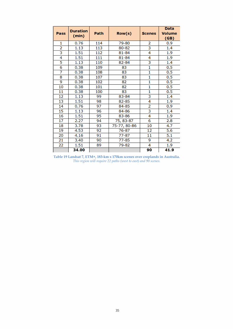
Table 19 Landsat 7, ETM+, 183-km x 170km scenes over croplands in Australia.
This region will require 22 paths (west to east) and 90 scenes.
35
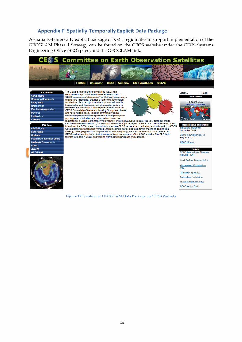
Appendix F: Spatially-Temporally Explicit Data Package A spatially-temporally explicit package of KML region files to support implementation of the GEOGLAM Phase 1 Strategy can be found on the CEOS website under the CEOS Systems Engineering Office (SEO) page, and the GEOGLAM link.
Figure 17 Location of GEOGLAM Data Package on CEOS Website
36