Central Park Station Final Draft - denvergov.org · tion matrix, which also categorizes each...
85
Central Park Station Area Plan September 24, 2012
Transcript of Central Park Station Final Draft - denvergov.org · tion matrix, which also categorizes each...

Central Park Station
Area Plan
September 24, 2012
Mayor Michael B. Hancock
DENVER CITY COUNCIL
District 1- Susan K. Shepherd
District 2- Jeanne Faatz
District 3- Paul D. López
District 4- Peggy Lehmann
District 5- Mary Beth Susman, President
District 6- Charlie Brown
District 7- Chris Nevitt
District 8- Albus Brooks
District 9- Judy H. Montero
District 10- Jeanne Robb
District 11- Christopher Herndon, President Pro Tem
At-Large- Robin Kniech
At-Large- Deborah (Debbie) Ortega
DENVER PLANNING BOARD
Brad Buchanan, Chairman
Andy Baldyga
Julie Bender
Richard Delanoy
Shannon Giff ord
Kenneth Ho
Anna Jones
Brittany Morris Saunders
Sharon Nunnally
Susan Pearce
K.C. Veio
Dave Webster
COMMUNITY PLANNING & DEVELOPMENT
Molly Urbina, Interim Manager
Steve Gordon, Comprehensive Planning Manager
David Gaspers, Project Manager
Theresa Lucero, Project Manager
Caryn Wenzara
Steve Nalley
Tim Watkins
Eric McClelland
Carolyne Janssen
FINANCE
Bar Chadwick
PUBLIC WORKS
Jose Cornejo, Manager
Crissy Fanganello, Policy and Planning Director
Emily Silverman
Jennifer Hillhouse
Eric Osmundson
Emily Snyder
Becky Simon
Mike Anderson
Walt Hime
Russ Price
Justin Schmitz
PARKS & RECREATION
Lauri Dannemiller, Manager
Gordon Robertson, Park Planning, Design and Construction Director
David Marquardt, Landscape Architect Supervisor
Mark Upshaw
OFFICE OF ECONOMIC DEVELOPMENT
Jeff Romine
Christopher Smith
Stephanie Inderwiesen
ARTS AND VENUES
Kendall Peterson
STAPLETON ART PROGRAM
Barbara Neal
HEALTH IMPACT ASSESSEMENT
Alisha Brown, Director - BeWell Stapleton
Karen Roof - Envirohealth Consulting
Chad Reischl - Envirohealth Consulting
Bill Sadler - Envirohealth Consulting
Carrie Murphy - Envirohealth Consulting
KEY STAKEHOLDER GROUP
Angie Malpiede, Chair
Charles Bayley
Keven Burnett
Jim Chrisman
Cheryl Cohen-Vader
Beverly Haddon
Donn Hogan
Rhonda Jones
Jody Martin-Witt
Bette Matkowski
Tom Michals
David Netz
Justin Ross
Andrew Schurger
Heather Shockey
John Smith
Patrick Stanley
Mike Turner
Michele Wheeler
Rob Wilson
Ex-Offi cio Members
Councilmember Chris Herndon
State Representative Angela Williams
A c k n o w l e d g e m e n t s
Introduction .................................................. 1Planning Approach ........................................................................... 2Planning Process ............................................................................... 4Planning Context ............................................................................... 6
Strategy Framework ..................................... 9Accomplishments, Challenges, Opportunities .....................10Vision and Principles ......................................................................12Overall Plan Concept......................................................................14A. Destination ..................................................................................16B. Active .............................................................................................24C. Accessible .....................................................................................32D. Sustainable ...................................................................................40
Transformative Projects ............................. 47Uinta Street........................................................................................48Improved Street Network .............................................................52Sand Creek Trail Connections ....................................................54Station Landmark ............................................................................56Innovative Station Site Design ...................................................58Quebec Square Redevelopment................................................62Intermodal Transportation Center.............................................66Bike Sharing and Rental Program..............................................68
Moving Forward ......................................... 71

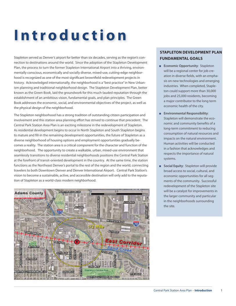
Central Park Station Area Plan – Introduction 1
I n t r o d u c t i o n
Stapleton served as Denver’s airport for better than six decades, serving as the region’s con-nection to destinations around the world. Since the adoption of the Stapleton Development Plan, the process to turn the former Stapleton International Airport into a thriving, environ-mentally conscious, economically and socially diverse, mixed-use, cutting-edge neighbor-hood is recognized as one of the most signifi cant brownfi eld redevelopment projects in history. Acknowledged internationally, the neighborhood is a “best practice” in New Urban-ism planning and traditional neighborhood design. The Stapleton Development Plan, better known as the Green Book, laid the groundwork for this much-lauded reputation through the establishment of an ambitious vision, fundamental goals, and plan principles. The Green Book addresses the economic, social, and environmental objectives of the project, as well as the physical design of the neighborhood.
The Stapleton neighborhood has a strong tradition of outstanding citizen participation and involvement and this station area planning eff ort has strived to continue that precedent. The Central Park Station Area Plan is an exciting milestone in the redevelopment of Stapleton. As residential development begins to occur in North Stapleton and South Stapleton begins to mature and fi ll-in the remaining development opportunities, the future of Stapleton as a diverse neighborhood of housing options and employment opportunities gradually be-comes a reality. The station area is a critical component for the character and function of the neighborhood. The opportunity to create a walkable, urban, mixed-use environment that seamlessly transitions to diverse residential neighborhoods positions the Central Park Station at the forefront of transit-oriented development in the country. At the same time, the station functions as the Northeast Denver’s portal to the rest of the region and the world, connecting travelers to both Downtown Denver and Denver International Airport. Central Park Station’s vision to become a sustainable, active, and accessible destination will only add to the reputa-tion of Stapleton as a world-class modern neighborhood.
STAPLETON DEVELOPMENT PLAN
FUNDAMENTAL GOALS
■ Economic Opportunity: Stapleton will be a regional center for job cre-ation in diverse fi elds, with an empha-sis on new technologies and emerging industries. When completed, Staple-ton could support more than 30,000 jobs and 25,000 residents, becoming a major contributor to the long term economic health of the city.
■ Environmental Responsibility: Stapleton will demonstrate the eco-nomic and community benefi ts of a long-term commitment to reducing consumption of natural resources and impacts on the natural environment. Human activities will be conducted in a fashion that acknowledges and respects the importance of natural systems.
■ Social Equity: Stapleton will provide broad access to social, cultural, and economic opportunities for all seg-ments of the community. Successful redevelopment of the Stapleton site will be a catalyst for improvements in the larger community and particular in the neighborhoods surrounding the site.
Central Park Station Area Plan – Introduction2
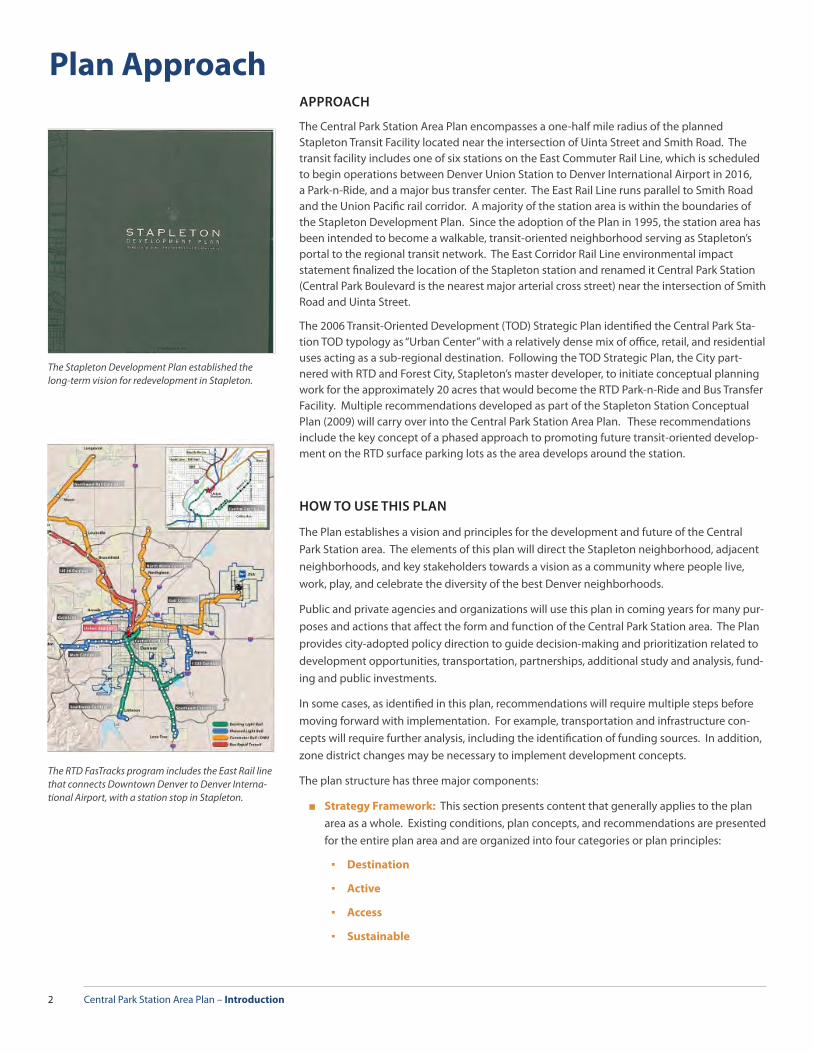
Plan ApproachAPPROACH
The Central Park Station Area Plan encompasses a one-half mile radius of the planned Stapleton Transit Facility located near the intersection of Uinta Street and Smith Road. The transit facility includes one of six stations on the East Commuter Rail Line, which is scheduled to begin operations between Denver Union Station to Denver International Airport in 2016, a Park-n-Ride, and a major bus transfer center. The East Rail Line runs parallel to Smith Road and the Union Pacifi c rail corridor. A majority of the station area is within the boundaries of the Stapleton Development Plan. Since the adoption of the Plan in 1995, the station area has been intended to become a walkable, transit-oriented neighborhood serving as Stapleton’s portal to the regional transit network. The East Corridor Rail Line environmental impact statement fi nalized the location of the Stapleton station and renamed it Central Park Station (Central Park Boulevard is the nearest major arterial cross street) near the intersection of Smith Road and Uinta Street.
The 2006 Transit-Oriented Development (TOD) Strategic Plan identifi ed the Central Park Sta-tion TOD typology as “Urban Center” with a relatively dense mix of offi ce, retail, and residential uses acting as a sub-regional destination. Following the TOD Strategic Plan, the City part-nered with RTD and Forest City, Stapleton’s master developer, to initiate conceptual planning work for the approximately 20 acres that would become the RTD Park-n-Ride and Bus Transfer Facility. Multiple recommendations developed as part of the Stapleton Station Conceptual Plan (2009) will carry over into the Central Park Station Area Plan. These recommendations include the key concept of a phased approach to promoting future transit-oriented develop-ment on the RTD surface parking lots as the area develops around the station.
HOW TO USE THIS PLAN
The Plan establishes a vision and principles for the development and future of the Central Park Station area. The elements of this plan will direct the Stapleton neighborhood, adjacent neighborhoods, and key stakeholders towards a vision as a community where people live, work, play, and celebrate the diversity of the best Denver neighborhoods.
Public and private agencies and organizations will use this plan in coming years for many pur-poses and actions that aff ect the form and function of the Central Park Station area. The Plan provides city-adopted policy direction to guide decision-making and prioritization related to development opportunities, transportation, partnerships, additional study and analysis, fund-ing and public investments.
In some cases, as identifi ed in this plan, recommendations will require multiple steps before moving forward with implementation. For example, transportation and infrastructure con-cepts will require further analysis, including the identifi cation of funding sources. In addition, zone district changes may be necessary to implement development concepts.
The plan structure has three major components:
■ Strategy Framework: This section presents content that generally applies to the plan area as a whole. Existing conditions, plan concepts, and recommendations are presented for the entire plan area and are organized into four categories or plan principles:
▪ Destination
▪ Active
▪ Access
▪ Sustainable
The Stapleton Development Plan established the long-term vision for redevelopment in Stapleton.
The RTD FasTracks program includes the East Rail line that connects Downtown Denver to Denver Interna-tional Airport, with a station stop in Stapleton.
Central Park Station Area Plan – Introduction 3
■ Transformative Concepts: These are big ideas that, if implemented, could help to cata-lyze private investment.
▪ Uinta Street
▪ Improved Street Network
▪ Sand Creek Trail Connections
▪ Station Landmark
▪ Innovative Station Site Design
▪ Quebec Square Redevelopment
▪ Intermodal Transportation Center
▪ Bike Sharing and Rental Program
■ Moving Forward: This section addresses the implementation framework for the plan. All of the plan recommendations from previous chapters are listed in the implementa-tion matrix, which also categorizes each recommendation in terms of timing, type, and potential funding sources.
Eff orts were made to eliminate redundancies in plan recommendations. Therefore, recom-mendations appear once in the plan and although they may be referenced in other chapters, they are generally not repeated as recommendations in multiple chapters. For example, the transformative concepts are identifi ed as recommendations in the Strategy Framework, but greater detail is provided for each recommendation in the transformative concepts section.
BRIEF HISTORY OF STAPLETON
INTERNATIONAL AIRPORT
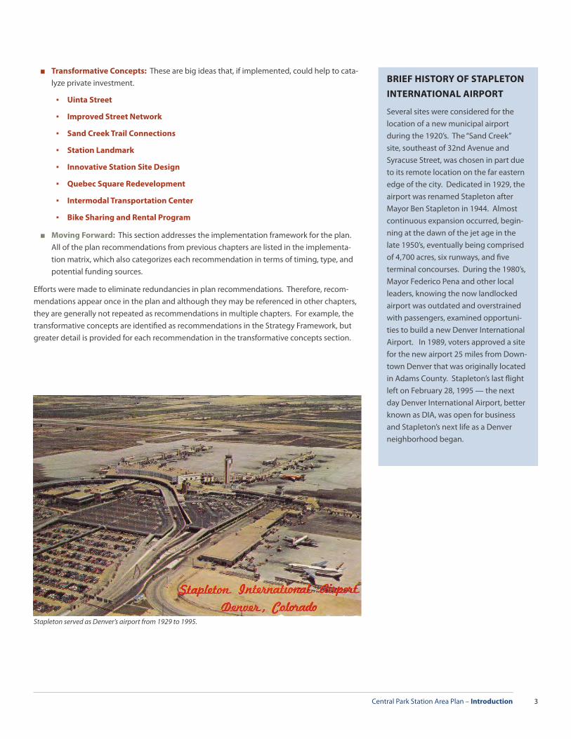
Several sites were considered for the location of a new municipal airport during the 1920’s. The “Sand Creek” site, southeast of 32nd Avenue and Syracuse Street, was chosen in part due to its remote location on the far eastern edge of the city. Dedicated in 1929, the airport was renamed Stapleton after Mayor Ben Stapleton in 1944. Almost continuous expansion occurred, begin-ning at the dawn of the jet age in the late 1950’s, eventually being comprised of 4,700 acres, six runways, and fi ve terminal concourses. During the 1980’s, Mayor Federico Pena and other local leaders, knowing the now landlocked airport was outdated and overstrained with passengers, examined opportuni-ties to build a new Denver International Airport. In 1989, voters approved a site for the new airport 25 miles from Down-town Denver that was originally located in Adams County. Stapleton’s last fl ight left on February 28, 1995 — the next day Denver International Airport, better known as DIA, was open for business and Stapleton’s next life as a Denver neighborhood began.
Stapleton served as Denver’s airport from 1929 to 1995.

Central Park Station Area Plan – Introduction4
The public process for the Central Park Station Area Plan kicked of in June 2011 with a public meeting to begin development of the draft plan vision and principles, which included a brain-storming activity to generate potential plan concepts. The organizing structure of the plan document is closely tied to the plan vision and principles, as the concepts and recommenda-tions are intended to relate back to the four core principles expressed in the plan vision. After the initial kickoff meeting, the Stapleton Foundation and Stapleton Transportation Manage-ment Association (TMA) assisted City staff in forming a Key Stakeholder Group to refi ne the plan vision and principles and aid City staff in developing the plan concepts. The Key Stakeholder Group met fi ve times between September 2011 and February 2012. Meetings with individual stakeholders, such as RTD, the Stapleton Foundation, Stapleton TMA, BeWell Stapleton, and Forest City helped to shape plan content throughout the process. A concur-rent planning eff ort, a station area health impact assessment (HIA), funded by the Stapleton Foundation, informed many of the plan recommendations. The HIA had a broader study area than the station area plan, looking at health impacts to neighborhoods within a mile and a half of the station. The process also involved collaboration between the City and County of Denver’s Community Planning and Development Department, the Public Works Department, the Department of Parks and Recreation, the Department of Arts and Venues, and the Offi ce of Economic Development. A second public meeting occurred on June 14, 2012 to present the plan concepts and draft document. Briefi ngs and public hearings with City Council, Den-ver Planning Board and interagency City staff were also crucial to the process.
PUBLIC INVOLVEMENT PROCESS:
■ Key Stakeholder Group (KSG) - The key responsibility for the Key Stakeholder Group was to craft a plan vision and principles that is refl ective of the larger Northeast Denver community and guide city staff in developing plan concepts and recommendations that lead to the implementation of that vision. Throughout the plan process, the KSG was able to provide invaluable feedback to City staff on key issues, available opportunities, and potential partnerships while distributing information about the plan to the larger community. There were fi ve KSG meetings held at the offi ces of the Stapleton Founda-tion over the course of the process. Key Stakeholder Group members included represen-tatives from the Stapleton Development Corporation, Stapleton Foundation, Stapleton TMA, Citizen’s Advisory Board, Stapleton Master Community Association, Stapleton United Neighbors, nearby neighborhood groups, business owners, Forest City, and RTD. City and County of Denver District 11 Councilmember Chris Herndon and Colorado State Representative Angela Williams served as ex-offi cio members of the Key Stakeholder Group.
■ Individual Stakeholder Interviews - Throughout the station area plan process, a series of informal interviews were conducted with local citizens, land owners, and City and County of Denver agencies to identify current initiatives and understand key issues within the study area. These interviews were a supplement to the public process and helped to uncover local dynamics.
■ Public Meetings - In addition to meetings with the KSG members and various stake-holders, two public meetings were held to engage the community on key issues. This process included:
▪ Public Meeting #1- June 29, 2011 - The formal public kick-off meeting was an introduction to the station area planning process with a presentation on the exist-ing station area conditions and policies, previous station area planning work, and examples of Transit-Oriented Development. This was followed by a draft plan vision, principles, and concepts. There was then an open house session designed to gather
The Stapleton Master Community Association is one of many community organizations that contributed to the public involvement process.
Planning Process
The Key Stakeholder Group meetings were hosted by the Stapleton Foundation, located in the 29th Street Town Center.

Central Park Station Area Plan – Introduction 5
ideas and input by focusing on three main questions: What do you like? What do you not like? How would you change it?
▪ Public Meeting #2- June 14, 2012 - This public meeting was held to review the fi nal plan concepts and recommendations developed by the Key Stakeholder Group and provide comments or ask questions of city staff who produced the draft plan docu-ment. After an initial presentation, a question and answer session and open house ensued.
CENTRAL PARK STATION HEALTH IMPACT ASSESSMENT
At the outset of the process of developing the Central Park Station Area Plan, the Stapleton Foundation for Sustainable Urban Communities hired EnviroHealth Consult-ing to assist with completing a Health Impact Assessment (HIA), which examines how the built environment aff ects residents’ health. The HIA covers the station area and the communities within a mile and a half from the station. The study area for the HIA con-tains neighborhoods as well as commercial and industrial areas located within a broad rectangle bounded by Montview Blvd, Holly St., 56nd Ave. and Peoria St. The HIA focuses primarily on the residential neighborhoods of Northeast (NE) Park Hill, North (N) Park Hill, Northwest (NW) Aurora and much of Stapleton. Five primary questions are addressed by the HIA:
■ What is the current health status of the population within the study area and how might it be aff ected (positively and negatively) by the Central Park Station and devel-opment at the TOD Site?
■ What pedestrian and bicycle routes should be enhanced/created in order to better connect local residents and employees to the station area?
■ What transit routes would help connect local residents and employees to the station area, employment centers and other local services?
■ What programming and/or housing policy would be necessary to ensure a diverse population of the people, within the neighborhoods in the study area, benefi t from the development of the TOD Site?
■ What need (if any) is there for a grocery store that sells and promotes healthy and af-fordable food items near the TOD Site?
The HIA evaluates the availability of transportation options, housing quality, access to jobs, recreation, and healthy food for residents within the study area and describes the opportunities that exist for incorporating health recommendations into the Central Park Station Area Plan. The goal of the HIA is to improve local decision making, explicitly address health impacts of underserved populations and broadly promote health and well-being.
The goal of the Central Park Station Health Impact Assessment is to improve local decision making, explictly address health impacts of underserved populations and broadly promote health and well-being.
Central Park Station Area Plan – Introduction6
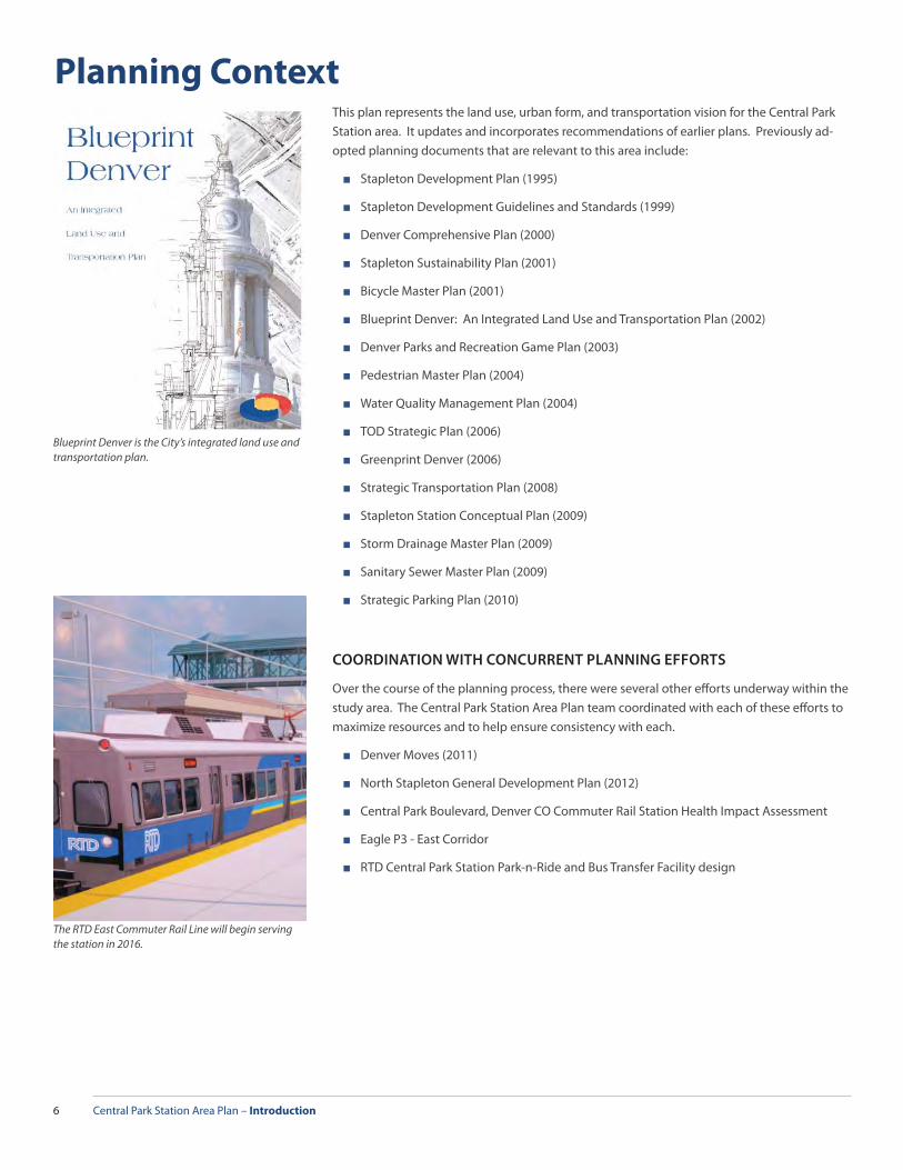
Planning ContextThis plan represents the land use, urban form, and transportation vision for the Central Park Station area. It updates and incorporates recommendations of earlier plans. Previously ad-opted planning documents that are relevant to this area include:
■ Stapleton Development Plan (1995)
■ Stapleton Development Guidelines and Standards (1999)
■ Denver Comprehensive Plan (2000)
■ Stapleton Sustainability Plan (2001)
■ Bicycle Master Plan (2001)
■ Blueprint Denver: An Integrated Land Use and Transportation Plan (2002)
■ Denver Parks and Recreation Game Plan (2003)
■ Pedestrian Master Plan (2004)
■ Water Quality Management Plan (2004)
■ TOD Strategic Plan (2006)
■ Greenprint Denver (2006)
■ Strategic Transportation Plan (2008)
■ Stapleton Station Conceptual Plan (2009)
■ Storm Drainage Master Plan (2009)
■ Sanitary Sewer Master Plan (2009)
■ Strategic Parking Plan (2010)
COORDINATION WITH CONCURRENT PLANNING EFFORTS
Over the course of the planning process, there were several other eff orts underway within the study area. The Central Park Station Area Plan team coordinated with each of these eff orts to maximize resources and to help ensure consistency with each.
■ Denver Moves (2011)
■ North Stapleton General Development Plan (2012)
■ Central Park Boulevard, Denver CO Commuter Rail Station Health Impact Assessment
■ Eagle P3 - East Corridor
■ RTD Central Park Station Park-n-Ride and Bus Transfer Facility design
The RTD East Commuter Rail Line will begin serving the station in 2016.
Blueprint Denver is the City’s integrated land use and transportation plan.

Central Park Station Area Plan – Introduction 7

Central Park Station Area Plan – Strategy Framework 9
S t r a t e g y F r a m e w o r k
Central Park Station will serve as a critical portal to Stapleton and adjacent neighborhoods from the entire Denver region. Identifying key Accomplishments, Challenges, and Opportuni-ties at the beginning of this chapter sets the stage for the plan’s concepts and recommenda-tions and provides an understanding of the needs of the area.
The Overall Plan Concept, Vision, and Principles establish a snapshot of the Central Park Sta-tion Area Plan. The Key Stakeholder Group took great care in refi ning the Vision and Prin-ciples, as they not only provide the desired expectations for the station area but also establish a standard to judge the validity of the plan’s concepts and recommendations. The Plan Principles serving as the evaluation criteria are:
■ Destination
■ Active
■ Accessible
■ Sustainable
Each plan principle has a set of detailed concepts that infl uence a specifi c aspect of the sta-tion area. Concepts that further the vision through all four plan principles have been elevated to Transformative Concepts. The long-term success and value of the Central Park Station Area Plan will depend on how the plan concepts, especially the Transformative Concepts, are implemented as real world projects and what resulting actions occur to capitalize on those projects.
Central Park Station Area Plan – Strategy Framework10
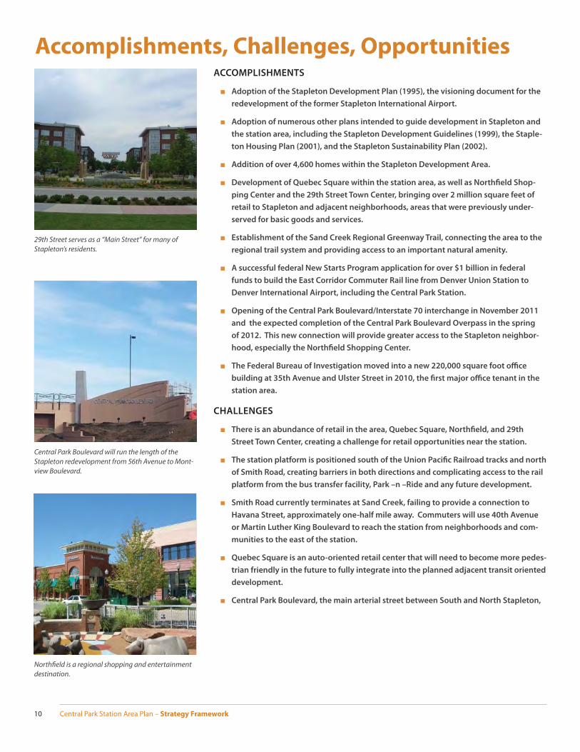
Accomplishments, Challenges, OpportunitiesACCOMPLISHMENTS
■ Adoption of the Stapleton Development Plan (1995), the visioning document for the
redevelopment of the former Stapleton International Airport.
■ Adoption of numerous other plans intended to guide development in Stapleton and
the station area, including the Stapleton Development Guidelines (1999), the Staple-
ton Housing Plan (2001), and the Stapleton Sustainability Plan (2002).
■ Addition of over 4,600 homes within the Stapleton Development Area.
■ Development of Quebec Square within the station area, as well as Northfi eld Shop-
ping Center and the 29th Street Town Center, bringing over 2 million square feet of
retail to Stapleton and adjacent neighborhoods, areas that were previously under-
served for basic goods and services.
■ Establishment of the Sand Creek Regional Greenway Trail, connecting the area to the
regional trail system and providing access to an important natural amenity.
■ A successful federal New Starts Program application for over $1 billion in federal
funds to build the East Corridor Commuter Rail line from Denver Union Station to
Denver International Airport, including the Central Park Station.
■ Opening of the Central Park Boulevard/Interstate 70 interchange in November 2011
and the expected completion of the Central Park Boulevard Overpass in the spring
of 2012. This new connection will provide greater access to the Stapleton neighbor-
hood, especially the Northfi eld Shopping Center.
■ The Federal Bureau of Investigation moved into a new 220,000 square foot offi ce
building at 35th Avenue and Ulster Street in 2010, the fi rst major offi ce tenant in the
station area.
CHALLENGES
■ There is an abundance of retail in the area, Quebec Square, Northfi eld, and 29th
Street Town Center, creating a challenge for retail opportunities near the station.
■ The station platform is positioned south of the Union Pacifi c Railroad tracks and north
of Smith Road, creating barriers in both directions and complicating access to the rail
platform from the bus transfer facility, Park –n –Ride and any future development.
■ Smith Road currently terminates at Sand Creek, failing to provide a connection to
Havana Street, approximately one-half mile away. Commuters will use 40th Avenue
or Martin Luther King Boulevard to reach the station from neighborhoods and com-
munities to the east of the station.
■ Quebec Square is an auto-oriented retail center that will need to become more pedes-
trian friendly in the future to fully integrate into the planned adjacent transit oriented
development.
■ Central Park Boulevard, the main arterial street between South and North Stapleton,
29th Street serves as a “Main Street” for many of Stapleton’s residents.
Northfi eld is a regional shopping and entertainment destination.
Central Park Boulevard will run the length of the Stapleton redevelopment from 56th Avenue to Mont-view Boulevard.
Central Park Station Area Plan – Strategy Framework 11
will see increasing traffi c levels as Stapleton fully develops, potentially becoming a
barrier for pedestrian and bicycle traffi c to and from the east.
■ Quebec Street is a major arterial roadway acting as a barrier to the station from
neighborhoods to and from the west.
■ I-70 can be a barrier for pedestrians and bicyclists to and from the north.
■ Central Park Boulevard is the only grade separated crossing of the UPRR ROW in the
study area, limiting north-south connectivity.
■ Market competition from other TOD locations exists for higher density residential and
offi ces uses.
■ Ulster Street is an at-grade crossing of the Union Pacifi c and future East Rail line tracks
that provides the predominant access to the existing Stapleton Industrial Area.
■ The need to balance goals of a walkable, urban neighborhood versus the needs of a
busy Park-n-Ride in the RTD system.
OPPORTUNITIES
■ A large portion of the station area is a brownfi eld redevelopment site at various
stages of environmental remediation.
■ Strong cooperation from partners – RTD and Forest City – both committed to the long
term vision of a walkable, mixed-use neighborhood near Central Park Station.
■ Stapleton provides a growing, desirable residential neighborhood capable of sup-
porting a signifi cant employment center near the station.
■ Strong bicycle and pedestrian infrastructure already exists within Stapleton’s residen-
tial neighborhoods.
■ Long-term redevelopment opportunities exist to intensify the uses within Quebec
Square, transferring the shopping center into a more walkable, mixed-use neighbor-
hood.
■ There is an identifi ed need in Stapleton for higher density multi-family housing.
■ The station incorporates an established, busy, bus transfer facility that provides
transit connections to adjacent neighborhoods as well as destinations throughout
the region.
■ The station is located at a convenient location approximately half way between DIA
and Downtown Denver on the East Commuter Rail Line.
■ I-70 is a major regional roadway, moving thousands of people through the region,
providing access to Downtown and DIA, and generating economic activity and jobs at
nearby employment centers.
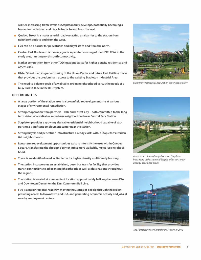
As a master planned neighborhood, Stapleton has strong pedestrian and bicycle infrastructure in already developed areas
The FBI relocated to Central Park Station in 2010
Stapleton’s residential population continues to grow

Central Park Station Area Plan – Strategy Framework12
Vision and PrinciplesA key to the development of the Central Park Station Area Plan was the establishment of a strong plan vision and plan principles. The kickoff meeting provided a draft version of the plan vision and principles to the public for initial input and the Key Stakeholder Group later refi ned the vision and principles to ensure they provided the correct framework for the entire plan. The vision describes the area as it could be twenty or more years into the future, while the principles establish specifi c elements that this plan should strive to achieve.
VISION STATEMENT
Central Park Station will be a sustainable, active, and accessible destination for Stapleton, nearby neighborhoods, and the Denver region.
PLAN PRINCIPLES
A. Destination – The station area will serve as a crossroads of the Stapleton neighbor-hood, connecting people from all segments of the community to the diverse activities found throughout Stapleton and the Denver region.
B. Active – The station area will be a safe, vibrant, urban place that provides stimulating, enjoyable, and convenient activities and amenities for a wide variety of diff erent users.
C. Accessible – The station area will build upon its regional connections to provide an extremely high level of mobility and multi-modal access for all users in a safe, easy, and convenient manner.
D. Sustainable – The station area will seek innovative ways to better nurture natural, economic, and social systems and resources for today and future generations.
These four principles are used as a measuring stick to assess the degree to which any given plan concept helps to promote or achieve a broad array of goals. In this way, the principles are both an organizing element for the plan and a means by which to evaluate its content.
Quebec Square Improved Street Network
Station ITC Innovative Park N Ride
Sand Creek Trail Connections Bike Sharing
Landmark Mobility
Urban Design
Use and Form
Affordable Housing
Plan Vision
Plan Principles
Plan Concepts
Central Park Station Area Plan – Strategy Framework 13
REDEVELOPMENT OF
AN AIRPORT
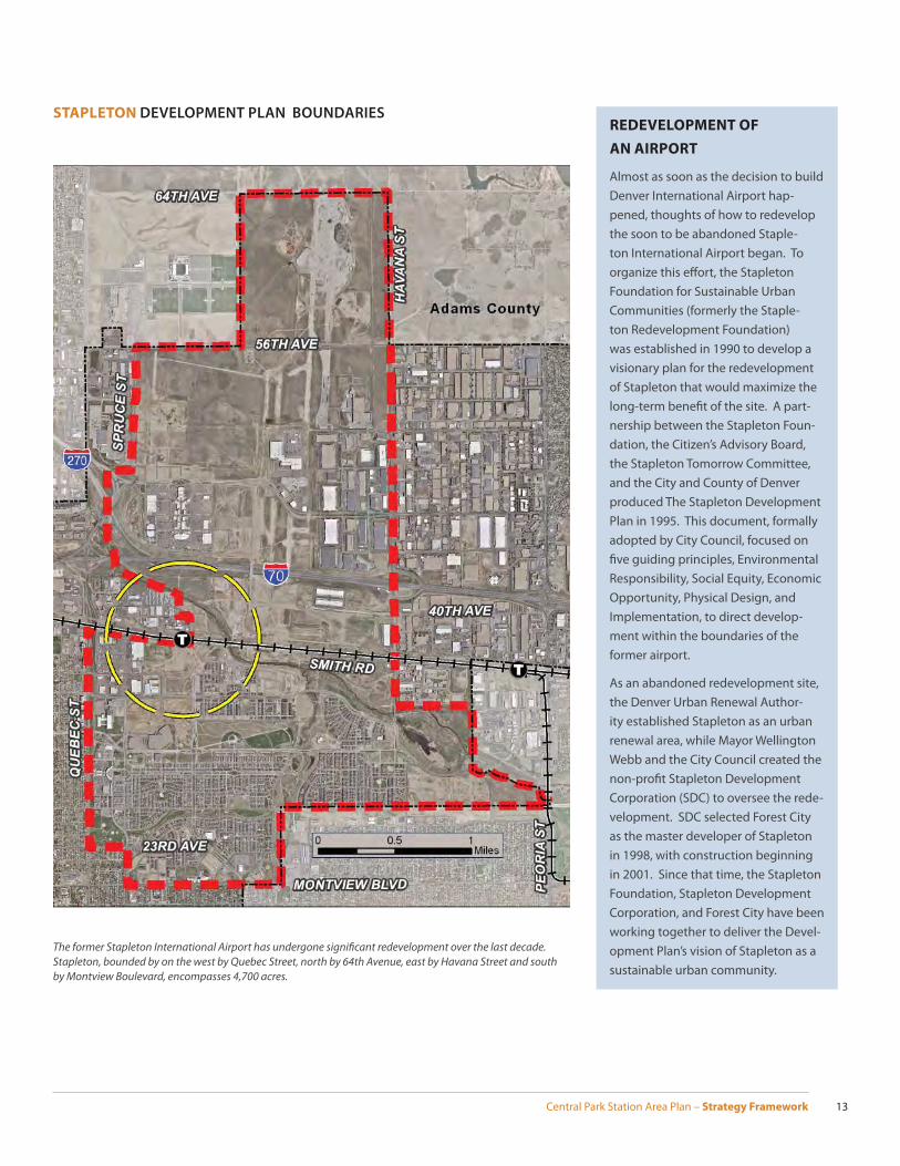
Almost as soon as the decision to build Denver International Airport hap-pened, thoughts of how to redevelop the soon to be abandoned Staple-ton International Airport began. To organize this eff ort, the Stapleton Foundation for Sustainable Urban Communities (formerly the Staple-ton Redevelopment Foundation) was established in 1990 to develop a visionary plan for the redevelopment of Stapleton that would maximize the long-term benefi t of the site. A part-nership between the Stapleton Foun-dation, the Citizen’s Advisory Board, the Stapleton Tomorrow Committee, and the City and County of Denver produced The Stapleton Development Plan in 1995. This document, formally adopted by City Council, focused on fi ve guiding principles, Environmental Responsibility, Social Equity, Economic Opportunity, Physical Design, and Implementation, to direct develop-ment within the boundaries of the former airport.
As an abandoned redevelopment site, the Denver Urban Renewal Author-ity established Stapleton as an urban renewal area, while Mayor Wellington Webb and the City Council created the non-profi t Stapleton Development Corporation (SDC) to oversee the rede-velopment. SDC selected Forest City as the master developer of Stapleton in 1998, with construction beginning in 2001. Since that time, the Stapleton Foundation, Stapleton Development Corporation, and Forest City have been working together to deliver the Devel-opment Plan’s vision of Stapleton as a sustainable urban community.
The former Stapleton International Airport has undergone signifi cant redevelopment over the last decade. Stapleton, bounded by on the west by Quebec Street, north by 64th Avenue, east by Havana Street and south by Montview Boulevard, encompasses 4,700 acres.
STAPLETON DEVELOPMENT PLAN BOUNDARIES
Central Park Station Area Plan – Strategy Framework14
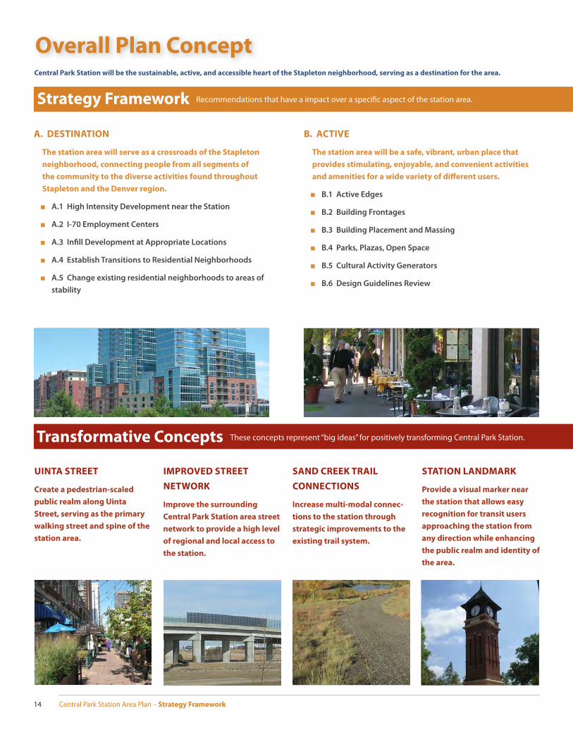
Overall Plan Concept
Strategy Framework Recommendations that have a impact over a specifi c aspect of the station area.
Transformative Concepts These concepts represent “big ideas” for positively transforming Central Park Station.
Central Park Station will be the sustainable, active, and accessible heart of the Stapleton neighborhood, serving as a destination for the area.
IMPROVED STREET
NETWORK
Improve the surrounding
Central Park Station area street
network to provide a high level
of regional and local access to
the station.
SAND CREEK TRAIL
CONNECTIONS
Increase multi-modal connec-
tions to the station through
strategic improvements to the
existing trail system.
STATION LANDMARK
Provide a visual marker near
the station that allows easy
recognition for transit users
approaching the station from
any direction while enhancing
the public realm and identity of
the area.
UINTA STREET
Create a pedestrian-scaled
public realm along Uinta
Street, serving as the primary
walking street and spine of the
station area.
A. DESTINATION
The station area will serve as a crossroads of the Stapleton
neighborhood, connecting people from all segments of
the community to the diverse activities found throughout
Stapleton and the Denver region.
■ A.1 High Intensity Development near the Station
■ A.2 I-70 Employment Centers
■ A.3 Infi ll Development at Appropriate Locations
■ A.4 Establish Transitions to Residential Neighborhoods
■ A.5 Change existing residential neighborhoods to areas of
stability
B. ACTIVE
The station area will be a safe, vibrant, urban place that
provides stimulating, enjoyable, and convenient activities
and amenities for a wide variety of diff erent users.
■ B.1 Active Edges
■ B.2 Building Frontages
■ B.3 Building Placement and Massing
■ B.4 Parks, Plazas, Open Space
■ B.5 Cultural Activity Generators
■ B.6 Design Guidelines Review

Central Park Station Area Plan – Strategy Framework 15
INNOVATIVE STATION
SITE DESIGN
Achieve a sustainable, in-
novative station design that
promotes a walkable, mixed-
use, transit-oriented commu-
nity for Stapleton and adjacent
neighborhoods.
C. ACCESSIBLE
The station area will build upon its regional connections
to provide an extremely high level of mobility and multi-
modal access for all users in a safe, easy, and convenient
manner.
■ C.1 Mobility Network Improvements
■ C.2 Promote a High Level of Bicycle Usage
■ C.3 Pedestrian Mobility Improvements
■ C.4 Enhance Pedestrian and Bicycle through Evaluation of
Traffi c Calming and Signalization Improvements
■ C.5 Distribute Bus Routes through the Major Street Network
■ C.6 Parking Management
■ C.7 Street Cross Sections
D. SUSTAINABLE
The station area will seek innovative ways to better nur-
ture natural, economic, and social systems and resources
for today and future generations.
■ A.1 Environmental Sustainability
■ A.2 Social and Cultural Sustainability
■ A.3 Housing Sustainability
■ A.4 Economic Sustainability
QUEBEC SQUARE
Long-term redevelopment of
Quebec Square into a more
walkable, mixed-use shopping
and residential neighborhood.
INTERMODAL
TRANSPORTATION
CENTER
Create a centralized location
for users to access a wide vari-
ety of multi-modal transporta-
tion options.
BIKE SHARING
Create a bike sharing and rent-
al program in the station area
that provides alternatives to
single occupancy automobile
trips for both local residents
and visitors.

Central Park Station Area Plan – Strategy Framework16
A. DestinationWHY IS BEING A DESTINATION IMPORTANT TO THE CENTRAL PARK
STATION AREA?
The East Line Commuter Rail begins operating between Denver International Airport (DIA) and Denver Union Station in 2016. Central Park Station will begin to play an important role as a portal for the neighborhood to local and global destinations once rail service begins. A 15-minute train ride from Central Park Station will deliver someone into the heart of Down-town Denver with transit connections throughout the metro area, or into DIA’s South Termi-nal, ready to depart to any one of hundreds of domestic or international destinations. The easy access to the region and the world gained by boarding a train at Central Park Station is reciprocated when a transit user gets off the train to access the activities and amenities within Stapleton from the Station. This exciting level of multi-modal connectivity is exceptional, and presents an amazing opportunity for Central Park Station to serve as the fi rst and last impression of Stapleton for residents, employees, and visitors alike. To make the most out of that impression, the station area will need to meld a mix of uses, attractive and active building frontages, quality urban open space, and multi-modal transportation options to become the most urban and walkable place in Stapleton.
SUMMARY OF EXISTING CONDITIONS
There are six subareas identifi ed for the purpose of capturing the existing conditions of the study area. The mix of uses, intensity of commercial development, and density of residen-tial housing types in these areas will have the greatest impact on the how the station area matures as a regional destination. The diff erent subareas of the overall study area take on highly varied characteristics due to the uses, building forms, and amount of redevelopment that has occurred in each. As a result, some of the existing conditions represent the expected development pattern in the area for the next 20 to 30 years, where other areas expect rapid character changes within a few years. A brief summary of the existing conditions in each subarea is below.
■ Central Park Station is the future TOD neighborhood directly south of the transit sta-tion, bounded by Quebec Square to the west, Smith Road to the north, Central Park Boulevard to the east, and 35th Avenue on the south. The area is predominantly vacant with the recently opened FBI building, a modern, mid-rise offi ce building, and RTD’s 1,500 space temporary Park-n-Ride lot being the only current uses.
■ Central Park West is directly south of Central Park Station, bounded by Syracuse Street on the west, 35th Avenue on the north, Central Park Boulevard to the east and MLK Bou-levard to the south. This neighborhood has a mix of new construction housing types, with mostly two or three story single-family homes and rowhouses near 35th Avenue. The Swigert-McAulliff e International School, an early learning through 8th grade school opened in 2011 at Syracuse Street and 35th Avenue. The Stapleton Airport Tower, main-tained from Stapleton’s historic use as an airport, rises over 100 feet near the corner of Central Park Boulevard and MLK.
■ Central Park North is generally southeast of the station, bounded by Central Park Boulevard on the west, Sand Creek to the north, Westerly Creek to the east, and Central Park to the south. The neighborhood is generally two to three story single-family homes. RK Mechanical occupies a 15-acre site along Sand Creek in the northern portion of the area. Lots adjacent to Central Park Boulevard and north of 35th Street are reserved for aff ordable housing.
■ Centerfi eld Campus is mostly undeveloped land bounded by Sand Creek on the west, Interstate 70 (I-70) on the north, Havana Street on the east, and Smith Road on the
Central Park North is a primarily single-family residential neighborhood located across Central Park Boulevard from the station.
Central Park West is a mix of single family homes, rowhouses, and duplexes.
PRINCIPLE STATEMENT
The station area will serve as a cross-roads of the Stapleton neighborhood, connecting people from all segments of the community to the diverse activities found throughout Stapleton and the Denver region.
Central Park Station Area Plan – Strategy Framework 17
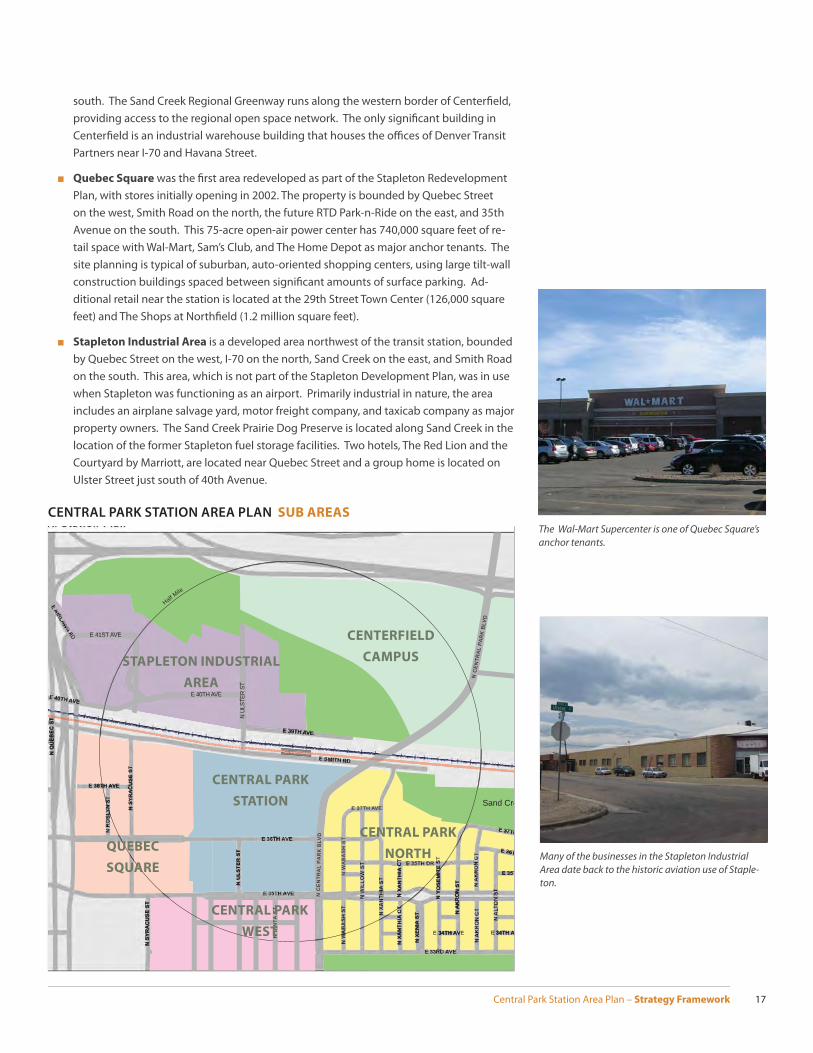
south. The Sand Creek Regional Greenway runs along the western border of Centerfi eld, providing access to the regional open space network. The only signifi cant building in Centerfi eld is an industrial warehouse building that houses the offi ces of Denver Transit Partners near I-70 and Havana Street.
■ Quebec Square was the fi rst area redeveloped as part of the Stapleton Redevelopment Plan, with stores initially opening in 2002. The property is bounded by Quebec Street on the west, Smith Road on the north, the future RTD Park-n-Ride on the east, and 35th Avenue on the south. This 75-acre open-air power center has 740,000 square feet of re-tail space with Wal-Mart, Sam’s Club, and The Home Depot as major anchor tenants. The site planning is typical of suburban, auto-oriented shopping centers, using large tilt-wall construction buildings spaced between signifi cant amounts of surface parking. Ad-ditional retail near the station is located at the 29th Street Town Center (126,000 square feet) and The Shops at Northfi eld (1.2 million square feet).
■ Stapleton Industrial Area is a developed area northwest of the transit station, bounded by Quebec Street on the west, I-70 on the north, Sand Creek on the east, and Smith Road on the south. This area, which is not part of the Stapleton Development Plan, was in use when Stapleton was functioning as an airport. Primarily industrial in nature, the area includes an airplane salvage yard, motor freight company, and taxicab company as major property owners. The Sand Creek Prairie Dog Preserve is located along Sand Creek in the location of the former Stapleton fuel storage facilities. Two hotels, The Red Lion and the Courtyard by Marriott, are located near Quebec Street and a group home is located on Ulster Street just south of 40th Avenue.
The Wal-Mart Supercenter is one of Quebec Square’s anchor tenants.
Many of the businesses in the Stapleton Industrial Area date back to the historic aviation use of Staple-ton.
TH
Park
Park
Employment
Park
Campus
Town Center
y
Industrial
Sand Cre
E 40TH AVE
E 39TH AVE
E 41ST AVED
C
Half Mile
E 34TH AVE E 34TH AV
E 37TH
E 36T
N U
LST
ER
ST
N X
AN
TH
IA C
TN
XA
NT
HIA
CT
N Y
OS
EM
ITE
ST
N A
KR
ON
ST
N X
EN
IA S
T
N W
AB
AS
H S
T
N C
EN
TR
AL
PA
RK
BLV
D
N C
EN
TRA
L P
AR
K B
LVD
N S
YR
AC
US
E S
T
N S
YR
AC
US
E S
T
N Q
UE
BE
C S
T
E 38TH AVE
E 37TH AVE
N U
LSTE
R S
T
N U
INT
A S
T
CENTRAL PARK
STATION
CENTERFIELD
CAMPUSSTAPLETON INDUSTRIAL
AREA
CENTRAL PARK
NORTH
CENTRAL PARK
WEST
QUEBEC
SQUARE
CENTRAL PARK STATION AREA PLAN SUB AREAS
Central Park Station Area Plan – Strategy Framework18
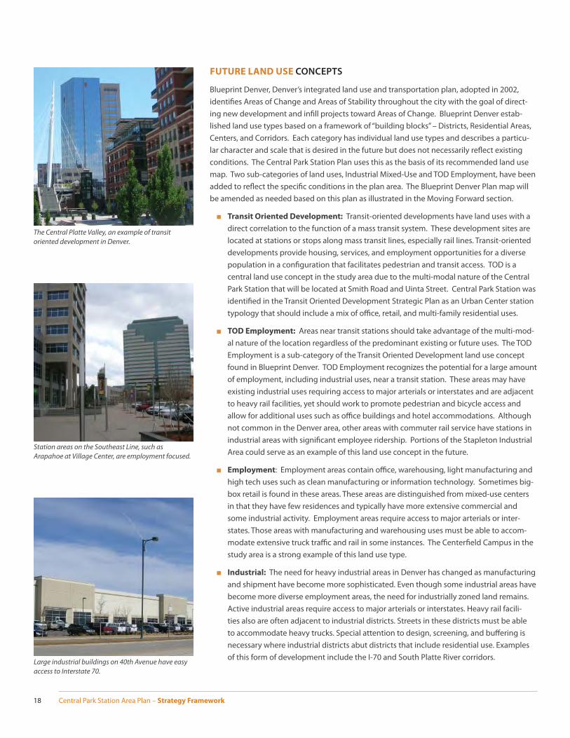
FUTURE LAND USE CONCEPTS
Blueprint Denver, Denver’s integrated land use and transportation plan, adopted in 2002, identifi es Areas of Change and Areas of Stability throughout the city with the goal of direct-ing new development and infi ll projects toward Areas of Change. Blueprint Denver estab-lished land use types based on a framework of “building blocks” – Districts, Residential Areas, Centers, and Corridors. Each category has individual land use types and describes a particu-lar character and scale that is desired in the future but does not necessarily refl ect existing conditions. The Central Park Station Plan uses this as the basis of its recommended land use map. Two sub-categories of land uses, Industrial Mixed-Use and TOD Employment, have been added to refl ect the specifi c conditions in the plan area. The Blueprint Denver Plan map will be amended as needed based on this plan as illustrated in the Moving Forward section.
■ Transit Oriented Development: Transit-oriented developments have land uses with a direct correlation to the function of a mass transit system. These development sites are located at stations or stops along mass transit lines, especially rail lines. Transit-oriented developments provide housing, services, and employment opportunities for a diverse population in a confi guration that facilitates pedestrian and transit access. TOD is a central land use concept in the study area due to the multi-modal nature of the Central Park Station that will be located at Smith Road and Uinta Street. Central Park Station was identifi ed in the Transit Oriented Development Strategic Plan as an Urban Center station typology that should include a mix of offi ce, retail, and multi-family residential uses.
■ TOD Employment: Areas near transit stations should take advantage of the multi-mod-al nature of the location regardless of the predominant existing or future uses. The TOD Employment is a sub-category of the Transit Oriented Development land use concept found in Blueprint Denver. TOD Employment recognizes the potential for a large amount of employment, including industrial uses, near a transit station. These areas may have existing industrial uses requiring access to major arterials or interstates and are adjacent to heavy rail facilities, yet should work to promote pedestrian and bicycle access and allow for additional uses such as offi ce buildings and hotel accommodations. Although not common in the Denver area, other areas with commuter rail service have stations in industrial areas with signifi cant employee ridership. Portions of the Stapleton Industrial Area could serve as an example of this land use concept in the future.
■ Employment: Employment areas contain offi ce, warehousing, light manufacturing and high tech uses such as clean manufacturing or information technology. Sometimes big-box retail is found in these areas. These areas are distinguished from mixed-use centers in that they have few residences and typically have more extensive commercial and some industrial activity. Employment areas require access to major arterials or inter-states. Those areas with manufacturing and warehousing uses must be able to accom-modate extensive truck traffi c and rail in some instances. The Centerfi eld Campus in the study area is a strong example of this land use type.
■ Industrial: The need for heavy industrial areas in Denver has changed as manufacturing and shipment have become more sophisticated. Even though some industrial areas have become more diverse employment areas, the need for industrially zoned land remains. Active industrial areas require access to major arterials or interstates. Heavy rail facili-ties also are often adjacent to industrial districts. Streets in these districts must be able to accommodate heavy trucks. Special attention to design, screening, and buff ering is necessary where industrial districts abut districts that include residential use. Examples of this form of development include the I-70 and South Platte River corridors.
Station areas on the Southeast Line, such as Arapahoe at Village Center, are employment focused.
The Central Platte Valley, an example of transit oriented development in Denver.
Large industrial buildings on 40th Avenue have easy access to Interstate 70.
Central Park Station Area Plan – Strategy Framework 19
T
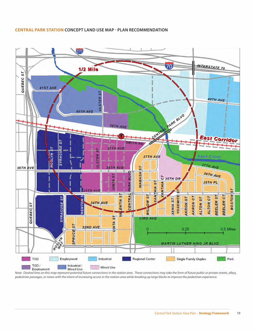
CENTRAL PARK STATION CONCEPT LAND USE MAP - PLAN RECOMMENDATION
Note: Dashed lines on this map represent potential future connections in the station area. These connections may take the form of future public or private streets, alleys, pedestrian passages, or mews with the intent of increasing access in the station area while breaking up large blocks to improve the pedestrian experience.

Central Park Station Area Plan – Strategy Framework20
■ Industrial Mixed-Use: Industrial Mixed-Use is a versatile land use concept, derived from Blueprint Denver’s Industrial land use concept, that recognizes that light industrial uses, such as light manufacturing and smaller warehouses are compatible with urban residen-tial housing types. These areas have both a sizable employment base as well as a variety of mid-to-high density housing options. Land uses can be, but are not necessarily, mixed in each building, development, or block. Pedestrian access is of importance within the area, with residential and non-residential uses always within walking distance of one another. The Stapleton Industrial Area, northwest of the future station location, has a mix of industrial uses and hotels and could accommodate some offi ce/employment uses as well as urban residential housing types as the TOD area matures.
■ Mixed-Use: In the context of this plan, there is one area designated for mixed-use, the RK Mechanical site. The existing light industrial use has been in its current location and is a permitted use in the existing C-MU-30 zone district. If a re-zoning is sought, mixed-use in this context would be primarily residential with the potential for a small amount of neighborhood serving retail. Any redevelopment plan should acknowledge the adjacent residential uses and utilize appropriate transitions.
■ Regional Center: Ideally, a regional center has a balance of retail, employment and resi-dential uses; however, many began as one major use, such as a regional shopping center or a large offi ce park. These centers cover a fairly large area and are dense enough to encompass both the dominant use and a wide variety of other uses. These centers have an atmosphere that is attractive to patrons from throughout the region. Quebec Square and the adjacent United Airlines training facility in Stapleton is an example of a regional center where a major shopping center is at the core of many other uses concentrated in a small area.
■ Single Family Duplex: Single family duplex residential areas are primarily residential with some complementary, small-scale commercial uses. There is a mixture of hous-ing types, including single-family houses, duplexes, rowhouses, and small apartment buildings. Typical densities are between 10 and 20 housing units per acre area-wide, and single family detached structures often predominate. Many historic neighborhoods contain this combination of housing types including City Park West, Alamo Placita, and portions of West Washington Park. Newer neighborhoods with this land use type, such as Cherry Creek, typically have a greater ratio of rowhouses and duplexes included in the housing mix.
■ Parks: Parks and natural open space are public spaces, ranging from highly pro-grammed parks to natural areas along the waterways. Parks and open spaces range from active neighborhood and community parks with recreation fi elds and centers to larger preserves of natural open areas that provide space for wildlife habitat. A “greenway” is a linear park or open space developed along a stream, canal, or other natural or man-made feature. They enhance nearby neighborhoods by providing park space and frequently off -street bicycle paths.
Single Family Duplex - Much of Stapleton has a mix of housing types, such as this Mansion style multi-family building that is integrated into what otherwise appears to be a completely single family residential area.
Industrial Mixed-Use can support a wide variety of building forms and business types.
Quebec Square is an example of a regional center

Central Park Station Area Plan – Strategy Framework 21
DESTINATION CONCEPTS AND RECOMMENDATIONS
■ A.1 High Intensity Development near the Station
The area nearest the station should have the greatest sense of urbanism of the entire Stapleton neighborhood:
▪ Allow taller general, shopfront, and apartment building forms with higher densities near the station.
▪ Allow a mix of uses within the area and within buildings with a emphasis on offi ce and multi-family development.
▪ Promote a high level of fl exibility, mixing uses to react to changing market condi-tions and encouraging the highest intensity of uses near the station.
▪ Through existing design review processes, encourage a wide mix of building heights and forms throughout the station area to provide visual interest, needed sunlight, and appropriate natural view corridors.
▪ Orient building forms and active ground fl oor uses towards the street with parking and vehicular access in the rear/off the alley.
▪ Identify opportunities to use mid-block passages that could take the form of public or private streets, alleys, or pedestrian paths to increase connectivity in the station area and break up large blocks.
▪ Capitalize on the delayed vertical construction of TOD on the RTD surface parking lots by seeking developers interested in high-density residential product types as the market matures in the station area. Residential development on RTD property should anticipate exceeding aff ordable housing goals set forth in the Stapleton Aff ordable Housing Plan.
E 36TH AVE
N C
ENTR
AL
PARK
BLV
D
E 35TH AVE
E 38TH AVE
E 39TH AVE
Half Mile
3 stories 5 stories 8 stories 12 stories 16 stories Transition Area
N
N S
YRA
CU
SE S
T
N X
ENIA
ST N
YO
SEM
ITE
ST
N X
AN
THIA
CT
E 40TH AVE
E 40TH AVE
E 40TH AVE
0 0.25 0.5 Miles
N U
LSTE
R ST
N U
INTA
ST
FUTURE BUILDING HEIGHTS CONCEPT MAP
Note: Dashed lines on this map represent potential future connections in the station area. These con-nections may take the form of future public or private streets, alleys, pedestrian passages, or mews with the intent of increasing access in the station area while breaking up large blocks to improve the pedestrian experience.
T
Mid-block connections improve pedestrian access in urban areas.
Higher Intensity development nearest the station is desired.
Central Park Station Area Plan – Strategy Framework22
“Big Box” retail can be integrated into a more pedes-trian scaled environment.
Apartment buildings with pedestrian-scaled elements on the ground fl oor can help transition from a mixed-use neighborhood to a residential neighborhood.
■ A.2 I-70 Employment Centers
Areas north of Smith Road and south of I-70 have strong access from both transit and automobiles, with a high level of visibility attractive to major employers:
▪ Allow a mix of general and industrial building forms north of Smith Road.
▪ Encourage an employment focus in the Centerfi eld Campus and the Stapleton Industrial Area to capitalize on the location’s high level of visibility.
▪ Promote infi ll development that enhances the built environment and capitalizes on the proximity to a passenger rail station while functioning next to existing industrial uses.
■ A.3 Infi ll Development at Appropriate Locations
Non-residential areas within the station area built at auto-oriented development intensities, such as Quebec Square, are candidates for future infi ll development:
▪ Allow general, shopfront, apartment, and industrial building forms compatible to existing uses.
▪ Infi ll development should reinforce the pedestrian nature of Stapleton at densities that support the high degree of nearby transit options.
▪ Large-scale infi ll development, such as within Quebec Square, should utilize varied building heights and design elements to establish a diverse built environment.
▪ Enhance mountain views from nearby public open space through careful site plan-ning and building orientation.
■ A.4. Establish Transitions to Residential Neighborhoods
A higher intensity of development is expected within the TOD site than nearby residen-tial neighborhoods. Appropriate transitions should occur at the edge of the TOD to ease from the mixed-use development pattern to the predominantly residential neighbor-hoods.
▪ Allow general, shopfront, and apartment building forms in transition areas.
▪ Locate residential building types at the edge of the TOD site with a height and scale that transitions between higher intensity building types in the TOD core and lower intensity development in existing residential neighborhoods.
▪ Make use of design elements, such as upper story setbacks, as necessary, to mini-mize massing adjacent to residential areas.
▪ Utilize major arterials, such as Central Park Boulevard and 35th Avenue, to ease transitions between mixed-use and residential neighborhoods.
▪ Promote the use of design elements that create a pedestrian scaled environment on streets that traverse between mixed-use and residential neighborhoods.
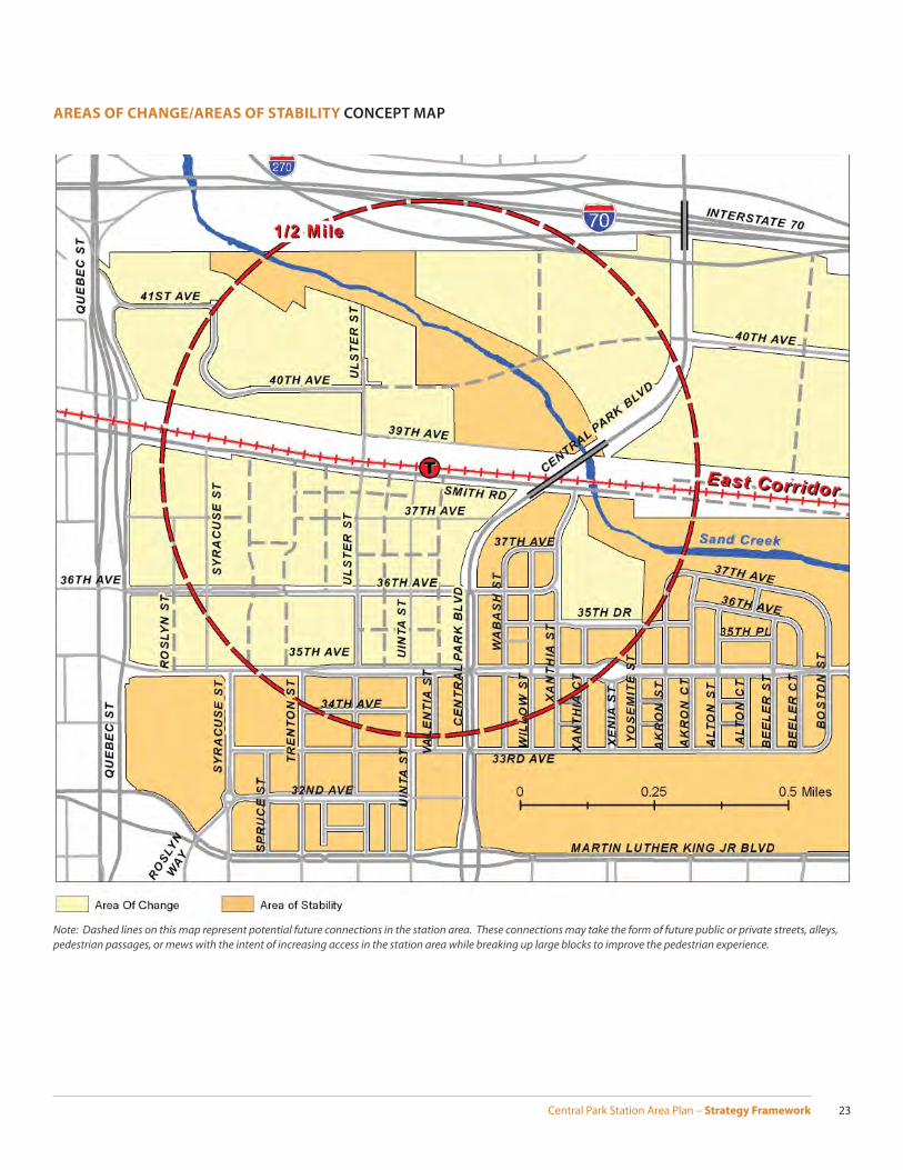
■ A.5. Change existing residential neighborhoods to Areas of Stability
Blueprint Denver, adopted in 2003, considers Stapleton as an area of change due to its status as a major redevelopment site. Since that time, the Central Park North neighbor-hood and the Central Park West neighborhood became substantially complete. Both residential areas should be Areas of Stability on Blueprint Denver Concept Land Use map. Station area parks and open space should also be considered Areas of Stability with the understanding that programing and activities will likely evolve over the plan horizon.
Existing Stapleton residential neighborhoods are now an area of stability.
Central Park Station Area Plan – Strategy Framework 23
AREAS OF CHANGE/AREAS OF STABILITY CONCEPT MAP
Note: Dashed lines on this map represent potential future connections in the station area. These connections may take the form of future public or private streets, alleys, pedestrian passages, or mews with the intent of increasing access in the station area while breaking up large blocks to improve the pedestrian experience.
Central Park Station Area Plan – Strategy Framework24
B. ActiveWHY IS BEING ACTIVE IMPORTANT TO THE CENTRAL PARK STATION AREA?
The Central Park Station expects a high level of activity due to its multi-modal nature, frequen-cy of service, and substantial projected ridership. The degree to which that activity extends out from the station will largely depend on the built environment and design of public spaces. Great urban neighborhoods are not places just to travel through but rather to stop, linger, converse, and generally live life. These activities happen in the public realm between build-ings – the streets and open space – framed by the built environment. The design and layout of development in the station area should seek to assemble people and activities through keeping distances for pedestrian travel and visual experiences as short as possible. The key public spaces need easy access to encourage people to move between the private and public environments of the station. Public spaces that integrate various activities and amenities in the station area increase the sense of activity. An active environment promotes a feeling of safety and visual interest for pedestrians by providing amenities such as outdoor seating areas, ground fl oor windows, cafes, accessible buildings, street trees, and other civic ameni-ties. As pedestrian activity increase in an area, offi ces, retail shops, and urban housing choices all become more viable.
SUMMARY OF EXISTING CONDITIONS
Since a large portion of the study area is undeveloped, there is a prevalent lack of active uses and amenities. Existing activity generators in the study area are limited to a few specifi c loca-tions and generally lack urban qualities. Quebec Square is the most active place within a half-mile of the station but is predominantly an auto-oriented suburban retail center challenged to provide a good pedestrian environment. The shopping center does respect elements of the Denver street grid, has detached sidewalks, and a number of the pad retail sites have buildings brought up to the street with outdoor patio seating. Considerable activity occurs at the current RTD Park-n-Ride and bus transfer facility near 36th Avenue and Uinta Street, but this facility will relocate by opening day to a location directly south of the commuter rail plat-form. Another activity generator, the FBI Building, utilizes a campus setting that limits street
PRINCIPLE STATEMENT
The station area will be a safe, vibrant, urban place that provides stimulating, enjoyable, and convenient activities and amenities for a wide variety of diff erent users.
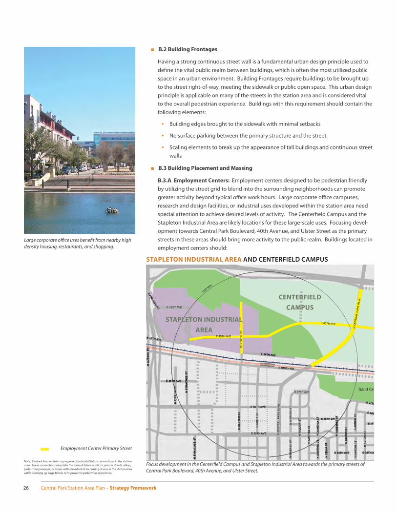
An active edge increases the visual and physical interaction between the public and private realm.
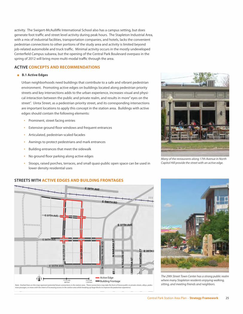
The 16th Street mall is a world-reknown pedestrian environment.
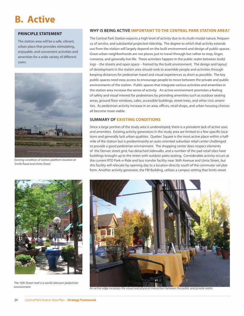
Existing condition of station platform location at Smith Road and Uinta Street.
Central Park Station Area Plan – Strategy Framework 25
activity. The Swigert-McAulliff e International School also has a campus setting, but does generate foot traffi c and street level activity during peak hours. The Stapleton Industrial Area, with a mix of industrial facilities, transportation companies, and hotels, lacks the convenient pedestrian connections to other portions of the study area and activity is limited beyond job-related automobile and truck traffi c. Minimal activity occurs in the mostly undeveloped Centerfi eld Campus subarea, but the opening of the Central Park Boulevard overpass in the spring of 2012 will bring more multi-modal traffi c through the area.
ACTIVE CONCEPTS AND RECOMMENDATIONS
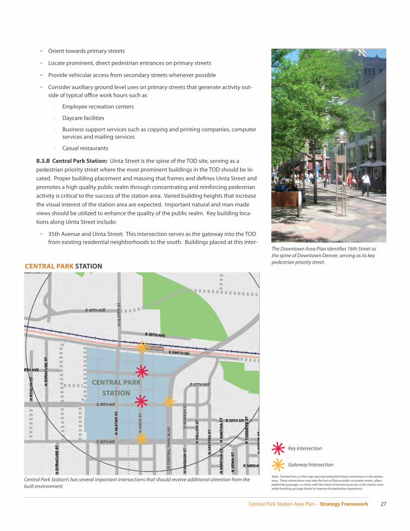
■ B.1 Active Edges
Urban neighborhoods need buildings that contribute to a safe and vibrant pedestrian environment. Promoting active edges on buildings located along pedestrian priority streets and key intersections adds to the urban experience, increases visual and physi-cal interaction between the public and private realm, and results in more” eyes on the street”. Uinta Street, as a pedestrian priority street, and its corresponding intersections are important locations to apply this concept in the station area. Buildings with active edges should contain the following elements:
▪ Prominent, street facing entries
▪ Extensive ground fl oor windows and frequent entrances
▪ Articulated, pedestrian-scaled facades
▪ Awnings to protect pedestrians and mark entrances
▪ Building entrances that meet the sidewalk
▪ No ground fl oor parking along active edges
▪ Stoops, raised porches, terraces, and small quasi-public open space can be used in lower density residential uses
Many of the restaurants along 17th Avenue in North Capitol Hill provide the street with an active edge.
The 29th Street Town Center has a strong public realm where many Stapleton residents enjoying walking, sitting, and meeting friends and neighbors.
STREETS WITH ACTIVE EDGES AND BUILDING FRONTAGES
E 37TH AVE
E 35TH AVE
N U
INTA
ST
N U
LSTE
R ST
N C
ENTR
AL
PARK
BLV
D
Active EdgeBuilding Frontage
N
0 0.25 mile1,320 feet
0.125 mile660 feet
E 36TH AVE
Note: Dashed lines on this map represent potential future connections in the station area. These connections may take the form of future public or private streets, alleys, pedes-trian passages, or mews with the intent of increasing access in the station area while breaking up large blocks to improve the pedestrian experience.
Central Park Station Area Plan – Strategy Framework26
Focus development in the Centerfi eld Campus and Stapleton Industrial Area towards the primary streets of Central Park Boulevard, 40th Avenue, and Ulster Street.
■ B.2 Building Frontages
Having a strong continuous street wall is a fundamental urban design principle used to defi ne the vital public realm between buildings, which is often the most utilized public space in an urban environment. Building Frontages require buildings to be brought up to the street right-of-way, meeting the sidewalk or public open space. This urban design principle is applicable on many of the streets in the station area and is considered vital to the overall pedestrian experience. Buildings with this requirement should contain the following elements:
▪ Building edges brought to the sidewalk with minimal setbacks
▪ No surface parking between the primary structure and the street
▪ Scaling elements to break up the appearance of tall buildings and continuous street walls
■ B.3 Building Placement and Massing
B.3.A Employment Centers: Employment centers designed to be pedestrian friendly by utilizing the street grid to blend into the surrounding neighborhoods can promote greater activity beyond typical offi ce work hours. Large corporate offi ce campuses, research and design facilities, or industrial uses developed within the station area need special attention to achieve desired levels of activity. The Centerfi eld Campus and the Stapleton Industrial Area are likely locations for these large-scale uses. Focusing devel-opment towards Central Park Boulevard, 40th Avenue, and Ulster Street as the primary streets in these areas should bring more activity to the public realm. Buildings located in employment centers should:
Large corporate offi ce uses benefi t from nearby high density housing, restaurants, and shopping.
TH
Park
Park
Employment
Park
Campus
Town Center
y
Industrial
Sand Cre
E 39TH AVE
E 41ST AVED
Half Mile
E 34TH AVE E 34TH AV
E 37TH
E 36T
N U
LST
ER
ST
N X
AN
TH
IA C
TN
XA
NT
HIA
CT
N Y
OS
EM
ITE
ST
N A
KR
ON
ST
N X
EN
IA S
T
N W
AB
AS
H S
T
N C
EN
TR
AL
PA
RK
BLV
D
N C
EN
TRA
L P
AR
K B
LVD
N S
YR
AC
US
E S
T
N S
YR
AC
US
E S
T
N Q
UE
BE
C S
T
E 38TH AVE
E 37TH AVE
N U
LSTE
R S
T
E 40TH AVE
E 40TH AVE
N U
INT
A S
T
CENTERFIELD
CAMPUS
STAPLETON INDUSTRIAL
AREA
Employment Center Primary Street
Note: Dashed lines on this map represent potential future connections in the station area. These connections may take the form of future public or private streets, alleys, pedestrian passages, or mews with the intent of increasing access in the station area while breaking up large blocks to improve the pedestrian experience.
STAPLETON INDUSTRIAL AREA AND CENTERFIELD CAMPUS
Central Park Station Area Plan – Strategy Framework 27
▪ Orient towards primary streets
▪ Locate prominent, direct pedestrian entrances on primary streets
▪ Provide vehicular access from secondary streets whenever possible
▪ Consider auxiliary ground level uses on primary streets that generate activity out-side of typical offi ce work hours such as
· Employee recreation centers
· Daycare facilities
· Business support services such as copying and printing companies, computer services and mailing services
· Casual restaurants
B.3.B Central Park Station: Uinta Street is the spine of the TOD site, serving as a pedestrian priority street where the most prominent buildings in the TOD should be lo-cated. Proper building placement and massing that frames and defi nes Uinta Street and promotes a high quality public realm through concentrating and reinforcing pedestrian activity is critical to the success of the station area. Varied building heights that increase the visual interest of the station area are expected. Important natural and man-made views should be utilized to enhance the quality of the public realm. Key building loca-tions along Uinta Street include:
▪ 35th Avenue and Uinta Street: This intersection serves as the gateway into the TOD from existing residential neighborhoods to the south. Buildings placed at this inter-
The Downtown Area Plan identifi es 16th Street as the spine of Downtown Denver, serving as its key pedestrian priority street.
E 35TH AVE
mployment Campus
Industrial
E 40TH AVE
E 39TH AVE
41ST AVE
E 34TH AV
N U
LST
ER
ST
N X
AN
TH
IA C
TN
XA
NT
HIA
CT
N Y
OS
EM
ITE
ST
NA
KR
ON
ST
N X
EN
IA S
T
N W
AB
AS
H S
T
N C
EN
TR
AL
PA
RK
BLV
D
N S
YR
AC
US
E S
T
N S
YR
AC
US
E S
T
8TH AVE
E 37TH AVE
N U
LSTE
R S
T
E 36TH AVE
N U
INT
A S
T
Central Park Station’s has several important intersections that should receive additional attention from the built environment.
CENTRAL PARK
STATION
Key Intersection
Gateway Intersection
Note: Dashed lines on this map represent potential future connections in the station area. These connections may take the form of future public or private streets, alleys, pedestrian passages, or mews with the intent of increasing access in the station area while breaking up large blocks to improve the pedestrian experience.
CENTRAL PARK STATION

Central Park Station Area Plan – Strategy Framework28
Some large shopping centers in the Denver metro region have been transformed into more walkable, mixed-use areas. Belmar in Lakewood is just one example.
section should utilize architectural elements that establish the intersection as a key entry point into the station area.
▪ 36th Avenue/37th Avenue and Uinta Street: Building placement and massing should recognize the prominence of these intersections as the heart of the TOD. Special corner treatments such as signature entries, special roof shapes, and taller, iconic architectural elements should be utilized.
▪ Smith Road and Uinta Street: This intersection serves as the gateway into the TOD from the station platform. Buildings placed at this intersection should have a strong visual presence from the station platform and be oriented towards both Uinta Street and Smith Road, establishing a clear and defi ned edge with the public right-of-way.
▪ 36th Avenue and Central Park Boulevard: This intersection serves as the gateway into the TOD from Central Park Boulevard. Buildings placed at this intersection should utilize architectural elements that establish the intersection as a key entry point into the station area.
B.3.C Quebec Square: The long-term redevelopment of Quebec Square is discussed as a Transformative Concept. If Quebec Square begins to experience infi ll development, building placement and massing considerations at specifi c locations should be utilized to increase activity levels throughout the area. Important natural and man-made views from public open space should be utilized to enhance the quality of the public realm. Key building locations in Quebec Square include:
▪ 36th Avenue and Quebec: Building placement and massing should recognize this as a gateway into Quebec Square by emphasizing the prominence of this intersection through appropriately composed architectural elements.
▪ Syracuse Street and Smith Road: Building placement and massing should recognize this as a gateway into Quebec Square by emphasizing the prominence of this inter-section through appropriately composed architectural elements.
TH
Employment Campus
Industrial
Single FamilyResidential
E 40TH AVE
E 39TH AVE
N U
LST
ER
ST
N W
AB
AS
H S
T
N C
EN
TR
AL
PA
RK
BLV
D
N S
YR
AC
US
E S
T
N S
YR
AC
US
E S
TN P
OP
LAR
ST
N Q
UE
BE
C S
T
E 38TH AVEE 38TH AVE
E SANDOWN RD
E 37TH AV
N U
LSTE
R S
T
N U
INT
A S
T
Quebec Square’s Gateway Intersections
QUEBEC
SQUARE
Gateway Intersection
QUEBEC SQUARE
Note: Dashed lines on this map represent potential future connections in the station area. These connections may take the form of future public or private streets, alleys, pedestrian passages, or mews with the intent of increasing access in the station area while breaking up large blocks to improve the pedestrian experience.
Central Park Station Area Plan – Strategy Framework 29
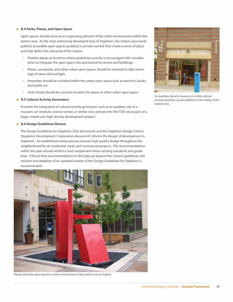
An auxiliary site of a museum or similar cultural activity would be a great addition to the vitality of the station area.
■ B.4 Parks, Plazas, and Open Space
Open spaces should serve as an organizing element of the urban environment within the station area. As the most intensively developed area of Stapleton, the station area needs publicly accessible open spaces (publicly or private owned) that create a sense of place and help defi ne the character of the station.
▪ Position plazas at locations where pedestrian activity is encouraged with consider-ation to integrate the open space into and bound by streets and buildings.
▪ Plazas, courtyards, and other urban open spaces should be oriented to take advan-tage of views and sunlight.
▪ Amenities should be included within the urban open space such as benches, kiosks, and public art.
▪ Uinta Street should be a priority location for plazas or other urban open space.
■ B.5 Cultural Activity Generators
Promote the integration of cultural activity generators such as an auxiliary site of a museum, art institute, science center, or similar civic venture into the TOD site as part of a larger, mixed-use, high density development project.
■ B.6 Design Guidelines Review
The Design Guidelines for Stapleton (City document) and the Stapleton Design Criteria (Stapleton Development Corporation document) informs the design of development in Stapleton. An established review process ensures high quality design throughout the neighborhood for all residential, retail, and commercial projects. The recommendations within this plan should reinforce and complement these existing standards and guide-lines. If found that recommendations in this plan go beyond the current guidelines, the revision and adoption of an updated version of the Design Guidelines for Stapleton is recommended.
Plazas and other open spaces in urban environments help create a sense of place.

Central Park Station Area Plan – Strategy Framework30
This hypothetical build-out scenario illustrates the Active Concepts and Recommendations. Buildings are brought up to the street, Uinta Street and intersections have ac-tive uses, and key intersections have prominent building forms.
Note: Some of the lines on this map represent potential future connections in the station area. These connections may take the form of future public or private streets, alleys, pedestrian passages, or mews with the intent of increasing access in the station area while breaking up large blocks to improve the pedestrian experience.
ACTIVE CONCEPTS AND RECOMMENDATIONS ILLUSTRATION

Central Park Station Area Plan – Strategy Framework 31
37th Avenue and Uinta Street will be at the heart of Central Park Station, providing Stapleton with a active, pedestrian friendly public realm surrounding by a mix of high intensity employment and high density residential uses.
UINTA STREET AND 37TH AVENUE

Central Park Station Area Plan – Strategy Framework32
C. AccessibleWHY IS BEING ACCESSIBLE IMPORTANT TO CENTRAL PARK STATION?
The relationship between mobility and access is essential in transportation planning. Mobility refers to the movement of people or goods. The term access implies reaching a location that has value, somewhere that provides a needed or desired amenity, service, or product. In the case of Central Park Station, the East Rail Line provides a high level of regional mobility, while the station functions as a portal, or a means of access, to a valued location such as Denver International Airport or Denver Union Station. This idea of access works in both directions; the East Line’s connection to DIA allows delivery of a world traveler to the station while a local resident can reach an airport with international destinations, all with relative ease. What is vi-tal for Central Park Station to thrive is the ability of the neighborhood surrounding the station to provide a high level of local, multi-modal mobility. This promotes strong local access to the station for the widest array of users. The ability to provide access to the station extends local and global connectivity to Stapleton and adjacent neighborhoods, resulting in higher levels of ridership and a greater amount of transit equity. Station accessibility increases the ability to leverage the signifi cant public investment of a commuter rail line to promote economic development and enhance the surrounding area’s quality of life.
SUMMARY OF EXISTING CONDITIONS
Current access to the future station location is diffi cult due to the lack of existing develop-ment near the site. The lack of connectivity from north to south across the Union Pacifi c Railroad right-of-way and I-70 and the incomplete street grid from east to west constitute the general access issues in the study area. Pedestrian and bicycle facilities vary with some signifi cant barriers existing on the edge of the study area.
■ Automobile Access: In its previous life as an International Airport, Stapleton required a signifi cant roadway network. I-70 and I-270 directed regional automobile traffi c from throughout the region to the area and arterial roadways built to accommodate high traf-fi c volumes fed into the airport. Much of this roadway network remains in place today. Major arterials in the study area include the existing six-lane confi gurations of Quebec Street and Martin Luther King Junior (MLK) Boulevard (between Quebec Street and Cen-tral Park Boulevard) that refl ect Stapleton’s past airport use. Smith Road currently does not extend past Sand Creek on the eastern side of the study area. Central Park Boulevard and 35th Avenue, two new four-lane roadways, were added to the street network as Stapleton redeveloped into a new neighborhood. An interchange at Central Park Sta-tion and I-70 opened in November 2011, and 40th Avenue now connects Central Park Boulevard with Havana Street to the east. These major streets provide the framework for automobile and truck traffi c in the station area today. The typical grid of local streets in Denver carries over into Stapleton, with the notable exception of Quebec Square, which mostly has private streets that only partially follow the Denver street pattern.
■ Bicycle and Pedestrian Access: The study areas varied land use mix of undeveloped land, newly completed residential neighborhoods, and auto-oriented shopping areas creates an inconsistent level of bicycle connections. The New Urbanism principles ap-plied to the redevelopment of Stapleton resulted in a bicycle friendly environment in the completed residential areas of the neighborhood. Quebec Square lacks the same level of bicycle facilities while the existing industrial area and the undeveloped area nearest to the station have little to no bicycle amenities. Bicycle lanes are located on Central Park Boulevard and 35th Avenue within the study area and on multiple routes near the study area, most notably on MLK Boulevard. The Sand Creek Regional Greenway provides an off -street bicycle path that connects to the larger regional bicycle network. Off -street paths are also located outside the study area in Central Park and along Westerly Creek. Bike Lanes on Central Park Boulevard
PRINCIPLE STATEMENT
The station area will build upon its regional connections to provide an extremely high level of mobility and multi-modal access for all users in a safe, easy, and convenient manner.
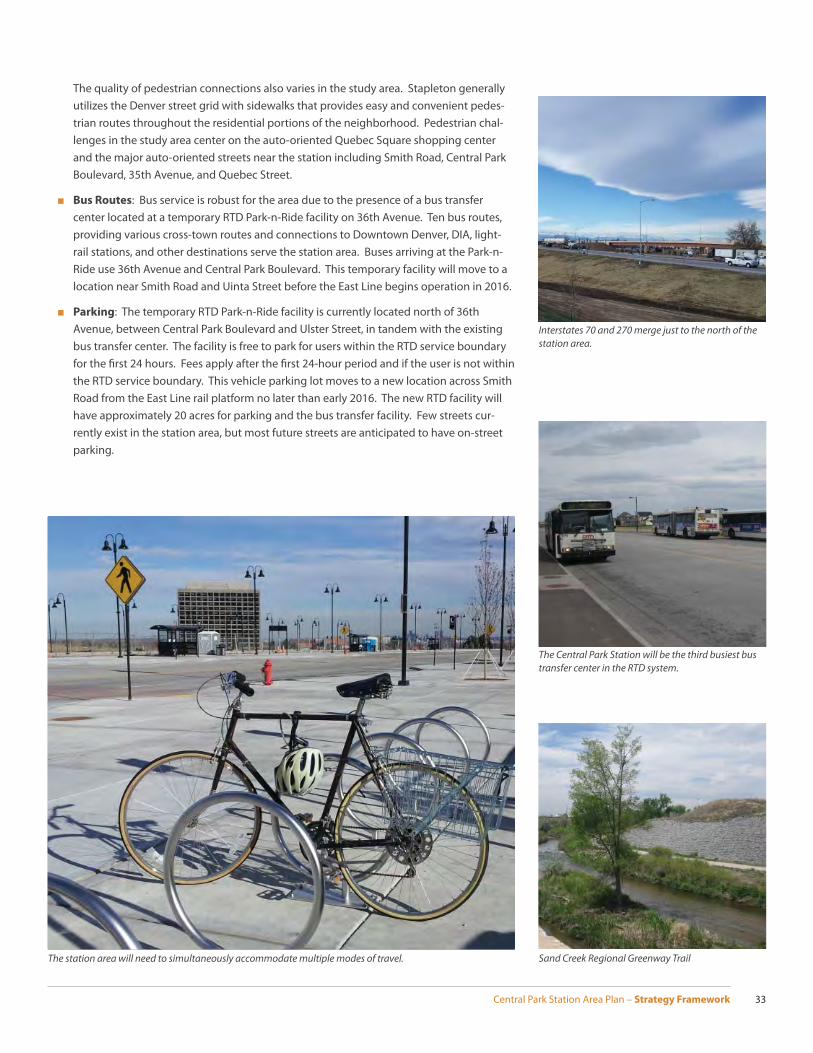
Central Park Station Area Plan – Strategy Framework 33
Interstates 70 and 270 merge just to the north of the station area.
The quality of pedestrian connections also varies in the study area. Stapleton generally utilizes the Denver street grid with sidewalks that provides easy and convenient pedes-trian routes throughout the residential portions of the neighborhood. Pedestrian chal-lenges in the study area center on the auto-oriented Quebec Square shopping center and the major auto-oriented streets near the station including Smith Road, Central Park Boulevard, 35th Avenue, and Quebec Street.
■ Bus Routes: Bus service is robust for the area due to the presence of a bus transfer center located at a temporary RTD Park-n-Ride facility on 36th Avenue. Ten bus routes, providing various cross-town routes and connections to Downtown Denver, DIA, light-rail stations, and other destinations serve the station area. Buses arriving at the Park-n-Ride use 36th Avenue and Central Park Boulevard. This temporary facility will move to a location near Smith Road and Uinta Street before the East Line begins operation in 2016.
■ Parking: The temporary RTD Park-n-Ride facility is currently located north of 36th Avenue, between Central Park Boulevard and Ulster Street, in tandem with the existing bus transfer center. The facility is free to park for users within the RTD service boundary for the fi rst 24 hours. Fees apply after the fi rst 24-hour period and if the user is not within the RTD service boundary. This vehicle parking lot moves to a new location across Smith Road from the East Line rail platform no later than early 2016. The new RTD facility will have approximately 20 acres for parking and the bus transfer facility. Few streets cur-rently exist in the station area, but most future streets are anticipated to have on-street parking.
The Central Park Station will be the third busiest bus transfer center in the RTD system.
Sand Creek Regional Greenway TrailThe station area will need to simultaneously accommodate multiple modes of travel.
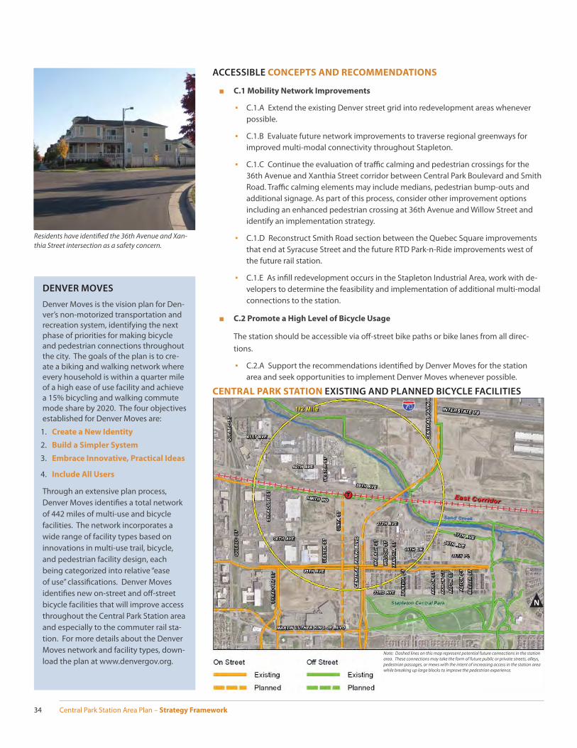
Central Park Station Area Plan – Strategy Framework34
ACCESSIBLE CONCEPTS AND RECOMMENDATIONS
■ C.1 Mobility Network Improvements
▪ C.1.A Extend the existing Denver street grid into redevelopment areas whenever possible.
▪ C.1.B Evaluate future network improvements to traverse regional greenways for improved multi-modal connectivity throughout Stapleton.
▪ C.1.C Continue the evaluation of traffi c calming and pedestrian crossings for the 36th Avenue and Xanthia Street corridor between Central Park Boulevard and Smith Road. Traffi c calming elements may include medians, pedestrian bump-outs and additional signage. As part of this process, consider other improvement options including an enhanced pedestrian crossing at 36th Avenue and Willow Street and identify an implementation strategy.
▪ C.1.D Reconstruct Smith Road section between the Quebec Square improvements that end at Syracuse Street and the future RTD Park-n-Ride improvements west of the future rail station.
▪ C.1.E As infi ll redevelopment occurs in the Stapleton Industrial Area, work with de-velopers to determine the feasibility and implementation of additional multi-modal connections to the station.
■ C.2 Promote a High Level of Bicycle Usage
The station should be accessible via off -street bike paths or bike lanes from all direc-tions.
▪ C.2.A Support the recommendations identifi ed by Denver Moves for the station area and seek opportunities to implement Denver Moves whenever possible.
Residents have identifi ed the 36th Avenue and Xan-thia Street intersection as a safety concern.
CENTRAL PARK STATION EXISTING AND PLANNED BICYCLE FACILITIES
N
Note: Dashed lines on this map represent potential future connections in the station area. These connections may take the form of future public or private streets, alleys, pedestrian passages, or mews with the intent of increasing access in the station area while breaking up large blocks to improve the pedestrian experience.
DENVER MOVES
Denver Moves is the vision plan for Den-ver’s non-motorized transportation and recreation system, identifying the next phase of priorities for making bicycle and pedestrian connections throughout the city. The goals of the plan is to cre-ate a biking and walking network where every household is within a quarter mile of a high ease of use facility and achieve a 15% bicycling and walking commute mode share by 2020. The four objectives established for Denver Moves are:
1. Create a New Identity
2. Build a Simpler System
3. Embrace Innovative, Practical Ideas
4. Include All Users
Through an extensive plan process, Denver Moves identifi es a total network of 442 miles of multi-use and bicycle facilities. The network incorporates a wide range of facility types based on innovations in multi-use trail, bicycle, and pedestrian facility design, each being categorized into relative “ease of use” classifi cations. Denver Moves identifi es new on-street and off -street bicycle facilities that will improve access throughout the Central Park Station area and especially to the commuter rail sta-tion. For more details about the Denver Moves network and facility types, down-load the plan at www.denvergov.org.
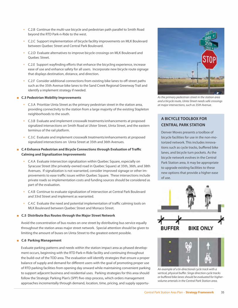
Central Park Station Area Plan – Strategy Framework 35
As the primary pedestrian street in the station area and a bicycle route, Uinta Street needs safe crossings at major intersections, such as 35th Avenue.
An example of a bi-directional cycle track with a vertical, physical buff er. Singe direction cycle tracks or buff ered bike lanes should be evaluated for higher-volume arterials in the Central Park Station area.
▪ C.2.B Continue the multi-use bicycle and pedestrian path parallel to Smith Road beyond the RTD Park-n-Ride to the west.
▪ C.2.C Support implementation of bicycle facility improvements on MLK Boulevard between Quebec Street and Central Park Boulevard.
▪ C.2.D Evaluate alternatives to improve bicycle crossings on MLK Boulevard and Quebec Street.
▪ C.2.E Support wayfi nding eff orts that enhance the bicycling experience, increase ease of use and enhance safety for all users. Incorporate new bicycle route signage that displays destination, distance, and direction.
▪ C.2.F Consider additional connections from existing bike lanes to off -street paths such as the 35th Avenue bike lanes to the Sand Creek Regional Greenway Trail and identify a implement strategy if needed.
■ C.3 Pedestrian Mobility Improvements
▪ C.3.A Prioritize Uinta Street as the primary pedestrian street in the station area, providing connectivity to the station from a large majority of the existing Stapleton neighborhoods to the south.
▪ C.3.B Evaluate and implement crosswalk treatments/enhancements at proposed signalized intersections on Smith Road at Ulster Street, Uinta Street, and the eastern terminus of the rail platform.
▪ C.3.C Evaluate and implement crosswalk treatments/enhancements at proposed signalized intersections on Uinta Street at 35th and 36th Avenues.
■ C.4 Enhance Pedestrian and Bicycle Connections through Evaluation of Traffi c
Calming and Signalization Improvements
▪ C.4.A Evaluate intersection signalization within Quebec Square, especially on Syracuse Street (the privately-owned road in Quebec Square) at 35th, 36th, and 38th Avenues. If signalization is not warranted, consider improved signage or other im-provements to ease traffi c issues within Quebec Square. These intersections include private roads so implementation costs and funding sources should be considered as part of the evaluation.
▪ C.4.B Continue to evaluate signalization of intersection at Central Park Boulevard and 33rd Street and implement as warranted.
▪ C.4.C Evaluate the need and potential implementation of traffi c calming tools on MLK Boulevard between Quebec Street and Monaco Street.
■ C.5 Distribute Bus Routes through the Major Street Network
Avoid the concentration of bus routes on one street by distributing bus service equally throughout the station areas major street network. Special attention should be given to limiting the amount of buses on Uinta Street to the greatest extent possible.
■ C.6 Parking Management
Evaluate parking patterns and needs within the station impact area as phased develop-ment occurs, beginning with the RTD Park-n-Ride facility and continuing throughout the build-out of the TOD area. The evaluation will identify strategies that ensure a proper balance of supply and demand for diff erent users with the goal of promoting proper use of RTD parking facilities from opening day onward while maintaining convenient parking to support adjacent business and residential uses. Parking strategies for this area should follow the Strategic Parking Plan’s (SPP) fi ve-step process, which orders management approaches incrementally through demand, location, time, pricing, and supply opportu-
A BICYCLE TOOLBOX FOR
CENTRAL PARK STATION
Denver Moves presents a toolbox of bicycle facilities for use in the non-mo-torized network. This includes innova-tions such as cycle tracks, buff ered bike lanes, and bicycle turn pockets. As the bicycle network evolves in the Central Park Station area, it may be appropriate to upgrade existing facilities to these new options that provide a higher ease of use.

Central Park Station Area Plan – Strategy Framework36
nities. This process coupled with stakeholder involvement will help determine the most eff ective parking management strategy for this area. Some strategies may include but are not limited to:
▪ Transportation Demand Management strategies including employer or community funded transit passes
▪ Shared or Accessory parking agreements between RTD, nearby multi-family, com-mercial, or offi ce uses. This includes opportunities to share off -street or structured parking inventory to reduce development costs. Subject to zoning approval.
▪ On-Street Time Limited Parking Restrictions
▪ Other parking management tools as outlined in the Strategic Parking Plan (SPP).
■ C.7 Street Cross Sections
Typical design considerations of the cross section recommendations are based on the City’s Rules and Regulations for Standard Right-of-Way Cross Sections. Bike lanes, shar-rows and other recommended enhancements to the City standards are proposed where relevant.
UINTA STREET MID-BLOCK
UINTA STREET
UINTA STREET Connecting existing Stapleton neighborhoods to the station through the heart of the TOD, Uinta should have two travel lanes, designated bike lanes, on-street parking on both sides of the street, and a large sidewalk and pedestrian amenity zone with street trees in grates.
At intersections, Uinta Street should have two travel lanes, a, left-turn lane, designated bike lanes, and a large sidewalk and pedestrian amenity zone with street trees in grates. On-street parking is lost as the turn lane is introduced.
STRATEGIC PARKING PLAN
The Strategic Parking Plan (SPP) identi-fi es a fi ve-step process coupled with stakeholder involvement to determine the most eff ective parking management
strategy for a specifi c area.
■ Demand
■ Location
■ Time
■ Pricing
■ Supply
The SPP was a joint eff ort of the City and County of Denver’s Public Works and Community Planning and Development Departments in 2010. The Plan can be found at www.denvergov.org/parking.
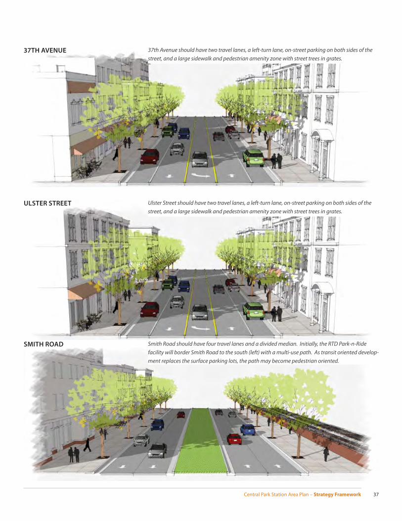
Central Park Station Area Plan – Strategy Framework 37
ULSTER STREET
37TH AVENUE
SMITH ROAD
37th Avenue should have two travel lanes, a left-turn lane, on-street parking on both sides of the street, and a large sidewalk and pedestrian amenity zone with street trees in grates.
Ulster Street should have two travel lanes, a left-turn lane, on-street parking on both sides of the street, and a large sidewalk and pedestrian amenity zone with street trees in grates.
Smith Road should have four travel lanes and a divided median. Initially, the RTD Park-n-Ride facility will border Smith Road to the south (left) with a multi-use path. As transit oriented develop-ment replaces the surface parking lots, the path may become pedestrian oriented.
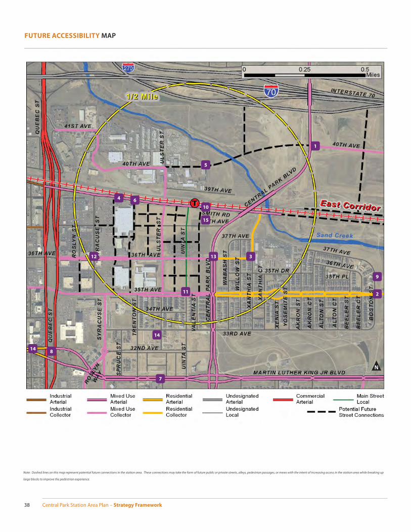
Central Park Station Area Plan – Strategy Framework38
FUTURE ACCESSIBILITY MAP
N
8
1
2
3
9
11
12 13
4
10
6
7
14
14
15
Note: Dashed lines on this map represent potential future connections in the station area. These connections may take the form of future public or private streets, alleys, pedestrian passages, or mews with the intent of increasing access in the station area while breaking up
large blocks to improve the pedestrian experience.
5
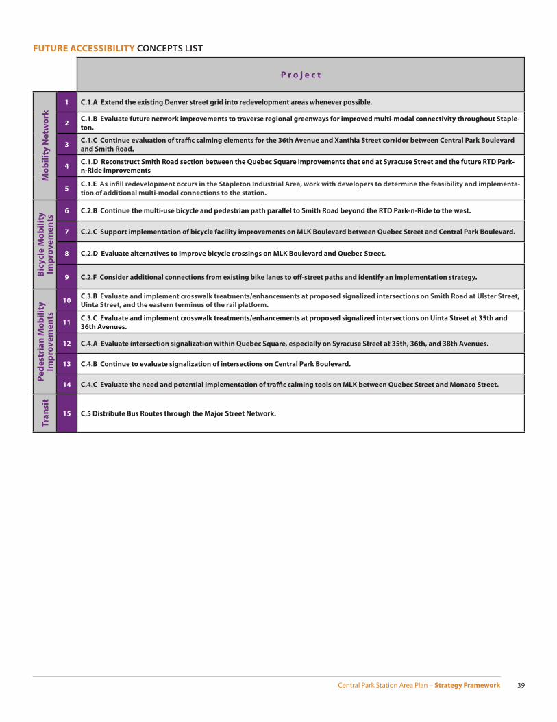
Central Park Station Area Plan – Strategy Framework 39
P r o j e c t
Mo
bil
ity
Ne
two
rk
1 C.1.A Extend the existing Denver street grid into redevelopment areas whenever possible.
2C.1.B Evaluate future network improvements to traverse regional greenways for improved multi-modal connectivity throughout Staple-
ton.
3C.1.C Continue evaluation of traffi c calming elements for the 36th Avenue and Xanthia Street corridor between Central Park Boulevard
and Smith Road.
4C.1.D Reconstruct Smith Road section between the Quebec Square improvements that end at Syracuse Street and the future RTD Park-
n-Ride improvements
5C.1.E As infi ll redevelopment occurs in the Stapleton Industrial Area, work with developers to determine the feasibility and implementa-
tion of additional multi-modal connections to the station.
Bic
yc
le M
ob
ilit
y
Imp
rov
em
en
ts
6 C.2.B Continue the multi-use bicycle and pedestrian path parallel to Smith Road beyond the RTD Park-n-Ride to the west.
7 C.2.C Support implementation of bicycle facility improvements on MLK Boulevard between Quebec Street and Central Park Boulevard.
8 C.2.D Evaluate alternatives to improve bicycle crossings on MLK Boulevard and Quebec Street.
9 C.2.F Consider additional connections from existing bike lanes to off -street paths and identify an implementation strategy.
Pe
de
stri
an
Mo
bil
ity
Im
pro
ve
me
nts
10C.3.B Evaluate and implement crosswalk treatments/enhancements at proposed signalized intersections on Smith Road at Ulster Street,
Uinta Street, and the eastern terminus of the rail platform.
11C.3.C Evaluate and implement crosswalk treatments/enhancements at proposed signalized intersections on Uinta Street at 35th and
36th Avenues.
12 C.4.A Evaluate intersection signalization within Quebec Square, especially on Syracuse Street at 35th, 36th, and 38th Avenues.
13 C.4.B Continue to evaluate signalization of intersections on Central Park Boulevard.
14 C.4.C Evaluate the need and potential implementation of traffi c calming tools on MLK between Quebec Street and Monaco Street.
Tra
nsi
t
15 C.5 Distribute Bus Routes through the Major Street Network.
FUTURE ACCESSIBILITY CONCEPTS LIST
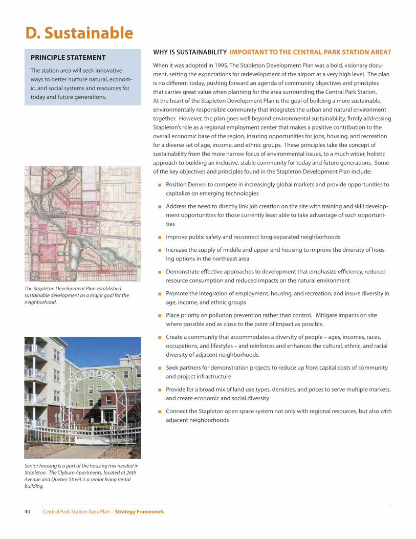
Central Park Station Area Plan – Strategy Framework40
D. SustainableWHY IS SUSTAINABILITY IMPORTANT TO THE CENTRAL PARK STATION AREA?
When it was adopted in 1995, The Stapleton Development Plan was a bold, visionary docu-ment, setting the expectations for redevelopment of the airport at a very high level. The plan is no diff erent today, pushing forward an agenda of community objectives and principles that carries great value when planning for the area surrounding the Central Park Station. At the heart of the Stapleton Development Plan is the goal of building a more sustainable, environmentally responsible community that integrates the urban and natural environment together. However, the plan goes well beyond environmental sustainability, fi rmly addressing Stapleton’s role as a regional employment center that makes a positive contribution to the overall economic base of the region, insuring opportunities for jobs, housing, and recreation for a diverse set of age, income, and ethnic groups. These principles take the concept of sustainability from the more narrow focus of environmental issues, to a much wider, holistic approach to building an inclusive, stable community for today and future generations. Some of the key objectives and principles found in the Stapleton Development Plan include:
■ Position Denver to compete in increasingly global markets and provide opportunities to capitalize on emerging technologies
■ Address the need to directly link job creation on the site with training and skill develop-ment opportunities for those currently least able to take advantage of such opportuni-ties
■ Improve public safety and reconnect long-separated neighborhoods
■ Increase the supply of middle and upper end housing to improve the diversity of hous-ing options in the northeast area
■ Demonstrate eff ective approaches to development that emphasize effi ciency, reduced resource consumption and reduced impacts on the natural environment
■ Promote the integration of employment, housing, and recreation, and insure diversity in age, income, and ethnic groups
■ Place priority on pollution prevention rather than control. Mitigate impacts on site where possible and as close to the point of impact as possible.
■ Create a community that accommodates a diversity of people – ages, incomes, races, occupations, and lifestyles – and reinforces and enhances the cultural, ethnic, and racial diversity of adjacent neighborhoods.
■ Seek partners for demonstration projects to reduce up front capital costs of community and project infrastructure
■ Provide for a broad mix of land use types, densities, and prices to serve multiple markets, and create economic and social diversity
■ Connect the Stapleton open space system not only with regional resources, but also with adjacent neighborhoods
The Stapleton Development Plan established sustainable development as a major goal for the neighborhood.
Senior housing is a part of the housing mix needed in Stapleton. The Clyburn Apartments, located at 26th Avenue and Quebec Street is a senior living rental building.
PRINCIPLE STATEMENT
The station area will seek innovative ways to better nurture natural, econom-ic, and social systems and resources for today and future generations.
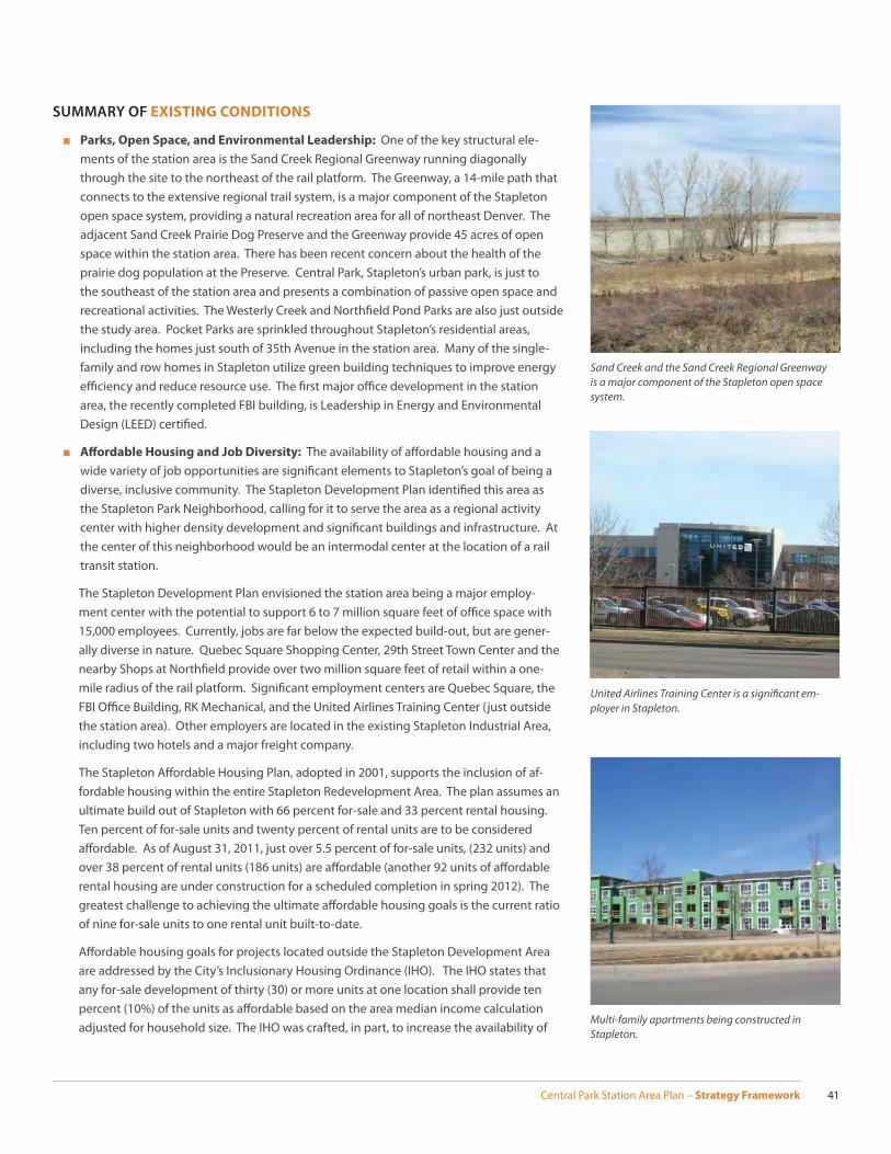
Central Park Station Area Plan – Strategy Framework 41
SUMMARY OF EXISTING CONDITIONS
■ Parks, Open Space, and Environmental Leadership: One of the key structural ele-ments of the station area is the Sand Creek Regional Greenway running diagonally through the site to the northeast of the rail platform. The Greenway, a 14-mile path that connects to the extensive regional trail system, is a major component of the Stapleton open space system, providing a natural recreation area for all of northeast Denver. The adjacent Sand Creek Prairie Dog Preserve and the Greenway provide 45 acres of open space within the station area. There has been recent concern about the health of the prairie dog population at the Preserve. Central Park, Stapleton’s urban park, is just to the southeast of the station area and presents a combination of passive open space and recreational activities. The Westerly Creek and Northfi eld Pond Parks are also just outside the study area. Pocket Parks are sprinkled throughout Stapleton’s residential areas, including the homes just south of 35th Avenue in the station area. Many of the single-family and row homes in Stapleton utilize green building techniques to improve energy effi ciency and reduce resource use. The fi rst major offi ce development in the station area, the recently completed FBI building, is Leadership in Energy and Environmental Design (LEED) certifi ed.
■ Aff ordable Housing and Job Diversity: The availability of aff ordable housing and a wide variety of job opportunities are signifi cant elements to Stapleton’s goal of being a diverse, inclusive community. The Stapleton Development Plan identifi ed this area as the Stapleton Park Neighborhood, calling for it to serve the area as a regional activity center with higher density development and signifi cant buildings and infrastructure. At the center of this neighborhood would be an intermodal center at the location of a rail transit station.
The Stapleton Development Plan envisioned the station area being a major employ-ment center with the potential to support 6 to 7 million square feet of offi ce space with 15,000 employees. Currently, jobs are far below the expected build-out, but are gener-ally diverse in nature. Quebec Square Shopping Center, 29th Street Town Center and the nearby Shops at Northfi eld provide over two million square feet of retail within a one-mile radius of the rail platform. Signifi cant employment centers are Quebec Square, the FBI Offi ce Building, RK Mechanical, and the United Airlines Training Center (just outside the station area). Other employers are located in the existing Stapleton Industrial Area, including two hotels and a major freight company.
The Stapleton Aff ordable Housing Plan, adopted in 2001, supports the inclusion of af-fordable housing within the entire Stapleton Redevelopment Area. The plan assumes an ultimate build out of Stapleton with 66 percent for-sale and 33 percent rental housing. Ten percent of for-sale units and twenty percent of rental units are to be considered aff ordable. As of August 31, 2011, just over 5.5 percent of for-sale units, (232 units) and over 38 percent of rental units (186 units) are aff ordable (another 92 units of aff ordable rental housing are under construction for a scheduled completion in spring 2012). The greatest challenge to achieving the ultimate aff ordable housing goals is the current ratio of nine for-sale units to one rental unit built-to-date.
Aff ordable housing goals for projects located outside the Stapleton Development Area are addressed by the City’s Inclusionary Housing Ordinance (IHO). The IHO states that any for-sale development of thirty (30) or more units at one location shall provide ten percent (10%) of the units as aff ordable based on the area median income calculation adjusted for household size. The IHO was crafted, in part, to increase the availability of
United Airlines Training Center is a signifi cant em-ployer in Stapleton.
Multi-family apartments being constructed in Stapleton.
Sand Creek and the Sand Creek Regional Greenway is a major component of the Stapleton open space system.
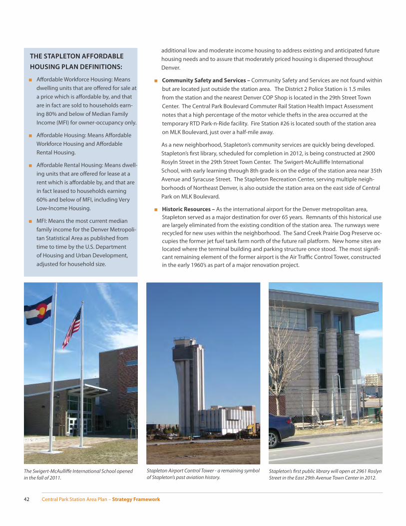
Central Park Station Area Plan – Strategy Framework42
additional low and moderate income housing to address existing and anticipated future housing needs and to assure that moderately priced housing is dispersed throughout Denver.
■ Community Safety and Services – Community Safety and Services are not found within but are located just outside the station area. The District 2 Police Station is 1.5 miles from the station and the nearest Denver COP Shop is located in the 29th Street Town Center. The Central Park Boulevard Commuter Rail Station Health Impact Assessment notes that a high percentage of the motor vehicle thefts in the area occurred at the temporary RTD Park-n-Ride facility. Fire Station #26 is located south of the station area on MLK Boulevard, just over a half-mile away.
As a new neighborhood, Stapleton’s community services are quickly being developed. Stapleton’s fi rst library, scheduled for completion in 2012, is being constructed at 2900 Rosyln Street in the 29th Street Town Center. The Swigert-McAulliff e International School, with early learning through 8th grade is on the edge of the station area near 35th Avenue and Syracuse Street. The Stapleton Recreation Center, serving multiple neigh-borhoods of Northeast Denver, is also outside the station area on the east side of Central Park on MLK Boulevard.
■ Historic Resources – As the international airport for the Denver metropolitan area, Stapleton served as a major destination for over 65 years. Remnants of this historical use are largely eliminated from the existing condition of the station area. The runways were recycled for new uses within the neighborhood. The Sand Creek Prairie Dog Preserve oc-cupies the former jet fuel tank farm north of the future rail platform. New home sites are located where the terminal building and parking structure once stood. The most signifi -cant remaining element of the former airport is the Air Traffi c Control Tower, constructed in the early 1960’s as part of a major renovation project.
THE STAPLETON AFFORDABLE
HOUSING PLAN DEFINITIONS:
■ Aff ordable Workforce Housing: Means dwelling units that are off ered for sale at a price which is aff ordable by, and that are in fact are sold to households earn-ing 80% and below of Median Family Income (MFI) for owner-occupancy only.
■ Aff ordable Housing: Means Aff ordable Workforce Housing and Aff ordable Rental Housing.
■ Aff ordable Rental Housing: Means dwell-ing units that are off ered for lease at a rent which is aff ordable by, and that are in fact leased to households earning 60% and below of MFI, including Very Low-Income Housing.
■ MFI: Means the most current median family income for the Denver Metropoli-tan Statistical Area as published from time to time by the U.S. Department of Housing and Urban Development, adjusted for household size.
Stapleton Airport Control Tower - a remaining symbol of Stapleton’s past aviation history.
The Swigert-McAulliff e International School opened in the fall of 2011.
Stapleton’s fi rst public library will open at 2961 Roslyn Street in the East 29th Avenue Town Center in 2012.
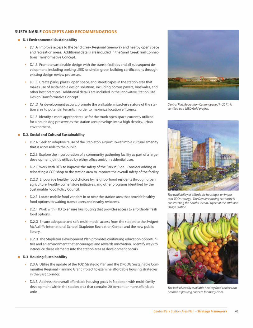
Central Park Station Area Plan – Strategy Framework 43
SUSTAINABLE CONCEPTS AND RECOMMENDATIONS
■ D.1 Environmental Sustainability
▪ D.1.A Improve access to the Sand Creek Regional Greenway and nearby open space and recreation areas. Additional details are included in the Sand Creek Trail Connec-tions Transformative Concept.
▪ D.1.B Promote sustainable design with the transit facilities and all subsequent de-velopment, including seeking LEED or similar green building certifi cations through existing design review processes.
▪ D.1.C Create parks, plazas, open space, and streetscapes in the station area that makes use of sustainable design solutions, including porous pavers, bioswales, and other best practices. Additional details are included in the Innovative Station Site Design Transformative Concept.
▪ D.1.D As development occurs, promote the walkable, mixed-use nature of the sta-tion area to potential tenants in order to maximize location effi ciency.
▪ D.1.E Identify a more appropriate use for the trunk open space currently utilized for a prairie dog preserve as the station area develops into a high density, urban environment.
■ D.2. Social and Cultural Sustainability
▪ D.2.A Seek an adaptive reuse of the Stapleton Airport Tower into a cultural amenity that is accessible to the public.
▪ D.2.B Explore the incorporation of a community gathering facility as part of a larger development jointly utilized by either offi ce and/or residential uses.
▪ D.2.C Work with RTD to improve the safety of the Park-n-Ride. Consider adding or relocating a COP shop to the station area to improve the overall safety of the facility.
▪ D.2.D Encourage healthy food choices by neighborhood residents through urban agriculture, healthy corner store initiatives, and other programs identifi ed by the Sustainable Food Policy Council.
▪ D.2.E Locate mobile food vendors in or near the station area that provide healthy food options to waiting transit users and nearby residents.
▪ D.2.F Work with RTD to ensure bus routing that provides access to aff ordable fresh food options.
▪ D.2.G Ensure adequate and safe multi-modal access from the station to the Swigert-McAulliff e International School, Stapleton Recreation Center, and the new public library.
▪ D.2.H The Stapleton Development Plan promotes continuing education opportuni-ties and an environment that encourages and rewards innovation. Identify ways to introduce these elements into the station area as development occurs.
■ D.3 Housing Sustainability
▪ D.3.A Utilize the update of the TOD Strategic Plan and the DRCOG Sustainable Com-munities Regional Planning Grant Project to examine aff ordable housing strategies in the East Corridor.
▪ D.3.B Address the overall aff ordable housing goals in Stapleton with multi-family development within the station area that contains 20 percent or more aff ordable units.
The availability of aff ordable housing is an impor-tant TOD strategy. The Denver Housing Authority is constructing the South Lincoln Project at the 10th and Osage Station.
Central Park Recreation Center opened in 2011, is certifi ed as a LEED Gold project.
The lack of readily available healthy food choices has become a growing concern for many cities.
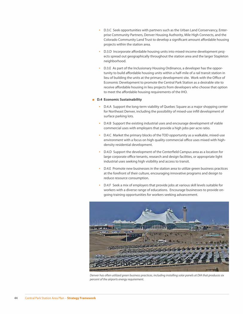
Central Park Station Area Plan – Strategy Framework44
▪ D.3.C Seek opportunities with partners such as the Urban Land Conservancy, Enter-prise Community Partners, Denver Housing Authority, Mile High Connects, and the Colorado Community Land Trust to develop a signifi cant amount aff ordable housing projects within the station area.
▪ D.3.D Incorporate aff ordable housing units into mixed-income development proj-ects spread out geographically throughout the station area and the larger Stapleton neighborhood.
▪ D.3.E As part of the Inclusionary Housing Ordinance, a developer has the oppor-tunity to build aff ordable housing units within a half-mile of a rail transit station in lieu of building the units at the primary development site. Work with the Offi ce of Economic Development to promote the Central Park Station as a desirable site to receive aff ordable housing in lieu projects from developers who choose that option to meet the aff ordable housing requirements of the IHO.
■ D.4 Economic Sustainability
▪ D.4.A Support the long-term viability of Quebec Square as a major shopping center for Northeast Denver, including the possibility of mixed-use infi ll development of surface parking lots.
▪ D.4.B Support the existing industrial uses and encourage development of viable commercial uses with employers that provide a high jobs-per-acre ratio.
▪ D.4.C Market the primary blocks of the TOD opportunity as a walkable, mixed-use environment with a focus on high quality commercial offi ce uses mixed with high-density residential development.
▪ D.4.D Support the development of the Centerfi eld Campus area as a location for large corporate offi ce tenants, research and design facilities, or appropriate light industrial uses seeking high visibility and access to transit.
▪ D.4.E Promote new businesses in the station area to utilize green business practices at the forefront of their culture, encouraging innovative programs and design to reduce resource consumption.
▪ D.4.F Seek a mix of employers that provide jobs at various skill levels suitable for workers with a diverse range of educations. Encourage businesses to provide on-going training opportunities for workers seeking advancement.
Denver has often utilized green business practices, including installing solar panels at DIA that produces six percent of the airports energy requirement.

Central Park Station Area Plan – Strategy Framework 45
PROMOTING HEALTHY LIFESTYLES
Central Park Station is a great opportunity to encourage nearby neighborhood residents to make choices that result in a healthier lifestyle. Local offi cials across the country are becoming increasingly aware of how the built environment aff ects the health and infl u-ences the lifestyle choices of residents. Many major U.S. cities are taking great strides to make choosing a healthy lifestyle easier for their residents. Promoting a healthy lifestyle is at the heart of many of Central Park Station Area Plan recommendations. A few ex-amples include:
■ Pedestrian friendly streets and crosswalk treatments
■ Improved bicycle access and promotion of bicycle sharing and rental programs
■ Building design that promotes an active, walkable, urban neighborhood
■ Locating healthy food vendors at the station for commuters and residents
■ Greater connectivity between on-street bicycle facilities, the Sand Creek Regional Green-way Trail, and corresponding recreational opportunities
■ Extension of the Denver street grid into redevelopment areas whenever possible
■ The Stapleton TMA will lead the eff ort to develop an Intermodal Transportation Center at the station that centralizes and coordinates multiple mobility options
As development occurs within the station area, attention should be given to crafting the public realm in a way that encourages and supports integrated exercise opportunities, making exercise access easier and a part of the neighborhoods daily activity. This in-cludes providing access to parks, plazas, open space, streetscapes, and other recreational opportunities throughout the station area.
The Stapleton Foundation, Stapleton Transportation Management Association, and BeWell Stapleton will utilize the Central Park Station Area Plan and the associated Health Impact Assessment to promote healthy lifestyle choices in Stapleton and surrounding neighborhoods and work to identify funding sources to implement both of the plans health-related recommendations.
A high quality bicycle network is one way that the built environment can promote healthy lifestyle choices.

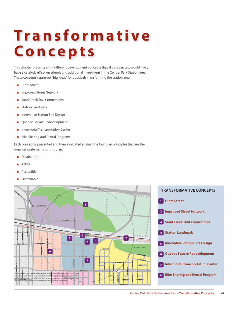
Central Park Show Station Area Plan – Transformative Concepts 47
Tr a n s f o r m a t i v e C o n c e p t sThis chapter presents eight diff erent development concepts that, if constructed, would likely have a catalytic eff ect on stimulating additional investment in the Central Park Station area. These concepts represent “big ideas” for positively transforming the station area:
■ Uinta Street
■ Improved Street Network
■ Sand Creek Trail Connections
■ Station Landmark
■ Innovative Station Site Design
■ Quebec Square Redevelopment
■ Intermodal Transportation Center
■ Bike Sharing and Rental Programs
Each concept is presented and then evaluated against the four plan principles that are the organizing elements for this plan:
■ Destination
■ Active
■ Accessible
■ Sustainable
Park
Park
Park
Employment
Park
Campus
Industrial
Single FamilyResidential
Industrial
Sand Creek
E 40TH AVE
E 39TH AVE
E 41ST AVED
Half Mile
E 34TH AVE E 34TH AVE
E 37TH AVE
E 36TH AVE
N X
AN
TH
IA C
TN
XA
NT
HIA
CT
N Y
OS
EM
ITE
ST
N A
KR
ON
ST
N X
EN
IA S
T
N W
AB
AS
H S
T
N C
EN
TR
AL
PA
RK
BLV
D
N C
EN
TR
AL
PA
RK
BLV
D
N S
YR
AC
US
E S
T
N P
OP
LAR
ST
N Q
UE
BE
C S
T
E 38TH AVEE 38TH AVE
E SANDOWN RD
E 37TH AVE
N U
LSTE
R S
T
UIN
TA
ST
N U
INT
A S
T
E 36TH AVE
N U
LST
ER
ST
N S
YR
AC
US
E S
T
TRANSFORMATIVE CONCEPTS
1. Uinta Street
2. Improved Street Network
3. Sand Creek Trail Connections
4. Station Landmark
5. Innovative Station Site Design
6. Quebec Square Redevelopment
7. Intermodal Transportation Center
8. Bike Sharing and Rental Program
44
1
1
2
2
3
3
8
8
5
57
7
66
Note: Dashed lines on this map represent potential future connections in the station area. These connections may take the form of future public or private streets, alleys, pedestrian passages, or mews with the intent of increasing access in the station area while breaking up large blocks to improve the pedestrian experience.
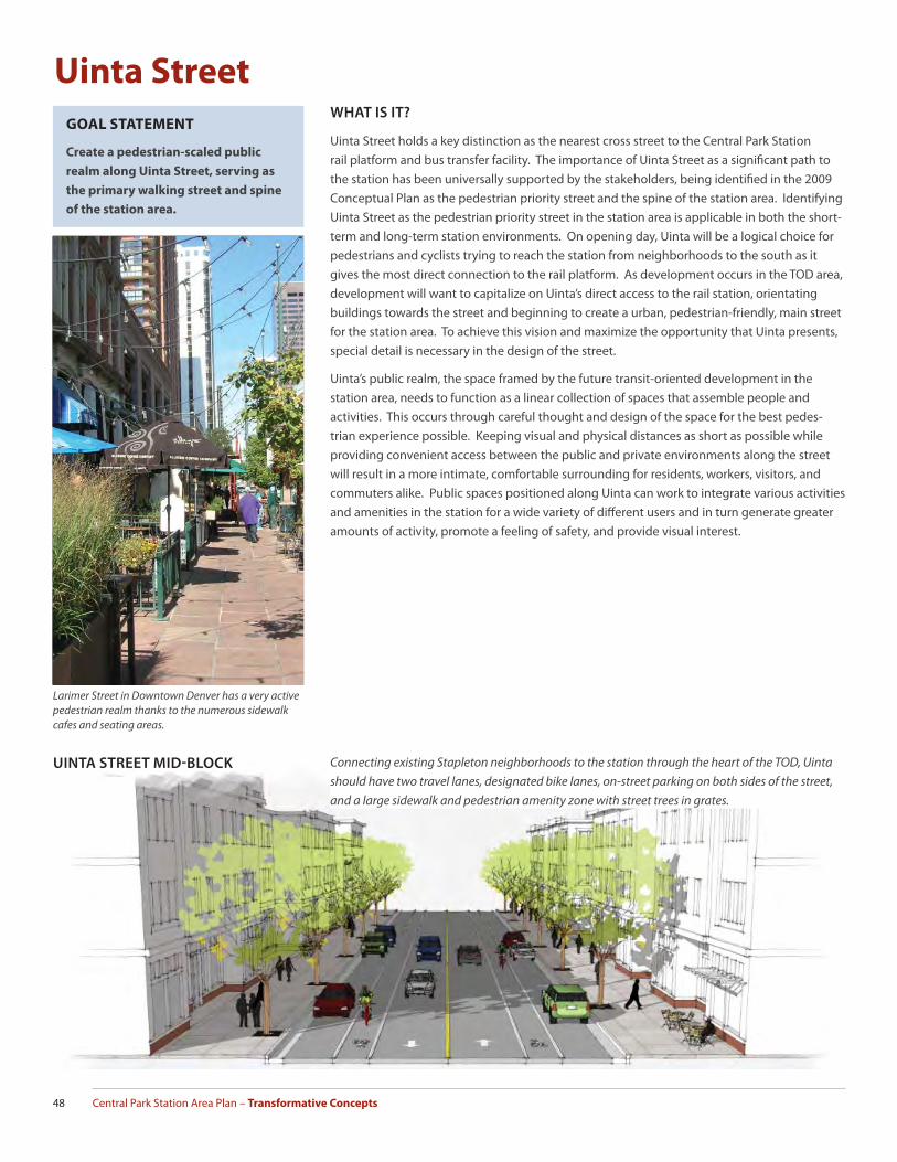
Central Park Station Area Plan – Transformative Concepts48
Uinta Street
Larimer Street in Downtown Denver has a very active pedestrian realm thanks to the numerous sidewalk cafes and seating areas.
GOAL STATEMENT
Create a pedestrian-scaled public
realm along Uinta Street, serving as
the primary walking street and spine
of the station area.
WHAT IS IT?
Uinta Street holds a key distinction as the nearest cross street to the Central Park Station rail platform and bus transfer facility. The importance of Uinta Street as a signifi cant path to the station has been universally supported by the stakeholders, being identifi ed in the 2009 Conceptual Plan as the pedestrian priority street and the spine of the station area. Identifying Uinta Street as the pedestrian priority street in the station area is applicable in both the short-term and long-term station environments. On opening day, Uinta will be a logical choice for pedestrians and cyclists trying to reach the station from neighborhoods to the south as it gives the most direct connection to the rail platform. As development occurs in the TOD area, development will want to capitalize on Uinta’s direct access to the rail station, orientating buildings towards the street and beginning to create a urban, pedestrian-friendly, main street for the station area. To achieve this vision and maximize the opportunity that Uinta presents, special detail is necessary in the design of the street.
Uinta’s public realm, the space framed by the future transit-oriented development in the station area, needs to function as a linear collection of spaces that assemble people and activities. This occurs through careful thought and design of the space for the best pedes-trian experience possible. Keeping visual and physical distances as short as possible while providing convenient access between the public and private environments along the street will result in a more intimate, comfortable surrounding for residents, workers, visitors, and commuters alike. Public spaces positioned along Uinta can work to integrate various activities and amenities in the station for a wide variety of diff erent users and in turn generate greater amounts of activity, promote a feeling of safety, and provide visual interest.
UINTA STREET MID-BLOCK Connecting existing Stapleton neighborhoods to the station through the heart of the TOD, Uinta should have two travel lanes, designated bike lanes, on-street parking on both sides of the street, and a large sidewalk and pedestrian amenity zone with street trees in grates.

Central Park Show Station Area Plan – Transformative Concepts 49
Outdoor seating areas help to promote a safe and visually interesting pedestrian experience.
HOW DOES UINTA STREET ADDRESS BEING A DESTINATION?
■ Uinta Street has the opportunity to be the main street of the station area, providing residents and visitors a high quality public realm, becoming the focal axis of the transit oriented development.
HOW DOES UINTA STREET ADDRESS BEING ACTIVE?
■ The urban design of buildings and streetscapes along Uinta should encourage pedes-trian activity and promote community gathering.
■ Uinta Street should provide a safe and visually interesting pedestrian experience through amenities such as outdoor seating areas, ground fl oor windows, cafes, accessible ser-vices, and street trees.
HOW DOES UINTA STREET ADDRESS BEING ACCESSIBLE?
■ Uinta Street will serve as a multi-modal street, providing access to pedestrians, bicyclists, and motorists. Special attention should be given to establishing Uinta as the pedestrian priority street in the station area.
HOW DOES UINTA STREET ADDRESS BEING SUSTAINABLE?
■ Uinta Street promotes alternative modes of transportation, potentially reducing vehicle miles traveled, reducing traffi c congestion and improving air quality.
■ The design of Uinta’s public realm can strive to improve water quality and reduce water runoff by incorporating sustainable best practices in urban design and streetscapes.
Small, intimate, publicly accessible open space can help create a sense of place within the station area.
UINTA STREET INTERSECTION At intersections, Uinta Street should have two travel lanes, a, left-turn lane when traffi c levels de-mand, designated bike lanes, and a large sidewalk and pedestrian amenity zone with street trees in grates. On-street parking is lost as the turn lane is introduced.

Central Park Station Area Plan – Transformative Concepts50
KEY ASPECTS OF UINTA’S PUBLIC
REALM
■ Active Edges
■ Building Frontages
■ Crossings on Smith Road
■ Crossings at 35th and 36th Ave
■ Plaza and Open Space
■ Gateway - 35th Ave
■ Key Building Location - 36th Ave
■ Key Building Location - 37th Ave
■ Gateway - Smith Road
■ Bike Lanes
■ On-street parking
■ Minimize Bus Traffi c
4
2
23
8
8
5
7
7
6
6
12
12
9
9
1111
1
1
10
10
3
5
4
Note: Some lines on this map represent potential future connections in the station area. These connections may take the form of future public or private streets, alleys, pedestrian passages, or mews with the intent of increasing access in the station area while breaking up large blocks to improve the pedestrian experience.
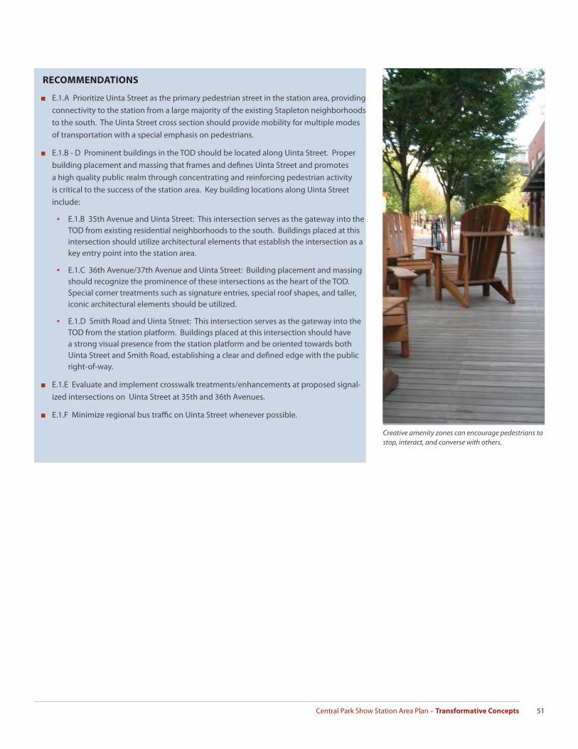
Central Park Show Station Area Plan – Transformative Concepts 51
RECOMMENDATIONS
■ E.1.A Prioritize Uinta Street as the primary pedestrian street in the station area, providing connectivity to the station from a large majority of the existing Stapleton neighborhoods to the south. The Uinta Street cross section should provide mobility for multiple modes of transportation with a special emphasis on pedestrians.
■ E.1.B - D Prominent buildings in the TOD should be located along Uinta Street. Proper building placement and massing that frames and defi nes Uinta Street and promotes a high quality public realm through concentrating and reinforcing pedestrian activity is critical to the success of the station area. Key building locations along Uinta Street include:
▪ E.1.B 35th Avenue and Uinta Street: This intersection serves as the gateway into the TOD from existing residential neighborhoods to the south. Buildings placed at this intersection should utilize architectural elements that establish the intersection as a key entry point into the station area.
▪ E.1.C 36th Avenue/37th Avenue and Uinta Street: Building placement and massing should recognize the prominence of these intersections as the heart of the TOD. Special corner treatments such as signature entries, special roof shapes, and taller, iconic architectural elements should be utilized.
▪ E.1.D Smith Road and Uinta Street: This intersection serves as the gateway into the TOD from the station platform. Buildings placed at this intersection should have a strong visual presence from the station platform and be oriented towards both Uinta Street and Smith Road, establishing a clear and defi ned edge with the public right-of-way.
■ E.1.E Evaluate and implement crosswalk treatments/enhancements at proposed signal-ized intersections on Uinta Street at 35th and 36th Avenues.
■ E.1.F Minimize regional bus traffi c on Uinta Street whenever possible.
Creative amenity zones can encourage pedestrians to stop, interact, and converse with others.
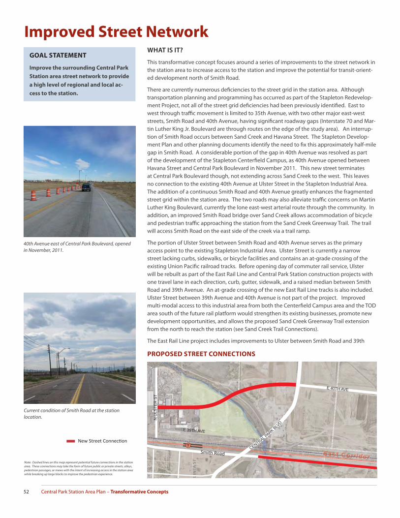
Central Park Station Area Plan – Transformative Concepts52
GOAL STATEMENT
Improve the surrounding Central Park
Station area street network to provide
a high level of regional and local ac-
cess to the station.
WHAT IS IT?
This transformative concept focuses around a series of improvements to the street network in the station area to increase access to the station and improve the potential for transit-orient-ed development north of Smith Road.
There are currently numerous defi ciencies to the street grid in the station area. Although transportation planning and programming has occurred as part of the Stapleton Redevelop-ment Project, not all of the street grid defi ciencies had been previously identifi ed. East to west through traffi c movement is limited to 35th Avenue, with two other major east-west streets, Smith Road and 40th Avenue, having signifi cant roadway gaps (Interstate 70 and Mar-tin Luther King Jr. Boulevard are through routes on the edge of the study area). An interrup-tion of Smith Road occurs between Sand Creek and Havana Street. The Stapleton Develop-ment Plan and other planning documents identify the need to fi x this approximately half-mile gap in Smith Road. A considerable portion of the gap in 40th Avenue was resolved as part of the development of the Stapleton Centerfi eld Campus, as 40th Avenue opened between Havana Street and Central Park Boulevard in November 2011. This new street terminates at Central Park Boulevard though, not extending across Sand Creek to the west. This leaves no connection to the existing 40th Avenue at Ulster Street in the Stapleton Industrial Area. The addition of a continuous Smith Road and 40th Avenue greatly enhances the fragmented street grid within the station area. The two roads may also alleviate traffi c concerns on Martin Luther King Boulevard, currently the lone east-west arterial route through the community. In addition, an improved Smith Road bridge over Sand Creek allows accommodation of bicycle and pedestrian traffi c approaching the station from the Sand Creek Greenway Trail. The trail will access Smith Road on the east side of the creek via a trail ramp.
The portion of Ulster Street between Smith Road and 40th Avenue serves as the primary access point to the existing Stapleton Industrial Area. Ulster Street is currently a narrow street lacking curbs, sidewalks, or bicycle facilities and contains an at-grade crossing of the existing Union Pacifi c railroad tracks. Before opening day of commuter rail service, Ulster will be rebuilt as part of the East Rail Line and Central Park Station construction projects with one travel lane in each direction, curb, gutter, sidewalk, and a raised median between Smith Road and 39th Avenue. An at-grade crossing of the new East Rail Line tracks is also included. Ulster Street between 39th Avenue and 40th Avenue is not part of the project. Improved multi-modal access to this industrial area from both the Centerfi eld Campus area and the TOD area south of the future rail platform would strengthen its existing businesses, promote new development opportunities, and allows the proposed Sand Creek Greenway Trail extension from the north to reach the station (see Sand Creek Trail Connections).
The East Rail Line project includes improvements to Ulster between Smith Road and 39th
Improved Street Network
40th Avenue east of Central Park Boulevard, opened in November, 2011.
Current condition of Smith Road at the station location.
New Street Connecti on
PROPOSED STREET CONNECTIONS
Note: Dashed lines on this map represent potential future connections in the station area. These connections may take the form of future public or private streets, alleys, pedestrian passages, or mews with the intent of increasing access in the station area while breaking up large blocks to improve the pedestrian experience.
UIN
TA
ST
UIN
UIN
UIN
UIN
UIN
UIN
UIN
UINNIN
UUUT
AT
A
TA
T
A
AT
ATTT
ST
ST
STTT
ST
ST
SUUUUU
E 39TH AVE
E 40TH AVE
E 40TH AVE
CENTRAL PARK BLV
D
N U
LSTE
R S
T
Smith Road
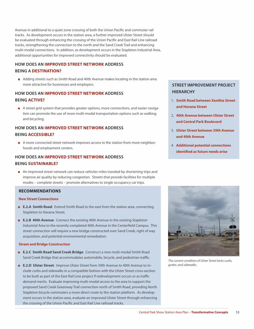
Central Park Show Station Area Plan – Transformative Concepts 53
Avenue in additional to a quiet zone crossing of both the Union Pacifi c and commuter rail tracks. As development occurs in the station area, a further improved Ulster Street should be evaluated through enhancing the crossing of the Union Pacifi c and East Rail Line railroad tracks, strengthening the connection to the north and the Sand Creek Trail and enhancing multi-modal connections. In addition, as development occurs in the Stapleton Industrial Area, additional opportunities for improved connectivity should be evaluated.
HOW DOES AN IMPROVED STREET NETWORK ADDRESS
BEING A DESTINATION?
■ Adding streets such as Smith Road and 40th Avenue makes locating in the station area more attractive for businesses and employers.
HOW DOES AN IMPROVED STREET NETWORK ADDRESS
BEING ACTIVE?
■ A street grid system that provides greater options, more connections, and easier naviga-tion can promote the use of more multi-modal transportation options such as walking and bicycling.
HOW DOES AN IMPROVED STREET NETWORK ADDRESS
BEING ACCESSIBLE?
■ A more connected street network improves access to the station from more neighbor-hoods and employment centers.
HOW DOES AN IMPROVED STREET NETWORK ADDRESS
BEING SUSTAINABLE?
■ An improved street network can reduce vehicles miles traveled by shortening trips and improve air quality by reducing congestion. Streets that provide facilities for multiple modes – complete streets – promote alternatives to single occupancy car trips.
The current condition of Ulster Street lacks curbs, gutter, and sidewalks.
STREET IMPROVEMENT PROJECT
HIERARCHY
1. Smith Road between Xanthia Street
and Havana Street
2. 40th Avenue between Ulster Street
and Central Park Boulevard
3. Ulster Street between 39th Avenue
and 40th Avenue
4. Additional potential connections
identifi ed as future needs arise
RECOMMENDATIONS
New Street Connections
■ E.2.A Smith Road: Extend Smith Road to the east from the station area, connecting Stapleton to Havana Street.
■ E.2.B 40th Avenue: Connect the existing 40th Avenue in the existing Stapleton Industrial Area to the recently completed 40th Avenue in the Centerfi eld Campus. This street connection will require a new bridge constructed over Sand Creek, right of way acquisition, and potential environmental remediation.
Street and Bridge Construction
■ E.2.C Smith Road Sand Creek Bridge: Construct a new multi-modal Smith Road Sand Creek Bridge that accommodates automobile, bicycle, and pedestrian traffi c.
■ E.2.D Ulster Street: Improve Ulster Street from 39th Avenue to 40th Avenue to in-clude curbs and sidewalks in a compatible fashion with the Ulster Street cross-section to be built as part of the East Rail Line project if redevelopment occurs or as traffi c demand merits. Evaluate improving multi-modal access to the area to support the proposed Sand Creek Greenway Trail connection north of Smith Road, providing North Stapleton bicycle commuters a more direct route to the station platform. As develop-ment occurs in the station area, evaluate an improved Ulster Street through enhancing the crossing of the Union Pacifi c and East Rail Line railroad tracks.

Central Park Station Area Plan – Transformative Concepts54
Bridge connection
Future 40th Avenue
Sand Creek TrailImproved Trail Access
Proposed Trail enhancementsto improve station access*
Sand Creek Greenway Trail Connections
GOAL STATEMENT
Increase multi-modal connections to
the station through strategic improve-
ments to the existing trail system.
WHAT IS IT?
The Sand Creek Regional Greenway is an important component of the Denver regional trail system. This 14-mile public greenway connects the High Line Canal in Aurora with the South Platte River Greenway in Commerce City. The trail system then connects to Downtown Denver and the rest of the regional trail system. Strong, direct connections to the Central Park Station are critical for encouraging commuters to utilize the trail and produce additional transit ridership along the East Corridor. On opening day of rail service at Central Park Station the best connection will be from an access ramp from the trail to Smith Road, east of Sand Creek. It will be important that the future design of Smith Road allows for safe pedestrian and bicycle access to the station. An additional connection to consider is a bicycle and pedestrian bridge crossing Sand Creek approximately one-quarter mile north of the station platform. This bridge should be timed as development begins to occur north of the UPRR right of way on both sides of Sand Creek. As improvements occur west of Sand Creek in the existing in-dustrial area, bike facilities should be evaluated for Ulster Street from the creek to Smith Road. Bicyclists will utilize the Ulster Street at-grade railroad crossing to reach Smith Road and fi nally the commuter rail platform. If bicycle commuting increases in the station area, consider a direct connection to the rail platform from the new pedestrian and bicycle bridge over Sand Creek via a path or street along the western boundary of the Sand Creek Prairie Dog Preserve. As infi ll redevelopment occurs in the Stapleton Industrial Area, work with developers to deter-mine the feasibility and implementation of additional multi-modal connections to the station that would benefi t trail users.
A bicyclist turning onto the existing Smith Road Sand Creek bridge to access the Sand Creek Regional Greenway Trail.
Providing improved bicycle connections to the station can promote commuters to choose an alternative to driving a car to the station.
CENTRAL PARK BLVD
E 40TH AVEE 40TH AVE
CENTRAL PARK BLVD
*Note: Dashed lines on this map represent potential future connections in the station area. These connections may take the form of future public or private streets, alleys, pedestrian passages, or mews with the intent of increasing access in the station area while breaking up large blocks to improve the pedestrian experience.
SAND CREEK TRAIL CONNECTIONS TO CENTRAL PARK STATION
UIN
TA
ST
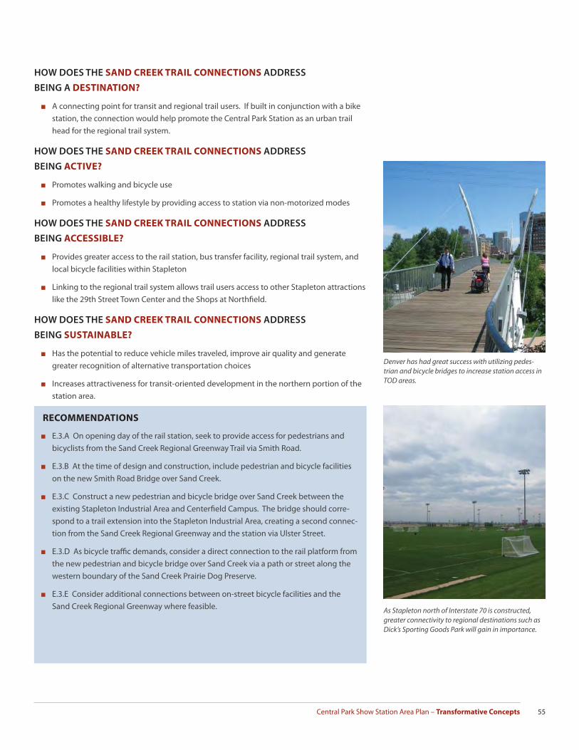
Central Park Show Station Area Plan – Transformative Concepts 55
HOW DOES THE SAND CREEK TRAIL CONNECTIONS ADDRESS
BEING A DESTINATION?
■ A connecting point for transit and regional trail users. If built in conjunction with a bike station, the connection would help promote the Central Park Station as an urban trail head for the regional trail system.
HOW DOES THE SAND CREEK TRAIL CONNECTIONS ADDRESS
BEING ACTIVE?
■ Promotes walking and bicycle use
■ Promotes a healthy lifestyle by providing access to station via non-motorized modes
HOW DOES THE SAND CREEK TRAIL CONNECTIONS ADDRESS
BEING ACCESSIBLE?
■ Provides greater access to the rail station, bus transfer facility, regional trail system, and local bicycle facilities within Stapleton
■ Linking to the regional trail system allows trail users access to other Stapleton attractions like the 29th Street Town Center and the Shops at Northfi eld.
HOW DOES THE SAND CREEK TRAIL CONNECTIONS ADDRESS
BEING SUSTAINABLE?
■ Has the potential to reduce vehicle miles traveled, improve air quality and generate greater recognition of alternative transportation choices
■ Increases attractiveness for transit-oriented development in the northern portion of the station area.
Denver has had great success with utilizing pedes-trian and bicycle bridges to increase station access in TOD areas.
RECOMMENDATIONS
■ E.3.A On opening day of the rail station, seek to provide access for pedestrians and bicyclists from the Sand Creek Regional Greenway Trail via Smith Road.
■ E.3.B At the time of design and construction, include pedestrian and bicycle facilities on the new Smith Road Bridge over Sand Creek.
■ E.3.C Construct a new pedestrian and bicycle bridge over Sand Creek between the existing Stapleton Industrial Area and Centerfi eld Campus. The bridge should corre-spond to a trail extension into the Stapleton Industrial Area, creating a second connec-tion from the Sand Creek Regional Greenway and the station via Ulster Street.
■ E.3.D As bicycle traffi c demands, consider a direct connection to the rail platform from the new pedestrian and bicycle bridge over Sand Creek via a path or street along the western boundary of the Sand Creek Prairie Dog Preserve.
■ E.3.E Consider additional connections between on-street bicycle facilities and the Sand Creek Regional Greenway where feasible. As Stapleton north of Interstate 70 is constructed,
greater connectivity to regional destinations such as Dick’s Sporting Goods Park will gain in importance.

Central Park Station Area Plan – Transformative Concepts56
Station Landmark
GOAL STATEMENT
Provide a visual marker near the sta-
tion that allows easy recognition for
transit users approaching the station
from any direction while enhancing
the public realm and identity of the
area.
WHAT IS IT?
The 2009 Conceptual Station Plan identifi ed the need to locate a vertical landmark or public art piece to give the station an identity, provide a unique character to the area, and serve as a visual marker to commuters arriving at the station from all mode types. The design of the Central Park Station will accommodate the addition of a vertical installation near the inter-section of Smith Road and Uinta Street, either on the western edge of the rail platform or in a public plaza near the bus transfer facility. This location provides excellent sight lines for approaching commuters arriving from Smith Road, Central Park Boulevard, or Uinta Street. As the opening day of service nears, it will be critical to foster partnerships to facilitate the instal-lation of the landmark. The City and County of Denver Department of Arts and Venues, the Stapleton Art Foundation, private donors, and others are likely participants in any partnership. The exact design, scale, and placement of the landmark will need careful consideration to meet the goals and expectations of all stakeholders. The Stapleton air control tower, located directly south of the station near 35th Avenue, is a clear opportunity to relate the landmark to the long aviation history of the Stapleton neighborhood.
HOW DOES THE STATION LANDMARK ADDRESS BEING A DESTINATION?
■ Adds to the unique character and gives an identity to the area.
HOW DOES THE STATION LANDMARK ADDRESS BEING ACTIVE?
■ Promotes greater pedestrian and bicyclist activity by providing a visual marker for ap-proaching commuters
Several pieces of large-scale artwork are located in the Pena Boulevard corridor as travelers approach or depart the Denver International Airport. The East Rail Line continues past Stapleton and is aligned parallel to Pena Boulevard as it nears DIA.
Union Station’s sign and slogan, “Travel by Train” is almost as iconic as the building itself and helps give an identity to it’s neighborhood.
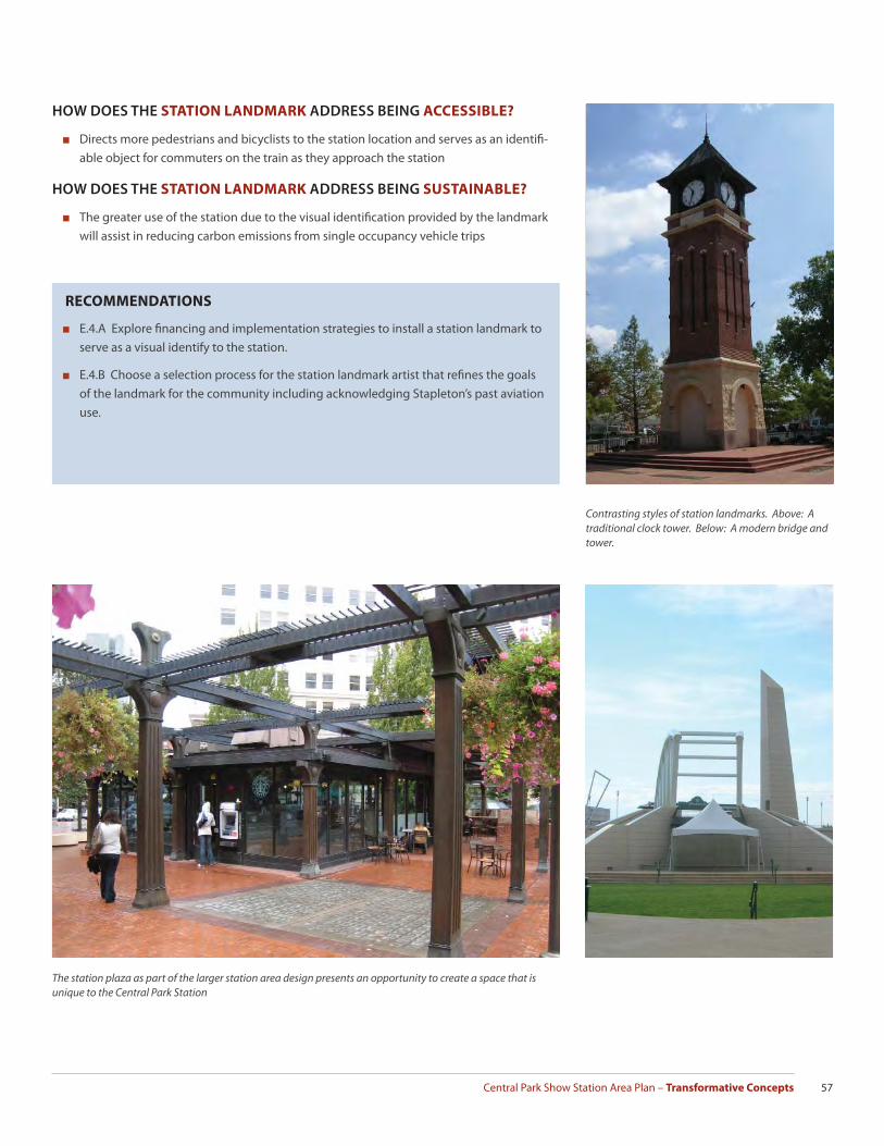
Central Park Show Station Area Plan – Transformative Concepts 57
HOW DOES THE STATION LANDMARK ADDRESS BEING ACCESSIBLE?
■ Directs more pedestrians and bicyclists to the station location and serves as an identifi -able object for commuters on the train as they approach the station
HOW DOES THE STATION LANDMARK ADDRESS BEING SUSTAINABLE?
■ The greater use of the station due to the visual identifi cation provided by the landmark will assist in reducing carbon emissions from single occupancy vehicle trips
RECOMMENDATIONS
■ E.4.A Explore fi nancing and implementation strategies to install a station landmark to serve as a visual identify to the station.
■ E.4.B Choose a selection process for the station landmark artist that refi nes the goals of the landmark for the community including acknowledging Stapleton’s past aviation use.
Contrasting styles of station landmarks. Above: A traditional clock tower. Below: A modern bridge and tower.
The station plaza as part of the larger station area design presents an opportunity to create a space that is unique to the Central Park Station

Central Park Station Area Plan – Transformative Concepts58
Mockingbird Station in Dallas, Texas is a well known example of transit oriented development closely weaved into a passenger rail station.
This station in Portland, Oregon directly addresses the rail platform, increasing the ease of access for it’s residents.
GOAL STATEMENT
Achieve a sustainable, innovative sta-
tion design that promotes a walkable,
mixed-use, transit-oriented com-
munity for Stapleton and adjacent
neighborhoods.
Innovative Station Site DesignWHAT IS IT?
Early in the planning process, stakeholders stated their desire that development happen near the station “sooner than later”. Even though this may be a common desire for many TOD locations, Central Park Station does have several factors that give it a unique advantage to promote transit-oriented development. These advantages include having a master developer over a signifi cant portion of the station area, large amounts of undeveloped land, a popular, successful adjacent residential neighborhood, interstate highway access, and high visibility contribute to the overall appeal of the station.
Development Scenarios
On opening day of commuter rail service, Central Park Station will serve primarily as a Park-n-Ride lot. RTD has 70 such Park-n-Ride lots serving both light rail and bus service across the Denver region. On the East Rail Line, each station will have surface parking lots for commut-ers except the end-of-line stations at Denver International Airport and Denver Union Station. Because the demand for parking may continue well into the future at these stations, parking structures constructed to allow the repurposing of the initial surface parking lots into a higher and better use will be necessary. The 2009 conceptual station plan envisioned how transit-oriented development could occur at the Central Park Station, including the location of a
2009 Conceptual Plan - Phase Two: Transit Oriented Development replaces RTD’s surface parking lots. RTD and TOD shares structured parking incorporated into the development.
2009 Conceptual Plan - Phase One: RTD’s Bus Transfer Facility and Park -n -Ride

Central Park Show Station Area Plan – Transformative Concepts 59
1,500 parking structure on the same block as the bus transfer facility. RTD has further concep-tualized the bus transfer facility with a north to south orientation with access from Smith Road and 37th Avenue.
Additional development scenarios and concepts may further this vision of a transit-oriented future for the Central Park Station and possibly remove barriers to accelerate development. Three additional development scenarios to consider include:
Alternate Location for a Public/Private Partnership Parking Garage
The 2009 Station Conceptual Plan considered the future parking structure adjacent to the bus transfer facility. The construction of this parking structure is contingent on RTD identify-ing a private partner to share in the costs of the garage. Alternate locations for the parking structure may need consideration to facilitate this necessary public/private partnership. The RTD property at Central Park Station provides multiple options for private development that integrates a parking structure and promoting this added fl exibility to the fi nal build out of the station may encourage development to occur at a quicker rate.
Small Swap
This development scenario considers a small land swap between RTD and Forest City near the bus transfer facility. In an eff ort to utilize the most valuable land for development sooner, For-est City obtains from RTD the property north of 37th Avenue and directly east of Uinta Street in exchange for a parcel south of 37th Avenue and directly west of Central Park Boulevard. This allows Forest City to develop one of the most desirable locations within the station area as soon as the market bears and establishes a strong street wall near the station along Uinta Street, which is the primary pedestrian corridor for the station. The small swap could occur before or after the opening day of rail service.
Large Swap
This development scenario expands on the small land swap to include all of the RTD Park-n-Ride facility west of Uinta Street. The station site plan for opening day utilizes the land closest to the station along Smith Road for commuter parking. The large land swap concept proposes a move of the RTD Park-n-Ride in part or in total to the east of Uinta Street, from Smith Road to 36th Avenue. Forest City obtains the two large development parcels north of the future 37th Avenue in exchange for this property with the ability to market the parcels as the most desirable development opportunity near the station with high visibility due to the frontage along Smith Road. This scenario could occur before or after the opening day of rail service. If it occurs after opening day, the large swap will likely tie into a public/private partnership to construct a parking structure as a second phase of the station’s development and may not include an actual land exchange between RTD and Forest City.
A Green Station
The Stapleton Redevelopment Plan sets goals and objectives to restore and protect the area’s environmental resources while demonstrating innovative approaches to development that emphasize effi ciency and reduced resource consumption. The RTD Park-n-Ride and bus transfer facility is a great opportunity to employ sustainability measures in its design and construction. On-site power generation through solar roofs or wind turbines would reduce energy consumption at the station. Utilizing stormwater best management practices such as bioswales, porous pavers, and other green technologies in the parking lots further the sustainability of the station. Since the long-term vision for the station focuses on a walkable, mixed-use urban environment, consideration on how green construction methods could minimize initial capital costs for the station while reducing long-term maintenance and future redevelopment costs is needed.
E
PCC
XC EL
RTDCO MM
HO USETC
HO USE
Possible land swaps have been explored by RTD and Forest City. Above: A small swap scenario that brings development to Uinta Street in place of surface parking. Below: A big swap scenario where parking is relocated further from the rail platform.
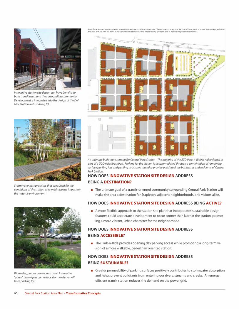
Central Park Station Area Plan – Transformative Concepts60
HOW DOES INNOVATIVE STATION SITE DESIGN ADDRESS
BEING A DESTINATION?
■ The ultimate goal of a transit-oriented community surrounding Central Park Station will make the area a destination for Stapleton, adjacent neighborhoods, and visitors alike.
HOW DOES INNOVATIVE STATION SITE DESIGN ADDRESS BEING ACTIVE?
■ A more fl exible approach to the station site plan that incorporates sustainable design features could accelerate development to occur sooner than later at the station, promot-ing a more vibrant, urban character for the neighborhood.
HOW DOES INNOVATIVE STATION SITE DESIGN ADDRESS
BEING ACCESSIBLE?
■ The Park-n-Ride provides opening day parking access while promoting a long-term vi-sion of a more walkable, pedestrian oriented station.
HOW DOES INNOVATIVE STATION SITE DESIGN ADDRESS
BEING SUSTAINABLE?
■ Greater permeability of parking surfaces positively contributes to stormwater absorption and helps prevent pollutants from entering our rivers, streams and creeks. An energy effi cient transit station reduces the demand on the power grid.
Stormwater best practices that are suited for the conditions of the station area minimize the impact on the natural environment.
Bioswales, porous pavers, and other innovative “green” techniques can reduce stormwater runoff from parking lots.
An ultimate build-out scenario for Central Park Station - The majority of the RTD Park-n-Ride is redeveloped as part of a TOD neighborhood. Parking for the station is accommodated through a combination of remaining surface parking lots and parking structures that also provide parking of the businesses and residents of Central Park Station.
Innovative station site design can have benefi ts to both transit users and the surrounding community. Development is integrated into the design of the Del Mar Station in Pasadena, CA.
Note: Some lines on this map represent potential future connections in the station area. These connections may take the form of future public or private streets, alleys, pedestrian passages, or mews with the intent of increasing access in the station area while breaking up large blocks to improve the pedestrian experience.

Central Park Show Station Area Plan – Transformative Concepts 61
RECOMMENDATIONS
■ E.5.A Seek station site design that allows the greatest opportunity for future transit ori-ented development to occur as quickly as possible. Station site design should consider future development through:
▪ Sizing of parking lots to accommodate future building footprints
▪ Future street connectivity
▪ Pedestrian access
▪ Multiple options for future structured parking
■ E.5.B Utilize sustainable stormwater best practices when designing the station area. Specifi c opportunities include:
▪ Bioswales
▪ Rain gardens
▪ Reduced interior curbs
▪ Porous pavers
■ E.5.C Prioritize the reduction of impervious surfaces.
■ E.5.D Pursue transit-oriented residential and commercial development at the station as market conditions deem feasible.
Sustainable design that is sensitive to the existing natural environment is a important principle of the Stapleton Development Plan.
Mid-block connections in the future transit oriented development anticipated to replace the initial surface parking lots could be utilized to break up large blocks near the station.

Central Park Station Area Plan – Transformative Concepts62
GOAL STATEMENT
Long-term redevelopment of Quebec
Square into a more walkable, mixed-
use shopping and residential neigh-
borhood
WHAT IS IT?
Quebec Square was one of the fi rst developments built in Stapleton, with stores opening in 2002 and 2003. The Power Retail center has 740,000 square feet of retail space, with Wal-Mart, Sam’s Club, and Home Depot as the major anchors. The site plan for Quebec Square acknowl-edges the existing Denver street grid with several city streets providing access and circulation for the shopping center. 35th and 36th Avenues are major east/west streets providing access to Quebec Square from Stapleton and adjacent neighborhoods. Syracuse Street, Roslyn Street, and 38th Avenue are private streets that provide internal circulation within Quebec Square. The pad sites located along 36th, 38th, Syracuse, and Roslyn streets have buildings that are either partially or completely oriented towards the street, which begins to create a more pedestrian friendly area. It is reasonable to expect that as Quebec Square ages, incre-mental or comprehensive alterations will substantially change its function, form and appear-ance. As development occurs near the Central Park Station, pressure to increase the inten-sity of uses within the shopping center may occur. In this situation, the parking lots would become candidates for retrofi tting to accommodate mixed-use residential development. If an incremental redevelopment approach is taken, a phased strategy to manage the transition from an auto-oriented retail center to a mixed-use development will need to be considered. Establishing further connections to the existing street grid, including the addition of new public streets within Quebec Square, improves connectivity to expected high-density resi-dential development near the station. The continuation of the existing street block pattern is essential to the transition of Quebec Square into a more urban, mixed-use shopping and residential neighborhood within the greater Stapleton redevelopment.
Quebec Square Redevelopment
Quebec Square draws shoppers from all over Northeast Denver and surrounding communities.
Some of the private streets within Quebec Square function very much like public streets including providing on-street parking.
The Park Hill neighborhood (green) west of Quebec Street utilizes the traditional Denver street grid. Central Park Station (yellow) will be built with a similar grid. In order for Quebec Square to knit these areas together, a stronger block structure needs to be established.
E SMITH RD
E 35TH AVE
N O
LIVE
ST
N P
ON
TIA
C S
T
T
E 33RD AVE
E 39TH AVE
N N
EWPO
RT
ST
E SANDOWN RDE 40TH AVE
E 32ND AVEE MARTIN LUTHER KING BLVD
N S
YRA
CU
SE S
T
N P
OPL
AR
ST
E 38TH AVE
N R
OSL
YN S
T
AY
N S
YRA
CU
SE S
T
E 38TH AVE
N O
LIVE
ST
E 40TH AVE
N P
OPL
AR
ST
N O
NEI
DA
ST
N O
NEI
DA
ST
N P
ON
TIA
C S
T
N Q
UEB
EC S
T
RO
SLYN
ST
E 36TH AVE
UIN
TA S
T
ULS
TER
ST
POTENTIAL FUTURE STREET
AVEAVE35THH35TH
NO
NEI
DA
STN
ON
EID
AST
E 3E 3
NPO
NTI
AC
ST
NPO
PLA
RST
NPO
PLA
RST
E 33RR
NO
LIVE
ST
BLLVVLLLL DD
D AVED
Note: Dashed lines on this map represent potential future connections in the station area. These connections may take the form of future public or private streets, alleys, pedestrian passages, or mews with the intent of increasing access in the station area while breaking up large blocks to improve the pedestrian experience.
STREET GRID AND BLOCK PATTERN CONTEXT
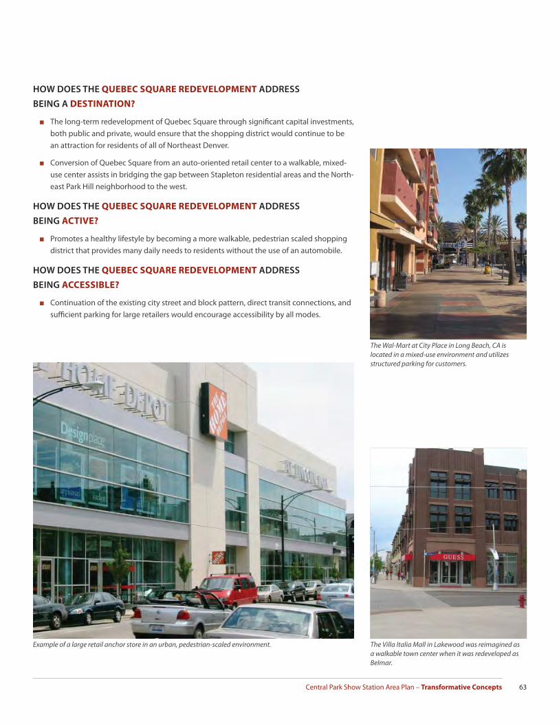
Central Park Show Station Area Plan – Transformative Concepts 63
The Wal-Mart at City Place in Long Beach, CA is located in a mixed-use environment and utilizes structured parking for customers.
The Villa Italia Mall in Lakewood was reimagined as a walkable town center when it was redeveloped as Belmar.
HOW DOES THE QUEBEC SQUARE REDEVELOPMENT ADDRESS
BEING A DESTINATION?
■ The long-term redevelopment of Quebec Square through signifi cant capital investments, both public and private, would ensure that the shopping district would continue to be an attraction for residents of all of Northeast Denver.
■ Conversion of Quebec Square from an auto-oriented retail center to a walkable, mixed-use center assists in bridging the gap between Stapleton residential areas and the North-east Park Hill neighborhood to the west.
HOW DOES THE QUEBEC SQUARE REDEVELOPMENT ADDRESS
BEING ACTIVE?
■ Promotes a healthy lifestyle by becoming a more walkable, pedestrian scaled shopping district that provides many daily needs to residents without the use of an automobile.
HOW DOES THE QUEBEC SQUARE REDEVELOPMENT ADDRESS
BEING ACCESSIBLE?
■ Continuation of the existing city street and block pattern, direct transit connections, and suffi cient parking for large retailers would encourage accessibility by all modes.
Example of a large retail anchor store in an urban, pedestrian-scaled environment.
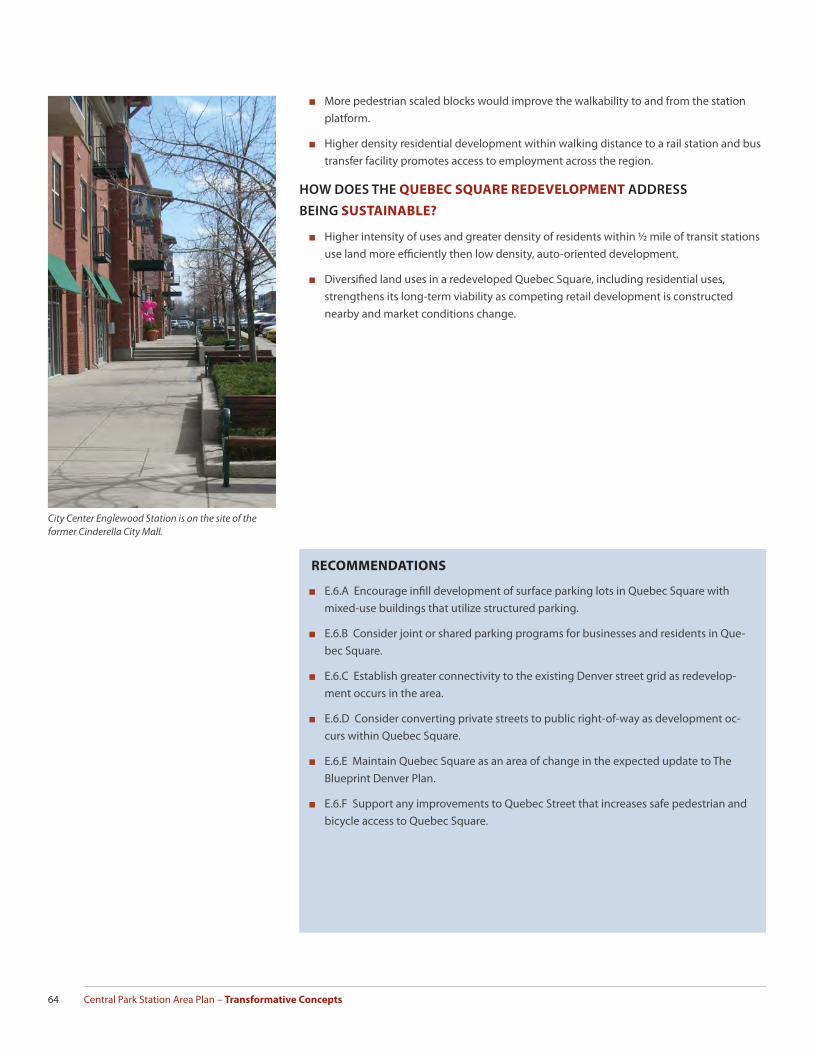
Central Park Station Area Plan – Transformative Concepts64
RECOMMENDATIONS
■ E.6.A Encourage infi ll development of surface parking lots in Quebec Square with mixed-use buildings that utilize structured parking.
■ E.6.B Consider joint or shared parking programs for businesses and residents in Que-bec Square.
■ E.6.C Establish greater connectivity to the existing Denver street grid as redevelop-ment occurs in the area.
■ E.6.D Consider converting private streets to public right-of-way as development oc-curs within Quebec Square.
■ E.6.E Maintain Quebec Square as an area of change in the expected update to The Blueprint Denver Plan.
■ E.6.F Support any improvements to Quebec Street that increases safe pedestrian and bicycle access to Quebec Square.
City Center Englewood Station is on the site of the former Cinderella City Mall.
■ More pedestrian scaled blocks would improve the walkability to and from the station platform.
■ Higher density residential development within walking distance to a rail station and bus transfer facility promotes access to employment across the region.
HOW DOES THE QUEBEC SQUARE REDEVELOPMENT ADDRESS
BEING SUSTAINABLE?
■ Higher intensity of uses and greater density of residents within ½ mile of transit stations use land more effi ciently then low density, auto-oriented development.
■ Diversifi ed land uses in a redeveloped Quebec Square, including residential uses, strengthens its long-term viability as competing retail development is constructed nearby and market conditions change.

Central Park Show Station Area Plan – Transformative Concepts 65
A combination of mixed-use buildings and parking structures as infi ll development in the existing surface park-ing lots would dramatically increase the density in Quebec Square while improving the pedestrian experience.
P
P
P
P
P
Note: Dashed lines on this map represent potential future connections in the station area. These connections may take the form of future public or private streets, alleys, pedestrian passages, or mews with the intent of increasing access in the station area while breaking up large blocks to improve the pedestrian experience.
STREET GRID AND BLOCK PATTERN CONTEXT – EXISTING
STREET GRID AND BLOCK PATTERN CONTEXT – POTENTIAL
P
Existing Private Street
Potential Future Connection
Existing Public Street
Existing Private Street
Existing Public Street
Potential Future Parking Structure
Potential Future Mixed-Use Development
SMITH ROAD
35TH AVE
36TH AVE
38TH AVE
SYRA
CUSE
ST
ULS
TER
ST
ROSL
YN S
TSMITH ROAD
38TH AVE
SYRA
CUSE
ST
ULS
TER
ST
ROSL
YN S
T
35TH AVE
36TH AVE

Central Park Station Area Plan – Transformative Concepts66
Intermodal Transportation Center (ITC)
WHAT IS IT?
An intermodal transportation center (ITC) that centralizes and coordinates multiple mobility options would provide great benefi t to Stapleton and the surrounding areas. The ITC could function either as a stand-alone concept or in conjunction with a future parking structure. The Central Park Station will have rail service every 15 minutes from both Denver Union Sta-tion and Denver International Airport for the majority of the day. A 12-bay bus facility, serving ten or more routes, provides additional connections to destinations in east Denver, Aurora, and other parts of the RTD service area. An ITC that included bike rentals, car sharing, and taxi service has great potential to make the station a transit rich location. Major elements in a Central Park Station Intermodal Transportation Center may include:
■ Bike sharing and bike rental program: These bike programs turn the station into an “urban trail head”, providing access to the wide array of parks and open space in Stapleton and the Sand Creek Greenway. Bike sharing, as illustrated by the success of the Denver B-Cycle program, can help complete the “last mile” of a trip, making nearby des-tinations, such as the 29th Street Town Center, more accessible for transit users. A bike rental service provides options for bicyclists that enjoy longer rides and may be seeking major destinations on the regional trail network such as Bluff Lake, the Rocky Mountain Arsenal, or Dick’s Sporting Goods Park. More details about these potential programs are located in the Bike Sharing Transformative Concept.
■ Bike Station: The station should include the availability of repair and maintenance services, secured interior bike storage, product sales, and shower facilities.
■ Car-sharing Program: The eGo CarShare service found in the 29th Street Town Center is a model for similar service at the Central Park Station. This feature adds mobility options for travelers needing to reach destinations beyond walking or bicycling distance from
GOAL STATEMENT
Create a centralized location for users
to access a wide variety of multi-mod-
al transportation options.
A bike sharing program would extend the commuter shed to the station.
Bike Stations provide secure storage for bikes as well as maintenance, product sales and shower facilities.Bike stations often include maintenance and repair.
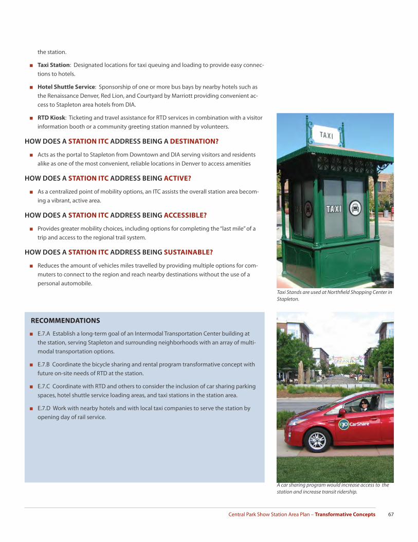
Central Park Show Station Area Plan – Transformative Concepts 67
the station.
■ Taxi Station: Designated locations for taxi queuing and loading to provide easy connec-tions to hotels.
■ Hotel Shuttle Service: Sponsorship of one or more bus bays by nearby hotels such as the Renaissance Denver, Red Lion, and Courtyard by Marriott providing convenient ac-cess to Stapleton area hotels from DIA.
■ RTD Kiosk: Ticketing and travel assistance for RTD services in combination with a visitor information booth or a community greeting station manned by volunteers.
HOW DOES A STATION ITC ADDRESS BEING A DESTINATION?
■ Acts as the portal to Stapleton from Downtown and DIA serving visitors and residents alike as one of the most convenient, reliable locations in Denver to access amenities
HOW DOES A STATION ITC ADDRESS BEING ACTIVE?
■ As a centralized point of mobility options, an ITC assists the overall station area becom-ing a vibrant, active area.
HOW DOES A STATION ITC ADDRESS BEING ACCESSIBLE?
■ Provides greater mobility choices, including options for completing the “last mile” of a trip and access to the regional trail system.
HOW DOES A STATION ITC ADDRESS BEING SUSTAINABLE?
■ Reduces the amount of vehicles miles travelled by providing multiple options for com-muters to connect to the region and reach nearby destinations without the use of a personal automobile.
RECOMMENDATIONS
■ E.7.A Establish a long-term goal of an Intermodal Transportation Center building at the station, serving Stapleton and surrounding neighborhoods with an array of multi-modal transportation options.
■ E.7.B Coordinate the bicycle sharing and rental program transformative concept with future on-site needs of RTD at the station.
■ E.7.C Coordinate with RTD and others to consider the inclusion of car sharing parking spaces, hotel shuttle service loading areas, and taxi stations in the station area.
■ E.7.D Work with nearby hotels and with local taxi companies to serve the station by opening day of rail service.
Taxi Stands are used at Northfi eld Shopping Center in Stapleton.
A car sharing program would increase access to the station and increase transit ridership.

Central Park Station Area Plan – Transformative Concepts68
WHAT IS IT?
Bike sharing and bike rental programs have seen recent success at both the local and national level. The local B-Cycle bike-sharing program provides daily, weekly, and annual members ac-cess to over 500 bikes and 51 stations in Downtown Denver and nearby neighborhoods. The program makes it convenient and economical to substitute bicycle trips for automobile trips to nearby destinations such as a local park, grocery store, or restaurant. A bike-sharing pro-gram is a viable “last-mile” option for commuters and visitors on opening day of Central Park Station and only increases in value once higher density development occurs near the station.
Bike rental programs are a common amenity in tourist locations and are currently available at three popular Denver city parks (City, Washington, and Berkeley). At Central Park Station, such a program may coordinate with a bike station that provides long-term rental, maintenance, secured storage, and other services. These longer, daily rental bikes serve users interested in accessing the Sand Creek Regional Greenway Trail that connects to the regional trail system and destinations such as Bluff Lake, the Rocky Mountain Arsenal, or Dick’s Sporting Goods Park. The bike rental users also have access to any of the trails within Stapleton’s parks and greenways.
Bike Sharing and Rental Programs
GOAL STATEMENT
Create a bike sharing and rental pro-
gram in the station area that provides
alternatives to single occupancy au-
tomobile trips for both local residents
and visitors.
Downtown Denver and nearby neighborhoods are currently served by the Denver B-Cycle Program
Existing Stapleton neighborhoods have strong bicycle infrastructure.
The Denver B-Cycle Program is a local example of a bike sharing program.

Central Park Show Station Area Plan – Transformative Concepts 69
HOW DO BIKE SHARING AND RENTAL PROGRAMS ADDRESS
BEING A DESTINATION?
■ Acts as the portal to Stapleton from Downtown and DIA serving visitors and residents alike as one of the most convenient, reliable locations in Denver to access amenities
HOW DO BIKE SHARING AND RENTAL PROGRAMS ADDRESS
BEING ACTIVE?
■ As a centralized point of mobility options, an ITC assists the overall station area becom-ing a vibrant, active area.
HOW DO BIKE SHARING AND RENTAL PROGRAMS ADDRESS
BEING ACCESSIBLE?
■ Provides greater mobility choices, including options for completing the “last mile” of a trip and access to the regional trail system.
HOW DO BIKE SHARING AND RENTAL PROGRAMS ADDRESS
BEING SUSTAINABLE?
■ Reduces the amount of vehicles miles travelled by providing multiple options for com-muters to connect to the region and reach nearby destinations without the use of a personal automobile.
RECOMMENDATIONS
■ E.8 Develop a bike sharing and rental program and analyze fi nancing strategies with interested stakeholders such as the Stapleton Transportation Management Area, the Sand Creek Regional Greenway, RTD, Forest City, Quebec Square, and Shops at Northfi eld. An existing or new non-profi t organization may be required to develop the program.
Bicycle rental programs exist at several Denver city parks.
A bike rental program would enhance the Sand Creek Regional Greenway’s opportunity to provide residents with access to the natural environment.


Central Park Show Station Area Plan – Moving Forward 71
M o v i n g F o r w a r d
Implementation of a plan for the Central Park Station Area is accomplished incrementally over many years through the eff orts of the City government, residents, business owners, property owners, and nonprofi t organizations. The plan provides a picture into the future of what the community wants the station area to become. As a result, the image of “what we want” is clear. The “how we are going to get there” will be the responsibility of the numerous studies and project planning that will be developed to forward specifi c objectives and projects within the context of city-wide priorities and resource availability.

Central Park Station Area Plan – Moving Forward72
PLAN IMPLEMENTATION
The implementation matrix that concludes this chapter summarizes the recommended strategies, associated with the Strategy Framework and Transformative Concepts. Each one is further defi ned by type, timeframe, funding source, and lead entity.
IMPLEMENTATION TYPES
Blueprint Denver identifi es three types of implementation activities: regulatory or policy, public investment, and partnership. The Central Park Station Area Plan also recognizes the importance of private development and business investment in realizing the plan.
■ Regulatory and policy strategies change City codes or regulations to aff ect desired out-comes. Typical examples include Denver Zoning Code text and map amendments, Pub-lic Works requirements for infrastructure improvements associated with development projects, and Parks and Recreation requirements regarding open space and plantings.
■ Public investment strategies are those involving public funding of public infrastructure. Examples include street reconstruction, bike lanes, new transit lines, park improvements, or new or expanded recreation centers. The City takes the lead in designing, construct-ing, and funding these projects and may use a variety of public funding sources such as the annual Capital Improvements Program, bond funds, or state or federal grant programs.
■ Partnership strategies represent the most diverse category. Public-private partnership (PPP) activity has expanded exponentially and has gone well beyond public subsidy of a private development project. Increasingly public-private partnerships are being used to fund public infrastructure projects. Denver Union Station and RTD’s East and Gold Lines are among the largest PPP projects in the country.
IMPLEMENTATION TIMEFRAMES
Timeframes recognize both the order in which certain strategies must be undertaken and the feasibility of undertaking them given known resources. As a result, the timeframes provide guidance for expectations and initial eff orts. Every opportunity to advance a plan should be taken, regardless of the suggested timing.
This plan recognizes four time-frames:
■ Short-term one to three years
■ Medium-term four to ten years
■ Long-term beyond ten years
■ On-going continuing application/utilization
FUNDING SOURCES
The Implementation Framework identifi es possible funding sources for public improvements and studies. The Plan is a forward-looking document which contemplates a vision for future development. Funding sources available to public and private entities are continually evolv-ing based on economic, political, legal and neighborhood objectives. Though the names and purposes of funding sources change over time, they fall into three distinct categories.
■ Tax Base Support: Tax base supported sources are characterized by the involvement of the local sales and property taxing authorities. The most common tax base support is through the City’s annual budget, especially the annual Capital Improvements Program (CIP). Periodically, the City requests its voters to approve a tax increase to pay for specifi c
Implementation Framework
Central Park Show Station Area Plan – Moving Forward 73
public improvements. For instance, the citizens of Denver voted in 2007 to raise their property taxes in a specifi c amount to support the issuance of over $500 million Better Denver Bonds whose proceeds funded 290 specifi c public improvements.
Tax Increment Finance is another means of tax-base support most typically associ-ated with an Urban Renewal Area. Once created by the City Council and Denver Urban Renewal Authority (DURA), property and sales tax over and above the base year are paid to DURA to be used to pay for eligible public improvements. Designation as an Urban Renewal Area occurred for Stapleton in 1997.
■ Grants: Grants come from public or private organizations that are interested in en-couraging a specifi c outcome and these grants typically include specifi c conditions and requirements as to how the funds may be deployed. For instance, a state or federal transportation grant will need to be used for street, mass transit, or regional mobil-ity studies or projects. The Offi ce of Economic Development receives federal funds to support certain types of housing projects. Additionally, foundations provide grants for projects orientated with the organization’s goals, such as green spaces or social services.
■ Special Districts: The City Charter and State Statute enable various types of districts to be created. Examples of special districts include Business Improvement Districts, Met-ropolitan Districts, Local Improvement or Maintenance Districts, and General Improve-ment Districts. The districts are classifi ed as special because they are typically created by a localized group of citizens who want to achieve specifi c outcomes in their locality and are willing to pool their economic resources in order to implement identifi ed projects. For example, if a majority of business owners desire to improve the streetscape of the street in which they operate, the businesses could organize a Business Improvement District which would assess the participants an amount of money suffi cient to pay for the project. Special districts are a useful tool when a localized population desire and are willing to pay for an enhanced level of public improvement. District revenues can be used to pay for improvements on a “pay-as-you-go basis”, for ongoing operations and maintenance, or to support payment of bonds.
Two Metropolitan Districts have been established within Stapleton, the Park Creek Met-ropolitan District and the Westerly Creek Metropolitan District, to construct the necessary infrastructure and planned open space system for the neighborhood.
■ Lead Entity: The implementation matrix identifi es a lead entity that the plan recom-mends for having primary responsibility for undertaking the implementation recom-mendation. The entities are recommendations only. Other public and private entities may have roles to initiate, undertake, or participate in these eff orts.
CHAMPIONS AND ADVOCATES
Once a plan is adopted as a supplement to the Comprehensive Plan, the City has direction to implement the plan. Given the number of plans providing this direction, competing interests in the city, and the budget issues at all levels of government, little plan implementation is undertaken without champions for certain actions and advocates for the plan area. Typically registered neighborhood organizations work with the Mayor and their City Council represen-tatives to promote certain actions and outcomes. Membership organizations such as mer-chant associations, business partnerships, and non-profi ts do the same for business areas. The Downtown Denver Partnership’s focus on implementation of the Downtown Area Plan both as part of their organizational work program and their advocacy with the City is one example of a concerted eff ort at implementing a plan.

Central Park Station Area Plan – Moving Forward74
BLUEPRINT DENVER FUTURE LAND USE CONCEPTS
Blueprint Denver, Denver’s integrated land use and transportation plan adopted in 2002, identifi es Areas of Change and Areas of Stability throughout the city with the goal of direct-ing new development and infi ll projects toward Areas of Change. Blueprint Denver estab-lished land use types based on a framework of “building blocks” – Districts, Residential Areas, Centers, and Corridors. Each category has individual land use types and describes a particu-lar character and scale that is desired in the future but does not necessarily refl ect existing conditions. The Central Park Station Plan uses this as the basis of its recommended land use map. Two sub-categories of land uses, Industrial – Mixed Use and TOD Employment, have been added to the Central Park Station Land Use Map found on page 17 to refl ect the specifi c conditions in the plan area. Those land use concepts are shown here as Industrial and Mixed Use respectively to illustrate how those recommendations translate to an updated Blueprint Concept Land Use map. The Blueprint Denver Plan map will be amended as needed based on this plan. The Central Platte Valley, an example of transit
oriented development in Denver.
Station areas on the Southeast Line, such as Arapahoe at Village Center, are employment focused.
Industrial Mixed-Use can support a wide variety of building forms and business types.
BLUEPRINT DENVER CONCEPT LAND USE MAP - EXISTING
N

Central Park Show Station Area Plan – Moving Forward 75
T
BLUEPRINT DENVER CONCEPT LAND USE MAP - PLAN RECOMMENDATION
Note: Dashed lines on this map represent potential future connections in the station area. These connections may take the form of future public or private streets, alleys, pedestrian passages, or mews with the intent of increasing access in the station area while breaking up large blocks to improve the pedestrian experience.

Central Park Station Area Plan – Moving Forward76
BLUEPRINT DENVER STREET CLASSIFICATIONS
The Central Park Station Area Plan plan draws on the street classifi cations and types estab-lished by Blueprint Denver and makes recommendations for updates based on the future land use and mobility vision for the area. The Blueprint Denver Street Classifi cation Map will be amended as needed based on this plan. The future street classifi cation maps on the following pages show this plan’s recommendations for updates.
BLUEPRINT DENVER STREET
CLASSIFICATIONS
■ Functional Street Classifi cations: Blueprint Denver provides functional street classifi cations that are intended to encompass both design character-istics of the streets and the character of service the streets are intended to provide. The functional classifi cation system recognizes that individual streets do not act independently of one another but instead form a network that works together to serve travel needs on a local, citywide, and regional level.
Blueprint Denver recognized and retains the City’s existing classifi cation system of arterials, collectors and local streets, but also presents criteria to better classify the function of the city’s streets. The four functional street cat-egories identifi ed in Blueprint Denver are Arterial Streets, Collector Streets, Local streets, and Downtown Access Streets. The functional classifi cation broadly defi nes its design and opera-tional characteristics as they relate to the movement of motor vehicles.
■ Multi-Modal Street Classifi cations: The Multi-Modal Street Type defi ne streets by relating them to the adja-cent land use and their function for pedestrians, bicyclists, and transit. The street types attempt to strike a bal-ance between functional classifi cation, adjacent land use, and competing travel needs. There are fi ve multi-modal street type categories that include Residential Street, Main Street, Mixed-Use Street, Commercial Street, and industrial street.
EXISTING BLUEPRINT DENVER STREET CLASSIFICATIONS
N

Central Park Show Station Area Plan – Moving Forward 77
FUTURE BLUEPRINT DENVER STREET CLASSIFICATIONS
N
Note: Dashed lines on this map represent potential future connections in the station area. These connections may take the form of future public or private streets, alleys, pedestrian passages, or mews with the intent of increasing access in the station area while breaking up large blocks to improve the pedestrian experience.

Central Park Station Area Plan – Moving Forward78
Regulatory and Policy Tools
RECOMMENDATIONS IMPLEMENTATION STRATEGY TIMEFRAMELEAD
STAKEHOLDERSB.1 - B.4; B.6; C.3.A; D.1.A; E.1.A - E.1.D
Design Review
Conduct a review of existing design standards and guidelines for the station area and make any necessary changes to refl ect plan recommen-dations including Active Edges, Building Frontages, Building Placement and Massing, Pedestrian Priority Streets, Key Intersections, Gateways, and Location of Parks, Plazas, and Open Space.
Short
Department of Plan-ning and Community Development (CPD) and Stapleton Devel-opment Corporation (SDC)
D.3.A - D.3.E
Housing Sustainability
Coordinate the City’s existing aff ordable housing strategies to build multi-family development within the station area that contains 20% or more aff ordable housing units. Short
City and County of Denver, Regional Transportation Dis-trict (RTD)
E.6.D Maintain Quebec Square as an area of change in the expected update to the Blueprint Denver Plan.
Short CPD
C.5; E.1.F; D.2.F; D.2.G
Bus Service
Adopt a service plan that distributes bus routes through the major street network that serves the neighborhood and transit facility while promot-ing access to fresh food, civic uses, and recognizing Uinta Street as the neighborhoods pedestrian priority street.
Short - MediumRTD, Transportation Management Associa-tion (TMA), others
A.1 - A.3; D.4.A; E.6.A,
TOD Zoning
Much of the station already has TOD-friendly zoning that allows for increased densities and reductions in parking, enable mixed-use develop-ment, and prohibit new uses that would not be transit supportive. New zoning is needed as private developers begin to consider redevelopment opportunities in Quebec Square and other possible infi ll locations.
MediumCPD and Private Developers
A.4 Use building form and design standards to ease the transition between the TOD development and surrounding residential neighborhoods. Medium
CPD, Forest City, Pri-vate Developers
A.5 Change existing residential neighborhoods to Areas of Stability Short CPD
B.5 Promote the integration of cultural activity generators as part of larger, mixed-use, higher-density development projects. Medium
CPD, Forest City, Pri-vate Developers
D.4.B; D.4.D Seek and retain employers in the station area with a high jobs-per-acre-ratio including the development of Centerfi eld Campus as a location for large corporate offi ce tenants, research and design facilities, or appropri-ate light industrial uses.
On-going
Forest City, Offi ce of Economic Develop-ment, SDC, Private Developers
D.4.F Seek a mix of employers that provide jobs at various skill levels suitable for workers with a diverse range of educations. Encourage businesses to provide on-going training opportunities.
On-goingForest City, Stapleton Foundation, others
E.1.A Prioritize Uinta Street as the primary pedestrian street in the station area and provide multiple modes of transportation options. On-going
RTD, CPD, Public Works, Forest City
E.1.B - E.1.D Locate the most prominent buildings in the TOD on Uinta Street empha-sizing key intersections of Uinta Street with 35th, 36th, 37th avenues and Smith Road.
On-goingRTD, CPD, Public Works, Forest City
E.5.A; E.5.D Design the station site to allow the greatest opportunity for future transit oriented development to occur as quickly as possible and consider solicit-ing proposals from private developers to redevelop the surface parking lots into high density residential and commercial uses when feasible.
On-going RTD, CPD
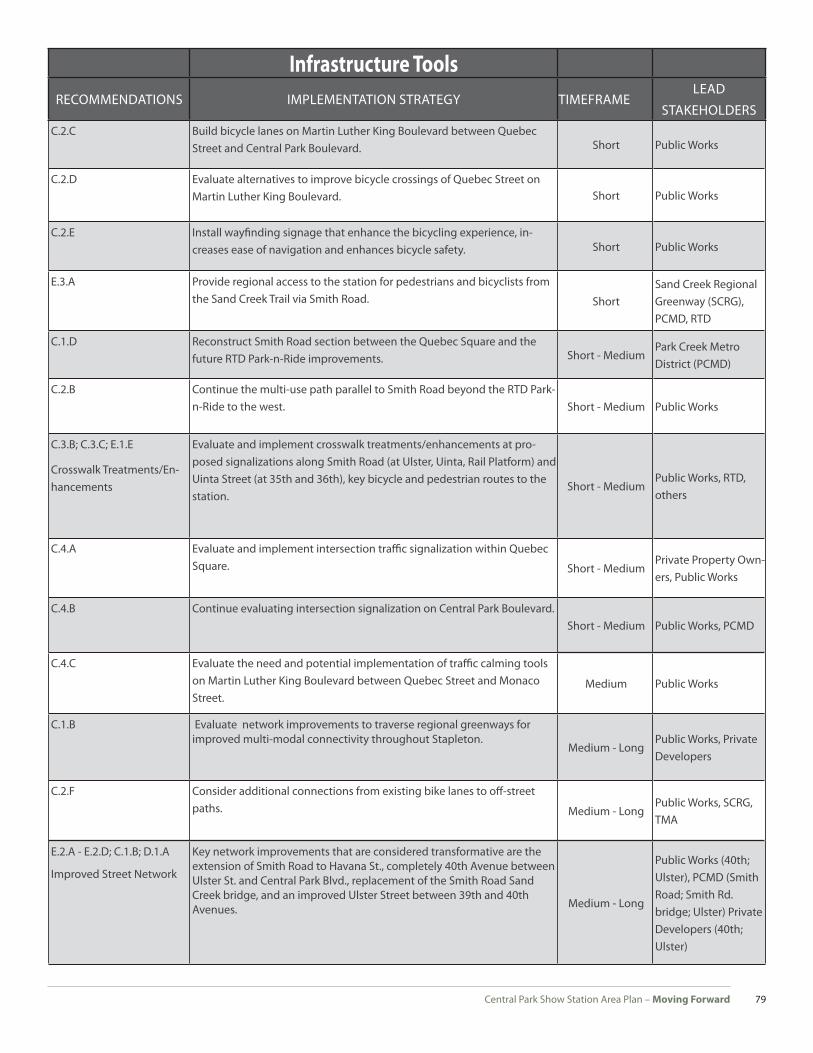
Central Park Show Station Area Plan – Moving Forward 79
Infrastructure Tools
RECOMMENDATIONS IMPLEMENTATION STRATEGY TIMEFRAMELEAD
STAKEHOLDERS C.2.C Build bicycle lanes on Martin Luther King Boulevard between Quebec
Street and Central Park Boulevard. Short Public Works
C.2.D Evaluate alternatives to improve bicycle crossings of Quebec Street on Martin Luther King Boulevard. Short Public Works
C.2.E Install wayfi nding signage that enhance the bicycling experience, in-creases ease of navigation and enhances bicycle safety. Short Public Works
E.3.A Provide regional access to the station for pedestrians and bicyclists from the Sand Creek Trail via Smith Road. Short
Sand Creek Regional Greenway (SCRG), PCMD, RTD
C.1.D Reconstruct Smith Road section between the Quebec Square and the future RTD Park-n-Ride improvements. Short - Medium
Park Creek Metro District (PCMD)
C.2.B Continue the multi-use path parallel to Smith Road beyond the RTD Park-n-Ride to the west. Short - Medium Public Works
C.3.B; C.3.C; E.1.E
Crosswalk Treatments/En-hancements
Evaluate and implement crosswalk treatments/enhancements at pro-posed signalizations along Smith Road (at Ulster, Uinta, Rail Platform) and Uinta Street (at 35th and 36th), key bicycle and pedestrian routes to the station.
Short - MediumPublic Works, RTD, others
C.4.A Evaluate and implement intersection traffi c signalization within Quebec Square. Short - Medium
Private Property Own-ers, Public Works
C.4.B Continue evaluating intersection signalization on Central Park Boulevard.Short - Medium Public Works, PCMD
C.4.C Evaluate the need and potential implementation of traffi c calming tools on Martin Luther King Boulevard between Quebec Street and Monaco Street.
Medium Public Works
C.1.B Evaluate network improvements to traverse regional greenways for improved multi-modal connectivity throughout Stapleton.
Medium - LongPublic Works, Private Developers
C.2.F Consider additional connections from existing bike lanes to off -street paths. Medium - Long
Public Works, SCRG, TMA
E.2.A - E.2.D; C.1.B; D.1.A
Improved Street Network
Key network improvements that are considered transformative are the extension of Smith Road to Havana St., completely 40th Avenue between Ulster St. and Central Park Blvd., replacement of the Smith Road Sand Creek bridge, and an improved Ulster Street between 39th and 40th Avenues. Medium - Long
Public Works (40th; Ulster), PCMD (Smith Road; Smith Rd. bridge; Ulster) Private Developers (40th; Ulster)
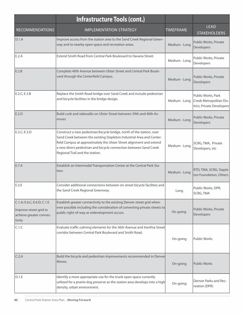
Central Park Station Area Plan – Moving Forward80
Infrastructure Tools (cont.)
RECOMMENDATIONS IMPLEMENTATION STRATEGY TIMEFRAMELEAD
STAKEHOLDERSD.1.A Improve access from the station area to the Sand Creek Regional Green-
way and to nearby open space and recreation areas. Medium - LongPublic Works, Private Developers
E.2.A Extend Smith Road from Central Park Boulevard to Havana Street.Medium - Long
Public Works, Private Developers
E.2.B Complete 40th Avenue between Ulster Street and Central Park Boule-vard through the Centerfi eld Campus.
Medium - LongPublic Works, Private Developers
E.2.C; E.3.B Replace the Smith Road bridge over Sand Creek and include pedestrian and bicycle facilities in the bridge design. Medium - Long
Public Works, Park Creek Metropolitan Dis-trict, Private Developers
E.2.D Build curb and sidewalks on Ulster Street between 39th and 40th Av-enues. Medium - Long
Public Works, Private Developers
E.3.C; E.3.D Construct a new pedestrian/bicycle bridge, north of the station, over Sand Creek between the existing Stapleton Industrial Area and Center-fi eld Campus at approximately the Ulster Street alignment and extend a new direct pedestrian and bicycle connection between Sand Creek Regional Trail and the station.
Medium - LongSCRG, TMA, Private Developers, etc
E.7.A Establish an Intermodal Transportation Center at the Central Park Sta-tion. Medium - Long
RTD, TMA, SCRG, Staple-ton Foundation, Others
E.3.E Consider additional connections between on-street bicycle facilities and the Sand Creek Regional Greenway. Long
Public Works, DPR, SCRG, TMA
C.1.A; E.6.C; E.6.D; C.1.E
Improve street grid to achieve greater connec-tivity
Establish greater connectivity to the existing Denver street grid when-ever possible including the consideration of converting private streets to public right-of-way as redevelopment occurs. On-going
Public Works, Private Developers
C.1.C Evaluate traffi c calming elements for the 36th Avenue and Xanthia Street corridor between Central Park Boulevard and Smith Road.
On-going Public Works
C.2.A Build the bicycle and pedestrian improvements recommended in Denver Moves. On-going Public Works
D.1.E Identify a more appropriate use for the trunk open space currently utilized for a prairie dog preserve as the station area develops into a high density, urban environment.
On-goingDenver Parks and Rec-reation (DPR)

Central Park Show Station Area Plan – Moving Forward 81
Partnership Tools
RECOMMENDATIONS IMPLEMENTATION STRATEGY TIMEFRAMELEAD
STAKEHOLDERSD.2.C
Park-n-Ride Safety
Work to improve the safety of the Park-n-Ride. Consider adding or relocating a COP shop to the station area to improve overall safety of the facility.
Short - MediumCCD Police, RTD, TMA, Others
D.1.D; D.4.C
TOD Marketing Strategy
Promote the walkable, mixed-use environment of the primary TOD area to potential tenants of commercial space and residents of multi-family housing.
Short - Medium RTD, Forest City, Others
E.4.A - B
Station Landmark
Explore fi nancing and implementation strategies to install a station landmark to serve as a visual identity for the station. Short - Medium RTD, Forest City, Others
E.6.F Support any improvements to Quebec Square that increases safe pedes-trian and bicycle access to Quebec Square.
Short - MediumTMA, Stapleton Founda-tion, Private Property Owners, Public Works
E.7.B - E.7.D; E.8
Station Intermodal Trans-portation Center and Bike Programs
The establishment of a Intermodal Transportation Center at Central Park Station creates a centralized point of mobility options for transit users and residents. A station ITC would include bike sharing and rental programs, a bike station, a car sharing program, taxi services, and hotel shuttles.
Short - MediumStapleton Foundation, TMA, RTD, CPD, SCRG, Hotels, Taxi Providers
D.2.H Promote continuing education opportunities.Medium - Long
Stapleton Foundation, Others
D.2.A; D.2.B
Community and Cultural Amenities
Seek an adaptive reuse of the Stapleton Airport Tower in a cultural ame-nity that is accessible to the public. Explore the incorporation of a com-munity gathering facility as part of a larger development jointly utilized by either offi ce and/or residential uses.
On-goingSDC, neighborhood associations, private developers, others
D.2.D - D.2.E
Healthy Food Choices
Encourage healthy food choices by neighborhood residents through urban agriculture, healthy corner store initiatives, and other programs identifi ed by the Sustainable Food Policy Council. Provide healthy food options to waiting transit users and nearby residents by locating mobile food vendors in or near the station area.
On-going; Me-dium
Stapleton Foundation
D.1.A; D.1.B; D.1.C; D.4.E; E.5.B; E.5.C
Sustainable Design
Support green building practices and promote standards of Leader-ship In Energy and Environmental Design (LEED) for new construction beginning with transit facility design and all subsequent development through project review within the City’s and SDC’s design guidelines.
On-goingDevelopment Services, SDC, Forest City
C.6; E.6.B
Parking Management
Evaluate parking patterns and needs within the station impact area as phased development occurs and identify strategies that ensure a proper balance of supply and demand for diff erent users. On-going
Public Works, Stapleton Transportation Man-agement Association (TMA)
D.3.A - D.3.E
Housing Sustainability
Develop aff ordable housing within the station area and throughout Stapleton by partnering with RTD, Forest City, City agencies, and non-profi t housing developers. On-going
RTD, Forest City, OED, Private Developers