Central Coast Sub-Regional Economic Strategy · 3.0 PROFILE OF THE CENTRAL COAST ... APPENDIX C –...
79
rpsgroup.com.au Central Coast Sub-Regional Economic Strategy Prepared by RPS in collaboration with the Wheatbelt Development Commission Funded by Royalties for Regions, State Government of Western Australia
Transcript of Central Coast Sub-Regional Economic Strategy · 3.0 PROFILE OF THE CENTRAL COAST ... APPENDIX C –...

rpsgroup.com.au
Central Coast Sub-Regional Economic Strategy
Prepared by RPS in collaboration with the Wheatbelt Development Commission
Funded by Royalties for Regions, State Government of Western Australia

Valuable support and input to the project was provided by the Central Coast local governments
including:
Shire of Dandaragan
Shire of Gingin
Shire of Chittering
Shire of Coorow
Shire of Moora
Prepared by:
RPS
38 Station Street, SUBIACO WA 6008
PO Box 465, SUBIACO WA 6904
T: 618 9211 1111
F: 618 9211 1122
W: www.rpsgroup.com.au
Report No: PR114067-1
Version/Date: FINAL v1.0 February 2014
Prepared for:
THE WHEATBELT DEVELOPMENT
COMMISSION
298 Fitzgerald Street
NORTHAM WA 6401
RPS Australia East Pty Ltd (ABN: 44140292762)

Central Coast Sub-Regional Economic Strategy
PR114067-1 DRAFT v1.0 July 2013
Document Status
Version Purpose of Document Orig Review Review Date
Format Review
RPS Release Approval
Issue Date
WIP v1.0 WIP draft for initial comment MW SS 28.06.13 28.06.13 28.06.13 28.06.13
DRAFT v1.0 Draft for client review MW SS 28.06.13 28.06.13 28.06.13 28.06.13
DRAFT v2.0 Updated Draft for client review MW SS 23.09.13 23.09.13 23.09.13 23.09.13
FINAL v1.0 Final Draft for Release MW TC 01.02.14 01.02.14 01.02.14 01.02.14
Disclaimer
This document is and shall remain the property of RPS. The document may only be used for the purposes for which it was
commissioned and in accordance with the Terms of Engagement for the commission. Unauthorised copying or use of this
document in any form whatsoever is prohibited.

Central Coast Sub-Regional Economic Strategy
PR114067-1 Final v1.0 February 2014 Page i
SUMMARY
The Central Coast Sub-Region is the Wheatbelt’s coastal economy. Home to 16,288 people in
2011, the Central Coast is a diverse economic region with strong opportunities in food
production and processing, tourism, retirement and lifestyle and light industry and construction.
The key findings of this Strategy, developed by collaboratively RPS and the Wheatbelt
Development Commission and in consultation with the Central Coast LGAs, are illustrated
below.

Central Coast Sub-Regional Economic Strategy
PR114067-1 Final v1.0 February 2014 Page ii
The diversity of geographical, economic and industry drivers of the Central Coast, including its
peri-urban and coastal lifestyle and recent transport infrastructure investments, present
considerable opportunities for major growth in local economic activity and prosperity.

Central Coast Sub-Regional Economic Strategy
PR114067-1 Final v1.0 February 2014 Page iii
This Sub-Regional Economic Strategy for the Central Coast provides economic analysis and
evidence based guidance to assist in investment and decision making and can therefore make a
major contribution to sub-regional and whole-of-region planning. This Strategy also establishes a
framework for the promotion and facilitation of economic and population growth across all towns
in the sub-region.

Central Coast Sub-Regional Economic Strategy
PR114067-1 Final v1.0 February 2014 Page iv
TABLE OF CONTENTS Page
1.0 INTRODUCTION ....................................................................................... 1
1.1 Background ............................................................................................................ 1
1.2 Project Purpose ..................................................................................................... 1
1.3 Central Coast Sub-Region .................................................................................... 1
1.4 Strategy Structure ................................................................................................. 2
1.5 Approach ................................................................................................................ 3
1.6 Glossary and Abbreviations .................................................................................. 4
2.0 THE WHEATBELT’S COASTAL ECONOMY ........................................ 5
2.1 Agriculture, Seafood and Food Consumption .................................................... 5
2.2 Tourism .................................................................................................................. 7
2.3 Renewable Energy ................................................................................................. 8
3.0 PROFILE OF THE CENTRAL COAST ................................................... 10
3.1 Population and Socio-Demographics ................................................................. 10
3.2 Labour Force and Skills ....................................................................................... 11
3.3 Employment, Industry and Investment ............................................................. 12
3.4 Housing and Affordability ................................................................................... 15
3.5 Community Services and Facilities .................................................................... 17
4.0 KEY ECONOMIC OPPORTUNITIES ..................................................... 21
4.1 Aquaculture, Horticulture and Food Processing .............................................. 21
4.2 Renewable Energy ............................................................................................... 27
4.3 Retirement and Lifestyle ..................................................................................... 30
4.4 Mining, Construction and Light Industry........................................................... 34
4.5 Tourism ................................................................................................................ 38
5.0 OPPORTUNITY NETWORK ANALYSIS ............................................. 41
5.1 Outline and Definition ......................................................................................... 41

Central Coast Sub-Regional Economic Strategy
PR114067-1 Final v1.0 February 2014 Page v
5.2 Network Matrix ................................................................................................... 41
5.3 Spatial Analysis .................................................................................................... 42
6.0 ECONOMIC DEVELOPMENT ACTIONS ............................................. 48
APPENDIX A – LOCAL GOVERNMENT PROFILES........................................ 51
APPENDIX B – INDUSTRY VALUE ADDED .................................................... 68
APPENDIX C – SOCIO-ECONOMIC INDICATORS MATRIX ....................... 69
TABLES
Table 1: Current, Projected and Aspirational Population, Central Coast LGAs.............. 11
Table 2: Current, Projected and Aspirational Population, Central Coast LGAs.............. 14
Table 3: House Prices and Growth, Central Coast Sub-Region, 2006 and 2011 ............. 16
Table 4: Hospital Separations and Population, Western Australia, 2010/11/.................... 30
Table 5: Economic Development Actions, Central Coast Sub-Region ............................... 49
Table 6: Industry Value Added and Gross Regional Product, Central Coast,
2010/11 to 2012/13 ......................................................................................................... 68
FIGURES
Figure 1: Sub-Regions, Wheatbelt - overlaid with Local Governments included in
this study ............................................................................................................................... 2
Figure 2: Economic Strategy Structure ........................................................................................... 3
Figure 3: Food Price Index, Real, 1990 to 2012............................................................................ 5
Figure 4: Wheat Stock-to-Use Ratio, 2002/2003 to 2012/12 ................................................... 6
Figure 5: Overnight Visitor, by Source, June 2000 to June 2012 .............................................. 7
Figure 6: Global Energy Usage Mix, 2011 ..................................................................................... 8
Figure 7: Current and Future Residential Population, Central Coast .................................. 10
Figure 8: Unemployment and Participation Rate, Central Coast Sub-Region LGAs,
2011 .................................................................................................................................... 12
Figure 9: Share of Industry Value Add, Central Coast Sub-Region, 2012/13 ..................... 13

Central Coast Sub-Regional Economic Strategy
PR114067-1 Final v1.0 February 2014 Page vi
Figure 10: Share of Locally Registered Businesses, Agriculture, Retail and
Manufacturing, Transport and Logistics, Central Coast Sub-Region LGAs,
2009 .................................................................................................................................... 14
Figure 11: Median House Prices, Central Coast Sub-Region, 2006 and 2011 ...................... 15
Figure 12: Median Multiple, Central Coast Sub-Region, 2011 .................................................. 16
Figure 13: Fertility Rate, Central Coast Sub-Region and Greater Perth, 2011 .................... 18
Figure 14: Share of Residential Population Aged 0-14, Central Coast Sub-Region,
Greater Perth and WA, 2011 ....................................................................................... 18
Figure 15: NAR Farming System Zones (DAFWA 2009) .......................................................... 24
Figure 16: Mid West Energy Project ............................................................................................... 29
Figure 17: Share of Mining Projects by Stage, As At April 2013 .............................................. 34
Figure 18: Major Resource Projects, Western Australia ........................................................... 37
Figure 19: Visitor Nights, Domestic and International, Regional WA, 2000/01 to
2021/22 ............................................................................................................................... 38
Figure 20: Opportunity Network Matrix, Central Coast Sub-Region .................................... 42
Figure 21: Spatial Distribution, Aquaculture, Horticulture and Food Processing,
Central Coast Sub-Region ............................................................................................. 43
Figure 22: Spatial Distribution, Renewable Energy, Central Coast Sub-Region ................... 44
Figure 23: Spatial Distribution, Retirement & Lifestyle, Central Coast Sub-Region ........... 45
Figure 24: Spatial Distribution, Mining & Construction, Central Coast Sub-Region ........... 46
Figure 25: Spatial Distribution, Tourism, Central Coast Sub-Region ..................................... 47

Central Coast Sub-Regional Economic Strategy
PR114067-1 Final v1.0 February 2014 Page 1
1.0 INTRODUCTION
1.1 Background
The Wheatbelt Development Commission sees merit in researching regional centres and their
sub-regions in context to each other, highlighting how the Central Coast functions as a distinct
economic unit. Detailed investigation at the sub-regional level is fundamental given the spatially-
dispersed population and industry profile of the Wheatbelt region.
A sub-regional plan is to be prepared by the Wheatbelt Development Commission for the
Central Coast. This plan is to provide regional context and strategic planning supporting
economic and population growth in the sub-region.
This Strategy complements and builds upon the SuperTowns planning activity undertaken in Jurien
Bay in 2011 and 2012 under the Royalties for Regions Regional Centres Development Plan. The
SuperTowns program was established to assist, diversify and decentralise Western Australia’s
projected population growth by providing attractive alternative residential locations outside of
metropolitan Perth. The Jurien Bay SuperTowns Growth Plan has been endorsed by the
Department of Regional Development, WA Planning Commission and the Infrastructure
Coordinating Committee.
The findings in the sub-regional economic strategies undertaken in the Wheatbelt will significantly
contribute to the inaugural Regional Blueprint Investment Plan that the Wheatbelt Development
Commission is completing in 2014. The Blueprint Investment Plan will outline strategies, areas for
intervention and investment that will drive growth in the Wheatbelt region.
1.2 Project Purpose
RPS was engaged by the Wheatbelt Development Commission to prepare a Sub-Regional
Economic Strategy for the Central Coast. This Strategy is to provide economic analysis and
evidence based guidance to assist in investment and decision making and will therefore make a
major contribution to sub-regional and whole-of-region planning. This Strategy also establishes a
framework for the promotion and facilitation of economic and population growth across all towns
in the sub-region.
1.3 Central Coast Sub-Region
The Wheatbelt Development Commission defines the Central Coast Sub-Region as the Local
Government Areas of Gingin and Dandaragan. This is illustrated in the following Figure 1.
However, for the purpose of this report, the sub-region boundaries have been expanded to
include the Local Government Areas of Coorow, Moora and Chittering. Coorow is located
within the Mid West Development Commission boundaries, however, the coastal towns of
Leeman and Green Head often use Jurien Bay for goods and services. Moora has traditionally held
the sub-regional centre role for this geographic region. This role has changed in prominence as
the economies of the coastal communities have evolved. The statistical profiles in this analysis
demonstrate distinct economic variance between the coastal and inland communities of the
Central Coast. The inclusion of these additional areas, however, is necessary to allow for
statistical analysis to be undertaken for a consolidated economic unit. It also allows for the
existing and potential economic diversity of the broader region to be more appropriately

Central Coast Sub-Regional Economic Strategy
PR114067-1 Final v1.0 February 2014 Page 2
reflected in the indicators and analysis. These areas may also be represented in future economic
strategies for other adjoining sub-regions.
Figure 1: Sub-Regions, Wheatbelt - overlaid with Local Governments included in this study
1.4 Strategy Structure
This Strategy comprises the following key sections:
The Wheatbelt’s Coastal Economy – an overview of key global and national macro-
economic drivers relevant to the Central Coast sub-region.
Profile of the Central Coast Economy – detailed profile of the Central Coast sub-
regional economy including population and socio-demographics, labour force and skills,
employment and industry, housing and affordability and community services and facilities.
Analysis covers each Local Government Area (LGA) and the broader sub-region.
Key Economic Opportunities – identification and summary of key economic
opportunities for the sub-regional strategy including rationale, drivers and trends and sub-
regional characteristics.
Opportunity Network Analysis – identification and analysis of the distribution of
economic competitive advantages and opportunities across towns and LGAs in the
Central Coast.
Action Plan – plan of the actions required to facilitate regional economic development in
the Central Coast sub-region.

Central Coast Sub-Regional Economic Strategy
PR114067-1 Final v1.0 February 2014 Page 3
In addition, concise Local Government profiles, distilling the results of the Strategy for each local
area have been developed and are included in the Appendix. The Strategy’s structure is
illustrated in the following diagram.
Figure 2: Economic Strategy Structure
This structure ensures the flexibility of the Strategy, recognising the various roles and audiences
of the document. These include:
Providing an overall strategy for the economic development of the sub-region;
Informing sub-regional and regional land use and strategic planning activities;
Providing an evidence base for investment prospectuses and funding business cases;
Providing content for marketing and branding material for the sub-region; and
Informing and guiding all levels of Government in major investment and expenditure
decisions.
To meet the requirements of these various audiences, this Strategy has been structured to allow
key sections and analysis to be read and utilised independently of the broader document.
1.5 Approach
This Sub-Regional Economic Strategy has been developed by RPS in partnership with the
Wheatbelt Development Commission. This project has applied the principles of “collaborative
consulting” where the project client is actively involved in the development of the report including
data collection, strategic overview and stakeholder consultation tasks.
This approach is highly advantageous for a number of reasons:
Draws upon the resources of the Development Commission and Local Government to
support data collection and consultation tasks;
Allows the Commission’s unique understanding of the region to be incorporated into the
Strategy;
THE WHEATBELT’S COASTAL ECONOMY
PROFILE OF THE CENTRAL COAST ECONOMY
KEY ECONOMIC OPPORTUNITIES OPPORTUNITY NETWORK
ANALYSIS
ACTION PLAN
LOCAL GOVERNMENT PROFILES

Central Coast Sub-Regional Economic Strategy
PR114067-1 Final v1.0 February 2014 Page 4
Ensures value for money for the client by allowing RPS to concentrate on more detailed
modelling and strategic analysis tasks; and
Enables strategic and objective analysis to be undertaken by RPS, ensuring the Strategy’s
evidence base is rigorous, independent and suitable to inform investment decision and
funding business cases.
1.6 Glossary and Abbreviations
ABS Australian Bureau of Statistics
ABARES Australian Bureau of Agricultural and Resource Economics and
Services
BREE Bureau of Resource and Energy Economics
BOM Bureau of Meteorology
CRC Community Resource Centre
GFC Global Financial Crisis
GRP Gross Regional Product
LGA Local Government Area
Median Multiple Ratio measure of housing affordability. Represents the number of
years of median household income required to equate to median
house prices in an area.
RBA Reserve Bank of Australia
Separation An episode of care for an admitted patient, which can be a total
hospital stay (from admission to discharge, transfer or death), or
a portion of a hospital stay beginning or ending in a change of
type of care (for example, from acute to rehabilitation).
T/Ha Tonnes per Hectare
WAPC Western Australian Planning Commission
WDC Wheatbelt Development Commission

Central Coast Sub-Regional Economic Strategy
PR114067-1 Final v1.0 February 2014 Page 5
2.0 THE WHEATBELT’S COASTAL ECONOMY
The Central Coast Sub-Region of the Wheatbelt is diverse. It is characterised by a unique
combination of coastal, agricultural and historical natural and urban environments that underpin a
diverse economic base including international and domestic tourist attractions, broadacre
agriculture, horticulture and commercial fisheries and non-core mineral mining. This diversity of
activity means that the future economic development of the Central Coast economy will be
influenced by a wide range of global socio-economic trends including but not limited to;
Agriculture, Seafood and Food Consumption
Tourism
Renewable Energy
2.1 Agriculture, Seafood and Food Consumption
The Central Coast Sub-Region is a diverse agricultural region, producing a wide range of base and
premium food products for local and global markets. It possesses unique natural
coastal/oceanographic and land characteristics that have the potential to support significant
increases in local production. Global food production will need to increase by 60% by 2050 to
meet projected demand levels1. At the same time, global food production is projected to grow at
only 1.7% per annum over the next 10 years, as a combination of increased resource competition
from biofuel sectors and increased environmental protections constrain production. Demand is
already outpacing supply in international markets, with food price volatility increasing dramatically
since 2006 and prices trending upwards from 2000 lows, after decades of real food price declines
resulting from increased productivity. These spikes were associated by a combination of factors
including increased composition for food stuff in the production of biofuels and the impact of
weather events on global production. This is illustrated below.
Figure 3: Food Price Index, Real, 1990 to 20122
Net food exporters like Australia are therefore uniquely positioned to meet the needs of
domestic and international markets, through continued and increased production of agriculture,
horticulture and aquaculture products.
1 FAO (2012), OECD-FAO Agricultural Outlook 2012, Food and Agriculture Organisation, Rome Italy 2 FAO (2012), Food Price Index – August 2012, Food and Agriculture Organisation, Rome Italy
80
90
100
110
120
130
140
150
160
170
180
1/1
99
0
11
/19
90
9/1
99
1
7/1
99
2
5/1
99
3
3/1
99
4
1/1
99
5
11
/19
95
9/1
99
6
7/1
99
7
5/1
99
8
3/1
99
9
1/2
00
0
11
/20
00
9/2
00
1
7/2
00
2
5/2
00
3
3/2
00
4
1/2
00
5
11
/20
05
9/2
00
6
7/2
00
7
5/2
00
8
3/2
00
9
1/2
01
0
11
/20
10
9/2
01
1
7/2
01
2
Foo
d P
rice
Ind
ex (
Re
al)

Central Coast Sub-Regional Economic Strategy
PR114067-1 Final v1.0 February 2014 Page 6
Currently the Central Coast Sub-Region’s coastal strip is most recognised for its crayfish capture
sector, which exports its product to USA, Japan and other markets. The coastal environment has
also been recognised as a highly attractive environment for fish farming and other forms of
intensive aquaculture. Fish and seafood is a major component of global food consumption and is
particularly favoured in many emerging Asian economies. The increased need for protein in
developing countries, driven by increases in both population and income levels, has underpinned
this growth and is expected to support a 15% growth in seafood consumption over the next 10
years3. However, aquaculture production is expected to grow by 33% over the period, with
aquaculture now projected to surpass capture fisheries as the primary source of fish for human
consumption by 20184. This transition is being supported by stronger price rises in aquaculture
products than capture fisheries products, reflecting greater certainties of product supply and
quality. The proximity of Western Australia to key markets provides the State with a distinct
competitive advantage over other parts of Australia and the existence of world-recognised
fisheries management, licensing and quality control regimes reinforces Australia’s position as a
high quality aquaculture supplier.
Non-coastal areas in Gingin, Dandaragan, Chittering, Moora and Coorow produce a wide mixture
of products including broadacre grains, animal husbandry (including horses, sheep and cattle all on
pasture), fruit crops and horticulture. Currently, broadacre grains are experiencing considerable
price growth on international markets due to seasonal volatility in major producers (such as the
USA and Australia) and continued declines in stock-to-use ratios (illustrated in the following
diagram). This is expected to continue in the medium term, despite the emergence of new
production regions in Russia, Ukraine and other central Asian countries.
Figure 4: Wheat Stock-to-Use Ratio, 2002/2003 to 2012/125
Comparatively strong water supply security in the Central Coast’s agricultural areas is a key
advantage of the region. This presents opportunities, not only for increased base agricultural
production, but also water intensive processing value adding, drawing on production across the
3 FAO (2012), OECD-FAO Agricultural Outlook 2012, Food and Agriculture Organisation, Rome Italy 4 FAO (2012), OECD-FAO Agricultural Outlook 2012, Food and Agriculture Organisation, Rome Italy 5 FAO (2012), Grain Supply and Demand, Food and Agriculture Organisation, Rome Italy. The Stock to Use ratio is a
convenient measure of the short-term supply and demand position of commodity markets. The higher the ratio of
stock to use, the more wheat there is in storage to meet demand.
20.0%
22.0%
24.0%
26.0%
28.0%
30.0%
32.0%
34.0%
36.0%
2002/03 2004/05 2006/07 2008/09 2010/11 2012/13
Wh
eat
Sto
ck t
o U
se R
atio
(%
)

Central Coast Sub-Regional Economic Strategy
PR114067-1 Final v1.0 February 2014 Page 7
entire Wheatbelt region. The future of this industry in the sub-region will be heavily reliant on
future draw down and licence allocation for the underground water aquifers6.
2.2 Tourism
Long recognised as the Wheatbelt’s “Playground”, the Central Coast Sub-Region has a wide
variety of domestic day-trip, overnight and international tourism destinations that underpin local
tourism activity. Tourism has experienced a challenging decade, with domestic overnight visitation
depressed by increased attractiveness of outbound overseas travel (due to higher Australian
Dollar and increased outbound flights) and recent domestic and global economic uncertainty and
associated consumer caution7. Additionally, difficulties nationally, and in particular in Western
Australian markets, regarding the feasibility of tourism establishment development and operation
are constraining potential diversification and growth of overnight visitor numbers.
Figure 5: Overnight Visitor, by Source, June 2000 to June 20128
As illustrated in the figure above, domestic overnight visitation in WA declined considerably
between 2007 and 2010, though has recently rebounded from GFC lows. However, despite global
uncertainty and volatility, international visitation to WA grew rapidly, albeit off a smaller base. The
emergence of middle classes in major emerging and developing countries, particularly in greater
Asia, more than offset declines in visitor numbers from existing, now economically depressed
markets of Europe and the US.
The tourism sector can have a positive multiplier effect by:
Providing employment opportunities, both skilled and unskilled being a labour intensive
industry;
Increasing local income and creates increased gross national product;
Growth in this sector requires the development of new infrastructure that will also help
to stimulate local commerce and creative industry;
Creating new facilities that can be used by the local population also;
6 Department of Water (2013) Gingin Groundwater Allocation Plan [draft], Water Resource Allocation and Planning
Report Series, report no. 53, Perth; Department of Water (2010) Jurien Groundwater Allocation Plan, Water Resource
Allocation Planning Series, report no. 27, Perth. 7 Tourism Australia (2011) Tourism 2020 Strategy, Tourism Australia, Canberra 8 TRA (2012), Online NVS and IVS Data, Tourism Research Australia, Canberra
0
1,000,000
2,000,000
3,000,000
4,000,000
5,000,000
6,000,000
7,000,000
8,000,000
2000 2001 2002 2003 2004 2005 2006 2007 2008 2009 2010 2011 2012
Vis
ito
r
Domestic Overnight Visitors International Visitor

Central Coast Sub-Regional Economic Strategy
PR114067-1 Final v1.0 February 2014 Page 8
Justifying environmental protection and improvement due to the rise of nature-based
tourism
The Central Coast sub-region is a diverse tourism market. Locations such as Gingin and Bindoon
townships, with their peri-urban location and agrarian/natural amenities are major destinations for
day-trip visitors from metropolitan Perth. Conversely, coastal nodes of Lancelin, Guilderton,
Cervantes, Jurien Bay and surrounding areas have very high concentrations of holiday and second
homes, acting as peak period holiday destinations for intra and inter-state visitors. This reflects
the combination of coastal, historical and natural amenities. The region also contains a major
international tourism attraction in the form of the Pinnacles rock formation. This does not
however, appear to underpin strong international overnight visitation to the region, with its
relative accessibility from metropolitan Perth and a lack of high quality, internationally oriented
tourism accommodation constraining overseas visitor capture.
2.3 Renewable Energy
Australia has one of the highest rates greenhouse gas emissions per capita in the world9. This
reflects a combination of the country’s high standard of living and the fossil fuel dominance of our
base load electricity generation mix. Renewable energy production is increasing globally, in
response to both climate change and energy security concerns. While per capita energy
production in OECD countries has declined in recent years, due to depressed economic activity
and enhancements in energy efficiency, this has been more than offset by rapid increases in energy
usage in developing regions including the Middle East, China, South East Asia, Central Europe and
Latin America10. Like Australia, global energy consumption is dominated by fossil fuels, with a
market share in 2011 of 87%. This includes both base load power and transport fuel energy use.
In contrast, renewable energy contribution is at 2%, or some 194.8 of 12,274.4 million tonnes of
oil equivalent. This increases to 8% when hydroelectricity is included, as illustrated in the figure
below.
Figure 6: Global Energy Usage Mix, 2011 11
The adoption and incorporation of renewable energy resources into energy mixes varies
dramatically across the world. Countries such as Germany, Spain, China, India, Brazil and the US
9 AGO (2012), Australian Greenhouse Office website accessed at http://www.climatechange.gov.au/ on 13/09/2012 10 BP (2012) Statistical Review of World Energy, June 2012, BP, London 11 BP (2012) Statistical Review of World Energy, June 2012, BP, London
Oil33%
Natural gas24%
Coal30%
Nuclear energy5%
Hydro electricity6%
Renewables2%

Central Coast Sub-Regional Economic Strategy
PR114067-1 Final v1.0 February 2014 Page 9
have and continue to invest heavily in renewable energy resources, which is reflected in above
average shares of renewable energy in North American, European and Central Asian markets12.
Even within renewable energy, there are regional variations within the US. This is primarily in the
form of wind power and biofuels, while Germany’s production is dominated by solar energy.
In contrast, Australia’s share of global renewable energy markets is only 1.1%, despite having a
wide range of latent natural renewable energy resources. The Central Coast sub-region has been
recognised as a major potential producer of renewable energy in Australia, with its coastal
orientation underpinning wind power generation capacity. Emu Downs Wind Farm opened in the
Shire of Dandaragan in 2006 and is now owned by the APA Group. The success of the project
and associated demonstration of the local resource’s consistency and alignment with peak power
usage periods has underpinned plans for three further wind farms in the area13.
12 BP (2012) Statistical Review of World Energy, June 2012, BP, London 13 Shire of Dandaragan (2012), Development Update (as at April 2012), Shire of Dandaragan, Jurien Bay

Central Coast Sub-Regional Economic Strategy
PR114067-1 Final v1.0 February 2014 Page 10
3.0 PROFILE OF THE CENTRAL COAST
3.1 Population and Socio-Demographics
The Central Coast Sub-Region was home to 16,228 people in 2011 across the five LGAs14. This
population is primarily concentrated in the major townships of Gingin, Jurien Bay, Moora,
Bindoon, Cervantes and Lancelin and locality of Lower Chittering.
The sub-region has experienced only moderate population growth over the past decade,
averaging 1.3% per annum compared to 2.1% for Western Australia as a whole. The strongest
growth over this period was in the Chittering LGA, which grew 54% during the decade to 2011 at
4.4% per annum. This is more than three times faster than the sub-region as a whole.
The WA Tomorrow Population Estimates from the Western Australian Planning Commission
project that this growth will accelerate, with another 3,500 residents predicted to call the Central
Coast home by 202115, with the majority of this growth expected to continue to be located in
Chittering. However, this likely understates the population and residential growth potential of the
region for a range of factors:
Recent identification of Jurien Bay as a SuperTown by the Department of Regional
Development and the associated planning and funding support designed to facilitate
increased residential population in the town;
The potential of the Central Coast Sub-Region to attract employment-yielding
investments, coupled with a low unemployment rate, has the potential to accelerate in-
migration-based population growth; and
Affordability and proximity factors make the Central Coast Sub-Region highly attractive
to Baby Boomers seeking to cash-out their equity to fund their retirement and relocate
to a more rural setting. This is assisted with the availability of significant areas of zoned
residential land.
Figure 7: Current and Future Residential Population, Central Coast
14 ABS (2011), Estimated Residential Population, Cat No 3218.0, Australian Bureau of Statistics, Canberra 15 WAPC (2012), WA Tomorrow Population Estimates, Western Australian Planning Commission, Perth
16,22819,710
26,750
0
5,000
10,000
15,000
20,000
25,000
30,000
2011 2021 (WAPC) 2021 (Aspirational)
Esti
mat
ed
Re
sid
en
tial
Po
pu
lati
on

Central Coast Sub-Regional Economic Strategy
PR114067-1 Final v1.0 February 2014 Page 11
Instead, population target of 26,750 by 2021 is regarded as more aspirational and suitable for this
Strategy. This would involve accelerated growth across all LGAs, reversing the decline projected
by the WAPC for Coorow LGA and reinforcing Chittering’s role as the largest LGA in the sub-
region. Individual aspirational population targets are outlined in the table below.
Table 1: Current, Projected and Aspirational Population, Central Coast LGAs
Population Dandaragan Gingin Moora Coorow Chittering
2011 3,277 4,801 2,550 1,091 4,509
2021 (WAPC) 4,000 5,400 2,400 710 7,200
2021 (Aspirational) 5,000 6,500 3,500 2,250 9,500
It is important to recognise that theoretical residential land supplies in the Central Coast are less
than would be indicated by the region’s spatial size. The dominance of national and state parks
and A Class reserves along the coastal strip means that, north of Guilderton, there is a clear
spatial break in potential residential growth north of metropolitan Perth until reaching Jurien Bay
(with local expansion in Cervantes constrained by national park, reflecting its historical origins). In
contrast, Jurien Bay and rural areas adjacent to the metropolitan area (e.g. Gingin and Chittering)
appear to have substantial areas of freehold land, either developed or planned for development.
It is accepted that coastal and high amenity rural lifestyle areas will continue to be desirable to
retirees. There is also a mixture of zoned and development ready residential land in the
townships of Moora, Leeman and Bindoon.
The population of the Central Coast Sub-Region is expected to age rapidly over the next decade.
This reflects the fact the sub-region and associated population centres already possess older
population profiles compared to the rest of the Wheatbelt and Western Australia. According to
the results of the 2011 Census of Population and Housing, the residential populations of coastal
LGAs in the Central Coast sub-region have higher proportions of people aged 65+ than the State
Average (12.2%), with more than one sixth of their current populations aged 65 and over.
However, inland LGAs are decidedly younger, with Moora and Chittering having current 65+
population shares comparable with the State Average (at 12.7%)16.
3.2 Labour Force and Skills
A significant driver of current and future residential population growth in the Central Coast is the
increasingly constrained nature of local labour markets. In 2011, the Central Coast region had an
average annual unemployment rate of 2.0%, below the comparative state average of 4.1% in 2011.
In fact, all LGAs in the sub-region had an unemployment rate below 2.6% in 2011.
16 ABS (2012), Census of Population and Housing, 2011, Australian Bureau of Statistics, Canberra

Central Coast Sub-Regional Economic Strategy
PR114067-1 Final v1.0 February 2014 Page 12
Figure 8: Unemployment and Participation Rate, Central Coast Sub-Region LGAs, 201117
This low unemployment has supported strong labour force participation rates compared to the
State average (67.7%). The Moora and Coorow LGAs’ participation rates were significantly higher
in 2011 (86.7% and 90.3% respectively), while the LGAs of Dandaragan, Gingin and Chittering
have rates more comparable with the State average (68.7%, 62.6% and 65.1% respectively). This
reflects the concentration of the sub-region’s population and labour force in these areas, meaning
local labour markets have normalised. Given the low unemployment rates of the sub-region, the
combination of employment opportunities and coastal and lifestyle amenity means accelerating
sub-regional population growth and migration should not be a difficult task.
3.3 Employment, Industry and Investment
The Central Coast Sub-Region had a Gross Regional Product18 in 2012/13 of approximately
$684m19. The major drivers of this economic activity are agriculture and fishing activities and
associated transport, logistics and manufacturing, which accounts for 40% of the local economy.
Construction and Mining activity accounts for a further quarter. This is illustrated in the figure
below.
17 DEEWR (2012), Small Area Labour Market Model, Commonwealth Government, Canberra 18 Gross Regional Product is the value of the economic activity produced in the region, discounting for inputs produced
in other regions. It aligns with measures such as Gross State Product and Gross Domestic Product for States and
Territories. 19 RPS (2012), RPS Economics Gross Regional Product Model, RPS, Gold Coast
0.0%
0.3%
0.6%
0.9%
1.2%
1.5%
1.8%
2.1%
2.4%
2.7%
3.0%
50%
55%
60%
65%
70%
75%
80%
85%
90%
95%
100%
Dandaragan Gingin Chittering Moora Coorow CentralCoast
Un
em
plo
yme
nt
Rat
e
Lab
ou
r Fo
rce
Par
tici
pat
ion
Rat
e
Participation Rate (2011) Unemployment Rate (2011)

Central Coast Sub-Regional Economic Strategy
PR114067-1 Final v1.0 February 2014 Page 13
Figure 9: Share of Industry Value Add20, Central Coast Sub-Region, 2012/13
This economic activity has underpinned local employment and business activity. In 2011, there
were 5,497 jobs in the Central Coast Sub-Region, representing an employment self-sufficiency
rate (ESS - ratio of local jobs to local workers) of 76%21. This is a strong ESS rate for a region
located directly adjacent the metropolitan Perth area with its associated economic gravity.
Employment in the Central Coast is relatively distributed across major centres with between
1,000 and 1,500 jobs in each of Chittering, Dandaragan, Gingin and Moora LGAs. Interestingly,
this more even employment distribution does not mirror the population distribution of the
region, reflecting concentrations of older population cohorts (not in the labour force) in the
coastal LGAs of Dandaragan and Gingin.
A review of business registrations data for the sub-region reveals a significantly different industry
composition than indicated by Gross Regional Product analysis. In 2009, agriculture and fisheries
businesses accounted for 44% of locally registered businesses, despite accounting for 17% of
industry value add22. In contrast, the Transport, Logistics and Manufacturing sector accounts for
8.8% of locally registered businesses but collectively contributes 21% of sub-regional value add.
20 Industry value added is the primary component of Gross Regional Product, excluding only the Ownership of
Dwellings, Taxes and Subsidies and Statistical Discrepancies. It represents the component of GRP associated with
production and value added by businesses and industries within the economy excluding inputs to product imported
from other regions. Refer to Appendix B for the Industry breakdown of Value Add in the Central Coast economy. 21 ABS (2012), Census of Population and Housing 2011, Australian Bureau of Statistics, Canberra 22 ABS (2010), Count of Businesses, Cat No 8165.0, Australian Bureau of Statistics, Canberra
Agriculture, forestry & fishing
17%
Mining16%
Manufacturing, Transport and
Logistics21%
Construction17%
Other29%
Central Coast Sub-Regional Economic Strategy
PR114067-1 Final v1.0 February 2014 Page 14
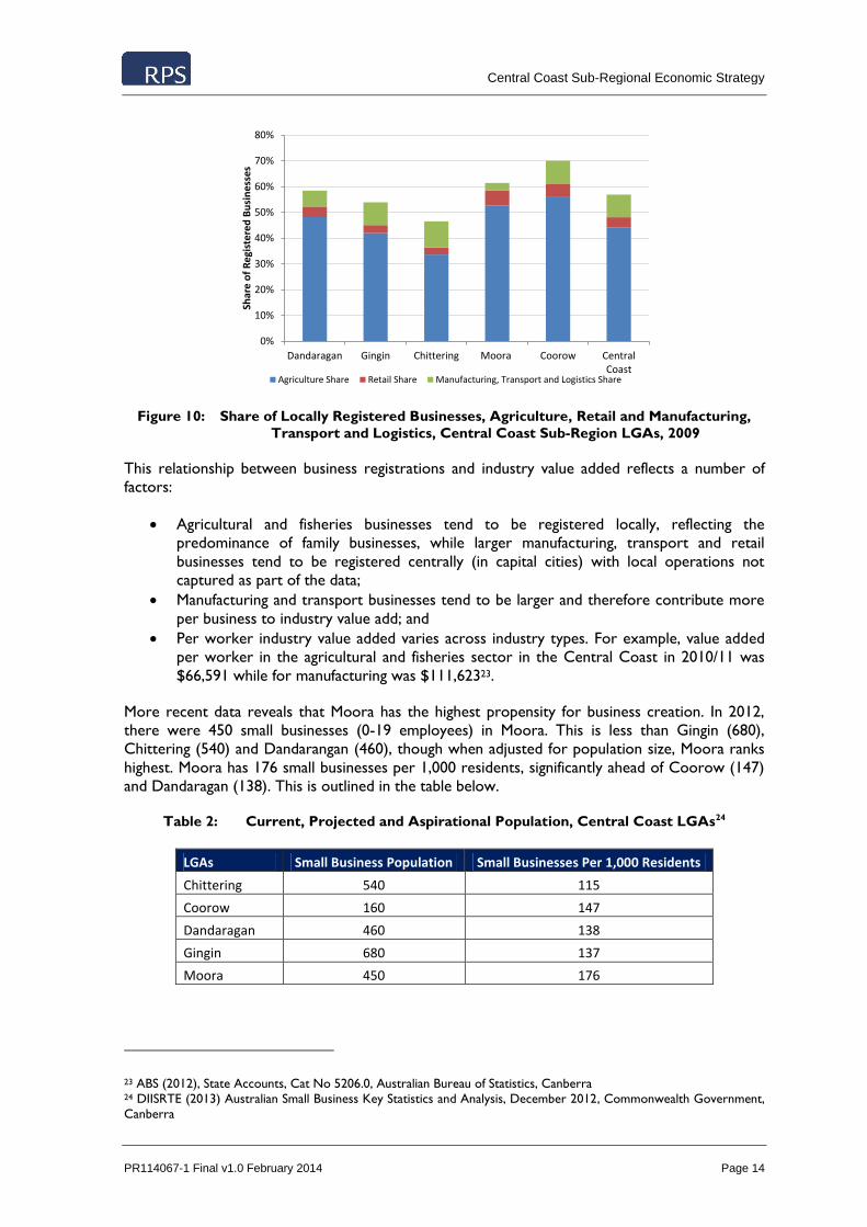
Figure 10: Share of Locally Registered Businesses, Agriculture, Retail and Manufacturing,
Transport and Logistics, Central Coast Sub-Region LGAs, 2009
This relationship between business registrations and industry value added reflects a number of
factors:
Agricultural and fisheries businesses tend to be registered locally, reflecting the
predominance of family businesses, while larger manufacturing, transport and retail
businesses tend to be registered centrally (in capital cities) with local operations not
captured as part of the data;
Manufacturing and transport businesses tend to be larger and therefore contribute more
per business to industry value add; and
Per worker industry value added varies across industry types. For example, value added
per worker in the agricultural and fisheries sector in the Central Coast in 2010/11 was
$66,591 while for manufacturing was $111,62323.
More recent data reveals that Moora has the highest propensity for business creation. In 2012,
there were 450 small businesses (0-19 employees) in Moora. This is less than Gingin (680),
Chittering (540) and Dandarangan (460), though when adjusted for population size, Moora ranks
highest. Moora has 176 small businesses per 1,000 residents, significantly ahead of Coorow (147)
and Dandaragan (138). This is outlined in the table below.
Table 2: Current, Projected and Aspirational Population, Central Coast LGAs24
LGAs Small Business Population Small Businesses Per 1,000 Residents
Chittering 540 115
Coorow 160 147
Dandaragan 460 138
Gingin 680 137
Moora 450 176
23 ABS (2012), State Accounts, Cat No 5206.0, Australian Bureau of Statistics, Canberra 24 DIISRTE (2013) Australian Small Business Key Statistics and Analysis, December 2012, Commonwealth Government,
Canberra
0%
10%
20%
30%
40%
50%
60%
70%
80%
Dandaragan Gingin Chittering Moora Coorow CentralCoast
Shar
e o
f R
egi
ste
red
Bu
sin
ess
es
Agriculture Share Retail Share Manufacturing, Transport and Logistics Share

Central Coast Sub-Regional Economic Strategy
PR114067-1 Final v1.0 February 2014 Page 15
3.4 Housing and Affordability
The Central Coast Sub-Region housing market is comprised of over 10,000 dwellings. However,
the defining feature of the sub-region’s housing market is the share of unoccupied dwellings,
which represent 41.8% of stock in 2011. This is considerably more than the unoccupied share of
dwellings in Western Australia (12.1%), reflecting the predominance of second and/or holiday
homes and residences in the coastal LGAs of Dandaragan, Gingin and Coorow25. In contrast, the
housing stock in Moora and Chittering LGAs have a more traditional occupancy rate, with only
14.7% and 17.6% unoccupied on Census night respectively.
Over the past five years, the Central Coast Sub-Region and the broader Western Australian
housing market has experienced volatile conditions, with prices both rising and falling during the
period. This reflects the impact that the GFC and subsequent depressed level of consumer
confidence has had on housing market activities and therefore prices. House price growth has
been slow over the past five years, growing only 5% since 2006. This is below Perth and WA
growth levels (16% and 15% respectively)26. This reflects a combination of factors.
Firstly, the entirety of price growth in the sub-region since 2006 was experienced in 2007 and was
partly reversed in 2008. Since then, prices have been broadly flat. This is illustrated in the figure
below.
Figure 11: Median House Prices, Central Coast Sub-Region, 2006 and 2011
Secondly, price levels and movements have varied across the LGAs that comprise the Central
Coast. Price points are generally higher and have experienced greater levels of volatility in the
coastal LGAs of Gingin and Dandaragan, and to a lesser extent in Coorow. Prices have fallen in
Gingin LGA (12% between 2006 and 2010); while prices have increased in Moora LGA by 46%
over the same period (though off a base less than a quarter of that of Dandaragan and Gingin
LGAs). These spatial variations in prices are outlined in the following table.
25 ABS (2012), Census of Population and Housing 2011, Australian Bureau of Statistics, Canberra 26 RPData (2012), Online Data Subscription, RPData, Brisbane
$320,000
$330,000
$340,000
$350,000
$360,000
$370,000
$380,000
$390,000
$400,000
$410,000
2006 2007 2008 2009 2010 2011
Me
dia
n H
ou
se P
rice

Central Coast Sub-Regional Economic Strategy
PR114067-1 Final v1.0 February 2014 Page 16
Table 3: House Prices and Growth, Central Coast Sub-Region, 2006 and 201127
Indicators Dandaragan Gingin Chittering Moora Coorow Central Coast Perth WA
2006 $382,500 $430,000 $380,000 $86,500 $327,500 $348,250 $406,000 $382,000
2011 $420,000 $380,000 $505,000 $126,250 $335,000 $365,000 $469,000 $440,000
Growth $37,500 -$50,000 $125,000 $39,750 $7,500 $16,750 $63,000 $58,000
Growth (%) 10% -12% 33% 46% 2% 5% 16% 15%
Prices have moved again since 2011 with slight falls in Dandaragan, Chittering and Coorow and
growth in Gingin. This highlights the volatility in annual house prices in the area.
This combination of factors highlights the fact that the Central Coast housing markets generally,
and the coastal towns of Lancelin, Cervantes, Jurien Bay and Green Head in particular, have
strong exposures to national trends in holiday homes, second homes and holiday rentals. House
markets with such exposure – usually in high amenity coastal locations – experienced robust price
growth during the mid 2000’s on the back of increased debt availability and the attractiveness of
such locations to “empty nesters” (older couples without children households) and Baby Boomers
(people born 1946 to 1964) as overnight leisure destinations. However, with the onset of the
GFC and the retirement of the early parts of the Baby Boomer generation, such holiday/leisure
nodes have experienced decreased housing demand and flat or even negative price growth.
Figure 12: Median Multiple, Central Coast Sub-Region, 2011
Moderate price growth is generally regarded as positive as it contributes to the wealth and
affluence of a region. However, for the Central Coast Sub-Region, with its relative proximity to
Perth, offering affordable housing options is critical to underpinning employment and lifestyle
based migration required to increase local population critical mass. A simple and effective
measure of whole-of-market affordability is the Median Multiple – the ratio of median house
prices to median household income28. In other words, the Median Multiple illustrates the number
of years of household income required to equal current prices. This approach is effective in that it
27 RPData (2012), Online Unpublished Data, RPData, Brisbane 28 Demographia (2012), International Affordable Housing Report 2012, Demgoraphia, USA
0
1
2
3
4
5
6
7
8
9
Dandaragan Gingin Chittering Moora Coorow WA
Rat
io o
f M
ed
ian
Ho
use
Pri
ce t
o M
ed
ian
H
ou
seh
old
Inco
me

Central Coast Sub-Regional Economic Strategy
PR114067-1 Final v1.0 February 2014 Page 17
allows for differences in local income levels within a region – like the Central Coast – to be
considered, ensuring that variations in purchasing power and relative affordability are determined.
RPS calculated the Median Multiple for each LGA in the Central Coast sub-region and found that,
with the exception of Moora LGA, all Shires have Median Multiple ratios well above the WA
average of 6.0. These markets are regarded as some of the most severely unaffordable in the
State, in spite of moderately high incomes compared to other locations in the Wheatbelt.
Interestingly, Chittering has only a slightly lower ratio than Gingin and Dandaragan, despite having
a substantially higher income. Moora LGA on the other hand is regarded as highly affordable, with
low house prices and the highest household incomes in the region supporting a Median Multiple
ratio of 2.1.
A major driver of this trend is the fact that the Central Coast is a recognised retirement
destination. As such, older households, mostly living in Perth, seek to cash out of the family home
and relocate to coastal towns north of the city. This has the dual effect of bidding up local house
prices (because of the higher home values in Perth), and decreasing average incomes (due to the
asset rich cash poor nature of older Baby Boomers).
3.5 Community Services and Facilities
The growth in the residential population in the Central Coast has and will continue to underpin
demand for community services and facilities in the sub-region. This includes, but is not limited to:
Child care services;
Primary, secondary and tertiary education;
Libraries and Community Resource Centres;
Aged Care and retirement villages; and
Hospitals and health services.
The current offering and drivers of these community services and facilities are examined below.
3.5.1 Child Care
Fertility rate data is an effective leading indicator of the level of demand for child care services. In
2010, all towns in the Central Coast Sub-Region had fertility rates above replacement levels (2.1
children) and were well above the average for Greater Perth (1.929). This is illustrated in the
figure below.
29 ABS (2011), Births Australia, Cat No 3301.0, Australian Bureau of Statistics, Canberra

Central Coast Sub-Regional Economic Strategy
PR114067-1 Final v1.0 February 2014 Page 18
Figure 13: Fertility Rate, Central Coast Sub-Region and Greater Perth, 2011
This moderately high fertility rate, coupled with low unemployment and moderate labour force
participation, will generate demand for child care services. There are currently 5 child care
centres in the Central Coast sub-region, located in Dandaragan (1), Chittering (2), Moora (1) and
Gingin (1). This distribution is more spread than the concentration of population, reflecting the
more even distribution of young children compared to the total population with the Central
Coast (due to higher concentrations of older residents in coastal LGAs).
3.5.2 Primary, Secondary and Tertiary Education
Despite the ageing of the population in the Central Coast, many towns in the sub-region also have
above average shares of residents aged 0-14. This reflects the long-term impact on the Central
Coast’s demographic profile of structurally high fertility rates, as well as migration to the region of
young families. A review of the results of the recent Census reveals that, with the exception of
Coorow, all other LGAs in the sub-region have 0-14 shares equal to or above the average for
Greater Perth.
Figure 14: Share of Residential Population Aged 0-14, Central Coast Sub-Region, Greater
Perth and WA, 2011
0.0
0.5
1.0
1.5
2.0
2.5
3.0
Dandaragan Gingin Chittering Moora Coorow Central Coast Perth
Fert
ility
Rat
e
15%
16%
17%
18%
19%
20%
21%
22%
23%
Dan
daragan
Gin
gin
Mo
ora
Co
oro
w
Ch
ittering
Cen
tral Co
ast
Greater P
erth
WA
Shar
e o
f R
esi
de
nti
al P
op
ula
tio
n

Central Coast Sub-Regional Economic Strategy
PR114067-1 Final v1.0 February 2014 Page 19
There are currently 11 primary schools in the Central Coast sub-region. Primary school
distribution is relatively dispersed, with all LGAs having a number of primary schools, though
student numbers vary considerably (total of 1,008 primary school students in the Central Coast
Sub-Region)30.
Secondary school distribution is more concentrated with district high schools located in Jurien
Bay (320 students) and Gingin (438 students), and a senior high school and residential college in
Moora (183 students). There is one private secondary school in the sub-region, being Catholic
Agricultural College Bindoon (149 students). The provision of secondary schooling in the Central
Coast is critical to the attraction and retention of working age families necessary to support local
economic development. Increased residential population will underpin demand for increased size
and diversity of local secondary education provision. Students from towns with a close proximity
to the metro area in the Shires of Chittering and Gingin (e.g Gingin, Lancelin, Bindoon) are
accessing high school education at public and private schools in the northern and eastern suburbs,
commuting daily on privately chartered buses.
The labour force in the Central Coast Sub-Region is characterised by an expected concentration
of applied tertiary education qualifications (i.e. formal training and TAFE). This is reflected both in
the local employment mix but also local tertiary education provision. The C.Y. O’Connor
Institute is the primary tertiary education and training facility in the Wheatbelt region with
locations in Northam, Merredin, Moora, Narrogin and Muresk31. A wide range of practical
courses are offered with a strong focus on administration, tourism, health, agricultural and
manufacturing related qualifications. Opportunities exist to strategically diversify offerings into
mining-related occupations to support increased cross-industry mobility of the Central Coast
labour force, in response to macro-economic opportunities and decreased unemployment levels.
3.5.3 Libraries and Community Resource Centres
In 2011 in metropolitan Perth, there was one library for every 22,582 residents equating to a total
supply of 77 libraries. The provision of libraries and associated facilities in the Central Coast is
more considerable with one library for every 1,475 residents. There are a number of potential
explanations for this apparent over-provision:
The decentralised and distributed population of the Central Coast has required a more
dispersed library network than in metropolitan Perth;
The number of libraries doesn’t comment on the size and service capabilities of those
libraries. Metropolitan libraries tend to be larger and therefore have the capacity to
service larger population catchments; and
Libraries are most often provided by local governments. Every LGA in Central Coast is
home to at least one library.
Libraries are often collocated with Community Resource Centres in regional areas.
Growth in the Central Coast’s population over the next decade will therefore not necessitate
increased numbers of libraries. However, it will necessitate expansions in the size and diversity of
service offering of existing libraries. This will include the increased utilisation of library and CRC
facilities to anchor improvements in local technology and communication networks and provision
of support for local community groups and associations and small businesses.
30 Department of Education student numbers as at Semester 2 2013 accessed via
http://www.det.wa.edu.au/schoolsonline/ on 17 December 2013 31 C.Y. O’Connor Institute accessed via http:// www.cyoc.wa.edu.au on 23 August 2012

Central Coast Sub-Regional Economic Strategy
PR114067-1 Final v1.0 February 2014 Page 20
3.5.4 Aged Care, Hospitals and Health Services
Despite the older age profile of the sub-region, there is currently only one aged care facility
located in Moora. Moora currently has 22 inpatient beds. Of these 13 are acute (overnight and
same day beds) and 9 are residential aged (high) care. In addition there are 10 residential aged
(low) care beds in the Moora frail aged lodge which is operated by a local community group.
Around 5 acute beds per day are occupied currently.32 The lack of hospital services in the
remaining areas of the sub-region represents a major gap in community facility provision. This is
despite the concentrations of older populations in the coastal LGAs.
Health service provision has the potential to be a major contributor to medium term economic
activity in local economies. This is reflected in the fact that 7.2% of Moora’s employment is in the
Health Care and Social Assistance sector, double that of the sub-regional average of 3.7% and well
above that of Coorow (1.2%) and Chittering (1.9%).
This distribution of health and medical facilities in the sub-region is influenced by the
Moora/Dandaragan Multi-Purpose Services (MPS). Verso Consulting’s investigation into aged care
services in the Wheatbelt highlight that while the demographically driven demand for new
residential and community aged care services has increased significantly (and it will grow at an
increasing rate over the next five years), growth in funding from the Commonwealth to MPSs in
WA has not. There is an increasing gap between funding and demand33. The bundled funding
arrangements in the MPS model does rely on negotiations between WA Country Health Service
and the Federal Department of Health and Ageing to accurately fix a number to the quantity and
type of residential aged care beds being offered through the relevant MPS. Additionally, there is a
growing misalignment between the location of health facilities and the emergence of high demand
population cohorts (i.e. population ageing), resulting in local under-supply of key services.
Improving the governance model and funding inequity will be integral to addressing aged care
service demand in the Central Coast Sub-Region.
The level of health and medical services in Moora explains the current concentration of aged care
services in the town. However, current hospital bed distribution and accelerated population
ageing present opportunities for aged care bed capacity to be increased in locations such as Jurien
Bay and Bindoon.
32 WA Country Health Service (2013) Coastal Wheatbelt and Moora Service Plan 2012 – 2022, pg. 50. 33 Verso Consulting (2012) Central East Wheatbelt Aged Support and Care Regional Solution/s, pg. 19.

Central Coast Sub-Regional Economic Strategy
PR114067-1 Final v1.0 February 2014 Page 21
4.0 KEY ECONOMIC OPPORTUNITIES
RPS has identified a series of key economic themes, which will define the future economic growth
and dynamism of the Central Coast Sub-Region. These themes represent areas where the Central
Coast has a distinct competitive advantage or where socio-demographic, investment or
infrastructure-based drivers underpin current and future demand.
The key themes identified for the Central Coast Sub-Regional Economic Strategy include:
Aquaculture, Horticulture & Food Processing;
Renewable Energy;
Retirement & Lifestyle;
Mining, Construction & Light Industry; and
Tourism.
These themes and associated actions and locations are explored in the sections below.
4.1 Aquaculture, Horticulture and Food Processing
4.1.1 Rationale
The Central Coast has an historical and future competitive advantage in the production of a wide
variety of food stuffs. This includes temperate-ocean aquaculture, horticulture, broadacre
agriculture and water-intensive food processing. Growing international requirement for food, in
response to population and income growth, will underpin structural increases in demand,
supporting long-term economic sustainability in the sector. The Central Coast Sub-region is in a
very strong position to become a major future agri-industry processing centre due to:
Its proximity to a wide range of raw food production ranging from grain, fruit and
vegetable, meat and seafood
Potentially unhindered land in close proximity to major transport and services
infrastructure (including fresh water, power, gas and telecommunications)
Ability to access and leverage export ports at both Fremantle and (in the future)
Geraldton
Potential strategic role in movement of goods northwards to growth areas of the State
Potential access to major critical inputs for both raw production and secondary
processing. This includes climatic advantages, productive ocean and land resources and
fresh water
4.1.2 Drivers and Trends
Global demand for food is expected to increase by 60% by 2050. However, in recent years, the
failure of global production to keep pace with both population and prosperity based drivers of
food demand has caused considerable price spikes and volatility, impacting accessibility to
affordable food for many parts of the globe. Underlying population growth in Asian, Middle East
and Latin American regions is expected to underpin both broadacre grains and capture fish
demand. However, it is increased affluence and prosperity, particularly in developing countries
that is expected to underpin growth in aquaculture, animal husbandry, and horticulture.

Central Coast Sub-Regional Economic Strategy
PR114067-1 Final v1.0 February 2014 Page 22
4.1.3 Sub-Regional Characteristics
Western Australia has an established commercial fisheries industry focused on low volume, high
value products targeting major exports markets of China, Japan, USA, Taiwan and Singapore. A
major product is the Western Rock Lobster, which, in the Central Coast, has its primary industry
hub in Cervantes. This is supplemented by a range of smaller commercial fishing activities in other
coastal centres in the sub-region.
In recent decades however, commercial fishing has undergone considerable structural change in
order to address issues of local resource depletion and overall operational environmental
sustainability. While current industry activity has never been more sustainable, growth in capture-
based seafood production is likely to slow considerably (in line with global trends). However, the
simultaneous acceleration in global aquaculture production projected for the next several decades
presents a considerable opportunity for the Central Coast Sub-Region. The proximity of Western
Australia to key markets provides the State with a distinct competitive advantage over other parts
of Australia and the existence of world-recognised fisheries management, licensing and quality
control regimes reinforces Australia’s position as a high quality aquaculture supplier.
Previous attempts to leverage the Central Coast’s natural competitive advantage and establish
export oriented aquaculture product have failed for a number of commercial and operational
reasons, namely relating to inadequate availability of timely working capital and therefore higher
exposure to stock health risks. However, such commercial issues do not reflect the character of
the economic and commercial opportunity and instead raise the potential for experienced global
interest to be garnered in the realisation of the Central Coast’s aquaculture potential.
There are currently over 470 licensed aquaculture producers across the State34. However, when
South Sea pearl production is removed, the industry is very small, with yabbies/marron,
barramundi and marine algae representing the main products. In 2010, the value of non-pearl
aquaculture production in WA was more than $10m – less than a tenth of the size of the pearling
industry but up 40% over the past 5 years35.
Although the coastal towns in the sub-region do not currently conduct any aquaculture or large
scale food processing (beyond crayfish) the area is well positioned to take advantage of its ability
to expand local economies into these new industries. An industry hub north of the metropolitan
area supports a number of accelerating trends:
Asia’s urbanisation and income growth has accentuated changes in lifestyle and
consumption patterns, bolstering demand for semi-processed and ready-to-eat foods. This
aligns with global demand for better quality, higher protein and more diverse diets;
Shift of the agri-food sector and allied industries (e.g. transport/logistics) out of Perth’s
northern suburbs to areas in the Central Coast for land affordability, suitable soil,
transport infrastructure and available ground water;
Growth of offshore aquaculture and mariculture activities in the sub-region, owing to the
current, water depth and temperature advantages of the Indian Ocean off Central Coast
towns;
Producers are looking for opportunities to expand producing capability and secure more
of the supply chain;
Population growth in urban and peri-urban areas in Perth’s north as well high coastal
amenity areas will require a diversified employment mix;
34 DoF (2012), Department of Fisheries Website accessed at http:///www.fish.wa.gov.au on 13/09/2012 35 DoF (2012), Department of Fisheries Website accessed at http:///www.fish.wa.gov.au on 13/09/2012

Central Coast Sub-Regional Economic Strategy
PR114067-1 Final v1.0 February 2014 Page 23
Department of Agriculture and Food WA (DAFWA) supports the industry clustering
model and multi-purpose facilities36. This agency also acknowledges the benefits of an
industry hub north of Perth to meet a long term demand trajectory beyond current
facilities in the South West and Muchea. Further investigation is subject to a funding
application.
Beyond unique exposure to competitive aquaculture characteristics, it is the capacity of the
Central Coast Sub-Region to produce both base and premium food products which differentiates
it from other single agricultural commodity regions. The sub-region is predominately located
within the temperate West Midlands and Central Midlands regions of the greater Northern
Agricultural Region (NAR). Deep sand is the major soil group in the West Midlands regions with
medium- heavy textured soils inland.
Historical rainfall levels range from over 625mm in the southern central area of the West
Midlands region to 300- 400mm in the Central Midlands region as indicated in the above image37
however rainfall levels are becoming increasingly volatile, particularly inland. The sub-region also
benefits from considerable underground water reservoirs that are routinely, though not
extensively drawn upon to supplement rainfall.
In the Central Coast there is 94.6 GL available to be taken annually from the Jurien groundwater
area. The volume of licensed entitlements as measured in April 2010 was 18.7 GL for general
consumption and 1.5 GL for public water supply. 7 GL has been reserved for public water supply
to meet demand until 2040 and there is approximately 64.4 GL from all resources available for
new users. Extension or upgrading infrastructure accessing this water supply would be required
with growth and increasing demand38. The recently released draft Gingin Groundwater Allocation
Plan identifies that water is still available for licensing in 16 out of the 25 subarea in the Gingin
plan39. Currently, agricultural and horticultural industries are the main groundwater uses in the
plan area, accounting for about 85% of licensed entitlements (entitlements have increased to 141
GL/year).40
36 Agri-industry processing hub is defined as a centrally located facility with a business management system that
facilitates the aggregation, storage, processing, distribution and/or marketing of locally or regionally produced food and
agricultural products. 37 DAFWA (2007) West Midlands Region Catchment Appraisal 2007 Department of Agriculture and Food, Perth 38 Pracsys (2012), Unpublished Analysis for Jurien Bay SuperTown Growth Plan, Perth; Department of Water (2010)
Jurien Groundwater Allocation Plan, Water Resource Allocation Planning Series, report no. 27, Perth. 39 The plan area covers most of the Gingin proclaimed groundwater area; 6,000 km2 and extends between Guilderton
and Bindoon in the south, to Grey and Moora in the north. 40 Department of Water (2013) Gingin Groundwater Allocation Plan [draft], Water Resource Allocation and Planning
Report Series, report no. 53, Perth.

Central Coast Sub-Regional Economic Strategy
PR114067-1 Final v1.0 February 2014 Page 24
Figure 15: NAR Farming System Zones (DAFWA 2009)

Central Coast Sub-Regional Economic Strategy
PR114067-1 Final v1.0 February 2014 Page 25
These water supplies along with climatic and environmental characteristics underpin the Central
Coast sub-region’s comparative advantage in agriculture and horticulture production. These
advantages include:
Higher rainfall supports higher grain yields and pasture growth rates in central and
southern parts of the NAR compared to other parts of the greater Wheatbelt, supporting
both broad acre agriculture (particularly non-wheat cereal grains) and animal
husbandry (including, but not limited to sheep, cattle, pigs, chickens, deer and horses)41;
The sub-region is located within the southern hemisphere olive growing band
(equidistant from the equator to southern Europe and the middle east), which supports
increased production and investment42;
Soil quality, water availability and temperate climatic conditions support increased and
diverse fruit and vegetable-based horticulture. This includes base citrus fruits and
vegetables, though potential also exists for production of some sub-tropical fruits and
greenhouse-based produce (e.g. tomatoes)43. Major current and potential projects will
confirm the Central Coast as one of the major fruit producing regions of Western
Australia, catering to both domestic and international markets.
The following products are particularly prominent in the sub-region with high gross production
values, supplying both the domestic and international market in 2011-1244:
Eggs $24.4 million
Carrots $19.3 million
Cut flowers $11.3 million
Lettuce $8 million
Citrus $8.4 million
Olives $7.3 million
Part of the driver of activity in this area has been the progressive relocation of market garden and
horticultural production from the City of Wanneroo, which is undergoing significant residential
development as part of the expanding North West growth corridor of Greater Perth. Both
Gingin and Chittering also have emerging boutique wine industries which have increasingly close
connections with local tourism activities. Labour force needs are being met through temporary
migrants into the area.
The Shires of Moora and Dandaragan are characterised by strong animal production capacities. In
2010/11;
Moora was home to over 225,000 sheep with a further 316,00045 located within
Dandaragan
Dandaragan and Gingin are also strong beef producers with 47,841 and 30,696 head of
meat cattle respectively
The Gingin and Chittering Shires are also significant producers of pigs with 7, 785in
Chittering and an additional 73,138 in Gingin46
41 DAFWA (2012) NAR AgTactics August 2012, Department of Agriculture and Food, Perth 42 Shire of Dandaragan (2012), Development Update (as at April 2012), Shire of Dandaragan, Jurien Bay 43 Shire of Dandaragan (2012), Development Update (as at April 2012), Shire of Dandaragan, Jurien Bay 44 ABS (2012) Agricultural Commodities, Cat No 7121.0 Australian Bureau of Statistics, Canberra 45 ABS (2012) Agricultural Commodities, Cat No 7121.0 Australian Bureau of Statistics, Canberra 46 ABS (2012) Agricultural Commodities, Cat No 7121.0 Australian Bureau of Statistics, Canberra

Central Coast Sub-Regional Economic Strategy
PR114067-1 Final v1.0 February 2014 Page 26
The Western Australian Meat Industry Authority (WAMIA) sale yards relocated to Muchea in
2011. The proximity to the major northern transport corridors (Great Northern Highway and
Brand Highway) allows livestock from the northern agricultural and pastoral regions to be sold at
this facility. It also supports the surrounding Wheatbelt and Mid West towns that do not access
the other major sale yards in the south west of the State. There are also a number of livestock
feed lots in the Lower Chittering and Gingin area. The scale and scope of these operations are
currently limited by global cattle price fluctuations and trade relations and are usually operated to
supplement other farm operations such as intensive horticulture.
The Shire of Coorow has two main economic drivers due to its coastal and inland environments;
broadacre agriculture and fishing. Coorow is a broadacre farming community, relying on cropping
and livestock. Since 1996/97, Wheat production in Coorow has produced in excess of 100,000
tonnes of Wheat per year, at an average 2.04 tonnes per hectare47. This is second only to Moora
in the Central Coast sub-region which produced an average over 160,000 tonnes per year at a
comparable yield (2.22 t/ha).
The businesses located in the Coorow township itself are heavily reliant and related to the
agriculture industry and are therefore volatile to economic fluctuations related to poor seasons.
Beyond mining and retirement driven development, the towns of Leeman and Green Head have
historically been driven by the crayfishing industry. The restructuring of the crayfishing industry,
through catch and season limitations, has impacted the strength of this industry and associated
ancillary operations.
An opportunity exists to create a dedicated, multi-purpose food processing precinct in the
region, with integrated infrastructure and service management and capture of processing chain
and industrial ecology benefits. The realisation of such an opportunity will not only create local
employment and value adding – capture downstream benefits of food production for the local
economy – but increase the attractiveness of the region as a major globally-oriented diversified
food bowl.
There is also an opportunity to coordinate the diverse food production activities of the Central
Coast sub-region through a single food council or marketing body. Production in the region is
already export oriented, reflecting the low volume/high value nature of many products. Regional
branding in international markets can capitalise on this export focus to assist establish location-
based premiums, coordinate marketing activity and establish and maintain strong connections with
major overseas buyers.
This internationalisation of the sub-region’s agricultural production will also facilitate attraction of
overseas investors to help address funding shortages that have historically undermined the
implementation of otherwise viable projects.
This combination of aquaculture, broad acre agriculture, animal husbandry activities and fruit and
other horticultural production raises the potential opportunity for the creation of a food
processing hub in the Central Coast Sub-Region. The comparable availability of water also means
such capacity could not only service local production, but also realise value-adding and processing
opportunities from the broader Wheatbelt. This opportunity is currently being realised in a
piecemeal fashion, with expansions in the Indian Ocean Rock Lobster Processing Facility, the
establishment of the Joanna Plains Abattoir and onsite fruit packing facilities proposed for new
fruit horticulture projects demonstrating a narrower, commodity specific approach to processing.
47 CBH (2013) Unpublished Data, CBH, Perth

Central Coast Sub-Regional Economic Strategy
PR114067-1 Final v1.0 February 2014 Page 27
4.2 Renewable Energy
4.2.1 Rationale
The proximity of the Central Coast Sub-Region to the metropolitan Perth power network and its
consistent sunlight and coastal winds underpins significant opportunities in renewable energy
generation. Energy security and carbon footprint concerns underpin current national and global
expansion. While local employment opportunities from renewable energy are limited – due to the
passive nature of most renewable energy production facilities – there is an opportunity to
leverage increased local renewable investment to enhance the national and international economic
profile of the Central Coast.
4.2.2 Drivers and Trends
Global growth in renewable energy is not only assisting to diversify energy supplies and address
the carbon intensity of economic and population growth, but is also generating knowledge
intensive employment opportunities. Research and development activity in wind power in the
USA and solar/photovoltaic energy in Germany has established both countries as international
leaders in renewable energy technology and expertise. Additionally, large developing countries,
such as China, India and Brazil are investing heavily in renewable energy to assist address pollution
and energy security concerns arising from their rapid industrialisation.
Australia, as one of the largest per capita emitters of carbon emissions, has been a comparatively
slow adopter of renewable energies, in spite of the country’s considerable natural advantages in
the sector. Additionally, issues of population remoteness and the isolation of the Western
Australian power grid from the National Electricity Network are increasingly being addressed
through investment in renewable energy production.
4.2.3 Sub-Regional Characteristics
The renewable energy production industry in the Central Coast is currently very small although
there is significant generating capacity potential. The initial stages of industry development,
particularly in terms of wind power, have now passed with select investments demonstrating
economic and financial feasibility. This is incentivising a range of new and recent major
investments in the Central Coast region including:
Emu Downs Wind Farm (Completed) - now owned by APA Group. The 80MW project
cost $180 million, with construction taking 16 months. The project comprises 48
turbines (each with 1.65 MW generating capacity), a substation, interconnection to the
main 132kV grid, an administration / stores building and a network of access roads.
Badgingarra Wind Farm (Planned) - located approximately 200km north of Perth and is
approximately 5km to the north of the Emu Downs Wind Farm. The site comprises six
landholders with a total land area of some 8000 ha. The land is currently used for grazing
predominantly sheep and beef cattle, with some small areas of remnant vegetation. The
proposed generating capacity of the project is 129MW, comprising between 38 and 57
turbines depending on the wind turbine generator manufacturer and the size of the
turbine selected.
Joanna Plains Wind Peaker Project (Planned) - a proposal to construct and operate a
106MW “Wind Peaking” dual fuel gas turbine power station, which will efficiently
supplement electricity generation from the Emu Downs Wind Farm at times of transit

Central Coast Sub-Regional Economic Strategy
PR114067-1 Final v1.0 February 2014 Page 28
wind availability. It is envisaged that the operating times would be a maximum of 200hrs
per annum. Council has granted planning approval.
Dandaragan Wind Farm (Planned) - received planning approval for two wind farm
sites. The Waddi site would contain up to 57 wind turbines and it is located
approximately 12km north west of Dandaragan. The Yandin site starts about 4km south
of Dandaragan and would have up to 94 wind turbines. Council formally considered the
applications at its December 2011 meeting and granted conditional approval. The two
wind farms combined will generate 513MW. Each wind turbine will be up to 152m high
comprising 80m - 100m tower and 45m - 60m blades.48
Warradarge Wind Farm - a Verve energy project that will be operating on a site situated
in both the Shire of Coorow and the Shire of Carnamah. Once fully operational, the
project will run up to 100 wind turbines.
Emu Downs Solar Photovoltaic (SPV) Proposed- APA group is proposing to establish a
5 megawatt solar power facility at the covering 10-12ha at the existing Emu Downs wind
farm site, in the Shire of Dandaragan. The facility will make use of and connect to the
exiting substation infrastructure established for the wind farm. If approved, this will be
sufficient to power approximately 1500 homes per year. .
Solar Farm Moora (underway) – Energy Made Clean (EMC) are in the final stages of
developing a solar farm on 10ha of cleared land in the shire of Moora. The farm will
generate 8.76 gigawatt hours per annum. EMC have also developed a solar energy trail at
the CBH grain handling facility in Moora as a clean energy solution for the facility. EMC
also have similar a project under investigation to be located in Jurien Bay.
In the report Site Options for Concentrated Solar Power Generation prepared for the Wheatbelt
Development Commission in 2010 by Dr Julian Clifton and Dr Bryan Boruff (University of
Western Australia), it is noted that the region is highly suitable for Concentrated Solar Power
generation (CSP). CSP generation offers a means to potentially supply solar electricity in line with
demand, value-adding to the current system of photovoltaic solar power, which is suited towards
supplementing existing electricity supplies in on-grid areas or in conjunction with other electricity
sources in more remote locations.
Recent research into potential areas to generate concentrated solar power and photovoltaic
projects identifies a number of sites along the coastline as being highly suitable given their
proximity to transmission and transportation infrastructure, limited agricultural production
potential and high levels of incoming solar radiation.These areas include the stretch between
Guilderton and Ledge Point, directly north of Cervantes and north of Jurien Bay. Other potential
sites are between Muchea and Gingin and further north along the Midland Road between Moora
and Watheroo. These areas offer close proximity to utility infrastructure, being close to one of
two transmission lines stretching from Perth to Geraldton.
The capacity of coastal areas of the sub-region to further provide renewable power options is
significant and will assist in supporting a critical mass of renewable power generation necessary to
increase local research, technology and employment opportunities in the sector.
The economic impact of these projects is expected to be limited, particularly in terms of ongoing
employment opportunities. The benefit of major renewable energy projects is in the enhanced
investment profile that is associated with the projects. The provision locally of green, renewable
energies is highly attractive to climate sensitive industry and the use of renewable energy is
highest among agriculture production and food processing sectors.
48 Shire of Dandaragan (2012), Development Update, Jurien Bay

Central Coast Sub-Regional Economic Strategy
PR114067-1 Final v1.0 February 2014 Page 29
The network and whole-of State benefits of sub-regional renewable energy production will be
enhanced with the development of the Mid West Energy Project by Western Power. The project
seeks to enhance connections between the Mid West and Greater Perth electricity networks,
providing energy capacity to major mining and resource projects in the Mid West region as well
as capturing existing and emerging energy load generators. Stage 1 of the project connects
Neerabup (Perth) to Three Springs with a 330kV double circuit transmission line. This will enable
the connection of a number of mining projects in the Mid West (including Karara Mine) and
provides additional support to the existing 132kV network in the region by establishing a new
330/132 kV Terminal substation at Three Springs49. This includes mains renewable energy
production within the sub-region. The construction of this infrastructure connectivity will further
enhance the attractiveness of the sub-region to further investment in renewable energy by
improve access to major sources of both metropolitan and industrial demand.
Figure 16: Mid West Energy Project
49 Western Power (2013) access at
http://www.westernpower.com.au/networkprojects/region/midwest/Mid_West_Energy_Project.html on 2 June 2013.

Central Coast Sub-Regional Economic Strategy
PR114067-1 Final v1.0 February 2014 Page 30
4.3 Retirement and Lifestyle
4.3.1 Rationale
The population of Australia is projected to age over the next several decades, with the share of
residents aged 65+ to increase from one in eight in 2010 to one in five in 204050. The ageing of
the population presents economic opportunities in the health, retirement and lifestyle services.
Health recently overtook retail as the largest employing sector in the WA economy, generating
tertiary qualified and knowledge intensive employment opportunities in primary, general and acute
health care and social service delivery.
4.3.2 Drivers and Trends
In 2011 people aged 65+ accounted for 16.0% of the Central Coast population51. This is above the
average in metropolitan Perth (11.9%) and Western Australia (12.1%), highlighting the older
population profile of the region. This ageing is in line with trends in the western world, reflecting
the impending retirement of the Baby Boomer generation (1946 to 1964).
There exists a strong correlation between population ageing and health services demand. For
example, in 2010/11 there was an average hospital separation rate in Western Australia of 431
per 1,000 residents. However, the hospitalisation rate of people aged 65-74 is almost 250% that
of the average, while people aged 75-84 have a hospitalisation rate 350% of the average. This is
illustrated in the following table.
Table 4: Hospital Separations and Population, Western Australia, 2010/1152/53
Age Separations Population Separations per
1,000 Pop
0-4 38,315 151,262 253
5-14 27,918 288,810 97
15-24 66,318 307,219 216
25-34 94,056 324,098 290
35-44 107,573 328,257 328
45-54 130,301 310,224 420
55-64 164,159 254,423 645
65-74 157,804 152,541 1,035
75-84 129,606 88,115 1,471
85+ 49,982 34,221 1,461
Total 966,032 2,239,170 431
50 Treasury (2010), Intergenerational Report 2010, Commonwealth Government, Canberra 51 ABS (2012), Census of Population and Housing, Australian Bureau of Statistics, Canberra 52 ABS (2012), Census of Population and Housing, 2011, Australian Bureau of Statistics, Canberra and AIHW (2012),
Hospital Statistics 2010/11, Australian Institute of Health and Welfare, Canberra. 53 A separation is episode of care for an admitted patient, which can be a total hospital stay (from admission to
discharge, transfer or death), or a portion of a hospital stay beginning or ending in a change of type of care (for
example, from acute to rehabilitation) .

Central Coast Sub-Regional Economic Strategy
PR114067-1 Final v1.0 February 2014 Page 31
In addition to general and acute hospitalisation, population ageing also increases the intensity of
local demand for pharmacy, radiation oncology, cardiology, pathology and other primary and
ancillary support services.
There is also a requirement for both care and lifestyle based accommodation options, with aged
care facilities and retirement and lifestyle village demand expected to increase with population
ageing.
4.3.3 Sub-Regional Characteristics
Health and aged care service provision in the Central Coast is currently poor, despite the older
age profile of residents, particularly in coastal LGAs. Moora presently plays a central role in the
provision of both public hospital and aged care. However, the growth of aged care
accommodation is increasing with RSL Homes currently constructing Stage One of the Jurien Bay
Lifestyle Village. The establishment is proposed to include 98 aged care units comprising 28, two
bedroom units and 70 three bedroom units all of which will be single story villas. There are 30
caravan / boat trailer bays and 33 visitor car bays proposed as part of the development.
Health was identified by the Shire of Dandaragan as a major issue and opportunity with a multi-
stage Health Precinct proposed as part of SuperTown Growth Plan funding. Whilst yet unfunded,
the proposed precinct will include:
1) Stage 1 Development approvals and site preparation for a future Residential Aged Care facility
2) Stage 2 (a) Aged Care – feasibility and construction of a Residential Aged Care facility
3) Stage 2 (b) Integrated Health Plan:
a) Health Centre Expansion and Renovation
b) Wellness/Community Health Centre Construction.
The development of such a precinct would assist greatly in the effective provision of age-specific
health care as well as the capture of economic and employment benefits of ageing in the Central
Coast economy.
Health and Aged Care has also been recognised as a priority for the Shire of Chittering. Currently
primary health service options are limited therefore the shire identified and funded the following
actions to address growing demand;
1) A 16 hectare lot subdivision of council owned land in Bindoon to create a Health Precinct
incorporating Independent Living Units and an Aged Care respite Centre, Respite Housing
and relocation of the St John Ambulance sub-centre , with the remaining land to be used for a
longer term residential development.
2) Construction of a Multi- Purpose Medical/Health Centre (construction to commence
February 2014).
3) Preparation of a Local Health Plan to identify and support further health initiatives.
Moora Frail Aged Lodge Incorporated have gained funding to build a further 6 bedrooms with
ensuites at the existing facility. This project will bring The Lodge up to a total of 16 suites. Verso
Consulting has identified that there is a current shortage of approximately 70 beds in the Central
Coast and Central Midlands sub-regions in respect to Residential Care when compared with
Commonwealth planning ratios. To meet planning ratios around 160 further operational beds
would be needed by 2027 to cover current and future demand54. Significant variability and
54 Verso Consulting (2013), Wheatbelt Integrated Aged Care Plan [draft], pg. 89

Central Coast Sub-Regional Economic Strategy
PR114067-1 Final v1.0 February 2014 Page 32
deficiencies were also evident when it came to older people being able to readily access services
in all parts of the sub-region. Little interest exists in travelling ‘cross country’ for services, limiting
the potential use of central service locations in the sub-region’55. Stakeholders acknowledged a
preference for north-south travel that is centred on Perth. Planning for home support, respite and
residential care that facilitates better geographical coverage and population growth is essential in
the Central Coast Sub-Region.
There exists a strong nexus between retirement/lifestyle and tourism attractors for the Central
Coast sub-region, as reflected in the large number of holiday and second homes in the current
dwelling stock. This is also reflected in the availability away from the coast of rural residential
developments, the supply of which in the metropolitan area is increasingly constrained due to the
implementation of Directions 2031 and beyond. The amenity of the Central Coast sub-region,
both coastal and rural, is a strong competitive advantage that requires both public and private
sector investment to realise. This includes leveraging public investment in health care to attract
private retirement and lifestyle village investment.
There are currently 16 residential estates in the town of Bindoon and Lower Chittering, with a
number of these subdivisions still being developed and others in the intermediate to advanced
land release stages. One such residential estate is the Maryville Heights Estate in Lower
Chittering, which consists of 2 hectare lots and is underway with stage 11 and 12 land releases.
This estate is one of the more expensive estates in the Shire with lot prices starting at $265,000.
In order to provide a more diverse housing market, the Shire of Chittering Council is undertaking
a residential development for the elderly, with plans to construct an 80 unit ‘retiree precinct’. The
units are planned for independent aged living, with a medical centre included. With an ageing
population in the area creating demand for nursing care level services, there is opportunity for
private development of low and high aged care residential facilities.
Population on the coast is expected to grow due to the natural amenity, and proximity to Perth.
Jurien Bay and Cervantes offer an attractive retiree destination, and already have a significant
number of Western Australian retirees making the sea change to the area. The Shire of
Dandaragan has prioritised improving Aged Care and Health facilities in Jurien Bay to service the
town and surrounding areas. As listed above, this plan includes a residential Aged Care facility and
an integrated Health plan which includes expansion and renovation of the Medical Centre and the
construction of a Wellness/ Community Health Centre.
The towns of Leeman and Green Head offer an attractive lifestyle for retirees who are able to live
independently, and as such, the town of Green Head has a growing retiree population. There is
access to health services from the Silver Chain nurse in Leeman and higher level care available
nearby in Jurien Bay. The town of Coorow relies on health services in Moora. There is a gap in
general health and aged services in the Shire of Coorow which has resulted in a reliance on
surrounding towns. This is exacerbated by Coorow’s position between the Wheatbelt and Mid
West regions and therefore is distant from major health nodes and service centres.
There are currently no specific retiree developments in the Shire of Gingin, however there is a
proposal for a private development of a 219 Independent Living Unit Complex within the Gingin
town site for over 55’s. Configuration is still undetermined and a town planning scheme
amendment is required for this development to go ahead. There is also potential for increased
health services catering towards high care nursing care to reflect the ageing of the population. As
such, there is significant opportunity for the development of the towns within the Shire of Gingin
55 Verso Consulting (2013), Wheatbelt Integrated Aged Care Plan [draft], pg. 82

Central Coast Sub-Regional Economic Strategy
PR114067-1 Final v1.0 February 2014 Page 33
to develop a competitive advantage for retirement and lifestyle. The shire currently has land
available within the town site for aged care development.
With the completion of the Indian Ocean Drive providing more direct access to northern
metropolitan Perth, there is less of a tendency for residents of Central Coast to frequent Moora
as a service centre. This needs to be taken into consideration when designing health and aged
care services for the sub-region. Improving telecommunications in the Wheatbelt including NBN
roll out will allow for more options when it comes to diagnostics, specialists and follow up
appointments for Wheatbelt patients, carers and health professionals. So far all Western
Australian Country Health Service (WACHS) Wheatbelt hospitals have been upgraded to high
speed broadband. This will enable faster and better diagnostic and follow-up procedures plus
connection to any hospital in the Wheatbelt and Perth. The Southern Inland Health Initiative has
E-Health as one the six priority areas it plans to invest in. Considering the increased focus and
reliance on telehealth delivery in rural areas to access specialist and other health services,
investment in telecommunications infrastructure will be important.

Central Coast Sub-Regional Economic Strategy
PR114067-1 Final v1.0 February 2014 Page 34
4.4 Mining, Construction and Light Industry
4.4.1 Rationale
The growth of the population and economy projected for the Central Coast sub-region will
underpin demand for construction related activity. Additionally, the Central Coast sub-region
possesses a range of non-ferrous mineral resource deposits and extraction activities that supply
to local and overseas markets. Both construction and mining activities, along with existing and
emerging agriculture and horticulture production and processing, will support demand for light
industry activity in the State.
4.4.2 Drivers and Trends
Structurally higher resource demand in the medium and long-term from Asian countries
(particularly China and India and increasingly ASEAN countries), due to urbanisation and
industrialisation, is currently and will continue to underpin investment in a wide range of mineral
extraction and processing projects in Australia. WA is blessed with an abundance of economic
demonstrated resources and is currently the home to over half of all committed projects located
in the Australia56.
Figure 17: Share of Mining Projects by Stage, As At April 2013
While iron ore and gold have historically dominated Western Australia’s resource development
profile, this has diversified in recent years, with offshore LNG, mineral sands, rare earths and
construction-related materials. Such resources reflect both Western Australia’s diverse resource
base as well as the increased demand for novel resources as part of increasingly complex
technological and manufacturing processes.
Additionally, Western Australia’s strong growth in population and economic activity over the past
decade has generated considerable demand for domestically oriented mineral and energy
production as well as construction and light industry activity. This includes both the metropolitan
Perth and mining regions as well as local markets. This activity will continue to strengthen as
WA’s historical small population and economy matures and expands, reaching a critical mass that
underpins the domestic market.
56 BREE (2013) Major Developments – Mining and Energy Projects April 2013, Commonwealth Government, Canberra

Central Coast Sub-Regional Economic Strategy
PR114067-1 Final v1.0 February 2014 Page 35
4.4.3 Sub-Regional Characteristics
The Central Coast benefits from a combination of mineral sands and domestic energy deposits as
well as the increased regionalisation of residential and commercial construction and industrial
activity demand.
The sub-region possesses a number of commercially viable mineral sands deposits, concentrated
primarily in the Dandaragan and Gingin LGAs but located across the whole of the Central Coast.
Mineral sands include rutile (TiO2), ilmenite (FeTiO3), zircon (ZrSiO4) and monazite
([Ce,La,Th]PO4). Such sands are used predominantly in the production of titanium dioxide
pigment, titanium metals for the aerospace industry and in the manufacture of welding rods.
Zircon is used as an opacifier for glazes on ceramic tiles, in refractories and for the foundry
industry. Recently there has been renewed interest in monazite as a source of thorium for
possible use to generate electricity in thorium nuclear reactors57. Western Australia is home to a
full spectrum of mineral sands, and accounts for over 45% of Australia’s economically
demonstrated resources in ilmenite. Australia is the largest supplier of rutile and zircon with over
half of global supply, while it is third behind South Africa and Canada in terms of ilmenite
production.
Companies which produced heavy mineral sands during 2011 were Iluka Resources Ltd, Bemax
Resources Ltd, Tronox, all in WA, and Sibelco Australia Ltd in Qld. Iluka Resources’ heavy
mineral sand operations in WA are located in two regions, the mid-west region north of Perth
and in the State’s southwest region south of Perth.
A significant Bauxite deposit has been identified in the North Darling Range which extends north
of Bindoon into the Shire of Moora. Extractive industry of gravel, clay and sand are strong local
industries that have developed within the Shire of Chittering.
Major operators include;
Boral Bricks –in operation since 2000 and currently operate 2 pits – extracting 100,000
tonnes of clay per annum at Lot 6 and 100,000 cubic metres of clay per annum
Austral Bricks - in operation since 2003 and currently operate 2 pits and are extracting
approximately 70,000 (up to 110,000 previous financial year) tonnes of clay per annum
Quartz mining for production of silicon has been carried out at the Simcoa quarry in
Coomberdale (Shire of Moora). It has been identified to have over two million tonnes of quartzite
and over four million tonnes of quartzite in the ‘indicated and inferred resources’58 category. The
quartz is quarried and transported by truck to Bunbury for processing.
There have been 8 onshore natural gas basins identified in Western Australia with potential to
produce natural gas. Research shows that there is roughly twice as much gas available onshore, as
there is offshore. Shale and tight rock formations need to undergo hydraulic fracture stimulation
(also known as fracking) to release the natural gas and enable recovery. Hydraulic stimulation has
been used in the oil and gas industry in Western Australia for the past 50 years. Exploration
activities have been carried out in the Central Coast region however no operations have yet to
begin. Despite the high cost of operating in remote locations, exploration companies have
identified significant potential for oil production and commercial shale and tight gas operations.
The process of fracking will undergo a parliamentary enquiry which will assess impact on current
and future land use and ground water supplies.
57 Geosciences Australia (2013), Mineral Sands, Commonwealth Government, Canberra. 58 Simcoa Company website, accessed 26 March 2013, available from: http://www.simcoa.com.au/company-2.html

Central Coast Sub-Regional Economic Strategy
PR114067-1 Final v1.0 February 2014 Page 36
International company, Murphy Oil Corporation has been active in mapping exploration wells off
the coast of Leeman. The company is expected to announce the locations of the wells in mid 2014
with drilling to commence late 2014.
The Red Gully Gas plant in Gingin is currently the only gas production plant in the Central Coast.
The plant, commissioned in 2013, will produce gas and condensate from the Red Gully 1 and
Gingin West 1 gas wells. It is predicted that the plant will enhance the State’s gas supplies for
more than 20 years59
The Warro gas field is located 200km north of Perth in the Perth Basin and is only 31km east of
both the Dampier-Bunbury Natural Gas Pipeline and the Dongara-Perth Parmelia Pipeline .It is
one of the largest undeveloped onshore gas fields in Australia. Development thus far has included
drilling, stimulation and flow testing. Fraccing will be required to extract the gas. Analysis has
confirmed there is significant gas held in the field with the potential to flow at high rates. The next
stages of the project are currently being planned. Transerv Energy is the operator with a 57%
stake. With a buoyant gas market and strong demand and prices, there is confidence in the future
development of the Warro Field.
Iluka Resources activity in the broader coastal/mid-west region of WA comprises mines of
Eneabba (two wet concentrators, five mining units), the company’s Narngulu facility at Geraldton
comprising mineral separation, zircon finishing and two synthetic rutile kilns (SR kilns 3 and 4) as
well as port operations and storage facilities at Geraldton. During 2013 Iluka Resources made the
decision to idle mining activity at Eneabba at the Twin Hills and Hill North deposits. The proposed
Iluka Cataby mine, approximately 150km from Perth, is in detailed feasibility stage. If mining is to
go ahead there will be approximately 70 employees with an onsite camp and mess facilities. Iluka
has indicated that there will be a preference to source local employees where required skill sets
are available. The mine has a predicted life of 3-4 years. The Gingin mine was closed in 2010 and
was undergoing rehabilitation in 201160.
There is a well-established transport network connecting the sub-region in all directions with the
heavy haulage routes of Brand Highway, Great Northern Highway and the Lime Routes
supporting mining and industrial activity outside of the sub-region as well as within. Local and
regional mining activity, as well as agriculture and population-serving transport logistics are
expected to continue to increase demand for local industrial land. The planned development of
industrial subdivisions at Muchea by the State Government combined with Muchea’s strategic
location at the intersection of Brand Highway and Great Northern Highway affords the node the
opportunity to establish a highly accessible industrial park. It will be important that the supply of
serviced light industrial land keeps pace with mining, transport and construction demand.
Construction is a major industry in the Central Coast, supporting residential and non-residential
building and infrastructure development. At 10%, Construction is the second highest employing
sector in the sub-region behind Agriculture, Forestry and Fishing. Unlike other sub-regions in the
Wheatbelt, the Central Coast also benefits from the presence of larger private land developers
investing in the area.
In 2012/13 there was over $200 m in building approvals in the Central Coast sub-region61. This
value flows through to the construction sector, supporting significant employment. The successful
acceleration of sub-regional population growth will generate considerable demand for owner-
occupier housing and supporting infrastructure, while the enhancement of the tourism sector will
59 Prospect (June 2013), Department of State Development, Government of Western Australia, Perth 60 Geosciences Australia (2013), Mineral Sands, Commonwealth Government, Canberra. 61 ABS (2013) Building Approvals, Australia, Cat No 8731.0 Australian Bureau of Statistics, Canberra

Central Coast Sub-Regional Economic Strategy
PR114067-1 Final v1.0 February 2014 Page 37
underpin demand for holiday-homes, tourist accommodation and facilities. These sectors will
underpin the continued importance of construction in the Central Coast economy.
Figure 18: Major Resource Projects, Western Australia

Central Coast Sub-Regional Economic Strategy
PR114067-1 Final v1.0 February 2014 Page 38
4.5 Tourism
4.5.1 Rationale
Tourism activity can provide economic benefits to a local community by leveraging existing
infrastructure and amenity and subsidising a higher quality of retail, accommodation and public
infrastructure that would not otherwise be supported by local residential expenditure alone.
4.5.2 Drivers and Trends
Tourism activity in Australia has been depressed over the past decade. A high Australian Dollar,
coupled with increased labour cost and a volatile global economic environment, has impacted
domestic travel levels. This trend has improved in recent months however, and Tourism Research
Australia forecasts for tourism visitation activity indicate almost flat growth in domestic overnight
visitation in regional WA over the next decade62. The exception to this domestic visitation is
likely to be that related to older populations, referred to as “Grey Nomads”. The Central Coast
sub-region, with its proximity to metropolitan Perth and coastal and rural-based tourism offering
is ideally positioned to capture a proportional share of this growing market.
Figure 19: Visitor Nights, Domestic and International, Regional WA, 2000/01 to 2021/22
Domestic daytrip activity is expected to grow at a stronger rate than overnight, as households
manage their expenditure and seek lower cost experiences. This will benefit peri-urban locations
around major capital cities, providing daytrip destinations and activities. In the case of the Central
Coast, this role and function is already fulfilled by the towns of Gingin and Bindoon.
International tourism visitation is expected to continue to grow strongly, as structural increases in
affluence in Asian economies and improved connectivity underpins overseas visitation. The
Central Coast already possesses internationally recognised tourism activities – namely the
Pinnacles. A visitor survey of the Pinnacles, conducted in 2002, revealed that over half of all
visitors to the attraction were from overseas63. Currently, this market is catered for primarily
through organised tours from Perth. Capturing more expenditure locally will necessitate quality (4
and 5 star) accommodation and structured and packaged experiential tourism activities in the
62 TRA (2011), Tourism Projections, Tourism Research Australia, Canberra 63 Colbar Brunton (2002), Nambung National Park – Visitor Survey, Colbar Brunton, Perth
0
5,000
10,000
15,000
20,000
25,000
30,000
2000/01 2003/04 2006/07 2009/10 2012/13 2015/16 2018/19 2021/22
Vis
ito
r N
igh
ts (
'00
0s)
Domestic International

Central Coast Sub-Regional Economic Strategy
PR114067-1 Final v1.0 February 2014 Page 39
broader region. Improved multi-lingual skills among workers and culturally-sensitive practices will
also facilitate increased international visitation.
4.5.3 Sub-Regional Characteristics
The proximity of the Central Coast to metropolitan Perth, its primary domestic market, means
the predominance of day trip visitation is likely to continue in the future. This is particularly the
case for peri-urban local governments of Gingin and Chittering which are already major domestic
day trip destinations. The geography of the sub-region (distance from Perth to major centres, due
to the predominance of national and state parks/reserves) means coastal tourism nodes are
primarily overnight destinations with Lancelin, Jurien Bay and Cervantes currently providing the
largest concentrations of formal tourist accommodation.
There is however, a considerable informal tourism market in the Central Coast. This is reflected
in both the number of holiday, second homes and holiday rentals in the sub-region, along with
clusters of informal coastal accommodation (beach shacks, shanties etc.). Additionally, visitation to
holiday homes and rentals are regularly not fully captured by tourism statistics, meaning the
impact of expenditure by this segment is likely understated. This market has had significant
impacts on the Central Coast’s housing market, increasing prices in the early part of last decade
and maintaining them at levels above that which is affordable to the local population.
Significant opportunities exist to leverage the natural and manmade assets of the Central Coast to
promote more and higher value tourism activity. The predominance of national and state
parks/reserves, coupled with the coast, provides a high amenity environment for domestic and
international tourists alike. This includes continued leveraging of the Pinnacles as a major
international attraction. Supporting this activity will require considerable increases in the quality
and capacity of formal tourism accommodation, particularly resort style developments.
There is also an opportunity to leverage agriculture and aquaculture activities in the tourism
sector. This is already being captured through festivals and events associated with the Western
Rock Lobster season (e.g. Indian Ocean Festival and the industrial tourism investment at the
Lobster Shack in Cervantes) as well as rural product and farm-stay based activities in the areas of
Chittering, Gingin and Moora. Moora is also well placed on the wildflower and New Norcia route.
The Shire of Chittering has potential to expand its tourism sector, which currently consists
predominately of day trips to the area. To capitalise on this day trip tourism market a focus on
further development of events and attractions could enhance tourists’ experience. There is also
the potential identified for increased tourist activities based around fresh food and capitalising on
the horticulture and viticulture in the area and linked with operations in neighbouring Gingin and
Moora LGAs (e.g. wine and olive drives/tours). There is a bed and breakfast and farm stay style
accommodation market in the Shire of Chittering and Shire of Gingin, however, there is still a
need for further diversity in accommodation options.
Eco and farm tourism has been identified as a possible growth area around the towns of
Badgingarra and Dandaragan due to the well-established agricultural industry and wildflower
displays. Adventure and nature-based tourism activity is a significant economic opportunity for the
coastal areas of the Shire of Dandaragan (e.g. skydiving, 4WD, quad bikes, fishing, diving, wind/kite
surfing, activities experiencing the national parks etc).
Natural amenity and proximity to Perth, combined with the development of horticulture in the
area provide the opportunity for food based tourism and events in the inland areas. The town of
Gingin’s proximity to Perth makes it an attractive day trip destination and there is potential for
the Gingin Observatory and Gravity Discovery Centre to facilitate growth in the

Central Coast Sub-Regional Economic Strategy
PR114067-1 Final v1.0 February 2014 Page 40
knowledge/science based tourism sector. Lancelin is a popular water sport destination and home
to the international windsurfing event the Lancelin Ocean Classic. There is potential for increased
adventure tourism development in this area however seasonality of tourist numbers and the cost
of insurance is a current barrier for attracting businesses of this kind. The promotion of the area
as a tourist destination is currently done by the Gingin Coast to Country Tourism Association,
and Tourism WA’s Experience Perth campaigns. In early 2013 a $70 million dollar investment into
‘The Maze’ in Bullsbrook was announced, stage 1 (Outback Water Park development) has begun.
This development will potentially have spin off benefits for tourism operators in the other
Experience Perth areas, Chittering and Gingin, through the opportunity for package and/or tours.
With a growing tourism industry in the Central Coast sub-region, a coordinated approach to
marketing and promotion of activities, accommodation, destinations and events would be highly
beneficial to attracting both day trip and overnight visitors.
The recent completion of the Indian Ocean Drive does provide opportunities for the attraction of
“Grey Nomad” and family-oriented holiday visitation to the sub-region. The town of Leeman is
one of the few towns that is located directly on the drive which has the potential to be a major
benefit to businesses. There is also an on flow of visitors who are coming from the Pinnacles,
Cervantes. Leeman and Green Head attract a large amount of domestic holiday makers who own
or rent a house in the summer months. The town of Leeman currently has two boat ramps, with
a third to be constructed by December 2013 in order to sufficiently provide for recreational
fisherman and boaters. There is a general need for improved accommodation and food services
on the coast to attract tourists to the towns.
Tourism in this area has a secondary benefit of increasing the turnover of retail and service
businesses that are essential for servicing the growing aged population.

Central Coast Sub-Regional Economic Strategy
PR114067-1 Final v1.0 February 2014 Page 41
5.0 OPPORTUNITY NETWORK ANALYSIS
5.1 Outline and Definition
The Central Coast sub-regional economy possesses a range of competitive advantages and
opportunities. However, these advantages and opportunities manifest themselves differently
across the towns and Local Government Areas of the sub-region with each major town
possessing a unique set of demographics, business and infrastructure characteristics and therefore
playing a different role in the sub-regional economy.
RPS has reviewed and analysed the characteristics of each LGA to develop a Network Matrix.
This Network Matrix illustrates the spatial distribution of the Key Economics Opportunities in the
Strategy across the major Towns/LGAs of the sub-region.
Each town can have three possible relationships with the whole-of-sub-region opportunities:
The town already has an above average competitive advantage in the relevant
industry/sector and/or has existing activity leveraging this opportunity (represented as a
solid circle in the matrix);
The town has the potential to have an above average competitive advantage in the
relevant industry/sector (due to either changing or emerging drivers) over the next
decade (represented as a dotted circle in the matrix); or
The town does not have an above average competitive advantage in the relevant sector.
5.2 Network Matrix
The Network Matrix results are illustrated in the diagram below.
Jurien Bay, Cervantes, Gingin, Moora and Bindoon/ Muchea all exhibit strong diversity of current
and potential economic drivers, though the mix and composition of these drivers varies
considerably between these towns.
In contrast, the towns of Dandaragan, Lancelin and Leeman have more specialised competitive
advantages, mostly reflecting small residential populations. While Dandaragan has and will
continue to have a foundation in agriculture and non-ferrous mineral extraction, the towns of
Lancelin and Leeman will continue to be predominantly domestic tourist destinations with
opportunities in aquaculture, renewable energy and retirement/lifestyle associated with their
coastal orientation.

Central Coast Sub-Regional Economic Strategy
PR114067-1 Final v1.0 February 2014 Page 42
Figure 20: Opportunity Network Matrix, Central Coast Sub-Region
5.3 Spatial Analysis
The results of the Network Matrix can also be analysed for the spatial distribution of economic
opportunities across the Central Coast sub-region.
5.3.1 Aquaculture, Horticulture and Food Processing
As expected, food-related industries are the most distributed economic opportunity in the
Central Coast, though the nature of the opportunity varies considerably across the sub-region.
While coastal towns possess existing and potential opportunities in aquaculture, inland towns and
areas are more oriented towards horticulture, broad acre agriculture and animal husbandry.
Jurien Bay
Cervantes
Bindoon/Muchea
Dandaragan
Gingin
Moora
Lancelin
Leeman
AQUA., HORT. &FOOD PROCESS.
RENEWABLE ENERGY
RETIREMENT& LIFESTYLE
MINING & CONSTRUCT.
TOURISM

Central Coast Sub-Regional Economic Strategy
PR114067-1 Final v1.0 February 2014 Page 43
Figure 21: Spatial Distribution, Aquaculture, Horticulture and Food Processing, Central
Coast Sub-Region
5.3.2 Renewable Energy
Renewable energy production, in the form of wind power, is currently concentrated around
Jurien Bay, though opportunities exist along the coast for similar developments. Muchea, Gingin,
Moora and Watheroo, as well as the coastal towns from Guilderton to north of Jurien Bay, have
been identified as potential locations for solar energy production (CSP and photovoltaic), while
Moora has potential opportunities in crop-based biofuels owing to its broad acre agricultural
strengths.
Aquaculture, Horticulture and Food Processing
LEEMAN
PERTH
JURIEN BAY
CERVANTES
LANCELIN
GINGIN
Bindoon/
Muchea
DANDARAGAN
MOORA

Central Coast Sub-Regional Economic Strategy
PR114067-1 Final v1.0 February 2014 Page 44
Figure 22: Spatial Distribution, Renewable Energy, Central Coast Sub-Region
5.3.3 Retirement and Lifestyle
The Central Coast sub-region is comprised of three distinct lifestyle regions:
Coast – the towns along the coast currently have high levels of holiday and second homes
and older populations;
Peri-Urban – Gingin and Bindoon/Muchea are established peri-urban towns expected to
support outward migration from Greater Perth of older households; and
Rural – areas to the east and north of the sub-region.
Moora is currently the only retirement and aged care node in the Central Coast sub-region,
though there are developments in Jurien Bay, including the proposed Aged Care and Health
Precinct and new independent living units in Jurien Bay, which will increase the region’s
attractiveness to this sector.
Opportunities for lifestyle-based residential and retirement communities, and associated services
and facilities, exist in the towns of Cervantes, Jurien Bay and Moora, with Gingin and
Bindoon/Muchea likely to continue to play a critical peri-urban rural residential role in the sub-
region.
LEEMAN
PERTH
JURIEN BAY
CERVANTES
LANCELIN
GINGIN
Bindoon/
Muchea
DANDARAGAN
MOORA
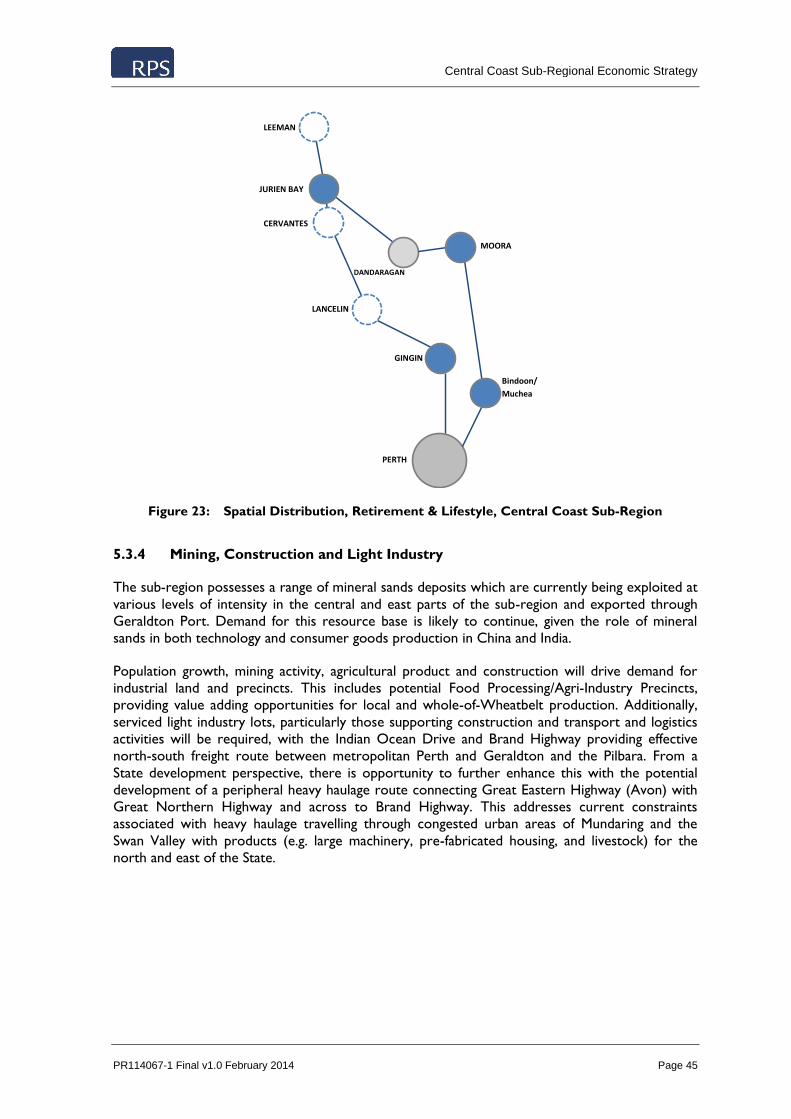
Central Coast Sub-Regional Economic Strategy
PR114067-1 Final v1.0 February 2014 Page 45
Figure 23: Spatial Distribution, Retirement & Lifestyle, Central Coast Sub-Region
5.3.4 Mining, Construction and Light Industry
The sub-region possesses a range of mineral sands deposits which are currently being exploited at
various levels of intensity in the central and east parts of the sub-region and exported through
Geraldton Port. Demand for this resource base is likely to continue, given the role of mineral
sands in both technology and consumer goods production in China and India.
Population growth, mining activity, agricultural product and construction will drive demand for
industrial land and precincts. This includes potential Food Processing/Agri-Industry Precincts,
providing value adding opportunities for local and whole-of-Wheatbelt production. Additionally,
serviced light industry lots, particularly those supporting construction and transport and logistics
activities will be required, with the Indian Ocean Drive and Brand Highway providing effective
north-south freight route between metropolitan Perth and Geraldton and the Pilbara. From a
State development perspective, there is opportunity to further enhance this with the potential
development of a peripheral heavy haulage route connecting Great Eastern Highway (Avon) with
Great Northern Highway and across to Brand Highway. This addresses current constraints
associated with heavy haulage travelling through congested urban areas of Mundaring and the
Swan Valley with products (e.g. large machinery, pre-fabricated housing, and livestock) for the
north and east of the State.
LEEMAN
PERTH
JURIEN BAY
CERVANTES
LANCELIN
GINGIN
Bindoon/
Muchea
DANDARAGAN
MOORA

Central Coast Sub-Regional Economic Strategy
PR114067-1 Final v1.0 February 2014 Page 46
Figure 24: Spatial Distribution, Mining & Construction, Central Coast Sub-Region
5.3.5 Tourism
Similar to the Retirement & Lifestyle opportunities, the Central Coast’s tourism offering is split
into coastal and peri-urban markets. The coastal towns currently have strengths in informal
domestic overnight tourism activity in the form of second and holiday homes. The formalisation of
this activity, through increased provision of hotel, resort and service chalet accommodation is
essential to enhance the local economic contribution of this market segment.
The peri-urban local governments of Gingin and Chittering have established day-trip tourism roles
and perform well compared to other peri-urban locations adjacent to metropolitan Perth. The
historical nature of these towns and agri-tourism opportunities of the area is likely to underpin
tourism activity growth in the future.
The Indian Ocean Drive has the potential to formalise the sub-region’s attractiveness to “Grey
Nomad” travellers, so long as a coordinated branding and marketing efforts are undertaken and a
suite of quality experiential tourism activity is provided to the market. The capacity of major
destinations on the drive to accommodate recreational vehicles with quality facilities will support
the uptake of this activity by the market.
LEEMAN
PERTH
JURIEN BAY
CERVANTES
LANCELIN
GINGIN
Bindoon/
Muchea
DANDARAGAN
MOORA

Central Coast Sub-Regional Economic Strategy
PR114067-1 Final v1.0 February 2014 Page 47
Figure 25: Spatial Distribution, Tourism, Central Coast Sub-Region
Tourism
LEEMAN
PERTH
JURIEN BAY
CERVANTES
LANCELIN
GINGIN
Bindoon/
Muchea
DANDARAGAN
MOORA

Central Coast Sub-Regional Economic Strategy
PR114067-1 Final v1.0 February 2014 Page 48
6.0 ECONOMIC DEVELOPMENT ACTIONS
RPS, in collaboration with the WDC, has compiled a list of actions and initiatives required to
facilitate, support and underpin the realisation of key economic opportunities for the Central
Coast identified in section 4.0 of this Strategy. These Actions have been identified through
consultation with Local Government, and refined within the Spatial Distribution Framework
outlined in section 5.3.
The Actions identified represent a short-list of initiatives for which business cases should be
prepared for funding applications. This includes both State and Federal Government funding
opportunities as well as potential private sector investment.
Further details on the individual Actions are contained in the Local Government Area Profiles,
included in Appendix A of this Strategy.
Note that the identified Actions have been categorized under individual Economic Opportunities.
However, it is acknowledged that some Actions will have enabling and supporting effects for a
range of opportunities and for the Central Coast economy generally.

Central Coast Sub-Regional Economic Strategy
PR114067-1 Final v1.0 February 2014 Page 49
Table 5: Economic Development Actions, Central Coast Sub-Region
LOCAL GOVERNMENT
AREA
AQUACULTURE, HORTICULTURE & FOOD
PROCESSING
RENEWABLE ENERGY RETIREMENT & LIFESTYLE MINING & CONSTRUCTION TOURISM OTHER
Chittering
The Shire of Chittering, Water Corporation and Department of Water to develop water
infrastructure investment plans. Continue to support and facilitate private and public sector investment in
renewable energy production and supporting infrastructure, particularly wind power.
Leverage this investment to build the
sub-region’s national and international profile and “green” credentials.
Establish a sustainable water supply to support future development
Upgrade of the Bindoon main street to create a central and compact space to act as a ‘town centre’.
Construction of the Shire of Chittering multi-purpose Medical Centre in Bindoon to accommodate
a range of health services for the Shire into a single area.
Planning of a Civic Precinct in
Lower Chittering
Develop light industrial lots in Bindoon to address current lack of supply. The development of these
lots will address a number of
current land use conflicts arising from light industrial activity
occurring in residential areas. Continue to support of
development at the Muchea Employment Node. Planning has
been completed in conjunction with
the Department of Planning and Western Australian Planning
Commission to produce the
Chittering-Muchea Employment Node Structure Plan which outlines
short, medium and long term staged developments which require funding
plans to develop the site. Construction of a bypass road in
Bindoon to redirect Great Northern Highway heavy haulage traffic and alignment with the Perth-Darwin Highway upgrades.
Development of a Local Tourism
and Events Strategy
Coorow
Encourage the residential infill of the vacant residential land developed by LandCorp that is
available in Leeman and Green Head.
Continue to liaise with the Shire of Carnamah to annex the existing Shire boundary further north of the Leeman town site.
Increase the number of aged care units in Coorow.
Investigate the expansion of the light industrial area in Coorow.
Construction of a boat ramp facility and improved parking and public
amenities in Leeman to facilitate growth in tourism and recreation activity.
Create a commercial precinct in Leeman as current commercial
properties are ad hoc though out the town (consolidation of zoning in the town centre is required)
Dandaragan Refer to Jurien Bay SuperTown Growth Plan
Gingin
Development of a plan for staged
public utility infrastructure upgrades mirroring projected population increases and horticultural production.
Increase awareness of the ‘food bowl’ branding for the Shire of Gingin in order to increase
investment in horticulture and
intensive agriculture ventures and associated ancillary processing facilities.
Construction of a boat ramp in
Ledge Point to facilitate greater recreational and tourist use.
Development of a diversity of accommodation options to capture
an increased share of overnight visitors vacationing along the coast.
Development of ‘luxury camping’
accommodation to increase overnight visitation
A collaborative approach towards
the promotion of tourist attractions in the Shire and neighbouring LGAs,
which are currently only operating
on a small scale and using ad-hoc promotional strategies.

Central Coast Sub-Regional Economic Strategy
PR114067-1 Final v1.0 February 2014 Page 50
LOCAL
GOVERNMENT AREA
AQUACULTURE,
HORTICULTURE & FOOD PROCESSING
RENEWABLE ENERGY RETIREMENT & LIFESTYLE MINING & CONSTRUCTION TOURISM OTHER
Moora
Completion of water capability assessment in terms of aquifers in
the Shire/region that could facilitate
the expansion of intensive
horticulture initiatives Investigate the possibilities in the
development the food processing
activities in Moora, linking in with the existing intensive horticulture industry occurring surrounding area.
Development of the West End land owned by the Shire of Moora into a rural / residential precinct outside of the flood zone within the main
part of Moora. Facilitate confirmation of investment
from State Government for infill
development. Development of aged care housing
to address local and sub-regional demand for high and low care residential.
Expansion of residential land in the Moora town site out of the flood zone.
Bypass - ring road to the east of
the Moora town site to act as a heavy traffic diversion and flood levy
Expansion of industrial land to the north, south and south east of the
Moora town site out of the flood zone.
Potential for occasional utilisation of water as a result of de-watering from Silicon mine operation
between Moora and Coomberdale Continued enhancement of the
Great Northern Highway.
Development of Administration
Community/Cultural and Visitors Precinct in Moora.
Acquisition and development of the Moora Airfield into a regional
emergency service asset and recreational aviation hub away from the Pearce airspace.

Central Coast Sub-Regional Economic Strategy
PR114067-1 Final v1.0 February 2014 Page 51
APPENDIX A – LOCAL GOVERNMENT PROFILES
Shire of Chittering
Context
The Shire of Chittering covers an area of approximately 1,220 km2 and has a population of 4,509
people (28% of the Central Coast population). The Shire contains the towns and localities of
Bindoon, Lower Chittering, Mooliabeenee, Muchea and Wannamal. The administrative centre of
the Shire is the town of Bindoon, which is located approximately 90 km north of Perth.
Historically, agriculture has been the primary land use within the Shire of Chittering.
The Shire of Chittering sees its advantage in the sub-region as its proximity to Perth and the
provision of rural residential lifestyle lots for those seeking a ‘tree change’. The Shire of
Chittering’s success with residential developments has stemmed from new residents being able to
have the ‘best of both worlds’ where the rural lifestyle of the area is contrasted with the
availability of high quality goods and services close by in Perth.
Long term growth potential of the Shire of Chittering is recognised through renewed focus on the
New Town future urban area and the Muchea Employment Node contained in the newly released
Draft Local Planning Strategy. New Town will allow the Shire to provide housing choice to the
future workforce in the nearby Muchea Employment Node and cater for spill over growth from
Perth. New Town could provide around 16,000 lots accommodating over 41,000 residents when
fully developed without losing its rural ambience. The Shire views the Muchea employment node
currently in development as a significant contributor towards the local economy. The proposed
Muchea employment node is located along major transport routes, and is currently being
developed for service-based uses such as transport, livestock, fabrication, and warehousing,
wholesaling and general commercial use64. A further large scale industrial lot subdivision is
planned to increase the development of light industry within the Muchea employment node.
Characteristics
The Shire of Chittering LGA has the following characteristics:
An estimated residential population of 4,509 persons in 2011 – 53.6% higher than the
estimated 2,936 residents in 2001. The WA Planning Commission forecasts this trend to
accelerate over the next decade, growing a further 53.2% to 6,900 people in 2021. This is
substantially greater than the predicted growth for the State as a whole for the same
period.
A significant proportion of the population (22%) is aged 14 years or younger – greater
than the Perth Metropolitan Region (18.6%) and the WA (19.7%) average. However,
12.9% of Chittering’s population is aged over 65 years, which is not dissimilar than that of
the WA average (12.3%). Chittering had a fertility rate of 2.3 children in 2010 – above
replacement levels (2.1) but below the sub-regional average (2.53). The higher
proportion of people in the younger age profiles may be attributed to the proximity of
Chittering to the metropolitan area and therefore increased accessibility to secondary
education and recreational activities without having to migrate (i.e to boarding school)
out of the area.
64 WAPC, 2011, Muchea Employment Node Structure Plan

Central Coast Sub-Regional Economic Strategy
PR114067-1 Final v1.0 February 2014 Page 52
Median personal income levels for Chittering ($40,364) are significantly greater than the
sub-regional average ($35,347), and above the Perth ($34,788) and WA ($34,424)
averages.
Median house price growth (% 2006 to 2011) for the Shire of Chittering was 33% over
the 5 year period. Although there was considerable variation in the sub-region, this
growth was significantly higher than the sub-regional average (5%). When income levels
are compared with median house prices, the Shire of Chittering’s local housing market is
unaffordable, with a median multiple of 7.1 (unaffordable 5.1, WA average 5.98).
Agriculture is the Shire of Chittering’s primary economic contributor, accounting for
33.6% of businesses and some 71,690.5 ha of land. This accounts, however, for only 6.0%
of the total area of agricultural land holdings in the sub-region and the share of
agricultural businesses is significantly lower than other LGA’s in the Central Coast.
Manufacturing, Transport and Logistics, along with Retail, are secondary industries in the
Shire of Chittering with each accounting for 10.1% and 2.8% of local businesses
respectively.
Chittering’s economy is also underpinned by an employment self-sufficiency rate of 64%
(in 2011). This, coupled with a low unemployment rate of 1.3% indicates that there are
fewer jobs in the LGA than employed persons, highlighting a drive-in/drive-out
interconnectedness with neighbouring coastal communities and Perth.
The Shire of Chittering has one public primary school (208 students) in Bindoon, a private
primary school in Lower Chittering and a Catholic agricultural college (149 students)
north of Bindoon.
Economic Opportunities
The following economic opportunities have been identified:
Aquaculture, Horticulture and Food Processing
Food related industries make up a large proportion of the Shire of Chittering’s local economy and
as such is likely to remain one of the primary economic drivers. For the Shire of Chittering,
horticulture is an already established industry, however there is potential for significant expansion
of production and food processing given its current agricultural production levels, proximity to
the large food producer of Gingin, domestic markets and export terminals. The major barrier to
this development is the lack of security of water supply and capacity of current reticulated potable
water infrastructure. This issue affects not only the expansion of heavy water use industries but
also the development of smaller residential lots. The latter has resulted in many new rural
residential lots not being connected to reticulated potable water services. While this is allowable
due to the zoning of these rural residential lots, they are often unnecessarily larger in size and
inefficient for local government servicing. Additional to this issue is the stipulation of water
traders, whom currently operate in a tripartite water trade with the Water Corporation,
Department of Water and the Shire of Chittering. Access to water needs to be addressed as
water allocations are held by private stakeholders.
The Western Australian Meat Industry Authority (WAMIA) sale yards relocated to Muchea in
2011. The proximity to the major northern transport corridors (Great Northern Highway and
Brand Highway) allows livestock from the northern agricultural and pastoral regions to be sold at
this facility. It also supports the surrounding Wheatbelt and Mid West towns that do not access
the other major sale yards in the south west of the State. There are also a number of cattle feed
lots in the Lower Chittering area. The scale and scope of these operations are currently limited
by global cattle price fluctuations and trade relations and are usually operated to supplement
other farm operations such as intensive horticulture.

Central Coast Sub-Regional Economic Strategy
PR114067-1 Final v1.0 February 2014 Page 53
Retirement and Lifestyle
The Shire of Chittering fits into the lifestyle category of a ‘peri-urban’ settlement and is attracting
permanent residents seeking a high amenity rural but highly accessible residential area. As such,
there are opportunities for residential development to include retiree lifestyle villages given the
existing age profile, prevalence of a number of large residential establishments and the close
proximity to Perth for specialist health services. There are currently 16 residential estates in the
town of Bindoon and Lower Chittering, with a number of these subdivisions still being developed
and others in the intermediate to advanced land release stages. One such residential estate is the
Maryville Estate in Lower Chittering, which consists of 2 hectare lots and is underway with stage
11 and 12 land releases. This estate is one of the more expensive estates in the Shire with lot
prices starting at $265,000. Water connection is often a costly exercise in this area for residential
land development for any densities higher than rural residential zoning.
In order to provide a more diverse housing market, the Shire of Chittering Council is undertaking
a residential development for the elderly, with plans to construct an 80 unit ‘retiree precinct’. The
units are planned for independent aged living, with a medical centre included. With an aging
population in the area creating demand for nursing care level services, there is opportunity for
private development of low and high aged care residential facilities. Chittering residents have
access to a recently upgraded Silver Chain service located in Bindoon which offers nursing
services as well as home care and respite facilities,
Mining, Construction and Light Industry
The planned development of industrial subdivisions at the Muchea Employment Node combined
with the location of Muchea at the intersection of Brand Highway and Great Northern Highway
affords the node the opportunity to establish a highly accessible industrial park to service multi-
sectors including agriculture and mining. Detailed staging plans and infrastructure requirements
can be found in the Muchea Employment Node Structure Plan65.
The emerging industries in the area include transport companies (often supporting the livestock
industry) as well as earth moving and small scale construction (e.g. sheds and transportable
buildings). With the rising cost of industrial land in the metropolitan area, Muchea presents a
great option for these operations. To facilitate further investment at the Muchea employment
node, improved utility services to the industrial land is required.
The Tronox run Chandala Mineral Sands processing plant is located in Muchea. This is a
processing plant for the Cooljarloo Mineral Sands mine located in Cataby. The plant located in the
area again due to the proximity to Perth ports as the majority of the product is exported
overseas. The extractive industry is also well developed with several quarries in operation in the
shire as mentioned in the strategy.
Tourism
The Shire of Chittering has potential to expand its tourism sector, which currently consists
predominately of day trips to the area. To capitalise on this day trip tourism market, a focus on
further development of events and attractions could enhance tourists’ experience. There is also
the potential identified for increased tourist activities based around fresh food and capitalising on
the horticulture and viticulture in the area and linked with operations in neighbouring Gingin and
Moora LGAs (e.g. wine and olive drives/tours). There is a maturing bed and breakfast and farm
65 Available at; http://www.planning.wa.gov.au/publications/6684.asp

Central Coast Sub-Regional Economic Strategy
PR114067-1 Final v1.0 February 2014 Page 54
stay style accommodation market in the Shire of Chittering, however, there is still a need for
further diversity in accommodation options.
Actions
A series of actions require implementation for the Shire of Chittering LGA to effectively leverage
the economic opportunities identified above. The actions listed below are related to increasing
the Shire of Chittering’s attractiveness to permanent residents and attracting commercial and
industrial businesses.
The Shire of Chittering, Water Corporation and Department of Water to develop water
infrastructure investment plans.
Establish a sustainable water supply to support future development
Develop light industrial lots in Bindoon to address current lack of supply. The
development of these lots will address a number of current land use conflicts arising from
light industrial activity occurring in residential areas.
Continued support of development at the Muchea Employment Node. Planning has been
completed in conjunction with the Department of Planning and Western Australian
Planning Commission to produce the Chittering-Muchea Employment Node Structure
Plan which outlines short, medium and long term staged developments requiring funding
plans to develop the site.
Upgrade of the Bindoon main street to create a central and compact space to act as a
‘town centre’.
Construction of a bypass road in Bindoon to redirect Great Northern Highway heavy
haulage traffic and alignment with the Perth-Darwin Highway upgrades.
Construction of the Shire of Chittering multi-purpose Medical Centre in Bindoon to
accommodate a range of health services for the Shire into a single area.
Development of a Local Tourism and Events Strategy
Planning of a Civic Precinct in Lower Chittering

Central Coast Sub-Regional Economic Strategy
PR114067-1 Final v1.0 February 2014 Page 55
Shire of Coorow
Context
The Shire of Coorow covers an area of approximately 4193.9 km² and has a population of 1,091
people (7% of the Central Coast population). The Shire contains the towns and localities of
Coorow, Green Head, Gunyidi, Leeman, Marchagee, Waddy Forest and Warradarge. The
administrative centre of the Shire is the town of Coorow, which is located approximately 270 km
north of Perth. The Shire also has an administration building in the coastal town of Leeman.
Three major towns of Coorow, Leeman and Green Head, support the majority of the Shire’s
economic activity. Each of the distinct towns have a natural environment offering opportunities
suited to the development of different economic drivers. Coorow is primarily a farming town and
is largely focused on broad acre agricultural production. Although Leeman has been closely linked
with mining in the past, it now relies on crayfishing and deep sea fishing as its primary industries.
In Green Head, tourism and retirement based in-migration provides much of the town’s
economic stimulation, with its beaches and relaxed atmosphere.
The Shire of Coorow’s vision for the future is to improve existing facilities in all three towns,
establish aged care accommodation in Coorow and Leeman, and also to expand the towns of
Green Head and Leeman.
Characteristics
The Shire of Coorow LGA has the following characteristics:
An estimated residential population of 1,091 persons in 2011 – a 20.6% decrease in
population relative to the estimated 1,375 residents in 2001. The WA Planning
Commission forecasts this trend to accelerate over the next decade, declining a further
34.9% to 710 people in 2021.
17.3% of the population is aged 14 years or younger – lower than the Perth Metropolitan
Region (18.6%) and the WA (19.7%) average. 19.4% of Coorow’s population is aged over
65 years, which is significantly greater than that of the WA average (12.3%). Coorow had
a fertility rate of 2.65 children in 2010 – above replacement levels (2.1) and the sub-
regional average (2.53).
Median personal income levels for the Shire of Coorow ($36,400) are above the sub-
regional average ($35,347), and above the Perth ($34788) and WA ($34,424) averages.
The Shire of Coorow has a low level of occupation of its housing stock, with 52%
dwellings within the Shire unoccupied at the time of Census collection. This is largely
related to second home owners, holiday homes and seasonal workforce.
Median house price growth (% 2006 to 2011) levels for the Shire of Coorow were low,
with an increase of 2% over the 5 year period. Although there was considerable variation
in the sub-region, this growth was below the sub-regional average. Coorow experienced
significant increases in income levels, though when combined with median house prices,
this still resulted in an unaffordable local housing market (Median multiple of 7, WA
average of 5.98)
Broadacre Agriculture is Coorow’s primary economic contributor, accounting for 55.9%
of businesses and some 323416 ha of land (representing 26.9% of the Central Coasts’
total area of agricultural holdings).
Manufacturing, Transport and Logistics, along with Retail, are secondary industries in
Coorow with each accounting for 8.8% and 5.3% of local businesses respectively.
Coorow’s economy is also underlined by an employment self-sufficiency rate of 70.9% (in
2011). This combined with an unemployment rate of 2.1% indicates that there are fewer

Central Coast Sub-Regional Economic Strategy
PR114067-1 Final v1.0 February 2014 Page 56
jobs in the local government area than there are employed persons highlighting a drive-in-
drive-out interconnectedness with neighbouring coastal communities, Geraldton, and
Perth.
Economic Opportunities
The following economic opportunities have been identified:
Aquaculture, Horticulture and Food Processing
The Shire of Coorow has two main economic drivers due to its coastal and inland environments;
broadacre agriculture and fishing. Coorow is a broadacre farming community, relying on cropping
and livestock. The businesses located in the town itself are heavily reliant and related to the
agriculture industry and are therefore volatile to economic fluctuations related to poor seasons.
The towns of Leeman and Green Head are driven by the crayfishing industry. The restructuring of
the crayfishing industry, through catch and season limitations, has impacted the strength of this
industry and associated ancillary operations.
The availability of more industrial land in Coorow would allow for industry growth, however, the
Shire is currently challenged by the cost of head works for utilities. There are no identified
significant barriers to gradual industrial development appropriate to Leeman and Green Head.
Crayfishing and broadacre agriculture will remain major industries in these towns, however, they
are both export based industries so will remain volatile to the world market, value of the
Australian dollar, and global demand.
Renewable Energy
The Shire of Coorow is well positioned for wind power generation due to its coastal proximity
and also the ability to connect to the upgraded infrastructure associated with Mid West Energy
project. An example of the Shire’s capacity for renewable energy production is the Warradarge
Wind Farm, a Verve energy project that will be operating on a site situated in both the Shire of
Coorow and the Shire of Carnamah. Once operational the project will run up to 100 wind
turbines.
Retirement and Lifestyle
The towns of Leeman and Green Head offer an attractive lifestyle for retirees who are able to live
independently, and as such, the town of Green Head has a growing retiree population. Both
Leeman and Green Head have residential land (Landcorp) development ready. There is access to
health services from the Silver Chain nurse in Leeman and higher level care available nearby in
Jurien Bay. The town of Coorow relies on health services in Moora. There is a gap in general
health and aged services in the Shire of Coorow which has resulted in a reliance on surrounding
towns.
Water and power supplies are sufficient for slow growth in residential land in Leeman and Green
Head however the current supplies would not support large, rapid growth due to the age and
capacity of the infrastructure. Currently the local government boundary is too close to the town
of Leeman for further development to the north. Negotiations are taking place between the Shire
of Carnamah and Shire of Coorow in relation to extending the Shire of Coorow boundary further
north.

Central Coast Sub-Regional Economic Strategy
PR114067-1 Final v1.0 February 2014 Page 57
Tourism
The opening of the Indian Ocean Drive has increased tourism to the coastal towns in the Shire of
Coorow. The town of Leeman is one of the few towns that is located directly on the drive which
has the potential to be a major benefit to businesses. There is also an on flow of visitors who are
coming from the Pinnacles, Cervantes. Leeman and Green Head attract a large amount of
domestic holiday makers who own or rent a house in the summer months. The town of Leeman
currently has two boat ramps, with a third to be constructed by April 2014 in order to sufficiently
provide for recreational fisherman and boaters. There is a general need for improved
accommodation and food services on the coast to attract tourists to the towns.
Tourists are attracted inland towards Coorow in the wildflower season with potential for
increased eco-tourism activities in the State and National Parks in the area. Tourist information
for both the coast and inland is coordinated by the Shire.
Mining, Construction and Light Industry
The mineral sands mine located in Eneabba has been a significant site for mineral sand production
since the 1970’s. The town of Leeman has had a long association with the mine as many residents
of the town have been employed there. In recent years however, the mine has reduced
productivity and has announced that it will be operating in ‘idle’ as of April 2013 due to lack of
demand for production in 2012. This has had a negative impact on the town as residents who
were engaged at the mine have moved elsewhere for employment which has subsequently
impacted local businesses with reduced demand for their services. There has been exploration for
other resources in the area, however to-date no major operations have began as a result.
Currently light industrial land in the Shire is occupied by a range of businesses, however mostly
on a small or personal scale. The Shire has investigated the potential for more serviced light
industrial land to be developed in the town of Coorow though the cost of head works is an
impediment to this development occurring. The availability of serviced light industrial land in
Greenhead and Leeman is currently adequate.
Actions
A series of actions require implementation for the Shire of Coorow LGA to effectively leverage
the economic opportunities identified above. The actions listed below are related to increasing
Coorow’s attractiveness to new permanent residents and retirees, commercial/ light industrial
businesses and tourists:
Encourage the residential infill of the vacant residential land developed by LandCorp that
is available in Leeman and Green Head.
Create a commercial precinct in Leeman as current commercial properties are ad hoc
thoughout the town (consolidation of zoning in the town centre is required)
Increase the number of aged care units in Coorow.
Investigate the expansion of the light industrial area in Coorow.
Shire of Coorow to construct quality housing in Coorow for Shire staff.
Construction of a boat ramp facility and improved parking and public amenities in Leeman
to facilitate growth in tourism and recreation activity.
Continue to liaise with the Shire of Carnamah to annex the existing Shire boundary
further north of the Leeman town site.

Central Coast Sub-Regional Economic Strategy
PR114067-1 Final v1.0 February 2014 Page 58
Shire of Dandaragan
Context
The Shire of Dandaragan covers an area of approximately 6716 km² and has a population of 3,277
people (20% of the Central Coast population). The Shire contains the towns and localities of
Jurien Bay, Dandaragan, Cervantes and Badgingarra. The administrative centre of the Shire is the
town of Jurien Bay, which is located approximately 220 km north of Perth.
The development of the towns within the Shire has been historically based upon both fishing and
broadacre agriculture. The complementing seasonality of the farming and fishing seasons allowed
for both of these industries to develop together, and to provide work for residents year round.
While these two activities still act as the backbone of the local economy, a restructuring of the
fishing industry has seen a reduction in fishing due to reduced catchment allowances, tightened
regulations and lower supply of fishing licences.
The Shire of Dandaragan sees its future in developing its tourism industry, in order to further
capitalise on the Shire’s current recreational development, coastal location and natural amenity.
The Shire is also seeking to further expand its fishing industry, with an increase in the amount of
processing of locally caught rock lobster. Jurien Bay seeks to develop a greater residential
population through improving community services, and through the introduction of retiree
lifestyle units and aged care facilities.
Characteristics
The Shire of Dandaragan LGA has the following characteristics:
An estimated residential population of 3,277 persons in 2011 – 11.5% higher than the
estimated 2,940 residents in 2001. The WA Planning Commission forecasts this trend to
continue over the next decade, growing to 4,000 people in 2021.
A significant proportion of the population (19.1%) is aged 14 years or younger – not
dissimilar to the Perth Metropolitan Region (18.6%) and the WA (19.7%) averages.
However, 17.5% of Dandaragan’s population is aged over 65 years, which is significantly
greater than that of the WA average (12.3%). Dandaragan had a fertility rate of 2.26
children in 2010 – marginally above replacement levels (2.1) but below the sub-regional
average (2.53).
The Shire of Dandaragan has a low level of occupation of its housing stock, with 44% of
the Shire’s dwellings unoccupied at the time of Census collection. This is largely related to
second home owners, holiday homes and seasonal workforce.
Median personal income levels for Shire of Dandaragan ($33,874) are below the sub-
regional average ($35,347), and below the Perth ($34,788) and WA ($34,424) averages.
Median house price growth (% 2006 to 2011) levels for the Shire of Dandaragan were
10% over the 5 year period. Although there was considerable variation in the sub-region,
this growth was significantly above the sub-regional average (5%). When income levels are
compared with median house prices, the Shire was found to be the least affordable
housing market in the sub-region (median multiple of 8.1, Sub-regional average 6.4, WA
average 5.98).
Agriculture is Dandaragan’s primary economic contributor, accounting for 48.2% of
businesses and some 384,601 ha of land (representing 32.03% of the Central Coasts’ total
area of agricultural holdings).
Manufacturing, Transport and Logistics, along with Retail, are secondary industries in
Shire of Dandaragan, with each accounting for 6.2% and 4.1% of local businesses
respectively.

Central Coast Sub-Regional Economic Strategy
PR114067-1 Final v1.0 February 2014 Page 59
Shire of Dandaragan’s economy is also underlined by an employment self sufficiency rate
of 90.9% (in 2011). This, coupled with a low unemployment rate of 1.20%, indicates that
the majority of residents reside and work within the Shire.
The Shire has a District High School in Jurien Bay (320 students) and primary schools in
each of the other three communities (Cervantes, Badgingarra and Dandaragan).
Economic Opportunities
The following economic opportunities have been identified:
Aquaculture, Horticulture and Food Processing
The Shire of Dandaragan has a strong association to food production through the agricultural,
horticultural and fishing industries. The town of Dandaragan supports a strong farming
community. The area has traditionally been associated with broad acre cropping and livestock
production however in recent times there has been some diversification into intensive
horticulture. There are several citrus orchards located within the Shire of Dandaragan as well as
stone fruits and some vegetable production. This growth has been driven largely by the availability
of underground water. The growth of intensive horticulture is expected to continue with the
current producers planning to expand their operations from just growing to processing and
packaging. The current market has a domestic focus (e.g. Western Australia has the second
highest market price for Navel oranges in Australia), however there is potential for the products
to be exported. Entering international markets is currently challenged by the high Australian
Dollar. Intensive horticulture is becoming a significant employer in the area and the job
opportunities are expected to grow as the operations increase.
The Western Rock Lobster industry has played a significant part in shaping the local economy and
its population structure. In addition to direct employment, the industry contributes to
employment in ancillary activities, including processing, transport, boat-building and repair, and
public services. As mentioned earlier in this document, the industry is undergoing significant
restructuring with policy changes and technological advances. The industry as a whole remains
profitable, however individual operators have experienced an ongoing cost-price squeeze. These
trends extend to the Shire of Dandaragan where the fishery still has an important place but its
role as a major employer is diminishing.
The potential to develop a considerable aquaculture industry in the area has been identified by the
coastal local governments, regional bodies and investors both national and international. There
are few places in the southern hemisphere where sea cage farming of firm white fleshed finfish is
undertaken in temperate waters, yet global demand for edible sea foods from aquaculture and
mariculture is increasing. The Central Coast sub-region, and the coastline of the Shire of
Dandaragan in particular, has a natural competitive advantage for marine farming and sea cage
management in terms of water flow, water temperature, water quality, established commercial
fishing industry and access to markets. Furthermore, planning documents for the Department of
Fisheries and the Shire of Dandaragan have identified suitable sites and species for both land and
sea based aquaculture operations.
While operations are currently stalled, the potential to cultivate a variety of species of fish and
crustaceans in the area remains and is backed by considerable research. Developing an
aquaculture industry also has the opportunity for the establishment of associated ancillary
industries, particularly grains and processing units for the production of fishfeed alternatives.
Although the Shire of Dandaragan does not currently conduct any aquaculture or large scale food
processing (beyond crayfish) the town is well positioned to take advantage of its ability to expand
its local economy into these new industries. While food processing is not a new industry in the

Central Coast Sub-Regional Economic Strategy
PR114067-1 Final v1.0 February 2014 Page 60
area, there is limited processing currently being undertaken, with a favouring of trucking out
unprocessed produce to Perth along the Indian Ocean Drive and Brand Highway. While this
practice has become ingrained into the industry, there is significant scope to develop food
processing businesses in the area which will not only provide a value-add to the town’s current
industry, but reduce trucking volumes of produce, thus providing a more ecologically sustainable
product.
Renewable Energy
Several areas within the Shire of Dandaragan have been identified to have great potential for
renewable energy production, particularly wind and solar generation. There are already several
renewable energy projects underway in the Shire of Dandaragan including the Emu Downs Wind
farm as well as the first WA utility scale solar photovoltaic farm developed inland of Cervantes.
Further development and investment in renewable energy will require significant upgrades in the
transmission and distribution infrastructure
Retirement and Lifestyle
Population on the coast is expected to grow due to the natural amenity, and proximity to Perth.
Jurien Bay and Cervantes offer an attractive retiree destination, and already have a significant
number of Western Australian retirees making the sea change to the area. The Shire of
Dandaragan has prioritised improving Aged Care and Health facilities in Jurien Bay to service the
town and surrounding areas. This plan includes a residential Aged Care facility and an integrated
Health plan which includes expansion and renovation of the Medical Centre and the construction
of a Wellness/ Community Health Centre. Once completed, these services will facilitate the
growth of the retiree population and greater retention of the aged population. This approach will
complement the aged friendly and/or independent living accommodation options in the recently
released RSL development in Jurien Bay.
Mining, Construction and Light Industry
There is potential for increased mining and mining support activity in the Shire of Dandaragan.
There is a mineral sands mine currently in operation in Cataby, which employs up to 300 people
who live locally or work on a drive–in/drive-out arrangement. There is scope to expand mineral
sand mining however the viability of extraction is often determined by global prices and demand.
Oil and gas deposits have been identified on and off shore, but again the commencement of mining
works is dependent on global market conditions and the viability of the scale of deposits available
for processing.
The construction industry in this area will continue to be driven by residential and industrial
growth on the coast. Construction has the potential to be a large employer for the towns
experiencing this growth; however it is dependent of the attraction and retention of local
workforce skills and enterprise to provide the trades, equipment and materials to develop houses,
commercial buildings and infrastructure.
Tourism
The significance of tourism in the economies of the coastal towns in the Shire of Dandaragan is
forecast to increase with the improved awareness and accessibility to the area with the opening of
the Indian Ocean Drive.
The Pinnacles, located 17kms from Cervantes, is an international tourist destination, visited by
over 200,000 people annually. Visitor numbers remain consistent despite a decline experienced in
many other domestic destinations. The Pinnacles does not underpin a strong overnight visitation

Central Coast Sub-Regional Economic Strategy
PR114067-1 Final v1.0 February 2014 Page 61
to the region as tour companies offer day trip services. The Lesueur and Stockyard National Park
visitor numbers have been increasing in the past ten years with the Department of Parks and
Wildlife indicating that there are now over 10,000 visitors to each annually. Eco and farm tourism
has been identified as a possible growth area around Badgingarra and Dandaragan town due to the
well-established agricultural industry and wildflower displays. Adventure and nature-based tourism
activity is a significant economic opportunity for the coastal areas of the Shire of Dandaragan (e.g.
skydiving, 4WD, quad bikes, fishing, diving, wind/kite surfing, activities experiencing the national
parks etc).
The Jurien Bay Boat Harbour is a strategic infrastructure asset that is currently underutilised.
There are large areas of undeveloped and underutilised land at the harbour which have significant
potential to create a vibrant commercial, tourist and recreational precinct to contribute to the
development of Jurien Bay as a future regional city. The Department of Transport has continued
to investigate opportunities that could activate sale and/or development of vacant lots at the
marina and stimulate greater use and development of the wider marina precinct. The Master
Planning Report – Jurien Bay Boat Harbour Southern Precinct – May 2012 (subject to public
consultation) examines the development potential of an approximately 6ha area vested with the
Department of Transport. The study recommends staged development of the site. Key elements
of the proposal centre on tourism and mixed use development (e.g. tourist chalet park, retail
small business, markets, food and beverage venues).Tourist and recreation use are the principal
drivers of aviation traffic in Jurien Bay. Skydive Jurien Bay is a significant user of the airport with
71.2% of recorded landings between April 2011 and March 2012 (1,749 counts). There has also
been interest in developing airfield accommodation hangars aimed at meeting the recreation pilot
demand for coastal holiday visitation. As part of forward planning, the Shire of Dandaragan is
investigating a new site for a future expanded airport in Jurien Bay. This master plan will consider
the costs and implications of the relocation of the existing airport and development of a regional
airport based on considerations for the needs of industry, emergency services, recreation and
tourism as Jurien Bay develops.
The increase in day trips, international visitation and adventure tourism activities provides
opportunities for the expansion and diversification of holiday accommodation, hospitality offerings
and retail sector. The area however, does experience seasonal fluctuations and the economic
contribution associated with a high concentration of holiday and second home owners located in
Jurien Bay and Cervantes is often hard to measure.
Actions
A series of actions require implementation for the Shire of Danadragan LGA to effectively
leverage the economic opportunities identified above. There are a large range of projects
highlighted in the Jurien Bay SuperTowns Growth Plan (available from:
www.dandaragan.wa.gov.au). The first two funded through this process relate to developing a
Visitor and Civic Precinct adjacent to the existing Shire offices and developing stage one of an Infill
Sewerage system. The development of the Jurien Bay foreshore area will continue as well as a
focus on attracting investment in the Aged Care and Health project. The continuation of
horticulture precinct planning is a priority for the agricultural area of the Shire. The Shire of
Dandaragan priority projects are consistent with the economic analysis, resulting from extensive
local and regional planning.

Central Coast Sub-Regional Economic Strategy
PR114067-1 Final v1.0 February 2014 Page 62
Shire of Gingin
Context
The Shire of Gingin covers an area of approximately 3,325 km2 and has a population of 4,801
people (30% of the Central Coast population). The Shire contains the towns and localities of
Gingin, Lancelin, Seabird, Ledge point and Guilderton. The administrative centre of the Shire is
the town of Gingin, which is located approximately 84 km north of Perth.
Peri-urban growth and associated pressure on market gardening has resulted in the Shire of
Gingin broadening its focus from a traditional broadacre to intensive horticulture. The area is
recognised for its high productivity, producing fruits, vegetables, eggs and meats for domestic and
overseas markets. Consequently the Shire of Gingin sees itself as the ‘food bowl’ of the
Wheatbelt. The Shire of Gingin also capitalises on its close proximity to Perth, exporting produce
through the metropolitan’s ports.
Characteristics
The Shire of Gingin LGA has the following characteristics:
An estimated residential population of 4,801 persons in 2011 – 12.8% higher than the
estimated 4,257 residents in 2001. The WA Planning Commission forecasts this trend to
continue over the next decade, growing a further 1.2% to 5,400 people in 2021.
A significant proportion of the population (19.6%) is aged 14 years or younger – not
dissimilar to the Perth Metropolitan Region (18.6%) and the WA (19.7%) average.
However, 18.8% of the Shire of Gingin’s population is aged over 65 years, which is
significantly greater than that of the WA average (12.3%). The Shire of Gingin had a
fertility rate of 2.68 children in 2010 – above replacement levels (2.1) and above the sub-
regional average (2.53).
Median personal income levels for the Shire of Gingin ($32,128) are below the sub-
regional average ($35,347), and below the Perth ($34788) and WA ($34,424) averages.
The Shire of Gingin experienced a decrease of 12% in median house prices between 2006
and 2011(compared to a 5% growth in the sub-region for the same 5 year period). House
prices in the Shire of Gingin both on the coast and inland declined significantly during the
GFC and have not made the same recovery as prices in other LGAs. When income levels
are compared with median house prices, the result remains an unaffordable local housing
market (Median multiple of 7.8, WA average 5.98)
The Shire of Gingin has a low level of occupation of its housing stock, with 49% dwellings
within the Shire unoccupied at the time of Census collection in 2011.
Agriculture is the Shire of Gingin’s primary economic contributor, accounting for 41.9% of
businesses and some 137,145 ha of land (representing 11.42% of the Central Coasts’ total
area of agricultural holdings).
Manufacturing, Transport and Logistics, along with Retail, are secondary industries in
Gingin, with each accounting for 8.9% and 3.1% of local businesses respectively. .
The Shire of Gingin’s economy is also underlined by an employment self-sufficiency rate of
83% in 2006 and dropping to 75% in 2011. This, coupled with a low unemployment rate
of 1.6%, indicates that there are more jobs than employed residents in the LGA
highlighting a drive-in/drive-out interconnectedness with neighbouring coastal
communities and Perth.
The Gingin District High School (438 Students) provides important educational services
for local residents.

Central Coast Sub-Regional Economic Strategy
PR114067-1 Final v1.0 February 2014 Page 63
Economic Opportunities
Agriculture, Horticulture and Food Processing
Horticulture is already a very strong driver of the local economy, producing very large volumes of
fresh vegetables, fruits, olives, meat and eggs to Perth, Western Australian and overseas markets.
Below are the highest value products grown in the Shire of Gingin and their contribution to the
WA total gross value;
Olives $7.3 million (61% of total WA value)
Lettuce $8 million (58% of total WA value)
Carrots $19.2 million (43% of total WA value)66
The Shire of Gingin is well placed for horticultural production and first and second order food
processing (particularly for highly perishable products such as lettuce and tomatoes for daily
delivery to Perth) as it is close to major transport corridors to the vegetable markets located in
Perth, quality soil and rainfall and availability of underground water. The ability to access these
water supplies for horticultural use will need to be resolved to secure growth in this sector.
Accessing power is also an issue as the existing infrastructure does not support large increases in
consumption.
Renewable Energy
There are currently several wind turbines in operation to the east of the Lancelin town site. They
are operated by independent participants and feed into the South West Interconnected system.
Similar to other LGAs in the sub-region there are significant opportunities to expand the
renewable energy industry with upgraded distribution infrastructure.
Retirement and Lifestyle
There is a need for the upgrading of utilities in the Shire in order to cater to increased future
resident numbers, with water (Guilderton, Lancelin, Ledge Point, Seabird), power (Ledge Point,
Seabird) and sewerage (Gingin, Guilderton, Ledge Point, Seabird) upgrades required. Native title
issues in Lancelin will need to be resolved to facilitate further retail expansion and the presence of
Crown reserves in Ledge Point and Seabird will restrict significant residential expansion.
There are currently no specific retiree developments in the Shire, though there is demand for
such investments. There is also potential for increased health services catering towards high care
nursing care. As such, there is significant opportunity for the development of the towns within the
Shire of Gingin to develop a competitive advantage for retirement and lifestyle.
Mining, Construction and Light Industry
Availability of land in the Shire of Gingin provides the opportunity for expansion of industrial
activity within the Shire. The location of Gingin on major transportation routes further enhances
the opportunity for the development of affordable industrial sites to service the mining industry
outside of the Perth metropolitan area.
Tourism
66 ABS 2012, Value of Agricultural Commodities produced 2011-2012 (75030), Canberra

Central Coast Sub-Regional Economic Strategy
PR114067-1 Final v1.0 February 2014 Page 64
Natural amenity and proximity to Perth, combined with the development of horticulture in the
area provide the opportunity food based tourism and events in the inland areas. The town of
Gingin’s proximity to Perth makes it an attractive day trip destination and there is potential for
the Gingin Observatory and Gravity Discovery Centre to facilitate growth in the
knowledge/science based tourism sector. The opening up of the Indian Ocean Drive and the
proximity to Perth has lead to increased accessibility to the coastal towns of Ledge Point,
Guilderton and Lancelin that are now popular with domestic holiday makers particularly over the
summer months.
There is potential for development of quality, diversified accommodation however the proximity
to Perth and popularity of day trips could limit the tourists choosing to stay overnight. Lancelin is
a popular water sport destination and home the international windsurfing event the Lancelin
Ocean Classic. There is potential for increased adventure tourism development in this area
however seasonality of tourist numbers and the cost of insurance is a current barrier for
attracting businesses of this kind. The promotion of the area as a tourist destination is currently
done by the Gingin Coast to Country Tourism Association and Tourism WA’s Experience Perth
campaigns.
Actions
A series of actions require implementation for the Shire of Gingin LGA to effectively leverage the
economic opportunities identified above. The actions listed below are related to increasing the
attractiveness to tourists visiting the area, retirees and the elderly, and removing constraints to
population expansion.
Development of a plan for staged public utility infrastructure upgrades mirroring
projected population increases and horticultural production.
Development of a diversity of accommodation options to capture an increased share of
overnight visitors vacationing along the coast.
Development of ‘luxury camping’ accommodation to increase overnight visitation
Increase awareness of the ‘food bowl’ branding for the Shire of Gingin in order to
increase investment in horticulture and intensive agriculture ventures and associated
ancillary processing facilities.
A collaborative approach towards the promotion of tourist attractions in the Shire and
neighbouring LGAs, which are currently only operating on a small scale and using ad-hoc
promotional strategies.
Construction of a boat ramp in Ledge Point to facilitate greater recreational and tourist
use.

Central Coast Sub-Regional Economic Strategy
PR114067-1 Final v1.0 February 2014 Page 65
Shire of Moora
Context
The Shire of Moora covers an area of approximately 3767 km² and has a population of 2,550
people (16% of the Central Coast population). The Shire contains the towns of Moora, Miling and
Watheroo, as well as the localities of Bindi Bindi, Coomberdale, Koojan, Walebing and Round
Hill. The administrative centre of the Shire is the town of Moora, which is located approximately
177km north of Perth.
Moora is historically a broadacre farming area and has maintained its reliance on this industry.
Approximately 6000 people within a radius of 100km visit the town regularly to utilise the
services offered in Moora. These services include health, social, education, recreation and
community.
Moora’s vision for the future is to provide a regional service role for its surrounding population of
6000. It has aspirations for its local economy to grow with the advent of fibre to the premises
which will allow for greater information service based businesses to operate in the town.
Characteristics
The Shire of Moora LGA has the following characteristics:
An estimated residential population of 2,550 persons in 2011 – a 5.3% decrease in
population relative to the estimated 2,694 residents in 2001. The WA Planning
Commission forecasts this trend to continue over the next decade, declining a further
5.9% to 2,400 people in 2021.
A significant proportion of the population (22.3%) is aged 14 years or younger – higher
than the Perth Metropolitan Region (18.6%) and the WA (19.7%) average. 12.7% of
Moora’s population is aged over 65 years, which is not dissimilar than that of the WA
average (12.3%). Moora had a fertility rate of 2.74 children in 2010 – above replacement
levels (2.1) and the sub-regional average (2.53).
Median personal income levels for Moora ($33,969) are below the sub-regional average
($35,347), and below the Perth ($34788) and WA ($34,424) averages.
Median house price growth (% 2006 to 2011) levels for the Shire of Moora were 46%
over the 5 year period. Although there was considerable variation in the sub-region, this
growth was very high, and almost 3 times greater than the sub-regional average (16%).
Whilst displaying the largest increase in housing price in the sub-region, Moora remained
the most affordable out of the 5 Shires, with a median multiple of 2.1 (sub-regional
average 6.4, WA average of 5.98), making it a very affordable local housing market.
Agriculture is Moora’s primary economic contributor, accounting for 52.6% of businesses
and some 355,560 ha of land (representing 29.6% of the Central Coasts’ total area of
agricultural holdings).
Manufacturing, Transport and Logistics, along with Retail, are secondary industries in
Moora, with each accounting for 2.9% and 5.9% of local businesses respectively.
Moora’s economy is underlined by an employment self sufficiency rate of 92.3% (in 2011),
indicative of a large proportion of people that live and work within the Moora Shire.
The Moora hospital (22 beds) and the Central Midlands Senior High School (183
students) provide important health and educational services for local and sub-regional
residents.
Indigenous people make up 12.3% of the Shire of Moora’s population, which is a
significantly higher proportion of the population that of Western Australia which has a
3.1% Indigenous population.

Central Coast Sub-Regional Economic Strategy
PR114067-1 Final v1.0 February 2014 Page 66
Economic Opportunities
The following economic opportunities have been identified:
Agriculture, Horticulture and Food Processing
There is a well-established broad acre agriculture and livestock industry in the Shire which is very
well supported in the town of Moora by agricultural related businesses ranging from finance and
accounting to machinery sales. The area is climatically reliable but still volatile to poor seasons and
global price fluctuations.
Intensive horticulture is an emerging industry in the area surrounding Moora and is predicted to
be a significant employer. There are two well established citrus orchards and one stone fruit
orchard located within 30km of the Moora townsite These businesses have been able to
overcome limitations posed by insufficient rainfall levels for this type of production by
supplementing orchards with water from the Leederville-Parmelia Aquifer. There is significant
scope for the intensive horticulture industry to further expand if access to these underground
water supplies is secured. The sustainable use of the aquifers needs to be planned with this in
mind and not solely linked to providing security for Perth metropolitan growth.
Further population attraction strategies could be implemented in Moora to alleviate labour
shortages in the agricultural and supporting sectors.
Renewable Energy
The area surrounding Moora has great potential for the generation of renewable energy,
particularly solar which can be at peak production during the peak usage times. A solar
photovoltaic farm has been proposed by company ‘Energy Made Clean’, which has identified
potential for the installation of a 5 megawatt solar farm which will cover an area of 10 hectares.
The development will see a power generation of 8.76 giga watts hours per annum, equivalent to
the yearly power needs of approximately 1500 homes each year. The construction of the farm has
not yet been confirmed, with infrastructure requirements from Western Power slowing the
development of the project. Wind energy also has potential for development however growth in
this area seems to be occurring more to the west and closer to the coast.
Retirement and Lifestyle
Moora has the opportunity for significant housing development, with a deep sewerage system
allowing for high density, and large areas of land within close proximity to the town for possible
expansion of the urban centre of the Shire. The Moora Multi-Purpose Service provides a wide
range of health services to the Shire of Moora and the larger midlands sub-region. The Shire of
Moora is currently developing a master plan for a lifestyle village aged care facility, with a 30-40
bed capacity and additional health care services. This will allow for local ageing populations to be
retained and potential for increased retiree in-migration.
There is capacity for the development of residential blocks within the Shire, although the costs of
development of the lots are an obstacle to development. Significant head works costs and a lack
of interest in the existing blocks for sale in the town has prevented further development of
residential infill in the Moora town site.

Central Coast Sub-Regional Economic Strategy
PR114067-1 Final v1.0 February 2014 Page 67
Mining, Construction and Light Industry
Currently the major industry within the Shire is agriculture, with recent developments of a rapid
rail loading system for CBH developed in 2012 allowing for increased grain handling capacity.
Large scale projects in the mining sector include the Warro gas project (construction of a gas
pipeline) and expansion of the Simcoa Company’s quartz mining operations. The Simcoa quarry in
Moora has been identified to have a over two million tonnes of quartzite (rock from which silicon
is derived), and over four million tonnes of quartzite in the ‘indicated and inferred resources’67
category. The Simcoa mining company’s operations are therefore anticipated to continue to
provide economic stimulus in the form of local employment in the area in the medium-term
future. There is potential for industrial expansion outside of the agricultural industry, with a
number of serviced industrial lots available, and with an extension of Moora’s industrial park
currently underway. These lots may be of use to businesses seeking to capitalise on spin-off
ventures inspired by the Warro and Simcoa developments.
Actions
A series of actions require implementation for the Shire of Moora to effectively leverage the
economic opportunities identified above. As Moora is considered the regional centre for the
Central Midlands and its economic profile is closely aligned to that sub-region, the priority
projects and actions are listed in both this report and the Central Midlands Sub-Regional
Economic Planning Strategy.
Bypass - ring road to the east of the Moora town site to act a heavy traffic diversion and
flood levy
Expansion of industrial land to the north, south and south east of the Moora town site
out of the flood zone
Potential for occasional utilisation of water as a result of de-watering from Silicon mine
operation between Moora and Coomberdale
Continued enhancement of the Great Northern Highway
Development of Administration Community/Cultural and Visitors Precinct in Moora
Acquisition and development of the Moora Airfield into a regional emergency service
asset and recreational aviation hub away from the Pearce airspace.
Completion of water capability assessment in terms of aquifers in the Shire/region that
could facilitate the expansion of intensive horticulture initiatives
Investigate the possibilities in the development the food processing activities in Moora,
linking in with the existing intensive horticulture industry occurring surrounding area.
Development of the West End land owned by the Shire of Moora into a rural / residential
precinct outside of the flood zone within the main part of Moora.
Facilitate confirmation of investment from State Government for infill development
Development of aged care housing to address local and sub-regional demand for high and
low care residential
Expand and increase the sustainability of childcare in Moora in order to attract and retain
working families
67 Simcoa Company website, accessed 26 March 2013, available from: http://www.simcoa.com.au/company-2.html

Central Coast Sub-Regional Economic Strategy
PR114067-1 Final v1.0 February 2014 Page 68
APPENDIX B – INDUSTRY VALUE ADDED
Table 6: Industry Value Added and Gross Regional Product, Central Coast, 2010/11 to
2012/13
Industry 2010/11 2011/12 2012/13
Agriculture, forestry & fishing $152,908,374 $216,010,001 $120,706,171
Mining $80,597,333 $102,370,837 $107,051,137
Manufacturing $58,705,888 $66,196,068 $66,694,044
Electricity, gas, water & waste services $20,926,399 $23,768,564 $23,083,670
Construction $94,690,980 $116,001,084 $114,453,238
Wholesale trade $28,161,828 $32,107,206 $33,567,455
Retail trade $21,847,617 $24,454,979 $25,832,327
Accommodation & food services $11,561,424 $13,546,431 $13,658,696
Transport, postal & warehousing $39,688,462 $43,078,589 $43,983,164
Information media & telecommunications $3,396,729 $3,459,556 $3,252,469
Financial & insurance services $12,498,701 $13,314,625 $13,503,213
Rental, hiring & real estate services $5,769,772 $6,773,784 $7,375,835
Professional, scientific & technical services $10,885,605 $11,898,199 $12,523,814
Administrative & support services $11,554,312 $11,865,011 $12,847,911
Public administration & safety $26,314,172 $28,305,946 $28,595,895
Education & training $26,177,599 $27,996,573 $28,452,356
Health care & social assistance $13,535,315 $14,656,610 $15,595,142
Arts & recreation services $2,011,164 $2,183,028 $2,199,622
Other services $9,272,713 $10,712,340 $10,215,096
Industry Value Added $630,504,384 $768,699,431 $683,591,255
Ownership of Dwellings $41,793,601 $50,953,996 $45,312,517
Gross Value Added $672,297,986 $819,653,427 $728,903,771
Taxes Less Subsidies $23,801,765 $29,018,677 $25,805,813
Statistical Discrepancy $203,136 $247,659 $220,239
Gross Regional Product $696,302,886 $848,919,763 $754,929,823

Central Coast Sub-Regional Economic Strategy
PR114067-1 Final v1.0 February 2014 Page 69
APPENDIX C – SOCIO-ECONOMIC INDICATORS MATRIX
Attached

Theme Indicator Source Dandaragan Gingin Chittering Moora Coorow Central CoastPopulation (2001) ABS3218.0 (2001) 2940 4257 2936 2694 1375 14202Population (2011) Census 2011 3185 4685 4428 2476 1067 15841Population (2011) ABS3218.0 (2011) 3277 4801 4509 2550 1091 16228Population Growth (No. 2001 to 2011) ABS3218.0 (2011) 337 544 1573 -144 -284 2026Population Growth Rate (% 2001 to 2011) ABS3218.0 (2011) 11.46% 12.78% 53.58% -5.35% -20.65% 14.00%Compound Annual Growth Rate (% 2001 to 2011) ABS3218.0 (2011) 1.10% 1.20% 4.40% -0.50% -2.30% 1.30%Projected Population (2021) WAPC (Medium) 4000 5400 6909 2400 710 19710Population Growth (No. 2011-2021) calc 723 599 2400 -150 -381 3482Population Growth Rate (% 2011 to 2021) calc 22.06% 12.48% 53.23% -5.88% -34.92% 21.46%Annual Population Growth Rate (% 2011-2021) calc 2.01% 1.18% 4.36% -0.60% -4.20% 1.96%Share of Population Aged 0-14 (% 2010) ABS3235.0 21% 19% 22% 20% 18% 20%Share of Population Aged 0-14 (% 2011) Census 2011 19% 20% 22% 22% 17% 20%Share of Population Aged 65+ (% 2010) ABS3235.0 17% 17% 12% 13% 19% 14%Share of Population Aged 65+ (% 2011) Census 2011 18% 19% 13% 13% 19% 16%Male Share of Population (% 2010) ABS3235.0 53% 52% 52% 53% 57% 53%Fertility Rate (2010) ABS3301.0 2.26 2.68 2.33 2.74 2.65 2.53Baby Bonus Receipient (2010) ABS National Regional Profile 28 48 31 36 12 155Average Individual Wage and Salary Income (2006) ABS5673 $32,084 $34,041 $38,129 $31,583 $35,668Average Individual Wage and Salary Income (2009) ABS5673 $41,326 $40,850 $47,783 $38,486 $45,205Median Personal Income (weekly) Census 2011 $29,796 $24,544 $29,380 $30,680 $25,636Median Individual Wage and Salary Income (2009) ABS5673 $33,874 $32,128 $40,364 $33,969 $36,400Median Individual Income (2009) ABS6524.0.55.003 $33,874 $32,128 $44,458 $33,969 $36,400SEIFA Score ABS Census (2006) 957 942 983 943 955Number of Newstart Allowance Receipients (2010) ABS National Regional Profile 72 83 68 73 35 331Total Dwelling Stock ABS Census (2011) 2577 3457 1827 1048 819 9728Unoccupied Dwellings ABS Census (2011) 1439 1758 321 154 397 4069Occupied Dwelling Stock ABS Census (2011) 1,138 1,699 1,506 894 422Dwelling Occupancy Rate 2011 calc 44% 49% 82% 85% 52%Unoccupied Share of Dwelling Stock ABS Census (2011) 55.80% 50.90% 17.60% 14.70% 48.50% 41.80%Attached Housing Share of Occupied Dwelling Stock No. 2006 ABS Census 2006 21 41 9 42 14Attached Housing Share of Occupied Dwelling Stock No. 2011 ABS Census 2011 29 59 12 43 9Attached Housing Share of Occupied Dwelling Stock (%) 2011 Calc 2.50% 3.50% 0.66% 4.80% 2.10%Attached Housing % Share of Dwelling Stock ABS Census (2011) 1.16% 1.71% 2.85% 4.20% 0.98% 1.98%Residential Building Approvals (No 2006/07 to 2010/11) ABS8731.0 370 359 394 79 43 1245Attached Housing Share of Residential Building Approvals (% 2006/07 to 2010/11) ABS8731.0 33.20% 5.60% 0.00% 39.20% 4.70% 14.90%Median House Price (2006) RPData $382,500 $430,000 $380,000 $86,500 $327,500 $345,000Median House Price (2011) RPData $420,000 $380,000 $505,000 $126,250 $335,000 $362,500Median House Price Growth (% 2006 to 2011) RPData 10% -12% 33% 46% 2% 5%Average Household Size Census 2011 2.3 2.5 2.3 2.5 2.2 2.5Median Household Income Census 2011 $51,688 $48,724 $71,136 $61,360 $47,684Median Multiple (Median House Price as ratio to Median Household Income) (2009) Calc 8.1 7.8 7.1 2.1 7Working Age Population - 15-64 (% 2010) ABS3235.0 61.90% 63.60% 66.60% 67.10% 62.80% 63.80%Annual Labour Force Size 2012 DEEWR 1837 2436 2307 1731 1060 9371Annual labour force size 2011 DEEWR 1821 2416 2288 1717 815 9057Unemployment Rate (March 2012) DEEWR 1.20% 1.60% 1.30% 1.80% 1.30%Participation Rate (2011) calc 68.70% 62.60% 63.20% 86.70% 90.30% 70.20%Unemployment Rate (2011) DEEWR 1.77% 2.04% 1.90% 2.61% 2.12% 2.12%Tertiary Education Attainment as Share of Population (2006) Census 2006 6.7 5.4 6.5 8.5 6.1Employment by Place of Work Census 2006 1,315 1,432 1,056 1,197 345 5,345Employment by Place of Work Census 2011 1,315 1,476 1,205 1,158 343 5,497Employment by Place of Residence 2011 Census 2011 1,447 1,961 2,106 1,255 484 7,253Employment by Place of Residence 2006 Census 2006 1,292 1,720 1,646 1,229 578 6,465Employment Self-Sufficiency Calc 102.0% 83.0% 64.0% 98.0% 60.0% 111.0%Agriculture Location Quotient Census 2006 9.161 12.47 8.685 10.243 15.733Retail Location Quotient Census 2006 0.743 0.474 0.492 0.803 0.897Health and Social Welfare Location Quotient Census 2006 0.188 0.266 0.216 0.645 0Count of Businesses (2009) ABS8165.0 438 677 533 407 170 2225Agriculture Share ABS8165.0 48.20% 41.90% 33.60% 52.60% 55.90% 44.20%Retail Share ABS8165.0 4.10% 3.10% 2.80% 5.90% 5.30% 3.90%Manufacturing, Transport and Logistics Share ABS8165.0 6.20% 8.90% 10.10% 2.90% 8.80% 8.80%Value of Non-Residential Building Approvals: Total (2006/07 to 2010/11) ($m) ABS8731.0 $21,635,000 $21,437,400 $57,447,900 $19,312,000 $3,862,300 $123,694,600Value of Non-Residential Building Approvals: Average (2006/07 to 2010/11) ($m) ABS8731.0 $4,327,000 $4,287,480 $11,489,580 $3,862,400 $772,460 $3,312,335Amount of Retail Land (sq/m) zoned Primary 460,475 334,436 NA 175,955 82,904Amount of Retail Floorspace (sq/m) Primary 8,929 4,072 3,979 18,084 5,367Zoned Industrial land (ha) Primary 4,693,100 2,310,314 NA 1,688,555 478,939Occupied Zoned Industrial Land Primary 491,096 406,074 NA 1,046,258 200,055Additional Industrial Land sqm (unzoned) 46,010 1,387 536,448 NA 71,088Light Commercial Vehicles per Resident (2010) NRP 0.31 0.05 0.08 0.35 0.32 0.21Trucks per Resident (2010) NRP 0.1 0.02 0.06 0.16 0.15 0.08Area of Agricultural Land Holdings NRP 384,602 137,145 71,691 355,561 323,417 1,272,415% of subregion total Calc 30.23% 10.78% 5.63% 27.94% 25.42%Total Gross Value of Agricultural Production ($m) NRP 113.1 114.6 32.7 93.8 80.7 434.9% of subregion total Calc 26.01% 26.35% 7.52% 21.57% 18.56%Aged Care Places http://www.agedcareguide.com.au/ 0 0 1 1 0 2Number of dedicated aged care beds http://www.agedcareguide.com.au/ 0 0 12 30 0 42Number of Hospital Beds (Public) AIHW 0 0 0 33 0 33Number of F/T Eligible Year 12 Students School Curriculum and Standards Authority 12 6 0 33 0 51Number of Public Primary Schools Schools Online 4 2 1 3 2 12Number of Private Primary Schools Schools Online 0 0 1 1 0 2Number of Public Primary School students Schools Online 370 433 189 148 71 1211Number Public Secondary Schools Schools Online 1 1 0 1 0 3Number of Private Secondary Schools Schools Online 0 0 1 0 0 1Number of Public Secondary Students Schools Online 96 141 0 194 0 431Number of Libraries SLWA 4 2 1 1 3 11Number of Child Care Centres Primary 2 1 2 0 0 5
Community Services and Facilities
Population and Demographics
Demographics and Socio-Economics
Housing and Affordability
Labour Force and Skills
Employment and Industry
Business and Investment
Economy