Central Coast Council - apps.planningportal.nsw.gov.au
71
Central Coast Council Planning Proposal Lot 522 DP 1077907, Lot 1 DP 405510, Lot 51 DP 1028301, Lot 62 DP 838562, Lots 155 & 156 DP 531710, Lots 1-14, 18 & 19 DP 23283, Lots 1-8 DP 24187 and Lots 1-3 DP 101649, Central Coast Highway, and Lots 1-4 DP 1000694, Bakali Road, 925 – 993 The Entrance Road and 137 – 145 Bakali Road Forresters Beach File No: PP_2012_33 May 19
Transcript of Central Coast Council - apps.planningportal.nsw.gov.au

Central Coast Council
Planning Proposal
Lot 522 DP 1077907, Lot 1 DP 405510, Lot 51 DP 1028301, Lot 62
DP 838562, Lots 155 & 156 DP 531710, Lots 1-14, 18 & 19 DP
23283, Lots 1-8 DP 24187 and Lots 1-3 DP 101649, Central Coast
Highway, and Lots 1-4 DP 1000694, Bakali Road,
925 – 993 The Entrance Road and 137 – 145 Bakali Road
Forresters Beach
File No: PP_2012_33
May 19

Planning Proposal
Lot 522 DP 1077907, Lot 1 DP 405510, Lot 51 DP 1028301, Lot 62 DP 838562, Lots 155 & 156 DP 531710,
Lots 1-14, 18 & 19 DP 23283, Lots 1-8 DP 24187 and Lots 1-3 DP 101649, Central Coast Highway, and Lots 1-
4 DP 1000694, Bakali Road
925 – 993 The Entrance Road and 137 – 145 Bakali Road
Forresters Beach
File No: PP_2012_33
Date: April 19
Version 1
Central Coast Council
Wyong Office: 2 Hely St / PO Box 20 Wyong NSW 2259 l P 02 4350 5555
Gosford Office: 49 Mann St / PO Box 21 Gosford NSW 2250 l P 02 4325 8222
W www.centralcoast.nsw.gov.au l
ABN 73 149 644 003
Opening Hours 8.30am - 5.00pm

Lot 522 DP 1077907, Lot 1 DP 405510, Lot 51 DP 1028301, Lot 62
DP 838562, Lots 155 & 156 DP 531710, Lots 1-14, 18 & 19 DP
23283, Lots 1-8 DP 24187 and Lots 1-3 DP 101649, Central Coast
Highway, and Lots 1-4 DP 1000694, Bakali Road
925 – 993 The Entrance Road and 137 – 145 Bakali Road
Forresters Beach
File No: PP_2012_33
Background & Locality Context 1
Part 1 Objectives or Intended Outcomes 3
Part 2 Explanation of Provisions 6
Part 3 Justification 8
Section A – Need for the Planning Proposal 8
Section B – Relationship to strategic planning framework 9
Section C – Environmental, Social and Economic Impact 22
Section D – State and Commonwealth Interests 25
Part 4 Mapping 29
Part 5 Community Consultation 30
Part 6 Project Timeline 31
Appendix 1 Ministerial Directions 33
Appendix 2 Land Use Tables 39
Appendix 3 Sustainability Criteria for Land Release 47
Appendix 4 Mapping 50
Supporting Documentation 65

Page | 1
Background & Locality Context
The subject site is located between Bakali Road and the Central Coast Highway, Forresters Beach. It is
generally triangular in shape with an area of 12.261 Ha. The site comprises 32 residential sized
allotments fronting the Central Coast Highway and 5 rural-residential sized allotments to the west
(Figure 1).
Figure 1 Contextual Locality Plan
Four of the five rural residential lots contain dwelling houses which are located on a cleared area with
access to Bakali Road. The remaining rural residential lot (Lot 522 DP 1077907) is vacant and contains
good quality Swamp Sclerophyll Forest on Coastal Floodplains, which is a defined Endangered
Ecological Community (EEC) under the Biodiversity Conservation Act 2016, in the north-western part of
the lot. (Figure 2).
1/DP405510
62/DP838562
18, 19/DP23283
51/DP1028301
155, 156/DP531710
1-14/DP23283

Page | 2
Figure 2 – Aerial Photograph
There is an intermittent overland flowpath from the Central Coast Highway which discharges through
this site to the coastal wetland to the west.

Page | 3
Part 1 Objectives or Intended Outcomes
All of the subject 37 lots are zoned 7(c2) Conservation and Scenic Protection (Scenic Protection - Rural
Small Holdings) under Interim Development Order No 122 (IDO 122), except one lot (Lot 522 DP
1077907) which is zoned part 7(c2) Conservation and Scenic Protection (Scenic Protection - Rural Small
Holdings) and part 7(a) Conservation and Scenic Protection (Conservation) (Figure 3).
Figure 3 – Existing Zoning under IDO 122
The Planning Proposal seeks to zone:
9.625 Ha from 7(c2) Conservation and Scenic Protection (Rural Small Holdings) under IDO 122
to R2 Low Density Residential under Gosford Local Environmental Plan 2014 (GLEP 2014) or
Central Coast Local Environmental Plan (CCLEP) (whichever is in effect at the time); and
2.236 Ha from 7(c2) Conservation and Scenic Protection (Rural Small Holdings) and 7(a)
Conservation and Scenic Protection (Conservation) to E2 Environmental Conservation under
GLEP 2014 or CCLEP (whichever is in effect at the time);
0.4 Ha from 7(c2) Conservation and Scenic Protection (Rural Small Holdings) under IDO 122 to
RE1 Public Recreation under GLEP 2014 or CCLEP (whichever is in effect at the time) (Figure 4).

Page | 4
Figure 4 – Proposed Zoning under Gosford LEP 2014 or Central Coast LEP
The draft CCLEP proposes to zone all of the land subject to this planning proposal proposes to E4
Environmental Living. The CCLEP will be amended to reflect the outcome of this planning proposal.
To support the Planning Proposal the owner has agreed to enter a Voluntary Planning Agreement
(VPA) over Lot 522 DP 1077907, Lot 4 DP 1000694 and Lot 3 DP 101649 to undertake the following
actions:
• Dedicate 4000m2 of land to Council for a public park;
• Dedicate land to Council for a drainage reserve;
• Undertake roadworks to satisfy the requirements NSW Roads and Maritime Service and
Council;
• Implement a Vegetation Management Plan for the area proposed to be zoned E2
Environmental Management on Lot 522 DP 1077907 for a period of 8 years.
The land subject to the proposed VPA is outlined in Figure 5.

Page | 5
Figure 5: Land subject to the VPA

Page | 6
Part 2 Explanation of Provisions
The objectives/intended outcomes are to be achieved by including the subject land in GLEP 2014 or
CCLEP, whichever is in effect at the time.
A need has been identified for a local park in the area by Council’s Open Space and Recreation Unit
and the proponent has agreed to provide an area of 4000 m2 on site for a park. This park is proposed
to be zoned RE1 Public Recreation.
The flood study submitted by the applicant has proposed that the intermittent overland flowpath
through the site can be formalised within a channel (dimensions yet to be determined). As drainage
works are not a permitted use within the E2 Environmental Conservation zone, the drainage channel is
to be zoned R2 Low Density Residential. The VPA will ensure the channel is constructed and dedicated
to Council.
In order to ensure a transition from the 1 Ha lots on the western side of Bakali Road to the proposed
550m2 on the subject site, it is proposed to specify that that part of the subject land fronting the
eastern side of Bakali Road has a minimum lot size of 1850m2.
This will entail amending the following maps under GLEP 2014 as they relate to the subject land or
amending the CCLEP (whichever is in effect at the time).
The following table identifies the proposed amendments:
Existing Maps in
GLEP 2014
Proposed Amendments to GLEP
2014
Proposed Amendments to the Draft
CCLEP
Land Application
Map
LAP_001
- Delete the subject land from
Deferred Matter and include as
land affected by GLEP 2014
- N/A
Land Zoning Map
LZN_017A
- Include subject land in Zone R2
Low Density Residential, E2
Environmental Conservation or
RE1 Public Recreation
- Include subject land in Zone R2
Low Density Residential, E2
Environmental Conservation or
RE1 Public Recreation
Height of Building
Map
HOB_017A
- Include land zoned R2 and E2 in
area I (i.e. 8.5m)
- No Building Height for R2 and E2
zones are mapped in Draft CCLEP
Floor Space Ratio
Map
FSR_017A
- Include subject land proposed to
be zoned R2 in area D (i.e. 0.5:1)
- No Floor Space Ratio for R2 and
E2 zones are mapped in the Draft
CCLEP
Lot Size Map
LSZ_017A
- Include part of land proposed to
be zoned R2 in area K (i.e. 550
sqm)
- Include part of land to be zoned
R2 and fronting Bakali Road in
area U (i.e. 1850sqm)
- Include part of land proposed to
be zoned R2 in area G (i.e. 450
sqm)
- Include part of land to be zoned
R2 and fronting Bakali Road in
area U (i.e. 1850sqm)

Page | 7
Existing Maps in
GLEP 2014
Proposed Amendments to GLEP
2014
Proposed Amendments to the Draft
CCLEP
- Include subject land proposed to
be zoned E2 in area AB2 (i.e. 40
Ha)
- Include subject land proposed to
be zoned E2 in area AB2 (i.e. 40
Ha)
Acid Sulfate Soils
Map
ASS_017A
- Include subject land in Class 5
- The Draft CCLEP does not apply
any Acid Sulfate Soil Class to this
land.
Table 1: Explanation of Map and Instrument Amendments

Page | 8
Part 3 Justification
Section A – Need for the Planning Proposal
1. Is the Planning Proposal a result of any Strategic Study or report?
The Planning Proposal is not the result of a strategic study or report. However it does have strategic
merit for the following reasons:
The existing lots fronting the Central Coast Highway have a residential character and
purpose and do not satisfy the objectives of the current 7(c2) Conservation and Scenic
Protection (Rural Small Holdings) zone. They are also serviced with water and sewer.
Therefore it is considered reasonable to formalise the existing development fronting the
Central Coast Highway in this Planning Proposal.
The rezoning of the north-western part of the site from 7(a) Conservation and Scenic
Protection (Conservation) and 7(c2) Conservation and Scenic Protection (Rural Small
Holdings) to E2 Environmental Conservation is considered to reflect the constraints of the
land as this area accommodates an EEC (Swamp Sclerophyll Forest on Coastal Floodplains)
and/or is flood liable. The VPA will contain measures to ensure that the wetland is
protected.
The Planning Proposal has identified land between the Highway frontage lots and Bakali
Road as being suitable to be zoned R2 Low Density Residential.
However including a minimum lot size of 550m2 to all the land proposed to be zoned R2
Low Density Residential will result in an abrupt urban edge fronting Bakali Road and
facing 7(a) Conservation and Scenic Protection (Conservation) zoned land to the west. In
order to ensure a transition between the 7(a) Conservation and Scenic Protection
(Conservation) zoned land and the future standard residential development, it is
proposed to apply a minimum lot size of 1850m2 to the proposed residential land
fronting Bakali Road.
The VPA will ensure the Planning Proposal will result in a benefit for the public via the
dedication of land to Council for a public park and will ensure the cost of managing
development impacts, such as roadworks and the conservation of EEC vegetation are met
by the proponent.
2. Is the planning proposal the best means of achieving the objectives or intended outcomes,
or is there a better way?
A Planning Proposal process is the only means of achieving the objectives/intended outcomes of
rezoning the suitable and capable land to R2 Low Density Residential and physically/environmentally
constrained land to E2 Environmental Conservation.

Page | 9
Section B – Relationship to strategic planning framework
3. Is the planning proposal consistent with the objectives and actions of the applicable
regional, sub-regional or district plan or strategy (including any exhibited draft plans or
strategies)?
Central Coast Regional Plan (2036)
The Central Coast Regional Plan (CCRP) 2036 is applicable to the subject land and the proposed
rezoning. The Planning Proposal would assist Council in meeting the targets set by the State
Government for the provision of housing whilst protecting the environment.
The CCRP provides the basis of planning by the Council and sets out a number of actions. The table
below demonstrates that the Planning Proposal is consistent with the relevant actions identified in the
CCRP:
12
Direction 12: Protect and manage environmental values
Action Assessment
12.1
Identify terrestrial and aquatic biodiversity
values and protect areas of high
environmental value to sustain the lifestyle,
economic success and environmental health
of the region.
The land that accommodates the EEC is
considered to have high environmental value
and is therefore proposed to be protected by
including it in the E2 zone.
12.5
Sensitively manage natural areas on the
fringe of the urban areas and in the west of
the region to mitigate land use
incompatibility issues and provide
important quality of life and tourism
benefits for the region.
The land that accommodates the EEC is
considered to have high environmental value
and is therefore proposed to be protected by
including it in the E2 zone.
15
Direction 15: Create a well-planned, compact settlement pattern
Action Assessment
15.1
Create a well-planned, functional and compact
settlement pattern around existing urban and
employment areas, the Warnervale-Wadalba
release area, the Northern and Southern Growth
Corridors, existing rural villages and sites
included in an endorsed local strategy.
The subject land is located adjacent to the
existing urban area of Forresters Beach. The
proposed residential zoned area will not
encroach into the environmentally sensitive
wetland vegetation.
15.2
Ensure the settlement pattern responds to
settlement planning principles and does not
encroach on sensitive land uses.
The subject land is located adjacent to the
existing urban area of Forresters Beach. The
proposed residential zoned area will not
encroach into the environmentally sensitive
wetland vegetation.

Page | 10
17
Direction 17: Align land use and infrastructure planning
Action Assessment
17.1
Align land use and infrastructure planning
to maximise the use and capacity of
existing infrastructure, and the efficiency of
new infrastructure.
The subject land is serviced by existing water
and sewerage systems. However due to the
increased demand generated by the additional
future dwellings, the sewage pump station and
surrounding mains would be required to be
augmented.
22
Direction 22: Deliver housing in new release areas that are best suited to building new
communities
Action Assessment
22.2 Review fringe urban zonings to identify areas
suitable for urban development.
This Planning Proposal is in effect a review of
the urban fringe zoning in the locality. The
result is that areas suitable for urban
development have been identified as have areas
of environmental sensitivity.
Table 2 - Central Coast Regional Plan Assessment
4. Is the planning proposal consistent a local Council’s local strategy or other local strategic
plan?
Central Coast Community Strategic Plan – One Central Coast
The Central Coast Community Strategic Plan outlines a set of guiding principles, aspirations and values
for the community. These reflect on social, economic, environmental and governance aspects for now
and the future.
The following strategies outlined in the Community Strategic Plan are applicable to this Planning
Proposal:
Theme - Green
Focus Area – Cherished and Protected Natural Beauty
Strategies Assessment
F1 – Protect our rich environmental heritage
by conserving beaches, waterways, bushland,
wildlife corridors and inland areas and the
diversity of local native species.
The land that accommodates the EEC is considered
to have high environmental value and is therefore
proposed to be protected by including it in the E2
zone.
F2 – Promote greening and ensure the
wellbeing of communities through the
protection of local bushland, urban trees, tree
The land that accommodates the EEC is considered
to have high environmental value and is therefore
proposed to be protected by including it in the E2

Page | 11
canopies and expansion of the Coastal Open
Space System. (COSS)
zone.
Theme - Responsibility
Focus Area – Balanced and sustainable development
Strategies Assessment
G3 – Ensure land use planning and
development is sustainable and
environmentally sound and considers the
importance of local habitat, green corridors,
energy efficiency and stormwater
management.
The land that is suitable for residential
development is proposed to be zoned R2 and the
land that accommodates the EEC and has high
environmental value is proposed to be zoned E2.
Table 3 – Community Strategic Plan Assessment
Biodiversity Strategy
The Biodiversity Strategy (2008) provides a framework and guide for the management of biodiversity
in the Gosford area that is consistent with regional, state, national and international strategies, plans
and policies. The following Actions in the Biodiversity Strategy are applicable to the Planning Proposal:
3 Environmental zoned lands need to be retained with current minimum lot area standards to
enable the lot sizes to allow sufficient space for land uses to occur without loss of
biodiversity.
7 Focus development around existing urban centres to maintain the urban development in
the existing urban footprint to protect agricultural and environmentally sensitive lands.
The Planning Proposal is consistent with Strategy 3 in that it proposes to rationalise the residential
zone along the Central Coast Highway frontage and protect all the EEC under an appropriate E2
Environmental Conservation zone. The existing rural residential land with access off Bakali Road is
zoned 7(c2) Rural Small Holdings and is therefore not within the urban footprint (Strategy 7). However,
this land is adjacent to urban land and subdivision/development controls are able to ensure that future
development does not adversely impact on the conservation value of the 7(a) Conservation zoned land
on the western side of Bakali Road.
Coastal Open Space System Strategy
The COSS Strategy does not identify any part of the subject site as being required for the Coastal
Open Space System. The land does adjoin Current and Proposed COSS land located on the western
side of Bakali Road.
Residential Strategy
The Residential Strategy states that:

Page | 12
Rural Scenic Protection [7(c2)] and Rural Conservation [7(a)] zoned land are key components in
creating the character of the area, as well as being significant ecological elements of Gosford.
These areas should not be seen as holding zones for residential subdivision or zones that allow
more intense development. The quality of the areas themselves is important with the retention of
the existing balance between natural bushland and man-made rural environment a key to this
quality.
Regarding this statement the following Actions are specified:
The determination of proposed rezonings involving Rural Scenic Protection and Conservation
zoned land should be assessed for its effects on those aspects which are important to the natural
characteristics of Gosford. These include water quality, retention of visually important and species
significant flora, the protection of significant faunal habitats and maintenance on non-urban
buffers between urban areas.
Rural Conservation and Scenic Protection areas are an acknowledged important element in the
natural characteristics of Gosford and should not be seen as "future" residential land.
The proposed Residential zoning of the land fronting the Central Coast Highway reflects the existing
residential character of the area. The proposed zoning of land accommodating an Endangered
Ecological Community and which is flood liable to E2 Environmental Conservation reflects the natural
characteristics of the land and is thus consistent with this strategy.
The land zoned 7(c2) Rural Small Holdings to the west of the existing houses fronting the Central
Coast Highway is serviced by water and sewer. Any stormwater runoff would have to be restricted to
pre-development flows so as not to adversely impact on the water quality of Wamberal Lagoon. This is
addressed in the accompanying Gosford Development Control Plan 2013 (GDCP 2013).
Draft Residential Strategy
The Draft Residential Strategy identifies the following objective and goal relevant to the Planning
Proposal:
Objective - Ensure adequate supply of land and sites for residential development.
Goal - locating housing supply to minimise impact on physical characteristics and
infrastructure capabilities.
This objective and goal is explained as:
The depletion of natural resources has led to the adoption of sustainable development policies by
government. These policies promote, as its ideal solution, the use and renewal of existing
resources. This ideal, as it relates to housing, translates to a primary emphasis upon
redevelopment of existing urban areas within the existing 'urban footprint'.
The land fronting the Central Coast Highway is already developed on residential sized lots and is
serviced by existing infrastructure. Hence zoning such land to residential is a rationalisation of the
existing urban footprint, not an expansion of it. Likewise the zoning of the rural residential land to the
west of these houses to R2 Low Density Residential is a rationalisation of the zone boundary as this
land directly adjoins the urban footprint.

Page | 13
Policy D2.02 – Rezoning of Land Zoned Conservation and Scenic Protection (Conservation) 7(a) /
Environmental Conservation E2
As part of the subject land is zoned 7(a), this Policy applies. The Policy objectives are:
1 To define objectives for the Conservation 7(a) / E2 zone to ensure the long term
preservation of the scenic and environmental qualities of the region and to ensure Planning
Proposals (ie LEPs) are consistent with the prescribed objectives.
2 To establish criteria to be used by Council to assess requirements to prepare a Planning
Proposal. (ie local environmental plan) primarily for the purpose of providing dedication of
strategically environmentally/scenically important land for the community benefit in
exchange for additional development rights having regard to the land’s attributes pertaining
to the zone boundary of the 7(a) Conservation zone / Environmental Conservation E2, but
also for the purpose to alter the zone, uses, subdivision or other provisions.
The objectives of the 7(a) zone are:
a The conservation and rehabilitation of areas of high environmental value.
b The preservation and rehabilitation of areas of high visual and scenic quality in the natural
landscape.
c The provision and retention of suitable habitats for native flora and fauna.
d The prohibition of development on or within proximity to significant ecosystems, including
rainforests, estuarine wetlands etc.
e The provision and retention of areas of visual contrast within the City, particularly the
"backdrop" created by retention to the ridgelines in their natural state.
f The provision of opportunities for informal recreation pursuits, such as bushwalking, picnic
areas, environmental education, etc in appropriate locations.
g The minimisation or prohibition of development so that the environmental and visual
qualities of the natural areas are not eroded by the cumulative impact of incremental
individually minor developments.
h The minimisation or prohibition of development in areas that are unsuitable for
development by virtue of soil erosion, land slip, slope instability, coastal erosion or bushfire
hazard.
As the north-western part of the subject land is zoned 7(a) Conservation it has been identified as
having characteristics of environmental value, scenic quality and habitat for native flora and fauna. As
this part of the site is proposed to be zoned E2 Environmental Conservation the conservation and
preservation of the existing vegetation will be continued which is consistent with this Policy and the
objectives mentioned above.
Coastal Lagoons Management Plan
The whole of the subject site is within the Wamberal Lagoon Catchment. Land on the eastern side of
the Central Coast Highway is zoned R2 and drains westward through the subject site, to the adjoining
land to the west that is zoned 7(a) Conservation and is identified as Existing COSS and Proposed COSS.

Page | 14
The Coastal Lagoons Management Plan has the following relevant strategy:
Restrict any rezoning of land within the lagoon catchments that increases density of development.
The proposed residential zoning of the land fronting the Central Coast Highway reflects the residential
scale development currently in existence. Although the extended residential zone to the west of the
existing row of houses represents an increase in density, it is of sufficient area to accommodate
erosion control and stormwater detention measures thus ensuring any threat to the water quality of
Wamberal Lagoon is not exacerbated. Any future subdivision is required to be implemented in
accordance with Gosford DCP 2013 with chapters relevant to water quality being Chapter 6.3 Erosion
and Sedimentation Control and Chapter 6.7 Water Cycle Management. It is also proposed to
specifically address water quality and drainage, as they relate to the subject land, via a new chapter in
the Gosford DCP 2013.
Draft Coastal Zone Management Plan for Gosford Coastal Lagoons
The Gosford Lagoons Coastal Zone Management Plan provides a strategic framework and action plan
for the future management of Wamberal Lagoon, Terrigal Lagoon, Avoca Lake and Cockrone Lake. The
Final Draft Coastal Zone Management Plan for Gosford Lagoons was adopted by the former Gosford
Council on 9 June 2015 but is yet to be certified by the Minister for Planning. The objectives of the
Coastal Zone Management Plan are outlined below:
• To improve water quality
• To improve the condition of natural bushland and riparian vegetation
• To improve water bird habitat
• To protect threatened species
• To protect aquatic and marine vegetation
• To protect wetland fauna such as fish
• To protect the educational value of Wamberal Lagoon
• To protect the flood mitigation value of the entrance management policy
• To protect the recreational swimming value (primary contact water quality)
• To protect the tourism value
• To protect indigenous cultural heritage
The whole of the subject site is within the Wamberal Lagoon Catchment. Land on the eastern side of
the Central Coast Highway is zoned R2 Low Density Residential and drains westward through the
subject site, to the adjoining land to the west that is zoned 7(a) Conservation and is identified as COSS
land.
The proposed residential zoning of the land fronting the Central Coast Highway reflects the residential
scale development currently in existence. Although the extended residential zone to the west of the

Page | 15
existing row of houses represents an increase in density, it is of sufficient area to accommodate
erosion control and stormwater detention measures thus ensuring any threat to the water quality of
Wamberal Lagoon is not exacerbated. Any future subdivision is required to be implemented in
accordance with Gosford DCP 2013 with chapters relevant to water quality being Chapter 6.3 Erosion
and Sedimentation Control and Chapter 6.7 Water Cycle Management. It is also proposed to
specifically address water quality and drainage, as they relate to the subject land, via a new chapter in
the DCP.
The land that accommodates Endangered Ecological Communities is proposed to be zoned E2
Environmental Conservation which will protect the threatened species currently on the site.
5. Is the planning proposal consistent with applicable State Environmental Planning
Policies?
The proposal has been considered against the relevant State Environmental Planning Policies (SEPP) as
detailed below.
State Environmental Planning Policy Comment
SEPP No. 19 – Bushland in Urban Areas
The general aim of this Policy is to protect and
preserve bushland within the urban areas
referred to in Schedule 1 because of:
(a) its value to the community as part of the
natural heritage,
(b) its aesthetic value, and
(c) its value as a recreational, educational
and scientific resource.
The specific aims of this policy are:
(a) to protect the remnants of plant
communities which were once characteristic of
land now within an urban area,
(b) to retain bushland in parcels of a size
and configuration which will enable the existing
plant and animal communities to survive in the
long term,
(c) to protect rare and endangered flora and
fauna species,
(d) to protect habitats for native flora and
fauna,
(e) to protect wildlife corridors and
vegetation links with other nearby bushland,
(f) to protect bushland as a natural
stabiliser of the soil surface,
There is a vegetation community on the subject
land that is identified as an Ecologically
Endangered Community (EEC). In accordance
with SEPP 19 this vegetation is proposed to be
protected by being included in zone E2 and
retained in parcels of a size which will enable this
community to survive in the long term. The
existing overland flowpath is proposed to be
located within the proposed R2 zone as the
flowpath will form part of urban drainage system.

Page | 16
State Environmental Planning Policy Comment
(g) to protect bushland for its scenic values,
and to retain the unique visual identity of the
landscape,
(h) to protect significant geological features,
(i) to protect existing landforms, such as
natural drainage lines, watercourses and
foreshores,
(j) to protect archaeological relics,
(k to protect the recreational potential of
bushland,
(l) to protect the educational potential of
bushland,
(m) to maintain bushland in locations which
are readily accessible to the community, and
(n) to promote the management of
bushland in a manner which protects and
enhances the quality of the bushland and
facilitates public enjoyment of the bushland
compatible with its conservation...
SEPP No. 44 – Koala Habitat
Aims to encourage the proper conservation and
management of areas of natural vegetation that
provide habitat for koalas to ensure a permanent
free-living population over their present range
and reverse the current trend of koala population
decline:
(a) by requiring the preparation of plans of
management before development consent
can be granted in relation to areas of core
koala habitat, and
(b) by encouraging the identification of areas of
core koala habitat, and
(c) by encouraging the inclusion of areas of core
koala habitat in environment protection
zones
Even though the land contains tree species listed
in the SEPP. The Flora and Fauna Assessment
Report found that the site does not form a core
koala habitat.
SEPP 55 – Remediation of Land
Aims to promote the remediation of
contaminated land for the purpose of reducing
the risk of harm to human health or any other
aspect of the environment
(a) by specifying when consent is required, and
Council's aerial photographic record does not
show any use being carried out that is listed in
Table 1 Contaminated Land Planning Guidelines.
However the 1957 and 1964 aerial photos show
the existence of several agricultural sheds on the

Page | 17
State Environmental Planning Policy Comment
when it is not required, for a remediation
work, and
(b) by specifying certain considerations that are
relevant in rezoning land and in determining
development applications in general and
development applications for consent to
carry out a remediation work in particular,
and
(c) by requiring that a remediation work meet
certain standards and notification
requirements.
site. The land has since been developed for rural-
residential housing.
The Urban Capability Assessment, in relation to
contamination, concluded that the potential risk
of contamination is low as set out below.
Based on the site inspection, the desktop study
and limited testing it is suggested that the overall
potential risk of contamination at the site would
be low and contamination is not considered to
pose a constraint to the proposed residential
development. Removal of asbestos containing
material by an accredited hygienist is required
and the affected area must be validated following
the removal. Screening and off-site disposal of
dumped anthropogenic materials within fill
material and localised areas across the site will
also be required.
SEPP (Mining, Petroleum & Extractive Industries) 2007
Aims:
(a) to provide for the proper management and
development of mineral, petroleum and
extractive material resources for the purpose
of promoting the social and economic
welfare of the State, and
(b) to facilitate the orderly and economic use
and development of land containing mineral,
petroleum and extractive material resources,
and
(b1)to promote the development of significant
mineral resources, and
(c) to establish appropriate planning controls to
encourage ecologically sustainable
development through the environmental
assessment, and sustainable management, of
development of mineral, petroleum and
extractive material resources, and
(d) to establish a gateway assessment process
for certain mining and petroleum (oil and
gas) development:
(i) to recognise the importance of agricultural
resources, and
The subject site is identified as a Future
Residential Growth Area on the Future
Residential Growth Areas Map.
This means that the carrying out of coal seam
gas development is prohibited on or under the
subject land or within 2 kilometres of the subject
land.

Page | 18
State Environmental Planning Policy Comment
(ii) to ensure protection of strategic
agricultural land and water resources, and
(iii) to ensure a balanced use of land by
potentially competing industries, and
(iv) to provide for the sustainable growth of
mining, petroleum and agricultural industries.
SEPP (Coastal Management) 2018
The aim of this Policy is promote an integrated
and co-ordinated approach to land use
planning in the coastal zone in a manner
consistent with the objects of the Coastal
Management Act 2016 by:
(a) managing development in the coastal zone
and protecting the environmental assets of the
coast, and
(b) establishing a framework for land use
planning to guide decision-making in the coastal
zone, and
(c) mapping the 4 coastal management areas
which comprise the NSW coastal zone, in
accordance with the definitions in the Coastal
Management Act 2016.
The southern part of the subject land (part of Lot
1 DP 1000694 and Lots 1-8 DP 23283) are
located within the Coastal Environment Area.
Consent must not be granted for development
within this area if the proposed development is
likely to cause adverse impacts on:
- the integrity and resilience of the
biophysical, hydrological and ecological
environment;
- coastal environmental values and natural
coastal processes;
- the water quality, in particular the
cumulative impacts on the sensitive
coastal lakes, [in this case Wamberal
Lagoon];
- marine vegetation, native vegetation and
fauna and their habitats;
- Aboriginal cultural heritage, practices
and places.
The rezoning of the 8 existing lots fronting the
Central Coast Highway to R2 reflects the existing
subdivision and is considered consistent with the
SEPP. The rezoning of Lot 1 DP 1000694 and the
resultant subdivision would not adversely affect
significant stands of vegetation or adversely
impact on the visual quality of the coastal zone
in this locality. Future development would be
required to comply with Council's requirement to
detain stormwater on-site so runoff is released at
pre-development flows thus ensuring no adverse
effect on Wamberal Lagoon.
The Planning Proposal is consistent with the
SEPP.
Table 4 - SEPP Assessment

Page | 19
6. Is the planning proposal consistent with applicable Ministerial Directions (s.9.1
directions)?
The proposal has been considered against the relevant Ministerial Section 9.1 Directions as
summarised below. The full assessment of these Directions is contained within Appendix A of this
proposal.
No. Direction Applicable Consistent
Employment & Resources
1.1 Business & Industrial Zones N N/A
1.2 Rural Zones N N/A
1.3 Mining, Petroleum Production and Extractive
Industries N N/A
1.4 Oyster Aquaculture N N/A
1.5 Rural Lands N N/A
Environment & Heritage
2.1 Environmental Protection Zones Y Y
2.2 Coastal Protection Y Y
2.3 Heritage Conservation Y Y
2.4 Recreation Vehicle Areas N N/A
2.5
Application of E2 & E3 Zones and
Environmental Overlays in the Far North Coast
LEPS
N N/A
Housing, Infrastructure & Urban Development
3.1 Residential Zones Y Y
3.2 Caravan Parks and Manufactured Home Estates N N/A
3.3 Home Occupations Y Y
3.4 Integrating Land Use & Transport Y Y
3.5 Development Near Licensed Aerodromes N N/A
3.6 Shooting Ranges N N/A
Hazard & Risk

Page | 20
No. Direction Applicable Consistent
4.1 Acid Sulfate Soils Y Y
4.2 Mine Subsidence and Unstable Land N N/A
4.3 Flood Prone Land Y Y
4.4 Planning for Bushfire Protection Y Y
Regional Planning
5.1 Implementation of Regional Strategies Revoked N/A
5.2 Sydney Drinking Water Catchments N N/A
5.3 Farmland of State and Regional Significance on
the NSW Far North Coast N N/A
5.4 Commercial and Retail Development along the
Pacific Highway, North Coast N N/A
5.8 Sydney’s Second Airport: Badgery’s Creek: N N/A
5.9 North West Rail Link Corridor Strategy N N/A
5.10 Implementation of Regional Plans Y Y
Local Plan Making
6.1 Approval and Referral Requirements Y Y
6.2 Reserving Land for Public Purposes Y Y
6.3 Site Specific Provisions Y Y
Metropolitan Planning
7.1 Implementation of A Plan for Growing Sydney N N/A
7.2 Implementation of Greater Macarthur Land
Release Investigation N N/A
7.3 Parramatta Road Corridor Urban
Transformation Strategy N N/A
7.4 Implementation of North West Priority Growth
Area Land Use and Infrastructure
Implementation Plan
N N/A
7.5 Implementation of Greater Parramatta Priority
Growth Area Interim Land Use and
Infrastructure Implementation Plan
N N/A

Page | 21
No. Direction Applicable Consistent
7.6 Implementation of Wilton Priority Growth Area
Interim Land Use and Infrastructure
Implementation Plan
N N/A
7.7 Implementation of Glenfield to Macarthur
Urban Renewal Corridor N N/A
Table 5 - S9.1 Ministerial Direction Compliance

Page | 22
Section C – Environmental, Social and Economic Impact
7. Is there any likelihood that critical habitat or threatened species, populations or ecological
communities, or their habitats, will be adversely affected as a result of the proposal?
In respect to ecological matters it is noted that the planning proposal will not result in the net loss of
the endangered ecological community (EEC) listed as Swamp Sclerophyll Forest on Coastal Floodplain
as all the area identified in the Flora and Fauna Assessment as exhibiting good quality EEC is proposed
to be zoned E2 Environmental Conservation. Furthermore the accompanying VPA and DCP include
measures to ensure the land zoned E2 Environmental Conservation will be protected. For example, the
Vegetation Management Plan (included in the VPA) outlines measures for the management of weeds
and measures to achieve flora and fauna habitat protection and the DCP sets out measures to manage
stormwater runoff so that the downstream wetlands will not be adversely impacted by the future
residential development.
It should be noted that the land proposed to be zoned R2 is generally cleared however does contain
isolated stands of EEC vegetation. As the Flora and Fauna Assessment identified these isolated
vegetation stands as being of poor quality it is considered acceptable to rezone the land R2 Low
Density Residential.
8. Are there any other likely environmental effects as a result of the planning proposal and
how are they proposed to be managed?
Scenic Quality
Under Gosford DCP 2013, Chapter 2.2 Scenic Quality, the subject site is located in the North Coastal
Geographic Unit, and more specifically in the Forresters Beach-Wamberal Landscape Unit. The most
northerly section of the unit forming the Forresters Beach landscape has characteristics more typical of
the Tuggerah landscapes to the north. The flat rear dune hinterland comprises a mixture of residential,
rural-residential and recreational land uses. The flat landform, low vegetation and stunted
characteristics result in a generally low visual quality. Residential development adjacent to the Central
Coast Highway is visually dominant. Visual sensitivity is high for areas on higher slopes and along
main roads. The Forresters Beach-Wamberal Landscape Unit is of regional significance as it is a unique
landscape within the Gosford area.
The development objectives of the North Coastal Geographic Unit relevant to this Planning Proposal
are:
- Opportunities for increases in densities and scale are available in areas not subject to
visibility or physical constraints. Visually constrained areas include land along beach front,
sand spit, headlands and lagoon frontages, as well as along main roads within scenic
protection and conservation zoned areas and within scenic protection and conservation
zoned areas.
- Proposals for residential and retail/commercial rezonings be preferred where the result
will be the consolidation of existing residential and retail/commercial zoned areas rather

Page | 23
than the extension of these zones as either ribbon development or as incremental
extensions into adjoining areas.
- Maintain broad patterns of land use within area to ensure protection of landscape
diversity and in particular scenic protection and conservation zoned areas.
The proposed R2 Low Density Residential zoning of the land fronting the Central Coast Highway
reflects the residential scale of development currently in existence. It therefore maintains and
consolidates the existing land use pattern in the locality rather than pre-empting a linear extension to
the residential zone along the main road. The land to the rear of these houses, also proposed to be
zoned R2 Low Density Residential, is not visually constrained as it cannot be seen from the main road.
The subject land accommodating EEC and/or physically constrained by flooding is proposed to be
zoned E2 Environmental Conservation thus protecting the existing landscape.
Character
Under Gosford DCP 2013 Chapter 2.1 Character, the land zoned 7(c2) Conservation and Scenic
Protection (Rural Small Holdings) is identified in Precinct 8 - Scenic Buffer. The desired character for
this precinct is:
These should remain rural-residential buffers where the scenically-distinctive semi-rural and
natural qualities of prominent backdrops to Gosford City’s major roads and tourist routes are
preserved by appropriate very-low density residential developments associated with low impact
rural activities, and by small-scale businesses or community and educational facilities that have a
modest impact on semi-rural or natural scenic qualities plus the amenity enjoyed by surrounding
properties.
Retain natural slopes and prevent further fragmentation of the tree canopy in order to maintain
habitat values and informal scenic characters of hillside or valley properties, plus meandering
roads with unformed verges. Along creeks, ridges, slopes or road frontages, conserve all mature
bushland remnants that provide scenically-prominent backdrops visible from any road or nearby
property. Limit intrusion of structures upon their landscape setting by concentrating new buildings
and pavements in existing clearings.
In areas that are defined as bushfire prone, hazard must not be increased by inappropriate new
plantings or structures. Minimise the extent of cleared asset protection zones by fire resistant
siting, design and construction for all new structures plus effective management of gardens.
The existing development along the Central Coast Highway is residential in character and does not
exhibit the scenically distinctive semi-rural qualities of the 7(c2) zone. Hence zoning this area to R2
Low Density Residential to reflect this residential character is consistent with Chapter 2.1. The zoning
of the EEC on the site to E2 Environmental Conservation will mean that these significant bushland
remnants will be retained and continue to serve as a scenically distinctive natural backdrop when
viewed from nearby properties. The knoll which accommodates the existing dwelling houses is
generally cleared and permitting residential development on this land would not intrude upon the
landscape.

Page | 24
9. Has the planning proposal adequately addressed any social and economic impacts?
Social Issues
The Planning Proposal to rezone the unconstrained land to R2 Low Density Residential lots will provide
social benefits to the community in the form of additional low density housing in an accessible
location.
The dedication of the land for a small park will provide open space for the future residents of this
subject site and residents of the adjoining development to the north.
Economic Impacts
The Planning Proposal will contribute to the supply of residential land and provide employment during
the construction of the dwelling houses

Page | 25
Section D – State and Commonwealth Interests
10. Is there adequate public infrastructure for the planning proposal?
Traffic
The potential traffic generation resulting from the Planning Proposal will not impact on the traffic
efficiency of the Central Coast Highway adjacent to the subject site. The existing road infrastructure is
capable of servicing the proposed residential site provided intersections with the Central Coast
Highway are designed in accordance with the Roads and Maritime Services criteria. The site is
accessible for pedestrians and cyclists. Frequent public bus transport is available to the subject site.
The Planning Proposal is not a "greenfield" subdivision located remote from existing urban areas. It is
located directly adjacent to the existing urban footprint. Therefore car distances travelled will be no
farther to places of employment and services than from the existing residential areas of Forresters
Beach. Due to the location of the subject site adjacent to a main road, no adverse impact will occur on
greenhouse gas emissions, operating costs and road safety.
Should the development proceed, the proponent will have to upgrade the road infrastructure as
required by the Roads and Maritime Service and included in the VPA.
Water and Sewer
Water and sewer is available to the land however there is insufficient capacity to accommodate
additional expected loads and demands from future residential development following the rezoning of
the land. Consequently contributions will have to be made towards the augmentation of the water and
sewer systems at the time of subdivision.
Flooding and Drainage
The most recent Flood Study, submitted in 2018, has been assessed. Additional information is required
to be submitted prior to exhibition (or finalisation) of the Planning Proposal to ensure future
developable R2 Low Density Residential land is not adversely affected as well as compliance with
Ministerial Direction 4.3 Flood Prone Land. Any additional details that Council would require after
submission of this information, are able to be incorporated in the site specific Chapter in GDCP 2013
which will apply to the subject land.
11. What are the views of State and Commonwealth public authorities consulted in
accordance with the gateway determination?
Consultation with the following agencies occurred in accordance with the Gateway:
Agency Response
NSW Rural Fire Service
The New South Wales Rural Fire Service has reviewed the proposal and
raises no objections subject to a requirement that the future subdivision
of the land complies with Planning for Bush Fire Protection 2006. This
includes, but is not limited to:
- Provision of Asset Protection Zones (APZs) within the proposed

Page | 26
Agency Response
lots in accordance with Table A2.4;
- Access to be provided in accordance with design specifications set
out in section 4.1.3. This includes the incorporation of perimeter
roads (i.e. roads that interface the hazard, such as the E2 zone)
and through roads; and
- Services to be provided in accordance with section 4.1.3.
Office of Environment &
Heritage*
In relation to biodiversity, OEH does not object to proposed zoning boundary as presented in the original Council report. In relation to flooding, OEH has concerns with the increase in developable area and significant additional detail would be required at the development application stage. These additional details are summarised below. - Suitable end treatments to ensure no adverse effect on
downstream properties as a result of pipe/open channel improvements on the development site.
- Appropriate stormwater treatment to ensure no increase in pollutants including management of runoff quality and quantity to the sensitive receiving waters consistent with the Wamberal Lagoon Management Plan.
- Removal of open channels from private allotments and provision of appropriate maintenance access and fencing as required.
- Consideration of improvements to channel alignment to improve hydraulics at bends, increase amenity and ecological values.
- Sensitivity analysis for blockage of any major piped system - Sensitivity analysis for variation in vegetation cover within any
open channel system - Design of appropriate surface finishes to control erosion and
scour within the open channel system. - Flooding analysis for the final arrangement, inclusive of sensitivity
analysis and inclusive of climate change for the purposes of setting flood planning levels within the development. The analysis must demonstrate no adverse effects outside of the property boundaries.
Also OEH maintained that the assessment of Aboriginal cultural heritage is considered inadequate. Comment The boundary of the E2 Environmental Conservation zone has been amended to wholly include the vegetation identified as an endangered ecological community and the area within the 1% AEP flood event adjacent to Bakali Road. The area zoned E2 is greater than that currently zoned 7(a) Conservation so this outcome is considered to improve biodiversity protection in accordance with the requirements of OEH. The final Flood Study shows that the overland flow through the site can be accommodated in an open channel up to the Probable Maximum Flood level. The zoning of the land accommodating the channel to R2 is considered appropriate as it relates to the residential subdivision and is addressed in the draft DCP for the site. The details that OEH require to be addressed at the development application stage in relation to

Page | 27
Agency Response
flooding have been included in the draft DCP as matters to be addressed with any development application for subdivision. An Aboriginal Cultural Assessment has subsequently been prepared in accordance with OEH requirements. It found that the subject site is assessed to be of low Aboriginal archaeological sensitivity.
Roads and Maritime
Services
Roads and Maritime have reviewed the information and provide the following comments for Council’s consideration: • The Bakali Road intersection with the Central Coast Highway should be restricted to left-in / left out only by extending the central median within the Central Coast Highway. • Vehicles from the north requiring access to Bakali Road can utilise Crystal Street roundabout to perform a U-turn to access Bakali Road. • Vehicles from Bakali Road seeking to travel south will have to travel north and turn around in order to head south. It is considered likely that Maas Parade could be used to facilitate this movement by undertaking the following road works:
o Upgrade the intersection of the Central Coast Highway and Maas Parade to Roads and Maritime and Council’s satisfaction;
o Install a concrete median within Maas Parade to restrict vehicles from U-turning at the throat of the intersection to Roads and Maritime and Council’s requirements;
o Construct a U-turn bay within Mass Parade to Council’s requirements;
o Upgrade the pavement on Maas Parade (as required) to Council’s requirements.
Roads and Maritime is generally supportive of the abovementioned road work options as it is considered the works will permit safe manoeuvres from Bakali Road onto the Central Coast Highway. Further the above, Roads and Maritime also recommend that the proponent investigate options to restrict access from Bakali Road into the service road which runs parallel to the Central Coast Highway and carry out road works to provide for left-in / left out at the northern intersection with Central Coast Highway. This will eliminate potential conflicts at the intersection of Bakali Road, provide a safe U-turn option via Maas Parade and will restrict the potential for road users to U-turn at the northern service road intersection, which provides limited sight distance. Comment These works have been agreed to by the owner and are included in the VPA.
NSW National Parks and
Wildlife Service
Included in OEH comments
Hunter-Central Rivers
Catchment Management
Authority
No comment received
Table 6 - Agency Consultation

Page | 28
* NOTE: Section 3.25 of the EP&A Act requires the RPA to consult with the Director-General (Secretary) of the Department of
Environment, Climate Change and Water (OEH) if, in the opinion of the RPA, critical habitat or threatened species, populations or
ecological communities, or their habitats may be adversely affected by the proposed instrument.
The consultation is to commence after a Gateway Determination is issued unless the Regulations specify otherwise.
The period for consultation is 21 days unless agreed differently between the RPA & the DG or by the Regulations.

Page | 29
Part 4 Mapping
The maps listed in the Table below are included in Appendix 4.
Map Map Title
A. Locality Plan
B. Aerial Photograph
C. Bushfire Hazard
D. Endangered Ecological Community Vegetation
E. Lagoon Catchment
F. Topography
G. Coastal Zone
Existing Provisions
H Existing Zoning of Subject Land under IDO 122: 7(a) and 7(c2)
I Zoning of Adjoining Land under GLEP 2014
Proposed Provisions
J Proposed Zoning under GLEP and CCLEP
K Proposed Minimum Lot Size under GLEP 2014
L Proposed Minimum Lot Size under CCLEP
M Proposed Height of Building under GLEP 2014
N Proposed Floor Space Ratio under GLEP 2014
O Acid Sulfate Soils under GLEP 2014
Table 7 - Site Characteristics and Existing and Proposed Provisions
Page | 30
Part 5 Community Consultation
The proposal will be made available for 28 days for community/agency consultation and undertaken in
accordance with any determinations made by the Gateway.
Council has resolved to make amendments to Gosford DCP 2013 and exhibit with the Planning
Proposal. The DCP amendment is required to be exhibited for 28 days.
Similarly Council has resolved to prepare a VPA for part of the site and exhibit with the Planning
Proposal. The VPA is required to be exhibited for 28 days.
It is expected that the proposal will be made available at the following locations:
- Gosford Office: 49 Mann Street, Gosford;
- Wyong Office: 2 Hely Street, Wyong
- Council’s website: www.yourvoiceourcoast.com
Additionally, notification of the exhibition of the proposal will be provided to affected and adjoining
landholders prior to commencement of the exhibition period.

Page | 31
Part 6 Project Timeline
Action Period Start Date End Date
Gateway Determination 12 months 21/08/13 28/08/14
Gateway Extension 1 12 months 28/08/14 28/08/15
Timeframe for the completion of required
technical information
28/08/13 1/05/15
Government Agency consultation 1 month 22/06/15 24/07/15
Amended technical studies required 12/08/15 11/03/16
Gateway Extension 2 12 months 28/08/15 28/08/16
Government Agency consultation re amended
information 1 month
22/03/16 20/05/16
Amended technical studies required 25/05/16 11/07/16
Gateway Extension 3 12 months 28/08/16 28/08/17
Government Agency consultation re amended
information 1 month
13/07/16 14/03/17
Amended traffic solutions required 14/03/17 21/03/18
Gateway Extension 4 12 months 28/08/17 28/08/18
Government Agency consultation re amended
information 1 month
21/03/18 11/05/18
Gateway Extension 5 6 months 28/08/18 28/02/19
Council consideration of VPA and PP changes Dec 2018 25/03/19
Gateway Amendment 12 months 28/02/19 28/02/20
Commencement and completion dates for
public exhibition 28 days
June 2019 July 2019
Timeframe for consideration of submissions 3 months August 2019
November
2019
Date of submission to the Department to
finalise LEP
1 month December
2019 January 2020
Anticipated date RPA will make the plan (if
delegated)
14 days February 2020 February 2020

Page | 32
Action Period Start Date End Date
Anticipated date RPA will forward to the
Department for notification
7 days February 2020 February 2020
Table 8 - Key Project Timeframes

Page | 33
Appendix 1
Ministerial Directions
Direction Comment
Environment & Heritage
2.1 Environmental Protection Zones
Aims to protect and conserve environmentally
sensitive areas.
Applies when the relevant planning authority
prepares a planning proposal.
A planning proposal must include provisions that
facilitate the protection and conservation of
environmentally sensitive areas.
A planning proposal that applies to land within an
environment protection zone or land otherwise
identified for environment protection purposes in a
LEP must not reduce the environmental protection
standards that apply to the land (including by
modifying development standards that apply to the
land). This requirement does not apply to a change to
a development standard for minimum lot size for a
dwelling in accordance with clause (5) of Direction 1.5
“Rural Lands”.
Even though the land fronting the Central Coast
Highway is zoned 7(c2) it comprises 32 residential
sized lots thus not having the character of an
Environmental Protection zone. Conversely the
western part of Lot 522 DP 1077907 and the northern
part of Lot 3 DP 1000694 contain an Estuarine
Paperbark Scrub Forest community which is identified
as an EEC. The objective of this Direction is to protect
and conserve environmentally sensitive areas. To be
consistent with this Direction this environmentally
sensitive area is to be protected by being zoned to
E2.
The land to the west of the existing houses fronting
the Highway does not exhibit any environmentally
significant stands of vegetation hence the Planning
Proposal would not reduce the environmental
protection standards applying to the land. However,
zoning the land to a more intensive zone has the
potential to adversely impact the adjacent vegetation
on the western side of Bakali Road if runoff is not
detained. However, it is Council's policy that all
stormwater runoff is detained and released at pre-
development flows. The assessment has been made
as part of the Stormwater Management Plan
concludes that such detention basins are able to be
installed and comply with Council’s requirements.
2.2 Coastal Protection
Aims to protect and manage coastal areas of NSW.
Applies when a relevant planning authority prepares
a planning proposal that applies to land within the
coastal zone as identified by SEPP (Coastal
Management) 2018.
A planning proposal must include provisions that give
effect to and are consistent with:
(a) the objects of the Coastal Management Act
2016 and the objectives of the of the relevant
coastal management areas, and
(b) the NSW Coastal Management Manual and
associated toolkit,
(c) the NSW Coastal Design Guidelines 2003.
The objects of the Coastal Management Act 2016 are
to manage the coastal environment of New South
Wales in a manner consistent with the principles of
ecologically sustainable development for the social,
cultural and economic well-being of the people of the
State.
The southern part of the subject land (part of Lot 1
DP 1000694 and Lots 1-8 DP 23283) is located within
the coastal zone. The rezoning of the 8 existing lots
fronting the Central Coast Highway to R2 reflects the
existing subdivision and is considered consistent with
the Coastal Management Act. The rezoning of Lot 1
DP 1000694 and the resultant subdivision would not
adversely affect significant stands of vegetation or
adversely impact on the ecological quality of the
coastal zone in this locality. Future development

Page | 34
Direction Comment
A planning proposal must not rezone land which
would enable increased development or more
intensive land use on land:
(a) within a coastal vulnerability area identified
by the SEPP (Coastal Management) 2018, or
(b) that has been identified as land affected by
current or future coastal hazard in a LEP or
DCP, or a study or assessment undertaken by
a public authority or a relevant planning
authority.
would be required to comply with Council's
requirement to detain stormwater on-site so runoff is
released at pre-development flows thus ensuring no
adverse effect on Wamberal Lagoon or the ecological
integrity and biological diversity of vegetation and
habitat downstream.
The NSW Coastline Management Manual provides
"information to assist present and potential users and
occupiers of the coastline to understand the nature of
coastline hazards and the options available for their
management." As the site is not subject to immediate
coastal processes it is not relevant to the Planning
Proposal.
The Coastal Design Guidelines relates to design of
dwellings and location of new settlements and is not
strictly relevant to this Planning Proposal. The
following objectives are however pertinent to this
Planning Proposal:
- To protect and enhance the cultural,
ecological and visual characteristics of a
locality.
- To limit coastal sprawl by establishing
separation and greenbelts between
settlements.
- To integrate new development with
surrounding land uses.
- To encourage new coastal settlements to be
appropriately located.
- To create neighbourhoods centred around
services and facilities.
Zoning the 8 lots fronting the Central Coast Highway
to Residential is consistent with the existing visual
characteristics of the locality. Zoning Lot 1 DP
1000694 to Residential is appropriate given the
physical character of the land and access to services
and facilities.
2.3 Heritage Conservation
Aims to conserve items, areas, objects and places of
environmental heritage significance and indigenous
heritage significance.
Applies when the relevant planning authority
prepares a planning proposal.
An Aboriginal Cultural Heritage Assessment was
undertaken and identified a high level of ground
disturbance associated with the subdivision and
development of the Project Area including land
clearing, the construction of a power easement, access
roads and services and landscaping. These
disturbances has disturbed and removed sections of
the A horizon, which is associated with the potential
for Aboriginal objects.
The search of the AHIMS database identified no

Page | 35
Direction Comment
registered Aboriginal objects within the Project Area.
The Project Area is assessed to be of low Aboriginal
archaeological sensitivity.
Housing, Infrastructure and Urban Development
3.1 Residential Zones
Aims to encourage a variety of housing choice, to
make efficient use of existing infrastructure and
services, ensure new housing has appropriate access
to infrastructure and services, and to minimise the
impact of residential development on the
environment.
This Direction applies when a planning proposal
affects land within an existing or proposed residential
zone. The draft LEP shall include provisions that will
broaden the choice of building types, make more
efficient use of existing infrastructure and services,
reduce the consumption of land for housing on the
urban fringe and be of good design. The Direction
also requires that residential development is not
permitted until land is adequately serviced (or
arrangements satisfactory to the council, or other
appropriate authority, have been made to service it).
Although rezoning of land fronting the Central Coast
Highway will also permit the range of housing
permitted in the R2 zone, the individual residential
sized lots already exist making it unlikely that more
intensive residential development would occur. The
R2 zone is consistent with the zoning of residential
land in the locality and will make efficient use of
existing infrastructure and services in the locality. The
low density residential zone will not permit the broad
range of housing types as is permitted in the medium
density residential zones.
The Planning Proposal to rezone the land to the west
of the existing houses fronting the Highway to R2 will
permit the range of housing permitted in the R2 zone
such as dwelling houses, seniors housing (under SEPP
Housing for Seniors or People with a Disability) and
secondary dwellings (under SEPP Affordable Rental
Housing). However, given the fragmented nature of
the existing land ownership and the existing
dwellings on the land it is unlikely that the land
would be used for substantial development such as
seniors housing.
The land is serviced by water and sewer however due
to the additional loads created by the proposed
rezoning and subsequent development, contributions
will have to be made towards the augmentation of
the water and sewer systems.
3.3 Home Occupations
Aims to encourage the carrying out of low impact
small business in dwelling houses.
Applies when the relevant planning authority
prepares a planning proposal.
The proposal does not impact on the permissibility of
home occupations.
3.4 Integrating Land Use & Transport
Aims to ensure that urban structures, building forms,
land use locations, development designs, subdivision
and street layouts to achieve: improving access to
housing, jobs and services by walking, cycling and
public transport; increasing choice of available
The Planning Proposal is located with easy access to
the Central Coast Highway which is the major arterial
road connecting the coastal communities with regular
and frequent bus services to Bateau Bay, Erina Fair
and Gosford City Centre. Whilst future residents

Page | 36
Direction Comment
transport and reducing transport on cars; reducing
travel demand; supporting efficient and viable public
transport services; and provide for efficient
movement of freight.
Applies when a planning proposal creates alters or
moves a zone or provision relating to urban land,
including land zoned for residential, business,
industrial, village or tourist purposes.
could use their private vehicles, the option to use
public transport would be available.
Hazard & Risk
4.1 Acid Sulfate Soils
Aims to avoid significant adverse environmental
impacts from the use of land that has a probability of
containing acid sulfate soils.
Applies when a relevant planning authority prepares
a planning proposal that will apply to land having a
probability of containing acid sulfate soils.
The Acid Sulfate Soils Planning Maps indicate that the
subject land is within Class 5. The Acid Sulfate Soil
map layer in the Gosford LEP 2014 is to be updated
accordingly as part of this Planning Proposal.
4.3 Flood Prone Land
Aims to ensure that development of flood prone land
is consistent with the NSW Government’s Flood
Prone Land Policy and the principles of the
Floodplain Development Manual 2005, and ensure
that the provisions of an LEP on flood prone land is
commensurate with flood hazard and includes
consideration of the potential flood impacts both on
and off the subject land.
Applies when a relevant planning authority prepares
a planning proposal that creates, removes or alters a
zone or a provision that affects flood prone land.
The Floodplain Development Manual, 2005 defines
the Flood Planning Area as the area of land below the
Flood Planning Level (i.e. combination of flood events
and freeboards as determined in management
studies and incorporated in management plans) and
thus subject to flood related development controls.
The zoning of the land fronting the Central Coast
Highway reflects the residential scale development
currently in existence. However, a drainage easement
is located on the northern boundary of one of the
residential sized lots (No 971) fronting the Central
Coast Highway and carries stormwater from the
Highway to the easement located on the larger 7(c2)
lots to the west. This residential sized lot and others
may be subject to secondary flows. Whilst zoning
these lots to Residential will not affect the existing
development on the lots, the R2 zone does permit
additional uses which may not be able to be
approved if the land is affected by flooding.
A drainage easement consisting of an overgrown,
open channel commences at the rear of No 971
Central Coast Highway and ends at the unformed
section of Bakali Road to the west. The open channel
passes through three 7(c2) zoned lots before spilling
out onto the unformed section of the Bakali Road.
Even though there is a drainage reserve on the
western side of Bakali Road, there is no system within

Page | 37
Direction Comment
the drainage reserve to convey stormwater flows.
The existing open drainage channel is not located in
the lowest part of the subject land; the lowest area is
to the north of the channel and this grassed overland
flow path conveys the majority of stormwater from
the Highway. It is proposed to regularise this flow
path via an open channel which is able to
accommodate the Probable Maximum Flood (PMF).
This approach takes advantage of the local terrain
however further information is required to be
submitted prior to exhibition (or finalisation) of the
planning proposal to ensure the proposed channel as
outlined in the Flood Study is consistent with the
guidelines and principles of the Floodplain
Development Manual and this Direction. Any
outstanding requirements could then be
incorporated in the Gosford DCP Chapter applying to
the subject land.
4.4 Planning for Bushfire Protection
Aims to protect life, property and the environment
from bushfire hazards, and encourage sound
management of bushfire prone areas.
Applies when a planning proposal affects or is in
proximity to land mapped as bushfire prone land.
In the preparation of a planning proposal request, the
relevant planning authority must consult with the
Commissioner of the NSW Rural Fire Service
following receipt of a gateway determination.
The subject land is classified as Rural Fire Service
Category 1 Vegetation and Bushfire Buffer.
Consequently the Planning Proposal and revised
Bushfire Assessment Report have been referred to the
Rural Fire Service for comment. The comments are set
out below.
The New South Wales Rural Fire Service has reviewed
the proposal and raises no objections subject to a
requirement that the future subdivision of the land
complies with Planning for Bush Fire Protection 2006.
This includes, but is not limited to:
- Provision of Asset Protection Zones (APZs)
within the proposed lots in accordance with
Table A2.4;
- Access to be provided in accordance with
design specifications set out in section 4.1.3.
This includes the incorporation of perimeter
roads (i.e. roads that interface the hazard, such
as the E2 zone) and through roads; and
- Services to be provided in accordance with
section 4.1.3.

Page | 38
Direction Comment
Regional Planning
5.10 Implementation of Regional Plans
Aims to give legal effect to the vision, land use
strategy, policies, outcomes and actions contained
within regional strategies.
Applies when the relevant planning authority
prepares a planning proposal that is located on land
addressed within the Far North Regional Strategy,
Lower Hunter Regional Strategy, Central Coast
Regional Strategy, Illawarra
The Planning Proposal is considered to be consistent
with the directions and actions contained in the
Central Coast Regional Plan as indicated in the
response to Question 3 above.
Local Plan Making
6.1 Approval and Referral Requirements
Aims to ensure that LEP provisions encourage the
efficient and appropriate assessment of development.
This Direction requires a Planning Proposal to
minimise the inclusion of concurrence/consultation
provisions and not identify development as
designated development.
This Planning Proposal is consistent with this
direction as no such inclusions, or designation is
proposed.
6.2 Reserving Land for Public Purposes
Aims to facilitate the provision of public services and
facilities by reserving land for public purposes, and
facilitate the removal of reservations of land for
public purposes where land is no longer required for
acquisition.
Applies when the relevant planning authority
prepares a planning proposal.
The Planning Proposal does propose to zone some
land RE1 Public Recreation which is for public
purposes.
6.3 Site Specific Provisions
Aims to discourage unnecessarily restrictive site
specific planning controls.
Applies when the relevant planning authority
prepares a planning proposal to allow particular
development to be carried out.
The Planning Proposal must use an existing zone
already applying in an environmental planning
instrument and not impose any development
standards in addition to those already contained in
the environmental planning instrument. The proposal
shall not contain or refer to drawings/concept plans
that show details of the proposed development.
The Planning Proposal uses existing zones, floor
space ratio, height of building and lot size
requirements set out in the Standard Instrument LEP.
It is therefore consistent with this Direction.
Table 8 – S9.1 Ministerial Direction Assessment

Page | 39
Appendix 2
Land Use Tables
Existing Land Use Tables for Zone 7(a) and Zone 7(c2) under Interim
Development Order No 122
ZONE NO. 7 (a) CONSERVATION AND SCENIC PROTECTION (CONSERVATION)
(Orange) Objectives of the zone The objectives of Zone No. 7(a) are: (a) the conservation and rehabilitation of areas of high environmental value; (b) the preservation and rehabilitation of areas of high visual and scenic quality in the
natural landscape; (c) the provision and retention of suitable habitats for flora and fauna; (d) the prohibition of development on or within proximity to significant ecosystems,
including rainforests and estuarine wetlands; (e) the provision and retention of areas of visual contrast within the City, particularly the
“backdrop” created by the retention of the ridgelines in their natural state; (f) the provision of opportunities for informal recreational pursuits, such as bushwalking
and picnics, in appropriate locations; (g) the minimisation or prohibition of development so that the environmental and visual
qualities of the natural areas are not eroded by the cumulative impact of incremental, individually minor developments;
(h) the minimisation or prohibition of development in areas that are unsuitable for development by virtue of soil erosion, land slip, slope instability, coastal erosion or bushfire hazard.
1 DEVELOPMENT THAT DOES NOT REQUIRE CONSENT Development (other than exempt development) for the purpose of: home occupations; recreation areas. Exempt development. 2 DEVELOPMENT THAT NEEDS CONSENT Development (other than exempt development) for the purpose of: agriculture; bed and breakfast accommodation; dams; dwelling-houses; roads; Subdivision. 3 PROHIBITED DEVELOPMENT Any development not included in Item 1 or 2.

Page | 40
ZONE NO. 7(c2) CONSERVATION AND SCENIC PROTECTION
(SCENIC PROTECTION - RURAL SMALL HOLDINGS)
(Orange with dark red edging and lettered 7(c2))
Objectives of the zone
The objectives of Zone No. 7(c2) are:
(a) to provide a buffer or transition zone between conservation areas and urban areas; and
(b) to enable development for the purposes of rural-residential holdings to be carried out
on land which is suitable for those purposes and which is unlikely:
(i) to adversely affect the aesthetic and scenic value of the land and its setting; or
(ii) to create a demand for the uneconomic provision of services; and
(c) to allow for non-residential uses where those uses are:
(i) compatible with rural-residential development and unlikely to create an
unreasonable demand for public services or substantially reduce existing levels of
service;
(ii) unlikely to adversely affect the aesthetic and scenic value of the land and its
setting; and
(iii) unlikely to interfere unreasonably with the amenity of adjoining properties.
1 DEVELOPMENT THAT DOES NOT REQUIRE CONSENT
Development (other than exempt development) for the purpose of:
agriculture; home occupations; recreation areas.
Exempt development.
2 DEVELOPMENT THAT NEEDS CONSENT
Development (other than exempt development) for the purpose of:
animal establishments; bed and breakfast accommodation; child care centres;
dams; dual occupancies-attached; dwelling-houses; educational establishments;
home industries; horse establishments; places of public worship; plant nurseries;
roads; roadside stalls; utility installations; veterinary hospitals.
Subdivision.
Note: Development or related activities in this category indicated in BOLD may
comprise complying development. An application may be made to Council or an
accredited certifier for a complying development certificate. Details of such
development or related activities are specified in Schedule 4.
3 PROHIBITED DEVELOPMENT Any development not included in Item 1 or 2.

Page | 41
Proposed Land Use Tables for Zones E2, R2 and RE1 under Gosford Local
Environmental Plan 2014
Zone E2 Environmental Conservation
1 Objectives of zone
• To protect, manage and restore areas of high ecological, scientific, cultural or
aesthetic values.
• To prevent development that could destroy, damage or otherwise have an
adverse effect on those values.
• To promote ecologically, socially and economically sustainable development
and the need for, and value of, biodiversity in Gosford.
• To ensure that development is compatible with the desired future character
of the zone.
• To limit development in areas subject to steep slopes and flooding.
2 Permitted without consent
Nil
3 Permitted with consent
Bed and breakfast accommodation; Dwelling houses; Environmental facilities;
Environmental protection works; Home occupations; Recreation areas; Roads;
Water storage facilities
4 Prohibited
Business premises; Hotel or motel accommodation; Industries; Multi dwelling
housing; Recreation facilities (major); Residential flat buildings; Restricted
premises; Retail premises; Seniors housing; Service stations; Warehouse or
distribution centres; Any other development not specified in item 2 or 3

Page | 42
Zone R2 Low Density Residential
1 Objectives of zone
• To provide for the housing needs of the community within a low density residential
environment.
• To enable other land uses that provide facilities or services to meet the day to day
needs of residents.
• To ensure that development is compatible with the desired future character of the
zone.
• To encourage best practice in the design of low-density residential development.
• To promote ecologically, socially and economically sustainable development and
the need for, and value of, biodiversity in Gosford.
• To ensure that non-residential land uses do not adversely affect residential amenity
or place demands on services beyond the level reasonably required for low-density
housing.
2 Permitted without consent
Home occupations; Recreation areas
3 Permitted with consent
Bed and breakfast accommodation; Boarding houses; Boat sheds; Child care centres;
Community facilities; Dwelling houses; Group homes; Home-based child care; Home
industries; Hospitals; Neighbourhood shops; Places of public worship; Respite day care
centres; Roads; Secondary dwellings; Seniors housing
4 Prohibited
Any development not specified in item 2 or 3

Page | 43
Zone RE1 Public Recreation
1 Objectives of zone
• To enable land to be used for public open space or recreational purposes.
• To provide a range of recreational settings and activities and compatible land uses.
• To protect and enhance the natural environment for recreational purposes.
• To identify areas suitable for development for recreation, leisure and cultural purposes.
• To ensure that development is compatible with the desired future character of the zone.
2 Permitted without consent
Environmental facilities; Environmental protection works
3 Permitted with consent
Aquaculture; Camping grounds; Car parks; Caravan parks; Centre-based child care facilities;
Community facilities; Kiosks; Recreation areas; Recreation facilities (indoor); Recreation
facilities (major); Recreation facilities (outdoor); Respite day care centres; Restaurants or cafes;
Roads; Water recreation structures
4 Prohibited
Any development not specified in item 2 or 3

Page | 44
Proposed Land Use Tables for Zones E2, R2 and RE1 under Draft Central Coast
Local Environmental Plan

Page | 45

Page | 46

Page | 47
Appendix 3
Sustainability Criteria for New Land Release – Central Coast
Lot 522 DP 1077907, Lot 1 DP 405510, Lot 51 DP 1028301, Lot 62 DP 838562,
Lots 155 & 156 DP 531710, Lots 1-14, 18 & 19 DP 23283, Lots 1-8 DP 24187 and
Lots 1-3 DP 101649, Central Coast Highway, and Lots 1-4 DP 1000694, Bakali
Road, Forresters Beach.
1 Infrastructure Provision
Mechanisms in place to ensure utilities, transport, open space and communication are provided in
a timely and efficient way.
The subject site is capable of being connected to reticulated water supply, sewerage services, and
electricity and telecommunication infrastructure. The site adjoins a main road which provides
regular and frequent public bus transport and allows efficient private vehicular access to centres and
facilities.
The Planning Proposal identifies land to be used for public open space.
A Development Control Plan has been prepared which addresses infrastructure matters such as
intersection works on the Central Coast Highway and stormwater management requirements.
2 Access
Accessible transport options for efficient and sustainable travel between homes, jobs, services and
recreation to be existing or provided.
The subject site is located adjacent to an existing main road which provides efficient and sustainable
transport options from the site to places of employment, to services and to recreational facilities.
Potential traffic generation resulting from future development would not impact on the traffic
efficiency of the Central Coast Highway. However the additional traffic generated would require
modification of the existing Central Coast Highway/Bakali Road intersection to left in/left out and the
formalisation of the intersection at Maas Parade/Central Coast Highway to enable southbound traffic
to execute a U-turn. As the Central Coast Highway is a classified road such intersection works are to
be approved by the Roads and Maritime Service at the development application stage.

Page | 48
3 Housing Delivery
Provide a range of housing choices to ensure a broad population can be housed.
The proposed low density residential zone permits a range of housing ranging from dwelling houses,
secondary dwellings (under SEPP Affordable Rental Housing) to seniors housing (under SEPP Housing
for Seniors or People with a Disability). Hence a broad population can potentially be accommodated
under this zone.
4 Employment Lands
Provide regional/local employment opportunities to support the Central Coast's expanding role in
the wider regional and NSW economies.
The Planning Proposal does not relate to the provision of employment lands.
5 Avoidance of Risk
Land use conflicts and risk to human health and life is avoided.
The Planning Proposal does not present a land use conflict with adjoining land to the east as this land
is already developed for low density residential uses. All stormwater is able to be detained and
treated on-site thus minimising the possibility of land use conflict with wetlands to the west and
Wamberal Lagoon.
Risk to human health and life will be avoided by developing the site in accordance with Planning for
Bushfire Protection 2006 and in accordance with flood management requirements outlined in the
new DCP Chapter.
6 Natural Resources
Natural resource limits not exceeded / environmental footprint minimised
The existing natural resource on the subject site is an endangered ecological community on Lot 522
DP 1077907 and Lot 3 DP 1000694 which will be protected by zoning the land to E2 Environmental
Conservation.
The environmental footprint will be minimised by constructing on-site detention ponds which will
release all stormwater runoff from the site at pre-development flows and remove nutrients prior to
release. These requirements are outlined in the draft DCP Chapter.
Page | 49
7 Environmental Protection
Protect and enhance biodiversity, air quality, heritage and waterway health.
The retention of the endangered ecological community within the E2 zone will protect biodiversity
and waterway health. The retention of this vegetation will enable nutrients to be taken out of site
runoff via a natural filtration system prior to release into the Wamberal Lagoon Catchment.
Maintaining this existing vegetation will also serve to protect air quality. There are no items of
environmental heritage on the subject land and the site has a low likelihood of containing Aboriginal
objects.
8 Quality and Equity in Services
Quality health, education, legal, recreational, cultural and community development and other
government services are accessible.
The subject site is on a main road, which provides access to a number of centres (e.g. Bateau Bay,
Terrigal and Erina) where an extensive range of health, education, legal, government, recreational,
cultural and community services are available.

Page | 50
Appendix 4
Mapping
Map A – Locality Map
SUBJECT
LAND

Page | 51
Map B – Aerial Photograph

Page | 52
Map C – Bushfire Hazard

Page | 53
Map D – Endangered Ecological Community Vegetation
Red Shading - Endangered Ecological Community
Yellow Shading - Regionally Significant Vegetation

Page | 54
Map E – Lagoon Catchment
Wamberal Lagoon
Catchment Boundary

Page | 55
Map F – Topography (1 metre contours)

Page | 56
Map G – Coastal Zone

Page | 57
Map H - Existing Zoning of Subject Land under IDO 122: 7(a) and 7(c2)

Page | 58
Map I - Zoning of Adjoining Land under Gosford LEP 2014

Page | 59
Map J – Proposed Zoning under GLEP 2014 and CCLEP
E2 Environmental Conservation
R2 Low Density Residential
RE1 Public Recreation

Page | 60
Map K – Proposed Minimum Lot Size under GLEP 2014
K – 550sqm
U – 1850sqm
AB2 – 40Ha
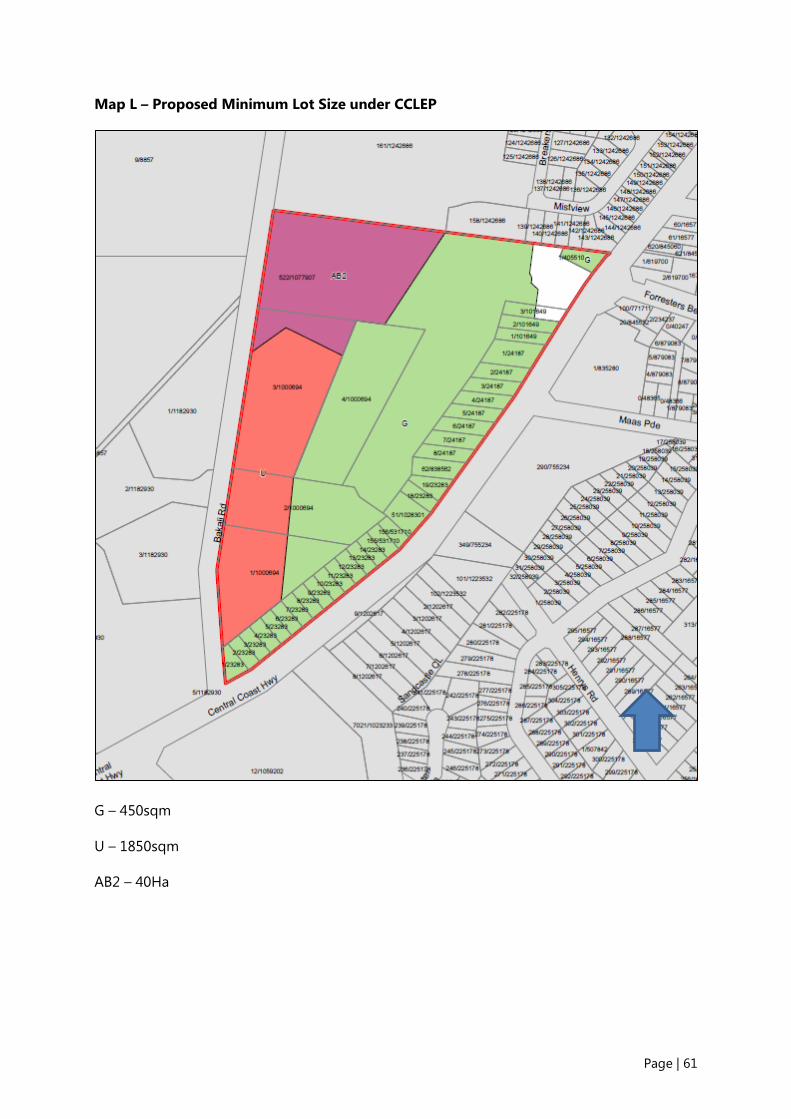
Page | 61
Map L – Proposed Minimum Lot Size under CCLEP
G – 450sqm
U – 1850sqm
AB2 – 40Ha

Page | 62
Map M – Proposed Height of Building under GLEP 2014
I – 8.5m

Page | 63
Map N – Proposed Floor Space Ratio under GLEP 2014
D – 0.5:1

Page | 64
Map O – Proposed Acid Sulfate Soils under GLEP 2014
5 – Class 5

Page | 65
Supporting Documentation
No. Document
01 Assessment and Endorsement
A. Council Report and Minutes – 2 July 2013
B. Gateway Determination
C. Gateway Extension 1
D. Gateway Extension 2
E. Gateway Extension 3
F. Gateway Extension 4
G. Gateway Extension 5
02 Statutory Documents
A. State Environmental Planning Policies
B. Ministerial Directions under Section 9.1
C. Central Coast Regional Plan 2036
D. Gosford Local Environmental Plan 2014
03 Agency Responses
A. NSW Rural Fire Service
B. Office of Environment and Heritage
C. Roads and Maritime Service
04 Mapping
A. Existing Zone under Interim Development Order No 122
Proposed Provisions under GLEP 2014
B. Land Application Map LAP_001
C. Land Zoning Map LZN_ 017A Existing Map Tile
Land Zoning Map Site Identification
Land Zoning Map LZN_017A New Map Tile
D. Floor Space Ratio Map FSR_ 017A Existing Map Tile

Page | 66
No. Document
Floor Space Ratio Map Site Identification
Floor Space Ratio Map FSR_017A New Map Tile
E. Height of Building Map HOB_ 017A Existing Map Tile
Height of Building Map Site Identification
Height of Building Map HOB_017A New Map Tile
F. Lot Size Map LSZ_ 017A Existing Map Tile
Lot Size Map Site Identification
Lot Size Map LSZ_017A New Map Tile
G. Acid Sulfate Soils Map ASS_017A Existing Map Tile
Acid Sulfate Soils Map Site Identification
Acid Sulfate Soils Map ASS_017A New Map Tile
Proposed Provisions under Draft CCLEP
H. Proposed Land Zone under Draft CCLEP (as exhibited)
Proposed Change to Land Zoning Map
Proposed Change included in Land Zoning Map
I. Proposed Lot Size under Draft CCLEP (as exhibited)
Proposed Change to Lot Size Map
Proposed Change included in Lot Size Map
05 Supporting Studies
A. Planning Proposal Application document
B. Flora and Fauna Assessment Report
C. Bushfire Assessment Report
D. Aboriginal Cultural Heritage Assessment Report
E. Flood Study
F. Stormwater Management Plan
G. Urban Capability Assessment
H. Water and Sewer Analysis
I. Traffic Report

Page | 67
No. Document
06 Gosford Development Control Plan 2013
A Proposed New Chapter in Gosford Development Control Plan 2013
Table 9: Supporting Documentation to the Planning Proposal