Central Asia and the Aral Sea Basin - Hydrology.nl • Portal to...
14
Transcript of Central Asia and the Aral Sea Basin - Hydrology.nl • Portal to...


Central Asia and the Aral Sea Basin

The very early days of irrigated agriculture
Turkmenistan is the cradle of irrigated farming in Central Asia. Twenty seven mountain streams flow down from the northern slopes of the Kopet Dagh Ridge. These were the basis for settled life in the two oases at Akhal-Tekin and Atrek. Using small barrages, farmers created a manmade micro-relief for irrigating their fields. There was no need to build any special structures for flooding fields, since it was sufficient to build small embankments along the edges of the fields to retain water for a period of time. These rather primitive methods initiated the development of irrigation in Central Asia.

Opening Up / The Silk Road
This trade route is usually attributed to Chinese diplomats of the Han dynasty. In 135 BC, the envoy Zhang Qian returned to China after ten years spent travelling through Central Asia. He brought the news about the great potential of this region to the Chinese Emperor Wudi (who ruled 141–87 BC). Water for the caravanes was an essential part of the lifeblood of this trade route. The remains of ancient wells and water works can still be found in the region today.
Sardoba

Early Technical Infrastructure Development
The Abdullahandandi dam
Water management structures were beingdeveloped already very early on. One ofthe first interbasin canals, theEskytujatartar Canal was built in thefourteenth century and was more than 60km long. It had a carrying capacity of 30–35 m3/sec and was constructed fordiverting water from the Zeravshan River.The Abdullahandandi dam of 25 metershigh 25 m high was built at the foot of theNurata mountains in the tenth century AD.The stone masonry dam, which still existstoday, has a storage reservoir with acapacity of 1.5 million m3, which is nowcompletely silted up. These earlystructures announced the arrival of an evermore complex and large size irrigationinfrastructure in Central Asia.

History of the Aral Sea
Since ancient times the Aral Sea and the delta’s of the Amudarya and of the Syrdarya have plaid a key role in the development of irrigated agriculture in Central Asia. The level of the Aral Sea has changed depending on wet and dry climate conditions between higher than 72 MBSL (Mean Baltic Sea Level) to completely dry, when for example the Amudarya discharged into the Caspian Sea through the Uzboy channel. The largest drop in the Aral Sea level was observed at the beginning of the nineteenth century, when by 1846 large parts of the former sea had turned into vast desert areas. Today, as a result of overexploitation of water for irrigated agriculture mainly, the levels have dropped to below 30 MBSL. Reconstruction of the geography of
Central Asia based on historical data

Russian Colonization
Map of Central Asia (Turkestan) by Massalsky (1913)
The Russian tsarist government decided to institutionalize the pre-colonial land and water relations in Turkistan in Central Asia on June 12, 1886, when Tsar Alexander II approved the so-called Regulations for Governance of Turkistan Krai. These krais (provinces) became large administrative units in the Soviet territorial system in 1924. The Russians started to develop irrigated agriculture first following the example of the British led large scale irrigated agriculture development model in India. The Turkistan Administration of Irrigation Works (IRTUR) was established to lead the challenge towards large scale irrigated agriculture development in Central Asia and cotton became the main product.
Cas
pian
S
ea
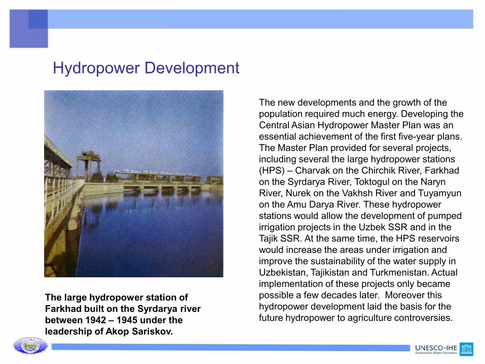
Hydropower Development
The new developments and the growth of the population required much energy. Developing the Central Asian Hydropower Master Plan was an essential achievement of the first five-year plans. The Master Plan provided for several projects, including several the large hydropower stations (HPS) – Charvak on the Chirchik River, Farkhad on the Syrdarya River, Toktogul on the Naryn River, Nurek on the Vakhsh River and Tuyamyun on the Amu Darya River. These hydropower stations would allow the development of pumped irrigation projects in the Uzbek SSR and in the Tajik SSR. At the same time, the HPS reservoirs would increase the areas under irrigation and improve the sustainability of the water supply in Uzbekistan, Tajikistan and Turkmenistan. Actual implementation of these projects only became possible a few decades later. Moreover this hydropower development laid the basis for the future hydropower to agriculture controversies.
The large hydropower station of Farkhad built on the Syrdarya river between 1942 – 1945 under the leadership of Akop Sariskov.

Large scale, modernized, irrigation development
In August 1950, the government of the USSR adopted a resolution on the transition towards new irrigation systems that foresaw in improved use of irrigated lands, larger irrigated units up to a size suitable for highly mechanized land treatment (8–10 hectares), the replacement of permanent field irrigated networks with temporary irrigated ditches, and (most importantly) the leveling of irrigated lands. These activities under the fourth and fifth five-year plans (1946–1950 and 1951–1956) were accompanied by modernized and standardized mechanization of construction and repair works, as well as the introduction of heavy machinery for development and maintenance of irrigation canals and structures. First activities concentrated on the Syrdarya. Later on the engineers moved to the Amudarya with plans for hydropower systems up to a capacity of 100,000 kW, and support irrigation of 1,300,000 hectares in the southern districts of the Trans-Caspian plain in Western Turkmenistan (Karakum Canal).
Map of the Karakum Canal (headflow is 550 m3/sec) region. Works started as early as 1953, with the establishment of camps in Mary City by Sredazgidrostroy.
Karshi Irrigation Systems

Towards Independent States in Central Asia
The Sib-Aral project was one latest answer to the increasing problems with the management and allocation of water resources in Central Asia
By the end of the 1980’s, shortly before the brakeup of the Soviet Union, the Central Asian states were left with an infrastructure which was largely undermaintained and suffering from problems related to allocation of water to the main users Irrigated Agriculture and Hydropwer.
From a one union management and decision making system Central Asia had to move towards a multi country, multi stakeholder situation. One early answer was the establishment of the Interstate Commission for Water Coordination (ICWC) and the Agreement on Co-operation in the Field of Joint Water Resources Management and Conservation of Interstate Sources (October 12, 1991)

Water Management Organization in Central Asia
Soon after independence the Central Asian states developed a new institutional infrastructure to deal with transboundary water management problems.
The Central Asian states try to find each other on water allocation problems by setting up new management structures and regional bodies. One important milestone was the Nukus declaration (1994), which adopted a common socio-economic and environmental policy for the region.
International donors started to play a role in the region through the Aral Sea Basin Program 1 that was adopted in a donor meeting in Paris in 1994. The ASBP- 3 is due to start in 2011

Water Scenario’s / What are we afraid of ?
Assuming a population growth rate and replenishment of renewable water resources at present levels, water availability in Central Asia should be sufficient for the next 25 years. Even by 2030, under a pessimistic scenario (little innovation; little cooperation), the available water resources per capita in the region would amount to 1430 m3 per person per year, which is much more than in countries with a real high water deficit such as Israel and Jordan.
There are three groups of threats that tend to be highlighted:
i) internal threats (incompleteness of political reforms and the unsatisfactory socioeconomic situation),
ii) regional threats (contradictions and challenges in political, socioeconomic and environmental policies) and
iii) external threats (geopolitical forces that play a role in Central Asia and the situation in the neighboring countries).
All suggest that the five countries (plus Afghanistan) are “doomed” to co-operate as the only way to withstand regional threats and as a tool to facilitate the settling of internal problems in each country.
Future Developments / Balancing Interests / Some Facts
The secret is in balancing national and regional interests per sector in an atmosphere of transparancy. Some of the presently reported events and approaches are:
• new geopolitics in the region include the construction of the Atasu-Alashankau oil pipeline, with a carrying capacity of 10 million tons a year (to increase to 20 million ton in the future), in a project implemented by Kazakhtranskoil and the China National Oil Development Corporation in 2005
• in 2006, the governments of Turkmenistan, Kyrgyzstan, Afghanistan and Pakistan signed a memorandum to develop a regional power market (KISI 2008).
• the United States, is reportedly initiating efforts to create a “water bridge" between Afghanistan and Tajikistan for the development of hydropower facilities on the Panj River. This in particular concerns the Dasht and Dzune Hydropower Plant (design capacity 3 million kW).
• in 2003 a draft agreement prepared by the RAO UES of Russia on the transfer of surplus electrical power from Central Asia to Russia was signed
• In October 2004 a Russian Tadjiek agreement on long-term co-operation between RUSAL (an open joint stock company) and the government of the Republic of Tajikistan concerning the RogunHydropower Plant construction phase I project was signed
• Between 2004 to 2009 the RAO UES of Russia undertook construction of the Sanguta Hydropower Plant 2.
• Are these the actions leading to the balanced water sharing scheme that should serve common interests ? IWRM is the belief of today, but the future of Central Asia likely is with politicians rather than with economists and engineers.

www.unesco-ihe.orgwww.sic.icwc-aral.uz
www.cawater-info.net