CENTER TO GRAND FORKS 345 KV TRANSMISSION ... TO GRAND FORKS 345 KV TRANSMISSION LINE PROJECT...
52
CENTER TO GRAND FORKS 345 KV TRANSMISSION LINE PROJECT ENVIRONMENTAL ASSESSMENT COMMENT REPORT March 2011 U.S. Department of Agriculture Rural Utilities Service
Transcript of CENTER TO GRAND FORKS 345 KV TRANSMISSION ... TO GRAND FORKS 345 KV TRANSMISSION LINE PROJECT...
CENTER TO GRAND FORKS 345 KV TRANSMISSION LINE
PROJECT
ENVIRONMENTAL ASSESSMENT
COMMENT REPORT
March 2011
U.S. Department of Agriculture Rural Utilities Service


Rural Utilities Service EA – Comment Report Center to Grand Forks Project
March 2011 i Table of Contents
Table of Contents 1.0 Introduction ....................................................................................................... 1-1
1.1 Project Overview............................................................................................................. 1-1 1.2 Project Purpose ............................................................................................................... 1-3 1.3 Review Process and Procedures ................................................................................... 1-4 1.4 Comment Methodology ................................................................................................. 1-4
2.0 Comments and Responses ................................................................................. 2-1

Rural Utilities Service EA – Comment Report Center to Grand Forks Project
March 2011 1-1 Introduction
1.0 Introduction Minnkota Power Cooperative, Inc. (Minnkota) is a generation and transmission cooperative serving 11 rural electric distribution cooperatives. Minnkota requested financing assistance from the U.S. Department of Agriculture (USDA) Rural Utilities Service (RUS) to construct an electric transmission line and associated facilities in central and northeast North Dakota. The RUS, an agency that administers the USDA’s Rural Development Utilities Program, is required to complete an environmental analysis prior to approving financial assistance. In accordance with RUS’ Environmental Policy and Procedures for Implementing the National Environmental Policy Act (NEPA) (7 Code of Federal Regulations (CFR) Part 1794), the proposed Center to Grand Forks 345 kV Transmission Line Project (Project) was classified as an Environmental Assessment with scoping (EA).
The purpose of the EA is to:
• Discuss the proposed Project’s purpose and need • Evaluate the potential environmental effects of the proposed Project • Consider reasonable and feasible alternatives • Explore mitigation measures for reducing adverse impacts • Provide information to the public and Project decision makers
Prior to the EA, a Macro-Corridor Study (MCS) was developed to begin the process of identifying corridors for potential routes. Development of the MCS was a tiered process that narrowed a large study area into preliminary study corridors and then into macro-corridors. The MCS provided information about environmental, land use, social, cultural, and permitting factors for the macro-corridors. The macro-corridors evaluated for the proposed Project were typically 6-miles-wide, while some portions of the macro-corridors were 8-miles-wide, such as near the Milton R Young Unit 2 Generation Station (Young 2) and the Prairie Substation. As part of the EA, 191 route segments were analyzed consisting of narrower areas, approximately 1,000-feet-wide, located within the macro-corridors. The route segments would be joined to form a route alternative. After a through review, 39 of the 191 route segments were eliminated from inclusion in the route alternative analysis. Three 1,000-foot-wide route alternatives were selected and reviewed in detail (Routes A, B, and C) along with 38 1,000-foot-wide segment alternatives. In Section 4.0 of the EA, Route A was defined as the preferred route alternative for the proposed Project.
As described in more detail in Section 1.3 below, the RUS issued the EA for the proposed Project on November 12, 2010. Under the applicable rules, RUS must respond to the timely comments received on the EA. Comment may aid the RUS in making a determination on the proposed Project.
1.1 Project Overview Minnkota proposes to construct, operate, and maintain approximately 247 miles of new, high voltage alternating-current (AC) transmission line from their existing Center 345 kV Substation at the Milton R. Young Generation Station located about 4.5 miles southeast of the town of Center, North Dakota in Oliver County, to their existing Prairie Substation located on the western boundary of the city of Grand Forks, North Dakota in Grand Forks County. The Project will deliver energy from existing baseload generation to Minnkota’s cooperative members. While final engineering and design have not been completed, the majority of the line
Center to Grand Forks Project Rural Utilities Service EA – Comment Report
Introduction 1-2 March 2011
will be constructed with single-pole steel structures. Typical structures will be approximately 140-feet-high and placed approximately 1,000-feet apart. The typical right-of-way (ROW) will be approximately 150-feet-wide.
In addition to the transmission line, the proposed Project would consist of the following major components:
• Center 345 kV Substation Upgrades – Most upgrades (circuit breakers, dead-end structures, new transformer and associated bus work, switches and associated foundations, steel structures, and control panels) would occur within the existing substation’s fenced boundary. A line reactor for open line voltage control may also be required. If the reactor is required, a 22,500 square foot (0.5 acre) expansion to the north end of the substation, beyond the existing fenced boundary, would be needed.
• Additional 230 kV Tie Line – Approximate 1,500-feet-long Tie Line would parallel the existing tie line on Minnkota-owned property. It is required to complete the transmission-to-transmission interconnection between the Square Butte 230 kV Substation and Center 345 kV Substation.
• Square Butte 230 kV Substation Upgrades – Existing 230 kV circuit breakers and line terminal equipment would be re-allocated to the new 345 kV interconnect.
• Prairie Substation Upgrades – All upgrades (circuit breakers, dead-end structures, transformers and associated bus work, switches, associated foundation, steel structures, and control panels) would occur within the existing substation’s fenced boundary.
• Fiber Optic Regeneration Stations – Four fiber optic regeneration stations with permanent access roads would be require along the transmission line route to re-amplify the protection and control signals carried in the optical ground wire (OPGW).
• Proposed Project Access and Crossings of State Highway - The proposed transmission line would cross state highways at 45 locations. Construction access to the proposed route alternatives may take place at the 45 crossing locations. Ten of the 45 potential construction access locations may require a temporary impact within North Dakota Department of Transportation ROW.
• Staging Areas – Up to 14 temporary staging areas may be established for the proposed Project. Twelve staging areas would be located along the proposed route, one staging area would be located at the Center 345 kV Substation, and one staging area would be located at the Prairie Substation.
• Relocation of Transmission Line Structures at the Center 345 kV Substation - Relocate sections of the Center to Jamestown 345 kV Transmission Line and existing 230 kV Tie Line.
• Relocation of Transmission Line Structures at the Prairie Substation - Relocate a section of the Prairie to Western Area Power Administration (WAPA) Substation 230 kV Transmission Line.
• Underground of Distribution Lines - Where site specific considerations require, such as areas where line clearance may be an issue or other ROW concerns, Minnkota would bury existing distribution lines within the distribution line’s existing ROW.

Rural Utilities Service EA – Comment Report Center to Grand Forks Project
March 2011 1-3 Introduction
1.2 Project Purpose Over the past 10 years, Minnkota’s load has grown at a rate of 2.9 percent annually (Alternative Evaluation Study). In addition, Minnkota’s 2009 Load Forecast Study showed that load will continue to grow at a rate of approximately 1.9 percent annually over the next 25 years. In order to adequately serve this future load growth, Minnkota must increase its baseload generation resources. In particular, additional baseload generation is needed by the winter of 2013 to address an increased need for electricity use to serve new residences, commercial accounts, and pipeline pumping projects.
To address the need for additional baseload generation resources, Minnkota recently entered into an agreement to amend an existing power purchase agreement (PPA) with Minnesota Power, a division of ALLETE, and Square Butte Electric Cooperative (Square Butte). Pursuant to this agreement, Minnesota Power released to Minnkota the rights to its share of generation from the Square Butte-owned Young 2 generation station. This allows Minnkota to increase its allocation of generation from Young 2 from 50 percent to 100 percent over the next several years. In return, Minnkota has agreed to release its rights for transmitting power from Young 2 via the Square Butte high-voltage direct-current (HVDC) transmission line that terminates near Duluth, Minnesota. Square Butte, in turn, sold the HVDC transmission line to Minnesota Power. The new agreements between Minnkota, Minnesota Power, and Square Butte provide Minnkota with additional baseload power supply without the need to construct a new coal-fired plant, and provide Minnesota Power with existing transmission facilities to develop and deliver substantial wind energy from North Dakota to its consumers in Minnesota.
The agreement with Minnesota Power and Square Butte will enable Minnkota to begin acquiring additional baseload generation from Young 2 in early 2013. However, because the existing HVDC transmission line will no longer be available to carry the full generation output of Young 2, the power generated by Young 2 will need to be transmitted via the AC transmission system to Minnkota’s service territory in eastern North Dakota and western Minnesota.
Regional transmission-system studies for the eastern North Dakota and northwestern Minnesota area since 2005 have demonstrated the need for improvements due to systemic voltage instability and load serving issues. In addition, these studies have found that the existing AC transmission system is already operating at capacity without any additional load growth. System studies indicate that additional transmission into the northeastern part of North Dakota from the area of concentrated generation in central North Dakota is the preferred alternative in order to address these issues within Minnkota’s service territory. The purpose of this proposed Project is to address future load growth, system voltage stability, and load serving issues in Minnkota’s service territory. In order to fulfill its obligations for future load growth, Minnkota must increase its baseload generation resources.
The proposed Project would provide a direct link to Minnkota’s service territory, while providing a major improvement to the regional transmission grid and a sound technical solution to the northern Red River Valley voltage stability issue, which is documented in the Alternative Evaluation Study (AES). The proposed Project has the potential to support wind generation development in North Dakota. Therefore, the proposed Project would be the optimal alternative to address the needs of Minnkota’s service area and the region.
Center to Grand Forks Project Rural Utilities Service EA – Comment Report
Introduction 1-4 March 2011
1.3 Review Process and Procedures RUS, an agency which administers the USDA’s Rural Development Utilities Programs, may provide financing assistance for the construction of these facilities. RUS is following its policies and procedures, 7 CFR Part 1794 Environmental Policy and Procedures for implementing the NEPA, in order to assure compliance with NEPA and related laws, regulations, and executive orders. In doing so, RUS worked with the local, state, and federal agencies with expertise in their resources, as well as Native American tribes and interested consulting parties to evaluate the potential environmental impacts of the proposed Project. Prior to the making a decision on approving a loan for the proposed Project, an EA for the proposed Project must be completed. Following RUS guidance, Minnkota began the project development process by preparing an AES to identify the proposed Project’s purpose and need and alternatives for meeting capacity requirements and also prepared a MCS to begin the process of identifying a corridor for potential routes. The AES and MCS were published by the RUS on October 22, 2009. A scoping process was initiated to provide the public, federal, and state agencies, and local governments with information regarding the description, need, and potential project locations or routing, identify concerns of the proposed Project, discuss compliance and permitting requirements, and gather information to be addressed in the RUS’s environmental review and documentation. Comments received during the scoping process are summarized in a Scoping Report which was published by RUS on March 2, 2010. All comments identified through the scoping process were reviewed and considered in development of the EA.
Following publication of the EA in November 2010, a 30-day public comment period was held from November 15 to December 17, 2010. This Comment Report provides responses to comments received the 30-day comment period.
The MCS, AES, Scoping Report, and EA prepared for the proposed Project can be found at: http://www.usda.gov/rus/water/ees/ea.htm#Minnkota_Power_Cooperative,_Inc._.
1.4 Comment Methodology A total of 47 respondents commented on the EA during the comment period (November 12 to December 17, 2010). RUS staff considered and responded to comments to the extent practicable. Each comment received was assigned a comment ID number. The comment responses include the comment source (email, letter, Project website, Project hotline, or phone call). These responses are outlined in Section 2.0. Unless otherwise noted, comments are verbatim; however private contact information (phone number and address of the commenter) was redacted from this Comment Report.

Rural Utilities Service EA – Comment Report Center to Grand Forks Project
March 2011 2-1 Comments and Responses
2.0 Comments and Responses All comments received by the RUS on the proposed Project were reviewed and a response was developed for all substantive comments.
Throughout Project development initiated in the spring 2009, Project comments have been collected in a comment database and assigned an ID number. To maintain an accurate comment database, the assigned comment ID numbers were not modified for this report. The first comment collected during the EA comment period begins with number ID 303. Table 2.0-1 is a summary of all the comments received during the EA comment period. Provided below Table 2.0-1 is the comment number, the source of the comment, commenter’s name, verbatim comment, and a comment response.
Table 2.0-1. Summary of Project Comments
Comment No.
Commenter Comment Topic Date of
Submission Method of Comment
303 Walcker, Jeff Routing 11.19.10 Hotline 304 Jans, David Aesthetics, Property Values 11.19.10 Website
306/322 Widicker, Gary ROW Acquisition/Easements, Agriculture Impacts, Construction Impacts, Annual Payments
12.1.10/ 12.10.10 Hotline/Website
307/310 Gunderson, Marsha Routing, Environmental Impacts, Aesthetics 11.22.10 Website/Email
308 McShane, Jolie (Power Line Services Inc.) Mailing List Request 11.22.10 Website
309 Brandt, Keith Routing 11.25.10 Website
311/332 Peterson, Rodney & Ann General Comment, Missouri River 11.23.10/12.6.10 Phone/Letter
312 Ackerman, Laura (ND State Water Commission)
Permitting 11.22.10 Email
313 Boote, Alan & Nikki (Boote Septic Solutions)
Vendor 12.1.10 Email
314/357 Douglas Handt Routing, Request for Environmental Assessment, Environmental Impacts 12.1.10/12.11.10 Letter
315 Paaverud, Merlan (ND SHPO) General Comment 11.18.10 Letter
316 Glatt, David (ND Dept of Health) Construction 11.19.10 Letter
318 Skadberg, Doug Routing 12.3.10 Hotline
319/349 Hanson, Jesse (ND Parks and Rec Dept) Routing 12.7.10/12.10.10 Email/Letter
320 Nygaard, Donald Mailing List Request 12.8.10 Hotline 321 Carlson, Garvin Environmental Impacts 12.4.10 Letter

Center to Grand Forks Project Rural Utilities Service EA – Comment Report
Comments and Reponses 2-2 March 2011
Comment No.
Commenter Comment Topic Date of
Submission Method of Comment
323 McShane, Christopher (Ohnstad Twichell Attorneys)
Routing 12.13.10 Letter
324 Thompson, James Sheyenne River Riparian Areas, Erosion, Species/Habitat 12.13.10 Letter
325 Hagert, Jared Routing, Environmental Impacts, Cultural Resources 12.11.10 Letter
326 Grefsheim, Harley Routing, Environmental Impacts, Cultural Resources 12.11.10 Letter
327 Hancock, Donn Routing, Environmental Impacts, Cultural Resources 12.11.10 Letter
328 Hagert, Curtis Routing, Environmental Impacts, Cultural Resources 12.11.10 Letter
329 Knudtson, Dave Routing, Environmental Impacts, Cultural Resources 12.11.10 Letter
330 Orion, Sanda Routing, Environmental Impacts, Cultural Resources 12.11.10 Letter
331 Barr, Randy Routing, Environmental Impacts, Cultural Resources 12.11.10 Letter
333 Knudtson, Larry (ND State Water Commission)
Permitting 12.7.10 Letter
334 Henke, Ronald (ND Dept. of Transportation)
Permitting 12.3.10 Letter
335 Rauser, Kenneth & Launa Routing 12.16.10 Website
336 Weckerly, Cole Routing, Land Use 12.17.10 Email
337/340 Weckerly, Chad and Tessa Routing, Land Use 12.17.10 Email
338 Weckerly, Norman & Lou Routing, Land Use 12.17.10 Email
339 Weckerly, Terry Routing, Land Use 12.17.10 Email
341 Leake, Todd (Grand Forks Farmer’s Union) Routing, Environmental Impacts 12.17.10 Email
342 Welte, Peter Routing 12.17.10 Email
343 Weekley, Mark (US Dept of the Interior) Aesthetics 12.17.10 Email
344 Shearer, Ann General Comment 12.17.10 Hotline 345 Clayburgh, John Routing, EMF, Health and Safety 12.14.10 Letter 346 Ryan & Prairie Topp EMF, Health and Safety 12.18.10 Email
347 Schockley, John (Ohnstad Twichell Attorneys)
EMF, Routing 12.29.10 Email

Rural Utilities Service EA – Comment Report Center to Grand Forks Project
March 2011 2-3 Comments and Responses
Comment No.
Commenter Comment Topic Date of
Submission Method of Comment
348 Bushee, Jeremy Routing, Environmental Impacts, Cultural Resources 12.11.10 Letter
350 Jorde, Allen Routing, Environmental Impacts, Cultural Resources 12.10.10 Letter
351 Johnson, Jean Easements 12.14.10 Letter
352 Bailey, Tracy Routing, Environmental Impacts, Cultural Resources 12.11.10 Letter
353 Heron, Jim & Terri Environmental Impacts 12.10.10 Letter
354 Sherod, Chad Routing, Environmental Impacts, Cultural Resources 12.11.10 Letter
355 Thompson, Jim Environmental Impacts 12.10.10 Letter
356 Schaar, Jerome (USDA-Natural Resources)
Agricultural Impacts, Wetlands 12.15.10 Letter
COMMENT #: 303 COMMENT SOURCE: HOTLINE
Jeff Walcker
Yes, I would like to talk to someone to see exactly where the proposed route is going to be. On the website on the map, it's too vague. You can't tell which quarter line and section line you're planning on going to go down. My concern is about 14579 Section 32 and Section 28 because I'm planning on putting up irrigation systems and I don't want it going down that quarter line. If someone could get a hold of me, I'd sure appreciate it.
Comment:
EA Reference:
Section 3.2, Appendix B
Appendix B of the Environmental Assessment contains detailed route maps of Routes A, B, C, and the segment alternatives reviewed. Route C crosses T145, R79 Section 28 NW¼ and Section 32 NW¼. Route A crosses T145, R79 Section 32 SE¼ . According to the Environmental Assessment, Route A is the preferred route. The right-of-way acquisition process will occur following approval of a final route through the North Dakota Public Service Commission’s (PSC) Certificate of Corridor Compatibility and Route Permit Application processes that are currently taking place and this comment will be considered for the PSC Applications. Details of final pole placement will be negotiated with property owners during final design.
Response:

Center to Grand Forks Project Rural Utilities Service EA – Comment Report
Comments and Reponses 2-4 March 2011
COMMENT #: 304 COMMENT SOURCE: WEBSITE
David Jans
I built my house in an area that I have a great view. I hope that this will not reduce my visibility and my property value. Your line is going to be in my direct line of sight.
Comment:
EA Reference:
Section 3.11, Section 3.14
Section 3.11 of the Environmental Assessment describes potential visual and aesthetic impacts of the proposed Project and mitigation for those impacts. Aesthetics refer to the natural and human modified landscape features or visual resources that contribute to the public’s experience and appreciation of the environment. The level of impact to visual resources generally depends on the sensitivity and exposure of a particular (subjective) viewer and can vary greatly from one individual to the next. It is, therefore, difficult to predict to what degree a transmission line project would alter the perceived visual character of the environment, or view shed, and constitute a negative visual impacts.
Response:
As outlined in Section 3.11 of the Environmental Assessment, visual impacts may occur one-half to three-quarters mile from structure. The occupied residence identified on your property is approximately 0.6 miles south and approximately 1.1 miles west of Route A as defined in the EA. Mitigation methods in these areas could be implemented such as strategic pole placement during final design as well as landscape or vegetation design to minimize any perceived aesthetic impacts. As in any route permit application, final engineering for pole placement and construction requirements have not been fully developed because a final route has not been determined.
Minnkota attend a Painted Woods Township meeting after receiving an invitation. Many residents in attendance repeated the comment to minimize visual impacts to the Missouri River from their residences. Therefore, Minnkota deemed the visual impact of paralleling the Missouri River was a higher priority than land use impacts to the residents of Painted Woods Township. Therefore, with the assistance of the community, Minnkota developed a revised route through the Painted Woods Township to reduce visual impacts to the Missouri River.
COMMENT #: 306 COMMENT SOURCE: HOTLINE
Gary Widicker
Wells County, Speedwell Township. A mile and a quarter of line across my land…compensation in regard to compaction issues, crop loss … I need compensation annual per pole. No different than wind tower or a cell tower … serves the public as well … Five year look in regard to inflation adjustment. Those are my concerns.
Comment:
EA Reference
Section 1.5.3, Section 3.2.2, Section 3.2.3, Section 3.14.3, Appendix B
:

Rural Utilities Service EA – Comment Report Center to Grand Forks Project
March 2011 2-5 Comments and Responses
Appendix B of the Environmental Assessment contains detailed route maps of Route A, B, C, and segment route alternatives reviewed. Route B is routed through Speedwell Township. According to the Environmental Assessment, Route A is the preferred route that does not cross Speedwell Township.
Response:
As discussed in Section 3.2.2 of the Environmental Assessment, soil compaction would occur during construction and mitigation measures as outlined in Section 3.2.3, compacted soils would be restored using a deep tillage practice.
The easement acquisition process is outlined in Section 1.5.3 of the Environmental Assessment. The easement acquisition process and compensation would be discussed with potentially affected landowners by a right-of-way agent.
COMMENT #: 307 COMMENT SOURCE: E-MAIL
Marsha Gunderson
I have commented before, but nothing has changed. The option A line passes over my farmstead. As it sits, I would lose the entire south grove of trees with a 75 foot right of way. Avon Twp, Grand Forks Co., T150N R54W Sec 32 This is an occupied farmstead. It is currently rented. The map makes it look unoccupied as there is no little yellow dot on it.
Comment:
Section 3.2
EA Reference:
The North Dakota Public Service Commission’s (PSC) guidelines require that the transmission facilities are no closer than 500 feet from a residence unless a waiver is granted (NDCC Rules 69-06-08-02). The proposed Project maps have been updated to indicate that the property in Avon Township is correctly identified as occupied. The route has been modified to address concerns. The route has been modified by moving the current Route A to the north by approximately 800 feet to follow the PSC’s rule and the reduce impacts to the windbreaks.
Response:
Minnkota will work to minimize impacts to tree groves during the detail engineering design.
COMMENT #: 308 COMMENT SOURCE: WEBSITE
Jolie McShane
Mailing List Request
Comment:
EA Reference
NA
:
Power Line Services, Inc. has been added to the proposed Project mailing list and will receive future mailing notifications regarding the Center to Grand Forks Project.
Response:

Center to Grand Forks Project Rural Utilities Service EA – Comment Report
Comments and Reponses 2-6 March 2011
COMMENT #: 309 COMMENT SOURCE: WEBSITE
Keith Brandt
Interested in any route changes in the Hatton area.
Comment:
EA Reference
NA
:
The Environmental Assessment has identified Route A as the preferred route. Segment Alternative A27 is located approximately 1 mile east of the City of Hatton. Minnkota will continue to update their proposed Project website with the most current routing maps (www.minnkotacgf.com). Please continue to check this website for route modifications. You have also been added to the proposed Project mailing list and you will be notified of proposed Project announcements via direct mail.
Response:
COMMENT #:310 COMMENT SOURCE: EMAIL
Marsha Gunderson
Under option A, the proposed line runs directly through my family farmstead. Even if it were moved to the south of 6th Avenue North, I believe, there is the potential to lose the entire grove of trees on the south side of the farmstead. I have attached a pdf indicating the location of the farmstead which is circled in yellow. It is currently occupied, even though the map does not indicate as such with a yellow dot. I am very concerned about not only losing the windbreak value of the trees, but also the damage to the aesthetic value of my property. Location: Avon Twp., Grand Forks County R150N R54W Sec 32.
Comment:
EA Reference
Section 3.2
:
See response to comment #307
Response:
COMMENT #: 311 COMMENT SOURCE: PHONE
Rodney and Ann Peterson
Minnkota received a call from Rodney Peterson from Wilton, ND stating that he does not have internet access and requested a route map.
Comment:
EA Reference
NA
:
Minnkota provided the locations of the EA for review.
Response:
Rural Utilities Service EA – Comment Report Center to Grand Forks Project
March 2011 2-7 Comments and Responses
COMMENT #: 312 COMMENT SOURCE: EMAIL
Laura Ackerman - North Dakota State Water Commission
The North Dakota State Water Commission and Office of the State Engineer received your solicitation of comments notice for Minnkota's Center to Grand Forks Transmission Line Project. The Environmental Assessment document already states that a sovereign lands permit may be needed to cross certain water bodies in North Dakota. Based on the proposed alternative routes, sovereign lands permits will be required for crossing the Missouri River, James River, and Sheyenne River. A separate sovereign lands permit is required for each crossing.
Comment:
EA Reference:
Section 3.7.3, Section 6.0
Section 3.7.3 of the Environmental Assessment discusses the requirement to obtain Sovereign Lands Permits. We understand that sovereign lands are those areas, including beds and islands, lying within the ordinary high watermark of navigable lakes and streams. Routes A, B and C all cross the Missouri River, James River, and Sheyenne River. No direct short-term or long-term impacts to watercourses are expected as part of the construction and operation of the transmission line and associated facilities. Applicable BMPs would be utilized to prevent indirect impacts due to runoff, erosion and sedimentation, or blockage of drainageways. Once a final route is selected, Minnkota will contact the North Dakota State Water Commission and Office of the State Engineer and apply for a Sovereign Lands Permits for the identified crossings. Potential permits and approvals are listed in Table 6.0-1 of Section 6.0.
Response:
COMMENT #: 313 COMMENT SOURCE: PHONE
Alan and Nikki Boote
Alan Boote called regarding portable toilet service for the construction of the CGF Transmission Line.
Comment:
EA Reference
NA
:
This comment is not regarding the Environmental Assessment. Minnkota told Alan that the proposed Project is in the permitting process and have not determined construction vendors at this stage. Alan Boote was added to the list of vendors and would be contacted if services are needed.
Response:

Center to Grand Forks Project Rural Utilities Service EA – Comment Report
Comments and Reponses 2-8 March 2011
COMMENT #: 314 COMMENT SOURCE: LETTER
Douglas Handt
Would you please send me a copy of the assessment? I don't have a computer. I have to review it before a final decision since it pertains to N. Dak and some of my connected tributaries, etc…I know where the proposed transmission line is going to be placed asap.
Comment:
EA Reference
NA
:
A hard copy of the Environmental Assessment was mailed to Douglas Handt on December 6, 2010.
Response:
COMMENT #: 315 COMMENT SOURCE: LETTER
Merlan Paaverud - State Historical Society of North Dakota
We reviewed the Environmental Assessment on ND SHPO Ref: 10-0173 RUS Environmental Assessment for Minnkota Power Cooperative's proposed Center to Grand Forks Transmission Line Project, North Dakota. We look forward to further consultation on the project. Compliance and cultural resource protocols are outlined in Sections 3.10 and 3.11 (pp. 3-85 to 3-93). Thank you for the opportunity to review this document. We look forward to further consultation. Please include ND SHPO reference number listed above in further correspondence for this specific project. If you have any questions contact Susan Quinell, Review and Compliance Coordinator at (701) 328-3576 or [email protected].
Comment:
EA Reference
Section 3.10, Section 3.11, Section 6.0
:
Minnkota will continue to consult with the North Dakota State Historic Preservation Office (SHPO) through proposed Project development. Following completion of the Class III cultural resources survey report, Minnkota will submit it for SHPO review.
Response:
COMMENT #: 316 COMMENT SOURCE: LETTER
David Glatt - North Dakota Department of Health
This department has reviewed the information concerning the above-referenced Environmental Assessment submitted under date of November 9, 2010. This department believes that environmental impacts from the proposed construction will be minor and can be controlled by proper construction methods. With respect to construction, we have the following comments:
Comment:
All necessary measures must be taken to minimize fugitive dust emissions created during construction activities. Any complaints that may arise are to be dealt with in an efficient and effective manner.
Rural Utilities Service EA – Comment Report Center to Grand Forks Project
March 2011 2-9 Comments and Responses
Care is to be taken during construction activity near any water of the state to minimize adverse effects on a water body. This includes minimal disturbance of stream beds and banks to prevent excess siltation, and the replacement and revegetation of any disturbed area as soon as possible after work has been completed. Caution must also be taken to prevent spills of oil and grease that may reach the receiving water from equipment maintenance, and/or the handling of fuels on the site. Guidelines for minimizing degradation to waterways during construction attached.
Noise from construction activities may have adverse effects on persons who live near the construction area. Noise levels can be minimized by ensuring that construction equipment is equipped with a recommended muffler in good working order. Noise effects can also be minimized by ensuring that construction activities are not conducted during early morning or late evening hours.
The department owns no land in or adjacent to the proposed improvements, nor does it have any projects scheduled in the area.
In addition, we believe the proposed activities are consistent with the State Implementation Plan for the Control of Air Pollution for the State of North Dakota. These comments are based on information provided about the project in the above-referenced submittal. The U.S. Army Corps of Engineers may require a water quality certification from this department for the project if the project is subject to their Section 404 permitting process. Any additional information which may be required by the U.S. Army Corps of Engineers under the process will be considered by this department in our determination regarding the issuance of such a certification. If you have any questions regarding our comments, please feel free to contact this office.
EA Reference
Section 3.7, Section 3.12.3, Section 3.13.3, Section 6.0
:
Temporary air quality impacts caused by right-of-way clearing and construction are expected to occur, but would be minimal and temporary. The magnitude of these emissions is influenced heavily by weather conditions and the specific construction activity taking place. Best Management Practices (BMPs) will be used to control fugitive dust during construction including operating vehicles at reduced speeds and use of water and dust abatement methods. Dust suppression would be completed by the foundation contractor and line contractor who would build and maintain the ROW during construction.
Response:
A number of water resource permits/approvals may be required, including coverage under the NPDES General Permit for Storm Water Discharges Associated with Construction Activities and associated Storm Water Pollution Prevention Plan (SWPPP), Permit to Cross North Dakota Sovereign Lands, Section 404 Clean Water Act Permit, and Section 10 Rivers and Harbor Act Permit.
The NPDES Permit would require Minnkota to develop and implement BMPs for sediment and erosion control during construction and operation of the proposed Project to protect topsoil and adjacent surface and groundwater resources, and to minimize soil erosion. Typical BMPs may include:
• Locate structures and disturbed areas away from rivers and lakes, where practicable; • Contain stockpiled material, fuel, and chemicals, away from stream banks and lake
shorelines;
Center to Grand Forks Project Rural Utilities Service EA – Comment Report
Comments and Reponses 2-10 March 2011
• Install sediment and erosion control measures prior to construction, in accordance with sediment and erosion control plans and permits; maintain in good working order for the duration of construction;
• Use turbidity control methods prior to discharging wastewater from concrete batching or other construction operations to streams or other surface waters;
• Spread topsoil and seed in a timely manner; • Avoid use of fertilizers, pesticides, or herbicides in or near waterbodies, including
wetlands; • Fuel construction vehicles outside of waterbodies, including wetlands, and use
appropriate spill prevention and containment procedures; and • Implement procedures to minimize and control inadvertent fluid returns during
horizontal directional drilling operations, if they are used.
Minnkota plans to mitigate noise impacts associated with construction by limiting the hours of work to daytime hours. Also heavy equipment used in construction would be equipped with sound attenuation devices, such as mufflers, to minimize the daytime noise levels.
COMMENT #: 318 COMMENT SOURCE: HOTLINE
Doug Skadberg
I have some land - legal is Section 29 14867. It's in Roseville township, Eddy County. It looks like you guys are coming through. If you could get a hold of me on my cell. We're going to be gone for a bit. I know you guys are in the area. That's how you can contact me. I'd like to visit with you on it.
Comment:
EA Reference
NA
:
A proposed Project team land agent contacted Mr. Skadberg following the submittal of this comment to discuss the Proposed Project and proximity of the proposed Project to his property.
Response:
COMMENT #: 319 COMMENT SOURCE: EMAIL
Jesse Hanson - North Dakota Parks and Recreation Department
RUS: Under the Preferred Alternative, the last sentence states; “However, the final alignment would be located within the macro-corridors” Are the “macro corridors” stated in this paragraph within the preferred alternative? Or is the study suggesting one of the other alternatives (B or C) would be the chosen route depending on easements? If you could clarify, we’d appreciate it.
Comment:
EA Reference
Section 4.0
:
Rural Utilities Service EA – Comment Report Center to Grand Forks Project
March 2011 2-11 Comments and Responses
While comparisons were made for Route Alternatives A, B and C, the Environmental Assessment identified Route A as the preferred route. Therefore, the Environmental Assessment indicates that Route A would most likely be the selected route. At the present time, Minnkota is pursuing options for easements along Route A.
Response:
COMMENT #: 320 COMMENT SOURCE: HOTLINE
Donald Nygaard
Mailing List Request
Comment:
EA Reference
NA
:
Mr. Nygaard was added to the proposed Project mailing list and will receive future mailing notifications regarding the Center to Grand Forks Project.
Response:
COMMENT #: 321 COMMENT SOURCE: LETTER
Garvin Carlson
When viewing your preferred route on your web site, I believe it bypasses my land. I am concerned because I have native prairie which I am trying to preserve. I own the northwest quarter, section 11, Boone Township, Sheridan County. Please keep me informed.
Comment:
EA Reference
Appendix B
:
The Environmental Assessment indicates that Route A would most likely be the selected route. At the present time, Minnkota is pursuing options for easements along Route A. Route A is located about 770ft (0.15 miles) south of the northwest quarter, section 11, Boone Township
Response:
Minnkota will continue to update their proposed Project website with the most current routing maps (www.minnkotacgf.com). Please continue to check this website for route modifications. You have also been added to the proposed Project mailing list and you will be notified of proposed Project announcements via direct mail.
COMMENT #: 322 COMMENT SOURCE: WEBSITE
Gary Widicker
My concerns are: crop damage, compaction of the soil, excess rock from construction. There should an annual payment for each tower with a five year adjustment for inflation.
Comment:

Center to Grand Forks Project Rural Utilities Service EA – Comment Report
Comments and Reponses 2-12 March 2011
EA Reference
Section 1.5.3, Section 3.14.3
:
See response to comment #306
Response:
COMMENT #: 323 COMMENT SOURCE: LETTER
Christopher McShane
I represent Dane Christensen. Please accept this letter as a comment on the proposed Center to Grand Forks Transmission Line. Mr. Christensen disagrees with the use of Route A for the transmission line, but understands it has been selected as the "preferred route" by Minnkota. Therefore, this comment will address alternatives along the Route A Corridor. Mr. Christensen is a resident of Grand Forks County, North Dakota. He owns a home located in the South half of the Northwest Quarter of Section 20 township 150 north range 53 west. Route A of the Minnkota Center to Grand Forks transmission line is proposed to go through the northern most 1,000 feet of the south half of section 20 township 150 north range 53 west. The Route A Corridor, as proposed, runs along the north 1,000 feet of the south half of section 24 township 150 north range 54 west, and sections 19, 20, and 21 of township 150 north range 53 west. The corridor then switches to the south 1,000 feet of the north half of sections 22, 23, and 24 of township 150 north range 53 west and sections 19, 20 and 21 of township 150 north range 52 west. This route is depicted on page 53 of 55 in Appendix B attached to the draft environmental assessment. After Mr. Christensen and his neighbors expressed concern regarding the location of Route A as depicted on page 53 of Appendix B, Minnkota devised several alternative routes. The alternative routes include A35 and A37. These alternatives move the transmission line one-half mile south of the currently proposed Route, and they are also depicted on page 53 of 55 in Appendix B with the current Route A corridor. The purpose of alternatives A35 and A37 was to distance the transmission lines from residential buildings along the Route. Alternatives A35 and A37 would move the transmission line an additional one-half mile from Mr. Christensen's home and 13 other homes that are within one-half mile of the originally proposed Route A. Conversely, A35 and A37 move the transmission line closer to only three homes that will be within one-half mile of the transmission line if constructed in accordance with A35 and A37. As set forth on pages 2-6 and 2-7 of the draft EA, one of the route selection criteria is to avoid populated areas if it is feasible to do so. One of the other criteria is to follow natural division lines such as existing right of way and surveying lines. By utilizing A35 and A37, the transmission line will avoid more people than the originally proposed Route A. The alternative line will also track a section line, which is deemed a public highway by North Dakota statues. The alternative route is more appropriate because of its distance from homes and its alignment with section line roads. Alternatives A35 and A37 are examined in detail within the draft EA. The examination reveals a negligible impact on critical environmental features and cultural resources. For example; Table 3.2-3 of the draft EA indicates that alternatives A35 and A37 do not cross any wetland easements. In addition, A35 and A37 do not add any significant length to the corridor. The routes identified as alternatives A35 and A37 do not create any additional environmental or economic impacts when compared to the originally proposed Route A. When all of the route selection factors are considered, A35 and A37 are more suitable for a transmission corridor than the originally proposed segment of Route A that the alternatives
Comment:

Rural Utilities Service EA – Comment Report Center to Grand Forks Project
March 2011 2-13 Comments and Responses
would be replacing. Utilizing alternatives A35 and A37 will benefit the surrounding land owners with minimal adverse impacts. Therefore, Dane Christensen recommends the use of A35 and A37 if Route A is selected for the Center to Grand Forks transmission line.
EA Reference
Section 2.0, Appendix B, page 53 of 55
:
Minnkota went through an extensive route development process that started with a large study area that was narrowed into macro-corridors, and then routes were developed within the macro-corridors.
Response:
The route development process followed Rural Utilities Service and North Dakota Public Service Commission (PSC) guidance, Minnkota has entered into the PSC’s Certificate of Corridor Compatibility and Route Permit Application processes and this comment will be considered for the PSC Applications.
Chapter 2.0 Alternatives Analysis of the Environmental Assessment outlines the process used to determine the routes evaluated in the environmental review process. Minnkota utilized the following criteria to identify routes and segment alternatives (see Section 2.4.1 in the Environmental Assessment):
• Follow existing rights-of-way, survey lines, natural division lines, and agricultural field boundaries when feasible
• Minimize length • Avoid populated areas where feasible • Avoid major environmental features where feasible • Avoid known historic and cultural resources areas, where feasible • Maximize transmission system reliability and promote system redundancy where feasible • Avoid agricultural production where feasible • Avoid airports and other conflicting land uses • North Dakota Public Service Commission Exclusion and Avoidance Criteria
The PSC guidelines require that the transmission facilities are no closer than 500 feet from a occupied residence unless a waiver is granted (NDCC Rules 69-06-08-02).
The route has been modified after additional review. The preferred route has been modified to follow segment alternative A35 and 3.5 miles of segment alternative A37, located one-half mile south of the previous preferred route parallel to 8th Avenue NE. Segment alternative A37 contains one residence within the 1,000-foot-wide route that provides a constraint for siting a right-of-way within the route that follows the PSC guidelines. This revised route allows for the required distance from an occupied residence and reduces tree clearing with windbreaks.
Details of final pole placement will be negotiated with property owners during the ROW acquisition process that will occur following approval of a final route.
Appendix B of the Environmental Assessment contains detailed route maps of Route A, B, C, and all segment route alternatives reviewed. Minnkota will continue to update their proposed Project website with the most current routing maps (www.minnkotacgf.com). Please continue to check this website for route modifications.

Center to Grand Forks Project Rural Utilities Service EA – Comment Report
Comments and Reponses 2-14 March 2011
COMMENT #: 324 COMMENT SOURCE: LETTER
James Thompson
This letter is in opposition to the transmission line proposed to run through northern Griggs County, North Dakota. Route A and C, northern route, would follow the section line along the south edge of 31-148-58. Right of way needed for this transmission line where it crosses the Sheyenne River will call for the destruction of very important riparian cover will be destroyed opening up the area for severe erosion along the river. The Sheyenne River twists and turns dramatically in this area and floods annually. The riparian cover that is there is needed to keep the river banks from collapsing and to slow flows to reduce scour erosion in the area. Costs to engineer river banks can run into the hundreds of thousands of dollars, why risk destroying what nature has healed when other crossing alternatives are available that would be far less invasive? The Devils Lake basin above this stretch of river is full. The lake is currently about 4-5 feet from spilling uncontrolled into its natural outlet which is the Sheyenne River. River flows that normally reduce in the summer and fall have remained high, close to flood levels, as the constructed Devils Lake outlet has begun to flow. The capacity of the current Devils Lake outlet has been doubled this winter and is expected to increase even more as flows will have to increase to avert a disaster! Crossing the Sheyenne River at this point will leave the river course and adjacent land exposed to severe erosion. A power line through Sheyenne River Valley in this area would destroy its natural beauty and sight lines. This is a two mile stretch of river that has little access and which wildlife abounds. Bald Eagles, deer, turkey and sharp-tail grouse being indigenous with recent observations of River Otters and Fishers. Locating a transmission line through this area will destroy a large block of habitat needed by these animals to continue to flourish. If you must build a transmission line the best route would be one where the line crosses the Sheyenne River through an already established corridor such as the Highway 200 crossing, Route B. We are 100 percent against the transmission line crossing along Route A or C. Thanks for the chance to comment and please consider our concerns.
Comment:
EA Reference
Section 3.5, Section 3.6, Section 3.7
:
The Sheyenne River is a difficult water body to cross due to the meandering characteristics you mentioned. Several crossing options were reviewed within the Environmental Assessment. When determining a preferred route, the entire route has to be reviewed. Overall, following the northern routing options minimized impacts when reviewing the routing criteria. Following the northern routing options also provided the shortest route minimizing the overall proposed Project impact footprint. To parallel the existing Highway 200 crossing, Route B would need to be the preferred route beginning at the western portion of the proposed Project in Sheridan County.
Response:
We understand the significance of riparian areas and erosion control measures adjacent to the Sheyenne River and all waterways along the preferred route. Section 3.7.3 discusses the Best Management Practices that Minnkota will develop and implement for sediment and erosion control during construction and operation of the proposed Project to protect topsoil and adjacent surface and groundwater resources, and to minimize soil erosion.
Rural Utilities Service EA – Comment Report Center to Grand Forks Project
March 2011 2-15 Comments and Responses
To minimize impacts to woodland vegetation adjacent to the Sheyenne River crossing and throughout the proposed Project area, Minnkota would use a 2:1 replacement ratio (based on the number of trees removed) and replacement areas would be located in the vicinity of the impacts, where feasible.
Section 3.5 and 3.6 in the Environmental Assessment outline wildlife and threatened and endangered species along Route A, B, C, and segment alternatives. Minnkota will continue to coordinate with federal and state agencies to minimize impacts once a final route is determined. In addition, preconstruction surveys for wetlands and woodlands in the vicinity of the transmission line and associated facilities would be completed to minimize impacts to wildlife habitat. Additional mitigation measures are outlined in Section 3.5.3 of the Environmental Assessment.
The Devils Lake basin, located in northeastern North Dakota, has experienced dramatic increases in lake water levels. The current water level has inundated much of the surrounding area, causing displacement of residents and impacting surface transportation. The Sheyenne River was the natural outlet to Devils Lake at one time. Currently, the capacity of the constructed Devils Lake outlet may have to be increased to control flooding effects within the basin; as a result, flows within the Sheyenne River may increase. Minnkota would work with the US Army Corps of Engineers to determine the 100-year flood stage of the Sheyenne River and place structures about 2 feet above the 100-year flood stage. This would accommodate potential flood effects on the Sheyenne River due to proposed improvements to the outlet of Devils Lake.
COMMENT #: 325 COMMENT SOURCE: LETTER
Jared Hagert
I am a landowner in Grand Forks County, North Dakota and my property is very close to the Proposed Route A of Center to Grand Forks transmission line. Please accept this letter as a comment on the proposed Center to Grand Forks transmission line. I disagree with the use of Route A for the transmission line, but understand it has been selected as the "preferred route" by Minnkota. Therefore, this comment will address alternatives along the Route A Corridor. The proposed Route A Corridor runs along the north 1,000 feet of the south half of section 24 township 150 north range west, and sections 19, 20, and 21 of township 150 north range 53 west. The corridor then switches to the south 1,000 feet of the north half of sections 22, 23, and 24 of township 150 north range 53 west and sections 19, 20 and 21 of township 150 north range 52 west. This route is depicted on page 53 of 55 in Appendix B attached to the draft environmental assessment. Several alternative routes were suggested in the Environmental Assessment. The alternative routes include A35 and A37. These alternatives move the transmission line one-half mile south of the currently proposed Route, and they are also depicted on page 53 of 55 in Appendix B with the current Route A corridor. The purpose of alternatives A35 and A37 was to distance the transmission lines from residential buildings along the Route. Alternatives A35 and A37 would move the transmission line an additional one-half mile from many homes that are within one-half mile of the originally proposed Route A. Conversely, A35 and A37 move the transmission line closer to only three homes that will be within one-half mile of the transmission line if constructed in accordance with A35 and A37. Pages 2-6 and 2-7 of the draft EA identifies that one of the route selection criteria is to avoid populated areas if it is feasible to do so. One of the other criteria is to follow natural division lines such as existing right
Comment:

Center to Grand Forks Project Rural Utilities Service EA – Comment Report
Comments and Reponses 2-16 March 2011
of way and surveying lines. By utilizing A35 and A37, the transmission line will avoid more people than the originally proposed Route A. The alternative line will also track a section line instead of cutting through the middle of the section. The alternative route is more appropriate because of its proximity from homes and its alignment with section line roads. Alternatives A35 and A37 are examined in detail within the draft EA. The examination reveals a negligible impact on critical environmental features and cultural resources. For example; Table 3.2-3 of the draft EA indicates that alternatives A35 and A37 do not cross any wetland easements. In addition, A35 and A37 do not add any significant length to the corridor. The routes identified as alternatives A35 and A37 do not create any additional environmental or economic impacts when compared to the originally proposed Route A. When all of the route selection factors are considered, A35 and A37 are more suitable for a transmission corridor than the originally proposed segment of Route A that the alternatives would be replacing. Utilizing alternatives A35 and A37 will benefit the surrounding land owners with minimal adverse impacts. Therefore, I urge Minnkota to use A35 and A37 if route A is selected for the Center to Grand Forks Transmission Line.
EA Reference
Section 2.0, Appendix B, page 53 of 55
:
See response to comment #323
Response:
COMMENT #: 326 COMMENT SOURCE: LETTER
Harley Grefsheim
Same letter as Comment # 325.
Comment:
EA Reference
Section 2.0, Appendix B, page 53 of 55
:
See response to Comment #323.
Response:
COMMENT #: 327 COMMENT SOURCE: LETTER
Donn Hancock
Same letter as Comment # 325.
Comment:
EA Reference
Section 2.0, Appendix B, page 53 of 55
:
See response to Comment #323.
Response:

Rural Utilities Service EA – Comment Report Center to Grand Forks Project
March 2011 2-17 Comments and Responses
COMMENT #: 328 COMMENT SOURCE: LETTER
Curtis Hagert
Same letter as Comment # 325.
Comment:
EA Reference
Section 2.0, Appendix B, page 53 of 55
:
See response to Comment #323.
Response:
COMMENT #: 329 COMMENT SOURCE: LETTER
Dave Knudtson
Same letter as Comment # 325.
Comment:
EA Reference
Section 2.0, Appendix B, page 53 of 55
:
See response to Comment #323.
Response:
COMMENT #: 330 COMMENT SOURCE: LETTER
Sanda Orion
Same letter as Comment # 325.
Comment:
EA Reference
Section 2.0, Appendix B, page 53 of 55
:
See response to Comment #323.
Response:
COMMENT #: 331 COMMENT SOURCE: LETTER
Randy Barr
Same letter as Comment # 325.
Comment:
EA Reference
Section 2.0, Appendix B, page 53 of 55
:
See response to Comment #323.
Response:

Center to Grand Forks Project Rural Utilities Service EA – Comment Report
Comments and Reponses 2-18 March 2011
COMMENT #: 332 COMMENT SOURCE: LETTER
Rodney and Ann Peterson
I would like to comment on the Center to Grand Forks Transmission Line Project. I believe the project should have been done in an orderly manner in order to leave as few environmental impact footprints as possible. In my opinion this has not been done. The line should have gone straight north from the Center substation and then straight east toward Grand Forks instead of meandering all over the countryside. That way it would have affected the Missouri River in only one place. As it is now, it follows so closely to the river that the pristine beauty of the river shed scenery is destroyed all along the area of the transmission line. If the line had to go east before turning north, why not straight east from the Center substation to 54th Street NW in Burleigh County and then north rather than making all those turns between the river and 54th Street NW?
Comment:
EA Reference
Section 3.7.3, Section 3.4, Section 3.5, Section 3.6
:
Minnkota went through an extensive route development process that started with a large study area that was narrowed into macro-corridors, and then routes were developed within the macro-corridors.
Response:
Route development process follows Rural Utilities Service guidance; Minnkota prepared an Alternative Evaluation Study (AES) to identify the Project’s purpose and need and system alternatives for meeting capacity requirements utilizing the alternating current transmission system. The AES was approved by the RUS in October 2009.
In October 2009, Minnkota completed a Macro-Corridor Study (MCS) to begin the process of identifying corridors for potential routes (see Appendix B for a copy of the MCS). Development of the MCS was a tiered process that narrowed a large study area into preliminary study corridors and then into macro-corridors. The MCS provided information about environmental, land use, social, cultural, and permitting factors for the macro-corridors.
The purpose of the MCS was to identify potential constraints (natural or human resources that conflict with the location of new transmission line facilities) and opportunities (locations or areas well suited for the location of new transmission line facilities) that were considered when developing the macro-corridors. Generally, constraint areas were avoided, or at least minimized during the macro-corridor development process, and opportunities were used, to the extent practicable, to develop corridors between the two substations. Within the backdrop of constraints and opportunities, practical considerations such as total proposed Project length and potential cost issues were also considered.
The Rural Utilities Service held a scoping meeting to collect comments on the proposed Project area and the developed macro-corridors. Following comments on the Project through the RUS Scoping Process, the EA process began for the Project. Through the EA process, three 1,000-foot-wide route alternatives and 38 1,000-foot-wide segment alternatives were developed within the macro-corridors. Through the NEPA process and EA analysis of route and segment alternatives, Minnkota selected a preferred 1,000-foot-wide route alternative.

Rural Utilities Service EA – Comment Report Center to Grand Forks Project
March 2011 2-19 Comments and Responses
Several proposed Project area options were reviewed and major constraint areas were identified in the development of the macro-corridors. Constraint areas identified for a route heading straight north and then east to Grand Forks include:
• Large Federal and State Protected Lands • Lonetree Wildlife Management Area • Spirit Lake Reservation • Devil’s Lake Recreation Area and Federal protected lands • Grand Forks Air Force Base • Increase route length creating an overall larger proposed Project impact footprint
The Preferred Route A Missouri River Crossing was determined during discussions with landowners along the river and state and federal agency review. Following 54th Street on the east side of the Missouri River Crossing would impact more occupied residences compared to the preferred route heading north 2 miles east of your proposed route following 54th Street.
COMMENT #: 333 COMMENT SOURCE: LETTER
Larry Knudtson - North Dakota State Water Commission
This is in response to your request for review of environmental impacts associated with the Minnkota Power Cooperative's Inc proposed Center to Grand Forks 345 kV Transmission Line Project. The proposed project has been reviewed by State Water Commission staff and the following comments are provided. The proposed corridor will pass through five counties that have Flood Insurance Rate Maps that identify flood hazard areas within the county: Oliver, Burleigh, McLean, Traill and Grand Forks. When the actual route of the transmission line is known the developer should contact each county's floodplain administrator for a review of potential impact to the respective county's floodplain/floodway. If you have any questions on the floodplain call Bruce Lange at 701.328.2759. It is the responsibility of the project sponsor to ensure that local, state, and federal agencies are contacted for any a required approvals, permits and easements. All waste associated with the project must be disposed of properly and not placed in identified floodway areas. No sole-source aquifers have been designated in ND. There are no other concerns associated with this project that affect State Water Commission or State Engineer regulatory responsibilities. Thank you for the opportunity to provide review comments.
Comment:
EA Reference
Section 3.7, Section 6.0
:
Minnkota will continue to consult with the North Dakota State Water Commission through Project development and will apply for the appropriate a permits and approvals. Table 6.0-1 of the EA identifies all required permits and approvals at the federal, state, and local level for the construction and maintenance of this transmission line.
Response:
Center to Grand Forks Project Rural Utilities Service EA – Comment Report
Comments and Reponses 2-20 March 2011
COMMENT #: 334 COMMENT SOURCE: LETTER
Ronald Henke - North Dakota Department of Transportation
We reviewed your November 9, 2010, letter. This project should have no adverse affect on the North Dakota Department of Transportation highways. However, if because of this project any work needs to be done on highway right-of-way, appropriate permits and risk management documents will need to be obtained from the Department of Transportation District Engineers, Jim Redding, Minot District at 701.837.7625, Kevin Levi, Bismarck District at 701.328.6955, Wayde Swenson, Devils Lake District at 701.665.5100, Les Noehre, Grand Forks at 701.787.6500 and Robert Walton, Fargo District at 701.239.8903.
Comment:
EA Reference
Section 1.4.7, Section 3.1, Section 6.0
:
Minnkota will continue to coordinate with the North Dakota Department of Transportation through proposed Project development and apply for the appropriate permits and approvals.
Response:
COMMENT #: 335 COMMENT SOURCE: WEBSITE
Kenneth and Launa Rauser
We live in Sheridan county, ND and we farm and we would like you to take another route. We suggest south of Denhoff, ND. There is more prairie and more marginal land there. Also the McLusky canal and lone tree lands are all ready owned by the state. It runs from Washburn to New Rockford. I also sent a letter to you for reasons not to choose this route. I have not had a response back from you. Please respond to me.
Comment:
EA Reference
Section 2.4, Section 3.2, Section 3.5
:
The area south of Denhoff, ND was reviewed during the Macro-Corridor Study and determined to contain constraints to transmission line routing. Routing south of Denhoff, ND would follow the Highway 200 corridor that contains more municipalities, residences, and center pivot irrigation systems. The North Dakota Public Service Commission’s (PSC) guidelines require that the transmission facilities are no closer than 500 feet from a residence unless a waiver is granted (NDCC Rules 69-06-08-02). Minnkota has entered into the PSC’s Certificate of Corridor Compatibility and Route Permit Application processes and this comment will be considered for the PSC Applications.
Response:
Many types of federal and state land, such as the McClusky Canal (North Country National Scenic Trail) and Lone Tree Wildlife Management Area (WMA) fall under the North Dakota Public Service Commission’s Exclusion and Avoidance Criteria, as set forth in NDAC Section 69-06-08-02. The PSC states that Exclusion areas should be excluded in the consideration of a route for a transmission facility. An Avoidance area shall not be considered in the routing of a

Rural Utilities Service EA – Comment Report Center to Grand Forks Project
March 2011 2-21 Comments and Responses
transmission facility unless there is no reasonable alternative. Minnkota utilized the PSC’s Criteria to develop the routes presented in the EA.
COMMENT #: 336 COMMENT SOURCE: EMAIL
Cole Weckerly
1. I oppose new energy developments using private lands and creating new easements before first using federal and state land.
Comment:
2. I believe in easements/leases/licenses that hold Minnkota responsible for any and all damage to their poles, lines or towers located on others’ property.
3. I believe in easements/leases/licenses that require Minnkota to indemnify landowners from accidents or injuries associated with poles, wires, or towers.
4. I believe Minnkota should be responsible for damage and upkeep on township and county roads during and after construction. And damage and maintenance shall be decided by township and county supervisors.
5. I oppose any development that may have a negative effect on our precision farming technology.
6. I believe that the easements should be drafted to limit the use of the easement to this particular power line project.
7. I favor placement of the power lines where they will be the least intrusive to the land and in a manner consistent with the landowners’ wishes.
EA Reference
Section 1.5.2, Section 1.5.3, Section 2.4, Section 3.2, Section 6.0
:
Many types of federal and state land fall under the North Dakota Public Service Commission’s Exclusion and Avoidance Criteria, as set forth in NDAC Section 69-06-08-02. The PSC states that Exclusion areas should be excluded in the consideration of a route for a transmission facility. An Avoidance area shall not be considered in the routing of a transmission facility unless there is no reasonable alternative. Minnkota utilized the PSC’s Criteria to develop the routes presented in the EA. Currently, Minnkota has entered into the PSC’s Certificate of Corridor Compatibility and Route Permit Application processes, and this comment will be considered for the PSC Applications.
Response:
Minnkota will be required to maintain and repair their proposed transmission line over the life of the proposed Project. If damage occurs on property caused by the proposed Project, Minnkota will work with the landowner to repair the damage. Following construction, all temporary construction areas will be restored to pre-construction conditions.
Section 1.5.2 of the Environmental Assessment discusses ROW Preparation, Construction, Restoration, and Maintenance Procedures.
Section 1.5.3 of the Environmental Assessment addresses the ROW acquisition and easement process.
As noted in Section 6.0 of the Environmental Assessment, Minnkota will coordinate with the townships and counties requiring permits and approvals for development of the transmission line. Minnkota will meet all conditions of the permit or approvals.

Center to Grand Forks Project Rural Utilities Service EA – Comment Report
Comments and Reponses 2-22 March 2011
Section 3.2 of the Environmental Assessment addresses GPS. Power line conductors and structures are unlikely to cause signal degradation or block signals to GPS receivers. This is primarily because a GPS receiver relies on a dispersed constellation of satellites that are in orbit above the earth—at least three and often more are used by the receiver to triangulate a position. A GPS receiver constantly drops and picks up new satellites as they orbit. Minnkota has operated a similar 345 kV transmission line and no comments have been received regarding issues with precision farming technology. Minnkota would provide the GPS coordinates of the structure, if requested by the landowner.
Details of final pole placement will be negotiated with property owners during the ROW acquisition process that will occur following approval of a final route.
COMMENT #: 337 COMMENT SOURCE: EMAIL
Chad and Tessa Weckerly
Same comment as Comment #336.
Comment:
EA Reference
Section 1.5.2, Section 1.5.3, Section 2.4, Section 3.2, Section 6.0
:
See response to Comment #336.
Response:
COMMENT #: 338 COMMENT SOURCE: EMAIL
Norman and Lou Weckerly
Same comment as Comment #336.
Comment:
EA Reference
Section 1.5.2, Section 1.5.3, Section 2.4, Section 3.2, Section 6.0
:
See response to Comment #336.
Response:
COMMENT #: 339 COMMENT SOURCE: EMAIL
Terry Weckerly
Same comment as Comment #336.
Comment:
EA Reference
Section 1.5.2, Section 1.5.3, Section 2.4, Section 3.2, Section 6.0
:
See response to Comment #336.
Response:

Rural Utilities Service EA – Comment Report Center to Grand Forks Project
March 2011 2-23 Comments and Responses
COMMENT #: 340 COMMENT SOURCE: EMAIL
Chad and Tessa Weckerly
Same comment as Comment #336.
Comment:
EA Reference
Section 1.5.2, Section 1.5.3, Section 2.4, Section 3.2, Section 6.0
:
See response to Comment #336.
Response:
COMMENT #: 341 COMMENT SOURCE: EMAIL
Todd Leake
I am submitting this comment to the USDA Rural Utilities Service concerning the Center to Grand Forks Transmission Line Project. I believe that the Environmental Assessment prepared for the Center to Grand Forks Transmission Line indicates that there are significant environmental impacts associated with this transmission line and that the Secretary of Agriculture should make a determination of Significant Environmental Impact in accordance with the National Environmental Policy Act, and that there should be a full Environmental Impact Study conducted concerning this transmission line. My main concern is the impact to the approaches to the 35/17 parallel runways at the Grand Forks International Airport (GFK). In sec. 3.13.1 "public services" the EA describes that "transmission lines can present an important safety concern to airports and aircraft" This is true for the segment of route A south of the Grand Forks International Airport because Route A brings the proposed transmission line 2.25 miles south of the North -South runways of Grand Forks Mark Andrews International Airport. The proposed segment of route A will have to cross two other existing transmission lines in this area south of the runways necessitating taller towers and lines to give separation height above the existing transmission lines. This line segment, part of route A alternate route poses an unacceptable and unnecessary hazard to aircraft approaching and departing parallel runways 35/17 at GFK It is possible that the towers and transmission lines are below the surfaces for GFK navaids and approaches as defined in FAR Part 77. However, the EA fails to take into consideration the probability of aircraft approaching GFK to runways 35 R &L that are experiencing engine trouble or other power loss or aircraft icing that may cause these aircraft to approach the airport at lower altitudes and glide slope than are prescribed in the approach glide slopes and Precision Approach Radar. The same is true for aircraft that may experience power loss or other difficulties in attaining altitude on takeoff from the aforementioned runways, in that the segment of the power line south of the runways poses a safety hazard to those aircraft. These runways, including main runway 35/17L are used by all manner of aircraft including large passenger aircraft for Delta Airlines and Allegiant Airlines as well as smaller aircraft from general aviation, military and presidential aircraft and as well as FAR part 141 flight school student pilots from the University of North Dakota Aerospace Sciences training facilities located at GFK. I believe that these lines, if constructed, pose a safety hazard to aircraft and navigation and that route A is not an acceptable alternative. Route B provides a much safer route concerning aircraft approaching and departing GFK. Also mentioned in the EA is the possible affects to
Comment:
Center to Grand Forks Project Rural Utilities Service EA – Comment Report
Comments and Reponses 2-24 March 2011
Navigational Aids for the approach and departure at GFK. I also believe that an Full Environmental Impact Statement is necessary to evaluate any impact on navaids at GFK.
EA Reference
Section 3.13.3
:
To identify potential navigation issues, Minnkota has consulted and will continue to consult with the Federal Aviation Administration (FAA) and the Grand Forks International Airport (GFK) through Project development. Section 3.13.3 identifies impacts to airspace and glide slope intercept for public airports is not anticipated.
Response:
COMMENT #: 342 COMMENT SOURCE: EMAIL
Peter Welte - Grand Forks County
Mr. Rankin: I am submitting this email as my comments on the above-referenced subject. There is a stretch of the proposed route that runs from west to east, on a line adjacent to ND State Highway 15 in Grand Forks county, but located 1 mile north of the actual highway. This stretch of the route runs right through the middle of some of the richest agricultural and hunting land in the world. I have suggested to Minnkota officials that this stretch should run directly along ND State Highway 15, instead of adjacently on a line one mile north. The reason I have been told this isn’t the route is because the number of homes is fewer along the proposed route one mile north. There are several flaws with Minnkota’s logic. I will list them below in bullet format: (1) There are virtually the same number of homes affected on the proposed route as there would be along ND State Highway 15. (2) There is already a power line running alongside ND State Highway 15, and there has been in the past. These homes are thus already affected. (3) The proposed route is some of the most rural land in Grand Forks County, with no access or egress via improved roads, either in winter or summer. The access and egress along ND State Highway 15 is much better for both construction maintenance purposes. This ultimately saves either taxpayers or Minnkota user’s money. (4) The route directly along ND State Highway 15 is more direct, thus saving money in construction. (5) A route directly along ND State Highway 15 would make future connection with the power line more feasible, thus saving Minnkota users (or ND taxpayers) money. (6) Perhaps most importantly for purposes of the review of the Rural Utilities Service, a route directly along ND State Highway 15 would preserve some of the richest agricultural and hunting land in the world. I thank you for your time and your consideration. If you ever have comments or questions, I’d be happy to meet with you, either in person or via phone. I travel quite a lot, and would even be happy to meet you in your office at my own personal expense (a trip to DC from the state of ND in the winter would be a welcome respite from the cold).
Comment:
EA Reference
Section 2.4, Section 3.2, Section 3.3
:
Placing Route A about 1 mile north of Highway 15 allows Minnkota to keep the line as straight as possible while staying the required distance away from homes. Per North Dakota Public Service Commission, the transmission line is required to be routed at least 500 feet from
Response:
Rural Utilities Service EA – Comment Report Center to Grand Forks Project
March 2011 2-25 Comments and Responses
occupied houses. The 500 foot avoidance criteria may be waived by the owner of the occupied house if stated in writing. Avoidance criteria laws can be found in the “North Dakota Energy Conversion and Transmission Facility Siting Act” (49-22-05.1). If Route A paralleled Highway 15, the City of Northwood would be routed around, which would result in additional corner structures and increased costs.
Impacts to agricultural land could include, but are not limited to, loss of planting opportunity, crop damage, and soil compaction. Minnkota would work directly with landowners to minimize impacts and to provide appropriate compensation for lost planting opportunities and crop damage. If necessary, compacted soils would be restored using a deep tillage practice.
COMMENT #: 343 COMMENT SOURCE: EMAIL
Mark Weekley – United States Department of the Interior
The Lewis and Clark National Historic Trail (the Trail), an office of the National Park Service, reviewed the Environmental Assessment (EA) for the proposed Minnkota Power Cooperative, Incorporated, Center to Grand Forks Transmission Line Project, in North Dakota. We offer the following comments for your consideration. The Trail intersects the western portion of the proposed Project. Our review of the EA is focused on this area and potential impacts to Trail resources. All the proposed transmission line route alternatives, analyzed in the EA, cross the historic route of the Lewis and Clark Expedition as well as the designated Lewis and Clark auto tour routes on the east and west sides of the Missouri River. North Dakota Highways 1804, and 1806, are the designated Lewis and Clark auto tour routes in this area. To minimize impacts to Trail resources, we ask that special consideration be given to reducing adverse impacts to the riparian forest in choosing the specific location where the lines will cross the river. Forests of all types are rare in North Dakota and should be preserved. We also request that the transmission line poles be painted with neutral, non-reflective paint where visible from the Missouri River and auto tour routes to mitigate visual impacts to the Trail. Thank you for the opportunity to comment. If you have any questions regarding our comments, please contact Dan Wiley, Chief of Resources Stewardship at 402-661-1830, or at [email protected].
Comment:
EA Reference
Section 3.4, Section 3.15, Section 4.0, Appendix G
:
The routes as identified in the Environmental Assessment span the Lewis and Clark National Historic Trail. Route A spans the Missouri River near existing transmission lines. Minnkota would work to reduce impacts to riparian forests. Per North Dakota Public Service Commission guidelines, Minnkota will mitigation tree impacts at a 2:1 ratio (based on the number of tress removed).
Response:
Currently, Minnkota is assessing structures that may be used to span the Missouri River., Minnkota will use self-weathering structures. The self-weathering steel oxidizes or rusts to form a dark reddish brown surface coating to protect the structure from further weathering. The reddish brown color would be a neutral color as noted in the comment.
Appendix G of the Environmental Assessment contains photo simulations of the Missouri River span and crossings of Highway 1804 and 1806.
Center to Grand Forks Project Rural Utilities Service EA – Comment Report
Comments and Reponses 2-26 March 2011
COMMENT #: 344 COMMENT SOURCE: HOTLINE
Ann Shearer
I would like some information on this…if you would send it to me.
Comment:
EA Reference
NA
:
Ms. Shearer was added to the proposed Project mailing list and will receive future mailing notifications regarding the proposed Project.
Response:
The Environmental Assessment is available for review on the Rural Utilities Service’s website at http://www.usda.gov/rus/water/ees/pdf/01EA.pdf and on the proposed Project Website at www.minnkotacgf.com. A hard copy of the Environmental Assessment was made available for review in each county along the proposed Project area including:
• Aneta Public Library • Bismarck’s Veterans Memorial Library • Goodrich Public Library • Grand Forks Public Library • Griggs County Library • Harvey Public Library • Mayville Library • New Rockford Public Library • Northwood Public Schools and City Library • Oliver County Auditor • Sheridan County Auditor • Turtle Lake Public Library • Washburn Public Library
COMMENT #: 345 COMMENT SOURCE: LETTER
John Clayburgh
I am currently in the process of building a new home at 1900 13th Ave, NE in Grand Forks County. This property is in section 30 of Brenna Township and is adjacent to the site of the proposed Route A for the new transmission line from Center to Grand Forks. As the construction of this house only began in August of this year it has been unknown to the planners of this transmission line during the time that the route has been considered. I do not oppose building the line as I understand the need to transmit power from North Dakota to areas outside the state. However, I would like to point out that immediately west of my property there is a two mile wide corridor running north-south in which there are no homes nor the likelihood of any being built due to the lack of roads and the low lying state of the land. It is my understanding that Route A is on the eastern side of this corridor putting it near the site of my new home. As high voltage electric transmission lines and the electro magnetic fields associated
Comment:

Rural Utilities Service EA – Comment Report Center to Grand Forks Project
March 2011 2-27 Comments and Responses
with them are suspect in a variety of health concerns for humans and livestock, I am requesting that the route for this line be diverted to at least one half mile west of 19th Street. An even more reasonable location would be another mile further west thereby avoiding several homes located on 12th Ave. The only built property that this more western route would pass by is the Forks Rifle Club which is not residential. I wanted to be sure that you were aware of this new home that is affected by the transmission line. I would appreciate knowing of your response to this request.
EA Reference
Section 3.2, Section 3.4, Section 3.8, Section 3.13
:
The identified home location (1900 13th Ave, NE in Grand Forks County) has been marked as occupied.
Response:
The North Dakota Public Service Commission’s (PSC) guidelines require that the transmission facilities are no closer than 500 feet from a residence unless a waiver is granted (NDCC Rules 69-06-08-02). Minnkota has entered into the PSC’s Certificate of Corridor Compatibility and Route Permit Application processes and routing comment will be considered for the PSC Applications.
Potential health effects of EMF are discussed in Section 3.2 and 3.13 of the Environmental Assessment.
There are two different values provided when discussing “EMF” – they are electric fields and magnetic fields. Electric fields and magnetic fields are produced both by the natural world around us (the earth’s electric field is approximately 100 volts (V)/m) and the earth’s magnetic field is approximately 500 milligauss (mG)) and also by the electricity used on a daily basis (the Electric Power Research Institute states the average household background magnetic field ranges between 0.5 and 4 mG with an average 0.9 mG). The EMF values reported for transmission lines like the one (345 kV transmission line) proposed are considered extremely-low-frequency (“ELF”) fields.
There has been much public debate and research regarding ELF-EMF for over 35 years. Considerable research has been undertaken on understanding of how electric and magnetic fields interact with the physical nature of matter – the “physics” of how biological systems interact with magnetic fields – is well understood. Magnetic fields have been the focus of most of the research regarding health effects to both humans and livestock. To date, the numerous studies completed have consistently shown that even elevated levels of power line magnetic fields cannot trigger adverse biological changes in the cells in our body.
Shifting Route A to the west (1/2 mile west of 19th street) would do the following:
• place Route A (S151) within 500 feet of a cluster of homes along 12th Ave (which you identified). Per North Dakota Public Service Commission, the transmission line is required to be routed at least 500 feet from occupied houses. The 500 foot avoidance criteria may be waived by the owner of the occupied house if stated in writing. Avoidance criteria laws can be found in the “North Dakota Energy Conversion and Transmission Facility Siting Act” (49-22-05.1).

Center to Grand Forks Project Rural Utilities Service EA – Comment Report
Comments and Reponses 2-28 March 2011
• place Route A (S151) through 2 State Surface Tracts, as opposed to the 1 State Surface Tract currently crossed.
• place Route A (S151) in the middle of a large wetland complex in Sections 24 and 13 of Oakville Township (T151N, R 52W). Minnkota avoided major environmental features to the extent possible when identifying Route A.
Shifting Route A to the west (1.5 miles west of 19th street) would do the following:
• place Route A (S153) within 500 feet of an occupied home in Section 14 of Oakville Township (T151N, R 52W).
• result in additional stream crossings of the Fresh Water Coulee, Salt Coulee, and wetland complex in Sections 35, 26, 23, and 14 in Oakville Township (T151N, R52W)
COMMENT #: 346 COMMENT SOURCE: EMAIL
Ryan and Prairie Topp
When you first came to us about Minnkota's intent to establish the final route of the "Center to Grand Forks" transmission line across our property, along with your desire to identify any impacts on our property, we were open but skeptical. My husband and I discussed the potential ramifications and naturally started to have a lot of questions. It's one thing when a transmission line of massive steel structures giving off 345-kilivolts of energy are running through someone else's lives. It's a whole different story when they are running through your own backyard. Our two primary concerns were our children and our cattle. We had two questions: would this put our children's' health at risk and would this affect the reproductive health of our cattle, the financial source of our livelihood? I think it's fair to say that these two concerns (children and financial viability as a family) would rank very high on most people's scale of importance so I don't believe that we are out of line to be expecting clear and concrete answers to our questions. It may seem trivial to you because of the massive cost and magnitude of your project. But to us, this is everything we live for so it matters very much to us. We genuinely understand the importance of offering "major improvements to the regional transmission grid and a sound technical solution to the well-documented northern Red River Valley voltage stability issue.” We also understand that this project supports wind generation development in North Dakota, which is a great source of economic viability for our region. However in our minds if this causes cancer in our kids or creates issues with our cattle's reproductive efficiency or fertility, it really didn't matter how beneficial it would be to everyone else: We had questions if it was going to be at our expense and we wanted to know the TRUTH. You've visited our place 3-4 times Jim. The first time we asked about safety you directed us to the website. I looked at it briefly but didn't see answers to my questions. Specifically, did they know that it wouldn't cause cancer in our children and did they know that it wouldn't affect the reproductive health of our cattle, who literally would be walking right under the steel structures giving off 345 kilovolts of electricity, levels powerful enough to run an entire city. You also told us that as long as we weren't within a certain distance from the poles we would be fine, because in order for the energy to affect anyone negatively, they had to be within a certain proximity of the transmission. But what about that fact that we use that land for our cattle and we work with those cattle, right along side our children, directly in the area that the poles are going through? How would we control that the cattle and children stay within this "safe" distance? Each time we've asked the same questions -
Comment:

Rural Utilities Service EA – Comment Report Center to Grand Forks Project
March 2011 2-29 Comments and Responses
how do we know this is safe for our children and not harmful to the cattle? And each time you've said that you would check and let us know. Finally, when we said that it wouldn't do much good to meet again unless these questions were answered, you were told by your superiors to direct us, once again, to the "FAQ" page of the website. That was it. Well, I thought, that's fair. Maybe I was asking questions that could have been answered by the website and I didn't look close enough in the first place. Interestingly, what I found when I looked deeper is that the only studies that show a correlation were studies linking electricity transmission and leukemia in children. And nowhere did it show studies proving that the reproductive health of cattle wouldn't be affected by the electricity level being transmitted by the lines. So after all of this I think it's safe to say that we have legitimate concerns that you have not yet been able to adequately address. Not only does your site admit that it can affect children, I think it's safe to say that you don't know if it will affect our cattle. So in light of the fact that energy is critical to the comfort and well-being of all of our lives, and because we understand that this line is likely a necessary element for keeping energy costs at bay for all of the state, we're not against it. But we do want to KNOW that we are safe when you run the line through the middle of our lives. And the only concrete answer that we've received back is that it won't affect us if we keep far enough away from the electricity. So our proposal is that we find a safe compromise in the middle. We would like that you determine what you feel is a safe distance for the cattle and people to be in the vicinity of the structures and pay to fence that area off. And any land that is utilized by the project up to that fence line is paid for as well. That way we know that the area outside of the fence line is ok for both the children to ride by and the cattle to walk around. If paying to fence off and purchase the area around the poles is not a feasible option for you, we would like you to put in writing that you guarantee that the area around the poles will not have a negative effect on our children's health or the reproductive health of our cattle and that in the event that any issues arise with either cancer or leukemia in the kids or a drop in fertility of the cattle within a 20 year period of the installment of the line, you will pay to have a full and comprehensive scientific study done to prove whether or not there is any correlation between the electricity coursing through the line and the issues that we are facing. Furthermore, we would get to choose who the study is done by so that you cannot choose someone who is partial to your operation. Otherwise the premise you would take, as you have so far in response to all of our questions, is that we would need to "prove it" in order for you to be responsible for any issue. And if we neither understand how to or can afford to do that, then you are once again completely free of any liability. Even if there were a correlation. Please let us know your thoughts in writing either way. Our belief is that if you feel very comfortable with the safety of the poles and our concerns are simply fueled by fear vs. fact, then it should be quite easy for you to address this. Thank you for your time and attention to this matter.
EA Reference
Section 3.13
:
Below is a copy of the letter reply that was delivered to Mr. and Mrs. Topp.
Response:
Thank you for your email dated December 18, 2010 addressed to Mr. Jim Sandau. We appreciate you taking the time to meet with Mr. Sandau to learn about the details of our transmission line project, which is basically a single 345-kV circuit composed of three conductors suspended on monopole towers, with two grounding (or "shield") wires at the very top. It is Minnkota’s goal to provide you with clear and concise information regarding transmission lines, their construction,
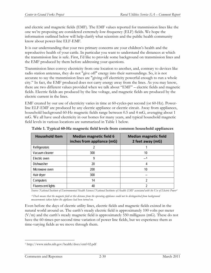
Center to Grand Forks Project Rural Utilities Service EA – Comment Report
Comments and Reponses 2-30 March 2011
and electric and magnetic fields (EMF). The EMF values reported for transmission lines like the one we’re proposing are considered extremely-low-frequency (ELF) fields. We hope the information outlined below will help clarify what scientists and the public health community know about power-line ELF-EMF.
It is our understanding that your two primary concerns are your children’s health and the reproductive health of your cattle. In particular you want to understand the distances at which the transmission line is safe. First, I’d like to provide some background on transmission lines and the EMF produced by them before addressing your questions.
Transmission lines convey electricity from one location to another, and, contrary to devices like radio station antennas, they do not "give off" energy into their surroundings. So, it is not accurate to say the transmission lines are "giving off electricity powerful enough to run a whole city.” In fact, the EMF produced does not carry energy away from the lines. As you may know, there are two different values provided when we talk about “EMF” – electric fields and magnetic fields. Electric fields are produced by the line voltage, and magnetic fields are produced by the electric current in the lines.
EMF created by our use of electricity varies in time at 60-cycles-per second (or 60-Hz). Power-line ELF-EMF are produced by any electric appliance or electric circuit. Away from appliances, household background 60-Hz magnetic fields range between 0.5 and 4 mG, averaging about 1 mG. We all have used electricity in our homes for many years, and typical household magnetic field levels in various locations are summarized in Table 1 below.
Table 1. Typical 60-Hz magnetic field levels from common household appliances
Household Item Median magnetic field 6 inches from appliance (mG)
Median magnetic field 2 feet away (mG)
Refrigerators 2 1 Vacuum cleaner 300 10 Electric oven 9 -- A Dishwasher 20 4 Microwave oven 200 10 Hair dryer 300 -- Computers 14 2 Fluorescent lights 40 2
Source: National Institute of Environmental Health Sciences/National Institutes of Health: EMF associated with the Use of Electric Power1
A Dash means that the magnetic field at this distance from the operating appliance could not be distinguished from background measurements taken before the appliance had been turned on.
Even before the days of electric utility lines, electric fields and magnetic fields existed in the natural world around us. The earth’s steady electric field is approximately 100 volts per meter (V/m) and the earth’s steady magnetic field is approximately 550 milligauss (mG). These do not have the 60-times-per-second time variation of power line fields, but we experience them as time-varying fields as we move through them.
1 http://www.niehs.nih.gov/health/docs/emf-02.pdf
Rural Utilities Service EA – Comment Report Center to Grand Forks Project
March 2011 2-31 Comments and Responses
There has been much public debate and research regarding ELF-EMF for over 35 years, triggered by weak and inconsistent statistical correlations between living in proximity to utility distribution systems and childhood leukemia cases. However, such correlations are unable to make a cause-and-effect link, and they have not been supported by other lines of scientific investigation. In the President’s Cancer Panel 2008-2009 Annual Report (published in April 2010),2 the weaknesses of the childhood-leukemia epidemiologic associations in the studies were discussed: (1) EMF were not measured, but distance to power lines was used to estimate exposures inside of a home (2) all sources of EMF were not considered, and (3) the selection of cases and controls was likely biased. Also, in November of 2010 the International Commission on Non-Ionizing Radiation Protection (ICNIRP) released an update to their 1998 guidelines on public exposures to EMF. They reviewed the scientific evidence relating to ELF-EMF health effects and concluded that the evidence “is too weak to form the basis for exposure guidelines.” 3
Considerable ELF-EMF laboratory research has been conducted on how electric and magnetic fields interact with biological systems and the "physics" is well understood.
4
Table 1 illustrated that by moving an additional foot or so away from the source of the magnetic fields that the values decrease significantly. This is true for all sources of EMF, such as the transmission lines we build. Minnkota has performed analyses of the calculated EMF levels for this project. Our results are shown below in Table 2, and you may notice that the magnetic field values also drop off with distance. The phrase “On ROW” refers to the location directly under the transmission line and the phrase “Edge ROW” refers to a distance 75 feet from directly underneath the transmission line. Table 2 also shows how the calculated levels at any location within the proposed right of way (ROW) are below the International Commission on Non-Ionizing Radiation Protection’s (ICNIRP) widely referenced guidelines (2,000 mG and 4.2 kV/m) for public exposure to EMF. There are no public health agencies, such as the North Dakota Department of Health, that have set guidelines that set any restriction on how close a person can be to an overhead power line right of way.
Because electric fields are blocked by ordinary substances that conduct electricity such as skin, foliage, and house structures, magnetic fields have been the focus of most of the research regarding possible health effects to both humans and livestock. To date, the numerous studies completed have consistently shown that even elevated levels of power line magnetic fields cannot trigger adverse biological changes in the cells in our body. Numerous experiments where animals were exposed to high levels of magnetic fields over a lifetime showed a lack of any changes in normal biological function. Additionally, scientists haven’t been able to identify a mechanism whereby ELF-EMF can cause mutations or molecular changes in an organism. Moreover, numerous scientific studies have tried, but have been unable, to demonstrate that power-line magnetic fields can cause cancer to develop in animals or in isolated cells.
2 http://deainfo.nci.nih.gov/ADVISORY/pcp/annualReports/pcp08-09rpt/PCP_Report_08-09_508.pdf. 3 ICNIRP. 2010. Fact Sheet on the Guidelines for Limiting Exposure to Time-Varying Electric and Magnetic Fields (1Hz-100 kHz). Published in Health Phys 99(6): 818-836: 2010. 4 Council on the American Physical Society. State on Power-lines and Public Health.

Center to Grand Forks Project Rural Utilities Service EA – Comment Report
Comments and Reponses 2-32 March 2011
Table 2. Preliminary Calculated EMF Levels for the Project
Project Load Condition Electric Field (kV/m) Magnetic Field (mG)
On ROW Edge ROW On ROW Edge ROW
Normal Operating Condition 2.4 1.2 70 42 Maximum Operating Condition 3.7 1.2 277 93
a Normal Operating Condition was assumed to be 404 MVA for winter-normal at maximum allowable voltage. b Maximum Operating Condition was assumed to be the thermal limit based on capacity of the conductor at maximum allowable voltage.
Several scientific organizations including the American Medical Association5, American Cancer Society6, American Physical Society7, and National Academy of Sciences8
• The epidemiology studies on EMF do not utilize actual EMF exposures and show weak and generally inconsistent correlations between estimates of EMF exposure and health statistics.7
have stated that the body of evidence in regard to ELF-EMF, particularly magnetic fields, indicates that exposure to these fields do not present a human health hazard. Minnkota trusts the large number of credible, scientific organizations that have all come to the same conclusions about ELF-EMF and public health:
• Laboratory research has not been able to establish either cause and effect relationship between exposure to magnetic fields and any human disease, or a plausible biophysical or biological mechanism by which exposure to EMF could cause disease.8
• The magnetic fields produced by electricity do not have the energy necessary to break chemical bonds and cause DNA mutations. 9
In summary, many public health agencies (e.g. American Cancer Society, Environmental Protection Agency, Food and Drug Administration, Centers for Disease Control) have not set power line EMF exposure guidelines because they have not found the scientific studies sufficiently supportive of the need for a numerical EMF exposure guideline or a "safe distance" criterion. Overhead transmission line rights-of-way exist all around the country and around the
5 Effects of Electric and Magnetic Fields. 1994. Report of the American Medical Association (AMA), Council on Scientific Affairs. Chicago: AMA (December 1994). http://www.ama-assn.org/ama/no-index/about-ama/13682.shtml. 6 Electromagnetic field exposure and cancer: a review of epidemiologic evidence. 1996. Report of the American Cancer Society, by Heath, C.W., CA Cancer Journal for Clinicians 46: 29-44. http://caonline.amcancersoc.org/cgi/content/abstract/46/1/29. 7 Electric and Magnetic Fields and Public Health. 2005. American Physical Society. National Policy 05.3, Adopted April 15, 2005). http://www.aps.org/policy/statements/05_3.cfm. 8 Possible Health Effects of Exposure to Residential Electric and Magnetic Fields. 1997. Report of the National Research Council, Committee on the Possible Effects of Electromagnetic Fields on Biologic Systems. Washington: National Academy Press. http://www.nap.edu/openbook.php?isbn=0309054478. 9 Valberg, Peter A. 2009. Power-Line Electric and Magnetic Fields (EMF): Status of Scientific Research on Potential Health Effects, Gradient Corporation for CapX2020.
Rural Utilities Service EA – Comment Report Center to Grand Forks Project
March 2011 2-33 Comments and Responses
world, and no legitimate public health agency has proposed that an "unsafe" region exists in the proximity of these lines.
The second issue that you expressed concerns about was the effects of EMF on the reproductive health of your cattle. It is first important to note that the vast amount of laboratory animal research focused on EMF effects on living organisms has not demonstrated that power line magnetic fields affect reproductive function. With respect to cattle, specifically, a considerable amount of research on EMF and livestock (particularly cows) has been conducted in Quebec, Canada. A recent joint study conducted by McGill University, Ministere de l'Agriculture, des Pecheries et de l'Alimentation du Quebec (MAPAQ) and the Quebec Dairy Committee where cows were exposed to high levels of EMF did not show any changes in the hormonal profile and dairy production of Holstein cows10
10
. This, in addition to several other studies conducted since the 1970s, indicate that no biological disorder can be attributed to the exposure of livestock to EMF generated by high-voltage transmission lines. Additionally, no harmful effects on the health, productivity, fertility, reproduction, or behavior of livestock exposed to EMFs have been observed and power line EMF exposures are not anticipated to be harmful to farm animals.
In addition, Minnkota, and other utilities in agricultural regions of the country, have operated 345 kV systems for many years. Through the years, we have never received a statement concerning the potential adverse effects of the 345 kV power system on cattle. As a result, we anticipate no impact from the project (new 345-kV line) on your cattle’s reproductive health or fertility.
Sometimes, EMF are confused with “stray voltage.” "Stray voltage" is typically caused by wiring and electrical connections on the farm associated with the wires that come from the distribution system to your farm (i.e., the smaller, lower-voltage electric line that brings power from utility substations to your house, barn, and other farm buildings) and not the high-voltage transmission line (i.e., the electric line that brings power from the generation source to substations and hence to the distribution system). Stray voltage is an accidental difference in electrical potential between two objects. For example, if a cow touches a poorly grounded metal object in a building with her nose and is standing on a damp floor, and if the metal object and the floor have different electrical potentials, then a weak electric current will pass through the cow’s body. This current, if strong enough for the animal to feel, may cause some discomfort. A good resource on stray voltage issues is the USDA Agricultural Handbook (#696): Effects of electrical voltage/current on animals: how to detect and remedy problems (1991). In summary, stray voltage is not a problem associated with high-voltage transmission lines, but rather an issue with electrical wiring and grounding practices within a farm or home, and it can generally be minimized through good grounding practices.
10 HydroQuebec. 1999. Effects of Electric and Magnetic Fields on Livestock Health and Productivity. Published for TransEnergie by the Vice-presidence Affaires corporatives et secretariat general. http://www.hydroquebec.com/sustainable-development/documentation/pdf/cem/pop_24_01.pdf.
Center to Grand Forks Project Rural Utilities Service EA – Comment Report
Comments and Reponses 2-34 March 2011
COMMENT #: 347 COMENT SOURCE: EMAIL
John Schockley
Good afternoon, I have been asked by several landowners, who are also farmers, to submit the following two questions regarding the above described project: (1) Will the proposed 345 KV power line create electromagnetic fields that will interrupt their GPS and other precision framing equipment which relies upon satellite to provide data to their equipment to regulate the application of seed, fertilizer and other inputs and data collections? If so, what types of mitigation efforts will Minnkota undertake to minimize these effects? (2) Has Minnkota made any efforts to locate the proposed route on publicly owned lands so as to minimize the impact to private landowners. If not, what is the rational for not locating the route on publicly owned lands? I apologize if these comments are late, however, the landowners have just started to become aware of the ongoing process and just recently contact me. Will there be other opportunities to comment on the proposed route?
Comment:
EA Reference
Section 2.4.1, Section 3.2, Section 5.0
:
GPS navigation systems are becoming more common on farm equipment. GPS units collect location data from at least three or more satellites at any given time. The accuracy of the location data is dependent on the number of satellites and the strength of the signal. Since satellites are in constant motion above the earth, GPS units are constantly picking up and dropping satellites. At times there might be instances when the GPS unit is not able to connect to enough satellites and the required accuracy is not met.
Response:
In 2002 the Institute of Electrical and Electronics Engineers (IEEE) published a study that investigated the effects of overhead power lines on GPS receivers with respect to the effects of EMI (electromagnetic interference) and found that it is unlikely that power line conductors interfere with the use of GPS signals.
John Deere Company manufactures precision farming equipment with two levels of operation – 1) subscription and 2) non-subscription. Subscription operation is where the farm equipment receives data from base stations that are spaced about 18 miles apart and satellites. Non-subscription operation utilizes only satellites. John Deere states that most decreases in GPS accuracy is due to satellite position, not transmission lines.
On rare occasions, a transmission line structure may cause a temporary drop in accuracy due to blocking a view to one satellite, but this would only occur if the receiver, structure, and satellite are in a line, which is rare. Connection is usually restored within minutes and the GPS units return to normal function.
Minnkota has operated a similar 345 kV transmission line and no comments have been received regarding issues with precision farming technology in relation to the transmission line.
Following construction, Minnkota may provide GPS coordinates for the transmission line structures to landowners, if requested.
Many types of federal and state land fall under the North Dakota Public Service Commission’s Exclusion and Avoidance Criteria, as set forth in NDAC Section 69-06-08-02. The PSC states
Rural Utilities Service EA – Comment Report Center to Grand Forks Project
March 2011 2-35 Comments and Responses
that Exclusion areas should be excluded in the consideration of a route for a transmission facility. An Avoidance area shall not be considered in the routing of a transmission facility unless there is no reasonable alternative. Minnkota utilized the PSC’s Criteria to develop the routes presented in the EA. Currently, Minnkota has entered into the PSC’s Certificate of Corridor Compatibility and Route Permit Application processes, and this comment will be considered for the PSC Applications.
Minnkota has an extensive public outreach program for this Project to create opportunities for the public to receive proposed Project information in a timely manner, listen to community concerns, and work with the public to develop proposed Project solutions. Minnkota worked to develop open communication. The following bullets outline public meetings throughout the proposed Project development:
• May 2009 – Project announcement and data gathering open house meetings held in Washburn, Wing, Carrington, Cooperstown, and Grand Forks, North Dakota
• August 2009 – Additional open house meeting per public’s request held in Center, North Dakota.
• November 2009 – RUS Scoping Meetings held in Center, Wilton, McClusky, Carrington, Cooperstown, and Grand Forks, North Dakota
• April 2010 – Presentation and route segment review open house meetings held in Center, Wilton, McClusky, Carrington, Finley, and Grand Forks, North Dakota.
In addition, Minnkota sent landowner notification letters for each round of meetings, published paid advertisements in local newspapers, and provides current information on the proposed Project website and toll-free hotline.
Future opportunities to comment on this Project will be during the Public Hearings which are anticipated for Spring 2011 and lead by the North Dakota Public Service Commission (PSC) as part of the PSC process as Minnkota applies for a Certificate of Corridor Compatibility, followed by a Route Permit application.
Minnkota welcomes comments at any time during the development of the Center to Grand Forks Project. The Project Website (www.minnkotacgf.com) allows for anyone to leave a comment or join the mailing list on the “contact us” page. In addition, a toll-free proposed Project information line (800-473-5679) has been established to provide a proposed Project status update, opportunity to leave a comment, and join the proposed Project mailing list feature.
COMMENT #: 348 COMMENT SOURCE: LETTER
Jeremy Bushee
Same letter as comment #325
Comment:
EA Reference
Section 2.0, Appendix B, page 53 of 55
:
See response to Comment #323.
Response:

Center to Grand Forks Project Rural Utilities Service EA – Comment Report
Comments and Reponses 2-36 March 2011
COMMENT #: 349 COMMENT SOURCE: LETTER
Jesse Hanson – North Dakota Parks and Recreation Department
This letter is in response to the USDA Rural Utilities Service's (RUS) request for comments on the EA for the above referenced project. ND Parks and Recreation Department (Department) will reiterate and expand on comments previously stated in a letters to Michael Hennes, Minnkota Power Cooperative, Inc. dated May 26, 2009 and to you on December 14, 2009. In those letters we raised numerous concerns about the project and its proximity to Cross Ranch State Park and Nature Preserve. If the Preferred Route - Alternative A is chosen many of those comments will be irrelevant. The Department with some reservations, supports the Preferred Alternative Route - Route A as the most environmental preferable of the three alternatives.
Comment:
Nature Preserves: Proposed Route C of the project, in particular the portion that passes through Oliver County includes properties that contain significant natural, historic, scenic and cultural resources. Cross Ranch Nature Preserve owned by The Nature Conservancy and Cross Ranch State Park are areas of concern and must be avoided. These tracts, owned and managed by either the ND Parks and Recreation and The Nature Conservancy are dedicated state nature preserves under ND Century Code chapter 55-11. Protective covenants in chapter 55-11 direct uses of these properties. The protective covenants applied by ND C.C. prohibits intrusions on the nature preserve properties such as power transmission line. The Preferred Route - Route A would avoid these lands.
River Crossing: Route transmission lines to avoid areas considered scenic such as state parks, nature preserves, recreational areas, and wildlife management areas. Avoid placement of the poles on river banks to reduce visual impacts of river recreational users. We strongly recommend limiting the river crossings within an already existing impact corridor. Impacts of river crossings should include public values of limiting visual and scenic impacts on the river. Keeping the proposed transmission line within the already impacted area will reduce the overall scenic/aesthetic impacts from the perspective of the river. It appears that Route A would fall within an already impacted area along the Missouri River.
Ecological Communities: River Bottomland forests provide recreational opportunities and wildlife and plant habitat. Avoid routes that fragment large forest blocks. Forest fragmentation can cause permanent reduction in species diversity and suitable habitat. All 4 proposed "Potential Crossings" involve impacts to forested river bottomland. Route A appears to impact the least amount of vulnerable terrestrial communities. We support the RUS efforts to mitigate impacts to woodlands using a 2:1 replacement ratio but would like to see reference made to native woodland species appropriate for the local habitat.
Wildlife: We have concerns with how the project will affect native species, particularly bald eagles nesting along the river adjacent to project area. As bald eagles are sensitive to disturbances, we recommend that the Corps perform all work outside of the active nesting period (February - August 15). In addition, we suggest that if construction is performed during bald eagle nesting season that it be conducted at least .5 miles away from and outside of the line-of-sight of any active bald eagle nests.
Visual Resources: Specific to the scenic Missouri River, all efforts to minimize the visual effects of the transmission line need to be implemented. Route A and B appear to fall within an already disturbed area whereas, Route C does not. What is the maximum feasible distance or intent of
Rural Utilities Service EA – Comment Report Center to Grand Forks Project
March 2011 2-37 Comments and Responses
setback for monopoles specifically along the Missouri River crossing? To the greatest extent possible, RUS must utilize self-weathering monopoles and maximize the setback to minimize the impacts on the scenic qualities of the Missouri River.
Recreational Resources: The Preferred Route - Route A would not potentially impact Cross Ranch State Park or Nature Preserve. Whereas, Route C would have the greatest potential to produce adverse impacts to these areas.
In closing we support the RUS Preferred Route - Route A but with some reservations. It is not clear as to potential impact to Cross Ranch area if Route A is chosen when one reads the two sentences on Page 4-1 stating "As Minnkota negotiates easements and enters into the state permitting process there could be variations within the final route alignment. However, the final alignment would be located within the macro-corridors.” Thank you for the opportunity to once again provide comment on this project.
EA Reference
Section 2.4, Section 3.4.3, Section 3.15, Section 4.0
:
As stated in the Environmental Assessment, Route A is the preferred route. Minnkota will continue to update their Project website with the most current routing maps (www.minnkotacgf.com). Minnkota will continue to consult with the North Dakota Parks and Recreation Department through Project development.
Response:
Nature Preserves: Minnkota considered the location of the nature preserves (Cross Ranch Nature Preserved, Cross Ranch State Park) during routing and avoided nature preserves during routing.
River Crossing: As stated in Environmental Assessment, Route A would cross the Missouri River about 1.25 miles north of the existing high-voltage direct current transmission line. The route has been modified after additional review to have the proposed Missouri River crossing closer to the existing high-voltage direct current transmission line, which would reduce the visual affect of a new river crossing to river users.
Ecological Communities: As described in Section 3.4.3, Minnkota would mitigate impacts to woodland areas using a 2:1 replacement ratio (based on the number of trees removed), per North Dakota Public Service Commission (PSC) requirements. If feasible, the replacement areas would be located in the vicinity of the impacts. Where functional woodlands would be removed (such as shelter belts), mitigation would be designed to replace the intended utility of the impacted woodland. Impacts to impaired and vulnerable terrestrial communities would be minimized as described in the Environmental Assessment Section 3.4 and BMPs would be used to minimize the spread of non-native species.
Wildlife: Aerial surveys for raptor nests were conducted in March 2010. No bald eagle nests were located at the potential crossing areas. Minnkota will construct the Missouri River crossing after August to minimize potential impacts to avian resources.
Visual Resources: The transmission line structures would span Missouri River, with structures being placed about 150 feet away (back) from river’s edge. Currently, Minnkota is assessing structures that may be used to span the Missouri River. If a steel structure is used, Minnkota may consider a self-weathering structure. The self-weathering steel oxidizes or rusts to form a dark reddish brown surface coating to protect the structure from further weathering. The reddish brown color would be a neutral color to reduce visual impacts.
Center to Grand Forks Project Rural Utilities Service EA – Comment Report
Comments and Reponses 2-38 March 2011
Recreational Resources: Minnkota considered the locations of recreational opportunities during route development. Route A is the preferred route according to the Environmental Assessment that would not affect the Cross Ranch State Park.
COMMENT #: 350 COMMENT SOURCE: LETTER
Allen Jorde
Same letter as Comment #325.
Comment:
EA Reference
Section 2.0, Appendix B, page 53 of 55
:
See response to Comment #323.
Response:
COMMENT #: 351 COMMENT SOURCE: LETTER
Jean Johnson
I'm sorry to say I did sign those papers for the towers, but I wish I had not. Especially after finding out what was being paid for the wind towers. The amount being paid and the duration of the payments. I think you had better be making a better deal with the farmers. The land you are taking out of production for all time and what about the land that will not be in use while the towers are being installed? The land I signed for is being rented out, how can I expect the renters to pay the same rent when so much will not be productive? Come on - we need a better deal. Better yet go on someone else's land.
Comment:
Section 1.5.3
EA Reference:
The easement and right-of-way acquisition process is outlined in Section 1.5.3. Please contact the Minnkota land agent for direct questions regarding compensation.
Response:
COMMENT #: 352 COMMENT SOURCE: LETTER
Tracy Bailey
Same letter as Comment #325.
Comment:
EA Reference
Section 2.0, Appendix B, page 53 of 55
:
Same letter as Comment #323.
Response:
Rural Utilities Service EA – Comment Report Center to Grand Forks Project
March 2011 2-39 Comments and Responses
COMMENT #: 353 COMMENT SOURCE: LETTER
Jim and Terri Heron
We received a card dated November 16, 2010, inviting any comments on the environmental issues on the Center to Grand Forks Transmission Line Project. These are our concerns with the possible alternate route that would run within one half mile of the Robert L. Morgan Waterfowl Refuge in Cathay Township, County of Wells. The acreage where this alternate proposed route would cross is invariably covered with nesting and feeding waterfowl in their migratory flights. Tens of thousands of birds use that area. Should this route ever be utilized, it would necessitate negotiation of towers and lines by huge numbers of birds, flying in vast flocks, in daylight and darkness, over an extended number of days. Not merely passing through, but stopping to rest and feed also. This refuge was just recently created, its cost, in the millions of dollars, its purpose, to maintain and propagate waterfowl. To even consider construction of such an obstacle so near to this refuge, seems extremely counter productive and very environmentally unsound. Undoing what millions of dollars were spent to preserve and protect. Why devote approximately 1500 acres to waterfowl protection and then sabotage the birds that use it by erecting structures so potentially destructive to their well-being, a scant 2500 feet from the refuge. Common sense tells us this would a very bad combination with a costly outcome.
Comment:
EA Reference
Section 3.5, Section 3.6, Appendix B
:
Appendix B of the Environmental Assessment contains detailed route maps of Route A, B, C, and all segment route alternatives reviewed. The Robert L. Morgan Wildlife Management Area (WMA) - Route A (SO26) is 6.9 miles north of the WMA. Route C (SO31) is 0.4 miles north of the WMA. Route B (SO28) is 3.4 miles south of the WMA. Route A is the preferred route. No impacts to the WMA are anticipated. Environmental Assessment Sections 3.5 and 3.6 discuss impacts to wildlife and mitigation measures Minnkota would implement to reduce wildlife and avian impacts. Minnkota would use the following minimization measures to address avian issues associated with the transmission line:
Response:
• Consultation with the USFWS and RUS would continue to identify areas where both of the transmission line shield wires would be considered for marking in an alternating pattern. As noted in Section 3.6, both of the shield wires would be marked in an alternating pattern to mitigate for sections of routes near suitable whooping crane habitat within the whooping crane migration corridor.
• The transmission line would be designed with consideration of the guidance found in Avian Power Line Interaction Committee’s (APLIC) Suggested Practices for Avian Protection on Power Lines: The State of the Art in 2006.
• To discourage active nesting within parts of the ROW expected to be temporarily or permanently disturbed by the proposed Project, tree removal, ground clearing, or mowing would occur in late fall or early spring to discourage tree and ground nesting.
• If the ROW is not cleared in early spring before the breeding season, a qualified biologist would survey the construction ROW for active ground nests and provide a construction buffer.

Center to Grand Forks Project Rural Utilities Service EA – Comment Report
Comments and Reponses 2-40 March 2011
COMMENT #: 354 COMMENT SOURCE: LETTER
Chad Sherod
Same letter as Comment #325.
Comment:
EA Reference
Section 2.0, Appendix B, page 53 of 55
:
See response to Comment #323.
Response:
COMMENT #: 355 COMMENT SOURCE: LETTER
Jim Thompson
This letter is written to express my views and comments on the proposed transmission line proposed to traverse Griggs County, North Dakota. Route A and C, a northern route, would follow the east-west section line along the southern edge of Section 31, T148N, and R58W. This route would cross the Sheyenne River bottom land that has been owned by my family for generations. I am opposed to this route. Siting a linear utility is never an easy undertaking. I know the situation well from a project proponent's perspective, as I have worked in the oil and gas industry for over 30 years and have been responsible for developing routes and underground pipelines. It is difficult to balance the concerns of land owners who usually will get no benefit from the utility service being provided, the responsibilities of environmental protection and stewardship of the land, and the wishes of the company proposing the project. As with pipeline projects, I am sure that constructability ($) and long-term maintenance ($) are also issues to address for power transmission lines. With these issues in mind I am surprised that that route segment is being proposed. I can only assume that the owner company wants the shortest, least costly route to construct and is not considering long term maintenance issues, environmental damage and lost wildlife habitat, and the landowner concerns. Instead of following an existing transportation corridor, and there are several nearby, the route crosses prime farmland and undisturbed riparian habitat, with old growth river bottom forest. Depending on the route, the location of towers will destroy prime productive farmland and make farming and maneuvering farm equipment more difficult. The corridor itself will undoubtedly result in the removal of timber and riparian vegetation that is essential for maintaining wildlife habitat and river bank stability. As a result, it is very likely that bank erosion will increase and that will lead to loss of important habitat and possibly farmland. The Sheyenne River Valley of central and eastern North Dakota is a beautiful broad valley with wooded draws along the upper valley sides leading down onto a broad flood plain. Much of the bottom land is highly productive farmland and the river meanders and twists along its way through the valley. The combination of land use types and connection of the uplands with the river bottom makes this region one of the richest wildlife habitats in the Northern Great Plains. Native Americans historically lived in this area and you can find cultural resource evidence scattered throughout the hills. It is a beautiful, peaceful place and I have often sat on one of our hilltops looking down enjoying the view of the valley. I just cannot imagine a string of ugly, gray steel towers plopped in the middle of our farmland and cutting a diagonal across the river bottom and hill sides. Perhaps the hum and
Comment:
Rural Utilities Service EA – Comment Report Center to Grand Forks Project
March 2011 2-41 Comments and Responses
crackle of the overhead power cables will take my mind off the visual sight before me? I am not saying that the power transmission lines should not be built. We need the power and enjoy the lifestyle that reliable, cost effective power provides. However, it is not likely that the rural communities and farms of northern Griggs County will benefit from this transmission line. It is important, therefore, that you consider and address the concerns of the landowners in the area. There are other options that would place the line in existing corridors; this makes much more sense than destroying more land for yet another power line.
Select a route that follows an existing highway, which is already established as a transportation corridor. That's why they are there and one of their purposes, so let's use them. Does every construction opportunity have to create a new corridor on undisturbed land? This is very poor land use and should not be acceptable practice today. Specifically, my concerns for the A and C Routes are: permanent destruction and loss of prime farmland in the Sheyenne River Valley. Destruction of native riparian habitat, native hardwood river bottom forests, river wildlife habitat. It is not clear how or where the hardwood forests and other vegetation would be replaced? I am assuming you will replace the trees that would be destroyed. Would you take yet more farmland for replanting trees and shrubs? Destruction of upland habitats, native grasslands, native shrub lands. Deaths of migratory birds, ducks, and waterfowl, eagles and other raptors, that strike the power lines. Loss of wildlife due to outward migration during construction and after construction due to loss of habitat. Soil erosion during and after construction on steep slopes. River bank instability and erosion due to clearing of trees and vegetation. River bank instability and collapsing could lead to increased farmland flooding.
Wetland losses. Destruction of the natural beauty and pristine nature of this part of the valley. Impair and destroy the visual sight lines in the valley and our land. Mr. Rankin, we are opposed to the A and C Routes proposed for this project. I thank you for considering our concerns and request that you select a route that utilizes existing transpiration corridors, minimizes environmental damage, and addresses individual landowners' concerns.
EA Reference
Section 2.4, Section 3.2, Section 3.3, Section 3.5, Section 3.6, Section 3.8, Section 3.11, Section 3.12, Section 4.0, Appendix B
:
Appendix B contains detailed route maps of Route A, B, C, and all segment route alternatives reviewed. According to the Environmental Assessment, Route A is the preferred route that follows the southern edge of Section 31, T148N, and R58W. Minnkota will continue to update their Project website with the most current routing maps (www.minnkotacgf.com). Please continue to check this website for route modifications.
Response:
Minnkota utilized the following criteria to identify routes and segment alternatives (see Section 2.4.1 in the Environmental Assessment):
• Follow existing rights-of-way, survey lines, natural division lines, and agricultural field boundaries when feasible
• Minimize length • Avoid populated areas where feasible • Avoid major environmental features where feasible • Avoid known historic and cultural resources areas, where feasible
Center to Grand Forks Project Rural Utilities Service EA – Comment Report
Comments and Reponses 2-42 March 2011
• Maximize transmission system reliability and promote system redundancy where feasible • Avoid agricultural production • Avoid airports and other conflicting land uses • North Dakota Public Service Commission Exclusion and Avoidance Criteria
Mitigation of impacts to agricultural vegetation is addressed in Section 3.2.3. Impacts to prime farmland and corresponding mitigation measures and best management practices are discussed in Section 3.3 of the Environmental Assessment. Section 3.4 of the Environmental Assessment discusses impacts to habitat and vegetation and corresponding mitigation measures. Minnkota would mitigate impacts to woodland areas using a 2:1 replacement ratio (based on the number of trees removed), per PSC requirements. Environmental Assessment Sections 3.5 and 3.6 discuss impacts to wildlife and mitigation measures Minnkota is implementing to reduce wildlife and avian impacts. Wetland impacts and mitigation are discussed in Section 3.8. Mitigation methods for visual impacts are discussed in Section 3.11. Section 3.12 addresses noise impacts and mitigation.
As discussed in Section 3.10 of the Environmental Assessment, federal legislation and executive orders require consideration of the cultural and historical environment by federal agencies. In particular, the National Historic Preservation Act of 1966, as amended ((NHPA)(16 U.S.C. § 470 et seq.)), requires federal agencies to take into account the effect their actions may have on historic properties and consult on those effects with interested parties prior to carrying out such actions. Rural Utilities Service (RUS) is coordinating compliance between the National Historic Preservation Act (NHPA) Section 106 procedures and the steps taken to meet National Environmental Policy Act (NEPA) requirements. Minnkota began to elicit information from tribal governments and Tribal Historic Preservation Offices (THPOs) early in the proposed Project planning process. The efforts of Minnkota and RUS to consult with the interested tribes are outlined in Section 5.3 of the Environmental Assessment. Additionally, Minnkota and its consultant reviewed records sent from the State Historic Preservation Office (SHPO) to identify known archaeological resources within one mile of the centerline of the route and segment alternatives. Pedestrian surveys of the preferred route in selected areas began in Fall 2010 and when a route centerline is selected additional surveys for architectural and archaeological resources will occur. Minnkota is committed to identifying and avoiding impacts to additional resources that may be within the route that have not yet been recorded. Physical avoidance of resources will be a consideration in locating the final route. However, any resource that cannot be avoided will be treated according to the stipulations outlined in the Programmatic Agreement (PA) between RUS, SHPO, and other interested parties.
COMMENT #: 356 COMMENT SOURCE: LETTER
Jerome Schaar - USDA-Natural Resources Conservation Services
The Natural Resources Conservation Service (NRCS) has reviewed your letter dated November 9, 2010, concerning a proposed Center to Grand Forks 345-kV Transmission Line Project. NRCS has a major responsibility with Farmland Protection Policy Act (FPPA) in documenting conversion of farmland (i.e., prime, statewide, and local importance) to non-agricultural use when federal funding is used. Your proposed project consists of activities that are subject to FPPA. New transmission towers may remove farmland from production; therefore, those sites may be subject to FPPA, and the Form AD-106 must be completed. Activities that do not enact
Comment:

Rural Utilities Service EA – Comment Report Center to Grand Forks Project
March 2011 2-43 Comments and Responses
FPPA include the burying of electrical lines or activities within city limits. Below are instructions for completing the AD-106 for those areas affected by FPPA provided that federal funds are being used. Important Farmlands - For those subject to FPPA, the following form must be completed. Enclosed is Form AD-1006 or you may utilize a fillable, web based form. Please complete Part I and Part III. We will also need a map of the site at an appropriate scale so we can accurately assess the area (e.g., 1:20,000 or 1:24,000). If the farmland (i.e., prime, statewide, and local importance) is determined to be subject to FPPA, we will then complete Parts II and IV. NRCS will measure the relative value of the site as farmland on a scale of 0 to 100, according to the information sources listed in CFR, Sec. 658.5(a). If FPPA applies to this site, Form AD-1006 will be returned to your agency for completion of Part VI, Site Assessment Criteria. Wetlands - The Wetland Conservation Provisions of the 1985 Food Security Act, as amended provide that if a USDA participant converts a wetland for the purpose of, or to have the effect of, making agricultural production possible, loss of USDA benefits could occur. You are anticipating construction outside of the right-of-way where wetland impacts may occur that could make production possible. NRCS has developed the following guidelines to help avoid impacts to wetlands and possible loss of USDA benefits for producers. If these guidelines are followed, the impacts to the wetland(s) will be considered minimal allowing USDA participants to continue to receive USDA benefits. Following are the requirements: 1) Disturbance to the wetland(s) must be temporary, 2) no drainage of the wetland(s) is allowed (temporary or permanent), 3) mechanized landscaping necessary for installation is kept to a minimum and preconstruction contours are maintained, 4) temporary side cast material must be placed in such a manner not to be dispersed in the wetland, and 5) all trenches must be backfilled to the original wetland bottom elevation. NRCS would recommend that impacts to the wetlands be avoided. If the alignment of the project requires passage through a wetland, NRCS can complete a certified wetland determination, if requested by the landowner/operator.
EA Reference
Section 3.2, Section 3.3, Section 3.8, Appendix B, Section 6.0
:
As stated in the Environmental Assessment, Route A is the preferred route. Addressed in Section 3.2.2 and Section 6.0, Minnkota would work with the local NRCS office and landowners to determine the location of CRP parcels and to avoid or minimize impacts under FPPA. If necessary, Form AD-1006 would be completed for the Project. Minnkota would continue to consult with the NRCS during Project development. Minnkota avoid impacts to wetlands to the extent practical. As stated in Section 3.8 of the Environmental Assessment, Minnkota would use BMPs during construction and operation of the transmission line and associated facilities to protect topsoil and adjacent wetland resources and to minimize soil erosion. Practices may include containing excavated material, protecting exposed soil, stabilizing restored material, and revegetating disturbed areas with native species.
Response:
COMMENT #: 357 COMMENT SOURCE: LETTER
Douglas Handt
I reviewed the whole thing; A) the concern of the Ojibwe tribe on the James River is not just that tribe but all tribes concerned as the James River was part of the Native American route. I'm not Native American but, I still know. B) the cement pyramids have to be at least 20 ft. from
Comment:

Center to Grand Forks Project Rural Utilities Service EA – Comment Report
Comments and Reponses 2-44 March 2011
underground pipelines which this transmission line would be in checkmate in some zones in the state of ND. C) then you have the rural water supplies which aren't to deep but may have to be diverted around. D) as far as economics it would help zones community revenue grow and employment get better. E) as far as underground goes that isn't a good idea because of the rapid change in the ground and deterioration rate of the cables. F) as far as telecommunications cables go you're pretty much in the clear except for certain designated areas as you know. I can't write it for security purposes and I know the owners of the fiber telecommunications operations etc. Good luck in your final decision on this project it would be a pretty good thing for the communities as far as laborers needed etc. Our Industrial Park still has a spot open where you could house materials etc. Also, ND has some of the best security officers.
EA Reference
Section 1.5, Section 2.2, Section 3.13, Section 3.14, Section 5.3
:
A. Minnkota and the Rural Utilities Service have consulted with Native American tribes to evaluate the potential impacts of the proposed Project. It is anticipated that the final route would avoid cultural resource sites and cultural resource sites would be treated in accordance with the Programmatic Agreement, as developed by the Rural Utilities Service.
Response:
B. As described in Section 1.5.1 of the Environmental Assessment, Final design and geotechnical investigations may warrant the use of special structures [and foundations] to avoid sensitive areas, comply with reasonable landowner desires, or accommodate special engineering circumstances [such as underground pipeline locations].
C. Section 3.13.2 of the Environmental Assessment indicates there would be no direct or indirect effects to public services with this proposed Project, which includes rural water supplies.
D. Section 3.14.2 of the Environmental Assessment determined that construction activities would provide a seasonal influx of additional dollars into the communities during the construction phase. Long-term beneficial impacts from the proposed Project include increased local tax base resulting from the incremental increases in revenues from transmission lines taxes.
E. Section 2.2.5 of the Environmental Assessment determined an underground transmission line did not meet the identified need as well or at a comparable cost to the Project proposed in the Environmental Assessment.
F. Section 3.13.2 of the Environmental Assessment indicates there would be no direct or indirect effects to public services with this proposed Project, which includes fiber optics.