Cenozoic motion of the Philippine Sea Plate ...searg.rhul.ac.uk/pubs/hall_etal_1995 Philippine Sea...
16
TECTONICS, VOL. 14, NO. 5, PAGES, 1117-1132, OCTOBER 1995 Cenozoicmotion of the Philippine Sea Plate: Palaeomagnetic evidence from eastern Indonesia Robert Hall SEAsia Research Group, Department of Geology, Royal Holloway, London University, Egham, England UnitedKingdom Jason R. Ali Department of Oceanography, Southampton University, Southampton, England, United Kingdom Charles D. Anderson Department of Geological Sciences, University of California, Santa Barbara Abstract. The history of motion of the Philippine Sea Plate is poorly known becauseit is isolated from the oceanic ridge system. Interpretation of palaeomagnetic results from the plate has been controversial because declination data have been obtained only from the eastern margin where subduction-related tectonic processes may have caused local ratherthan plate-wide rotations. New palaeomagnetic data relevant to the problem have been obtained from 34 sites north of the SorongFault and 29 sites within the Sorong Fault system. These sites record south- ward movement during the Eocene and northward movement during the Neogene. Siteswithin the Sorong Fault system record both counterclockwise and clockwise rotations interpreted as the result of Neogene block movements at the southern boundary of the Philippine Sea Plate. North of the Sorong Fault, all sites record clockwise declinations. Neogene rocks have small deflections consistent with rotation about the present-day Eurasia-Philippine Sea Plate pole. Oligocene-middleEocene rocks show consistent clockwise declination deflections of-40 ø . Declinations of lower Eocene rocks indicate -90 ø of clockwise rotation.We propose that the entire area north of the Sorong Faultin east Indonesia hasalways been partof thePhilippine Sea Plate and that the whole plate has rotated clockwise in a discontinuous manner by approximately 90 ø since the early Eocene. The new data from north of the Sorong Fault providea basis for determining rotation poles which satisfy all the palaeomagnetic data from the PhilippineSeaPlate and permitits reconstruction. Introduction The PhilippineSea Plate (Figure 1) has been the source of numerous models associated withsubduction-related processes of plate tectonics. Differentpartsof the plate have beenusedas examples for tectonic processes including initiation of subduction, development of intraoceanic subduction zones, arc rifting, back arc spreading, and forearcextension. There have been two major phases of ocean drilling devoted to Copyright 1995 by the American Geophysical Union. Paper number 95TC01694. 0278-7407/95/95TC-01694510.00 understanding its evolution (Deep Sea Drilling Project (DSDP)/Ocean Drilling Program (ODP) Legs 58, 59, 60, 125, and 126). Despite this,it remains a plate whose Tertiary motion is poorly known. The principal obstacle to deducing the history of motionis the isolationof the PhilippineSea Plate from the global plate circuit since it is surrounded by subduction zones. For this reason its origin and movement history haveremained a source of controversy. It has been suggested [Uyeda and Ben- Avraham, 1972] that the plate was formedwhen subduction of the Pacific Plate was initiated at -45 Ma along transform faults within old Pacific ocean floor, trappingthe former spreading centre in the West PhilippineBasin,and this view has continued to be cited in interpretations of the plate'shistory[e.g., Stem and Bloomer, 1992]. Palaeomagnetism may help provide a solution to the problem. Palaeomagnetic data indicate northwardmovement of the plate although the amount of rotation is less certain. The rotation historyof the plate has a bearing on its origin, on the origin of subduction-related magmatism,and on its movement history, because there are hemisphere ambiguities in palaeolatitudes obtainedfrom inclination data especially for low-latitude sites. Most oceandrilling data lack declination information,and land palaeomagnetic data from the plate remain scarce[Haston and Fuller, 1991]. Although many land studies have reported declination shiftsimplying clockwise rotations, the interpretation of these results hasbeen disputed. All sampling sites have beenat the eastern edge of the plate where local subduction-related tectonicprocesses provide a potentialexplanation for observed rotations [Larson et al., 1975; McCabe and Uyeda, 1983] because several episodes of backarc spreading haveextended the plate's eastern margin since the Eocene. Distinguishinglocal tectonic from plate-wide movements has proved controversial. Haston and Fuller [ 1991] argued that sincethe middle Eocene the Philippine Sea Plate has behaved as a rigid unit with little local tectonic deformation along its eastern margin, rotated continuously clockwise through 90ø- 100 ø, and movednorthward about 15ø-20 ø. Koyama et al. [1992] reviewed tectonic models which could account for their own and older data.They accepted northward motionof the plate but concluded that more data were required to distinguish between models which accountedfor declinationdeflections by rotationof the whole plate and those which attributed part of the deflections to local deformation. 1117
Transcript of Cenozoic motion of the Philippine Sea Plate ...searg.rhul.ac.uk/pubs/hall_etal_1995 Philippine Sea...

TECTONICS, VOL. 14, NO. 5, PAGES, 1117-1132, OCTOBER 1995
Cenozoic motion of the Philippine Sea Plate: Palaeomagnetic evidence from eastern Indonesia
Robert Hall
SE Asia Research Group, Department of Geology, Royal Holloway, London University, Egham, England United Kingdom
Jason R. Ali
Department of Oceanography, Southampton University, Southampton, England, United Kingdom
Charles D. Anderson
Department of Geological Sciences, University of California, Santa Barbara
Abstract. The history of motion of the Philippine Sea Plate is poorly known because it is isolated from the oceanic ridge system. Interpretation of palaeomagnetic results from the plate has been controversial because declination data have been
obtained only from the eastern margin where subduction-related tectonic processes may have caused local rather than plate-wide rotations. New palaeomagnetic data relevant to the problem have been obtained from 34 sites north of the Sorong Fault and 29 sites within the Sorong Fault system. These sites record south- ward movement during the Eocene and northward movement during the Neogene. Sites within the Sorong Fault system record both counterclockwise and clockwise rotations interpreted as the result of Neogene block movements at the southern boundary of the Philippine Sea Plate. North of the Sorong Fault, all sites record clockwise declinations. Neogene rocks have small deflections consistent with rotation about the present-day Eurasia-Philippine Sea Plate pole. Oligocene-middle Eocene rocks show consistent clockwise declination deflections of-40 ø .
Declinations of lower Eocene rocks indicate -90 ø of clockwise
rotation. We propose that the entire area north of the Sorong Fault in east Indonesia has always been part of the Philippine Sea Plate and that the whole plate has rotated clockwise in a discontinuous manner by approximately 90 ø since the early Eocene. The new data from north of the Sorong Fault provide a basis for determining rotation poles which satisfy all the palaeomagnetic data from the Philippine Sea Plate and permit its reconstruction.
Introduction
The Philippine Sea Plate (Figure 1) has been the source of numerous models associated with subduction-related processes of plate tectonics. Different parts of the plate have been used as examples for tectonic processes including initiation of subduction, development of intraoceanic subduction zones, arc rifting, back arc spreading, and forearc extension. There have been two major phases of ocean drilling devoted to
Copyright 1995 by the American Geophysical Union.
Paper number 95TC01694. 0278-7407/95/95TC-01694510.00
understanding its evolution (Deep Sea Drilling Project (DSDP)/Ocean Drilling Program (ODP) Legs 58, 59, 60, 125, and 126). Despite this, it remains a plate whose Tertiary motion is poorly known. The principal obstacle to deducing the history of motion is the isolation of the Philippine Sea Plate from the global plate circuit since it is surrounded by subduction zones. For this reason its origin and movement history have remained a source of controversy. It has been suggested [Uyeda and Ben- Avraham, 1972] that the plate was formed when subduction of the Pacific Plate was initiated at -45 Ma along transform faults within old Pacific ocean floor, trapping the former spreading centre in the West Philippine Basin, and this view has continued to be cited in interpretations of the plate's history [e.g., Stem and Bloomer, 1992].
Palaeomagnetism may help provide a solution to the problem. Palaeomagnetic data indicate northward movement of the plate although the amount of rotation is less certain. The rotation history of the plate has a bearing on its origin, on the origin of subduction-related magmatism, and on its movement history, because there are hemisphere ambiguities in palaeolatitudes obtained from inclination data especially for low-latitude sites. Most ocean drilling data lack declination information, and land palaeomagnetic data from the plate remain scarce [Haston and Fuller, 1991]. Although many land studies have reported declination shifts implying clockwise rotations, the interpretation of these results has been disputed. All sampling sites have been at the eastern edge of the plate where local subduction-related tectonic processes provide a potential explanation for observed rotations [Larson et al., 1975; McCabe and Uyeda, 1983] because several episodes of back arc spreading have extended the plate's eastern margin since the Eocene. Distinguishing local tectonic from plate-wide movements has proved controversial. Haston and Fuller [ 1991] argued that since the middle Eocene the Philippine Sea Plate has behaved as a rigid unit with little local tectonic deformation along its eastern margin, rotated continuously clockwise through 90 ø- 100 ø, and moved northward about 15ø-20 ø. Koyama et al. [1992] reviewed tectonic models which could account for their own and older data. They accepted northward motion of the plate but concluded that more data were required to distinguish between models which accounted for declination deflections by rotation of the whole plate and those which attributed part of the deflections to local deformation.
1117
1118 HALL ET AL.: CENOZOIC MOTION OF THE PHILIPPINE SEA PLATE
Sulu ,Sea
EURASIAN
PLATE
Plateau,
Shikoku
Dakin
Plateau
Philippine Basin
• • Pamce • • Vela
Dakin
II
#
Caroline
O Pala Ridge
Donin I•iand•
Plateau
PACIFIC
PLATE
30'N
20'N
10øN
Sea
CAROLINE
PLATE Eauripik
Ridge
reo
.........• ...... Di.•rnarck Danda Sea AUSTRALIAN sea .
PLATE
Figure 1. Principal tectonic features of the Philippine Sea Plate and surrounding areas. Double lines represent active or former spreading centres within the plate. The present boundary between the Philippine Sea Plate and the Australian Plate is a complex strike-slip plate boundary zone, with principally sinistral motion, which has been much simplified on the map.
In this study we present new palaeomagnetic data from the southern part of the Philippine Sea Plate in eastern Indonesia which are relevant to the history of motion of the plate during the past 50 m.y. This part of the plate has largely been ignored in
tectonic syntheses of the region although the Indonesian islands between Halmahera and Waigeo together make up the largest land area within the plate: -5x 10⁴km 2 spread over -25 x 104 km 2. Our new data support large clockwise rotations of
HALL ET AL.: CENOZOIC MOTION OF THE PHILIPPINE SEA PLATE 1119
the whole plate but indicate a more complex history of rotation and latitudinal movement than previously suggested. Using our new data, earlier palaeomagnetic data, and geological arguments, it is possible to estimate the position of rotation poles which permit reconstructions of the Philippine Sea Plate and adjacent regions [Hall et al., 1995b]. The results of the modelling provide a basis for estimating how much of the clockwise rotation observed at the eastern plate margin is due to local tectonic effects.
Present Tectonic Setting of Eastern Indonesia
Geological knowledge of eastern Indonesia has increased considerably since Hamilton's [1979] review of Indonesian tectonics. Interpretations of present-day tectonics are based on marine [e.g., Silver and Moore, 1978; Moore and Silver, 1983; Silver et al., 1983] and regional seismic [Cardwell et al., 1980; McCaffre.v, 1982] investigations. The Indonesian Geological Research and Development Centre (GRDC) has carried out mapping with international collaboration, and knowledge of the geological development of eastern Indonesia is based on this work [e.g., Dow and Sukamto, 1984; Pigram and Davies, 1987; Hall, 1987; Hall and Nichols, 1990] and our unpublished results.
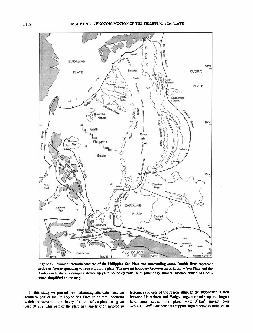
Eastern Indonesia includes the junction between three major plates (Figure 1). Relative to Eurasia, treated as a single plate, the Australian Plate is moving NNE at about 75 mm/yr [DeMets et al., 1990], and the Philippine Sea Plate moves WNW at about 100 mm/yr [Send et al., 1993]. The margins of Eurasia in SE Asia must be considered as involving numerous small plates and plate boundaries that have shifted and evolved on timescales of a few million years. In the Philippines, active island arcs are separated from the Eurasian continent by small basins floored by oceanic crust. The Philippine arcs end in the south in the
Molucca Sea collision complex (Figure 2) where the Halmahera and Sangibe Arcs are actively converging. The Molucca Sea Plate has an inverted U-shaped configuration [Hatherton and Dickinson, 1969; Katili, 1975; Hamilton, 1979; Cardwell et al.,
1980; McCafire.v, 1982] and dips east under Halmahera and west under the Sangibe Arc. Regional seismicity [McCafire.v, 1982] suggests that the east dipping slab extends 200-300 km beneath Halmahera. The west dipping slab can be identified to 600 km beneath the Celebes Sea [Cardwell et al., 1980].
The Philippine Sea Plate is currently rotating clockwise with respect to Eurasia about an Euler pole close to its northern edge, based on geological, geophysical, and seismological observations along the plate margins [Ranken et al., 1984; Huchon, 1986; Send et al., 1987; Send et al., 1993]. The rate of convergence increases southward, resulting in westward subduction at the Philippine Trench, which terminates just north of Halmahera at 2ø50'N. The Philippine Trench formed later than 5 Ma and is associated with less than 150 km of subducted lithosphere [Cardwell et al., 1980; Karig, 1975] implying that before the Pliocene, parts of the east Philippines formed part of the Philippine Sea Plate. Hamilton [1979] joined the Philippine Trench to the New Guinea Trench with a strike-slip fault east of Halmahera and placed Halmahera on a microplate separate from the Philippine Sea Plate. However, recent studies of seismicity and marine geology [Cardwell et al., 1980; McCaffre.v, 1982; Moore and Silver, 1983; Nichols et al., 1990] indicate that the Halmahera-Waigeo islands form part of the Philippine Sea Plate [Hall and Nichols, 1990]. The southern boundary of both the Molucca Sea and the Philippine Sea Plate is the Sorong Fault system (Figure 2), which is the western end of a zone of left- lateral strike-slip faults extending from northern New Guinea [Carey, 1958], resulting from the oblique convergence of
....... 124'E/ Celebes
Sea: /////////
SULAWESI
Molucca Sea
Collision Complex
BANGGAI :
' ' ,'ISLANDS ,• x x x x x x x x x x x x
• ........................... 132'E
• • ===================================== e ................. ß ........ i=,hilippin .......
Sea F'la ....... Lili .......................................
:Wayatoll ..........................................
•owonli .......................................
i i!iiiiii!i WAIGEO
a^• :•iii ' ' ' •"•"• ..... ::: ...... I•A'rANTA ...........
.... • ,,,a,,.•,•-.• •
.' •..'...•.OLUC. CA •01•N• F^ULT' ' ........... . • • • • • •
': ::::::::::::::::::::::::::::::::::::::: x ,• x ,• x x x x x x x x x x x x x x x x x x x x x x x x x x x ,• x x x
Figure 2. Principal tectonic features of the Sorong Fault Zone. Australian continental crust (indicated by crosses) is found only south of the Sorong Fault strand passing through Bacan. North of this fault is crust of arc or ophiolitic origin which is part of the Philippine Sea Plate. Solid triangles indicate active volcanoes. Solid circles show the location of sites from which palaeomagnetic samples discussed in this study were collected.
1120 HALL ET AL.: CENOZOIC MOTION OF THE PHILIPPINE SEA PLATE
Australia and the Pacific. The Sorong Fault has its type locality in the northern Bird's Head region of New Guinea [Visser and Hermes, 1962; Dow and Sukamto, 1984]. We use the term Sorong Fault Zone for an area including the region from the Bird's Head to east Sulawesi.
Geology of the Sorong Fault Zone
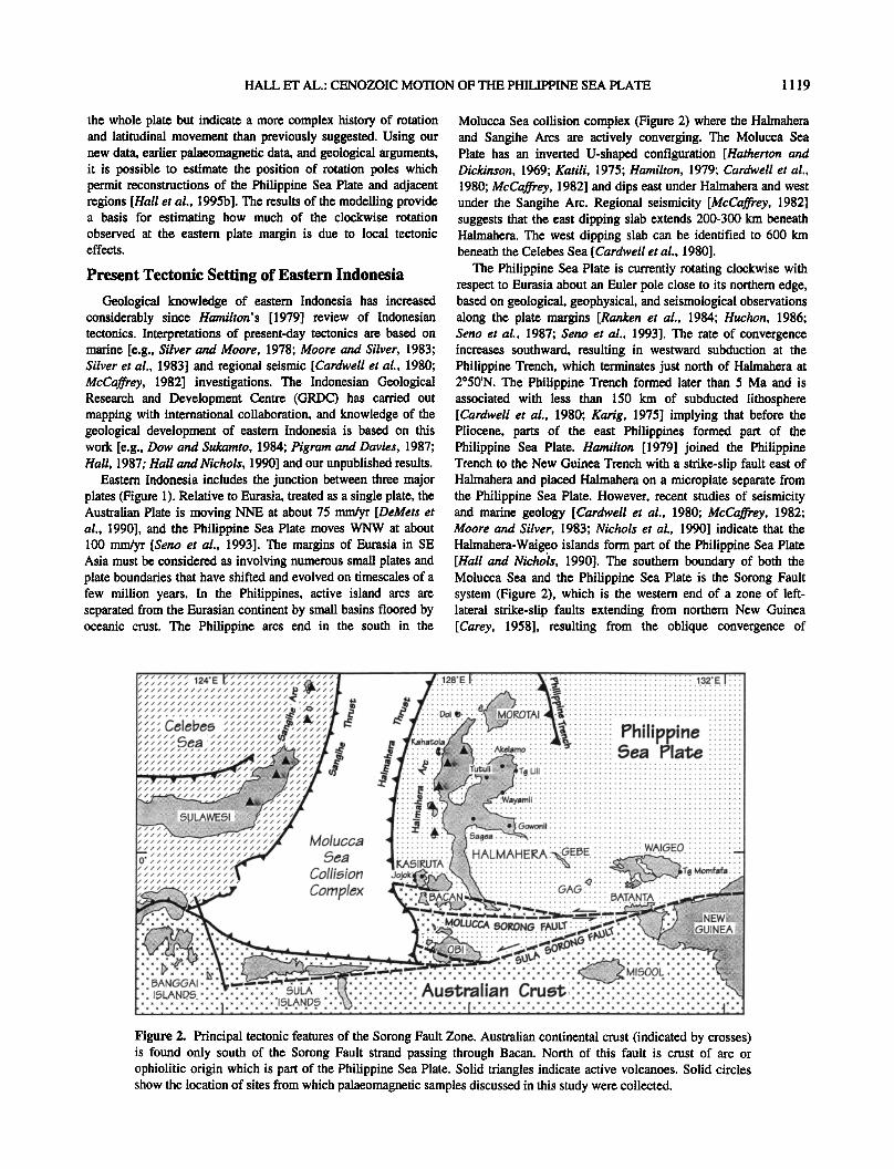
This geological summary is based on fieldwork carried out by London University and GRDC geologists [Hall et al., 1988a, b; Nichols and Hall, 1991; Charlton et al., 1991; Hall et al., 1991; Hall et al., 1995a, R. Hall et al., unpublished results, 1995]. The Sorong Fault system juxtaposes continental, arc, and ophiolitic rocks (Figures 2 and 3). Australian continental crust is present on the islands of Obi and Bacan within the Sorong Fault system [Hamilton, 1979; Ali and Hall, 1995]. High-grade metamorphic rocks of probable Palaeozoic or greater age are exposed on Bacan and Obi, and lower and middle Jurassic sedimentary rocks, forming the cover to the metamorphic basement, are present in southern Obi.
The region north of, and much of the area between the strands of, the Sorong Fault have a basement of ophiolitic and arc rocks
[Hall et al., 1991]. The ophiolites are remnants of an early Mesozoic intraoceanic arc [Hall et al., 1988a, Ballantyne, 1991a, b] and are overlain by, and imbricated with, upper Cretaceous- Eocene arc volcanic and sedimentary rocks; arc plutonic rocks intrude the ophiolites. These are interpreted as equivalents of Paleogene arc rocks of northern New Guinea [Dow and Sukamto, 1984; Pigram and Davies, 1987], the eastern Philippines [Rangin, 1991], and ridges of the north Philippine Sea [Tokuyama, 1985; Hall and Nichols, 1990]. A middle Eocene unconformity marks plate reorganisation, perhaps linked to change in Pacific Plate motion at -42 Ma [Clague and Jarrard, 1973]. Older rocks are overlain by shallow water upper Eocene limestones and Oligocene basaltic pillow lavas and volcaniclastic turbidites. The lavas and volcaniclastic rocks are arc-related
products which also have equivalents in New Guinea [Dow and Sukamto, 1984; Pigram and Davies, 1987] and the Philippines [Rangin, 1991 ]. Arc activity ceased by the early Miocene.
Fragments of continental, arc, and ophiolitic origin have a common history from the early Miocene, and there was no significant Neogene volcanic activity along the Sorong Fault. Collision between a Philippine Sea Plate bounding arc and the Australian continental margin occurred at -25 Ma and led to
Qua•rnary
u
Pliocene - L
_
u
Miocene M
L
U
Olioocene L
U
Eocene M
L
Paleocene
Cretaceous
Ju•ssic
Triassic
Palaeozoic
-1.6 Kayasa Formation
-5.2
-23.3
-35.4
-56.5
-65.0
(E Halmahem) 5aolat Formation (W Halmahem) We•la Group
Volcanic Member
(Waigeo) F, umai Formation (Halmahem) Tawall Formation
Jojok Member
Sagea Formation Wayamli Formation
(NE Halmahera) Gau Lst Formation (fie Halmahem) Gowonli Formation
Age Ma
v v v v v v v,.l•:l:;:l •
v v v v v v v v v
?HILIF?INE PLATE
ORIGIN
Present Halmahe• Arc Volcanism
MOVEMENT ON SORONG FAULT STRANDS
Neogene Halmahe• Arc Volcanism
MOLUCCA SEA SUBDUCTION BEGINS
SORONG FAULT INITIATED
AUSTRALIA-PHILIPPINE SEA PLATE ARC COLLISION
Philippine Sea Plate Arc Volcanism
PACIFIC PLATE REORGANISATION
Arc Volcanism
Arc Volcanism
Arc Volcanism
Sup•-subduction Zone Igneous Activity
v:v'v'v'v'v'v:v:4
v :v.m v: 4 v.v.v.v.v.v.v.v•
.V .V .V•
iil111 L!m•?•,ng? ii1 I II I I I • I • • •
I I I I I I I I I
: !•lack 5halee -- -- Micac•ou• 5•t• --
F, ock• • •
AU,STL!AN ORI,IN
Figure 3. Simprifled stratigraphy of Philippine Sea Plate rocks north of the Sorong Fault and within fault strands and Australian-origin rocks now within the fault system. The ages of principal events in the geological history of the region are based on the timescale of Harland et al. [ 1990].

HALL ET AL.: CENOZOIC MOTION OF THE PHILIPPINE SEA PLATE 1 121
Table la. Ages and Locations of Neogene Sites
Kahatola, NW Halmahera Tanjung Lili, NE Halmahera Kahatola, NW Halmahera
Stratigraphic Unit Age
Kayasa Formation Pliocene Saolat Formation Mio-Pliocene
Weda Group Upper Miocene
Ma Dating Method Latitude, Longitude
2.2 _.+ 0.7 K-At 1 ø42.49'N, 127ø31.25'E 5 _+ 1 Forams 1ø15.55'N, 128ø43.62'E 7 + 2 K-At 1ø41.08'N, 127ø31.90'E
creation of the left-lateral Sorong Fault Zone [Ali and Hall, 1995]. Northward movement of Australia during the Neogene occurred without subduction, and the southern plate boundary has been a strike-slip plate boundary zone. Neogene convergence between Eurasia and the Philippine Sea Plate resulted in subduction of the Molucca Sea producing the Halmahera Arc. Volcanic activity continues at present in the northern part of the Halmahera Arc.
The Halmahera-Waigeo islands today form part of the Philippine Sea Plate. They, together with most of the islands within the fault system, include Tertiary rocks which have a long volcanic arc history, and the oldest rocks known are ophiolites which also formed in an arc-related setting. The significant similarities to Tertiary rocks elsewhere on the Philippine Sea Plate [Hall and Nichols, 1990], and to areas such as the east Philippines, support the suggestion that all these areas formed part of the Philippine Sea Plate throughout most of the Cenozoic. We here test this hypothesis, which is based on interpretation of present-day tectonics and geological evidence, using palaeomagnetic methods.
Palaeomagnetic Methods
Palaeomagnetic results should provide a key test of tectonic models for the region. With our new stratigraphic base we have been able to systematically sample rocks of virtually all ages between Jurassic and Neogene. Palaeomagnetic investigations were supported by a dating programme, and the ages of the formations reported here, with one exception, were determined during this study using K-Ar isotopic, nannoplankton, and foraminiferal studies. Biostratigraphic determinations, which in many cases allow resolution to a single fossil zone, have been
converted to numerical ages using the scheme of HaHand et al. [ 1990]. At each site, 25-mm cores were obtained using a gasoline powered rock drill and oriented to _+ 2 ø using a magnetic compass inclinometer. The magnetic stability of each specimen was assessed using either stepwise alternating field (AF) demagneti- sation or continuous thermal demagnetisation [Dunn and Fuller, 1984]. Demagnetisation data were analysed using equal area and orthogonal [Zijderveld, 1967] plots from which characteristic components of remanence for each specimen were determined. Site mean directions were computed using the statistics of Fisher [1953]. Site data are presented in Tables 1 to 3.
Palaeomagnetic Results
The magnetisations of the 254 sites sampled during this study fall into four groups:
1. The first is Mesozoic and Tertiary rocks of Australian origin. These rocks are typically weakly magnetised. Only a few sites yielded directional information and results are discussed elsewhere [Ali and Hall, 1995].
2. The second group is Neogene limestones. Despite attempts at measurement of remanence using 2G cryogenic magnetometers at Southampton and University of California, Santa Barbara (UCSB) and a Cryogenic Consultants Limited magnetometer at Southampton, the rocks were too weakly magnetic to obtain reliable data.
3. The third group is Neogene volcanogenic sedimentary rocks. These rocks are strongly magnetic and formed over 25% of the samples collected. However, they carry a large viscous remanence. After initial failure to obtain reliable data from these
rocks in the laboratory at Southampton, we attempted to measure specimens from all of these sites in the shielded laboratory at
Table lb. Palaeomagnetic Results from Neogene Sites
In Situ
Site Rock Type N A/T Inc Dec tz9s
HC6 andesite 7 6,1 42.7 191.5 1.9 HC7 andesite 6 4,2 42.9 175.6 7.4
HC22 calcisiltite 5 5,0 -4.2 5.5 4.2 HC24 calcisiltite 9 0,9 -10.2 9.1 7.3
HC 1 andesite 8
HC2 andesite 9 6,2 54.1 195.7 9.0 7,2 51.4 195.3 3.2
Corrected Correct•½l K Bedding Inc Dec Regional Tilt Inc Dec Polarity
Kayasa Formation
1063.8 088/36 S 7.2 187.9 090/16 S 26.9 189.8 R
83.6 322/25 NE 51.7 149.5 090/16 S 27.0 176.7 R
Sa01at Formation
332.6 180/22 W -2.5 7.1 N
51.2 146/16 SW 0.5 10.1 N
Weda Group
238.7 330/05 NE 52.4 191.5 090/16 S 38.4 192.2 R
256.2 330/05 NE 55.1 192.0 090/16 S 35.7 192.2 R
Abbreviations are N, number of samples at site; Inc, inclination in degrees; Dec, declination in degrees; %5, circle of 95 % confidence about the site mean; In Situ, site mean direction before application of tectonic correction; Corrected, site mean direction after tectonic correction; A/T, demagnetisation method: A, alternating field; T, thermal; K, precision parameter; Polarity: N, normal, R, reversed.
1 122 HALL ET AL.: CENOZOIC MOTION OF THE PHILIPPINE SEA PLATE
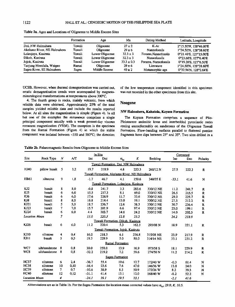
Table 2a. Ages and Locations of Oligocene to Middle Eocene Sites
Formation Age Ma Dating Method
Doi, NW Halmahera Tawali Oligocene 27 _.+ 2 K-Ar Akelamo River, NE Halmahera Tawali Oligocene 29 _+ 6 Nannofossils Loleojaya, Kasiruta Tawali Lower Oligocene 32.3 _.+ 3 Forams,Nannofossils Dikoh, Kasiruta Tawali Lower Oligocene 32.3 _.+ 3 Nannofossils Jojok, Kasiruta Tawali Lower Oligocene 33.3 _.+ 0.3 Forams, Nannofossils Tanjung Momfafa, Waigeo Rumai Oligocene 29 _+ 6 Literature Sagea River, SE Halmahera Sagea Middle Eocene 40 _.+ 2 Metamorphic age
Latitude, Longitude
2ø15.50'N, 128ø46.00'E 1 ø24.50'N, 128ø38.60'E 0ø21.40'S, 127ø15.00'E 0ø23.60'S, 127ø6.40'E 0 ø 19.20'S, 127ø6.50'E
1 ø24.50'N, 128ø38.60'E 0ø32.94'N, 128ø2.64'E
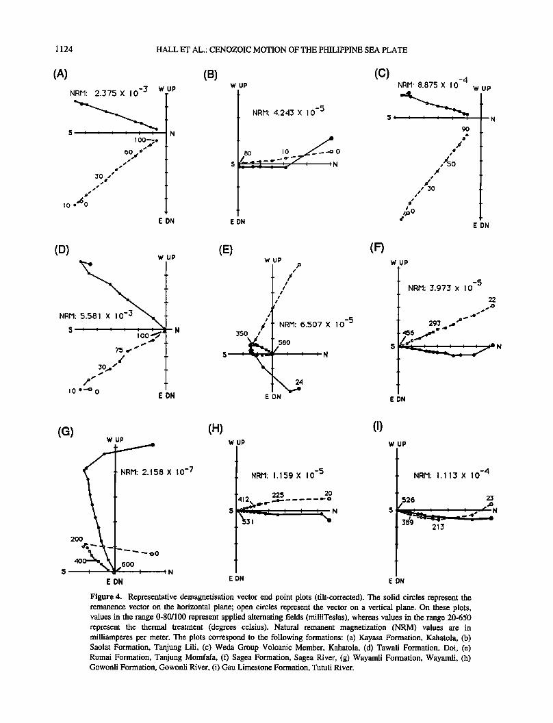
UCSB. However, when thermal demagnetisation was carried out, erratic demagnetisation trends were accompanied by magneto- mineralogical transformations at temperatures above 300øC.
4. The fourth group is rocks, mainly volcanic, from which reliable data were obtained. Approximately 25% of the total samples yielded reliable data and include the results reported below. At all sites the magnetisation is simple (Figure 4). In all but one of the examples the remanence comprises a single principal component usually with a weak present-day viscous remanent magnetization (VRM). The exception is the specimen from the Rumai Formation (Figure 4) in which the stable component was isolated between-350 and 580øC; the direction
of the low temperature component identified in this specimen was not recorded in the other specimens from this site.
Neogene
NW Halmahera, Kahatola, Kayasa Formation
The Kayasa Formation comprises a sequence of Plio- Pleistocene andesitic lavas and interbedded pyroclastic rocks resting unconformably on sandstones of the Oligocene Tawali Formation. Flow-banding surfaces' parallel to flattened pumice fragments have dips between 25 ø and 35 ø. Two sites drilled in a
Table 2b. Palaeomagnetic Results from Oligocene to Middle Eocene Sites
Site Rock Type N A/T
HJ40 pillow basalt 5 3,2
HB61 siltstone 9 1,8
KJ2 basalt 8 8,0 KJ5 basalt 6 6,0 KJ6 basalt 6 6,0 KJ8 basalt 8 8,0 KJ21 basalt 5 5,0 KJ23 basalt 7 7,0 KJ24 basalt 6 6,0 Location Mean 7
KJ26 basalt 6 6,0
KJ 10 siltstone 4 0,4 KJ 11 basalt 5 0,5
WC7 silt/sandstone 8 0,8 WC8 silt/sandstone 8 0,8
HC37 siltstone 6 2,4 HC38 siltstone 10 0,10 HC39 siltstone 7 0,7 HC40 siltstone 12 0,12 Location Mean 4
In $itu
Inc Dec 595 K Bedding Tawali Formation, Doi, NW Halmahera
19.7 218.9 4.8 253.3 260/12 N
Tawali Formation, Akelamo River, NE Halmahera
-1.7 46.7 4.1 159.6 340/35 E
Tawali Formation. Loleojaya. Kasiruta -0.8 241.7 3.3 283.6 330/12 NE
15.5 217.3 8.1 69.0 330/12 NE 17.6 226.9 11.7 33.6 330/12 NE 16.8 214.4 13.0 19.1 330/12 NE 18.7 236.7 12.6 38.3 330/12 NE
15.7 201.9 6.6 97.4 330/12 NE
4.4 203.7 14.0 24.2 330/12 NE
13.0 220.3 12.8 23.2
Tawali Formation, Dikoh, Kasiruta 11.2 220.4 5.3 162.3 295/08 N
Tawali Formation. Jojok. Kasiruta
Corrected
Inc Dec Polarity
27.5 222.3 R
-33.1 41.6
11.2
26.5
29.3
27.5
30.7
25.0
14.0
24.2
241.7
215.5
225.7
212.2
236.4
199.1
202.5
218.9
18.9 221.1
16.0 218.3 6.1 236.8 315/08 NE 23.9 19.3 229.9 5.0 88.0 314/14 NE 33.1
Rumai Formation
30.0 258.0 13.9 16.9 073/58 S 18.1 -32.2 219.2 7.2 59.6 274/50 N 11.2
Saeea Formation
-36.7 55.4 19.6 12.7 172/40 W -0.3 - 16.4 23.6 7.6 47.0 146/36 W 13.8 - 10.6 38.9 8.5 50.9 172/26 W 8.2 -31.1 41.4 13.1 12.0 168/40 W -8.2
-24.1 39.1 19.5 23.1 -2.1
Abbreviations are as in Table lb. For the Sagea Formation the location mean corrected values have %5, 29.8; K, 10.5.
217.9
231.2
229.9
214.2
61.4
24.0
39.3
52.2
41.6
R
R
R
R
N
N
N
N
HALL ET AL.: CENOZOIC MOTION OF THE PHILIPPINE SEA PLATE 1 123
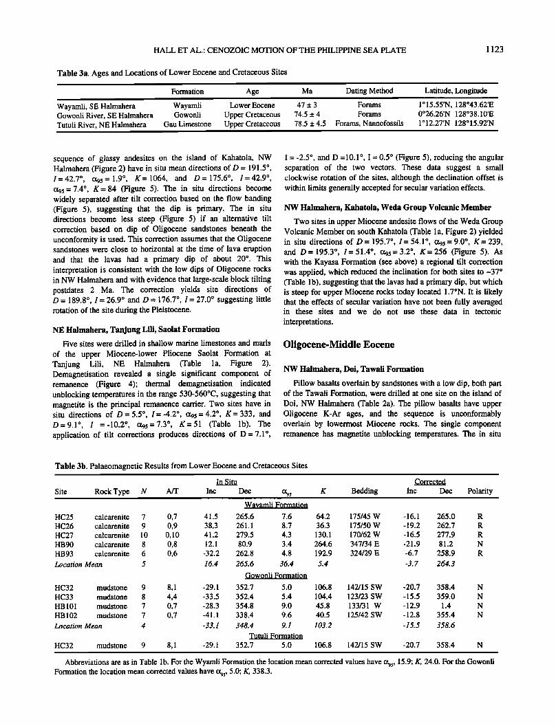
Table 3a. Ages and Locations of Lower Eocene and Cretaceous Sites
Wayamli, SE Halmahera Gowonli River, SE Halmahera Tutuli River, NE Halmahera
Formation Age Ma Dating Method
Wayamli Lower Eocene 47 +_ 3 Forams Gowonli Upper Cretaceous 74.5 +_ 4 Forams
Gau Limestone Upper Cretaceous 78.5 _+ 4.5 Forams, Nannofossils
Latitude, Longitude
1ø15.55'N, 128ø43.62'E 0ø26.26'N 128ø38.10'E
1 o 12.27'N 128 ø 15.92'N
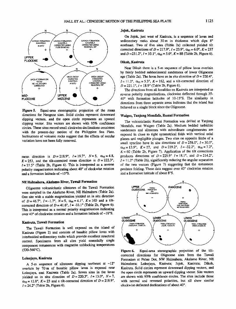
sequence of glassy andesites on the island of Kahatola, NW Halmahera (Figure 2) have in situ mean directions of D = 191.5 ø, I=42.7 ø , {x95 =1.9 ø , K=1064, and D=175.6 ø , I=42.9 ø, {x95 = 7.4 ø, K= 84 (Figure 5). The in situ directions become widely separated after tilt correction based on the flow banding (Figure 5), suggesting that the dip is primary. The in situ directions become less steep (Figure 5) if an alternative tilt correction based on dip of Oligocene sandstones beneath the unconformity is used. This correction assumes that the Oligocene sandstones were close to horizontal at the time of lava eruption and that the lavas had a primary dip of about 20 ø . This interpretation is consistent with the low dips of Oligocene rocks in NW Halmahera and with evidence that large-scale block tilting postdates 2 Ma. The correction yields site directions of D = 189.8 ø, I = 26.9 ø and D = 176.7 ø, I = 27.0 ø suggesting little rotation of the site during the Pleistocene.
NE Halmahera, Tanjung Lili, Saolat Formation
Five sites were drilled in shallow marine limestones and marls
of the upper Miocene-lower Pliocene Saolat Formation at Tanjung Lili, NE Halmahera (Table la, Figure 2). Demagnetisation revealed a single significant component of remanence (Figure 4); thermal demagnetisation indicated unblocking temperatures in the range 530-560øC, suggesting that magnetite is the principal remanence carrier. Two sites have in situ directions of D= 5.5 ø, I=-4.2 ø, o•95 =4.2 ø, K= 333, and D=9.1ø, I =-10.2 ø , o•0•=7.3 ø , K=51 (Table lb). The application of tilt corrections produces directions of D = 7.1 ø,
I =-2.5 ø, and D =10.1 ø, I = 0.5 ø (Figure 5), reducing the angular separation of the two vectors. These data suggest a small clockwise rotation of the sites, although the declination offset is within limits generally accepted for secular variation effects.
NW Halmahera, Kahatola, Weda Group Volcanic Member
Two sites in upper Miocene andesite flows of the Weda Group Volcanic Member on south Kahatola (Table 1 a, Figure 2) yielded in situ directions of D = 195.7 ø, I = 54.1 o, o•95 = 9.0 ø, K = 239, and D= 195.3 ø, I= 51.4 ø, o•95 = 3.2 ø, K= 256 (Figure 5). As with the Kayasa Formation (see above) a regional tilt correction was applied, which reduced the inclination for both sites to -37 ø (Table 1 b), suggesting that the lavas had a primary dip, but which is steep for upper Miocene rocks today located 1.7øN. It is likely that the effects of secular variation have not been fully averaged in these sites and we do not use these data in tectonic
interpretations.
Oligocene-Middle Eocene
NW Halmahera, Doi, Tawali Formation
Pillow basalts overlain by sandstones with a low dip, both part of the Tawali Formation, were drilled at one site on the island of
Doi, NW Halmahera (Table 2a). The pillow basalts have upper Oligocene K-Ar ages, and the sequence is unconformably overlain by lowermost Miocene rocks. The single component remanence has magnetite unblocking temperatures. The in situ
Table 3b. Palaeomagnetic Results from Lower Eocene and Cretaceous Sites
In Situ Corrected
Site Rock Type N AFF Inc Dec c•95 K Bedding Inc Dec Polarity
Wayamli Formation
HC25 calcarenite 7 0,7 41.5 265.6 7.6 64.2 175/45 W -16.1 265.0 R HC26 calcarenite 9 0,9 38.3 261.1 8.7 36.3 175/50 W -19.2 262.7 R HC27 calcarenite 10 0,10 41.2 279.5 4.3 130.1 170/62 W - 16.5 277.9 R HB90 calcarenite 8 0,8 12.1 80.9 3.4 264.6 347/34 E -21.9 81.2 N HB93 calcarenite 6 0,6 -32.2 262.8 4.8 192.9 324/29 E -6.7 258.9 R Location Mean 5 16.4 265.6 36.4 5.4 -3.7 264.3
G0wonli Formation
HC32 mudstone 9 8,1 -29.1 352.7 5.0 106.8 142/15 SW -20.7 358.4 N HC33 mudstone 8 4,4 -33.5 352.4 5.4 104.4 123/23 SW -15.5 359.0 N HB 101 mudstone 7 0,7 -28.3 354.8 9.0 45.8 133/31 W -12.9 1.4 N HB102 mudstone 7 0,7 -41.1 338.4 9.6 40.5 125/42 SW -12.8 355.4 N Location Mean 4 -33.1 348.4 9.1 103.2 -15.5 358.6
Tutuli Formation HC32 mudstone 9 8,1 -29.1 352.7 5.0 106.8 142/15 SW -20.7 358.4 N
Abbreviations are as in Table lb. For the Wyamli Formation the location mean corrected values have c•05, 15.9; K, 24.0. For the Gowonli Formation the location mean corrected values have %•, 5.0; K, 338.3.
1124 HALL ET AL.: CENOZOIC MOTION OF THE PHILIPPINE SEA PLATE
(A) (B) (C) -3
NRM: 2.375 X I0
1 O0 •-•e
30•
10 .•0
W UP
E DN
w up
-5 NRM: 4.243 X I0
)N
-4 NRM: 8.875 X I0
90
ß 30
wup
E DN
(D)
NRM:
ß i oo.:-•.
WUP (E)
E DN E DN
wup
!
/ /
"t / NRM: 6.507 X 10 -5 350 /
0
(F) wup
-5 NRM: 3.973 x 10
,,• 293 .•
456 •a 'e e '"e ./•.•-• ..... S -- - ;•e N
E DN
(G) w up
(H) (I) W UP W UP
2OO
NRM: :2.158 X 10 -7
600
-5 NRM: !.159 X I0
225 20 412. e.,, ..,e_ ..... e-o
531
E DN E DN E DN
-4 NRM: 1.113 X 10
526 23
$ L/38'9• : : '"" -' N 213
Figure 4. Representative demagnetisation vector end point plots (tilt-corrected). The solid circles represent the remanence vector on the horizontal plane; open circles represent the vector on a vertical plane. On these plots, values in the range 0-80/100 represent applied alternating fields (milliTeslas), whereas values in the range 20-650 represent the thermal treatment (degrees celsius). Natural remanent magnetization (NRM) values are in milliamperes per meter. The plots correspond to the following formations: (a) Kayasa Formation, Kahatola, (b) Saolat Formation, Tanjung Lili, (c) Weda Group Volcanic Member, Kahatola, (d) Tawall Formation, Doi, (e) Rumai Formation, Tanjung Momfafa, (f) Sagea Formation, Sagea River, (g) Wayamli Formation, Wayamli, (h) Gowonli Formation, Gowonli River, (i) Gau Limestone Formation, Tutuli River.
HALL ET AL.: CENOZOIC MOTION OF THE PHILIPPINE SEA PLATE 1125
N N N
u?
PLIOCENE '•• N N N
u
P LIO CE N..•,.••// MIOCEN E• Figure 5. Equal-area stereographic projection of the mean directions for Neogene sites. Solid circles represent downward dipping vectors, and the open circle represents an upward dipping vector. Site vectors are shown with 95% confidence circles. These sites record small clockwise declinations consistent
with the present-day motion of the Philippine Sea Plate. Inclinations of volcanic rocks suggest that the effects of secular variation have not been fully removed.
mean direction is D=218.9 ø, I=19.7 ø , N=5, (x95=4.8, K= 253, and the tilt-corrected mean direction is D= 222.3 ø, I = 27.5 ø (Table 2b, Figure 6). This is interpreted as a reverse polarity magnetisation indicating about 40 ø of clockwise rotation and a formation latitude of ~ 15øS.
Jojok, Kasiruta
On Jojok, just west of Kasiruta, is a sequence of lavas and sedimentary rocks about 30m in thickness which dips 8 ø northeast. Two of five sites (Table 2a) collected yielded tilt corrected directions of D = 217.9 ø, I = 23.9 ø, (x9s = 6.0 ø, K = 237 and D =231.2 ø, I = 33.1ø, (•s = 5.0ø, K = 88 (Table 2b, Figure 6).
Dikoh, Kasiruta
Near Dikoh there is a 5-m sequence of pillow lavas overlain by thinly bedded subhorizontal sandstones of lower Oligocene age (Table 2a). The lavas have an in situ direction of D = 220.4 ø, I= 11.2 ø, c•95 = 5.3 ø, K= 162, and a tilt-corrected direction of D = 221. l o, I = 18.9 ø (Table 2b, Figure 6).
The directions from all localities on Kasiruta are interpreted as reverse polarity magnetisations, clockwise deflected through 35- 40 ø with formation latitudes of 10-15øS. The similarity in directions from three separate areas indicates that the island has behaved as a single block since the Oligocene.
Waigeo, Tanjung Momfafa, Rumai Formation
The volcaniclastic Rumai Formation was drilled at Tanjung Momfafa, east Waigeo (Table 2a). Medium bedded turbiditic sandstones and siltstones with subordinate conglomerates are exposed in close to tight symmetrical folds with vertical axial planes and negligible plunges. Two sites on opposite limbs of a small syncline have in situ directions of D = 258.0 ø, I = 30.0 ø, (z95 =13.9 ø , K=17, and D=219.2 ø , I=-32.2 ø , (•95 =7.2ø, K = 60 (Table 2b, Figure 7). Application of the tilt corrections produces directions of D = 229.9 ø I = 18.1 o, and D = 214.2 ø, i = 11.2 ø (Table 2b), significantly reducing the angular separation of the two vectors (Figure 7) suggesting that the remanence predates folding. These data suggest over 40 ø clockwise rotation and a formation latitude of about 8øS.
NE Halmahera, Akelamo River, Tawali Formation
Oligocene volcaniclastic siltstones of the Tawali Formation were sampled in the Akelamo River, NE Halmahera (Table 2a). One site with a stable magnetisation yielded an in situ direction of D = 46.7 ø, I = - 1.7 ø, N = 9, (x95 = 4.1 o, K = 160 and a tilt- corrected direction of D = 41.6 ø, I=-33.1 ø (Table 2b, Figure 6). This is interpreted as a normal polarity magnetisation indicating over 40 ø of clockwise rotation and a formation latitude of ~ 18øS.
Kasiruta, Tawali Formation
The Tawali Formation is well exposed on the island of Kasiruta (Figure 2) and consists of basaltic pillow lavas with interbedded sedimentary rocks which provide excellent structural control. Specimens from all sites yield essentially single component remanences with magnetite unblocking temperatures (530-560øC).
Loleojaya, Kasiruta
A 5-m sequence of siltstones dipping northeast at ~12 ø overlain by 70m of basaltic pillow lavas is exposed near Loleojaya, east Kasiruta (Table 2a). Seven sites in the lavas yielded an in situ direction of D= 220.3 ø, I= 13.0 ø, N= 7, (x95 = 12.8 ø, K = 23 and a tilt-corrected direction of D = 218.9 ø, I = 24.2 ø (Table 2b, Figure 6).
N N
UP'FEE r,,,///••• OLIG
OLIGOCENE FOF..MATION • / .. DOI
TAWALl / \ . FOF, M^TION •. ^KELAMO I•IVEI•
N E HAL• N N N
OLI•OCENE • OLI•OCENE
Figure6. Equal-area stereographic projection of the tilt- corrected directions for Oligocene sites from the Tawall Formation at Pulau Doi, NW Halmahera; Akelamo River, NE Halmahera; Loleojaya, Kasiruta; Jojok, Kasiruta; Dikoh, Kasiruta. Solid circles represent downward dipping vectors, and the open circle represents an upward dipping vector. Site vectors are shown with 95% confidence circles. The sites include those
with normal and reversed polarities, but all show similar clockwise deflected declinations of about 40 ø .

1126 HALL ET AL.: CENOZOIC MOTION OF THE PHILIPPINE SEA PLATE
SE Halmahera, Sagea River, Sagea Formation
Middle Eocene volcaniclastic rocks of the Sagea Formation were drilled in the Sagea River, SE Halmahera (Table 2a). The rocks have a weak cleavage and were metamorphosed to subgreenschist facies (T < 400øC) in the middle Eocene. Four sites yielded an in situ component, defined between 100øC and 450-500øC, with a direction of D= 39.1 ø, I= -24.1 ø, (x95 = 19.5 ø, K= 23 (Table 2b, Figure 7). Application of individual site tilt corrections increases the dispersion of the sites (D= 41.6 ø, I = -2.10, (x95 = 29.8 ø, K = 11) suggesting that the magnetisation postdates tilting. The formation is unconformably overlain by Miocene limestones with no appreciable dip suggesting no regional tilt correction is required. The in situ direction is clearly not a recent low-temperature component. We interpret it as a
N N
LOWER
'•, NE H^LIVI^HEIKA '•, N•_AL._M^HE_IKA
N N
middle Eocene normal polarity magnetisation associated with metamorphism indicating-40 ø of clockwise rotation and a formation latitude of about 13øS.
N N
OLin/OC F,.U
W^I•EO / ,.•W•E,.•.O ,., \
U??
CRETACEOUS -I- j \ I GOWONLiFORMA•T•3N I GOWONLiF•ORMATiO N
•. ,SE H^LM^HEF.• •, ,SE_H__ALM_AHEF.•-- -
N N
UFF CIRE
'• NE "ALMAHERA '• CORRECTED /
.•,;;•,:.•... Figure 8. Equal-area stereographic projection of the site mean
+ -
5AGEA FOF, M^TION 5AGEA FOF, M^TION •, 5E HALMAHEF-,A / 5E HALMAHEF-,A /
Figure 7. Equal-area stereographic projections of the site mean directions (before and after tilt correction) for the Oligocene Rumai Formation, Waigeo, and the middle Eocene Sagea Formation, SE Halmahera. Solid circles represent downward dipping vectors, and open circles represent upward dipping vectors. Site vectors are shown with 95% confidence circles. All
these sites record similar declinations to those of the Tawali
Formation despite being distributed throughout a large area, indicating a consistent post-Oligocene rotation for the entire region.
directions (before and after tilt correction) for the lower Eocene Wayamli Formation, NE Halmahera, the Cretaceous Gowonli Formation, SE Halmahera, and Gau Limestone Formation, NE Halmahera. Solid circles represent downward dipping vectors, and open circles represent upward dipping vectors. The site vectors are shown with 95% confidence circles. For the Wayamli Formation, in situ and tilt-corrected directions for site HC90 have been inverted, and the declinations are interpreted to indicate -90 ø rotation since the early Eocene. Inclinations of Cretaceous rocks indicate subequatorial formation latitudes and suggest 180 ø rotation since the late Cretaceous.
Lower Eocene
The lower-middle Eocene Wayamli Formation consists of redeposited slope limestones and interbedded red and green carbonate mudstones. At Wayamli the sequence dips at 30-60 ø to both east and west. The strike of the beds remains constant over a

HALL ET AL.: CENOZOIC MOTION OF THE PHILIPPINE SEA PLATE 1127
distance of a few kilometres indicating folds with negligible plunge although fold axes are not exposed. Folding is probably of middle Eocene age. Five sites (Table 3a) have an in situ mean direction of D = 265.6 ø, I = 16.4 ø, et95 = 36.4 ø, K = 5 (Table 3b). In Figure 8 the in situ and tilt-corrected direction for site HC90 is inverted. After tilt correction, D = 264.3 ø, I =-3.7 ø, et95 = 15.9 ø, K = 24. The locality includes both normal and reversed polarity sites, which are excellent evidence to suggest that the magnetisation is primary. The tilt-corrected data pass both the McElhinny [1964] and the McFadden [1990] tests at the 95% confidence level indicating a prefolding magnetisation. We interpret this to indicate -85 ø of clockwise rotation with a formation latitude of-2øN.
Cretaceous
SE Halmahera, Gowonli River, Gowonli Formation
Limestones and interbedded volcaniclastic mudstones of the
Senonian Gowonli Formation were drilled in the Gowonli River, SE Halmahera (Table 3a). The sequence typically dips to the SW at about 15-30 ø although locally it is deformed by mesoscopic open folds. Folding is middle Eocene in age. Four sites yielded an in situ direction of D= 348.4 ø, 1 = -33.1 ø, et95 = 9.1 ø, K= 103 (Table 3b, Figure 8). Application of site tilt corrections produces a mean direction of D= 358.6 ø, I=-15.5 ø, et9s =-5.0 ø, K= 338 (Figure 8). This suggests that the remanence predates the middle Eocene folding. This direction can be interpreted either as a normal polarity remanence indicating negligible net rotation and a formation latitude of-8øS or as a reverse polarity remanence acquired at -8øN with 180 ø net rotation.
NE Halmahera, Tutuli River, Gau Limestone Formation
The upper Cretaceous Gau Limestone Formation was sampled in the Tutuli River, NE Halmahera (Table 3a) where there is a continuous 60-m sequence of thinly bedded limestones and volcanogenic turbidires dipping NW at 50-70 ø. Deformation occurred during the middle Eocene. One site has an in situ direction of D= 9.3 ø, I= 23.9 ø, •z9s = 7.7 ø, K = 63 (Table 3b, Figure 8 with a tilt-corrected direction of D= 1.4 ø, I=-4.0 ø. Demagnetisation isolated a single component (Figure 4) with unblocking temperatures of 550-580øC, suggesting that magnetite is the remanence carder in these rocks. Assuming a primary remanence, the direction indicates either a normal polarity with negligible rotation or a reverse polarity with -180 ø rotation. The site must have been close to the equator at formation.
Declination and Inclination Record
In the Sorong Fault Zone, palaeomagnetic data collected during this project from rocks underlain by crust of arc or ophiolitic origin (Figure 2) define two principal areas (Figure 9) with different tectonic histories: (1) the area north of the Sorong Fault and (2) the area within strands of the Sorong Fault.
Rotation North of the Sorong Fault
In the area north of the Sorong Fault we interpret declination shifts to indicate long-term, but discontinuous, clockwise rotation (Figure 10).
Neogene. The sites in upper Neogene volcanic and sedimentary rocks record small clockwise declination deflections consistent with those expected from angular velocities and rotation poles calculated for the present-day motion of the
Dr. Glina•on Change an& Apparent Northward Lat;iOudinal •hifO
15• Oli•ocene- Middle Eocene
filEUTA
I 124'E •
Figure 9. Summary of palaeomagnetic data obtained from the Sorong Fault Zone. The observed declination deflection (with confidence limit) in degrees for each locality is shown by the orientation of the solid arc segments. The apparent latitude change in degrees calculated from the inclination is indicated by the number on each arc segment.

1128 HALL ET AL.: CENOZOIC MOTION OF THE PHILIPPINE SEA PLATE
40
30
20
ß ß More than 3 sites in locality mean
ß ß 3 or fewer sites in locality mean
::3 10
I , , T 10 115
-10 lavae 'r
-2O --• -0- -30
I I
20 25 35 45 50 55 60 65 70 75
1
80 85 90
/•e Ma
lOO
8o
60
._o 40
.• 20
• o 5 10
-20
-40
-60
-80
15 20 25 30 35 40 45 50 55 60
Ma
ß [] Nort, h of
,5orong Fault, Zone
ß o Wit, hint, he
5orong Fault, Zone
Figure 10. Palaeolatitude and declination versus age for sites north of, and within, the Sorong Fault Zone.
Philippine Sea Plate [Ranken et al., 1984; Huchon, 1986; Seno et al., 1987; Seno et al., 1993]. Because the rocks are all <7 Ma, only the oldest volcanic rock sites show clear differences from the present field direction. However, their inclination values suggest that the effects of secular variation have not been fully removed. Despite drilling more than 50 sites in lower and middle Miocene rocks, we have obtained no interpretable results. Shallow marine lower-middle Miocene limestones were very weakly magnetic or showed unstable magnetic behaviour. Volcaniclastic rocks of this age carried a massive viscous remanence, and although some samples yielded reliable data, site statistics were inadequate; however, in most cases individual samples indicated clockwise declination shifts.
O!igocene.middle Eocene. Rocks of ages between -25 Ma and -40 Ma and with primary remanences show clockwise declination deflections of-40 ø. They comprise a variety of lithologies including basaltic and andesitic lavas, volcanogenic sediments, and impure limestones sampled over a very large area. The Tawali Formation includes sites with normal and reversed
polarities but with the same clockwise deflected declinations (Figure 6). Results from sites at one locality (Rumai Formation, Waigeo) pass a fold test. The 10 Tawali Formation sites on Kasiruta, from three localities spread over an area of-200 km 2, indicate that post-Oligocene faulting has not significantly affected the declination deflections. The Sagea Formation, with a remanence reset during middle Eocene metamorphism, shows 40 ø clockwise rotation. All these results are interpreted to
indicate that (1) the region has behaved as a single rigid block since -40 Ma, (2) no significant rotation took place between -25 and -40 Ma, (3) approximately 40 ø of clockwise rotation occurred after -25 Ma, and (4) this rotation occurred at an approximately constant rate.
Lower Eocene. The five sites drilled in steeply dipping lower Eocene limestones of the Wayamli Formation result have particular significance. The locality includes sites with normal and reverse polarities, and the results pass a fold test. We assume rigid block behaviour since the beginning of the Eocene. The declinations of-90 ø are therefore interpreted to indicate -90 ø total rotation with -45 ø of clockwise rotation between -50 and
-40 Ma.
Cretaceous. Primary magnetisations were obtained from two upper Cretaceous formations. These show northward declinations and low inclinations (indicating subequatorial tbrmation latitudes). We tentatively interpret these results to indicate rotations between the late Cretaceous and the early Eocene of -90 ø but do not include them in our tectonic modelling.
Rotations Within the Sorong Fault Zone
The island of Obi, situated within the Sorong Fault Zone, includes Australian continental rocks together with arc and ophiolitic rocks. The arc and ophiolitic rocks and their sedimentary cover record latitudinal shifts similar to rocks of comparable age and character north of the Sorong Fault Zone
HALL ET AL.: CENOZOIC MOTION OF THE PHILIPPINE SEA PLATE 1129
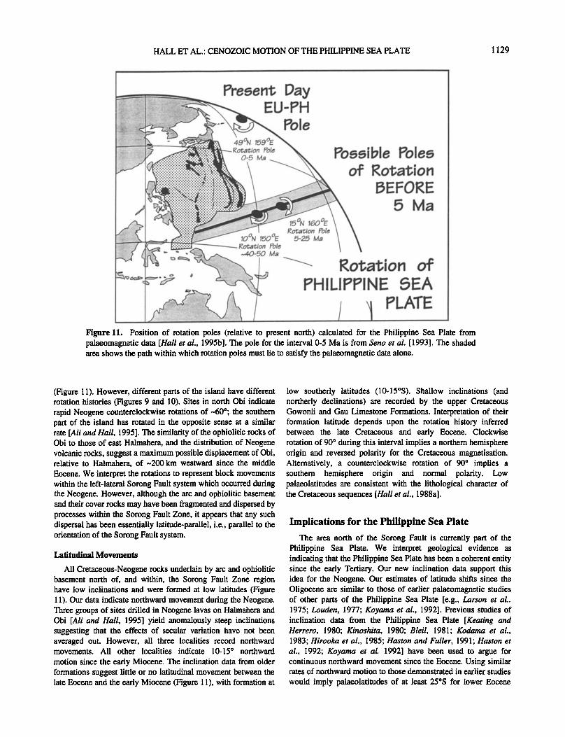
..'. .•:.: Rotation Pole .............. .,.... Poeelble Polee , oOo-o-,• •.. ß ====================== ::,•::. 6)-5
:::::::::::::::::::::::: :::.•:.. ß
' k Rotation of .............. PHILIPPINE ,SEA
/ PLATE Figure 11. Position of rotation poles (relative to present north) calculated for the Philippine Sea Plate from palaeomagnetic data [Hall et al., 1995b]. The pole for the interval 0-5 Ma is from Seno et al. [1993]. The shaded area shows the path within which rotation poles must lie to satisfy the palaeomagnetic data alone.
(Figure 11). However, different parts of the island have different rotation histories (Figures 9 and 10). Sites in north Obi indicate rapid Neogene counterclockwise rotations of ~60ø; the southern part of the island has rotated in the opposite sense at a similar rate [Ali and Hall, 1995]. The similarity of the ophiolitic rocks of Obi to those of east Halmahera, and the distribution of Neogene volcanic rocks, suggest a maximum possible displacement of Obi, relative to Halmahera, of ~200 km westward since the middle
Eocene. We interpret the rotations to represent block movements within the left-lateral Sorong Fault system which occurred during the Neogene. However, although the arc and ophiolitic basement and their cover rocks may have been fragmented and dispersed by processes within the $orong Fault Zone, it appears that any such dispersal has been essentially latitude-parallel, i.e., parallel to the orientation of the $orong Fault system.
Latitudinal Movements
All Cretaceous-Neogene rocks underlain by arc and ophiolitic basement north of, and within, the Sorong Fault Zone region have low inclinations and were formed at low latitudes (Figure 11). Our data indicate northward movement during the Neogene. Three groups of sites drilled in Neogene lavas on Halmahera and Obi [Ali and Hall, 1995] yield anomalously steep inclinations suggesting that the effects of secular variation have not been averaged out. However, all three localities record northward movements. All other localities indicate 10-15 ø northward
motion since the early Miocene. The inclination data from older formations suggest little or no latitudinal movement between the late Eocene and the early Miocene (Figure 11), with formation at
low southerly latitudes (10-15øS). Shallow inclinations (and northerly declinations) are recorded by the upper Cretaceous Gowonli and Gau Limestone Formations. Interpretation of their formation latitude depends upon the rotation history inferred between the late Cretaceous and early Eocene. Clockwise rotation of 90 ø during this interval implies a northern hemisphere origin and reversed polarity for the Cretaceous magnetisation. Alternatively, a counterclockwise rotation of 90 ø implies a southern hemisphere origin and normal polarity. Low palaeolatitudes are consistent with the lithological character of the Cretaceous sequences [Hall et al., 1988a].
Implications for the Philippine Sea Plate
The area north of the Sorong Fault is currently part of the Philippine Sea Plate. We interpret geological evidence as indicating that the Philippine Sea Plate has been a coherent entity since the early Tertiary. Our new inclination data support this idea for the Neogene. Our estimates of latitude shifts since the Oligocene are similar to those of earlier palaeomagnetic studies of other parts of the Philippine Sea Plate [e.g., Larson et al.. 1975; Louden, 1977; Koyama et al., 1992]. Previous studies of inclination data from the Philippine Sea Plate [Keating and Herrero, 1980; Kinoshita, 19'80; Bleil, 1981; Kodama et al., 1983; Hirooka et al., 1985; Haston and Fuller, 1991; Haston et
al., 1992; Koyama et al. 1992] have been used to argue for continuous northward movement since the Eocene. Using similar rates of northward motion to those demonstrated in earlier studies
would imply palaeolatitudes of at least 25øS for lower Eocene

1130 HALL ET AL.: CENOZOIC MOTION OF THE PHILIPPINE SEA PLATE
_
50 Ma
lOON 150OE Rot, at, ion Pole
40-50 Ma
Figure 12. Reconstructions of the Philippine Sea Plate at 5, 25, and 50 Ma using the rotation poles calculated from the results of this study by Hall et al. [1995b]. The shaded area shows the approximate area of the plate inferred to have been subducted.
Sorong Fault Zone sites, whereas the Wayamli Formation records subequatorial formation latitudes. However, a critical point is that the simple history inferred from DSDP data lacks declination control and there is an equatorial ambiguity for pre-Miocene sites. Louden [ 1977] explicitly pointed this out, and although he inferred a northward shift of the plate with decreasing age, he recognised that each mean palaeolatitude could have originated on either side of the equator. A knowledge of the rotation history of the plate is therefore vital in order to correctly calculate and interpret palaeolatitudes.
Palaeomagnetic studies of the plate have indicated clockwise declination shifts [Larson et al., 1975; Koyama et al., 1992], but the amount of rotation which can be attributed to motion of the entire plate has remained controversial. Studies of marine magnetic anomaly skewness in the Philippine Sea Plate also suggest clockwise rotations. Louden [1976] and Shih [1980] reported pole positions which imply about 60 ø of clockwise rotation for the West Philippine Basin since -44 Ma. Bowin et al. [1978] reported a pole implying about 50 ø of counterclockwise rotation, but the anomalies analysed were poorly defined [Jarrard and Sasajima, 1980]. In contrast, anomaly skewness data from the Shikoku Basin [Chamot-Rooke et al., 1989] have been interpreted to indicate no significant rotation since ~20 Ma. An early study of seamount magnetisation in the Shikoku Basin [Vacquier and Uyeda, 1967] has also been used to argue that there has been no significant rotation of the Philippine Sea Plate since 17 Ma [e.g., Seno and Maruyama, 1984]. The ages of the seamounts are unknown, but two of the three seamounts studied
are now known to be situated on young seafloor close to the spreading axis [Chamot-Rooke et al., 1987] and so can only have recorded the history of the last 15 m.y. Given the likely errors and assumptions in these studies the Shikoku Basin results could permit up to 20 ø rotation since ~20 Ma [Hall et al., 1995b]. Koyama et al. [1992] concluded that there has been clockwise rotation during the Neogene, but there were insufficient data to separate the component due to rotation of the entire plate from that due to local tectonic deformation:
The Sorong Fault Zone results are a significant addition to the data set for the Philippine Sea Plate. The clockwise rotation history recorded in the area north of the Sorong Fault in east Indonesia is entirely consistent with tectonic and geological arguments that this region is part of the plate. The area has behaved as a single block since at least the late Eocene and probably since the early Eocene and includes rocks predating opening of the West Philippine Sea Central Basin. Thus it should contain the most complete palaeomagnetic record of Philippine Sea Plate motion and is more likely than other regions so far studied to record the past motion of the plate without local tectonic complications. Most importantly, it is unaffected by opening of basins at the eastern plate margin. The area within Sorong Fault system, close to the present-day southern bound;,:.y of the Philippine Sea Plate, includes sites with local rotation histories different from those north of the fault. We interpret these data [Ali and Hall, 1995] to reflect deformation at the p.'_,.ate edge and suggest that in eastern Indonesia, unlike areas at the present eastern edge of the plate, the distinction between local and plate-wide rotations is clear.
Our new data, indicating little or no latitudinal shift for Sorong Fault Zone sites between 40 and 25 Ma, as well as southward motion between 50 and 40 Ma, are incompatible with models for the Philippine Sea Plate that predict only northward motion with little or no rotation of the plate [e.g., Uyeda and Ben-Avraharn, 1972; $eno and Maruyarna, 1984]. Neither can the palaeomagnetic data be accounted for by rotation about any of the Eurasia-Philippine Sea Plate (EU-PH) poles for the present-day [Ranken et al., 1984; Huchon, 1986; Seno et al., 1987; Seno et al., 1993]. This is unsurprising since the present motion of the plate was established between 3 and 5 Ma [Huchon, 1986; Seno and Maruyama, 1984; Jolivet et al., 1989]. However, by assuming that the new data from the area north of the Sorong Fault system record the Tertiary motion history of the oldest part of the Philippine Sea Plate, it is possible to calculate rotation poles for the period before 5 Ma [Hall et al., 1995a, b]. Rotation amounts and poles (with respect to magnetic north)

HALL ET AL.: CENOZOIC MOTION OF THE PHILIPPINE SEA PLATE 1131
which best fit the declination and inclination data for the period before 5 Ma are 35 ø clockwise about 15øN, 160øE between 5 and 25 Ma; no rotation between 25 and 40 Ma; and 50 ø clockwise about 10øN, 150øE between 40 and 50 Ma (Figure 12). Using these poles it is possible to reconstruct the plate after calculating the rotational effects of opening the marginal basins. Palaeolatitudes calculated from inclination data and observed
declinations from all Philippine Sea Plate sites can then be compared to predictions based on this model [Hall et al., 1995b]. The new model provides a close fit to all palaeomagnetic data, far better than discrepancies in models assuming no rotation of the whole plate [cf. Seno and Maruyama, 1984], and also satisfies constraints on rotation inferred from magnetic anomaly skewness and seamount magnetisation studies. Our model therefore resembles that of Haston and Fuller [ 1991 ] in which declinations from sites in the eastern plate margin were considered to reflect motion of the entire plate. Only a few sites record rotations which are different from those predicted by our model, and we attribute these to local deformation [Hall et al., 1995a, b]. Furthermore, regional implications of the plate reconstructions which follow from the palaeomagnetic data, such as the character of plate boundaries and timing of changes in their character, are supported independently by other lines of geological evidence [Hall et al., 1995a, b; Ali and Hall, 1995]. Therefore we conclude (1) that the area north of the Sorong Fault in eastern
Indonesia has been part of a single plate since as long ago as the Eocene, (2) that this plate was the Philippine Sea Plate, and (3) that the whole plate has rotated clockwise in an episodic way through approximately 90 ø since the early Tertiary. Additional data from rocks of early Neogene and Eocene age would improve this model, particularly by defining more precisely the intervals of rapid rotation, but such data will not be easy to acquire, because almost the entire area of the plate is underwater. Potential targets are parts of the West Philippine Sea Basin and areas which until recently formed part of the plate such as the eastern Philippines.
Acknowledgments. This work was supported by NERC award GR3/7149 and grants from the Royal Society, the University of London Central Research Fund, and the University of London SE Asia Geological Research Group. We thank S. J. Baker, F. T. Banner, T. R. Charlton, E. M. Finch, M.D. Fuller, E. A. Hailwood, H. Y. Ling, J. A. F. Malaihollo, G. J. Nichols, and S. J. Roberts for discussion and their contributions to the Sorong Fault Project; S. Cisowski and J. R. Dunn for advice and assistance with
palaeomagnetic work; and C. Rundle and D. Rex for help with isotopic dating. Logistical assistance was provided by GRDC, Bandung and the Director, R. Sukamto, with excellent field support by D. A. Agustiyanto, S. Atmawinata, A. Haryono, Kusnama, T. Padmawijadja, and S. Pandjaitan. Reconstructions were made using the Cambridge Paleomap ATLAS program.
References
Ali, J. R., and R. Hall, Evolution of the boundary between the Philippine Sea Plate and Australia: palaeomagnetic evidence from eastern Indonesia, Tectonophysics, in press, 1995.
Ballantyne, P. D., Petrological constraints upon the provenance and genesis of the East Halmahera ophiolite, J. SE Asian Earth Sci., 6, 259-269, 1991 a.
Ballantyne, P. D., Petrology and geochemistry of the plutonic rocks of the Halmahera ophiolite, eastern Indonesia, an analogue of modern oceanic forearcs, Geol. Soc. Spec. Publ. London, 60, 179-202, 1991b.
Bleil, U., Paleomagnetism of DSDP Leg 60 sediments and igneous rocks from the Mariana region, Initial Rep. Deep Sea Drill. Proj., 60, 855-876, 1981.
Bowin, C., R. S. Lu, C. Lee, and H. Schouten, Plate convergence and accretion in the Taiwan-Luzon region, AAPG Bull., 62, 1645- 1672, 1978.
Cardwell, R. K., B. L. Isacks, and D. E. Karig, The spatial distribution of earthquakes, focal mechanism solutions, and subducted lithosphere in the Philippine and northeastern Indonesian islands, in The Tectonic and Geologic Evolution of Southeast Asian Seas and Islands, Geophys. Monogr. Ser., vol. 23, edited by D. E. Hayes, pp. 1-35, AGU, Washington D.C., 1980.
Carey, S. W., A tectonic approach to continental drift, paper presented at the Symposium Continental Drift, University of Tasmania, Hobart, Tasmania, Australia, 1958.
Chamot-Rooke, N., V. Renard, and X. Le Pichon, Magnetic anomalies in the Shikoku Basin: A new interpretation, Earth Planet. Sci. Lett., 83, 214-228, 1987.
Chamot-Rooke, N., K. Tamaki, and K. Kobayashi, Deskewed magnetic profiles of the Shikoku Basin and the past kinematics of the Philippine Sea Plate (abstract), Eos, 70, 1365-1366, 1989.
Charlton, T. R., R. Hall, and E. Partoyo, The geology and tectonic evolution of Waigeo Island, NE Indonesia, J. SE Asian Earth Sci., 6, 289-297, 1991.
Clague, D. A., and R. D. Jarrard, Tertiary Pacific plate motion deduced from the Hawaiian- Emperor Chain, Geol. Soc. Am. Bull., 84, 1135-1154, 1973.
DeMets, C., R. G. Gordon, D. F. Argus, and S. Stein, Current plate motions, Geophys. J. Int., 101,425-478, 1990.
Dow, D. B., and R. Sukamto, Western Irian Jaya: The end-product of oblique plate convergence in the late Tertiary, Tectonophysics, 106, 109-139, 1984.
Dunn, J. R., and M. Fuller, Thermal demagnetization with measurements at high temperature using a SQUID magnetometer (abstract), Eos Trans. AGU, 65, 863, 1984.
Fisher, R. A., Dispersion on a sphere, Proc. R. Soc. London. A, 217, 295-305, 1953.
Hall, R., Plate boundary evolution in the Halmahera region, Indonesia, Tectonophysics, 144, 337-352, 1987.
Hall, R., and G. J. Nichols, Terrane amalgamation in the Philippine Sea margin, Tectonophysics, 181,207-222, 1990.
Hall, R., M. G. Audley-Charles, F. T. Banner, S. Hidayat, and S. L. Tobing, The basement rocks of the Halmahera region, east Indonesia: A Late Cretaceous-Early Tertiary forearc, J. Geol. $oc. London, 145, 65-84, 1988a.
Hall, R., M. G. Audley-Charles, F. T. Banner, S. Hidayat, and S. L. Tobing, Late Paleogene- Quatemary geology of Halmahera, eastern Indonesia: Initiation of a volcanic island arc, J. Geol. Soc. London, 145, 577-590, 1988b.
Hall, R., G. J. Nichols, P. D. Ballantyne, T. Charlton, and J. R. Ali, The character and significance of basement rocks of the southern Molucca Sea region, J. SE Asian Earth Sci., 6, 249-258, 1991.
Hall, R., J. R. Ali, C. D. Anderson, and S. J.
Baker, Origin and motion history of the Philippine Sea Plate: Evidence from eastern Indonesia, Tectonophysics, in press, 1995a.
Hall, R., M. Fuller, J. R. Ali, and C. D. Anderson, The Philippine Sea Plate: Magnetism and reconstructions, in Active Margins and Marginal Basins, Geophys. Monogr. Ser. vol. 88. edited by Taylor and J. H. Natland, pp. 371-404, AGU Washington D.C., 1995b.
Hamilton, W.H., Tectonics of the Indonesian region, U.S. Geol. Surv. Prof Pap., 1078, 345 pp., 1979.
Harland, W. B., R. L. Armstrong, A. V. Cox, L. E. Craig, A. G. Smith, and D. G. Smith, A Geologic Time Scale 1989, 263 pp., Cambridge Univ. Press, New York, 1990.
Haston, R. B., and M. Fuller, Paleomagnetic data from the Philippine Sea Plate and their tectonic significance, J. Geophys. Res., 96, 6073-6098, 1991.
Haston, R. B., L. B. Stokking, and J. R. Ali, Palaeomagnetic data from holes 782A, 784A and 786A, Leg 125, Proc. Ocean Drill. Program Sci. Res., 125, 535-545, 1992.
Hatherton, T., and W. Dickinson, The relationship between andesitic volcanism and seismicity in Indonesia, the Lesser Antilles, and other island arcs, J. Geophys. Res., 74, 5301-5310, 1969.
Hirooka, K., T. Takahasi, H. Sakai, and T. Nakajima, Paleomagnetic evidence of the northward drift of the Izu peninsula, central Japan, in Formation of Active Ocean Margins, edited by N. Nasu, pp. 775-787, Terra Sci., Tokyo, 1985.
Huchon, P., Comment on "Kinematics of the Philippine Sea Plate", Tectonics, 5, 1355-1383, 1986.
Jarrard, R. D.,and S. Sasajima, Paleomagnetic synthesis for Southeast Asia: Constraints on plate motions, in The Tectonic and Geologic Evolution of Southeast Asian Seas and Islands, Geophys. Monogr. Ser., vol. 23,
1132 HALL ET AL.: CENOZOIC MOTION OF THE PHILIPPINE SEA PLATE
edited by D. E. Hayes, pp. 293-316, AGU, Washington, D.C., 1980.
Jolivet, L., P. Huchon, and C. Rangin, Tectonic setting of the western Pacific marginal basins, Tectonophysics, 160, 23-47, 1989.
Karig, D. E., Basin genesis in the Philippine Sea, edited by D. E. Karig et al., Initial Rep. Deep Sea Drill. Proj., 31,857-879, 1975.
Katili, J. A., Volcanism and plate tectonics in the Indonesian island arcs, Tectonophysics, 26, 165-188, 1975.
Keating, B. H., and E. Herrero, Palcomagnetic studies of basalts and andesites from DSDP
Leg 59, Initial Rep. Deep Sea Drill. Proj., 59, 533-544, 1980.
Kinoshita, H., Palcomagnetism of sediment cores from DSDP Leg 58, Philippine Sea, Initial Rep. Deep Sea Drill. Proj., 58, 765-768, 1980.
Kodama, K., B. H. Keating, and C. E. Helsley, Palcomagnetism of the Bonin Islands and its tectonic significance, Tectonophysics, 95, 25- 42, 1983.
Koyama, M., S. M. Cisowski, and P. Pezard, Palcomagnetic evidence for northward drift and clockwise rotation of the Izu-Bonin forearc
since the early Oligocene, Proc. Ocean Drill. Program Sci. Res., 126, 353-370, 1992.
Larson, E. E., et al., Palcomagnetism of Miocene volcanic rocks of Guam and the curvature of the southern Mariana island arc, Geol. Soc. Am. Bull., 86, 346-350, 1975.
Louden, K., Magnetic anomalies in the West Philippine Basin, in The Geophysics of the Pacific Ocean Basin and Its Margin: a volume in honor of George P. Woolard, Geophys. Monogr. Ser., vol. 19, edited by G. H. Sutton, M. H. Manghnani, and R. Moberly, eds., pp. 253-267, AGU Washington D.C., 1976.
Louden, K. E., Palcomagnetism of DSDP sediments, phase shifting of magnetic anomalies and rotations of the West Philippine Basin, J. Geophys. Res., 82, 2989-3002, 1977.
McCabe, R., and S. Uyeda, Hypothetical model for the bending of the Mariana arc, in: The Tectonic and Geologic Evolution of Southeast Asian Seas and Islands, part 2 Geophys. Monogr. Ser., vol. 23, edited by D. E. Hayes, pp. 281-293, AGU, Washington D.C., 1983.
McCaffrey, R., Lithospheric deformation within the Molucca Sea arc-arc collision: Evidence
from shallow and intermediate earthquake activity, J. Geophys. Res., 87, 3663-3678, 1982.
McElhinny, M. W., Statistical significance of the fold test in palaeomagnetism, Geophys. J. R. Astron. Soc., 8, 338-340, 1964.
McFadden, P. L., A new fold test for palcomagnetic studies, Geophys. J. lnt., 103, 163-169, 1990.
Moore, G. F., and E. A. Silver, Collision processes in the Northern Molucca Sea, in The Tectonic and Geologic Evolution of Southeast Asian Seas and Islands, Part 2, vol. 27, edited by D. E. Hayes, Geophys. Monogr. Ser., pp. 360- 372, AGU, Washington D.C., 1983.
Nichols, G. J., and R. Hall, Basin formation and Neogene sedimentation in a backarc setting, Halmahera, eastern Indonesia, Mar. Pet. Geol., 8, 50-61, 1991.
Nichols, G. J., R. Hall, J. S. Milsore, D. Masson, L. Parson, N. Sikumbang, B. Dwiyanto, and H. Kallagher, The southern termination of the Philippine Trench, Tectonophysics, 183, 289-303, 1990.
Pigram, C. J., and H. L. Davies, Terranes and the accretion history of the New Guinea orogen, BMR J. Aust. Geol. Geophys., 10, 193-211, 1987.
Rangin, C., The Philippine Mobile Belt: A complex plate boundary, J. SE Asian Earth Sci., 6, 307-318, 1991.
Ranken, B., R. K. Cardwell, and D. E. Karig, Kinematics of the Philippine Sea Plate, Tectonics, 3, 555-575, 1984.
Seno, T., and S. Maruyama, Palcogeographic reconstruction and origin of the Philippine Sea, Tectonophysics, 102, 53-84, 1984.
Seno, T., T. Mofiyama S. A., Stein, D. F. Woods, and C. R. Demets, Redetermination of Philippine Sea Plate motion, Seismol. Soc. Japan Program Abstr., 1, 86, 1987.
Seno, T., S. A. Stein and A. E. Gfipp, A model for the motion of the Philippine Sea Plate consistent with NUVEL-I and geological data, J. Geophys. Res., 98, 17,941-17,948, 1993.
Shih, T-C., Marine magnetic anomalies from the western Philippine Sea: Implications for the evolution of marginal basins, in: The Tecwnic and Geologic Evolution of Southeast Asian Seas and Islands, Geophys. Monogr. Ser., vol.
23, edited by D. E. Hayes, pp. 49-75, AGU, Washington D.C., 1980.
Silver, E. A., R. McCaffrey, and R. B. Smith, Collision, rotation, and the initiation of subduction in the evolution of Sulawesi,
Indonesia, J. Geophys. Res., 88, 9407-9418, 1983.
Silver, E. A., and J. C. Moore, The Molucca Sea collision zone, Indonesia, J. Geophys. Res., 83, 1681-1691, 1978.
Stern, R. J., and S. H. Bloomer, Subduction zone infancy: Examples from the Eocene Izu-Bonin- Mariana and Jurassic California arcs, Geol. Soc. Am. Bull., 104, 1621-1636, 1992.
Tokuyama, H., Dredged igneous rocks from the Amami Plateau, in Geology of the Northern Philippine Sea, edited by T. Shiki, pp. 50-56, Tokai Univ., Shinjuku, Japan, 1985.
Uyeda, S., and Z. Ben-Avraham, Origin and development of the Philippine Sea, Nature Phys. Sci., 240, 176-178, 1972.
Vacquier, V., and S. Uyeda, Palaeomagnetism of nine seamounts in the western Pacific and of
three volcanoes in Japan, Bull. Earthquake Res. Inst., Univ. Tokyo, 45, 815-848, 1967.
Visser, W. A., and J. J. Hermes, Geological results of the exploration for oil in Netherlands New Guinea, K. Ned. Mijnbouwk. Genoot. Verh. Geol. Ser., 20, 265 pp., 1962.
Zijderveld, J. D. A., A.C. demagnetization of rocks: analysis of results, in: Methods in Paleomagnetism, edited by D. W Collinson, K. M. Creer, and S. K. Runcorn, pp. 254-286,. Elsevier, New York. 1967.
J. R. Ali, Department of Oceanography, Southampton University, Southampton, SO9 5NH, U.K.
C. D. Anderson, Department of Geological Sciences, University of California, Santa Barbara, CA 93106.
R. Hall, SE Asia Research Group, Department of Geology, Royal Holloway, London University, Egham, Surrey, TW20 0EX, U.K.
(e-mail: robert.hall @ gl.rhbnc.ac.uk)
(Received February 15, 1995; revised June 1, 1995; accepted June 5, 1995.)