CE-148 Taylor's Venture, (Strife's End)
62
CE-148 Taylor's Venture, (Strife's End) Architectural Survey File This is the architectural survey file for this MIHP record. The survey file is organized reverse- chronological (that is, with the latest material on top). It contains all MIHP inventory forms, National Register nomination forms, determinations of eligibility (DOE) forms, and accompanying documentation such as photographs and maps. Users should be aware that additional undigitized material about this property may be found in on-site architectural reports, copies of HABS/HAER or other documentation, drawings, and the “vertical files” at the MHT Library in Crownsville. The vertical files may include newspaper clippings, field notes, draft versions of forms and architectural reports, photographs, maps, and drawings. Researchers who need a thorough understanding of this property should plan to visit the MHT Library as part of their research project; look at the MHT web site (mht.maryland.gov) for details about how to make an appointment. All material is property of the Maryland Historical Trust. Last Updated: 12-18-2012
Transcript of CE-148 Taylor's Venture, (Strife's End)
CE-148
Taylor's Venture, (Strife's End)
Architectural Survey File
This is the architectural survey file for this MIHP record. The survey file is organized reverse-
chronological (that is, with the latest material on top). It contains all MIHP inventory forms, National
Register nomination forms, determinations of eligibility (DOE) forms, and accompanying documentation
such as photographs and maps.
Users should be aware that additional undigitized material about this property may be found in on-site
architectural reports, copies of HABS/HAER or other documentation, drawings, and the “vertical files” at
the MHT Library in Crownsville. The vertical files may include newspaper clippings, field notes, draft
versions of forms and architectural reports, photographs, maps, and drawings. Researchers who need a
thorough understanding of this property should plan to visit the MHT Library as part of their research
project; look at the MHT web site (mht.maryland.gov) for details about how to make an appointment.
All material is property of the Maryland Historical Trust.
Last Updated: 12-18-2012
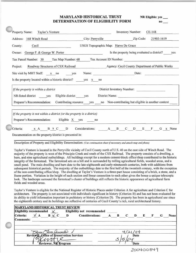
MARYLAND HISTORICAL TRUST NR Eligible: yes DETERMINATION OF ELIGIBILITY FORM no
Property Name: Taylor's Venture Inventory Number: CE-148
Address: 168 Winch Road City: Perryville Zip Code: 21903-1619
County: Cecil USGS Topographic Map: Harve De Grace
Owner: George F. & George W. Porter Is the property being evaluated a district? yes
Tax Parcel Number: 30 Tax Map Number: 68 Tax Account ID Number:
Project: Roadway Structures of CSX Railroad Agency: Cecil County Department of Public Works
Site visit by MHT Staff: x no yes Name: Date:
Is the property located within a historic district? yes x no
If the property is within a district District Inventory Number:
NR-listed district yes Eligible district yes District Name:
Preparer's Recommendation: Contributing resource yes no Non-contributing but eligible in another context
If the property is not within a district (or the property is a district)
Preparer's Recommendation: Eligible X yes no
^Criteria: x A B_x_C D Considerations: A B C D E F G x None
Documentation on the property/district is presented in:
Description o f Property and Eligibility Determination: (Use continuation sheet if necessary and attach map and photo)
Taylor's Venture is located in the Perryville vicinity of Cecil County north of U.S. 40 on the east side of Winch Road. The majority of the property is west of the Principio Creek and south of the CSX Railroad. The property consists of a dwelling, a barn, and nine agricultural outbuildings. All buildings except for a modern cement-block office/shop contributed to the historic integrity of the farmstead. The farmstead sets on a hill and is surrounded by rolling agricultural fields, wooded areas, and a small pond. The main dwelling and barn date to the late-eighteenth and early-nineteenth centuries, both with additions from subsequent historical periods. The majority of the outbuildings date to the first half of the twentieth century, with the exception of the non-contributing office/shop. The dwelling at Taylor's Venture is a three-part house consisting of a brick, a stone, and a frame portion. Variation in the height of each section and linear connection to each other gives the house a unique telescopic look. The landscape surround the farmstead's cluster of buildings still reflects the historic appearance of agricultural farm fields and wooded areas.
Taylor's Venture is eligible for the National Register of Historic Places under Criterion A for agriculture and Criterion C for architecture. The property is not associated with individuals significant in history (Criterion B) and has not been evaluated for its ability to yield information important in prehistory or history (Criterion D). The property has been in agricultural use since the eighteenth century and its buildings are reflective of centuries of Cecil County's rich, rural architectural history.
MARYLAND HISTORICAL TRUST REVIEW Eligibility recommended Eligibility not recommended Criteria: / A C D Considerations: A B C D E F G None Comments:
Review office of Preservation Services Date
Reviewer, program Date

MARYLAND HISTORICAL TRUST NR-ELIBILITY REVIEW FORM
Continuation Sheet No. 1
The property maintains its original location on the west bank of Principio Creek. The design of the largest portion of the dwelling exhibits a rural, vernacular interpretation of Federal architecture, particularly noticeable in the decorative detail of the original front door surround, windows, and dormers. Quality workmanship is evident in the brick and stone construction of the dwelling, as well as the stonework on the property's main barn. In addition, buildings on the property retain a high percentage of original materials, such as slate roofs and original wooden sash windows. As there is little modern development in the surrounding area and the majority of the property remains in productive agricultural use, the property's setting retains a high level of historic integrity. Taylor's Venture continues to impart a feeling of eighteenth, nineteenth, and early twentieth century agriculture. The property has no significant association with persons or events important in history.
Prepared by: Melissa Hess, KCI Technologies Date Prepared: February 9, 2004

CAPSULE SUMMARY Taylor's Venture (CE-148) 168 Winch Road Perryville vicinity c. 1800 Private
Taylor's Venture is located in the Perryville vicinity of Cecil County north of U.S. 40 on the east side of Winch Road. The majority of the property is west of the Principio Creek and south of the CSX Railroad. The farmstead sets on a hill and is surrounded by rolling agricultural fields, wooded areas, and a small pond. The property consists of a dwelling, a barn, and nine agricultural outbuildings. The dwelling and barn date to the late-eighteenth and early-nineteenth centuries, both with additions from subsequent historical periods. The majority of the outbuildings date to the first half of the twentieth century, with the exception of a non-contributing office/shop. The dwelling at Taylor's Venture is a three-part house consisting of a brick, a stone, and a frame portion. Variation in the height of each section and linear connection to each other gives the house a unique telescopic look. The landscape surround the farmstead's cluster of buildings still reflects its historic appearance of agricultural farm fields and wooded areas.
Taylor's Venture is eligible for the National Register of Historic Places under Criterion A for agriculture and Criterion C for architecture. The property has been in agricultural use since the eighteenth century and its buildings are reflective of centuries of Cecil County's rich, rural architectural history.
The seat of the Taylor family for generations, Taylor's Venture dates to the early eighteenth century. A 1720s map notes the area as "Thomas Taylor's Land." The first European ownership of this land was as part of a large patent granted to Irishman George Talbot in 1680 with the provision that he bring six hundred and forty persons of British or Irish descent to settle the area at his own expense. The name Taylor's Venture most likely originated with John Taylor, who deeded the property to his sons in the late 1790s. Members of the Taylor family continued to own the land until the mid-nineteenth century. Subsequent owners divided the land over the years. By the early twentieth century, the property was once again combined to its original acreage from three separate deeds. In the 1940s, owners restored the dwelling to its original colonial appearance.
Maryland Historical Trust Inventory No. CE-148
Maryland Inventory of Historic Properties Form
1. Name of Property (indicate preferred name)
historic Taylor's Venture
other The End of All Strife: Strife's End
2. Location street and number 168 Winch Road not for publication
city, town Perryville x_ vicinity
county Cecil
3. Owner of Property (give names and mailing addresses of all owners)
name George F. and George W. Porter
street and number 168 Winch Road telephone
city, town Perryville state MD zip code 21903-1619
4. Location of Legal Description courthouse, registry of deeds, etc. Cecil County Land Records liber 1352 folio 569
city, town Elkton tax map 30 tax parcel 68 tax ID number 07 009976
5. Primary Location of Additional Data Contributing Resource in National Register District Contributing Resource in Local Historic District Determined Eligible for the National Register/Maryland Register Determined Ineligible for the National Register/Maryland Register Recorded by HABS/HAER Historic Structure Report or Research Report at MHT Other:
6. Classification
Category Ownership Current Function Resource Count district public X agriculture landscape Contributing Noncontributing
X buildinq(s) X private commerce/trade recreation/culture 9 1 buildings structure both defense religion sites site domestic social structures object education transportation objects
funerary work in progress 9 1 Total government unknown health care vacant/not in use Number of Contributing Resources industry other: previously listed in the Inventory

7. Description Inventory No. CE-148
Condition
excellent deteriorated X good ruins
fair altered
Prepare both a one paragraph summary and a comprehensive description of the resource and its various elements as it exists today.
Taylor's Venture is located in the Perryville vicinity of Cecil County north of U.S. 40 on the east side of Winch Road. The majority of the property is west of the Principio Creek and south of the CSX Railroad. The property consists of a dwelling, a barn, and nine agricultural outbuildings. All buildings except for a modern cement-block office/shop contributed to the historic integrity of the farmstead. The farmstead sets on a hill and is surrounded by rolling agricultural fields, wooded areas, and a small pond. From Winch Road, a gravel lane lined with Cedar trees approaches the farmstead's cluster of historic buildings. The main dwelling and barn date to the late-eighteenth and early-nineteenth centuries, both with additions from subsequent historical periods. The majority of the outbuildings date to the first half of the twentieth century, with the exception of the non-contributing office/shop (Photographs 1-2).
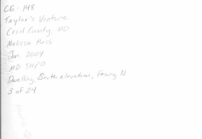
The dwelling at Taylor's Venture is a three-part house consisting of a brick, a stone, and a frame portion. Variation in the height of each section and linear connection to each other gives the house a unique telescopic look, particularly when viewed from the front facade, or south elevation (Photograph 3).
The largest portion of the dwelling is a two-and-one-half story, gabled roof, brick structure, three bays long and two bays deep, with two exterior end brick chimneys. This portion sits on a clearly visible stone foundation, as the basement is raised. The brickwork on all four elevations is common bond, though the brickwork on the front facade is of slightly higher quality workmanship than the other three sides. The windows of the front facade are wooden, six-over-six double hung sash windows topped with flat, brick arches and set on stone lintels. The wood paneled front door features a carved Federal-style door surround and a four-pane transom. The first story windows are missing their original shutters. The second story windows feature louvered wood shutters attached with decorative iron shutter stops. The slate-covered roof of this portion of the house features four Federal-style dormers (two on either side of the root) with wooden, double-hung sash windows. The west elevation has two false windows where an interior stair is placed. The rear facade, or north elevation, features a small, gable roof, partially-engaged, one-story porch with a wood pediment over the back door (Photographs 4-8).
The second portion of the house is also two-and-one-half stories and three bays wide, but only one bay deep and somewhat shorter in height than the brick portion of the house. This stone structure is the central portion of the house and possibly pre-dates the brick portion. It has a stone foundation, a slate-covered gable roof, and one exterior-end brick chimney. The stonework on the front facade (south elevation) features quoining and multi-colored stones. The front door is wood paneled and protected by a modern aluminum screen door. The windows on this portion are all wooden, six-over-six, double-hung sash windows. The front facade features a two-story, fully-engaged portico with slender, squared wood columns (Photograph 9-10).
Built in the first half of the twentieth century, the third portion of the house is a one-story frame structure that serves as a kitchen wing. This portion is two bays wide and one bay deep and has a slate gable roof, as well as a two-story, brick exterior-end chimney. The concrete foundation is scored to resemble stone. This portion is sided with weatherboard and also has wooden, six-over-six, double-hung sash windows. The rear facade, or north elevation, has a small wood portico over the wood paneled back door (Photographs 11-13).
As a whole, the three portions of the house represent distinct architectural periods and styles, displaying quality workmanship and a cohesive, balanced design (Photograph 14).
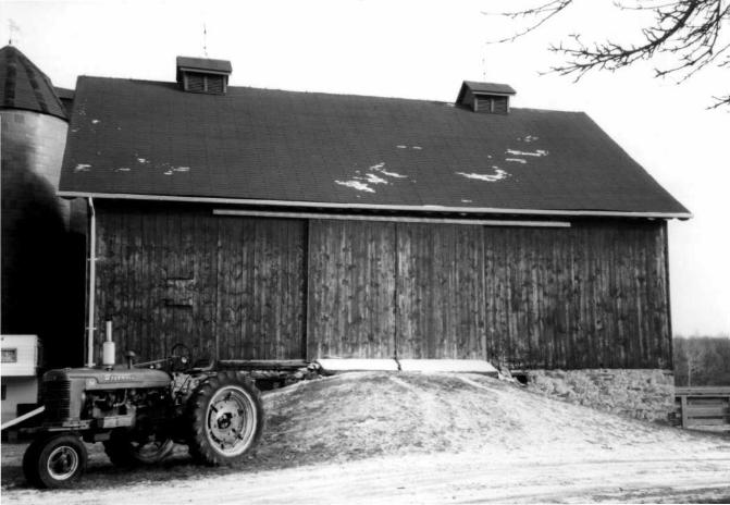
The property contains a Pennsylvania bank barn with a more recent, similar-sized structure attached to its northeast corner. The older section of the barn has a stone foundation, a wood-sided frame structure, and an asphalt-shingled gable roof. The stonework of the stable walls is similar to the stonework on the central portion of the dwelling. It also features an unenclosed forebay that extends over the stable yard. The barn roof has two gabled vents. The south elevation (gable end) has a Victorian-era scalloped, wooden vergeboard at the roofline. The newer portion is also frame and wood-sided with gabled rooftop vents, but has a concrete block foundation. Both sections of the barn are painted red. Near the point where the two segments of the barn are attached sets an orange-colored, tile silo with a conical, asphalt-shingled roof (Photograph 15-19). The property's outbuildings consist of several wood-
Maryland Historical Trust Maryland Inventory of inventory NO CE - 148 Historic Properties Form
Name Taylor's Venture Continuation Sheet
Number 7 Page 1
framed or concrete sheds of various sizes and uses. Other structures included a hand-pump and a concrete watering trough (Photographs 20-22).
The landscape surround the farmstead's cluster of buildings still reflects the historic appearance of agricultural farm fields and wooded areas. As there is little modern development in the surrounding area, Taylor's Venture continues to reflect centuries of Cecil County's agricultural heritage (Photographs 23-24).
8. Significance inventory NO. CE - 148
Period Areas of Significance Check and justify below
1600-1699 X agriculture economics health/medicine performing arts X 1700-1799 archeology education industry philosophy X 1800-1899 X architecture engineering invention politics/government
1900-1999 art entertainment/ landscape architecture religion 2000- commerce recreation law science
communications ethnic heritage literature social history community planning exploration/ maritime history transportation conservation settlement military other:
Specific dates Unknown Architect/Builder Unknown
Construction dates c. 1800
Evaluation for:
X National Register Maryland Register not evaluated
Prepare a one-paragraph summary statement of significance addressing applicable criteria, followed by a narrative discussion of the history of the resource and its context. (For compliance projects, complete evaluation on a DOE Form - see manual.)
Taylor's Venture is eligible for the National Register of Historic Places under Criterion A for agriculture and Criterion C for architecture. The property has been in agricultural use since the eighteenth century and its buildings are reflective of centuries of Cecil County's rich, rural architectural history.
The seat of the Taylor family for generations, the property known as "Taylor's Venture" dates to the early eighteenth century. A 1720s map notes the area as "Thomas Taylor's Land." The first European ownership of this land was as part of a large patent granted to Irishman George Talbot in 1680 with the provision that he bring six hundred and forty persons of British or Irish descent to settle the area at his own expense. Originally named "Susquehanna Manor," Talbot increased the patent, which was later named "New Connaught Manor," until it extended from the North East River to the Octoraro Creek and from the Chesapeake Bay to a point some miles north of the present boundary between Maryland and Pennsylvania.1
The name Taylor's Venture most likely originated with John Taylor, who deeded the property to his sons in the late 1790s. During the early 1800s, his son, Captain Thomas Taylor, lived at the property with his wife and ten children, many of whom are buried in a family cemetery on the property. Members of the Taylor family continued to own the land until the mid-nineteenth century.2
Subsequent owners divided the land over the years. Land records indicate that a Samuel Hughes received a deed for a 22 acre tract of land called "The End of All Strife," which included the present estate. By the early twentieth century, the property was once again combined under John E. Jackson's ownership from three separate deeds. In the 1940s, property owners Mr. And Mrs. Alfred C. Bohn, of New York, restored the property to its original colonial appearance. They called the estate "Strife's End," an abbreviation of "The End of All Strife." Since 1962, the Porter family has owned the property reverting to the original name "Taylor's Venture." 3
1 Morton Field Taylor, "A Historical Sketch of Taylor's Venture," The Upper Shoreman, Vol. 8 No. 8, 1970, p.3.
2Ibid.,p.2l.
3Ibid.,p.35.

9. Major Bibliographical References inventory NO. CE - 148 Blumgart, Pamela James et. al. At the Head of the Bay: A Cultural and Architectural History of Cecil County. Maryland.
Crownsville, MD: The Maryland Historical Trust Press, 1996.
Maryland Historical Trust. Historic American Building Survey Inventory. Strife's End or Taylor's Venture. 1968.
Taylor, Morton Field. "A Historical Sketch of Taylor's Venture." The Upper Shoreman Vol. 8 No. 8 (1970): 1, 3, 15, 21, 29, 35.
10. Geographical Data
Acreage of surveyed property 163 acres Acreage of historical setting 161 acres Quadrangle name Harve De Grace Quadrangle scale: 1:24.000
Verbal boundary description and justification
The boundary for the property is tax parcel 30 68. It is bound roughly by U.S. 40 to the south, Principio Creek to the east, and Winch Road to the west. The boundary encompasses the property's historic structures and includes surrounding agricultural fields, as they are reflective of the property's historic agricultural significance.
)
11. Form Prepared by
name/title Melissa Hess/Architectural Historian
organization KCI Technologies, Inc. date February 2004
street & number 5001 Louise Drive telephone 717-691-1340
city or town Mechanicsburg state PA
The Maryland Inventory of Historic Properties was officially created by an Act of the Maryland Legislature to be found in the Annotated Code of Maryland, Article 41, Section 181 KA, 1974 supplement.
The survey and inventory are being prepared for information and record purposes only and do not constitute any infringement of individual property rights.
return to: Maryland Historical Trust DHCD/DHCP 100 Community Place Crownsville, MD 21032-2023 410-514-7600


Taylor's Venture CE-148
Cecil County, Maryland
Taylor's Venture CE-148


Strife's End ( or Taylor's Venture) is a/reXescopic house of three parto-. The largest portion is a two -and-one -half— story brick structure, resembling a federal townhouse, three bays long and two bays deep. The brick is laid in common bond, and there are flat arches over the windows ©f^the south facade. There are two dormers -&a the roof. The northwest bays on the gable are false windows, undoubtedly where the stair is placed (as at Holly Hall and Mt. Ararat).
The second portion of the house is a three-bay one-room deep granite structure which may pre-da=fce the brick portion. The south facade has a center door, but the north door is located on the westernmest bay. There is a two-story porch in front of the stone section.
To the east of the stone house is a two-bay one-story frame wing which appears to be a recent addition.

Strife's End CE - 148 Taylor's Venture South Elevation MOB/1968 NEC - MD Hist. Trust