CCO PISO PAC-I 0 C - jodc.go.jp · IOC Workshop Report No.27 The Scientific Workshops of the...
59
Intergovernmental Oceanographic Commission Workshop report No. 27 CCO PISO PAC-I 0 C Second International Workshop on Geology, Mineral Resources and Geophysics of the South Pacific Noumea, New Caledonia, 9-1 5 October 1980 Unesco
Transcript of CCO PISO PAC-I 0 C - jodc.go.jp · IOC Workshop Report No.27 The Scientific Workshops of the...
Intergovernmental Oceanographic Commission Workshop report No. 27
CCO PISO PAC-I 0 C Second International Workshop on Geology, Mineral Resources and Geophysics of the South Pacific Noumea, N e w Caledonia, 9-1 5 October 1980
Unesco
INTERGOVERNMENTAL OCEANOGRAPHIC COMMISSION
,Workshop Report No.27
CCOP/SOPAC-IOC SECOND INTERNATIONAL WORKSHOP ON GEOLOGY, MINERAL RESOURCES AND GEOPHYSICS OF THE SOUTH PACIFIC
NoumQa, New Caledonia, 9-15 October 1980
SUMMARY REPORT

IOC Workshop Report No.27
The Scientific Workshops of the Intergovernmental Oceanographic Commission are usually jointly sponsored with other intergovernmental or non-governmental bodies. In each case, by mutual agreement, one of the sponsoring bodies assumes responsi- bility for publication of the final report. Copies may be requested from the publishing bodies as listed below or from Fontenoy, 75700 Paris, France.
No. Title
CCOP-IOC, 197\4, Metallogenesis, Hydrocarbons and Tectonic Patterns in Eastern Asia /Eeport of the I W E Workshop on7 ; Bangkok, Thailand, 24-29 September 1973. UNDP (CCOP), 138 pp.
CICAR Ichthyoplankton Workshop, Mexico City, 16-27 July 1974. (Unesco Technical Paper in Marine Sciences, No. 20) .
Report of the IOC/GFCM/ICSEM International Workshop on Marine Pollution in the Mediterranean, Monte Carlo, 9-14 September 1974.
Report of the workshop on the Phenomenon known as "El NiHo", Guayaquil, Ecuador, 4-12 December 1974.
IDOE International Workshop on Marine Geology and Geophysics of the Caribbean Region and its Resources, Kingston, Jamaica, 17-22 February 1975.
Reportofthe CCOP/SOPAC-IOC IDOE International Workshop on Geology, Mineral Resources and Geophysics of the South Pacific, Suva, Fiji, 1-6 September 1975.
Report of the Scientific Workshop to Initiate Planning for a Co- operative Investigation in the' North and Central Western Indian Ocean, organized within the IDOE under the sponsorship of IOC/FAO (IOFC)/Unesco/EAC, Nairobi, Kenya, 25 March-2 April 1976.
Joint IOC/FAO (IPFC) /UNEP Inter- national Workshop on Marine
the Secretary IOC, Unesco, Place de
Publishing Body
Office of the Project
UNDP/CCOP c/o ESCAP Sala Santitham Bangkok 2, Thailand
Manager
Pollution in East Asian Waters, Penang, 7-13 April 1976.
- 1 -
Division of Marine Sciences, Unesco
Place de Fontenoy 75700 Paris, France
IOC, Unesco Place de Fontenoy 75700 Paris, Franc,e
FAO Via delle Terne di
00100 Rome, Italy Caracalla
i
IOC, Unesco Place de Fontenoy 75700 Paris, France
IOC, Unesco Place de Fontenoy 75700 Paris, France
IOC, Unesco Place de Fontenoy 75700 Paris, France
IOC, Unesco Place de Fontenoy 75700 Paris, France
Languages
English
English 'Spanish
Eng 1 ish French Spanish
Eng 1 ish Spanish
English Spanish
Eng 1 ish
English (full text) Extract and Recomm'endations also in:
French Spanish Russian
English
IOC Workshop Report No. 27 Page 2
No.
9
-
10
11
11 Suppl.
12
Title Publishina Bodv Languages
IOC, Unesco Place de Fontenoy 75700 Paris, France
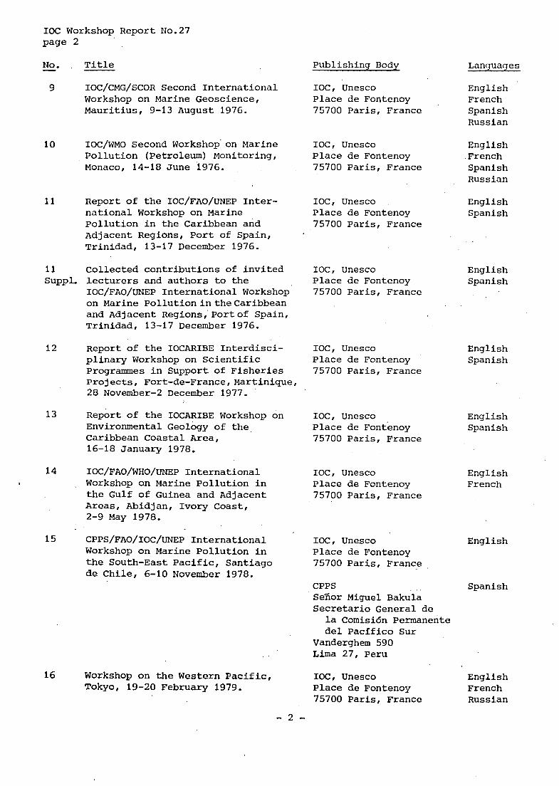
IOC/CMG/SCOR Second International Workshop on Marine Geoscience, Mauritius, 9-13 August 1976.
Eng 1 ish French Spanish Russian
IOC/WMO Second Workshop'on Marine Pollution (Petroleum) Monitoring, Monaco, 14-18 June 1976.
IOC, Unesco Place de Fontenoy 75700 Paris, France
English French Spanish Russian
Report of the IOC/FAO/UNEP Inter- national Workshop on Marine Pollution in the Caribbean and Adjacent Regions, Port of Spain, Trinidad, 13-17 December 1976.
IOC, Unesco Place de Fontenoy 75700 Paris, France
English Spanish
Collected contributions of invited lecturers and authors to the IOC/FAO/UNEP International Workshop on Marine PollutionintheCaribbean and Adjacent Regions,'Portof Spain, Trinidad, 13-17 December 1976.
IOC, Unesco Place de Fontenoy 75700 Paris, France
Eng 1 ish Spanish
Report of the IOCARIBE Interdisci- plinary Workshop on Scientific Programmes in Support of Fisheries Projects, Fort-de-France,Martinique, 28 November-2 December 1977.
IOC, Unesco Place de Fontenoy 75700 Paris, France
English Spanish
13
14
Report of the IOCARIBE Workshop on Environmental Geology of the Caribbean Coastal Area, 16-18 January 1978.
IOC, Unesco Place de Fontenoy 75700 Paris, France
English Spanish
IOC/FAO/WHO/UNEP International Workshop on Marine Pollution in the Gulf of Guinea and Adjacent Areas, Abidjan, Ivory Coast, 2-9 May 1978.
IOC, Unesco Place de Fontenoy 75700 Paris, France
English French
15
16
CPPS/FAO/IOC/UNEP International Workshop on Marine Pollution in the South-East Pacific, Santiago de Chile, 6-10 November 1978.
IOC, Unesco Place de Fontenoy 75700 Paris, France
English
CPPS . . SeTior Miguel Bakula Secretario General de
Spanish
la Comisi6n Permanente del Pacific0 Sur
Vanderghem 590 Lima 27, Peru
IOC, Unesco English Place de Fontenoy French 75700 Paris, France Russian
Workshop on the Western Pacific, Tokyo, 19-20 February 1979.
- 2 -

No.
17
-
17 Suppl.
18
19
20
Title
Joint IOC/WMO Workshop on Oceano- graphicproductsandthe IGOSSData Processing and Services System (IDPSS) , MOSCOW, 9-11 April 1979.
Papers submitted to the Joint IOC/WMO Seminar on Oceanographic Products and the IGOSS Data Processing and Services System, Moscow, 2-6 April 1979.
IOC/Unesco Workshop on Syllabus for Training Marine Technicians, Miami, 22-26 May 1978 (Unesco reportsinmarinesciences, No.4).
IOC Workshop on Marine Science Syllabus for Secondary Schools,. Llantwit Major, Wales, U.K., 5-9 June 1978 (Unesco reports in marine sciences, No. 5) .
Second CCOP-IOC Workshop on IDOE Studies of East Asia Tectonics and Resources, Bandung, Indonesia, 17-21 October 1978.
21 SecondIDOESymposiumonTurbulence in the Ocean, Liege, Belgium, 7-18 May 1979.
22 Third IOC/WMO WorkshoponMarine Pollution Monitoring,NewDelhi, 11-15 February 1980.
.
23 WESTPAC Workshoponthe Marine Geology and Geophysics of the North-West Pacific, Tokyo, 27-31 March 1980.
24 WESTPAC Workshop on Coastal Transport of Pollutants, Tokyo, 27-31 March 1980.
25 Workshopon the Intercalibrationof SamplingProceduresofthe IOC/WMO UNEP Pilot Project on Monitoring Background Levels of Selected Pollutants in Open-Ocean Waters, Bermuda, 11-26 January 1980.
IOC Workshop Report No.27 Page 3
Publishing Body
IOC, Unesco Place de Fontenoy 75700 Paris, France
IOC, Unesco Place de Fontenoy 75700 Paris, France
Division of Marine Sciences, Unesco
Place de Fontenoy 75700 Paris, France
Division of Marine Sciences, Unesco
Place de Fontenoy 75700 Paris, France
Office of the Project
UNDP/CCOP C/O ESCAP Sala Santitham Bangkok 2, Thailand
Manager
IOC, Unesco Place de Fontenoy 75700 Paris, France
IOC, Unesco Place de Fontenoy 75700 Paris, France
IOC, Unesco Place de Fontenoy 75700 Paris, France
IOC, Unesco Place de Fontenoy 75700 Paris, France
IOC, Unesco Place de Fontenoy 75700 Paris, France
Languages
English
E ng 1 ish
English French Spanish Russian
Eng 1 ish French Spanish Russian
English
English French Spanish Russian
Eng 1 ish French Spanish Russian
English Russian
English
English
- 3 -
IOC Workshop Report No.27 Page 4
No. t , Title - Publishing Body I Languaqcs
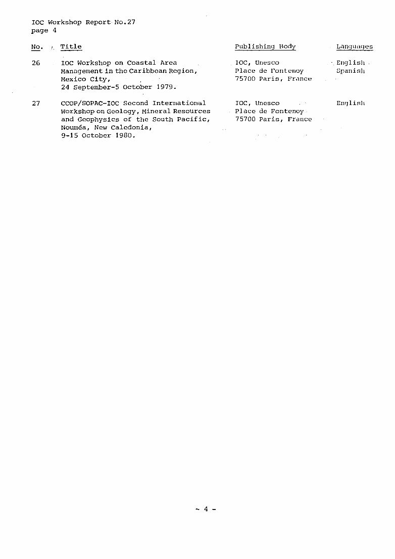
26 IOC Workshop on Coastal Area IOC, Unesco . English ManagementintheCaribbeanRegion, Place de Foritcrioy Spanisli Mexico City, 75700 Paris , France 24 September-5 October 1979.
27 CCOP/SOPAC-IOC Second International IOC, Unesco Encj 1 i sl I WorkshoponGeology, Mineral Resources and Geophysics of the South Pacific, 75700 Paris, France '
Noum6a, New Caledonia, 9-15 October 1980.
Place de Fontenoy
- 4 -

IOC. Workshop Report No. 27 Page 5
TABLE OF CONTENTS
Page
Preface. .................................... 6
Summary Report ................................. '7
, , , - ,
. . . Annexes 2 .
I - A g e n d a . . .............................. 11
13 I1 - List of participants .. ,
, . . I , I
I11 . Opening address by the High Commissioner . Mr. C. Charbonniaud . . . . 19
. .......................... IV Recommendations 21
V . Programmes of research ....................... 23
VI - List of scientific presentations ................... 47
VI1 - Subcommittee participants ..................... 51
VI11 - List of maps and publications on display ............... 53
IX - State of implementation of projects formulated in the 1975 Suva Workshop ........................ 57
- 5 -

IOC Workshop Report No.27 Page 6
The Workshop is jointly sponsored by the Intergovernmental Oceanographic Com- mission (of Unesco) and the Committee for Co-ordination of Joint Prospecting for Mineral Resources in South Pacific Offshore Areas, and will review and update the CCOP/SOPAC - IOC IDOE programme which was developed at the 1975 Workshop on the same subject (see IOC Workshop Report No.6). The terms of reference of this Work- shop in accordance to decision WESTPAC 1-9, are to:
1. summarize present knowledge and ongoing research projects on marine geo- sciences in the South-West Pacific;
2. identify major unsolved problems in the field of geology, geophysics, and mineral resources, and further research work needed to solve these problems;
define new scientific research and training programmes for execution in the region.
3.
- 6 -

IOC Workshop Report No.27 Page 7
SUMMARY REPORT
1. Opening of the Workshop and adoption of the agenda
The meeting was opened by His Excellency the High Commissioner of the Republic in the Pacific Ocean, Chief of the Territory of New Caledonia and Dependencies, Mr. C. Charbonniaud - his opening address is attached as Annex 111. The representa- tive of ICC, Dr. G. Giermann, Deputy Secretary of IOC, then welcomed the Workshop on behalf of the Dir&tor-General of Unesco and the Secretary IOC and thanked the French Government for its kind offer to host the Workshop in Noum6a. tive of ESCAP, Mr. L. Machesky, addressed the Workshop on behalf of the Executive Secretary of ESCAP. In his message, the Executive Secretary stressed the importance of close co-operation between the United Nations agencies and Member States for the benefit of the region. Mr. R. Richmond, who also served as Chairman of the,opening ceremony and by the Director of the ORSTOM Centre, Mr. de Boissezon, being the host of the Workshop. The opening ceremony was attended by representatives of the Government Council and the Territorial Assembly as well as by the Lord Mayor of Noumga. Scientists from the following 18 countries participated: Australia, Cook Islands, Fiji, France, Indonesia, Japan, Kiribati, Nauru, New Zealand, Papua New Guinea, Philippines, Solomon Islands, Tonga, United Kingdom, United States of America, Union of Soviet Socialist Republics, Vanuatu, Western Samoa.
2. Election of Chairman and Vice-chairman and nomination of rapporteurs
The representa-
Additional greetings were made by the Chairman of CCOP/SOPAC,
The Workshop elected Dr. S. Uyeda as Chairman of the Workshop and Mr.R.Richmond as Vice-chairman. Mr. A. Macfarlane and Mr. J. Dubois were appointed rapporteurs.
3. General review and background presentations
On behalf of the two sponsoring organizations, the IOC representative intro- duced the IOC resolution under which the Workshopwas established (decisionWESTPAC-1-91 and read out the Terms of Reference (as quoted in the Preface). The chairman then explained how the Workshop would be conducted. He stated that after a two-day re- view session (symposium) a two-and-a-half day Workshop would follow in which three Subcommittees would meet separately in order to update and refformulate programmes and projects. The last morning of the session would then be reserved for adoption of the Summary Report, the Subcommittee programmes and projects, and the general recommendations. The three Subcommittees were established as follows:
A.
B.
C.
Tectonic evolution of arcs and back-arc basins/Evolution tectonique des arcs et bassins arrigre-arc
(Chairman - P. Coleman) Deep crustal structure, petrogenesis and thermal rggime - evolution of the . lithosphere/Structure profonde de la croQte, p6trogenGse et r6gime thermique/ 6volution de la lithosphere
(Chairman - C.J. Allegre)
Stratigraphy, sedimentary provenance and metallogenesis/Stratigraphie, origine des sediments et meta1logenSs.e
(Chairman - J. Wright) A list of participants of the Subcommittees is attached as Annex VII. In the sym- posium held under this agenda item,'32 speakers presented overview papers and
- 7 -
IOC Workshop Report No.27 Page 8
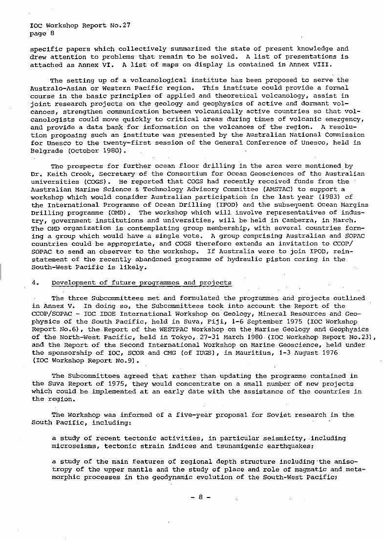
specific papers which collectively summarized the state of present knowledge and drew attention to problems that remain to be solved. A list of presentations is attached as Annex VI. A list of maps on display is contained in Annex VIII.
The setting up of a volcanological institute has been proposed to serve the Australo-Asian or Western Pacific region. This institute could provide a formal course in the basic principles of applied and theoretical volcanology, assist in joint research projects on the geology and geophysics of active and dormant vol- canoes, strengthen communication between volcanically active countries so that vol- canologists could move quickly to critical areas during times of volcanic emergency, and provide a data bank for information on the volcanoes of the region. tion proposing such an institute was presented by the Australian National Commission for Unesco to the twenty-first session of the General Conference of Unesco, held in Belgrade (October 1980).
A resolu-
The prospects for further ocean floor drilling in the area were mentioned by Dr. Keith Crook, Secretary of the Consortium for Ocean Geosciences of the Australian universities (COGS). He reported that COGS had recently received funds from the Australian Marine Science & Technology Advisory Committee (AMSTAC) to support a workshop which would consider Australian participation in the last year (1983) of the International Programme of Ocean Drilling (IPOD) and the subsequent Ocean Margins Drilling programme (OMD). The workshop which will involve representatives of indus- tryl government institutions and universities, will be held in Canberra, in March. The OMD Organization is contemplating group membership, with several countries form- ing a group which would have a single vote. A group comprising Australian and SOPAC countries could be appropriate, and COGS therefore extends an invitation to CCOP/ SOPAC to send an observer to the workshop. If Australia were to join IPOD, rein- statement of the recently abandoned programme of hydraulic piston coring in the South-West Pacific is likely.
4. Development of future programmes and projects
The three Subcommittees met and formulated the programmes and projects outlined in Annex V. In doing soI the Subcommittees took into account the Report of the CCOP/SOPAC - IOC IDOE International Workshop on Geology, Mineral Resources and Geo- physics of the South Pacific, held in Suva, Fiji, 1-6 September 1975 (IOC Workshop Report No.61, the Report of the WESTPAC Workshop on the Marine Geology and Geophysics of the North-West Pacific, held in Tokyo, 27-31 March 1980 (IOC Workshop Report N0.23)~ and the Report of the Second International Workshop on Marine Geoscience, held under the sponsorship of IOC, SCOR and CMG (of IUGS), in Mauritius, 1-3 August 1976 (IOC Workshop Report No.9).
The Subcommittees agreed that rather than updating the programme contained in the Suva Report of 1975, they would concentrate on a small number of new projects which could be implemented at an early date with the assistance of the countries in the region.
The Workshop was informed of a five-year proposal for Soviet research in the South Pacific, including:
a study of recent tectonic activities, in particular seismicity, -including microseisms, tectonic strain indices and tsunamigenic earthquakes;
a study of the main features of regional depth structure including.the aniso- tropy of the upper mantle and the study of place and role of magmatic and meta- morphic processes in the geodynamic evolution of the South-West Pacific;
- 8 -

IOC Workshop Report No.27 Page 9
a study of the main characteristic features of mineral resources distribution. A comprehensive study of magmatic and metamorphic rock associations of main regional structures and related endogenous mineralization. A survey of modern geosyncline sedimentation and ore formation in comparison with phanerozoic geo- syncline development. Investigations of sediment composition, their stratifi- cation types, ore content in different structural zones, at different distances from volcanoes and other active centres, a detailed study of hydrogenous and hydrothermal mineralization.
The future programmes and projects of research which were developed under this t
agenda item are attached to this report as Annex V; special recommendations are con- tained in Annex IV.
5. Adoption of the Summary Report including recommendations and new programmes
The Workshop adopted the Summary Report and the Annex IV (Recommendations) and v (Programmes of research) contained therein.
6. Closure of the Workshop
The meeting closed on Wednesday, 15 October, at noon. The participants ex- pressed their appreciation to the organizers of the Workshop for their excellent arrangements and their generous hospitality.
- 9 -

IOC Workshop Report No.27 Annex I - page 1
ANNEX I
AGENDA
1. Opening of the Workshop and adoption of the agenda
2.
3. General review and background presentations
Election of Chairman and Vice-chairman and nomination of rapporteurs
4. Development of future programmes and projects
5. Adoption of the Summary Report including recommendations and new programmes
6. closure of the Workshop.
- 1 1 -
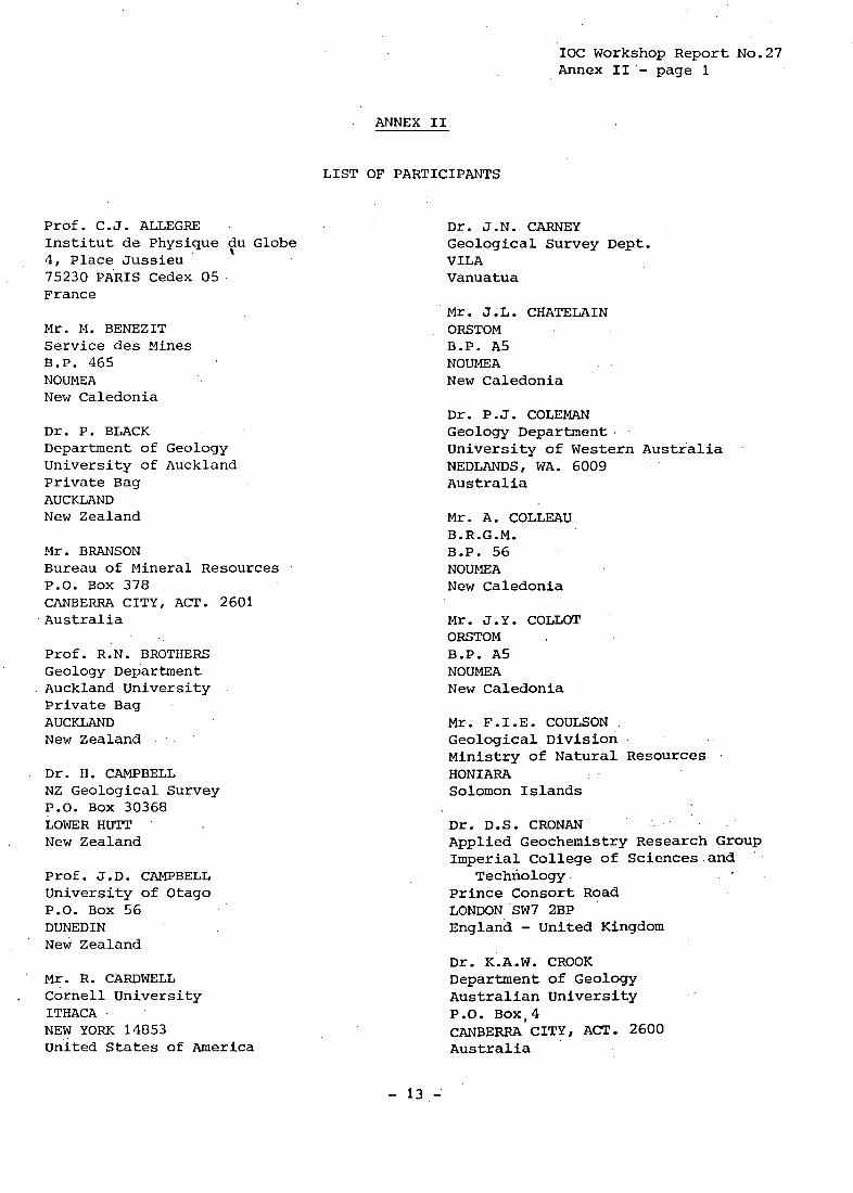
IOC Workshop Report No.27 Annex 11'- page 1
ANNEX I1
Prof. C. J. ALLEGE Institut de Physique tu Globe 4, Place Jussieu . .
75230 PARIS Cedex 05 France
Mr. M. BENEZIT Service des Mines B.P. 465 NOUMEA New Caledonia
Dr. P. BLACK Department of Geology University of Auckland Private Bag AUCKLAND New Zealand
Mr. BRANSON Bureau of Mineral Resources P.O. Box 378 CANBERRA CITY, ACT. 2601 Australia
Prof. R.N. BROTHERS Geology Department Auckland University Private Bag AUCKLAND New Zealand
Dr. H. CAMPBELL NZ Geological Survey P.O. Box 30368 LOWER HUTT New Zealand
Prof. J.D. CAMPBELL University of Otago P.O. Box 56 DUNEDIN New Zealand
' Mr. R. CARDWELL ~ Cornell University
ITHACA I
NEW YORK 14853 United States of America
LIST OF PARTICIPANTS
Dr. J.N. CARNEY Geological Survey Dept. VILA Vanuatua
Mr. J.L. CHATELAIN ORSTOM B.P. A5 NOUMEA New Caledonia
Dr. P.J. COLEMAN Geology Department University of Western Australia NEDLANDS, WA. 6009 Australia
Mr. A. COLLEAU B.R.G.M. B.P. 56 NOUMEA New Caledonia
Mr. J.Y. COLLOT ORSTOM B.P. A5 NOUMEA New Caledonia
Mr. F.I.E. COULSON Geological Division Ministry of Natural Resources HONIARA Solomon Islands
Dr. D.S. CRONAN Applied Geochemistry Research Group Imperial College of Sciences and
Prince Consort Road LONDON SW7 2BP England - United Kingdom
Technology
Dr. K.A.W. CROOK Department of Geology Australian University P.O. Box,4 CANBERRA CITY, ACT. 2600 Australia
- 13 -
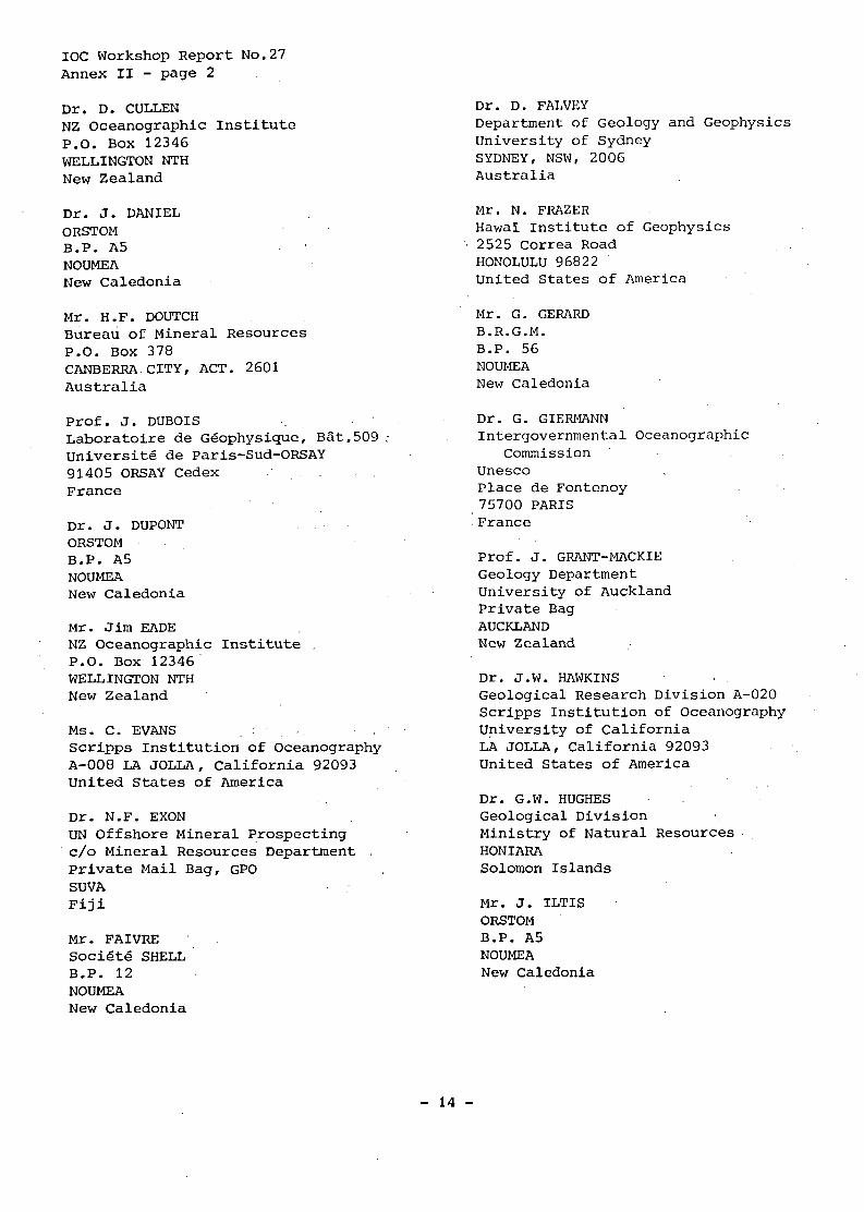
IOC Workshop Report No.27 Annex I1 - page 2 Dr. D. CULLEN NZ Oceanographic Institute P.O. Box 12346 WELLINGTON NTH New Zealand
Dr. J. DANIEL ORSTOM B.P. A5 NOUMEA New Caledonia
Mr. H.F. DOUTCH Bureau of Mineral Resources P.O. Box 378 CANBERRA CITY, ACT. 2601 Au s t ra 1 ia
Prof. J. DUBOIS Laboratoire de Ggophysique, BSt.509 : Universite de Paris-Sud-ORSAY 91405 ORSAY Cedex France
Dr. J. DUPONT OkSTOM B.P. A5 NOUMEA New Caledonia
Mr. Jim EADE NZ Oceanographic Institute P.O. Box 12346' WELLINGTON NTH New Zealand
Ms. C. EVANS Scripps Institution of Oceanography A-008 LA JOLLA, California 92093 United States of America
Dr. N.F. EXON UN Offshore Mineral Prospecting c/o Mineral Resources Department Private Mail Bag, GPO SUVA Fiji
Mr. FAIVRE: SociCitfS SHELL B.P. 12 NOUMEA New Caledonia
Dr. D. FALVEY Department of Geology and Geophysics University of Sydney SYDNEY, NSW, 2006 Australia
Mr. N. FRAZER Hawai Institute of Geophysics 2525 Correa Road HONOLULU 96822 United States of America
Mr. G. GERARD B.R.G.M. B.P. 56 NOUMEA New Caledonia
Dr. G. GIERMANN Intergovernmental Oceanographic
Commission unesco Place de Fontenoy 75700 PARIS France
Prof. J. GRANT-MACKIE Geology Department University of Auckland Private Bag AUCKLAND New Zealand
Dr. J.W. HAWKINS Geological Research Division A-020 Scripps Institution of Oceanography University of California LA JOLLA, California 92093 United States of America
Dr. G.W. HUGHES Geological Division Ministry of Natural Resources HONIARA Solomon Islands
Mr. J. ILTIS ORSTOM B.P. A5 NOUMEA New Caledonia
- 14 -

IOC workshop Report No.27 Annex I1 - page 3
Mr. P. JEGAT Service des Mines B.P. 465 NOUMEA New Caledonia
Dr. R.W. JOHNSON Bureau of Mineral Resources P.O. BOX 378 CANBERRA CITY, ACT. 2601 Australia
\
Dr. C. JOUANNIC CCOP/SOPAC Mineral Resources Department Private Mail Bag, GPO S W A Fiji
Dr. H.R. KATZ New Zealand Geological Survey P.O. Box 30368 LOWER HUTT New Zealand
Dr. L.W. KROENKE UN Offshore Mineral Prospecting Mineral Resources Department Private Mail Bag, GPO SUVA Fiji
Dr. K. LAMBECK Research School of Earth Sciences Australian National University P.O. Box 4 CANBERRA, ACT. 2600 Australia
Mr. A. LAPOUILLE ORSTOM B.P. A5 NOUMEA New Caledonia
Mr. B.G. LOPATIN Sevmorgeo USSR LENINGRAD MOYKA 120 Union of Soviet Socialist Republics
Dr. B.M. LARUE ORSTOM B.P. A5 NOUMEA New Caledonia
Mr. R.G. LITTLEFIELD Phi 11 ips Petroleum Company 266 FPB 1 BARTLESVILLE Oklahoma 74004 United States of America
Mr. L.F. MACHESKY Economic Affairs Officer Mineral Resources Section ESCAP The United Nations Building Rajadamnern Avenue BANGKOK Thai land
Mr. A. MACFARLANE Geological Survey Department VILA Vanuatu
Dr. G. MCMURTRY Hawaii Institute of Geophysics University of Hawaii 2525 Correa Road HONOLULU, Hawaii 96822 United States of America '.
Dr. A. MALAHOFF National Ocean Survey/NOAA 6001 Executive Boulevard ROCKVILLE Maryland 20852 Attn. Cx4 United States of America
Mr. C. MATOS UN Offshore Mineral Prospecting Mineral Resources Department Private Mail Bag, GPO S W A Fiji
Mr. P. MAURIZOT B.R.G.M. ,
B.P. 56 NOUMEA New Caledonia
Mr. B. MICHEL S.L.N. B.P. E5 NOUMEA New Caledonia
- 15 -
1% Workshop Report No.27 Annex I1 - page 4 Mr. P. MILLIARD Cie. GQnQrale des Minerais Caledoniens 21-23, rue de 1'Alma NOUMEA New Caledonia
Mr. F. MISSEGUE ORSTOM B.P. A5 NOUMEA New Caledonia
Mr. S.T.S. NION Geological Survey of Papua
P.O. Box 778 New Guinea
. PORT-MORESBY
Mr. T. OTANG Ministry of Natural Resources
Development P.O. Box 261 Bikenibeu - TARAWA Kiribati
Prof. G. PACKHAM Department of Geology and Geophysics University of Sydney SYDNEY, NSW 2006 Australia
Mr. S.N. PADMONEGORO Consulat de la Rgpublique d'IndonrSsie NOUMEA New Caledonia
Mr. J.P. PARIS B.R.G.M. B.P. 56 NOUMEA New Caledonia
Mr. C.B. PITRE Service de GBologie Societe Metallurgique Le Nickel B.P. E5 NOUMEA New Caledonia
Mr. P. PODVIN B.R.G.M. B.P., 56 NOUMEA New Caledonia
-'16 -
Mr. B. PONTOISE ORSTOM B.P. A5 NOUMEA New Caledonia
Mr. M. RABINOVITCH S.L.N. B.P. E5 NOUMEA New Caledonia
Mr. B. RA0 Department of Geology and Mineralogy University of Queensland St. Lucia BRISBANE, 0, 4067 Australia
Dr. C. RAVENNE Institut FranFais du PBtrole B.P. 311 92506 RUEIL-MALMAISON Cedex France
Dr. J. RECY ORSTOM B.P. A5 NOUMEA New Caledonia
Mr. R. N. RICHMOND Mineral Resources Department Private Mail Bag, GPO I
S-WA Fiji
Mr. R.S. RIEZA PNOC Exploration Corporation P.O. Box 1208 Makati Commercial Center Makati METRO MANILA Phi 1 ipp ine s
Dr. J.L. SAOS Mineral Resources Department B.P. 637 VILA Vanuatu '
Mr. J. SCHEIBLER INCO - OcrSanie B.P. 218 NOUMEA New Caledonia

IOC Workshop Report No.27 Annex I1 - page 5
Mr. D. SECHER Laboratoire de Tectonophysique 2, Chemin de la HoussiniGre NANTES France
Dr. N.J. SKINNER University of the South Pacific P.O. Box 1168 SUVA Fiji
Mr. R.A.B. SUKAMTO Geological Research and
Development Centre JL Diponegoro 57 BANDUNG Indonesia
Dr. J. TALANDIER Laboratoire de GGophysique, Commissariat
B.P. 640 PAPEETE Tahiti
Dr. M.J. TERMAN Chief, Branch of Middle Eastern and
US Geological Survey National Centre (917) RESTON, Virginia 22092 United States of America
a 1 ' Energie Atomique
Asian Geology
Mr. S.L. TONGILAVA Ministry of Lands, Survey and
P.O. Box 5 NUKU ' ALOFA Tonga
Natural Resources
Mr. A. UTANGA Ministry of Works, Survey and
Department of Survey P.O. Box 114 RAROTONGA Cook Islands
Electricity
Dr. S. UYEDA Earthquake Research Institute University of Tokyo No.1-1, Yayoi 1-chome Bunkyo- ku TOKYO 113 Japan
Mr. A. WANTIEZ Cie. des Minerais Calgdoniens Etablissements BALLANDE B.P. C4 NOUMEA New Caledonia
Dr. J.K. WEISSEL Lamont-Doherty Geological Observatory PALISADES, N.Y. 10964 United Stat& of America
Mr. J.B. WILLCOX Bureau of Mineral Resources P.O. Box 378
Australia CANBERRA CITY, ACT. 2601
Mr . E .F . WINTERSTEIN APIA Observatory Department of Agriculture P.O. Box 52 APIA Western Samoa
Mr. J. WRIGHT Institute of Geological Sciences Ring Road HALTON Leeds LS15 8TQ United Kingdom
I
Mr. K. YOKOYAMA Geology Department Auckland University Private Bag AUCKLAND New Zealand
Dr. N. YONEKURA Department of Geography University of Tokyo 7-3-1, Hongo, Bunkyo-ku TOKYO Japan 113
Dr. y.V. ZDOROVENIN Institute of Earth's Physics USSR Academy of Sciences ~
B. Gruzinskaya 10 MOSCOW 1 23 8 1 0 Union of Soviet Socialist Republics
- 17 -

IOC Workshop Report No.27 A M e X I1 - page 6 Mr. B.X. ZHANG Chief Natural Resources Division .
ESCAP The United Nations Building Rajadamnern Avenue BANGKOK 2 Thai land
- 18 -
IOC Workshop Report No.27 Annex I11 - page 1
ANNEX I11
Address by
Mr. C. Charbonniaud High Commissioner of the Republic in the Pacific Ocean, Chief of the Territory of New Caledonia and Dependencies
On behalf of the Government of the French Republic, I am particularly happy to welcome the officials in charge of the technical departments of various countries and territories in the Pacific, and eminent scientists who in some cases have come a much greater distance, to this second Workshop organized jointly by the Committee for Co-ordination of Joint Prospecting for Mineral Resources in South Pacific Off- shore Areas and the Intergovernmental Oceanographic Commission. As Chief of the Territory, I am glad that it has been possible to hold this meeting in New Caledonia at the ORSTOM Centre in Noumea, whose teams of geologists and geophysicists have con- tributed to a greater knowledge of the South Pacific.
The peoples of the South Pacific have realized that the energy resources and
They have great hopes raw ma’terials of the land masses are limited or will rapidly be exhausted. have turned their attention to the vast ocean around them. of it - perhaps unduly great! But the scientists taking part in the exploration of the South Pacific are not yet in possession of enough reliable knowledge to encour- age their hopes or to dispel their dreams.
They
I might mention that the South Pacific has been left relatively untouched in recent years by major scientific programmes, and, in particular, no IPOD drilling has been carried out there for some time. Oceanographic expeditions organized by bodies outside the South Pacific seem to have been less numerous than previously. I do not think that this is due either to lack of scientific interest in the region or to lack of interest in its potential; but our maritime zones are far from the large countries which can afford to promote such research, and the economic crisis has, without a doubt, caused them to revise their priorities. Furthermore, the size of the maritime zones to be explored is out of all proportion to the funds ht the disposal of the countries and territories of the South Pacific.
It is therefore particularly important that, acting through international organizations such as the Committee for Co-ordination of Joint Prospecting for Mineral Resources in South Pacific Offshore Areas and the Intergovernmental Oceano- graphic Commission of Unesco, we should be able to pool our efforts and even our funds in order to extract maximum benefit from national programmes or to co-operate in carrying out exploration programmes. In this connection, I am able to state on behalf of the government that France intends to continue to offer the services.of its scientists and, as far as possible, its nautical facilities, as it has already done both in the past and very recently off the coast of Vanuatu.
You have met, then, to assess what has been learned and to devise research pro- grammes which, in the years to come, will help us to advance our knowledge of sub- marine resources in the South Pacific and subsequently to make use ofthoseresources. I hope that these programmes may further the advance of science, but, above all, I hope that any mineral resources that you may be able to detect will contribute to development and to a better quality of life for all the inhabitants of this region.
- 19 -

IOC Workshop Report No.27 Annex I11 - page 2
Ladies and gentlemen, in welcoming you to the Territory of New Caledonia, I should like to express my sincere hope that your proceedings and discussions may be fruitful and that your present and future research may provide the peoples of the South Pacific with reliable knowledge of the mineral resources oftheirvast ocean domain.
- 20 -

IOC Workshop Report No.27 Annex IV - page 1
ANNEX IV
FG3COEIMENDATIONS
The Second CCOP/SOPAC - IOC International Workshop on Geology, Mineral Resources and Geophysics of the South Pacific,
1.
2.
3.
4.
Recommends thattthe Chairman of the Workshop transmit for approval the adopted Summary Report of the Workshop (including recommendations and programmes of research) to the next session of CCOP/SOPAC, to be held in Tarawa, Kiribati, 20-28 October 1980, and to the Secretary of IOC for submission to the next session of the IOC Executive Council, to be held in May or June 1981 in Spain,' as well as to the next session of the Programme Group for the Western Pacific (WESTPAC), to be held in Jakarta, September 1981;
Recommends that, Unesco and its IOC, CCOP/SOPAC and ESCAP provide immediate training in marine geology, geophysics and mineral resources as well as in data handling, so as to avoid delays in the implementation of the programmes of research;
Recommends that Unesco arrange for a meeting of operators of seismographic networks with interested representatives of island groups, in order to discuss: (1) the improvement of communication between existing networks and the estab- lishment of a regular exchange of seismographic bulletins; (2) the exchange of technical information on instrumentation; and (3) the establishment of new net- works in critical areas;
Recommends that Unesco and its IOC examine and improve;as a matter of priority, the co-ordination and interpretation of the seismic information system in Vanuatu, Fiji, Samoa and Tonga, and tsunami warning communication system in the region.
- 21 -

IOC Workshop Report No.27 Annex V - page 1
ANNEX V
PROGRAMMES OF RESEARCH
I. Report of Subcommittee A on tectonic evolution of arcs and back-arc basins
Introduction
The CCOP/SOPAC region is a key area for studying a wide range of fundamental problems, many of which are closely connected with assessments of'hydrocarbon and mineral resources potential, and geological hazards.
Elucidation of the crustal history of the region, which among other things will require integration of marine and land-derived stratigraphic and geophysical data, is an essential component in the assessment of the mineral and hydrocarbon resource potential of the region. Consequently the research projects treated be- low have been examined from a conjoint perspective in which relevance to fundamental scientific problems and relevance to resource assessments are integrated.
The region affords excellent examples of many important tectonic geomorphic and sedimentary features associated with the active margins of oceanic plates. These include: the active volcanic island arcs and their associated trenches which characterize the zones of plate convergence along the Melanesian Borderland and Tonga-Kermadec chain; fossil convergence zones such as the Fiji Platform; actively extending and inactive marginal basins with passive, oblique-slip, and active trench margins; active and inactive interarc basins diverse in size and sedimentary fill; and regions where the polarity of subduction may have been reversed following the collision of an oceanic plateau with a trench.
Each of these features displays considerable internai variation. For example, the active trenches vary in depth along their lengths. In three instances, this variation is due to the presence of ridges on the oceanic crust which is being con- sumed at the trench. The Woodlark Rise, an active spreading centre. is being con- sumed at a high angle beneath New Georgia, interrupting the Solomons Trench. An inactive ridge, the d'Entrecasteaux Fracture Zone, is being consumed orthogonally beneath Espiritu Santo, interrupting the New Hebrides Trench. The inactive Louisville Ridge, which is being consumed obliquely at the Tonga-Kermadec Trench, has swept southwards along the trench during the past few million years thereby contributing to morphological contrasts between the fore-arc regions in the Tonga and Kermadec segments of the Tonga-Kermadec arc.
Convergent margins in the region vary greatly in. their vectors of motion.rela- tive to the earth's mantle. account for the tectonic and geomorphic diversity within the region, and related variations in seismicity, volcanicity and heat flow.
This feature of the region's lithosphere dynamics may
Geological and geophysical data attest to the dynamic nature of the region throughout the Cenozoic. Work undertaken since the First CCOP/SOPAC Workshop in 1975 shows that this history involves large lateral rotations of crustal blocks, such as Vanuatu and Fiji which rotated in opposite senses: and substantial vertical movements, with late Quaternary rates as high as 5m/1,000 years in parts of Vanuatu and New Zealand.
The history of crustal evolution in the region is complex.
- 23 -

IOC Workshop Report No.27 Annex V - page 2
The thermal, deformational and geomorphic consequences of this dynamic history are particularly relevant to sedimentary basins in the region, such as the Central Solomons Trough, which are prospective for hydrocarbons.
The 1975 CCOP/SOPAC Workshop proposed a number of research projects that fall within the purview of Committee A. Other projects were commended to this Workshop by the WESTPAC Workshop held in Tokyo, in March 1980. Substantial progress has been made on some of these projects, for example, Field Project 1-2: Study of the North Fiji Basin. Essential preliminary studies have been completed on other pro- jects. For example, site surveys of the Tonga-Lau Transect (Field Project 2-6) have been made by ORSTOM. Compilation of this project depends upon future work in the region under the aegis of IPOD or the Ocean Margin Drilling programme (OMD). Other projects, such as the study of the Solomon and Woodlark Basins (Field Pro- ject 1-3), remain virtually untouched.
The present status of each of the previously proposed projects is tabulated in an appendix to this report. The CCOP/SOPAC meeting in Kiribati may wish to comment on this summary, and the WESTPAC recommendations, in the light of scientific, tech- nological and economic developments which have occurred since the projects were originally proposed.
Project A-1 - Study of island arc sedimentary basins; correlation of reference sections and seismic stratigraphy
The geological history of island sedimentary basins is of fundamental import- ance to the study of island arc tectonics, their resource evaluation and geological hazards assessment detailed age, lithological and thickness data from sedimentary reference sections on the islands are vital to the recognition and understanding of offshore seismic reflection and refraction profiles. In particular, thickness and lithology observed in outcrops are the data to be used for comparison with velocity parameters obtained from refraction work offshore, as well as, where possible, on land (e.g. Guadalcanal Plains). These velocity parameters will also define total sedimentary thickness and basement.
The purpose of this project is to provide basic stratigraphic and structural data to assist in the preliminary assessment of hydrocarbon potential and seismic hazards. This can be accomplished by detailed marine geophysical surveys including the collection of single and multi-channel seismic reflection, gravity and magnetic data, along with the land studies.
’
Such investigations are recommended in the island arcs of Manus - New Ireland, Bougainville, the Solomons, Vanuatu, Fiji and Tonga, where detailed stratigraphic sections can be evaluated.
1. In the Manus - New Ireland region, the Miocene Lauis formation and the Mio- Pliocene Rambutyo Beds may occur in offshore wrench fault basins.
2. The mid-Tertiary sequence of Western Bougainville should be correlated with the Etoile-1 Well section.
3. In the Solomon Islands, the detailed data available from the Shortland Group, Choiseul and New Georgia Islands would usefully serve as a control for the Oligocene to Pleistocene stratigraphy in the northwestern Central Solomons Trough. Likewise, the detailed data of the Late Cretaceous to Pleistocene sequence in southernMalaita, Nggela and Guadalcanal would assist interpretation in the south- eastern part of the same basin.
- 24 -
IOC-Workshop Report No.27 Annex V - page 3
Lithological data from Rennell Island Miocene and Pleistocene limestones may assist in the interpretation of future seismic surveys in that region.
The Middle Miocene to Pleistocene sequence of NendB Island in the Santa Cruz Group may usefully be correlated with sequences in nearby offshore basins, such as the North Fiji Basin and the northern New Hebrides Basin.
' 4. In Vanuatu, detailed data on the Miocene and Pliocene sediments of Espiritu Santo and Malekula Islands, together with the Mio-Pliocene sediments on Maewo and Pentecost Islands will assist the interpretation of seismic profiles in the adjacent Central Basin.
5. In the Fiji region, detailed work on the Miocene-Pliocene sedimentary basins of western Viti Levu, especially stratigraphic, and thickness relationships between the Wainimala and younger formations would assist correlation of offshore seismic studies with land data.
6. In Tonga, the Eocene-Oligocene and 14iocene sequence of 'Eua, the Miocene sections exposed on various islands of the Nomuka Group, and the probable Pliocene limestones of Vava'u should be studied and presented in detail, to assist offshore seismic interpretation.
Recommendations
(1) For the success of Project A-1, the geological surveys of the re_spective island countries should produce bio- and litho-stratigraphic columns and correlations be- ' tween adjacent islands. (50-100 m) on land for stratigraphic section compilation, heat flow measurements determination of physical properties and to obtain samples for source rock analyses.
(2) Detailed high quality marine geophysical data (single channel s.eismic, seismic refraction, gravity, magnetics and bathymetry) should be collected in the key pros- pective areas of the Melanesian Borderlands. In addition, high frequency, true amplitude multi-channel seismic data should be collected to elucidate basin seismic stratigraphy, subsidence history, structure and tectonics, initially in the Central Solomons Trough and the Central Basin of Vanuatu.
(3) and New Ireland, along the eastern and possibly southwestern limits of the Central Solomons Trough and also the Central Basin of Vanuatu should be investigated in detail. The results of this investigation should be related to the ESCAP Sedimen- tary Basins Correlations Project (IGCP Project No.32) .
This study should be combined with shallow drilling
The presence of broad wrench fault zones such as those suspected between Manus
Project A-2 - Solomon Islands palaeomagnetic project Palaeomagnetic studies have been carried out in Tonga, Fiji, Vanuatu and Papua
New Guinea over the last four years following the recommendations of the previous Workshop. Arc rotations demonstrated by these data, together with the sea-floor magnetics, provide an essential basis for Tertiary palaeotectonic and palaeogeo- graphic reconstructions. The understanding of the geotectonic history of a region is a necessary prerequisite for hydrocarbon exploration and a desirable adjunct to mineral exploration.
. Whether or not the polarity of the northern side of the Melanesian arc reversed in the Miocene is one of the more important unresolved problems of the tectonics of
- 25 -

IOC Workshop Report No.27 Annex V - page 4 the arc complex. It has been suggested that the island of Malaita is part of a flake of the Ontong Java Plateau, thrust across the blocked subduction zone. The motion of the Pacific plate with respect to the asthenosphere in the northern Melanesian region is approximately westwards, and that of the Indian plate north- wards. Because of these contrasting motions, palaeomagnetic studies on well-dated rocks on Malaita and other islands of the group should indicate their plate associa- tions and the timing of any relocations of plate boundaries.
The Solomon Island arc may have originated on,the Indian/Australian plate, or alternatively on the Pacific plate remote from the present plate boundary region. Palaeomagnetic studies of Palaeogene and Late Cretaceous rocks may resolve this question.
Another fundamental problem concerns the degree of integrity of an island arc during a back-arc or marginal basin sea-floor spreading episode. Miocene and Plio- cene palaeomagnetic data from Vanuatu have strongly suggested integral arc rotation from six million years ago. Miocene and Pliocene rocks also occur in the Santa Cruz Islands. Since these are part of the New Hebrides island arc palaeomagnetic sampling on Santa Cruz Islands should resolve the style of arc rotation. Confirma- tion ofethe presumed tectonics of the remnant arc ("Vityaz Arc") should be gained by palaeomagnetic sampling of Fatutaka (Mitral Anuta and adjacent eastern Solomon Islands.
Recommendations
(1) A detailed palaeomagnetic survey including magnetostratigraphic studies should be carried out on the islands of Malaita and Guadalcanal in the Solomon Islands. Some sampling may also be necessary on Nggela, San Cristobal and Santa Isabel.
(2) A palaeomagnetic survey should be carried out on the eastern Solomon Islands.
Project A-3 - Definition of Indian Pacific plate boundary north of Fiji Most of the tectonic lineations along the SouthTWest Pacific reflect the
present and former plate boundaries between the Indian and Pacific plates. It is important to delineate the position of the present plate boundaries between the Pacific and Indian plates and between the plates and the marginal basins, both'for scientific reasons and the assessment of earthquake hazards.
The plate boundary between the North Fiji Basin, the Lau Basin and the Pacific plate is poorly defined, especially in the region north of Fiji where there appears to be a complex zone between the two marginal basins and the Pacific plate.
It is recommended that the data collected since 1970 on earthquake activity in the North Fiji - Lau Basins area be re-examined. be made together with relocation of foci using lithospheric seismic velocities ob- tained from recent refraction studies., . .
First motion determinations should
. . . .
I . . ,
Accuracy of.locations should also'be improved by the installation of seismic stations on islands of the region such as Wallis,,Futuna, ROtuma and Nia'foou. Towards this end the Committee also strongly recommends that the complementary tele- metered seismic network in Fiji be improved by the provision through aid sources of an on-line computer for interpretation of data (cf. rec. in Annex IV). .
. .
. 8 . I , % I .
- 26 -
IOC Workshop'Report No.27 Annex V - page 5
Target areas for plate boundaries studies should be selected from analysis of the seismic data and from the examination of magnetic anomalies located over the North Fiji and Lau Basins. These areas would be best located along active ridge sections and fracture zones and their intersections. Seismic and microseismic activity of the target areas should then be examined through the shipboard deploy- ment of ocean bottom seismic arrays across and along these active tectonic features.
The geologic structure of Wallis and Futuna Islands should be compared with that of Hunter, Matthew and Kandavu. settings.
These all appear to have similar structural
These studies should provide a precise definition of the marginal basin/Pacific plate boundary and a better assessment of the earthquake hazards and kinematic history of this region.
. I
The subduction 'of an active spreading system at an oceanic island arcrtrench I system is a significant tectonic occurrence. In the southwestern Pacific this situation is occurring today, where the Woodlark spreading system (of post-Miocene age) is being subducted beneath the New Georgia Islands section of the Solomon Island arc. The Woodlark Basin - Solomon Islands region thus provides: (a) unique opportunity to study the geophysical and geochemical effects of oblique sub- duction of an active oceanic spreading system at an intra-oceanic island arc; and (b) a natural laboratory in which the roles of sediment and altered oceanic crust in island arc magma genesis can be determined. study of this region with the following objectives:
We therefore propose an integrated
(1) To ascertain the geochemistry of both the incoming (Woodlark Basin) crust and sediments and the voluminous Plio-Pleistocene subaerial and submarine lavas erupted in and around the New Georgia Islands,.
To determine the present heat flow regime in that part of *e Solomon Island-arc where the Woodlark spreading system is being subductegc,
To determine the ages of the main rock associations of the New Georgia group.
To undertake a comparative study of the post-Pliocene vertical tectonics of the New Georgia group and the adjacent islands of the Solomons arc and hence to investigate possible links between subduction of buoyant Woodlark Basin crust and such vertical movements.
(2) - - _- - -____-
(3)
(4) ___ - -
To implement this project, approximately one month of shiptime would be re- A shipboard dredging and quired in the Woodlark Basin - Solomon Islands region.
coring programme would be necessary to collect a suite of oceanic crust and sedi-. ment samples representative of the materials being delivered to the Solomon Trench, and to sample the two recently active submarine volcanoes 20-40 lan landward of the trench axis. known tectonic fabric of the eastern part of the Woodlark Basin (near the trench) and make possible the necessary measurements of the thermal regime at the trench and in the fore-arc and back-arc areas around the New Georgia Islands (including the Slot).
Theernonth of shiptime would also allow the mapping of the poorly
- 27 -

IOC Workshop Report No.27 Annex V - page 6
The New Georgia Islands are currently the subject of a 1:50,000 scale geologi- cal mapping programme being conducted by the Solomon Islands Geological Survey. This work will include petrographic studies and major element geochemistry of the main rock associations.
Samples of both subducted and erupted materials should be analysed for phase chemistry, major, minor and trace elements and Nd, Sr and Pb isotopic ratios.
An aeromagnetic survey over the Woodlark Basin prior to the shipboard pro- gramme would determine the magnetic lineation fabric in more detail. allow more precise location of the dredge sites.
This would
Knowledge of the geothermal regime over the Solomon Island arc and, particu- larly over the thickly sedimented Central Solomons Trough (the Slot), will have important implications for the hydrocarbon potential of sedimentary basins in the Solomon Islands.
Both the geochemical data and geothermal measurements acquired under this pro- jectwouldprovide the important chemical (mass balance) constraints and physical boundary conditions required for the understanding of how oblique subduction of an active spreading system influences or determines island arc magma genesis.
Project A-5 - Effects of subduction of aseismic ridges and small Plateaus in the South-West Pacific
The entry of large oceanic plateaus, such as Ontong Java, into subduction zones is known to have profound geologic consequences. The collision and subsequent in- corporation of small seamounts with island arcs have been documented in both the Tonga and Marianas regions. The interaction of features of intermediate size, such as elongate aseismic ridges and small plateaus has not been as well studied, how- ever, and is not fully understood.
I Within the South-West Pacific, two key examples exist of such ridge-trench interactions, clearly differing in tectonic style. One is representative of orthogonal subduction of a small elongate plateau and fracture zone. The other is representative of the oblique subduction of an extensive aseismic ridge, effectively sweeping the island arc longitudinally. In the former example, the d'Entrecasteaux Ridge and the adjacent North d'Entrecasteaux Plateau are impinging on the New Hebrides Trench. In the latter example the Louisville Ridge is sweeping down the Tonga frontal arc.
Consequences of the apparent subduction of these aseismic ridges include:
Modification of the subduction geometry and patterns of seismicity.
Uplift and deformation of' the fore-arc regions.
Changes in morphology of fore-arc and inter-arc basins which may include development of environments of restricted circulation.
Shifts in sedimentary provenance resulting in the introduction of land- derived sediment.
In the case of obliquely subducted features, progressive changes in morphology and seismicity as the site of ridge subduction moves laterally.
- 28 -

IOC Workshop Report No.27 Annex V - page 7
very little is known about the effects of aseismic ridge subduction on: volcanism; (2) geochemistry of arc volcanics; (3) perturbation of the geothermal regime; and (4) tectonic erosion of the inner trench wall versus formation of ac- cretionary prisms. .
(1) arc
Particular note should be taken of the inadequate seismological coverage in the Kingdom of Tonga. seismological network in Tonga in 1975, no further seismic studies have been carried out in the area. earthquakes (> 8, Richter Scale) early in this century. Another major earthquake, measuring 7.8 on the Richter Scale, occurred in 1977. Other major earthquakes may well continue to affect the area periodically. It is important therefore to monitor this activity with a view to devising safety measures and long-term prediction of major events.
Recommendations
(1) of aseismic ridges in Tonga and Vanuatu.
(2) region and outer and inner slopes of the trench, due to island'arc-aseismic ridge interaction, including detailed bathymetric mapping, dredging, coring and ocean- floor drilling along the fore-arcs in both Vanuatu and Tonga.
(3) Identify structural elements in Vanuatu and Tonga resulting from transcurrent fault and horizontal displacements.
Since Cornell University disbanded their deep earthquake
It is important to note that Tonga has been the site of two great
Investigate possible perturbations in the geothermal regime due to subduction
Identify changes in subaerial and submarine geomorphology of the fore-arc
(4) Undertake comparative studies on the crustal structure of the d'Entrecasteaux Ridge, North d'Entrecasteaux Plateau and Louisville Ridge using seismic reflection and refraction techniques, together with co-ordinated studies on the crustal struc- ture of the affected regions of the adjacent arcs, to assess the effects of dif- ferences in subduction geometry.
(5) Tonga arc with the timing of subduction events.
Compare the timing of sedimentary, magmatic and deformational events in the
(6) Fiji network to permit more efficient data reduction and to allow regional early warning of potential tsunamis.
(7) Cornell network with a view to locating active shallow seismic zones.
Install a telemetered seismic network in Tonga, perhaps tied into the existing
Study the shallow earthquakes in Tonga previously recorded in the disbanded
(8) Train Tongan nationals as seismograph station operators.
(9) Unesco and its IOC should examine and improve, as a matter of priority, the co-ordination and integration of the seismic information system in Vanuatu, Fiji, Samoa and Tonga and the tsunami warning communication system in the region. (This Recommendation is repeated as Recommendation 4 of Annex IV.)
- 29 -

IOC Workshop Report No.27 Annex V - page 8
11.. Report of Subcommittee B on deep crustal structure, petrogenesis and the thermal regime - evolution of the lithosphere
Introduction
Understanding the behaviour of lithospheric plates in subduction zones is a crucial element of global tectonics. and may be the locations for generation and/or destruction of continental crust. duction zones are also the loci of earthquakes and volcanic activity. Better knowl- edge of these phenomena, as they relate to the subduction processes, will contribute to more accurate forecasting of these potentially devastating events.
Subduction zones are major plate boundaries Sub-
Convergent margins are associated with many important mineral deposits. These include massive chromite deposits within ophiolite complexes and the porphyry copper deposits associated with acidic and andesitic volcanism. recognized throughout the subduction zone. may be an important energy supply for the countries within this area.
Thermal anomalies are The development of this geothermal energy
The South Pacific offers a nearly unique opportunity to study lithospheric plate behaviour without the interfering effects of continental lithosphere because the sub- duction zones and island arcs are completely detached from the Indian-Australian plate by intervening ocean basins. The region contains a variety of geodynamic fea- tures including the trenches, arcs and back-arc basins typical of convergent plate margins. It should be noted that as a result of extensive previous studies in the region the basic tectonic and geodynamic framework is better understood. posed that the next decade be devoted to more detailed studies dealing with processes rather than to reconnaissance surveys. and geologic study may be identified and major problems needing study may be proposed.
It is pro-
The key areas needing detailed geophysical .
Field and laboratory research projects done with the funding support of govern- ments or research institutions should be contined and given encouragement on the international level. This is necessary in order to achieve the major scientific objective of understanding the evolution of the earth's lithospheric plates.
The studies which can and should be made on these fundamental problems are numerous and varied.
Many of these projects may be done without the need for international co- operation but it is important that the results of these be co-ordinated with other programmes, and that the data be synthesized periodically.
Such co-ordination of research, data compilation and synthesis should continue in three fundamental areas:
(a)
(b)
(c)
cataloguing of active volcanoes and volcanic events;
cataloguing and mapping of seismicity;
systematic compilation of geological, geophysical and bathymetric surveys. This should include satellite imagery and geophysical survey results.
A South Pacific information centre should be encouraged by appropriate funding to collect all documents relevant to these programmes. available to anyone who wishes to do research in this region.
The information should be
- 30 -

IOC Workshop Report No.27 Annex V - page 9
Three specific projects are suggested for concentrated international co- operation during the next two years:
Project B-1 - Ophiolites; emplacement mechanisms variations; mineral resources. Project B-2 - Mechanical properties of the oceanic lithosphere studied through
bending processes.
Project B-3 - The thermal regime of the descending oceanic lithosphere. All projects have specific importance to the South Pacific area. All have import-
ance to the local populations in respect to mineral resources and to geological hazards.
Project B-1 - Ophiolites; emplacement mechanisms variations, mineral resources Ophiolite complexes have been recognized as a piece of oceanic crust "trans-
planted" onto the continent by some processes linked with plate convergence.
During the recent years extensive exploration has been done on ophiolite com- plexes around the world and these studies have given the support to some early suggestions that the ophiolite complexes are not a unique petrologic association but contain several different kinds of associations reflecting varieties of oceanic crust. Some ophiolite complexes may have been formed in back-arc basins others may be associated with island arc magmatism. basins either at mid-ocean ridges, fracture zones or as ocean islands.
Some may be generated in large ocean
The mode of transplantation onto the continent may not be unique. Some scien- tists support the obduction mechanism, others favour the back-subduction transplanta- tion (BST), a third group emphasizes the collision tectonic process and recently a process of transduction has also been invoked.
Such variety is also apparent with respect to mineral deposits associated with ophiolites. peridotitic harzburgites or with cumulative dunites, others have quite minor chro- mite deposits. Pillow lavas may contain important Cu; Zn, Fe sulphide associations, while others contain only minor Mn, Fe oxide crusts. expected to contain nickel sulphide enriched in platinum group metals.
Some complexes contain important chromite deposits associated with
Some ophiolite belts are
Therefore the present day scientific question is not only to understand the ophiolite genesis, but also to classify and explain their diversities. Where such compilation will be done it may give a clue to understanding oceanic lithosphere genesis and evolution, tectonic processes in subduction zones related to the de- velopment of mountain chains, and a systematic guide for the exploration of mineral deposits.
In this respect the Western Pacific offers unique opportunities to develop such a project:
(1) The ophiolite complexes are numerous, well exposed and seem to display large variations. Huge complexes are known in the Philippines, Papua New Guinea and New Caledonia. Small complexes have been reported in the Solomon Islands and Vanuatu (former New Hebrides) and New Zealand.
(2) The geodynamic situation excludes in those areas a tectonic emplacement by continent - continent collision (as in the Alps or in the Himalayas) and their evolution can be understood in terms of the plate tectonic history of the area.
'- 31 -

IOC Workshop Report No.27 Annex v - page 10
(3) The Western Pacific ophiolites are situated within the ocean-continent or ocean-ocean transition and therefore it is possible to study.their character onland as well as offshore. Such studies have been conducted so far in Papua New Guinea and New Caledonia.
. (4) I Various ophiolites in the Western Pacific are known to contain important mineral deposits; much economic hope can be attached to such a project.
(5) Such comparative projects can be best conducted by a co-operative effort involving scientists from the countries where these complexes are located.
considering our present state-of knowledge of ophiolites we suggest the follow- ing programmes for the next four years:
1. Mapping of the ophiolite complexes with special emphasis on:
(a) ,Evaluation of the thickness of the . . . pillow ; , basalts, dolerite dike-sill ,complexes, gabbros, ultramafics. . .
. .
. I
(b) : Study of the nature of sediments. in contact with the upper pillow lavas. , J . . I . .
- , 1 .
. ,
. . , .; (c) ., Systematic use of :the structure cross I. sections. . . .
, . ,. . . . . , , I '
2. Dating 'of the ophiolite formation. and tectonic emplacements
(a) , . , , . / .
Dating of the.ophioiite formation can be achieved routinely by two methods: Sm-Nd method applied to the gabbroic rocks using Plag Pyr combined with micropalaeontological dating applied to the sediments in contact with . .
. .. I . . , , .-. , . . .
. . . . . . . . .pilibw.lavas. ,. .I , . . . . . I _ .
I . . I ,
. - . f
(b) " Dating -of -'the age of tectonic' emplacements is more difficult to achieve because some ophiolites have been involved in',polytectonic episodes :
. dating.can be made only by.carefu1 geological studies combined with strati- graphic and dating. techniques. 'However, a systematic. use of the
, ' .39 Ar - 40 Ar radiometric . . dating technique using multiplateau concept may . be a way to solve .such a problem.
the . ,
, . . , *
. . Another way may be the direct dating .. , of metamorphic minerals'. (amphiboles) . \.
. .
(C) Dating of the calcalkaline porphyries or granitoids which cut the ophio- lites (such.as in.Papua New Guinea or New Caledonia).
. . , ..
.: . _ .
3. ," Characterization of the ophiolite complexes by chemical' methods , .
, . ' (a) Defining the petrological suites 'by the use' . . . of . classical petrological con- cepts and by major element chemistry.
(b) . Studying.a selected number of typical suites by mineral analysis using electron .probe. '
Studying different suites by trace elements with special emphasis on im- mobile incompatible elements:. REE,' Ta, Th, Hf, Zr,.Ti.
(c) . , . .
0' (d) Studying the isotopic com osition of the different complexes by 143Nd/144Nd, ' 87St/86S t , 206Pb/204Pb, 297Pb/204Pb, 208Pb/204Pb.
- 32 -

IOC Workshop Report No.27 Annex V - page 11
4.
5.
6.
The data should be compared with analyses obtained on dredged samples from the same region. A systematic local comparision with island arc volcanism should be done to decipher the possible relationships between these two fundamental aspects of island arc petrology.
Studies on metamorphism and hydrothermal alteration
(a) Definition by petrological methods of the geothermal gradient associated with primary genesis (spreading centre) as opposed to the geothermal gradient associated with tectonic processes (low T High P gradient).
(b) Distinguishing by mineralogy and oxygen isotopes the alteration associated . with spreading centres (seawater) from the continental alteration. such
' distinction is specially important for serpentinization which may be used as guide for mineral prospection.
Studies on mineral resources and metallogenesis
(a) Making a systematic study of the sulphides and oxides associated with pillows and sedimentary sulphide blankets.
(b) Making a comparative study of chromite deposits considering chromite chemistry, host rock petrology and deformation of the host rock.
(c) Making systematic studies of the nickel sulphide within the lower part of the gabbro sequence.
(d) Studying the concentration of nickel as alteration products of the ' peridotites in conjunction with the geomorphological evolution. A com- parative historical geomorphology will be welcome.
Studies on palaeomagnetics and magnetism
The studies of rock magnetism of the ophiolites complexes of the Western Pacific islandsshould be encouraged:)
(a) The location of the Western Pacific relative to the geomagnetic pole position in the Tertiary time may help in the search for magnetic re- versals in the ophiolite complexes.
(b) The conventionalpalaeomagnetic reconstruction may give important con- straints on the tectonic "trajectories" of the ophiolite complexes.
(c) The study of the magnetic orientation in relation to the tectonic history may constrain models of tectonic formation.
(d) The measurement of MRN cd magnetic susceptibility of the different com- ponents of the ophiolite suites may become a fundamental guide in in- terpreting exploration magnetic surveys.
Geophysical surveys inland
(a) Gravimet\ric survey: the high densities of peridotites and trast of density between altered and fresh peridotites and country rocks (limestones and schists) permit construction ture model.
the sharp con- within the of a deep.struc-
- 33 -

IOC Workshop Report No.27 Annex V - page 12
(b) Seismic reflection and refraction profiles: a systematic determination of Vp; Vs, Vp/Vs in situ in conjunction with laboratory measurements by ultrasonics on rock samples may help in reconstructing the shape of the bodies. Three dimensional modelling techniques should be used in some selected bodies.
8. Offshore survey
A systematic geophysical and geological survey of the offshore continuation of these ophiolites should be made. Such a survey should include seismic profiling, gravimetric and magnetic data.
In connection with the IPOD programme, a coring programme in the offshore con- tinuation of ophiolites in Papua New Guinea or New Caledonia should be encouraged.
9. Seafloor sampling - A comprehensive dredging programme is recommended to obtain samples of oceanic
crust/upper mantle for comparison with the ophiolite masses. . Two areas deserve special attention: (1) back-arc basins; and (2) the walls of trenches closest to the arcs.
Project B-2 - Mechanical properties of the oceanic lithosphere studied through bending processes
Since the original rheological definition of lithospheric plates (which dis- tinguished between an elastic plate and plastic or visco-elastic asthenosphere), much progress has been made in the study of lithospheric rheology. Studies of both oceanic and continental areas suggest that the mechanical properties of the litho- sphere should be examined in a more detailed and careful way.
Recently the structure of the oceanic lithosphere has attracted the effort of much scientific activity. Several types of oceanic lithospheric plates can be dis- tinguished. Among others, oceanic plateau or seamount types are clearly distinct from the "normal" oceanic type.
Near a subduction zone, a plate of oceanic lithosphere frequently exhibits a characteristic bulge before plunging into the trench at a subduction zone. The Western Pacific subduction zones are characterized by the fact they are ocean- ocean type. Their geometry is unique since the angle at which the plate is sub- ducted into the mantle is extremely large. study the structure and mechanical properties of oceanic lithosphere.
1. Geometrical observations of bending
We propose to use such a phenomenon to
Good observations of the shape of the oceanic lithosphere are necessary in- cluding detailed topography of the bulge and a good estimate of the depth of the trench. Therefore accurate bathymetric maps are crucial for these projects as are seismic definitions of the dip angle and its possible variation with depth of the subduction zone.
In addition good observations are needed on the shape of the subducted litho- sphere. of earthquakes. These observations should be made at different places in order to obtain relationships with various geodynamical parameters including age of litho- spheric plates, thickness of the plate.
These observations can be obtained by mapping the spatial distribution
- 34 -

IOC Workshop Report No.27 Annex V - page 13
2. Detailed seismicity studies including the use of ocean bottom seismometers
Seismicity studies should be continued in the South-West Pacific to determine the geometry of mantle seismic (Benioff) zones, earthquake focal mechanism solu- tions, spatial distribution of shallow earthquakes, and the seismic zonation of the region. bution of seismograph stations, establishment of new networks should be encouraged. In regions where land is unavailable, ocean bottom seismometers should be deployed.
For some regions such as Tonga for which there is not an adequate'distri-
3. Gravimetry and geodesy
A systematic study of geodetic observations combining spacecraft radar alti- metry with the marine gravimetric surveys will permit a better definition 'of the lithospheric characteristics.
Special attention should be given to the study of oceanic plateaus and the deflections caused by seamount loading and by subduction. Observations of instan- taneous plate motions and deformations, using both spatial and terrestrial methods, should be encouraged.
4. Neotectonic observations
The neotectonics of the different islands give important information about the nature of deformation at convergent margins. mapping uplifted terraces and recent movements on faults.
This information can be obtained by
5. Magnetics and experimental rock deformation
The bending of the lithospheric plate seems to be characterized by the dis- appearance of magnetic anomalies. Such phenomenon should be systematically studied by marine surveys and by laboratory experiments to determine the stress regime at which the magnetization disappears on ocean basalts.
6. Theoretical modelling of the behaviour of bending plates
Computer studies should include both rheological and thermal models.
ProjectB-3 - The thermal regime of the descending oceanic lithosphere Three approaches to this problem are suggested:
(1) ocean heat-flow studies; 1 .
(2) volcanological studies;
(3) studies of surface geothermal manifestations.
The integration of results from these three approaches should lead to a better understanding of the thermal regime of the descending lithosphere; lead to a better appreciation of the possibilities for economic exploitation of resources and to an increasing awareness of geological hazards for the people of the South Pacific.
It should also
- 35 -

Ioc Workshop Report No.27 Annex V - page 14 1. Ocean heat flow
A considerable data set of ocean heat-flow measurements already exists and the broad pattern of behaviour is known. However, there is a need for heat-flow measure- - ments to be made in a systematic way, with close of the various important regions associated with viz :
spacing, to give adequate coverage the descending lithospheric plate,
the "bulge" the trench the fore-arc region the island arc the back-arc region
Suitable study areas should be selected for these measurements across the Tonga and New Hebrides subduction zones.
2. Volcanology
constraints of thermal models
Obtaining constraints on the thermal behaviour of underthrust oceanic litho- sphere may be made possible by petrological and geochemical studies of arc-trench- type rocks aimed at detecting the nature of the melting source regions. Origins within the wedge of upper mantle peridotite above downgoing slabs appear to be favoured at present, but the extent (if any) to which the wedge is modified bymelts derived from downgoing ocean crust or from underthrust sediments (or both) should be determined. Whether or not melting takes place at the slab/wedge interface is critical in constraining the nature of the thermal regimes in downgoing slabs, and in understanding where metalliferous materials originate.
,
Volcano spacing may be a function of the depth and thickness of partial melting layers beneath the arcs. If so, volcano spacing may provide an additional constraint on where partial melting takes place - in the slab, or in the mantle wedge. Further- more because the distribution patterns of volcanoes in-arc-trench systems are diverse (apparently reflecting particular deep-seated tectonic features) examination of vol- cano distributions - and separation distances - should be undertaken as a means of mapping deep-seated processes related to the nature of underthrust lithosphere.
(b) Eruption periodicity and tectonic activity
Studies of eruption periodicity of arc-trench-type volcanoes should be under- taken to determine if eruption frequency is related to: (1) similar frequencies of tectonic-earthquake activity; (2) changing rates of subduction: (3) earth tides; or (4 1 other phenomena.
(c) Volcanic hazard
Most countries represented in CCOP/SOPAC have active explosive volcanoes that pose a threat to life, property and agriculture. Prediction studies, intraregional collaboration between volcanologists, and consideration of an IUGG proposal to set up a volcanological institute (whose primary function would be teachingyof the basic principles of applied and theoretical volcanology) are therefore critically import- ant recommendations for the well-being of SOPAC countries.
- 36 -

(d) Seafloor volcanic centres
IOC Workshop Report No.27 Annex V - page 15
The mapping of seafloor volcanic centres in the South-West Pacific should be undertaken, bearing in mind two points: (1) the tsunami-generating capacity of active submarine volcanoes; (2) the possible metallogenic capabilities of seafloor volcanic centres, particularly those in back-arc rift zones.
3. Surface geothermal manifestations
Surface and near-surface geothermal effects associated with the subducting lithosphere may have important consequences for island countries in the South Pacific region. These include the maturation of hydrocarbons in suitable oceanic sediments, mineralization associated with geothermal activity, e.g. porphyry coppers and the practical exploitation of geothermal energy for power generation.
Reconnaissance geothermal surveys should be made in favourably located coun- trie such as Samoa, Tonga, Vanuatu, Solomon Islands, Papua New Guinea and Fiji. Techniques should include geochemical investigation of thermal spring waters, thermal infra-red imagery, soil mercury surveys, and temperature gradient and heat- flow measurements in existing boreholes. Areas of high potential should be further investigated by detailed geological mapping, resistivity surveys and microseismic studies. Offshore areas should not be neglected and may be studied by Curie iso- therm mapping from aeromagnetics, and from ocean heat-flow measurements.
Advantage should be taken of the considerable expertise in the fields of geo- thermal exploration and exploitation which already exists within the South Pacific region. Facilities for the training of personnel in the necessary techniques also exist in the region.
Summary of general reconhendations
Subcommittee B recommends:
To form a Western Pacific Ophiolite Group to promote the exchange of ideas and (1) data, to conduct field trips and to hold symposia (cf. Project B-1);
(2) compare the chemical, isotopic and petrological properties of these rocks with those of the ophiolite series;
To expand the dredging programme of back-arc basins and trench walls, and to
(3) regular meetings to establish exchange of data and technical information. recommendation is repeated as Recommendation 3 in Annex IV.);
To co-ordinate regional seismograph networks in the South Pacific by holding (This
(4) geodynamical problems which cannot be studied by classical seismic land networks. This should improve hypocentre locations and focal mechanism solutions;
To use ocean bottom seismometers in addition to land stations for the study of
'(5) To make a systematic study of the thermal regime of the descending lithosphere by means of closely spaced ocean heat-flow measurements and by the study of the dis- tribution 'and petrology of volcanoes;
(6) zones and more detailed follow-up studies where appropriate, with the objective of locating related economic mineral and energy resources;
(7) To establish a South Pacific Information Centre in which all published and un- published material can be centralized, with a specialized library.
To make a surface geothermal reconnaissance of island countries near subduction
- 37 -

IOC Workshop Report No.27 Annex V - page 16
111. Report of Subcommittee C on stratigraphy, sedimentary provenance and metallogenesis
Project C-1 - Stratigraphy Discussion and background
Research programmes established at the 1975 CCOP/SOPAC-IOC IDOE International Workshop and results from these programmes reported at this Workshop have been especially concerned with tectonic, volcanic geophysical and geochemical studies. Sedimentary units and processes have received much less attention despite both their scientific importance and their economic relevance to the region. A detailed understanding of stratigraphic relationships and sedimentary history, as recorded in sediment accumulations on the seafloor, is important in unravelling regional and local tectonic events. ance in assessing resource potential, particularly in identifying potential sources and reservoirs for hydrocarbons. The Committee made the proposals outlined in order to stimulate specific attention on several major areas of stratigraphic and sedimen- tologic research.
Detailed stratigraphic studies are also of primary import-
Outlined below are four projects which identify major areas of current concern or topics whose prosecution would be of major significance to the South-West Pacific and the entire Western Pacific. The topics fall into two groups:
(a) Those concerned with the distribution of bodies of sedimentary rock and the discontinuities within them, their origin, nature and significance. Three major stratigraphic projects are identified as being of particular relevance to problem- solving in the South-West Pacific. identification of periods of change, i.e. major stratigraphic events and a delinea- tion of sediment bodies. Apart from the interpretation of data collected by the Deep Sea Drilling Project in the South-West Pacific little work has been done to correlate results from basins to ridges and between basins, and to establish an understanding of regional seafloor stratigraphy. studies will be drill hole information from the Deep Sea Drilling Project. holes have been drilled and cores collected from the Tasman Basin, Queensland Plateau, Coral Sea Basin, New Hebrides Basin, Lord Howe Rise, New Caledonia Basin, South Fiji Basin, Lau Basin, South-West Pacific Basin east of Tonga and the Ontong Java Plateau. many more’holes will be needed to map the region effectively. considerable prBgress can be made in these stratigraphic studies using seismo- stratigraphic techniques.
These are hiatuses and their significance, an
Initially, primary data for these Sixteen
However, as the region has a diverse and complex geologic history Until this happens
(b) Those concerned with sedimentation and sedimentary diagenetic processes. There is at present a growing interest in the sedimentation, lithification and diagenesis of carbonates and in the mineralogical changes taking place in volcano- clastic sediments under different conditions. Too little is known about the move- ment and diagenesis of sediments along deep ocean basin margins. us understand the relationships between sedimentation and diagenesis of different materials under different conditions and therefore help us understand resource genesis and distribution.
Such studies help
Both groups of studies embrace a number of topics which are currently the sub- ject of attention over a much wider area than the South-West Pacific alone. of the topics presented highlight problems common to the whole of the Western Pacific and therefore it is appropriate that they should be part of a WESTPAC programme.
Many
- 38 -

IOC Workshop Report No.27 Annex V - page 17
It is rea ized that many aspects of the projects and the scientific objectives presented below impinge upon overlap with the interests of other international geo- logical bodies, e.g. the IGCP and subcommissions Of the IUGS Commission of Strati- graphy. interest, and co-operative efforts should be encouraged by WESTPAC.
Such overlap is both inevitable and beneficial in topics of wide current
Project C-1.1 - Sedimentary hiatuses in ocean bottom sequences 1. Areas of interest
4
Queensland Plateau and adjacent shelf, East Australian shelf - Lord Howe Rise - Norfolk Ridge system, North Fiji Basin, South Fiji Basin, Western New Zealand shelf and slope, Hikurangi margin and the Campbell Plateau.
2. Scientific objectives
(a) Mapping of regional hiatuses for various time periods and identify their causes.
Estimating volumes of sediment lost or bypassed at hiatuses and identify- ing sites of redeposition.
(b)
(c). Defining oceanicpalaeo-current systems and their relationship to-inter- and intra-plate movements, volcanic episodes, build-up of ice caps, sea level and biotic changes.
(d) Extrapolation of knowledge of on-land geology to better understand hiatuses
level. . offshore, especially with respect to glacio-eustatic movements of sea
(e) Studying breakup hiatuses in detail for'the major episodes of continental fragmentation.
3. Methods of investigation
(a) Seismic reflection,, especially high resolution and multichannel profiling.
(b) High resolution seismic refraction.
(c) Ocean floor drilling.
(d) Seafloor sampling, e.g vibro-coring, piston coring and dredging.
(e) Standard palaeontologic,sedimentologic, petrologic and geochemical tech- niques on collected samples.
(f) Magnetostratigraphic techniques.
Project C-1.2 - Study of major stratigraphic events in the SOPAC region 1. Areas of interest
Pliocene-Pleistocene boundary, Upper Miocene in the Outer Volcanic Arc region from Papua New Guinea to New Zealand, Cretaceous - Tertiary boundary, Cretaceous orogeny in the Lord Howe Rise - Norfolk Ridge region, evidence for possible Jurassic opening of the Pacific Basin. - 39 -

IOC Workshop Report No.27 Annex V - page 18 2. Scientific objectives
(a)
(b)
(c)
Identifying levels of major changes in the stratigraphic record.
Tracing the areal extent and influence of these changes.
Identifying their causes and relating them to the geologic record.
,
3. Methods of investigation
(a) Collation of stratigraphic data from ocean drilling and relevant on- land data.
(b) Ocean drilling, vibro-coring, piston coring and dredging.
(c) Seismic reflection profiling.
(d) Seismic refraction.
(e) Standard palaeontologic, sedimentologic, petrologic and geochemical tech- niques on collected cores.
Project C-1.3 - Delineation of sediment bodies in time and space 1. Areas of interest
Continental margin between New Zealand and South Fiji Basin to the east of New Zealand, Lord Howe Rise - South Fiji Basin ridge and trough system, New Ireland Basin, Central Solomons Trough.
2. Scientific objectives
(a) Delineating distribution of sediment bodies of different ages, and pro- ducing stratigraphic and isopod maps of the region.
(b) To establish, from detailed stratigraphic analysis of the bodies:
(i) basin genesis and tectonic setting;
(ii) depositional history;
(iii) facies relationships and palaeo-environments;
(iv) sediment provenance;
(VI resource potential.
(c) To establish the stratigraphic relationship between sedimentary sequences of basins, ridges and shelves.
3. Methods of investigation
(a) Seismostratigraphic and magnetostratigraphic techniques.
(b) Ocean drilling.
- 40 -

IOC Workshop Report No.27 Annex V - page 19
(c) Piston coring and dredging.
Note
(d) Standard palaeontologic, sedimentologic, petrologic and isotopic analysis of samples.
(e) Correlation of on-land geologic information.
Where appropriate, the reporting of results of stratigraphic investigations should be in the format recommended for the ESCAP Sedimentary Basins Correlation Project (IGCP Project No.32) for which standards and specifications have been pub- lished and are available from ESCAP, Bangkok.
Project C-1.4 - Sedimentologic studies in the SOPAC region 1. Areas of interest
Areas of carbonate sedimentation, Fiji area,,the New Zealand margin of the South-West Pacific Basin; Samoa-Cook Islands region.
2.
3.
Scientific objectives
(a) Improving understanding of carbonate sedimentation and diagenesis under different environmental and climatic conditions.
(b) Improving understanding of diagenetic processes and products in volcanic sediments.
(c) Studying transport, deposition, erosion, redeposition and diagenesis along the margins of deep ocean basins and around seamounts, especially
. in the area of the Western Boundary Undercurrent.
Methods of investigation
(a) Ocean drilling.
(b) Piston coring, vibro-coring and dredging.
(c) Sediment traps.
(d) Underwater photography and television.
(e) Long-term multiparameter observations at and near the sediment-water interface.
(f) Observation and sampling by submersible.
(9) High resolution seismic profiling.
(h) Side scan sonar.
(i) Standard palaeontologic, sedimentologic, petrologic and geochemical analysis of samples collected.
- 41 -

Ioc Workshop Report No.27 Annex v - page 20 Project C-2 Metallogenesis (including manganese nodules)
Discussion and background
The 1375 Suva Workshop recommended six projects, including field survey in the south Pacific for manganese nodules. The limited amount of marine survey which has been carried out between 1975 and 1980 has yielded economically disappointing re- sults for the SOPAC area. It should not be assumed, however, that the possibilities for economically valuable deposits have been exhausted.
In the same period, however, very important new evidence has been found in the Eastern Pacific on the accumulation of metalliferous deposits in close association with active rifts. These consist of iron, copper and zinc sulphides together with associated oxides and silicates.
The scientific emphasis of the programme proposed below is therefore placed firstly on a study (Project C-2.1) to find possible metalliferous deposits in association with active rifts in the South-West Pacific area, taking advantage of the recent studies in the Eastern Pacific. The importance of manganese nodule studies to the SOPAC area should not be neglected however, and the Committee has made a proposal of second priority (Project C-2.2) to study further the environment of deposition of manganese nodules in the South Pacific. This project is intended to define the conditions under which nodules of ore grade may occur in the region and will relate conditions of formation in the southwestern area to those in econ- omically richer locations such as the northeastern equatorial Pacific and Central Indian Ocean. Surveys made as part of the project will provide further evidence on manganese nodule accumulations in South Pacific areas not already examined. The project shouldrefine the criteria needed for ore-grade accumulations and is intended to focus future attention on the more profitable areas for survey. The Committee also considered that from a scientific point of view it was desirable to study (Project C-2.3) metal accumulation rates and growth rates in manganese nodules. This is proposed as a laboratory study on material already collected.
Project C-2.1 - Nature, origin and development of metalliferous sediments along active rifts, in the SOPAC region
1. Areas of interest
Tectonically active rift and volcanic areas within the arcs and marginal basins of the South-West Pacific, starting with the North Fiji Basin, the Lau Basin and the Havre Trough.
2. Scientific objectives
To locate and study submarine hydrothermal metalliferous sediments in basins comparison should be made with rift-related deposits on containing active rifts.
mid-ocean ridges.
3. Methods of investigation
(a) Compilation of existing seafloor data on magnetics, seismic activity, seismic structure, submarine volcanic activity, rifting and faulting, with a view to delineating active rifts where hydrothermal activity might occur.
- 42 -
IOC Workshop Report No.27 Annex V - page 21
High tion bean
resolution bathymetry, magnetics, gravimetry and seismic reflec- profiling in areas of interest outlined by (a) above, using multiple and deep-tow devices if possible.
Heat-flow measurements.
Measurements of the thermal and chemical properties of the bottom waters.
Precisely located (using bottom transponders) sampling with.corers and dredges.
Submersible observations along selected areas of the rifts, in order to collect samples and study the tectonics, morphology physical properties and extent of any hydrothermal deposits.
Geochemistry and sedimentology of recovered materials.
Project C-2.2 - Environments of deposition of manganese nodules in the South Pacific
1. Areas of interest
The South-West Pacific Basin, the Samoa Basin, the Penrhyn Basin, and the basins of the equatorial Western and Central Pacific.
2. Scientific objectives
To determine the topographic, tectonic, stratigraphic, sedimentological, geo- chemical and bottom-water characteristics of basins containing manganese nodules, in order to define the conditions under which ore-grade nodules might be found with- in the region.
3. Methods of investigation
(a) High resolution bathymetric and seismic reflection profiling including 3.5 KHZ profiling.
(b) Precisely located bottom sampling using grabs and corers including box corers.
(c) Measurements of bottom-water properties including temperature, salinity and chemical composition.
(d) Measurement of bottom-water movements.
(e) Bottom photography and television.
Project C-2.3 - Metal accumulation rate and growth rate studies on existing manuanese nodule collections from the South Pacific
. .
1. Area of interest
Areas of maximal concentration within basins in the South Pacific, particularly the South-West Pacific, Samoan and Penrhyn Basins.
- 43 -

IOC Workshop Report No.27 Annex V - page 22 2. Scientific objectives
To determine the origin and sources of metals in nodules in the South-West pacific; to compare the rates of metal accumulation with those of economically attractive nodules from the North-East Equatorial Pacific; and to delineate past patterns of metal accumulation/enrichment and, if possible, to correlate these observations on a regional basis.
3. Methods of investigation I
(a) Alpha particle track autoradiography and/or alpha spectrometry to obtain accumulation rates by the excess 230Th method.
(b) Electron microprobe analysis for detailed microlayer chemical composition.
(c) Physical property determinations: dry bulk density,and X-ray radiography.
(d) Mineralogy of selected layers by X-ray diffraction.
Project C-3 - Sedimentary p rovenance Discussion and background
Few studies have been carried out on sediment provenance within the South pacific, but they can provide important information on the sources from which sedi- ments have been transported to their present location. The Committee considered that it should propose two projects under this general heading, one (Project C-3.2) on the sources of sediment accumulation throughout the region, and a more specific study (Project C-3.1) of phosphorites. The latter is proposed because of the poten- tial economic importance of phosphatic deposits to the SOPAC region. Recent work on phosphorites has indicated that the economic potential is greater north of the Tropic of Capricorn, in regions where the surface productivity is highest.
Project C-3.1 - Phosphorites, phosphatic sediments and associated ferromanganese crusts
1. Area of interest
South Pacific north of latitude 23's and between longitudes 160"E and 155"W.
2. Scientific objectives
Determination of the distribution of phosphatic and associated ferromanganese deposits in the designated area; radiometric dating of such deposits; geochemical analysis with a view to discovering the provenance, mode and rate of deposition and geological association (e.g. phosphate-ferromanganese associations); and interpreta- tion of relationships, if any, between phosphorites on seamounts: and those exposed on Pacific islands. Location of commercially exploitable deposits.
3. Methods of investigation
(a) High resolution profiling.
(b)' Pipe and mesh dredging.
- 44 -

IOC Workshop Report No.27 Annex V - page 23
(c) Piston and box coring, wherever possible, for information on associated sediments.
(d) Underwater photography.
(e) Submersible observations and sampling.
(f) Shipboard spectrophotometry to allow preliminary 'identification and estimation of phosphorus.
(9) Particle-track autoradiography and/or alpha spectrometry.
(h) Geochemical analysis.
Project C-3.2 - The role of oceanic and arc evolution, and other processes, in determining sediment composition and provenance within the South Pacific
1. Area of interest
The island arcs and marginal basins of the South-West Pacific.
2. Scientific objectives
Studying the distribution of rock forming and minor elements, and the isotopic composition of sulphur, oxygen and carbon, and on this basis to assess the contri- bution of oceanic and arc volcanism and other processes to the formation of sea- floor sediments. Studying also the composition of sediments and volcanic rocks on the islands in order to evaluate further the relationships between volcanism and sediment composition.
3. Methods of investigation
(a) Bottom sediment sampling, and on-land geological sampling.
(b) Geochemical analysis of recovered materials.
- 45 -
IOC Workshop Report No.27 Annex VI - page 1
ANNEX VI
LIST OF SCIENTIFIC PRESENTATIONS
Overview papers
Tectonic Evolution and Kinematics of the South-West Pacific - G.H. PACKHAM and D.A. FALVEY, University of Sydney, Sydney.
Structural Evolution of the South-West Pacific Island Arcs by EVA Team (ORSTOM NOAA/ NOS, Cornell University, University of Texas) presented by J. RECY, ORSTOM, NoumBa.
Microchemistry and Mineralogy of Ferromanganese Nodules in the South Pacific - S.V. MARGOLIS and M.A. MEYLAN (University of Hawaii, U.S.A.) presented by G. MCMURTRY.
Metalliferous Sediments in the S.W. Pacific; and Update - D.S. CRONAN, Imperial College, London.
Plate Tectonic Evolution of the South West Pacific - R.G. LITTLEFIELD, Phillips Petroleum Company, Oklahoma.
Tectonic Development of Oceanic Plateaux - L.W. KROENKE, University of Hawaii, Honolulu.
A Geophysical Discussion of the Oceanic Geoid for the South-West Pacific - K. LAMBECK, Australian National University, Canberra.
The Geochemistry and Mode of Formation of Ophiolites in the S.W. Pacific - C.J. ALLEGRE, Institut de Physique du Globe, Paris.
Subcommittee papers
A. Tectonic evolution of arcs and back-arc basins
Geological Evidence Bearing on the Miocene to Recent Structural Evolution of the New Hebrides (Vanuatu) Arc - J.N. CARNEY and A. MACFARLANE, Geological Survey Department, Vila.
South-West Pacific Tectonic Analysis from Palaeomagnetic Data - D. FALVEY; J. TERRILL; R. CASSIE; B. RUMPH; R. MUSGRAVE; A. JAMES; A. CHIVAS (University of Sydney), B. EMBLETON (CSRIO Mineral Physics) and M. McELHINNY (ANU) . Geologic History of the Marianas Arc - Trench - Back-arc System - J.W. HAWKINS; C. EVANS; S. BLOOMER; J. MELCHIOR, Scripps Institution of Oceanography, La Jolla, California.
New Evidence Bearing on the Tectonic Evolution of the Solomon Islands Region - G.W. HUGHES and J. RIDGWAY, Geology Division, Honiara.
New Britain - A Typical Island Arc - R.W. JOHNSON, Bureau of Mineral Resources, Canberra.
- 47 -

IOC Workshop Report No.27 Annex VI - page 2 North Fiji Basin: University of Texas) presented by B.M. LARUE, ORSTOM, Noum6a.
New Data by EVA Team (ORSTOM, NOAA/NOS, Cornel1 University,
Development of Marginal Basins in the South-West Pacific - A. MALAHOFF (NOAA/NOS).
The Geology and Basement Configuration of the Lamon Bay-Bicol She1 Basin, Luzon, Philippines - H.D.S. RIEZA, Bureau of Energy Development, Manilla.
Tectonic Stress in the Arcs - S. UYEDA, University of Tokyo, Tokyo. Submarine Active Faults along the Nankai Trough, South-west Japan - N. YONEKURA, University of Tokyo, Japan.
B. Deep crustal structure, petrogenesis and the thermal regime, evolution of the lithosphere
Obduction of the Lithosphere: the New Caledonian Example - J.Y. COLLOT; F. MISSEGUE; G. BITOUN; J. RECY (ORSTOM, Nournea); G. LATHAM (University of Texas) and A. MALAHOFF (NOAA/NOS) . Study of the Deflection of Oceanic Lithosphere at Subduction Zone by a Definite Element Method - J. DUBOIS, University of Paris-Sud, Orsay. Deep Crustal Structure of OcGanic Plateaux - J.F. GETTRUST, Hawaii Institute Of GeO- physics, Honolulu (presented by N. FRAZER, Hawaii Institute of Geophysics, Honolulu).
I
Volcanology in Australasia: Hazards and the future - R.W. JOHNSON, Bureau of Mineral Resources, Canberra.
Geochemistry and Mineralogy of Potassic Volcanics from Fiji - B. M O , University of Queensland, Brisbane.
Heat Flow Measurements in Fiji - N.J. SKINNER, University of the South Pacific, Suva.
c. .Stratigraphy, sedimentary provenance and metallogenesis
Nickel Ore and Mining Diversification in New Caledonia - M. BENEZIT, Service des Mines et de la G6ologie, Noumga.
Recent Investigations of Submarine Phosphorite Deposits in the South-West Pacific - .D.J. CULLEN, New Zealand Oceanographic Institute, Wellington.
Origin of Ophiolite and Chromite, Zambales Range Luzon - C. EVANS; J. HAWKINS and G. BACUTA, Scripps Institution of Oceanography, La Jolla, California.
Reference Sections, Biostratigraphy and Correlation of,the New Caledonian Trisasic and Jurassic - H.J. CAMPBELL; J.D. CAMPBELL and J.A. GRANT-MACKIE, University of Auckland, Auckland.
Continental Margin Accretion or Tectonic Erosion: Implications for Hydrocarbon Potential in New Zealand - H.R. KATZ, New Zealand Geological Survey, WeLlington.
Visual Observations of the Tectonics and Mineralization of Active Submarine Rift- Fracture Zone systems - A. MALAHOFF (NOAA/NOS).
- 48 -
IOC Workshop Report No.27 Annex VI - page 3
Lithostratigraphy and Deformation of the New Caledonia Ophiolitic Complex, Applica- tion to the Chromite Prospection by the French Team from Chromite Study presented by P. PODVIN and J.P. PARIS, B.R.G.M., Noum6a.
Structure, Seismic Stratigraphy, and Petroleum Potential of the Lord Howe Rise Area - J.B. WILLCOX and P.A. SYMONDS, Bureau of Mineral Resources, Canberra.
- 49 -

IOC Workshop Report No.27 Annex VI1 - page 1
ANNEX VI1
SUBCOMMITTEE PARTICIPANTS
A. Tectonic evolution of arcs and back-arc basins
BRANSON J . C . COLEMAN P. J. (Chairman) COLLOT J.Y. COULSON F.I. CROOK K.A.W. FALVEY D. A. GREENE G. HUGHES G.W. JOUANNIC C.
KATZ H.R. KROENKE L.W. LARUE M.B. LITTLEFIELD R.G. MACFAlUANE A. MALAHOFF A. NION S.T.S. PACKHAM G.H. RECY J.
RICHMOND R. N. SAOS J.L. TERMAN M.J. TONGILAVA S.L. UYEDA S. WEISSEL J.K. WILLCOX J.B. YONEKURA N. ZDOROVENIN V.V.
B. Deew crustal structure. wetroaenesis and thermal reuime - evolution of the lithosphere
ALLEGRE C.J. (Chairman) HAWKINS J. CARDWELL R. LAMBECK K. CHATELAIN J.L. PONTOISE B. COLLOT J.Y. RA0 B. DUBOIS J. SKINNER N. EVANS C. TALANDIER J. FRAZER N. ZHANG B.X. JOHNSON W.R.
C. Stratigraphy, sedimentary provenance and metallogenesis
CRONAN D. S. CULLEN D.J. DANIEL J . DOUTCH F.H. EADE J.
EXON N. GRANT-MACKIE J .A. LOPATIN B. MACHESKY L. MCMURTRY GI
MALAHOFF A. MICHEL R.D. UTANGA T.A. WINTERSTEIN E. WXIGHT J. (Chairman)
- 51 -

IOC Workshop Report No.27 Annex VI11 - page 1
ANNEX VI11
LIST OF MAPS AND PUBLICATIONS ON DISPLAY
IOC REPORTS
IODE Handbook 1980.
IOC Workshop Report No.6: on Geology, Mineral Resources and Geophysics of the South Pacific, Suva, Fiji, 1-6 September 1975.
Report of the CCOP/SOPAC-IOC IDOE International Workshop
Ioc Workshop Report No.16: Workshop on the Western Pacific, Tokyo, 19-20 February 1979.
IOC Workshop Report No.23: in the North-West Pacific, Tokyo, 27-31 March 1980.
WESTPAC Workshop on the Marine Geology and Geophysics
IOC/IDOE/CCOP: Studies in East Asian tectonics and resources (SEATAR); a programme and review of research compiled €or the 2nd SEATAR Workshop, Bandung, Indonesia, 17-21 October 1978.
TERRITOIRE DE LA NOWELLE CALEDONIE: BUREAU DE RECHERCHES GEOLOGIQUES ET MINIERES MAPS
No. 1.
2.
3.
4.
5.
6.
7.
8.
9-10.
11;
14.
16.
18-19.
Iles Belep
Poum
1 : 50,000
. II
Peagoumene II
Pam-Ouegoa II
Pouebo II
Koumac
Paimboas
II
II
Hienghene I1
Ouaco -Voh
Goyeta -Pana
11
II
I1 . Pouembou t
Ponerihouen 11
Poya -Plaine des Gaiacs II
22. Kouaoua I1
- 53 -

IOC Workshop Report No.27 1
Annex VI11 - page 2 No. 23.
24.
26.
28.
29.
33.
34.
35.
36.
37
, .
Bourail
Moindou
Thio
Oua Tom
Bouloupari
Noumea
Saint-Louis
Yate
Mont DOre
Prony
1 : 50,000
II
II
I I
11
11
II
II
I1
II
ORSTOM PUBLICATIONS
F. Dugas and J.B. Debenay, 1978: Carte sedimentologique et carte annexe du Lagon de Nouvelle-Cal&donie, 1:50,000. ORSTOM Notice explicative no.76.
J.J. Trescases, 1975: L'evolution geochimique supergene des roches ultrabasiques en- zone tropicale - formation des gisements nickglifsres de Nouvelle-Cal6donie. Memoires ORSTOM no.78. ,
J.H. Guillon, 1975: Les massifs peridotitiques de Nouvelle-Caledonie - type d'appareil ultrabasique stratiforme de chaine recente. Mgmoires ORSTOM no.76.
International Symposium: Geodynamics in the South-West Pacific, 1977. Editions Technip, Paris.
J.L. Chatelain; S.W. Roecker; D. Hatzfield and P. Molnar, 1980: Micro-earthquake seismicity and fault plane solutions in the Hindukush region and their tectonic implications. JournalGeophysical Research, 80, 1365-1387.
S.W. Roecker; O.V. Soboleva; I.L. Nersesov; A.A. Lukk; D. Hartzfield; J.L. Chatelain and P. MOlnar, 1980: Seismicity and fault plane solutions of, intermediate depth earthquakes in the Pamir-Hindukush region. Journal Geophysical Research, 85, 1358-1364.
A.K. Ibrahim; B. Pontoise; G. Latham; B.M..Larue; T. Chen; B. Isacks; J. Recy and R. Louat, 1980: Structure of the New Hebrides Arc-Trench System. Journal Geo- physical Research, 85, 253-266.
J. Daniel, 1978: Morphology and structure of the southern part of the New Hebrides Island Arc System. Journal Physics Earth, 26, S181-Sl90.
J.M. Marthelot; E. Coudert and B.L. Isacks, 1980: Tidal tilt from localized ocean loading in the New Hebrides Arc. Bulletin Seismological Soc. America, 70, 283-292.
- 54 -

IOC Workshop Report No.27 Annex VI11 - page 3
J.F. Marshall and J. Launay, 1978: Uplift rates of the Loyalty Islands as deter- mined by 230Th/234U dating of raised coral terraces. Quaternary Research, 9, 186-192.
J. Dubois; F. Dugas; A. Lapouille and R. LOUat, 1978: The trough at the rear of the New Hebrides Island Arc: possible mechanisms of formation. Canadian Journal Earth Sciences, 15, 351-360.
J. Dubois; J. Launay; J. Recy and J. Marshall, 1977: New Hebrides Trench: sub- duction rate from associated lithospheric bulge. Canadian Journal Earth Sciences, 14, 250-255.
A. Lapouille, 1978: Southern New Hebrides Basin and western South Fiji Basin as a single marginal basin. Bulletin Australian Soc. Exploration Geophysics, 9, 130-133.
J. Parrot and F. Dugas, 1980: The disrupted ophiolitic belt of the South-West Pacific: evidence of an Eocene subduction zone. Tectonophysics, 66, 349-372.
J. Dubois; J. Launay and J. Recy, 1974: Uplift movements in New Caledonia - Loyalty Islands area and their plate tectonics interpretation. Tectonophysics, 24,
/
133-150.
, 1975: Some new evidence on lithospheric bulges close to island arcs. Tectonophysics, 26, 189-196. -
, 1973: Les mouvements verticaux en Nouvelle- .
Caledonie et aux Iles Loyaute et l'interpretation de certains d'entre eux dans l'optique de la tectoniques des plaques. Cahier ORSTOM, Serie Geohgie, 5, 3-24.
J. Daniel; F. Dugas; J. Dupont; C. Jouannic; J. Launay; M. Monzier and J. Recy, 1976: La zone charnisre Nouvelle-Caledonie - Ride de Norfolk (S.W. Pacifique) - Resultats de dragages et interpretation. Cahier ORSTOM, SBrie Geologie, 8, 95-105.
Carte geologique de la Nouvelle-Caledonie, scale 1:200,000, 1979. Bureau de Recherches Geologiques et MinisreS.
ORSTOM Atlas de la Nouvelle-Caledonie - Several maps at proof stage.
CCOP/SOPAC PUBLICATIONS
Proceedings of the
Proceedings of the 1978.
Proceedings of the
Proceedings of the
Proceedings of the
Proceedings of the
Eighth Session of CCOP/SOPAC, Suva, Fiji, September-October 1979.
Seventh Session of CCOP/SOPAC, Wellington, New Zealand, October
Sixth Session of CCOP/SOPAC, Port Moresby, "October 1977.
Fifth Session of CCOP/SOPAC, Rarotonga, November 1976.
Fourth Session of CCOP/SOPAC, Honiara, September 1975.
Third Session of CCOP/SOPAC, Apia, September 1974.
Report of Preparatory Meeting and Proceedings of the First and Second Sessions of CCOP/SOPAC.
- 55 -

IOC Workshop Report No.27 Annex VI11 - page 4 Bibliography of geology and geophysics of the South Pacific, 1975 - Technical Bulletin No.1.
G.P. Glasby and H.R. Katz (eds.), 1976: Papers presented at the IDOE Workshop, Suva, Fiji, 1-6 September 1975. Technical Bulletin No.2.
Symposium on petroleum potential in island arcs, small ocean basins, submerged margins and related oceans - Suva, Fiji, September 1979. Technical Bulletin No.3.
ASSORTED MAPS
Geological map of the New Hebrides Condominium 1975, scale 1:1,000,000. British Governments' Ministry of Overseas Surveys, D.O.S. 1196.
New Zealand Region, Physiography, scale 1:400,000, 1979 - New Zealand Oceanographic Institute, Miscellaneous, Series No.51.
H.R. Katz, 1980: Cretaceous - Cainozoic sedimentary basins of New Zealand, Scale 1:5,000,000. Ministry of Energy, NZ, map. ,
Active faults in and around Japan, scale 1:2,000,000, 1980. University of Tokyo Press.
D. Cronan: Unpublished maps showing distributions of Fe, Mn, Ni, Cu, Pb, Zn, Al, Ca CO in sediments from the Southwestern Pacific, scale 1:5,000,000.
K. Lambeck: Unpublished maps and profiles from satellite-borne radar altimeter data over the South-West Pacific.
3
DISPLAY MATE RIAL
Map showing distribution of ORSTOM seismic recording stations in Vanuatu.
ORSTOM map showing energy balance in Vanuatu.
ORSTOM seismic record showing earthquake arrivals.
Photographs of ORSTOM seismic equipment and facilities.
Map showing all ORSTOM's work areas in New Caledonia.
L'ORSTOM dans le Monde.
Les Recherches de 1'ORSTOM dans le Pacifique. Map showing ORSTOM centres, missions and activities.
Map showing ORSTOM centres and permanent missions
Contribution a 1'Btude du sud-ouest Pacifique. ORSTOM book on geology and geophysics in the South-West Pacific.
Brochure advertising forthcoming
- 56 -

IOC Workshop Report No.27 Annex IX - page 1.
ANNEX IX
STATE OF IMPLEMENTATION OF PROJECTS FOW-ULATED IN THE 1975 SUVA REPORT
(CATEGORIES 1,' 2 AND 3)
1980 STATUS REPORT
- 57 -

IOC Workshop Report No.27
Annex IX - page 2
tn
- 58 -

IOC Workshop Report No.27
Annex IX - page
3
- v) L1 al k G
f rl ?
rl
- 59 -

IOC Workshop Report No.27
Annex IX - page
4
PC
,
_.
. =4
I
I
- 60 -

IOC Workshop Report No.27 Annex
IX - page
5
..-
e
c
.
gl
'3 0
k ..
C! c 4
G-l C

IOC Workshop Report No.27
Annex IX - page 6
c).
am
0
om
b 0
ro c1 P
m 0 .d
b 0
U,
cn c
I
- 62 -
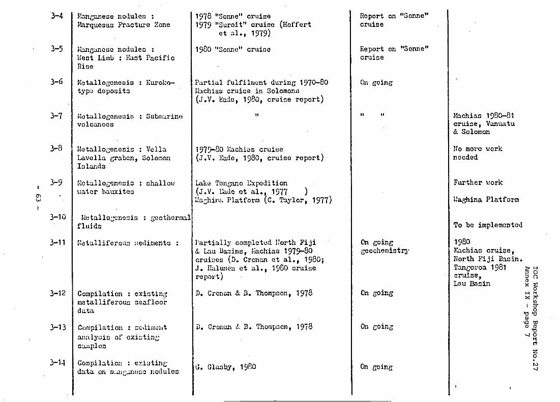
No.27
cc1 0
Y.
G
c)
E
Q) l-4 a
E
er(
c
0
kd
00
00
=E
0
P 0
I3 ...
E: .r( 0
til
Q C 0
n
t- CI
cn c
.- n
+r k 0 a
al &
k e
o
mfi
z cn F ri a
. n
'3
.. c'1 al
N
.. .a
P ,q
cn
-
I rn
0
I rn P
P
Fl
I rn c
cf I r-3 c
Q
I I
Fl
rn P
I rrl
- 63 -