CCM-T4 (Amended 17-0824) · GENERAL CHARACTERISTICS OF T4 URBAN* ... and Corridors—are the diff...
50
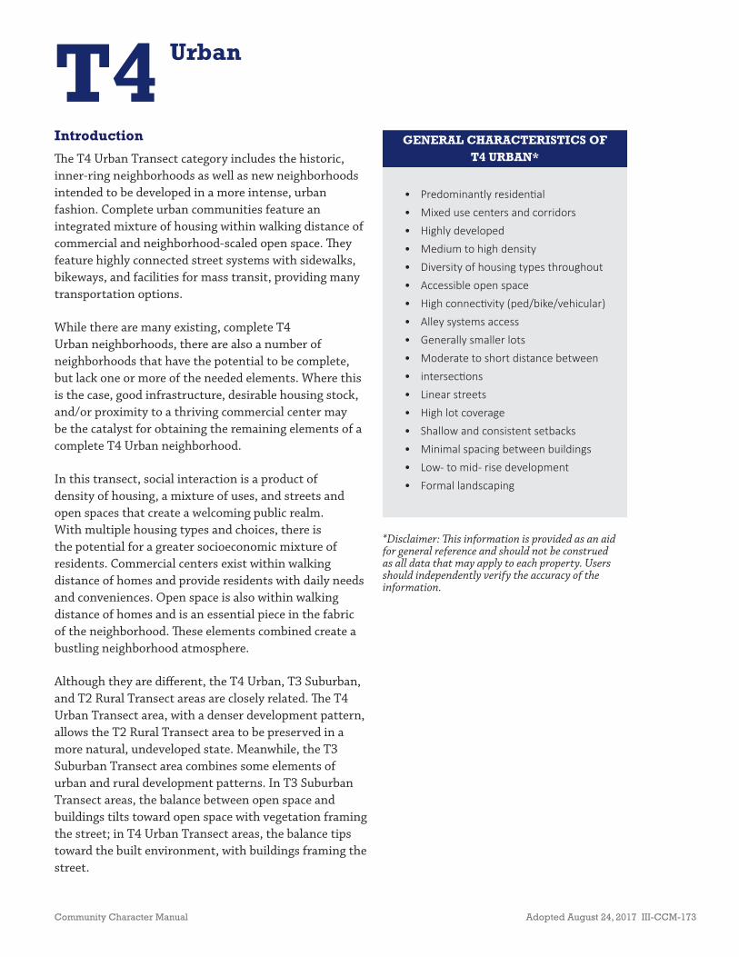
Community Character Manual Adopted August 24, 2017 III-CCM-173 T4 Urban Introduction e T4 Urban Transect category includes the historic, inner-ring neighborhoods as well as new neighborhoods intended to be developed in a more intense, urban fashion. Complete urban communities feature an integrated mixture of housing within walking distance of commercial and neighborhood-scaled open space. ey feature highly connected street systems with sidewalks, bikeways, and facilities for mass transit, providing many transportation options. While there are many existing, complete T4 Urban neighborhoods, there are also a number of neighborhoods that have the potential to be complete, but lack one or more of the needed elements. Where this is the case, good infrastructure, desirable housing stock, and/or proximity to a thriving commercial center may be the catalyst for obtaining the remaining elements of a complete T4 Urban neighborhood. In this transect, social interaction is a product of density of housing, a mixture of uses, and streets and open spaces that create a welcoming public realm. With multiple housing types and choices, there is the potential for a greater socioeconomic mixture of residents. Commercial centers exist within walking distance of homes and provide residents with daily needs and conveniences. Open space is also within walking distance of homes and is an essential piece in the fabric of the neighborhood. ese elements combined create a bustling neighborhood atmosphere. Although they are different, the T4 Urban, T3 Suburban, and T2 Rural Transect areas are closely related. e T4 Urban Transect area, with a denser development pattern, allows the T2 Rural Transect area to be preserved in a more natural, undeveloped state. Meanwhile, the T3 Suburban Transect area combines some elements of urban and rural development patterns. In T3 Suburban Transect areas, the balance between open space and buildings tilts toward open space with vegetation framing the street; in T4 Urban Transect areas, the balance tips toward the built environment, with buildings framing the street. • Predominantly residenƟal • Mixed use centers and corridors • Highly developed • Medium to high density • Diversity of housing types throughout • Accessible open space • High connecƟvity (ped/bike/vehicular) • Alley systems access • Generally smaller lots • Moderate to short distance between • intersecƟons • Linear streets • High lot coverage • Shallow and consistent setbacks • Minimal spacing between buildings • Low- to mid- rise development • Formal landscaping GENERAL CHARACTERISTICS OF T4 URBAN* *Disclaimer: is information is provided as an aid for general reference and should not be construed as all data that may apply to each property. Users should independently verify the accuracy of the information.
Transcript of CCM-T4 (Amended 17-0824) · GENERAL CHARACTERISTICS OF T4 URBAN* ... and Corridors—are the diff...
Community Character Manual Adopted August 24, 2017 III-CCM-173
T4 Urban
Introduction
Th e T4 Urban Transect category includes the historic, inner-ring neighborhoods as well as new neighborhoods intended to be developed in a more intense, urban fashion. Complete urban communities feature an integrated mixture of housing within walking distance of commercial and neighborhood-scaled open space. Th ey feature highly connected street systems with sidewalks, bikeways, and facilities for mass transit, providing many transportation options.
While there are many existing, complete T4 Urban neighborhoods, there are also a number of neighborhoods that have the potential to be complete, but lack one or more of the needed elements. Where this is the case, good infrastructure, desirable housing stock, and/or proximity to a thriving commercial center may be the catalyst for obtaining the remaining elements of a complete T4 Urban neighborhood.
In this transect, social interaction is a product of density of housing, a mixture of uses, and streets and open spaces that create a welcoming public realm. With multiple housing types and choices, there is the potential for a greater socioeconomic mixture of residents. Commercial centers exist within walking distance of homes and provide residents with daily needs and conveniences. Open space is also within walking distance of homes and is an essential piece in the fabric of the neighborhood. Th ese elements combined create a bustling neighborhood atmosphere.
Although they are diff erent, the T4 Urban, T3 Suburban, and T2 Rural Transect areas are closely related. Th e T4 Urban Transect area, with a denser development pattern, allows the T2 Rural Transect area to be preserved in a more natural, undeveloped state. Meanwhile, the T3 Suburban Transect area combines some elements of urban and rural development patterns. In T3 Suburban Transect areas, the balance between open space and buildings tilts toward open space with vegetation framing the street; in T4 Urban Transect areas, the balance tips toward the built environment, with buildings framing the street.
• Predominantly residen al• Mixed use centers and corridors• Highly developed• Medium to high density• Diversity of housing types throughout• Accessible open space• High connec vity (ped/bike/vehicular)• Alley systems access• Generally smaller lots• Moderate to short distance between • intersec ons• Linear streets• High lot coverage• Shallow and consistent setbacks• Minimal spacing between buildings• Low- to mid- rise development• Formal landscaping
GENERAL CHARACTERISTICS OF T4 URBAN*
*Disclaimer: Th is information is provided as an aid for general reference and should not be construed as all data that may apply to each property. Users should independently verify the accuracy of the information.
III-CCM-174 Adopted August 24, 2017 Community Character Manual
T4 Urban
Community Elements
Four Community Elements—Open Space, Neighborhoods, Centers, and Corridors—are the diff erent kinds of places found within each of the developed Transect Categories. Th e scale, character, and intensity of the Community Element varies depending on the Transect Category in which it is located. Not all community elements are found in each Transect Category.
Open Space
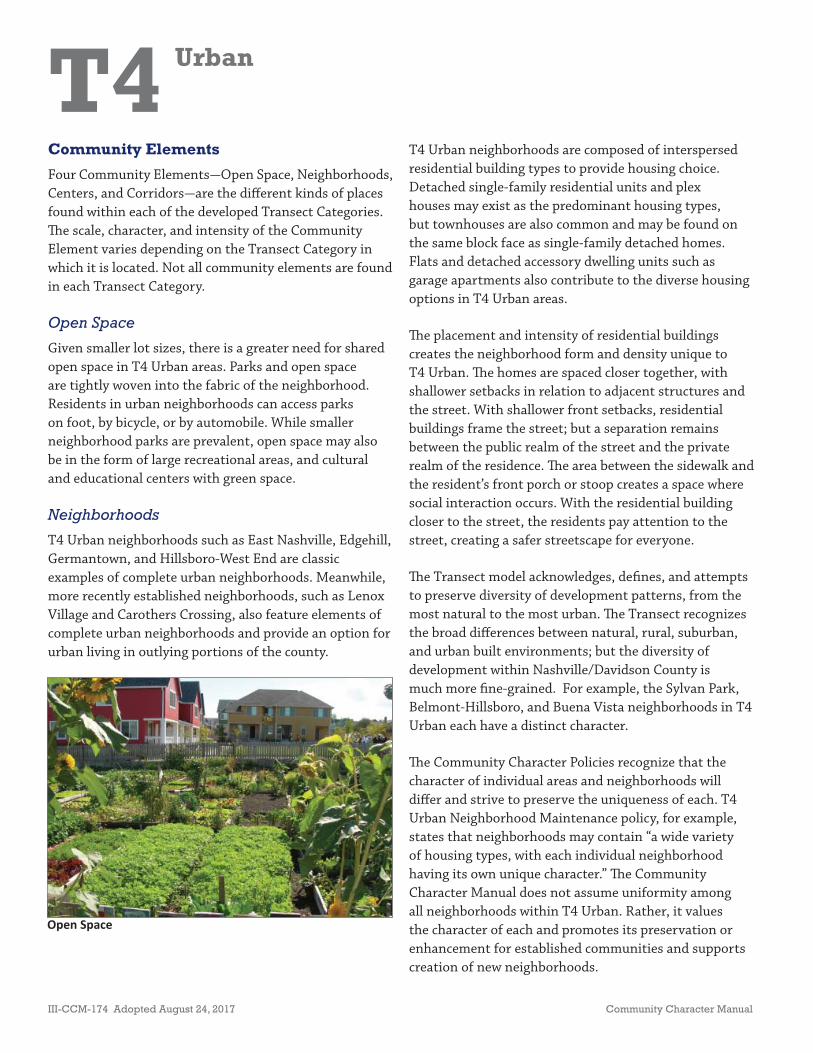
Given smaller lot sizes, there is a greater need for shared open space in T4 Urban areas. Parks and open space are tightly woven into the fabric of the neighborhood. Residents in urban neighborhoods can access parks on foot, by bicycle, or by automobile. While smaller neighborhood parks are prevalent, open space may also be in the form of large recreational areas, and cultural and educational centers with green space.
Neighborhoods
T4 Urban neighborhoods such as East Nashville, Edgehill, Germantown, and Hillsboro-West End are classic examples of complete urban neighborhoods. Meanwhile, more recently established neighborhoods, such as Lenox Village and Carothers Crossing, also feature elements of complete urban neighborhoods and provide an option for urban living in outlying portions of the county.
T4 Urban neighborhoods are composed of interspersed residential building types to provide housing choice. Detached single-family residential units and plex houses may exist as the predominant housing types, but townhouses are also common and may be found on the same block face as single-family detached homes. Flats and detached accessory dwelling units such as garage apartments also contribute to the diverse housing options in T4 Urban areas.
Th e placement and intensity of residential buildings creates the neighborhood form and density unique to T4 Urban. Th e homes are spaced closer together, with shallower setbacks in relation to adjacent structures and the street. With shallower front setbacks, residential buildings frame the street; but a separation remains between the public realm of the street and the private realm of the residence. Th e area between the sidewalk and the resident’s front porch or stoop creates a space where social interaction occurs. With the residential building closer to the street, the residents pay attention to the street, creating a safer streetscape for everyone.
Th e Transect model acknowledges, defi nes, and attempts to preserve diversity of development patterns, from the most natural to the most urban. Th e Transect recognizes the broad diff erences between natural, rural, suburban, and urban built environments; but the diversity of development within Nashville/Davidson County is much more fi ne-grained. For example, the Sylvan Park, Belmont-Hillsboro, and Buena Vista neighborhoods in T4 Urban each have a distinct character.
Th e Community Character Policies recognize that the character of individual areas and neighborhoods will diff er and strive to preserve the uniqueness of each. T4 Urban Neighborhood Maintenance policy, for example, states that neighborhoods may contain “a wide variety of housing types, with each individual neighborhood having its own unique character.” Th e Community Character Manual does not assume uniformity among all neighborhoods within T4 Urban. Rather, it values the character of each and promotes its preservation or enhancement for established communities and supports creation of new neighborhoods.
Open Space
Community Character Manual Adopted August 24, 2017 III-CCM-175
T4 Urban
Centers
Residents in urban neighborhoods are generally within a fi ve- to ten-minute walk of neighborhood-scaled commercial and mixed use centers. Urban centers are often mixed use, accommodating commercial and residential land uses. Mixed use buildings with residential or offi ce on upper fl oors and commercial uses on the ground fl oor promote active uses at the pedestrian level, adding to the bustling atmosphere of the neighborhood.
Th e scale of commercial and mixed use buildings in T4 Urban Neighborhood Centers and Community Centers complement the density and housing mix that surrounds them. Commercial and mixed use buildings have shallow setbacks or are built to the sidewalk, framing the street with buildings and creating an active sidewalk with fi rst-fl oor retail, offi ces, or restaurants. Because residents are within walking distance, parking in urban Centers is typically provided on the street or tucked away from view behind or beside the building.
Corridors
T4 Urban’s compact block structure and highly connected street grid make it comfortable to walk, with multiple route and travel options, to a mixed use Center or open space. Shorter block lengths make it easy for residents, employees, and visitors to move about the neighborhood.
Wide-reaching sidewalks and bikeways give T4 Urban residents options, in addition to the automobile, to reach their destinations. Th is infrastructure also provides the last mile link for many residents to reach bus routes or other modes of mass transit that more commonly serve densely populated neighborhoods.
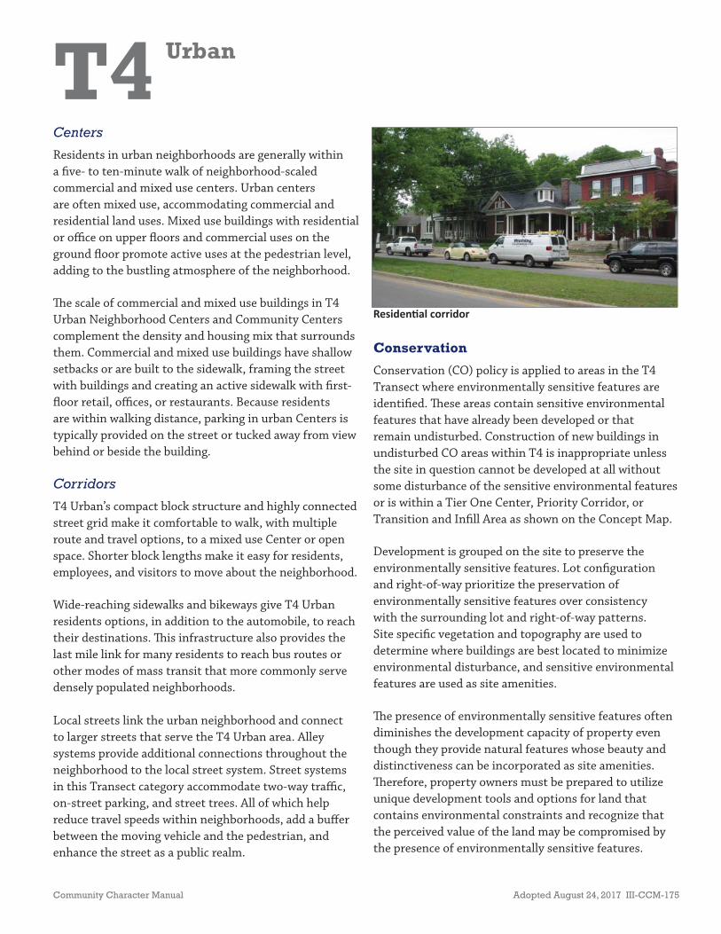
Local streets link the urban neighborhood and connect to larger streets that serve the T4 Urban area. Alley systems provide additional connections throughout the neighborhood to the local street system. Street systems in this Transect category accommodate two-way traffi c, on-street parking, and street trees. All of which help reduce travel speeds within neighborhoods, add a buff er between the moving vehicle and the pedestrian, and enhance the street as a public realm.
Residen al corridor
Conservation
Conservation (CO) policy is applied to areas in the T4 Transect where environmentally sensitive features are identifi ed. Th ese areas contain sensitive environmental features that have already been developed or that remain undisturbed. Construction of new buildings in undisturbed CO areas within T4 is inappropriate unless the site in question cannot be developed at all without some disturbance of the sensitive environmental features or is within a Tier One Center, Priority Corridor, or Transition and Infi ll Area as shown on the Concept Map.
Development is grouped on the site to preserve the environmentally sensitive features. Lot confi guration and right-of-way prioritize the preservation of environmentally sensitive features over consistency with the surrounding lot and right-of-way patterns. Site specifi c vegetation and topography are used to determine where buildings are best located to minimize environmental disturbance, and sensitive environmental features are used as site amenities.
Th e presence of environmentally sensitive features often diminishes the development capacity of property even though they provide natural features whose beauty and distinctiveness can be incorporated as site amenities. Th erefore, property owners must be prepared to utilize unique development tools and options for land that contains environmental constraints and recognize that the perceived value of the land may be compromised by the presence of environmentally sensitive features.
III-CCM-176 Adopted August 24, 2017 Community Character Manual
T4 Urban
Additional Guidance for Development of Sites that Contain Historically Significant Features
Many areas contain buildings or settings that are historically signifi cant to Nashvillians and visitors alike. Th ese sites serve not only as reminders of the history of the community, but also as expressions of Nashville’s social and cultural identity. Structures and sites that are determined to meet one of the following criteria are strongly recommended to be preserved and enhanced as part of any new development:
• Th e subject structure and/or site have been designated one of the following by the Metropolitan Historical Commission (MHC) and/or Metropolitan Historic Zoning Commission (MHZC):
- Worthy of Conservation
- Eligible for Listing in the National Register of Historic Places
- Listed in the National Register of Historic Places
- National Historic Landmark
Owners of property that contains historic or archaeological features or historic structures are encouraged to work with the MHC to protect and preserve the historic features in conjunction with any proposed development of the site. Th e potential impacts of proposed developments on historic sites or areas with archaeological features should be carefully considered, and appropriate measures should be applied that mitigate any adverse impacts. Development near structures or in areas of local, state, or national historical signifi cance should make eff orts to balance new development with the existing character, scale, massing and orientation of those historical features. Changes to properties located within a Neighborhood Conservation, Historic Preservation, or Historic Landmark zoning overlay must comply with the applicable design guidelines.
Zoning
Many properties contain land uses and/or are zoned with districts that are not consistent with the policy, including older development plans that were approved, but that are not built. Th ese development plans have existing development rights that allow development within an approved density and/or intensity. If no changes to the approved plans are sought, what was previously approved can be built without guidance from the Community Character Manual (CCM) or the applicable Community Plan. In some cases, however, development plans may require additional review if signifi cant changes to the approved plans are sought. In those cases, the policies of the CCM or applicable Community Plan provide guidance. Additional tools are also available, such as amendments, rezoning, subdivisions, and public investments, to ensure that future development incorporates as many of the designated community character objectives as possible.
Th e following policies are used to guide the rezoning of properties that contain land uses and/or are zoned with districts that are not consistent with the policy.
Sites with uses and/or zoning that are not consistent with the policy are generally encouraged to redevelop in accordance with the policy whenever such uses cease or when the areas are rezoned. Communities are sometimes confronted with proposals for adaptive reuse of sites or buildings where such existing activities are no longer viable. Proposals for adaptive reuse of such sites may be accompanied by rezoning requests, which would be reviewed for consistency with policy. Zone change applications for such sites may be considered on their merits provided that:
• Th ere is no territorial expansion of the inconsistent use and/or zoning;
• Proposed development would generate minimal non-local traffi c and the traffi c can be adequately served by the existing transportation network;
• Proposed development can be adequately served by existing infrastructure;

Community Character Manual Adopted August 24, 2017 III-CCM-177
T4 Urban
• Proposed development is consistent with the character of the Transect area in which the site is located;
• Proposed development is consistent with the Design Principles of the policy;
• Appropriate zoning can be applied, which, in the course of accommodating an acceptable proposed development, does not expose the adjoining area to the potential for incompatible land uses.
In the absence of acceptable development proposals, sites that contain existing uses and/or zoning that are inconsistent with the policy and are no longer viable should be rezoned to be more compatible with the applicable policy. Proposed zone changes to allow changes in uses and/or zoning districts that are inconsistent with policy to move further away from conforming to the policy need to be accompanied by a Community Plan Amendment Application for a policy that would support them.
Th ere may be certain kinds of institutional uses supported by the policy that may be proposed for some type of adaptive reuse (e.g. a religious or educational institution). Adaptive reuse proposals may include activities that the policy would not normally support. Rezoning requests may accompany proposals for adaptive reuse of these sites, which would be reviewed for consistency with the policy. In order to encourage preservation of institutional structures that are important to the community’s history, fabric, and character, zone change applications that would grant fl exibility for adaptive reuse may be considered on their merits provided that:
• Th e subject structure and/or site have been designated one of the following by the MHC and/or MHZC:
- Worthy of Conservation
- Eligible for Listing in the National Register of Historic Places
- Listed in the National Register of Historic Places
- National Historic Landmark
- A contributing structure in a Neighborhood Conservation, Historic Preservation, or Historic Landmark zoning overlay district
• Any alterations to the subject structure and/or site will follow the Secretary of Interior’s Standards;
• Th ere is no territorial expansion of the proposed use and/or zoning beyond the current historically signifi cant structure and/or site;
• Proposed development would generate minimal non-local traffi c and the traffi c can be adequately served by the existing transportation network;
• Proposed development can be adequately served by existing infrastructure;
• Proposed development is consistent with the character of the Transect Area in which the site is located;
• Proposed development is consistent with the Design Principles of the policy;
• Appropriate zoning can be applied which, in the course of accommodating an acceptable proposed development, prohibits the demolition of and inappropriate renovations to the structure and does not expose the adjoining area to the potential for incompatible land uses.
Additional Guidance in Community Plans and Detailed Plans
Additional policy guidance for any of the sections below may be established in a Community Plan or Detailed Plan. Refer to the applicable plan for the site in question to determine if additional policy guidance exists.
III-CCM-178 Adopted August 24, 2017 Community Character Manual
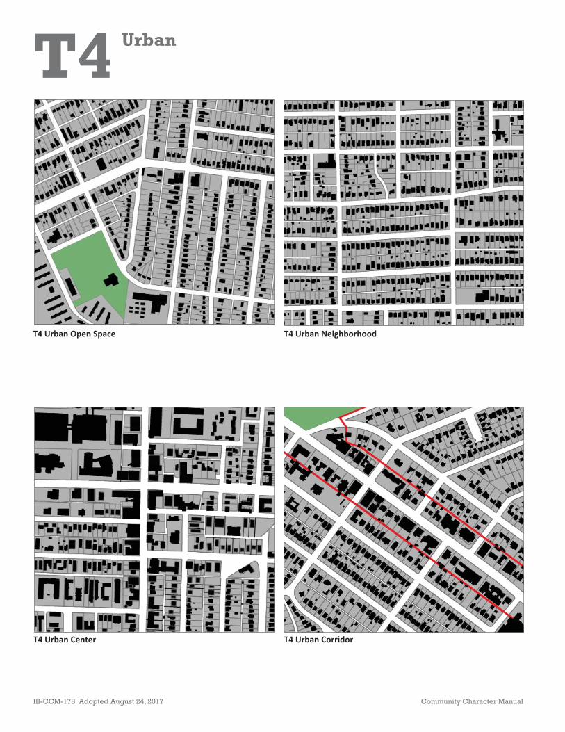
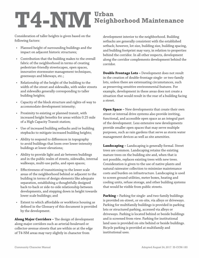
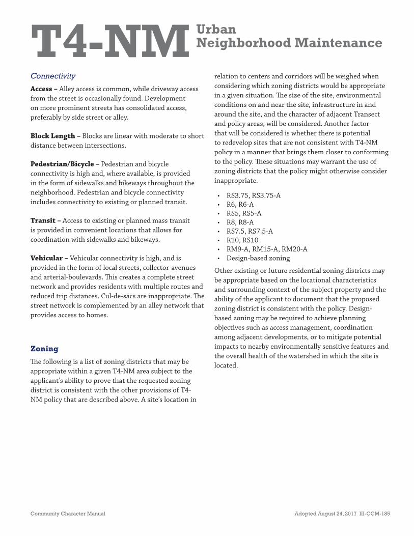
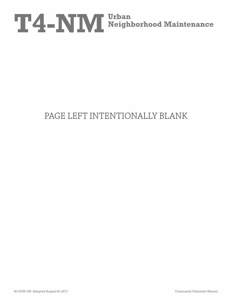
T4 Urban Open Space
T4 Urban CorridorT4 Urban Center
T4 Urban Neighborhood
T4 Urban

Community Character Manual Adopted August 24, 2017 III-CCM-179
T4 Urban
PAGE LEFT INTENTIONALLY BLANK

III-CCM-180 Adopted August 24, 2017 Community Character Manual
Transect Elements Policy
T4
Intent
Neighborhoods
Centers
Corridors
T4 Urban Neighborhood Maintenance
T4 Urban Neighborhood Evolving
T4 Urban Mixed-Use Neighborhood
Create & ,
T4 Urban Neighborhood Center
T4 Urban Community Center
Enhance
T4 Urban Residential Corridor
T4 Urban Mixed-Use Corridor
,
Create &
,
T4 Urban

T4-NM UrbanNeighborhood Maintenance
Community Character Manual Adopted August 24, 2017 III-CCM-181
Policy Intent
Maintain urban neighborhoods as characterized by their moderate- to high-density residential development pattern, building form/types, setbacks, and building rhythm along the street.
General Characteristics
T4 Urban Neighborhood Maintenance (T4-NM) areas will experience some changes over time, primarily when buildings are expanded or replaced. When this occurs, eff orts should be made to retain the existing character of the neighborhood. Where transportation infrastructure is insuffi cient or not present, enhancements are necessary to improve pedestrian, bicycle, and vehicular connectivity.
T4-NM areas have an established development pattern consisting of the following:
• Moderate- to high-density residential development and institutional land uses;
• Regularly spaced buildings with shallow setbacks and minimal spacing between;
• Lots generally accessed from alleys;
• Consistent use of lighting and generally more formal landscaping;
• High levels of connectivity with complete street networks, sidewalks, bikeways, and existing or planned mass transit;
• Clearly distinguishable boundaries identifi ed by block structure, consistent lot size, and building placement; and
• “Infi ll Areas” in T4-NM diff er from T4 Urban Neighborhood Evolving areas, which are generally larger and have a diff erent policy intent–one that places a greater emphasis on establishing a more diverse mix of housing.
• RS3.75, RS3.75-A • R6, R6-A• RS5, RS5-A• RS7.5, RS7.5-A• R8, R8-A• R10, RS10
• RM9-A• RM15-A• RM20-A• Design-based
zoning
ZONING*
• Residen al• Community Gardens & Other Open
Spaces• Ins tu onal
EXAMPLES OF APPROPRIATE LAND USES*
*Disclaimer: Th is information is provided as an aid for general reference and should not be construed as all data that may apply to each property. Users should independently verify the accuracy of the information.
• House• Detached Accessory Dwelling Unit• Plex House• House Court• Low-rise Townhouse• Mid-rise Townhouse• Manor House• Low-Rise Flat• Mid-Rise Flat• Ins tu onal
BUILDING TYPES

T4-NM UrbanNeighborhood Maintenance
III-CCM-182 Adopted August 24, 2017 Community Character Manual
Application
T4-NM policy is applicable to areas that are zoned residential, where the primary land use is residential, or that are envisioned to remain primarily residential. T4-NM policy is applied in situations where there is an expressed interest in maintaining the predominant, existing developed condition and that condition is believed to be stable and sustainable over time.
Commonly used boundaries to defi ne T4-NM areas include, but are not limited to: boundaries defi ned by established development patterns to be maintained (considering lot size, spacing of buildings), environmental features, human-made features (rail lines, major utility easements, prominent streets), and transitional uses (open space, institutional). Th e application and boundary delineation of this policy are established during the Community Planning process.
Design Principles
Building Form and Site Design
Building height, form, and orientation fi t in with the urban character and development pattern of the specifi c area to which the T4-NM policy has been applied. T4-NM areas may contain a wide variety of housing types, with each individual neighborhood having its own unique character.
Th e mixture and placement of building types consider the street type and eff ects on nearby sensitive environmental features guided by Conservation policy and the overall health of the watershed. While protection of an individual environmentally sensitive feature—a sink hole, a steep slope, etc.—may lead to a site plan that avoids this feature, the protection of the overall health of the watershed, may lead to building and site design that reduce stormwater runoff through compact site design and other innovative building and site design features.
Massing – Building massing results in building footprints with moderate to high lot coverage.
Orientation – Buildings are oriented to the street or to an open space where a street does not exist. Types of open spaces may vary and could include courtyards or other types of functional and accessible open spaces.
Setbacks – Buildings have shallow and regular setbacks, providing some distinction between the public realm of the sidewalk and the private realm of the residence. Within this setback, stoops and porches are common to provide for some interaction between the public and private realm and to create a pedestrian-friendly environment. Th ere is minimal spacing between buildings.
Density – Density is secondary to the form of development; however, these areas are intended to be moderate- to high-density. Since T4-NM policy is applied to predominantly developed neighborhoods whose character is intended to be maintained, the appropriate density is determined by the existing character of each individual neighborhood in terms of characteristics such as the mix of housing types, building setbacks and spacing, and block structure.
Building Height – Buildings in this area are generally one to three stories tall within the interior of the neighborhood. Taller buildings of up to four stories may be found abutting or adjacent to Centers and Corridors, depending on their surrounding context.
Homes with shallow setbacks, porches and street orienta on
T4-NM UrbanNeighborhood Maintenance
Community Character Manual Adopted August 24, 2017 III-CCM-183
Consideration of taller heights is given based on the following factors:
• Planned height of surrounding buildings and the impact on adjacent historic structures;
• Contribution that the building makes to the overall fabric of the neighborhood in terms of creating pedestrian-friendly streetscapes, open spaces, innovative stormwater management techniques, greenways and bikeways, etc.;
• Relationship of the height of the building to the width of the street and sidewalks, with wider streets and sidewalks generally corresponding to taller building heights;
• Capacity of the block structure and rights-of-way to accommodate development intensity;
• Proximity to existing or planned transit, with increased height benefi ts for areas within 0.25 mile of a High Capacity Transit station;
• Use of increased building setbacks and/or building stepbacks to mitigate increased building heights;
• Ability to respond to diff erences in topography to avoid buildings that loom over lower-intensity buildings at lower elevations;
• Ability to provide light and air between buildings and in the public realm of streets, sidewalks, internal walkways, multi-use paths, and open spaces;
• Eff ectiveness of transitioning to the lower scale areas of the neighborhood behind or adjacent to the building in terms of design elements like adequate separation, establishing a thoughtfully designed back-to-back or side-to-side relationship between developments, and stepping down in height towards lower scale buildings; and
• Extent to which aff ordable or workforce housing as defi ned in the Glossary of this document is provided by the development.
Along Major Corridors – Th e design of development along major corridors such as arterial-boulevard or collector-avenue streets that are within or at the edge of T4-NM areas may vary slightly in character from
development interior to the neighborhood. Building setbacks are generally consistent with the established setback; however, lot size, building size, building spacing, and building footprint may vary, in relation to properties behind the corridor. In all other respects, development along the corridor complements development behind the corridor.
Double Frontage Lots – Development does not result in the creation of double-frontage single- or two-family lots, unless there are extenuating circumstances, such as preserving sensitive environmental features. For example, development in these areas does not create a situation that would result in the rear of a building facing a street.
Open Space – New developments that create their own street or internal drive systems also provide inviting, functional, and accessible open space as an integral part of the development. Less extensive new developments provide smaller open spaces that may serve multiple purposes, such as rain gardens that serve as storm water management devices as well as site amenities.
Landscaping – Landscaping is generally formal. Street trees are common. Landscaping retains the existing mature trees on the building site and, when that is not possible, replaces existing trees with new trees. Consideration is given to the use of native plants and natural rainwater collection to minimize maintenance costs and burden on infrastructure. Landscaping is used to screen ground utilities, meter boxes, heating and cooling units, refuse storage, and other building systems that would be visible from public streets.
Parking – Parking for single- and two-family buildings is provided on-street, or on-site, via alleys or driveways. Parking for multifamily buildings is provided in parking lots or structured parking, accessed via alleys or driveways. Parking is located behind or beside buildings and is screened from view. Parking for institutional land uses is provided on-site behind or beside buildings. Bicycle parking is provided at multifamily and institutional uses.

T4-NM UrbanNeighborhood Maintenance
III-CCM-184 Adopted August 24, 2017 Community Character Manual
Higher intensity housing placed nearer to centers and corridors
Signage – Signage is rarely used at individual residences. Signage for institutional land uses alerts motorists, pedestrians, and cyclists to their location and assists them in fi nding their destination in a manner that is not distracting or overwhelming to the institutional use or the overall streetscape. Th e design and location of signage complement and contribute to the envisioned character of the neighborhood. Signage is generally scaled for vehicles, and monument signs are appropriate. Appropriate signage scaled for pedestrians includes building-mounted signs, projecting signs, or awning signs.
Transitioning
Infi ll – Established T4-NM areas may include areas of land that is vacant, underutilized, or in a nonresidential use that could redevelop. Examples could include large tracts of undeveloped land, an undeveloped farm, a former country club or church, etc. Th ese areas diff er from T4 Neighborhood Evolving areas because they are generally smaller and interior to the neighborhood. Such areas may be developed or redeveloped with a broader mix of housing types than the rest of the T4-NM area subject to appropriate design that transitions in building type, massing, and orientation in order to blend new development into the surrounding neighborhood. Further guidance for redeveloping
certain historically signifi cant institutional uses, such as religious institutions, is provided in the Zoning section of this Transect. In some cases, additional guidance for development or redevelopment of these infi ll areas may be outlined in a Community Plan.
Adjacent Historic Structures – New structures are designed to provide a transition in scale and massing to adjacent historic structures. A successful transition may be provided by reducing the height and massing of the new structure when approaching a smaller historic structure, and using a building type such as articulated townhouses near historic structures, to complement the historic structure’s form. Applicants are also encouraged to off er additional or alternative innovative ways to provide transition in scale, massing, and building type. In all cases, new structures adjacent to historic structures complement, in height and massing, historic structures and do not threaten the integrity of the historic property and its environment.
Higher Intensity – While T4-NM areas usually contain a mixture of residential building types, these are sometimes randomly located rather than thoughtfully placed in relation to the major street system or Corridor and Neighborhood and Community Center policy areas. Any future mix arranges building types in strategic locations through zoning decisions that place higher-intensity buildings nearer to Centers and Corridors and uses these more intense building types as land use transitions. Allowing for higher-intensity residential building types in such locations will add value to neighborhoods, growing the market and demand for consumer services and the demand for transit.
Areas with adequate infrastructure, access, and the ability to form transitions and support existing or planned mass transit and the viability of consumer businesses are most appropriate for higher density. Th ese are primarily areas along arterial-boulevard or collector-avenue street corridors internal to the neighborhood or abutting larger Centers and Corridors adjacent to the neighborhood.
T4-NM UrbanNeighborhood Maintenance
Community Character Manual Adopted August 24, 2017 III-CCM-185
Connectivity
Access – Alley access is common, while driveway access from the street is occasionally found. Development on more prominent streets has consolidated access, preferably by side street or alley.
Block Length – Blocks are linear with moderate to short distance between intersections.
Pedestrian/Bicycle – Pedestrian and bicycle connectivity is high and, where available, is provided in the form of sidewalks and bikeways throughout the neighborhood. Pedestrian and bicycle connectivity includes connectivity to existing or planned transit.
Transit – Access to existing or planned mass transit is provided in convenient locations that allows for coordination with sidewalks and bikeways.
Vehicular – Vehicular connectivity is high, and is provided in the form of local streets, collector-avenues and arterial-boulevards. Th is creates a complete street network and provides residents with multiple routes and reduced trip distances. Cul-de-sacs are inappropriate. Th e street network is complemented by an alley network that provides access to homes.
Zoning
Th e following is a list of zoning districts that may be appropriate within a given T4-NM area subject to the applicant’s ability to prove that the requested zoning district is consistent with the other provisions of T4-NM policy that are described above. A site’s location in
relation to centers and corridors will be weighed when considering which zoning districts would be appropriate in a given situation. Th e size of the site, environmental conditions on and near the site, infrastructure in and around the site, and the character of adjacent Transect and policy areas, will be considered. Another factor that will be considered is whether there is potential to redevelop sites that are not consistent with T4-NM policy in a manner that brings them closer to conforming to the policy. Th ese situations may warrant the use of zoning districts that the policy might otherwise consider inappropriate.
• RS3.75, RS3.75-A• R6, R6-A• RS5, RS5-A• R8, R8-A• RS7.5, RS7.5-A• R10, RS10• RM9-A, RM15-A, RM20-A• Design-based zoning
Other existing or future residential zoning districts may be appropriate based on the locational characteristics and surrounding context of the subject property and the ability of the applicant to document that the proposed zoning district is consistent with the policy. Design-based zoning may be required to achieve planning objectives such as access management, coordination among adjacent developments, or to mitigate potential impacts to nearby environmentally sensitive features and the overall health of the watershed in which the site is located.
T4-NM UrbanNeighborhood Maintenance
III-CCM-186 Adopted August 24, 2017 Community Character Manual
PAGE LEFT INTENTIONALLY BLANK
T4-NE UrbanNeighborhood Evolving
Community Character Manual Adopted August 24, 2017 III-CCM-187
Policy Intent
Create and enhance neighborhoods—to include greater housing choice, improved connectivity, and more creative, innovative, and environmentally sensitive development techniques.
General Characteristics
T4 Urban Neighborhood Evolving (T4-NE) areas will have higher densities and/or smaller lot sizes, with a broader range and integrated mixture of housing types, providing housing choice, than some surrounding urban neighborhoods. Where transportation infrastructure is insuffi cient or not present, enhancements may be necessary to improve pedestrian, bicycle, and vehicular connectivity. T4-NE areas have the characteristics of the following:
• Moderate- to high-density residential development and institutional land uses;
• Regularly spaced buildings with shallow setbacks and minimal spacing between buildings;
• Lots generally accessed from alleys;
• Consistent use of lighting and more formal landscaping;
• High levels of connectivity with complete street networks, sidewalks, bikeways, and existing or planned mass transit;
• Clearly distinguishable boundaries identifi ed by block structure, consistent lot size, and building placement; and
• “Infi ll Areas” in T4-NE diff er from T4 Urban Neighborhood Maintenance areas. T4-NE areas are generally larger and have a diff erent policy intent–one that places a greater emphasis on establishing a more diverse mix of housing and a higher level of connectivity.
• RS3.75, RS3.75-A • R6, R6-A• RS5, RS5-A• R8, R8-A• RS7.5, RS7.5-A
• RM9-A to RM40-A
• Design-based zoning
ZONING*
• Residen al• Community Gardens & Other Open
Spaces• Ins tu onal
EXAMPLES OF APPROPRIATE LAND USES*
*Disclaimer: Th is information is provided as an aid for general reference and should not be construed as all data that may apply to each property. Users should independently verify the accuracy of the information.
• House• Detached Accessory Dwelling Unit• Plex House• House Court• Low-rise Townhouse• Mid-rise townhouse• Manor House• Courtyard Flat• Low-Rise Flat• Mid-Rise Flat• Ins tu onal
BUILDING TYPES
T4-NE UrbanNeighborhood Evolving
III-CCM-188 Adopted August 24, 2017 Community Character Manual
Application
T4-NE policy is applicable to areas that are zoned residential, where the primary land use is residential, or that are envisioned to become primarily residential. T4-NE policy is typically applied in the following situations where there is:
• An expressed interest in the area’s development pattern progressing to promote a mixture of housing types and greater connectivity; or
• Existence of the following characteristics:
- High vacancy rates;
- High proportion of vacant land;
- High potential for consolidation or subdivision of incongruous lots (not an established lot pattern);
- Incongruity between the existing land use and the zoning;
- Proximity to evolving centers or corridors; and/or
- Age and condition of the existing development.
Commonly used boundaries to defi ne T4-NE areas include, but are not limited to: boundaries defi ned by evolving or intended development patterns (considering lot size, spacing of homes), environmental features, human-made features (rail lines, major utility easements, prominent roads and streets), and transitional uses (open space, institutional). Th e application and boundary delineation of this policy are established during the Community Planning process.
Design Principles
Building Form and Site Design
Building height, form, and orientation fi t in with the urban character and development pattern described in the Introduction to this section and the Policy Intent and General Characteristics of T4-NE policy. An integrated mixture of building types, including
single-family, detached accessory dwelling units, plex houses, townhouses, and fl ats, to create housing choice are found in T4-NE areas. Th e mixture and placement of building types considers the street type and is designed to be cohesive throughout the development—providing a thorough mix of housing types versus groupings of single types of housing.
Th e mixture and placement of building types consider the street type and eff ects on nearby sensitive environmental features guided by Conservation (CO) policy and the overall health of the watershed. While protection of an individual environmentally sensitive feature—a sink hole, a steep slope, etc.—may lead to a site plan that avoids this feature, the protection of the overall health of the watershed, may lead to building and site design that reduces stormwater runoff through compact site design and other innovative building and site design features.
Because many of these areas are currently undeveloped or underdeveloped, the development that occurs can have a disproportionate impact on the natural features in these areas, especially on streams and rivers. While CO policy is applied to environmentally sensitive features, including fl oodplains and steep slopes, areas outside of the fl oodplain still drain to streams, creeks, and rivers within the watershed. Achieving and maintaining healthy watersheds requires that new development in T4-NE areas be sensitively designed to contribute to their continuing health.
Massing – Building massing results in a footprint with moderate to high lot coverage.
Orientation – Buildings are oriented to the street or an open space where a street does not exist. Types of open spaces may vary and could include courtyards or other types of functional and accessible open spaces.
Setbacks – Building setbacks are shallow and regular, providing some distinction between the public realm of the sidewalk and the private realm of the residence. Within this setback, stoops and porches are common to provide for some interaction between the public

T4-NE UrbanNeighborhood Evolving
Community Character Manual Adopted August 24, 2017 III-CCM-189
Courtyard fl ats providing housing choice
and private realm and to create a pedestrian-friendly environment. Th ere is minimal spacing between buildings.
Density – Density is secondary to the form of development; however, T4-NE areas are intended to be moderate- to high- density with smaller lots and a more diverse mix of housing types than are typically found in T4 Urban Neighborhood Maintenance areas. Certain areas that are abutting or adjacent to Centers and Corridors may be appropriate for higher density housing and buildings, depending on their surrounding context.
Building Height – Buildings are generally one to three stories in height. Buildings up to four, possibly fi ve, stories may be supported in appropriate locations, such as abutting or adjacent to major corridors as identifi ed on the NashvilleNext Growth & Preservation Concept Map, abutting or adjacent to centers, and to support aff ordable and workforce housing.
Consideration of taller heights is based on the following factors:
• Adequate infrastructure, such as appropriately sized water and sewer service, complete streets, and streets and sidewalks that are adequately wide to support the increased height without the building overshadowing the street or degrading the pedestrian environment;
• Access to major transportation networks;
• Opportunities for higher connectivity;
• Ability to form transitions from adjacent higher-intensity development to the lower-scale neighborhood interior;
• Proximity to existing or planned transit, with increased height benefi ts for areas within 0.25 mile of a High Capacity Transit station;
• Ability to support the viability of nearby consumer businesses; and
• Ability to provide aff ordable or workforce housing as defi ned in the Glossary of this document.
Along Major Corridors – Th e mix of building types should be thoughtfully placed in relation to Corridors and Centers. Place taller buildings that contain more units abutting or adjacent to Centers and Corridors, and use these more intense building types as land use transitions.
Double Frontage Lots – Development does not result in the creation of double-frontage single- or two-family lots, unless there are extenuating circumstances, such as the need to avoid disturbing sensitive environmental features. For example, development does not create a situation that would result in the rear of a building facing a street.
Open Space – New developments that create their own street or internal drive systems also provide inviting, functional, and accessible open space as an integral part of the development. Th is is particularly important in areas with a defi ciency of public open space or where there is a need to protect nearby sensitive environmental features or watersheds. Less extensive new developments provide smaller open spaces that may serve multiple purposes, such as rain gardens that serve as storm water management devices as well as site amenities. New developments near existing parks may have less shared open space within the development, but still should provide green space.
T4-NE UrbanNeighborhood Evolving
III-CCM-190 Adopted August 24, 2017 Community Character Manual
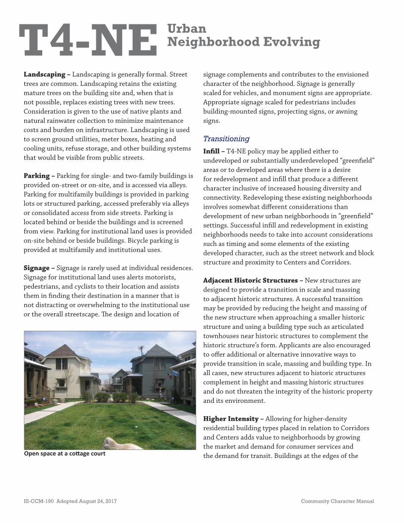
Open space at a co age court
Landscaping – Landscaping is generally formal. Street trees are common. Landscaping retains the existing mature trees on the building site and, when that is not possible, replaces existing trees with new trees. Consideration is given to the use of native plants and natural rainwater collection to minimize maintenance costs and burden on infrastructure. Landscaping is used to screen ground utilities, meter boxes, heating and cooling units, refuse storage, and other building systems that would be visible from public streets.
Parking – Parking for single- and two-family buildings is provided on-street or on-site, and is accessed via alleys. Parking for multifamily buildings is provided in parking lots or structured parking, accessed preferably via alleys or consolidated access from side streets. Parking is located behind or beside the buildings and is screened from view. Parking for institutional land uses is provided on-site behind or beside buildings. Bicycle parking is provided at multifamily and institutional uses.
Signage – Signage is rarely used at individual residences. Signage for institutional land uses alerts motorists, pedestrians, and cyclists to their location and assists them in fi nding their destination in a manner that is not distracting or overwhelming to the institutional use or the overall streetscape. Th e design and location of
signage complements and contributes to the envisioned character of the neighborhood. Signage is generally scaled for vehicles, and monument signs are appropriate. Appropriate signage scaled for pedestrians includes building-mounted signs, projecting signs, or awning signs.
Transitioning
Infi ll – T4-NE policy may be applied either to undeveloped or substantially underdeveloped “greenfi eld” areas or to developed areas where there is a desire for redevelopment and infi ll that produce a diff erent character inclusive of increased housing diversity and connectivity. Redeveloping these existing neighborhoods involves somewhat diff erent considerations than development of new urban neighborhoods in “greenfi eld” settings. Successful infi ll and redevelopment in existing neighborhoods needs to take into account considerations such as timing and some elements of the existing developed character, such as the street network and block structure and proximity to Centers and Corridors.
Adjacent Historic Structures – New structures are designed to provide a transition in scale and massing to adjacent historic structures. A successful transition may be provided by reducing the height and massing of the new structure when approaching a smaller historic structure and using a building type such as articulated townhouses near historic structures to complement the historic structure’s form. Applicants are also encouraged to off er additional or alternative innovative ways to provide transition in scale, massing and building type. In all cases, new structures adjacent to historic structures complement in height and massing historic structures and do not threaten the integrity of the historic property and its environment.
Higher Intensity – Allowing for higher-density residential building types placed in relation to Corridors and Centers adds value to neighborhoods by growing the market and demand for consumer services and the demand for transit. Buildings at the edges of the

T4-NE UrbanNeighborhood Evolving
Community Character Manual Adopted August 24, 2017 III-CCM-191
Higher density housing along corridor
T4-NE area form transitions in scale and massing where it adjoins lower-density policy areas, with thoughtful attention given to the placement and orientation of buildings within these edges as they relate to their surroundings. Higher density through rezoning occurs as proposals are judged on their merits and ability to meet the goals of the Community Plan. Buildings at these edges:
• Step down in height as they move closer to adjacent lower-density areas. Th is may require diff erent heights within an individual structure;
• Avoid placing parking lot entrances opposite lower-density areas;
• Respond to diff erences in topography to avoid buildings that loom over smaller buildings at lower elevations;
• Respond to the height of smaller adjacent historic buildings so that they do not loom over them;
• Are oriented so that there is a back-to-back relationship between the taller buildings and smaller buildings;
• Are separated from lower-density areas by rear alleys or service lanes; and
• Have articulated façades that face lower-intensity policy areas.
Connectivity
Access – Access by alleys is preferred. Development on larger streets has consolidated access, preferably by side street or alley.
Block Length – Blocks are linear with moderate to short distance between intersections.
Pedestrian/Bicycle – Pedestrian and bicycle connectivity is high and, where available, is provided in the form of sidewalks and bikeways throughout the neighborhood. Pedestrian and bicycle connectivity to existing or planned transit is included.
Transit – Access to mass transit is provided in convenient locations that allows for coordination with sidewalks and bikeways.
Vehicular – Vehicular connectivity is high, and is provided in the form of local streets, collector-avenues and arterial-boulevards that create a complete street network, and provide residents with multiple routes and reduced trip distances. Cul-de-sacs are highly discouraged. Th e street network is complemented with an alley network that provides access to residences. As new development occurs, special attention is paid to the existing collector-avenue and arterial-boulevard streets in the area to determine if these streets are able to support additional development. If existing streets cannot support the use generated by the evolving urban neighborhoods, improvements to these streets or reclassifi cation of these streets may be necessary. It may also be necessary for the new development to create higher-order collector-avenue or arterial-boulevard streets.
Balancing Conservation and Evolving Policies
Decisions for properties in T4-NE areas containing CO policy require fl exibility, because environmental constraints may make it diffi cult to construct certain building types without disturbing the sensitive features.

T4-NE UrbanNeighborhood Evolving
III-CCM-192 Adopted August 24, 2017 Community Character Manual
Development is grouped on the site to preserve the environmentally sensitive features. Lot confi guration and right-of-way prioritize the preservation of environmentally sensitive features over consistency with surrounding lot and right-of-way patterns. Site-specifi c vegetation and topography are used to determine where buildings are best located to minimize environmental disturbance. Sensitive environmental features are used as site amenities.
Building mass is generally small footprint in relation to the lot size to protect environmentally sensitive features.Building heights are generally consistent with the T4-NE policy. However, heights may be more limited than would otherwise be appropriate based on factors such as the need to alter sensitive environmental features for engineering purposes to achieve the desired height or to provide access and parking.
Building orientation and placement minimize disturbance of existing environmental features while striking a balance between the need to preserve or remediate environmentally sensitive features and the need to encourage urban infi ll development. Buildings are oriented to face public streets to the extent that protecting sensitive environmental features permits.
Th e adequacy of infrastructure (including, but not limited to, roads and sewers) and the feasibility of extending infrastructure is also considered with development of property with or adjacent to CO policy. For example, a property guided by CO and T4-NE policies may not be able to achieve increased intensity where surrounding sensitive environmental features limit provision of adequate infrastructive and connectivity improvements.
Zoning
Th e following is a list of zoning districts that may be appropriate within a given T4-NE area subject to the applicant’s ability to prove that the requested zoning district is consistent with the other provisions of T4-NE policy that are described above. A site’s location in relation to centers, corridors and multi-modal transportation options will be weighed when considering which zoning districts would be appropriate in a given situation. Th e size of the site, environmental conditions on and near the site, and the character of adjacent Transect and policy areas, will be considered. Another factor that will be considered is whether there is potential to redevelop sites that are not consistent with T4-NE
policy in a manner that brings them closer to conforming to the policy. Th ese situations may warrant the use of zoning districts that the policy might otherwise consider inappropriate.
• RS3.75, RS3.75-A• R6, R6-A• RS5, RS5-A• R8, R8-A• RS7.5, RS7.5-A• RM9-A to RM40-A• Design-based zoning
Other existing or future residential zoning districts may be appropriate based on the locational characteristics and surrounding context of the subject property and the ability of the applicant to document that the proposed zoning district is consistent with the policy. Design-based zoning may be required to achieve planning objectives such as access management, coordination among adjacent developments, or to mitgate potential impacts to nearby environmentally sensitive features.

T4-MU UrbanMixed Use Neighborhood
Community Character Manual Adopted August 24, 2017 III-CCM-193
Policy Intent
Maintain, enhance, and create urban, mixed use neighborhoods with a diverse mix of moderate- to high density residential, commercial, offi ce, and light industrial land uses.
General Characteristics
T4 Urban Mixed Use Neighborhood (T4-MU) areas will have high levels of connectivity and complete street networks with sidewalks, bikeways, and existing or planned transit. Where transportation infrastructure is insuffi cient or not present, enhancements may be necessary to improve pedestrian, bicycle, and vehicular connectivity. T4-MU areas have the characteristics of the following:
• Moderate- to high-density residential development, mixed use, commercial, light industrial, and institutional uses;
• Regularly spaced buildings built to the back edge of the sidewalk and minimal spacing between buildings;
• Parking behind or beside the buildings and generally accessed by side streets or alleys;
• Consistent use of lighting and formal landscaping;
• High levels of connectivity with complete street networks, sidewalks, bikeways, and existing or planned mass transit; and
• Clearly distinguishable boundaries identifi ed by block structure, street and alley networks, and building placement.
Application
T4-MU policy is applicable to areas that are zoned residential, commercial, and light industrial, where the primary land use is residential, commercial, and light industrial or that are envisioned to become primarily mixed use with residential and ancillary commercial and light industrial. T4-MU policy is typically applied in the following situations where there is:
• MUN-A• MUL-A• OR20-A, R40-A
• RM9-A to RM40-A
• Design-based zoning
ZONING*
• Residen al• Mixed Use• Community Gardens & Other Open
Spaces• Ins tu onal• Offi ce• Commercial• Light industrial including non-
nuisance type cra s and other “co age” industrial, light warehousing/distribu on.
EXAMPLES OF APPROPRIATE LAND USES*
*Disclaimer: Th is information is provided as an aid for general reference and should not be construed as all data that may apply to each property. Users should independently verify the accuracy of the information.
• House• Detached Accessory Dwelling Unit• Plex House• House Court• Low-rise Townhouse• Mid-rise Townhouse• Manor House• Courtyard Flat• Low-Rise Flat• Mid-Rise Flat• Low-Rise Mixed Use• Mid-Rise Mixed Use• Low-Rise Commercial• Ins tu onal
BUILDING TYPES

T4-MU UrbanMixed Use Neighborhood
III-CCM-194 Adopted August 24, 2017 Community Character Manual
• An expressed interest in the area’s development pattern progressing to promote a mixture of housing types, commercial, light industrial land uses, and greater connectivity; or
• Existence of the following characteristics:
- High vacancy rates;
- High potential for consolidation or subdivision of incongruous lots (not an established lot pattern);
- Incongruity between the existing land use and the zoning;
- Proximity to evolving centers or corridors; and
- Age and condition of the existing development
Commonly used boundaries to defi ne T4-MU areas include, but are not limited to: boundaries defi ned by evolving or intended development patterns (considering lot size, mass, spacing, orientation of buildings), environmental features, human-made features (rail lines, major utility easements, prominent roads and streets), and transitional uses (open space, institutional). Because of the potential to contain commercial and light industrial ancillary to residential, this policy does not intrude into the defi ned boundaries of non-urban mixed use neighborhood policies. Th e application and boundary delineation of this policy are established during the Community Planning process.
Design Principles
Building Form and Site Design
Th e building form is generally in character with the existing development pattern of the urban neighborhood in terms of its mass, orientation, and placement. Th e building form is also appropriate to the street type and is designed to be compatible, on the edges of the T4-MU policy, with adjacent policy areas.
Low-rise mixed use (live/work units)
Massing – Th e massing of residential buildings results in footprints with moderate to high lot coverage. Th e massing of mixed use and non-residential buildings results in a footprint with moderately high lot coverage with individual, fi rst-fl oor tenant space of 10,000 square feet or less, each with its own entrance(s).
Additional individual fi rst-fl oor tenant space square footage may be considered in cases of exceptional development design that is especially attentive to:
• Strongly articulating the facade of large buildings and including such elements as windows and doors;
• Placing the parking in a manner that breaks up large expanses of pavement, provides safe pedestrian movement, and deters speeding vehicles (parking standards below still apply);
• Orienting the large buildings and using smaller buildings to frame the large building all in a manner that creates a town center environment that serves as a destination within the center; and
• Providing one or more areas of publicly accessible, usable, and inviting open space within the development.
Orientation – Residential buildings, including entrances, are oriented to the street or an open space. Types of open spaces may vary and could include courtyards or other types of functional and accessible open spaces. Th e scale and massing of industrial buildings

T4-MU UrbanMixed Use Neighborhood
Community Character Manual Adopted August 24, 2017 III-CCM-195
Adap ve re-use offi ce building built to the sidewalk
is designed through a site-specifi c plan, which establishes a well-defi ned transition into surrounding non-industrial uses. Th e buildings, including the main pedestrian entrances, are oriented to the street.
Setbacks – Setbacks are shallow and regular, providing some distinction between the public realm of the sidewalk and the private realm of the residence. Within this setback, stoops and porches are common to provide for some interaction between the public and private realm and to create a pedestrian-friendly environment. Courtyards for courtyard fl ats are appropriate.
Th e front building façade is built to the back edge of the sidewalk so that it engages the public realm and creates a pedestrian-friendly environment. Exceptions may be made to accommodate outdoor dining or retail display. Notwithstanding these exceptions, a signifi cant portion of the building façade is built to the sidewalk. Automobile-related uses that include outside storage or parking provide knee walls or other design features to separate the public and private realms. Spacing between buildings is generally minimal, expect for where the industrial land use requires additional separation from adjacent building types and land uses.
Density – Density and intensity are secondary to the form of development; however, T4-MU areas are intended to be high density/intensity.
Building Height – Th e diversity of building types and uses results in a mixture of building heights. Single-family and two-family homes are one to three stories in height. Mixed use, non-residential, and multifamily buildings are generally up to fi ve stories in height but may be taller in limited instances. Th e appropriate height is based on the building type, surrounding context, architectural elements, and location within the neighborhood. Consideration of taller heights is based on the following factors:
• Proximity to other policy areas and the role of the building in transitioning between policies (see below for further details on transitions);
• Planned height of surrounding buildings and the impact on adjacent historic structures;
• Contribution that the building makes to the overall fabric of the Mixed Use Neighborhood in terms of creating pedestrian-friendly streetscapes, plazas and open space, public art, innovative stormwater management techniques, etc.;
• Relationship of the height of the building to the width of the street and sidewalks, with wider streets and sidewalks generally corresponding to taller building heights;
• Prominence of the intersection or street segment on which the building is located, with locations along or at intersections of arterial-boulevard streets being favored for taller buildings;
• Capacity of the block structure and rights-of-way to accommodate development intensity;
• Proximity to existing or planned transit, with increased height benefi ts for areas within 0.25 mile of a High Capacity Transit station;
• Use of increased building setbacks and/or building stepbacks to mitigate increased building heights;
• Topography and other unique site and locational characteristics;
• Ability to provide light and air between buildings and in the public realm of streets, sidewalks, internal walkways, multi-use paths, and open spaces; and
T4-MU UrbanMixed Use Neighborhood
III-CCM-196 Adopted August 24, 2017 Community Character Manual
• Extent to which aff ordable or workforce housing as defi ned in the Glossary of this document is provided by the development.
Double Frontage Lots – Development does not result in the creation of double-frontage single- or two-family lots, unless there are extenuating circumstances, such as preserving sensitive environmental features. For example, development in these areas does not create a situation that would result in the rear of a building facing a street.
Open Space – New developments that create their own street or internal drive systems also provide inviting, functional, and accessible open space as an integral part of the development. Less extensive new developments provide smaller open spaces that may serve multiple purposes, such as rain gardens that serve as stormwater management devices as well as site amenities.
Landscaping – Landscaping is formal. Street trees and/or planting strips are appropriate. Landscaping retains the existing mature trees on the building site and, when that is not possible, replaces existing trees with new trees. Consideration is given to the use of native plants and natural rainwater collection to minimize maintenance costs and burden on infrastructure. Landscaping is used to screen automobile-related uses, ground utilities, meter boxes, heating and cooling units, refuse storage, and other building systems that would be visible from public streets.
Parking – Parking for single and two-family homes is provided on-street, or on-site and is accessed via alleys or side streets. Parking for non-residential and multifamily buildings is provided on-street or on-site, preferably in structured parking located behind, beside, or beneath the primary building, which utilizes a liner so parking structures are not located on the public street. Surface parking is divided into sections by landscape islands and internal street networks. An exception is made for automobile-related uses such as vehicle sales lots. Th ese may have more parking or outside storage in front of
structures provided design techniques, such as a knee wall, are used that eff ectively separate the private and public realms. Parking structures and lots are screened from view. On-street parking off sets parking needs and further buff ers pedestrians from traffi c. Shared parking is encouraged. When establishing parking quantities, other design principles are not compromised. Bicycle parking is provided at multifamily developments and non-residential land uses.
Signage – Signage alerts motorists, pedestrians, and cyclists to their location and assists them in fi nding their destination in a manner that is not distracting or overwhelming. Th e design and location of signage complements and contributes to the envisioned character of the neighborhood. Signage is scaled for pedestrians and building-mounted signs, projecting signs, or awning signs are appropriate. Monument signs are not appropriate.
Transitioning
Adjacent Historic Structures – New structures are designed to provide a transition in scale and massing to adjacent historic structures. A successful transition may be provided by reducing the height and massing of the new structure when approaching a smaller historic structure and using a building type such as articulated
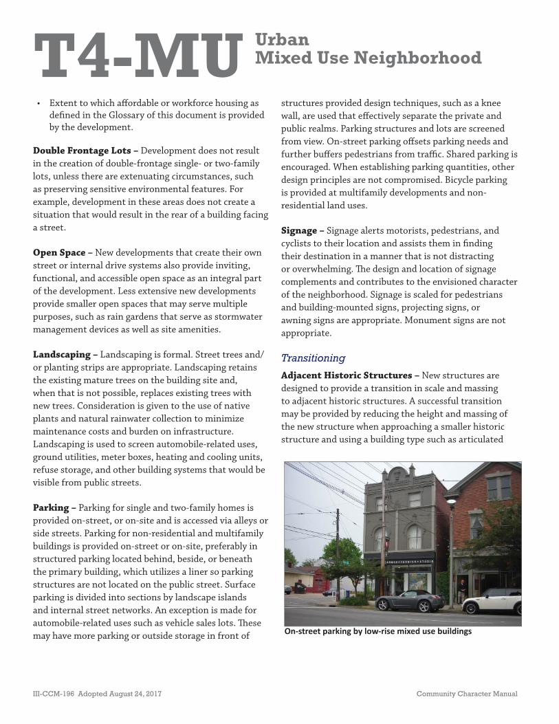
On-street parking by low-rise mixed use buildings
T4-MU UrbanMixed Use Neighborhood
Community Character Manual Adopted August 24, 2017 III-CCM-197
townhouses near historic structures to complement the historic structure’s form. Applicants are also encouraged to off er additional or alternative innovative ways to provide transition in scale, massing, and building type. In all cases, new structures adjacent to historic structures complement in height and massing historic structures and do not threaten the integrity of the historic property and its environment.
Higher Intensity – Buildings at the edges of the T4-MU form transitions in scale and massing where it adjoins lower-intensity policy areas, with thoughtful attention given to the placement and orientation of buildings within these edges as they relate to their surroundings. Implementation through rezoning occurs as proposals are judged on their merits and ability to meet the goals of the Community Plan. Buildings at the edges of T4-MU areas:
• Step down in height as they move closer to adjacent lower-intensity areas. Th is may require diff erent heights within an individual structure and/or more varied building types including courtyard fl ats, plex houses, detached accessory dwellings, etc.;
• Respond to diff erences in topography to avoid buildings that loom over lower-intensity buildings at lower elevations;
• Are oriented so that there is a back-to-back relationship between the higher-intensity buildings and lower-intensity buildings;
• Are separated from lower-intensity areas by rear alleys or service lanes; and
• Have articulated façades that face lower-intensity policy areas.
Connectivity
Access – Access to residential, commercial, offi ce, mixed use, and light industrial buildings is provided from alleys and side streets. Larger industrial uses are served by driveways. Shared access is used to avoid multiple curb cuts and pedestrian/vehicular confl ict points. Access is designed to be easily crossed by pedestrians. Access into
developments is aligned, where applicable, with access for development across the street. Cross access is provided between abutting developments. Coordinated access and circulation create an area that functions as a whole instead of as separate building sites.
Block Length – Blocks are linear with moderate to short distance between intersections.
Pedestrian/Bicycle – Pedestrian and bicycle connectivity is high and, where available, is provided in the form of sidewalks and bikeways. Pedestrian connectivity within T4-MU areas is high in order to allow residents, employees, and visitors to park and walk to multiple destinations and access existing or planned transit. Sidewalks are present within the neighborhood, and crosswalks are provided at intersections, across parking lots, and at vehicular access points and are clearly marked to distinguish the pedestrian zone from the vehicular zone.
Transit – Access to mass transit is provided in convenient locations that allows for coordination with sidewalks and bikeways. Development provides facilities to accommodate mass transit in the form of transit shelters and street cross sections that accommodate transit stops.
Vehicular – Vehicular connectivity is high and is provided in the form of local streets, collector-avenues, and arterial-boulevards that create a complete street network, and provide residents with multiple routes and reduced trip distances. Cul-de-sacs are inappropriate. Th e street network is complemented with an alley network that provides access to residential, mixed use, commercial, offi ce, and light industrial uses.
T4-MU UrbanMixed Use Neighborhood
III-CCM-198 Adopted August 24, 2017 Community Character Manual
Zoning
Th e following is a list of zoning districts that may be appropriate within a given T4-MU area subject to the applicant’s ability to prove that the requested zoning district is consistent with the other provisions of T4-MU policy that are detailed above. A site’s location in relation to centers and corridors will be weighed when considering which zoning districts would be appropriate in a given situation. Th e size of the site, environmental conditions on and near the site, and the character of adjacent Transect and policy areas, will be considered.
Another factor that will be considered is whether there is potential to redevelop sites that are not consistent with T4-MU policy in a manner that brings them closer to conforming to the policy. Th ese situations may warrant the use of zoning districts that the policy might otherwise consider inappropriate.
• MUN-A• MUL-A• OR20-A• OR40-A• RM9-A to RM40-A
Other alternative zoning districts may be appropriate based on locational characteristics and surrounding context of the subject property.
• Design-based zoning
Other existing or future zoning districts may be appropriate based on the locational characteristics of the subject property and the ability of the applicant to document that the proposed zoning district is consistent with the policy. Design-based zoning may be required to achieve planning objectives such as access management, coordination among adjacent developments, or to mitigate potential negative impacts to nearby environmentally sensitive features.
T4-NC UrbanNeighborhood Center
Community Character Manual Adopted August 24, 2017 III-CCM-199
Policy Intent
Maintain, enhance, and create urban neighborhood centers that provide daily needs and services for surrounding urban neighborhoods.
General Characteristics
Centers are generally at the intersection of two prominent roads and include infrastructure for pedestrians and bicyclists. T4 Urban Neighborhood Center areas have high levels of connectivity and complete street networks with sidewalks, bikeways, and existing or planned transit. Where transportation infrastructure is insuffi cient or not present, enhancements may be necessary to improve pedestrian, bicycle, and vehicular connectivity. T4-NC areas are pedestrian-friendly areas, generally located at intersections of urban streets and consist of the following:
• Commercial, mixed use, residential, and institutional land uses;
• Services to meet the daily needs of residents within a fi ve to ten minute walk;
• Intensity generally placed within edges, not exceeding the four corners of an intersection of prominent urban streets;
• Regularly spaced buildings built to the back edge of the sidewalk with minimal spacing between buildings;
• Parking behind or beside the buildings and generally accessed by side streets or alleys;
• Consistent use of lighting and formal landscaping;
• High levels of connectivity with complete street networks, sidewalks, bikeways, and existing or planned mass transit leading to surrounding neighborhoods and open space; and
• Clearly distinguishable boundaries identifi ed by land uses, building types, building placement, and block structure.
• RM9-A to RM20-A• OR20-A• MUN-A, MUL-A• Design-based zoning
ZONING*
• Mixed Use• Commercial• Offi ce• Ins tu onal• Offi ce• Residen al
EXAMPLES OF APPROPRIATE LAND USES*
*Disclaimer: Th is information is provided as an aid for general reference and should not be construed as all data that may apply to each property. Users should independently verify the accuracy of the information.
• Low-rise Townhouse• Mid-rise townhouse• Manor House• Courtyard Flat• Low-Rise Flat• Mid-Rise Flat• Low-Rise Mixed Use• Mid-Rise Mixed Use• Low-Rise Commercial• Ins tu onal
BUILDING TYPES
T4-NC UrbanNeighborhood Center
III-CCM-200 Adopted August 24, 2017 Community Character Manual
Application
T4-NC policy is applicable to areas where there is a concentration of land that is zoned, used, or intended to be used as mixed use and commercial. A center is situated to serve an urban neighborhood, and where the center’s intensifi cation is supported by surrounding existing or planned residential development, adequate infrastructure, and adequate access, such as the intersection of a local and collector-avenue street.
Commonly used boundaries to defi ne T4-NC areas include, but are not limited to: boundaries defi ned by evolving or intended development patterns (considering lot size, mass, spacing, orientation of buildings), environmental features, human-made features (rail lines, major utility easements, prominent roads and streets), and transitional uses (open space, institutional, ancillary residential). Intensifi cation should take place within the current boundaries of the center rather than through expansion of the policy area. Th e application and boundary delineation of this policy are established during the Community Planning process.
Design Principles
Building Form and Site Design
Th e building form is in character with the existing T4 Urban development pattern in terms of its mass, orientation, and placement. Th e building form also complements the adjacent neighborhoods that it serves and the infrastructure to which it has access.
A mix of building types is expected in T4-NC areas with preference given to mixed use buildings. Th ese buildings use land effi ciently and contribute to the vitality and function of the center by providing combined opportunities to live, work, and shop and by supporting both consumer business viability and the feasibility of public investments such as sidewalks and transit. Commercial, offi ce, institutional, and
residential buildings are also found. Locations at prominent intersections are reserved for mixed use or non-residential development unless the applicant can document an appropriate, planning-based reason for placing a solely residential building at such a location.
Massing – Th e massing of non-residential and mixed use buildings results in a footprint with moderate to high lot coverage. Th is may be achieved with individual, fi rst-fl oor tenant space of 10,000 square feet or less, each with its own entrance(s).
Additional individual fi rst-fl oor tenant space square footage may be considered in cases of exceptional development design that is especially attentive to:
• Strongly articulating the façade of larger buildings and including such elements as windows and multiple pedestrian entrances;
• Placing the parking in a manner that breaks up large expanses of pavement, provides for safe pedestrian movement, and deters speeding vehicles (parking standards below still apply);
• Orienting the large buildings and using smaller buildings to frame the large building all in a manner that creates a town center environment that serves as a destination within the center; and
• Providing one or more areas of publicly accessible, usable, and inviting open space.
Orientation – Buildings, including entrances, are oriented to the street. Developments at intersections are oriented so that buildings, including their main entrances, face the highest-order street at the intersection. Property consolidation to create larger development sites within the T4-NC area may be needed to achieve adequate dimensions for building and site design that is consistent with this policy category. Development within the transitions along side streets that are between the T4-NC and adjacent policy areas does not inhibit or discourage redevelopment of the properties on the higher-order street.
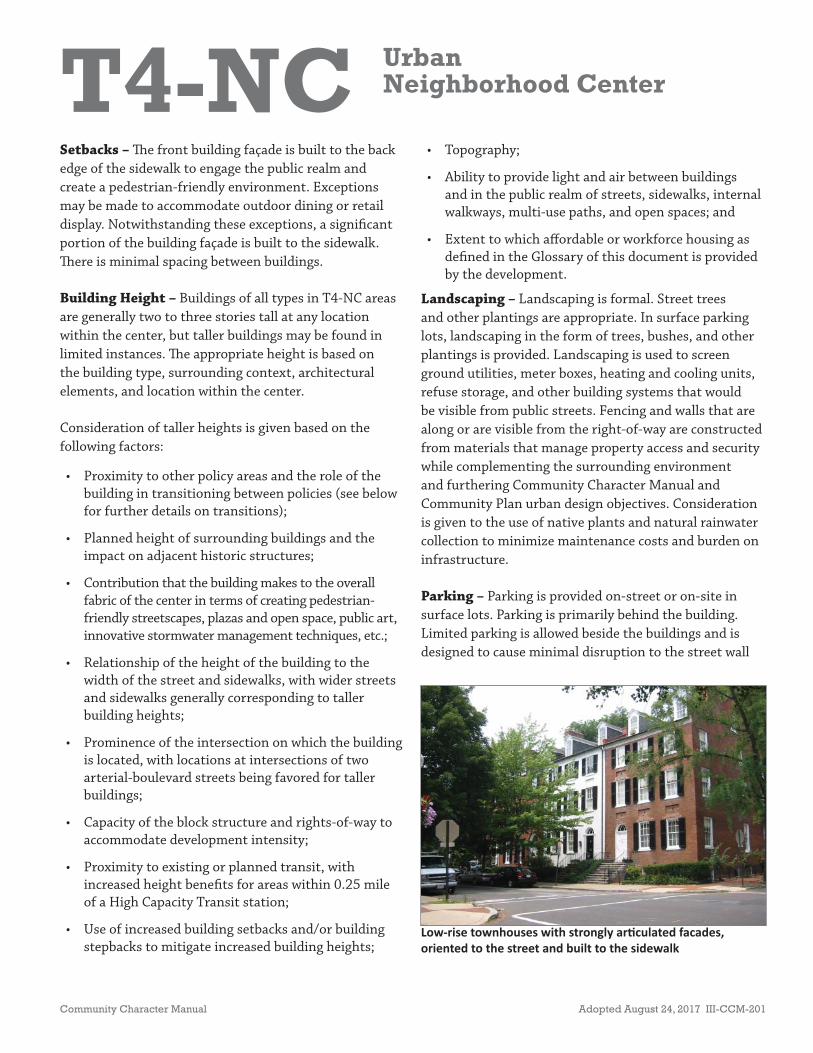
T4-NC UrbanNeighborhood Center
Community Character Manual Adopted August 24, 2017 III-CCM-201
Low-rise townhouses with strongly ar culated facades, oriented to the street and built to the sidewalk
Setbacks – Th e front building façade is built to the back edge of the sidewalk to engage the public realm and create a pedestrian-friendly environment. Exceptions may be made to accommodate outdoor dining or retail display. Notwithstanding these exceptions, a signifi cant portion of the building façade is built to the sidewalk. Th ere is minimal spacing between buildings.
Building Height – Buildings of all types in T4-NC areas are generally two to three stories tall at any location within the center, but taller buildings may be found in limited instances. Th e appropriate height is based on the building type, surrounding context, architectural elements, and location within the center.
Consideration of taller heights is given based on the following factors:
• Proximity to other policy areas and the role of the building in transitioning between policies (see below for further details on transitions);
• Planned height of surrounding buildings and the impact on adjacent historic structures;
• Contribution that the building makes to the overall fabric of the center in terms of creating pedestrian-friendly streetscapes, plazas and open space, public art, innovative stormwater management techniques, etc.;
• Relationship of the height of the building to the width of the street and sidewalks, with wider streets and sidewalks generally corresponding to taller building heights;
• Prominence of the intersection on which the building is located, with locations at intersections of two arterial-boulevard streets being favored for taller buildings;
• Capacity of the block structure and rights-of-way to accommodate development intensity;
• Proximity to existing or planned transit, with increased height benefi ts for areas within 0.25 mile of a High Capacity Transit station;
• Use of increased building setbacks and/or building stepbacks to mitigate increased building heights;
• Topography;
• Ability to provide light and air between buildings and in the public realm of streets, sidewalks, internal walkways, multi-use paths, and open spaces; and
• Extent to which aff ordable or workforce housing as defi ned in the Glossary of this document is provided by the development.
Landscaping – Landscaping is formal. Street trees and other plantings are appropriate. In surface parking lots, landscaping in the form of trees, bushes, and other plantings is provided. Landscaping is used to screen ground utilities, meter boxes, heating and cooling units, refuse storage, and other building systems that would be visible from public streets. Fencing and walls that are along or are visible from the right-of-way are constructed from materials that manage property access and security while complementing the surrounding environment and furthering Community Character Manual and Community Plan urban design objectives. Consideration is given to the use of native plants and natural rainwater collection to minimize maintenance costs and burden on infrastructure.
Parking – Parking is provided on-street or on-site in surface lots. Parking is primarily behind the building. Limited parking is allowed beside the buildings and is designed to cause minimal disruption to the street wall
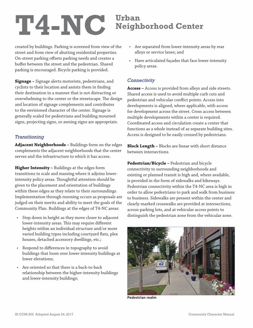
T4-NC UrbanNeighborhood Center
III-CCM-202 Adopted August 24, 2017 Community Character Manual
created by buildings. Parking is screened from view of the street and from view of abutting residential properties. On-street parking off sets parking needs and creates a buff er between the street and the pedestrian. Shared parking is encouraged. Bicycle parking is provided.
Signage – Signage alerts motorists, pedestrians, and cyclists to their location and assists them in fi nding their destination in a manner that is not distracting or overwhelming to the center or the streetscape. Th e design and location of signage complements and contributes to the envisioned character of the center. Signage is generally scaled for pedestrians and building mounted signs, projecting signs, or awning signs are appropriate.
Transitioning
Adjacent Neighborhoods – Buildings form on the edges complements the adjacent neighborhoods that the center serves and the infrastructure to which it has access.
Higher Intensity – Buildings at the edges form transitions in scale and massing where it adjoins lower-intensity policy areas. Th oughtful attention should be given to the placement and orientation of buildings within these edges as they relate to their surroundings. Implementation through rezoning occurs as proposals are judged on their merits and ability to meet the goals of the Community Plan. Buildings at the edges of T4-NC areas:
• Step down in height as they move closer to adjacent lower-intensity areas. Th is may require diff erent heights within an individual structure and/or more varied building types including courtyard fl ats, plex houses, detached accessory dwellings, etc.;
• Respond to diff erences in topography to avoid buildings that loom over lower-intensity buildings at lower elevations;
• Are oriented so that there is a back-to-back relationship between the higher-intensity buildings and lower-intensity buildings;
• Are separated from lower-intensity areas by rear alleys or service lanes; and
• Have articulated façades that face lower-intensity policy areas.
Connectivity
Access – Access is provided from alleys and side streets. Shared access is used to avoid multiple curb cuts and pedestrian and vehicular confl ict points. Access into developments is aligned, where applicable, with access for development across the street. Cross access between multiple developments within a center is required. Coordinated access and circulation create a center that functions as a whole instead of as separate building sites. Access is designed to be easily crossed by pedestrians.
Block Length – Blocks are linear with short distance between intersections.
Pedestrian/Bicycle – Pedestrian and bicycle connectivity to surrounding neighborhoods and existing or planned transit is high and, where available, is provided in the form of sidewalks and bikeways. Pedestrian connectivity within the T4-NC area is high in order to allow pedestrians to park and walk from business to business. Sidewalks are present within the center and clearly-marked crosswalks are provided at intersections, across parking lots, and at vehicular access points to distinguish the pedestrian zone from the vehicular zone.
Pedestrian realm
T4-NC UrbanNeighborhood Center
Community Character Manual Adopted August 24, 2017 III-CCM-203
Transit – Access to existing or planned mass transit is provided in convenient locations, coordinated with sidewalks and bikeways.
Vehicular – Vehicular connectivity to surrounding neighborhoods is high. Th e T4-NC area is generally located at an intersection of local and collector-avenue streets with vehicular access provided from alleys and side streets. Connectivity within the Center is provided through coordinated access and circulation.
Zoning
Th e following is a list of zoning districts that may be appropriate within a given T4-NC area subject to the applicant’s ability to prove that the requested zoning district is consistent with the other provisions of T4-NC policy that are detailed above. A site’s location in relation to centers and corridors will be weighed when considering which zoning districts would be appropriate in a given situation. Th e size of the site, environmental
conditions on and near the site, and the character of adjacent Transect and policy areas will be considered. Another factor that will be considered is whether there is potential to redevelop sites that are not consistent with T4-NC policy in a manner that brings them closer to conforming to the policy. Th ese situations may warrant the use of zoning districts that the policy might otherwise consider inappropriate.
• RM9-A to RM20-A• OR20-A• MUN-A• MUL-A• Design-based zoning
Other existing or future zoning districts may be appropriate based on the locational characteristics and surrounding context of the subject property and the ability of the applicant to document that the proposed zoning district is consistent with the policy. Design-based zoning may be required to achieve planning objectives such as access management, coordination among adjacent developments, or to mitigate potential negative impacts to nearby environmentally sensitive features.

T4-NC UrbanNeighborhood Center
III-CCM-204 Adopted August 24, 2017 Community Character Manual
PAGE LEFT INTENTIONALLY BLANK
T4-CC UrbanCommunity Center
Community Character Manual Adopted August 24, 2017 III-CCM-205
Policy Intent
Maintain, enhance, and create urban community centers. Encourage their development or redevelopment as intense mixed use areas that provide a mix of uses and services to meet the needs of the larger surrounding urban area.
General Characteristics
T4 Urban Community Centers (T4-CC) are served by multiple modes of transportation and accomodate sidewalks, bikeways, vehicles, and existing or planned transit. Where transportation infrastructure is insuffi cient or not present, enhancements may be necessary to improve pedestrian, bicycle, and vehicular connectivity.
T4-CC areas are suitable for creating services to meet the needs of surrounding neighborhoods. T4-CC areas are pedestrian-friendly, generally located at intersections of prominent urban streets and consist of the following:
• Commercial, mixed use, and institutional land uses, with residential land uses in mixed use buildings or serving as a transition to adjoining policy areas;
• Services to meet the daily needs of residents within a fi ve- minute drive or a fi ve- to ten- minute walk, as well as services that are needed less frequently and provide a draw to the larger community;
• Intensity generally placed within edges not exceeding a quarter-mile in diameter;
• Regularly spaced buildings built to the back edge of the sidewalk with minimal spacing between buildings;
• Parking behind or beside the building, or on-street;
• Consistent use of lighting and formal landscaping;
• Highly connected street networks, sidewalks, and existing or planned mass transit leading to surrounding neighborhoods and open space;
• MUL-A• MUG-A• OR20-A• OR40-A• ORI-A
• RM20-A• RM40-A• Design-based
zoning
ZONING*
• Mixed Use• Commercial• Offi ce• Ins tu onal• Transi onal Residen al• Ar san manufacturing and other low
impact industrial and warehousing uses
EXAMPLES OF APPROPRIATE LAND USES*
*Disclaimer: Th is information is provided as an aid for general reference and should not be construed as all data that may apply to each property. Users should independently verify the accuracy of the information.
• Low-rise Townhouse• Mid-rise townhouse• Courtyard Flat• Low-Rise Flat• Mid-Rise Flat• Low-Rise Mixed Use• Mid-Rise Mixed Use• Low-Rise Commercial• Ins tu onal
BUILDING TYPES
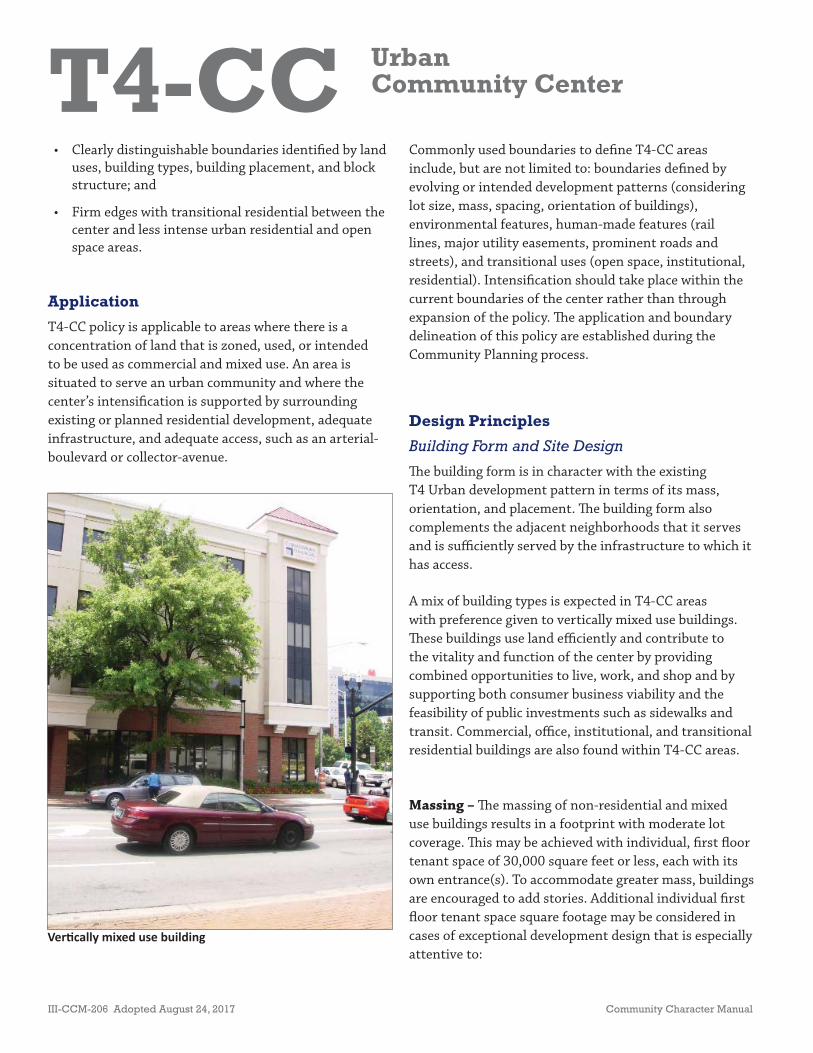
T4-CC UrbanCommunity Center
III-CCM-206 Adopted August 24, 2017 Community Character Manual
Ver cally mixed use building
• Clearly distinguishable boundaries identifi ed by land uses, building types, building placement, and block structure; and
• Firm edges with transitional residential between the center and less intense urban residential and open space areas.
Application
T4-CC policy is applicable to areas where there is a concentration of land that is zoned, used, or intended to be used as commercial and mixed use. An area is situated to serve an urban community and where the center’s intensifi cation is supported by surrounding existing or planned residential development, adequate infrastructure, and adequate access, such as an arterial-boulevard or collector-avenue.
Commonly used boundaries to defi ne T4-CC areas include, but are not limited to: boundaries defi ned by evolving or intended development patterns (considering lot size, mass, spacing, orientation of buildings), environmental features, human-made features (rail lines, major utility easements, prominent roads and streets), and transitional uses (open space, institutional, residential). Intensifi cation should take place within the current boundaries of the center rather than through expansion of the policy. Th e application and boundary delineation of this policy are established during the Community Planning process.
Design Principles
Building Form and Site Design
Th e building form is in character with the existing T4 Urban development pattern in terms of its mass, orientation, and placement. Th e building form also complements the adjacent neighborhoods that it serves and is suffi ciently served by the infrastructure to which it has access.
A mix of building types is expected in T4-CC areas with preference given to vertically mixed use buildings. Th ese buildings use land effi ciently and contribute to the vitality and function of the center by providing combined opportunities to live, work, and shop and by supporting both consumer business viability and the feasibility of public investments such as sidewalks and transit. Commercial, offi ce, institutional, and transitional residential buildings are also found within T4-CC areas.
Massing – Th e massing of non-residential and mixed use buildings results in a footprint with moderate lot coverage. Th is may be achieved with individual, fi rst fl oor tenant space of 30,000 square feet or less, each with its own entrance(s). To accommodate greater mass, buildings are encouraged to add stories. Additional individual fi rst fl oor tenant space square footage may be considered in cases of exceptional development design that is especially attentive to:

T4-CC UrbanCommunity Center
Community Character Manual Adopted August 24, 2017 III-CCM-207
Outdoor dining
• Strongly articulating the façade of large buildings and including such elements as windows and doors;
• Placing the parking in a manner that breaks up large expanses of pavement, provides safe pedestrian movement, and deters speeding vehicles (parking standards below still apply);
• Orienting the large buildings and using smaller buildings to frame the large buildings all in a manner that creates a town center environment that serves as a destination within the center; and
• Providing one or more areas of publicly accessible, usable, and inviting open space within the development.
Solely residential buildings in T4-CC areas are typically multifamily buildings with moderate to high lot coverage.
Orientation – Non-residential and mixed use buildings, including entrances, are oriented to the street. Façades are articulated with plentiful windows and doors. Additional design features such as recesses and awnings are used to break up long façades.
Residential buildings, including entrances, are oriented to the street or an open space, which may vary and could include courtyards or other types of functional and accessible open spaces.
Buildings at intersections, including their main entrances, face the highest-order intersecting street. Property consolidation to create larger development sites within the T4-CC policy area may be needed to achieve adequate dimensions for building and site design that is consistent with this policy category. Development within the transitions along side streets that are between the T4-CC and adjacent policy areas does not inhibit or discourage redevelopment of the properties on the higher-order street.
Setbacks – Setbacks are shallow and consistent, providing some distinction between the public realm of sidewalks, internal walkways, and open spaces and the private realm of the residence. Stoops and front porches are common to encourage some interaction between the public and private realm and to create a pedestrian-friendly environment. Courtyards for courtyard housing are appropriate.
Th e front building façade is built to the back edge of the sidewalk so that it engages the public realm and creates a pedestrian-friendly environment. Exceptions may be made to accommodate outdoor dining or retail display. Notwithstanding these exceptions, a signifi cant portion of the building façade is built to the sidewalk. Th ere is minimal spacing between buildings. Automobile-related uses that include outside storage or parking should provide knee walls or other design features to separate the public and private realms.
Building Height – Buildings of all types in T4-CC areas are generally three to fi ve stories tall but taller buildings may be found at major intersections along arterial-boulevards that are suffi ciently wide to avoid the eff ect of a building overshadowing the street; in Tiered Centers and along priority corridors. Th e appropriate height is based on the building type, surrounding context, architectural elements, and location within the center.
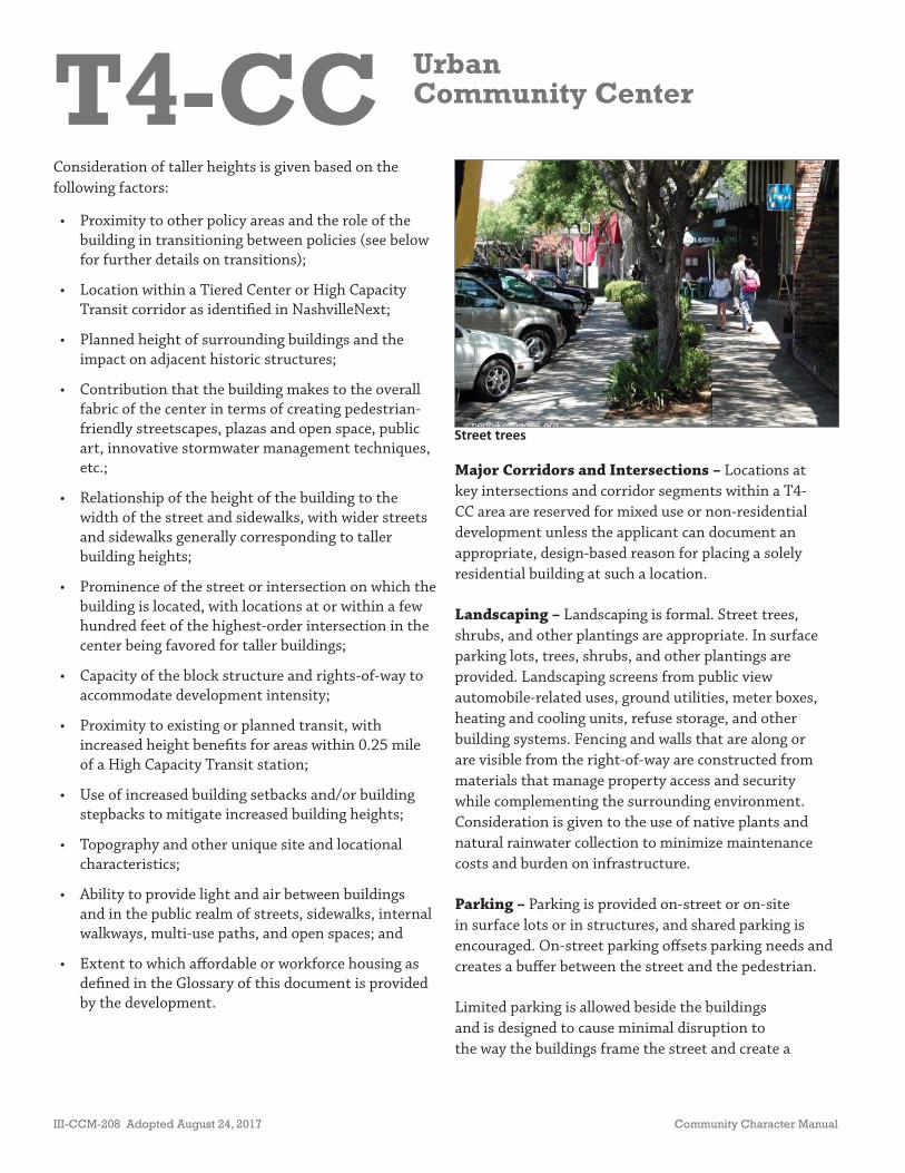
T4-CC UrbanCommunity Center
III-CCM-208 Adopted August 24, 2017 Community Character Manual
Consideration of taller heights is given based on the following factors:
• Proximity to other policy areas and the role of the building in transitioning between policies (see below for further details on transitions);
• Location within a Tiered Center or High Capacity Transit corridor as identifi ed in NashvilleNext;
• Planned height of surrounding buildings and the impact on adjacent historic structures;
• Contribution that the building makes to the overall fabric of the center in terms of creating pedestrian-friendly streetscapes, plazas and open space, public art, innovative stormwater management techniques, etc.;
• Relationship of the height of the building to the width of the street and sidewalks, with wider streets and sidewalks generally corresponding to taller building heights;
• Prominence of the street or intersection on which the building is located, with locations at or within a few hundred feet of the highest-order intersection in the center being favored for taller buildings;
• Capacity of the block structure and rights-of-way to accommodate development intensity;
• Proximity to existing or planned transit, with increased height benefi ts for areas within 0.25 mile of a High Capacity Transit station;
• Use of increased building setbacks and/or building stepbacks to mitigate increased building heights;
• Topography and other unique site and locational characteristics;
• Ability to provide light and air between buildings and in the public realm of streets, sidewalks, internal walkways, multi-use paths, and open spaces; and
• Extent to which aff ordable or workforce housing as defi ned in the Glossary of this document is provided by the development.
Street trees
Major Corridors and Intersections – Locations at key intersections and corridor segments within a T4-CC area are reserved for mixed use or non-residential development unless the applicant can document an appropriate, design-based reason for placing a solely residential building at such a location.
Landscaping – Landscaping is formal. Street trees, shrubs, and other plantings are appropriate. In surface parking lots, trees, shrubs, and other plantings are provided. Landscaping screens from public view automobile-related uses, ground utilities, meter boxes, heating and cooling units, refuse storage, and other building systems. Fencing and walls that are along or are visible from the right-of-way are constructed from materials that manage property access and security while complementing the surrounding environment. Consideration is given to the use of native plants and natural rainwater collection to minimize maintenance costs and burden on infrastructure.
Parking – Parking is provided on-street or on-site in surface lots or in structures, and shared parking is encouraged. On-street parking off sets parking needs and creates a buff er between the street and the pedestrian.
Limited parking is allowed beside the buildings and is designed to cause minimal disruption to the way the buildings frame the street and create a

T4-CC UrbanCommunity Center
Community Character Manual Adopted August 24, 2017 III-CCM-209
pedestrian-friendly environment. Parking is screened from view of the primary street(s) and from view of abutting residential properties. Surface parking is divided into sections by landscape islands and internal street networks. When establishing parking quantities, other design principles are not compromised. Bicycle parking is provided.
Parking is primarily behind the building. An exception is made for automobile-related uses such as vehicle sales lots. Th ese may have more parking or outside storage in front of structures provided design techniques, such as a knee wall, are used that eff ectively separate the private and public realms.
Signage – Signage alerts motorists, pedestrians, and cyclists to their location and assists them in fi nding their destination in a manner that is not distracting or overwhelming to the center or the streetscape. Th e design and location of signage complements and contributes to the envisioned character of the Center. Signage is generally scaled for pedestrians, and building-mounted signs, projecting signs, or awning signs are appropriate. In rare occasions, based on the use and classifi cation of the street, signage scaled for vehicles may be appropriate. In that case, monument signs are appropriate and are encouraged to be consolidated to the greatest extent possible.
Transitioning
Higher Intensity – Solely residential buildings may be used to provide a transition from higher-intensity commercial or mixed land uses in the center to adjacent lower-intensity residential land uses within a neighborhood.
Buildings at the edges form transitions in scale and massing where it adjoins lower-intensity policy areas. Th oughtful attention should be given to the placement and orientation of buildings within these edges as they relate to their surroundings. Implementation through rezoning occurs as proposals are judged on their merits and ability to meet the goals of the Community Plan.
Buildings at the edges of T4-CC areas:
• Step down in height as they move closer to adjacent lower-intensity areas. Th is may require diff erent heights within an individual structure and/or more varied building types including courtyard fl ats, plex houses, detached accessory dwellings, etc.;
• Avoid placing parking garage entrances and unlined parking structures opposite lower-intensity areas;
• Respond to diff erences in topography to avoid buildings that loom over lower-intensity buildings at lower elevations;
• Are oriented so that there is a back-to-back relationship between the higher-intensity buildings and lower-intensity buildings;
• Are separated from lower-intensity areas by rear alleys or service lanes; and
• Have articulated façades that face lower-intensity policy areas.
Connectivity
Access – Streets and alleys provide access. Shared access is used to avoid multiple curb cuts and pedestrian, bicyclist, and vehicular confl ict points. Access into developments is aligned, where applicable, with access for development across the street. Cross access between multiple developments within a center is required. Coordinated access and circulation create a center that functions as a whole instead of as separate building sites. Access is designed to be easily crossed by pedestrians.
As redevelopment occurs along the corridor, access from existing alleys is encouraged. Where an alley does not exist, the development of an alley system or adding to the existing alley system is also encouraged.
Th e impact of access to the corridor on adjacent neighborhoods is considered, balancing the impacts of increased traffi c with the need to provide connectivity to off er multiple route choices and spread traffi c to multiple streets.

T4-CC UrbanCommunity Center
III-CCM-210 Adopted August 24, 2017 Community Character Manual
T4-CC policy that are detailed above. A site’s location in relation to centers and corridors will be weighed when considering which zoning districts would be appropriate in a given situation. Th e size of the site, environmental conditions on and near the site, and the character of adjacent Transect and policy areas will be considered. Another factor that will be considered is whether there is potential to redevelop sites that are not consistent with T4-CC policy in a manner that brings them closer to conforming to the policy. Th ese situations may warrant the use of zoning districts that the policy might otherwise consider inappropriate.
• MUL-A• MUG-A• OR20-A• OR40-A• ORI-A• RM20-A• RM40-A
More intense alternative zoning districts may be appropriate based on locational characteristics of the subject property.
• Design-based zoning
Other existing or future zoning districts may be appropriate based on the locational characteristics and surrounding context of the subject property and the ability of the applicant to document that the proposed zoning district is consistent with the policy. Site plan-based zoning may be required to achieve planning objectives such as access management, coordination among adjacent developments, or to mitigate potential negative impacts to nearby environmentally sensitive features.
Block Length – Blocks are linear with short distances between intersections.
Pedestrian/Bicycle – Pedestrian and bicycle connectivity to surrounding neighborhoods and existing or planned transit is high and, where available, is provided in the form of sidewalks and bikeways. Pedestrian connectivity within the T4-CC area is high in order to allow pedestrians to park and walk from business to business. Sidewalks are present within the center, and crosswalks are provided at intersections, across parking lots, and at vehicular access points and are clearly marked to distinguish the pedestrian zone from the vehicular zone.
Transit – Access to existing or planned mass transit is provided in convenient locations coordinated with sidewalks and bikeways.
Vehicular – Vehicular connectivity to surrounding neighborhoods and corridors is high. Th e T4-CC area is generally located at an intersection of arterial-boulevards or an arterial-boulevard and a collector-avenue, with vehicular access provided from alleys and side streets. Connectivity within the center is provided through coordinated access and circulation, which may include the construction of new streets, drives, and alleys.
Zoning
Th e following is a list of zoning districts that may be appropriate within a given T4-CC area subject to the applicant’s ability to prove that the requested zoning district is consistent with the other provisions of

T4-RC UrbanResidential Corridor
Community Character Manual Adopted August 24, 2017 III-CCM-211
Policy Intent
Maintain, enhance, and create urban residential corridors that support predominately residential land uses and are compatible with the general character of urban neighborhoods.
General Characteristics
T4-RC areas are located on prominent arterial-boulevard and collector-avenue corridors that accommodate residential land uses and are served by multiple modes of transportation. Th ese prominent corridors may develop or redevelop over time to include higher density housing types. T4 Urban Residential Corridors (T4-RC) are served by multiple modes of transportation, moving vehicules effi ciently while accommodating sidewalks, bikeways, and existing or planned mass transit. Where transportation infrastructure is insuffi cient or not present, enhancements may be necessary to improve pedestrian, bicycle, and vehicular connectivity. T4-RC areas are intended to be “Complete Streets”—streets that are designed and operated to enable safe, attractive, and comfortable access and travel for all users. T4-RC areas are prominent due to their geographical location, size, scale, and/or accessibility by a variety of transportation modes.
Th ese corridors often provide the boundaries to urban neighborhoods or communities and are characterized by the following:
• A variety of residential and institutional buildings framing the corridor;
• Regularly spaced buildings with shallow setbacks and minimal spacing between buildings;
• Consistent use of lighting and formal landscaping;
• High access management, served by highly connected street networks, sidewalks, and existing or planned mass transit; and
• Firm edges with clearly distinguishable boundaries identifi ed by block structure and lot sizes of adjacent residential development.
• Residen al• Community Gardens & Other Open
Spaces• Ins tu onal
EXAMPLES OF APPROPRIATE LAND USES*
*Disclaimer: Th is information is provided as an aid for general reference and should not be construed as all data that may apply to each property. Users should independently verify the accuracy of the information.
• House• Plex House• Detached Acessory Dwelling Unit• House Court• Low-Rise Townhouse• Mid-Rise Townhouse• Manor House• Low-Rise Flat• Mid-Rise Flat• Ins tu onal
BUILDING TYPES
• RM15-A to RM40-A• Design-based zoning
ZONING*
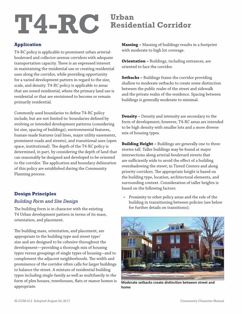
T4-RC UrbanResidential Corridor
III-CCM-212 Adopted August 24, 2017 Community Character Manual
Application
T4-RC policy is applicable to prominent urban arterial-boulevard and collector-avenue corridors with adequate transportation capacity. Th ere is an expressed interest in maintaining the residential use or creating residential uses along the corridor, while providing opportunity for a varied development pattern in regard to the size, scale, and density. T4-RC policy is applicable to areas that are zoned residential, where the primary land use is residential or that are envisioned to become or remain primarily residential.
Commonly used boundaries to defi ne T4-RC policy include, but are not limited to: boundaries defi ned by evolving or intended development patterns (considering lot size, spacing of buildings), environmental features, human-made features (rail lines, major utility easements, prominent roads and streets), and transitional uses (open space, institutional). Th e depth of the T4-RC policy is determined, in part, by considering the depth of land that can reasonably be designed and developed to be oriented to the corridor. Th e application and boundary delineation of this policy are established during the Community Planning process.
Design Principles
Building Form and Site Design
Th e building form is in character with the existing T4 Urban development pattern in terms of its mass, orientation, and placement.
Th e building mass, orientation, and placement, are appropriate to the building type and street type/size and are designed to be cohesive throughout the development—providing a thorough mix of housing types versus groupings of single types of housing—and to complement the adjacent neighborhoods. Th e width and prominence of the corridor often calls for larger buildings to balance the street. A mixture of residential building types including single-family as well as multifamily in the form of plex houses, townhouses, fl ats or manor homes is appropriate.
Moderate setbacks create dis nc on between street and home
Massing – Massing of buildings results in a footprint with moderate to high lot coverage.
Orientation – Buildings, including entrances, are oriented to face the corridor.
Setbacks – Buildings frame the corridor providing shallow to moderate setbacks to create some distinction between the public realm of the street and sidewalk and the private realm of the residence. Spacing between buildings is generally moderate to minimal.
Density – Density and intensity are secondary to the form of development; however, T4-RC areas are intended to be high density with smaller lots and a more diverse mix of housing types.
Building Height – Buildings are generally one to three stories tall. Taller buildings may be found at major intersections along arterial-boulevard streets that are suffi ciently wide to avoid the eff ect of a building overshadowing the street; in Tiered Centers and along priority corridors. Th e appropriate height is based on the building type, location, architectural elements, and surrounding context. Consideration of taller heights is based on the following factors:
• Proximity to other policy areas and the role of the building in transitioning between policies (see below for further details on transitions);
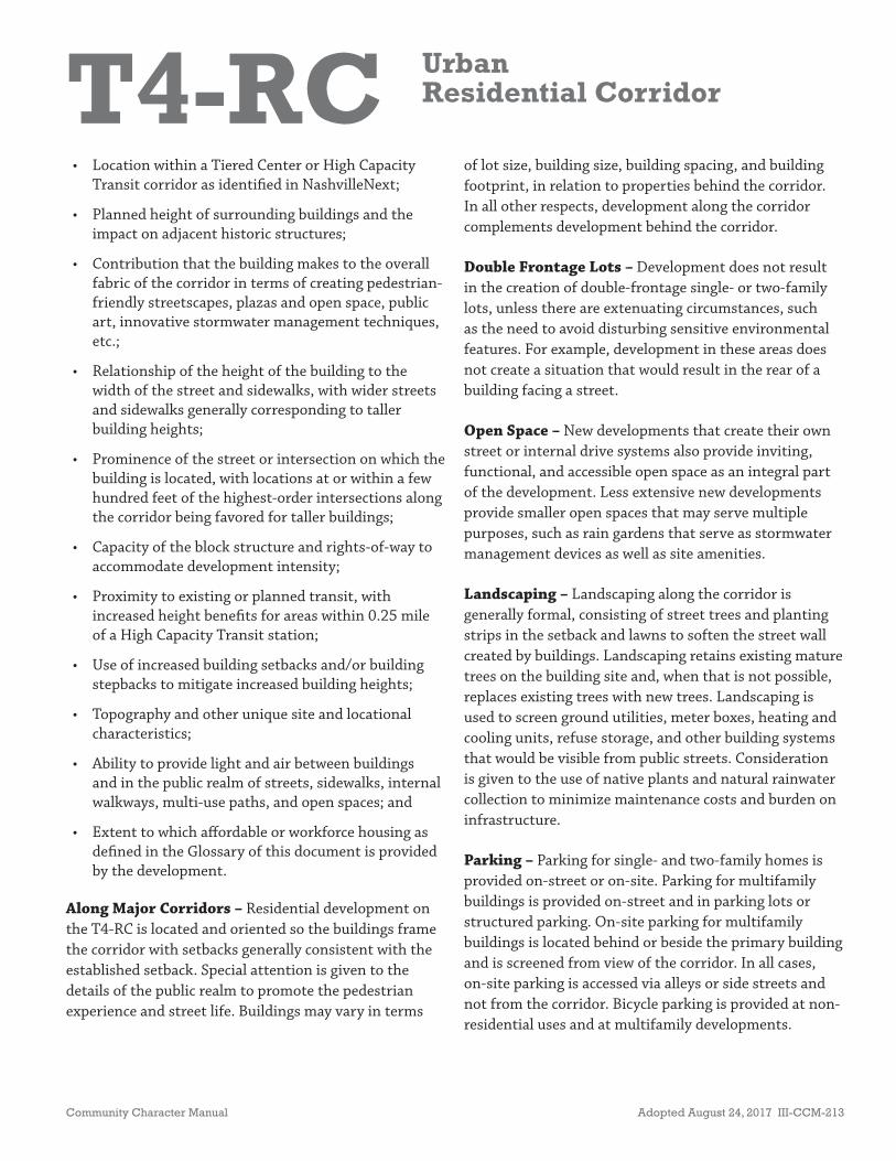
T4-RC UrbanResidential Corridor
Community Character Manual Adopted August 24, 2017 III-CCM-213
• Location within a Tiered Center or High Capacity Transit corridor as identifi ed in NashvilleNext;
• Planned height of surrounding buildings and the impact on adjacent historic structures;
• Contribution that the building makes to the overall fabric of the corridor in terms of creating pedestrian-friendly streetscapes, plazas and open space, public art, innovative stormwater management techniques, etc.;
• Relationship of the height of the building to the width of the street and sidewalks, with wider streets and sidewalks generally corresponding to taller building heights;
• Prominence of the street or intersection on which the building is located, with locations at or within a few hundred feet of the highest-order intersections along the corridor being favored for taller buildings;
• Capacity of the block structure and rights-of-way to accommodate development intensity;
• Proximity to existing or planned transit, with increased height benefi ts for areas within 0.25 mile of a High Capacity Transit station;
• Use of increased building setbacks and/or building stepbacks to mitigate increased building heights;
• Topography and other unique site and locational characteristics;
• Ability to provide light and air between buildings and in the public realm of streets, sidewalks, internal walkways, multi-use paths, and open spaces; and
• Extent to which aff ordable or workforce housing as defi ned in the Glossary of this document is provided by the development.
Along Major Corridors – Residential development on the T4-RC is located and oriented so the buildings frame the corridor with setbacks generally consistent with the established setback. Special attention is given to the details of the public realm to promote the pedestrian experience and street life. Buildings may vary in terms
of lot size, building size, building spacing, and building footprint, in relation to properties behind the corridor. In all other respects, development along the corridor complements development behind the corridor.
Double Frontage Lots – Development does not result in the creation of double-frontage single- or two-family lots, unless there are extenuating circumstances, such as the need to avoid disturbing sensitive environmental features. For example, development in these areas does not create a situation that would result in the rear of a building facing a street.
Open Space – New developments that create their own street or internal drive systems also provide inviting, functional, and accessible open space as an integral part of the development. Less extensive new developments provide smaller open spaces that may serve multiple purposes, such as rain gardens that serve as stormwater management devices as well as site amenities.
Landscaping – Landscaping along the corridor is generally formal, consisting of street trees and planting strips in the setback and lawns to soften the street wall created by buildings. Landscaping retains existing mature trees on the building site and, when that is not possible, replaces existing trees with new trees. Landscaping is used to screen ground utilities, meter boxes, heating and cooling units, refuse storage, and other building systems that would be visible from public streets. Consideration is given to the use of native plants and natural rainwater collection to minimize maintenance costs and burden on infrastructure.
Parking – Parking for single- and two-family homes is provided on-street or on-site. Parking for multifamily buildings is provided on-street and in parking lots or structured parking. On-site parking for multifamily buildings is located behind or beside the primary building and is screened from view of the corridor. In all cases, on-site parking is accessed via alleys or side streets and not from the corridor. Bicycle parking is provided at non-residential uses and at multifamily developments.

T4-RC UrbanResidential Corridor
III-CCM-214 Adopted August 24, 2017 Community Character Manual
Signage – Signage is limited to institutional uses and neighborhood identifi cation signs. Signage alerts motorists, pedestrians, and cyclists to their location and assists them in fi nding their destination in a manner that is not distracting or overwhelming to the streetscape. Th e design and location of signage complement and contribute to the envisioned character of the corridor. Signage is generally scaled for pedestrians and building mounted signs, projecting signs, or awning signs are appropriate. In rare occasions, based on the use and classifi cation of the street, signage scaled for vehicles may be appropriate. In that case, monument signs are appropriate and are encouraged to be consolidated to the greatest extent possible.
Transitioning
Adjacent Historic Structures – New structures are designed to provide a transition in scale and massing to adjacent historic structures. A successful transition may be provided by reducing the height and massing of the new structure when approaching a smaller historic structure and using a building type such as articulated townhouses near historic structures to complement the historic structure’s form. Applicants are also encouraged to off er additional or alternative innovative ways to provide transition in scale, massing, and building type. In all cases, new structures adjacent to historic structures complement in height and massing historic structures and do not threaten the integrity of the historic property and its environment.
Higher Intensity – Buildings at the edges of the T4-RC area form transitions in scale and massing where it adjoins lower-intensity policy areas. Th oughtful attention should be given to the placement and orientation of buildings within these edges as they relate to their surroundings. Implementation through rezoning occurs as proposals are judged on their merits and ability to meet the goals of the Community Plan. Buildings at the edges of T4-RC areas:
• Step down in height as they move closer to adjacent lower-intensity areas. Th is may require diff erent heights within an individual structure and/or more varied building types including detached accessory dwelling units, courtyard fl ats, plex houses, etc.;
• Avoid placing parking garage entrances and unlined parking structures opposite lower-intensity areas;
• Respond to diff erences in topography to avoid buildings that loom over lower-intensity buildings at lower elevations;
• Are oriented so that there is a back-to-back relationship between the higher-intensity buildings and lower-intensity buildings;
• Are separated from lower-intensity areas by rear alleys or service lanes; and
• Pay particular attention to articulating façades that face lower-intensity policy areas.
Connectivity
Access – T4-RC areas are intended to move vehicular traffi c effi ciently while accommodating sidewalks, bikeways, and existing or planned transit. High access management is observed. Th e existing block pattern should be maintained and not fragmented with driveways or additional streets, unless blocks are unusually long, in which case additional street intersections may be considered. On new corridors, shared and consolidated access points are provided at shorter distances from each other to complement the shorter urban block structure. Variation is allowed for sensitive treatment of environmental features.
Access to the corridor is provided preferably by side streets or existing driveways. New driveways are discouraged; but if permitted, they are shared or consolidated driveways. Curb cuts are limited and strategically located to minimize confl ict points between vehicles, pedestrians, and cyclists. As redevelopment occurs along the corridor, access from existing alleys
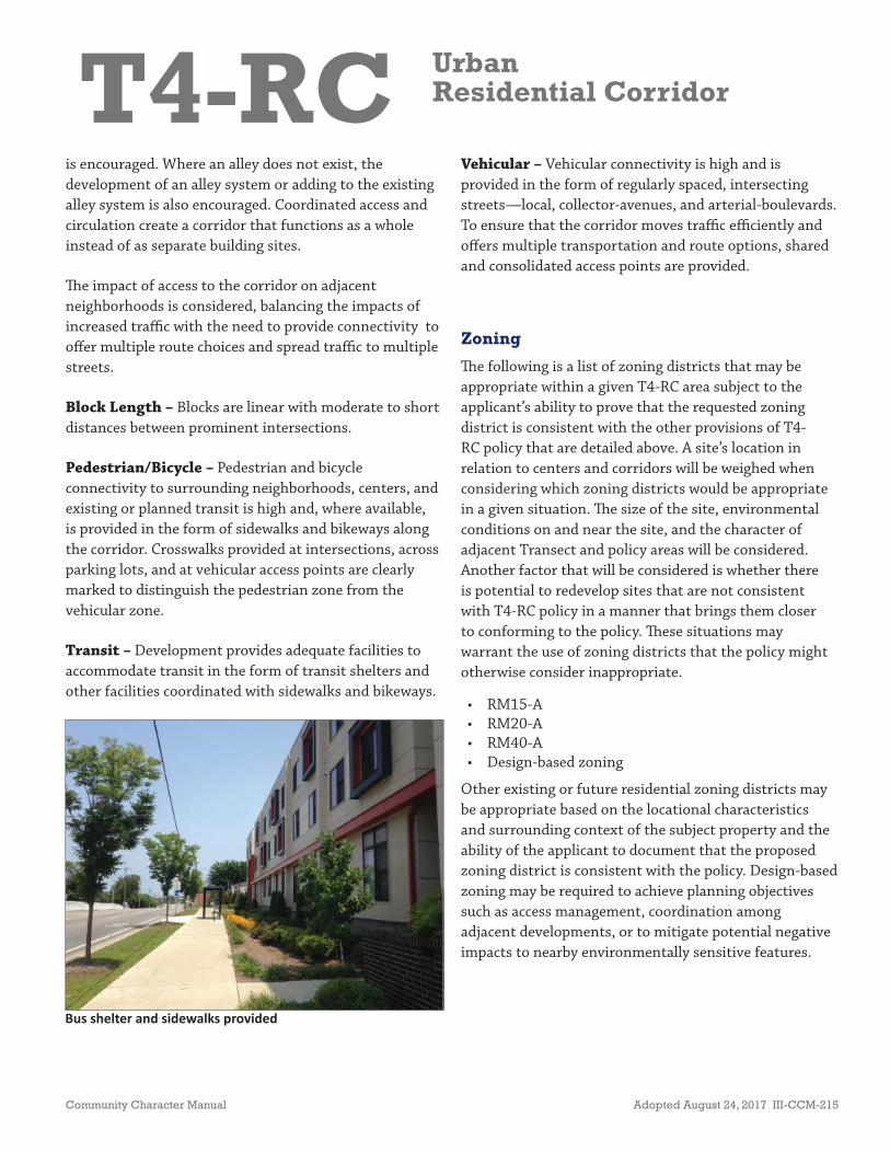
T4-RC UrbanResidential Corridor
Community Character Manual Adopted August 24, 2017 III-CCM-215
Bus shelter and sidewalks provided
is encouraged. Where an alley does not exist, the development of an alley system or adding to the existing alley system is also encouraged. Coordinated access and circulation create a corridor that functions as a whole instead of as separate building sites.
Th e impact of access to the corridor on adjacent neighborhoods is considered, balancing the impacts of increased traffi c with the need to provide connectivity to off er multiple route choices and spread traffi c to multiple streets.
Block Length – Blocks are linear with moderate to short distances between prominent intersections.
Pedestrian/Bicycle – Pedestrian and bicycle connectivity to surrounding neighborhoods, centers, and existing or planned transit is high and, where available, is provided in the form of sidewalks and bikeways along the corridor. Crosswalks provided at intersections, across parking lots, and at vehicular access points are clearly marked to distinguish the pedestrian zone from the vehicular zone.
Transit – Development provides adequate facilities to accommodate transit in the form of transit shelters and other facilities coordinated with sidewalks and bikeways.
Vehicular – Vehicular connectivity is high and is provided in the form of regularly spaced, intersecting streets—local, collector-avenues, and arterial-boulevards. To ensure that the corridor moves traffi c effi ciently and off ers multiple transportation and route options, shared and consolidated access points are provided.
Zoning
Th e following is a list of zoning districts that may be appropriate within a given T4-RC area subject to the applicant’s ability to prove that the requested zoning district is consistent with the other provisions of T4-RC policy that are detailed above. A site’s location in relation to centers and corridors will be weighed when considering which zoning districts would be appropriate in a given situation. Th e size of the site, environmental conditions on and near the site, and the character of adjacent Transect and policy areas will be considered. Another factor that will be considered is whether there is potential to redevelop sites that are not consistent with T4-RC policy in a manner that brings them closer to conforming to the policy. Th ese situations may warrant the use of zoning districts that the policy might otherwise consider inappropriate.
• RM15-A• RM20-A• RM40-A• Design-based zoning
Other existing or future residential zoning districts may be appropriate based on the locational characteristics and surrounding context of the subject property and the ability of the applicant to document that the proposed zoning district is consistent with the policy. Design-based zoning may be required to achieve planning objectives such as access management, coordination among adjacent developments, or to mitigate potential negative impacts to nearby environmentally sensitive features.

T4-RC UrbanResidential Corridor
III-CCM-216 Adopted August 24, 2017 Community Character Manual
PAGE LEFT INTENTIONALLY BLANK

T4-CM UrbanMixed Use Corridor
Community Character Manual Adopted August 24, 2017 III-CCM-217
Policy Intent
Enhance urban mixed use corridors by encouraging a greater mix of higher-density residential and mixed use development.
General Characteristics
T4 Urban Mixed Use Corridors (T4-CM) prioritize higher-intensity mixed use and commercial uses at intersections with preference given to residential uses between intersections. Streets move vehicular traffi c effi ciently while accommodating sidewalks, bikeways, and existing or planned mass transit. Where transportation infrastructure is insuffi cient or not present, enhancements may be necessary to improve pedestrian, bicycle, and vehicular connectivity.
T4-CM areas are pedestrian-friendly, prominent arterial-boulevard and collector-avenue corridors that accommodate residential, commercial, and mixed use development, and are served by multiple modes of transportation. T4-CM areas are intended to be “Complete Streets”—streets that are designed and operated to enable safe, attractive, and comfortable access and travel for all users. Th ese corridors are prominent due to their geographical location, size, scale, and/or accessibility by a variety of modes of transportation.
Th ese corridors often provide the boundaries to urban neighborhoods or communities and demonstrate the following characteristics:
• High density residential, commercial, and mixed use buildings;
• Regularly spaced buildings built to the back edge of the sidewalk with minimal spacing between buildings;
• Parking behind or beside the buildings and generally accessed by side streets or alleys;
• Consistent use of lighting and formal landscaping;
*Disclaimer: Th is information is provided as an aid for general reference and should not be construed as all data that may apply to each property. Users should independently verify the accuracy of the information.
• Mixed Use• Residen al• Commercial• Offi ce• Ins tu onal• Ar san manufacturing and other low
impact industrial and warehousing uses
EXAMPLES OF APPROPRIATE LAND USES*
• RM20-A• RM40-A• MUL-A• MUG-A• OR20-A
• OR40-A• ORI-A• Design-based
zoning
ZONING*
• Low-Rise Townhouse• Mid-Rise Townhouse• Courtyard Flat• Low-Rise Flat• Mid-Rise Flat• Low-Rise Mixed Use• Mid-Rise Mixed Use• Low-Rise Commercial• Ins tu onal
BUILDING TYPES
T4-CM UrbanMixed Use Corridor
III-CCM-218 Adopted August 24, 2017 Community Character Manual
• High access management, served by highly connected street networks, sidewalks, and mass transit; and
• Clearly distinguishable boundaries identifi ed by land uses, building types, building placement, and block structure.
Application
T4-CM policy is applicable to prominent urban arterial-boulevard and collector-avenue corridors with adequate transportation capacity. T4-CM policy is applied where there is an expressed interest in progressing to a balanced mixture of residential and commercial land uses along the corridor and providing opportunity for a varied development pattern in regard to the size, scale, and density. T4-CM policy is applicable to areas that are zoned residential, commercial, and mixed use, where the primary land use is residential, commercial, and mixed use, or that are envisioned to become predominately residential and mixed use with higher-intensity commercial areas concentrated at major intersections.
Commonly used boundaries to defi ne T4-CM policy areas include, but are not limited to: boundaries defi ned by evolving or intended development patterns (considering lot size, mass, spacing, orientation of buildings, spacing of buildings, etc.), environmental features, human-made features (rail lines, major utility easements, prominent roads and streets), and transitional uses (open space, institutional). Th e depth of the T4-CM policy is determined, in part, by considering the depth of land that can reasonably be designed and developed to be oriented to the corridor. Th e application and boundary delineation of this policy are established during the Community Planning process.
Design Principles
Building Form and Site Design
Th e building form is in character with the existing T4 Urban development pattern in terms of its mass, orientation, and placement. Th e building form also
complements the adjacent neighborhoods that it serves and the infrastructure to which it has access.
Massing – Th e massing of non-residential and mixed use buildings results in a footprint with moderate to high lot coverage. Th is may be achieved with individual, fi rst-fl oor tenant space of 10,000 square feet or less, each with its own entrance(s). To accommodate greater mass, buildings are encouraged to add stories. Additional individual fi rst fl oor tenant space square footage may be considered in cases of exceptional development design that is especially attentive to:
• Strongly articulating the façade of large buildings and including such elements as windows and doors;
• Placing the parking in a manner that breaks up large expanses of pavement, provides safe pedestrian movement, and deters speeding vehicles (parking standards below still apply);
• Orienting the large buildings and using smaller buildings to frame the large building all in a manner that creates a town center environment that serves as a destination; and
• Providing one or more areas of publicly accessible, usable, and inviting open space within the development.
Orientation – Non-residential and mixed use buildings, including entrances, are oriented to the corridor. Residential buildings, including entrances, are oriented to the street or an open space.
Multifamily residential buildings are preferred along corridor segments between intersections. Th ese multifamily buildings typically have moderate to high lot coverage. Façades are articulated with plentiful windows and doors. Additional design features such as recesses and awnings are used to break up long façades.
Developments at intersections are oriented so that buildings, including their main entrances, face the highest-order street at the intersection. Property consolidation to create larger development sites within

T4-CM UrbanMixed Use Corridor
Community Character Manual Adopted August 24, 2017 III-CCM-219
the T4-CM area may be needed to achieve adequate dimensions for building and site design that is consistent with this policy category. Development within the transitions along side streets that are between the T4-CM and adjacent policy areas does not inhibit or discourage redevelopment of the properties on the higher-order street.
Setbacks – Setbacks are shallow and consistent, providing some distinction between the public realm of sidewalks, internal walkways, and open spaces and the private realm of the residence. Stoops and front porches are common to encourage some interaction between the public and private realm and to create a pedestrian-friendly environment. Th ere is minimal spacing between buildings. Courtyards for courtyard fl ats are appropriate.
Th e front building façade is built to the back edge of the sidewalk so that it engages the public realm and creates a pedestrian-friendly environment. Exceptions may be made to accommodate outdoor dining or retail display. Notwithstanding these exceptions, a signifi cant portion of the building façade is built to the sidewalk. Automobile-related uses that include outside storage or parking provide knee walls or other design features to separate the public and private realms.
Density – Densities are signifi cantly higher than in surrounding residential neighborhoods.
Building Height – Buildings of all types in T4-CM areas are generally three to fi ve stories tall. Taller buildings may be found at major intersections along arterial-boulevard streets that are suffi ciently wide to avoid the eff ect of a building overshadowing the street; in Tiered Centers, and along priority corridors. Th e appropriate height is based on the building type, location, architectural elements, and surrounding context.
Consideration of taller heights is based on the following factors:
• Proximity to other Community Character Policies and the role of the building in transitioning between
policies (see below for further details on transitions);
• Location within a Tiered Center or High Capacity Transit corridor as identifi ed in NashvilleNext;
• Planned height of surrounding buildings and the impact on adjacent historic structures;
• Contribution that the building makes to the overall fabric of the center in terms of creating pedestrian-friendly streetscapes, plazas and open space, public art, innovative stormwater management techniques, etc.;
• Relationship of the height of the building to the width of the street and sidewalks, with wider streets and sidewalks generally corresponding to taller building heights;
• Prominence of the street or intersection on which the building is located, with locations at or within a few hundred feet of the highest-order intersections along the corridor being favored for taller buildings;
• Capacity of the block structure and rights-of-way to accommodate development intensity;
• Proximity to existing or planned transit, with increased height benefi ts for areas within 0.25 mile of a High Capacity Transit station;
• Use of increased building setbacks and/or building stepbacks to mitigate increased building heights;
• Topography and other unique site and locational characteristics;
• Ability to provide light and air between buildings and in the public realm of streets, sidewalks, internal walkways, multi-use paths, and open spaces; and
• Extent to which aff ordable or workforce housing as defi ned in the Glossary of this document is provided by the development.
Major Corridors and Intersections – A mix of building types is expected in T4-CM areas with preference given tomixed use buildings around intersections and multifamily residential buildings along corridor segments between intersections. Th ese buildings use land effi ciently and contribute to the vitality and function
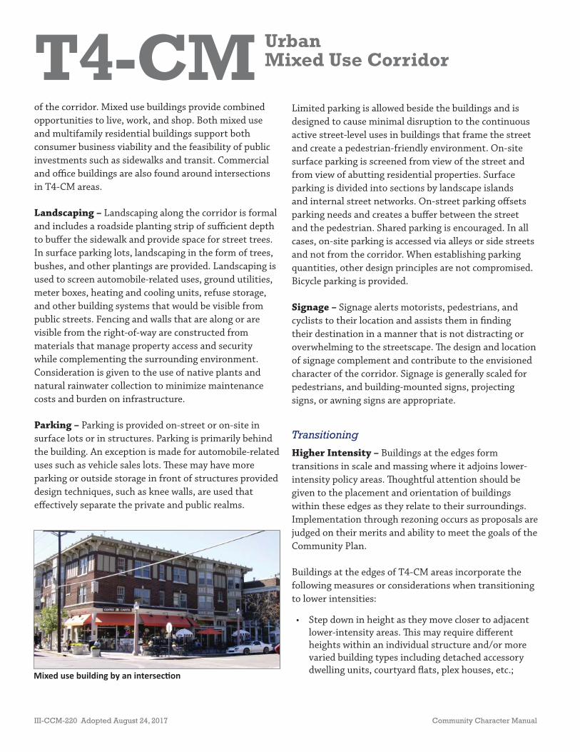
T4-CM UrbanMixed Use Corridor
III-CCM-220 Adopted August 24, 2017 Community Character Manual
Mixed use building by an intersec on
of the corridor. Mixed use buildings provide combined opportunities to live, work, and shop. Both mixed use and multifamily residential buildings support both consumer business viability and the feasibility of public investments such as sidewalks and transit. Commercial and offi ce buildings are also found around intersections in T4-CM areas.
Landscaping – Landscaping along the corridor is formal and includes a roadside planting strip of suffi cient depth to buff er the sidewalk and provide space for street trees. In surface parking lots, landscaping in the form of trees, bushes, and other plantings are provided. Landscaping is used to screen automobile-related uses, ground utilities, meter boxes, heating and cooling units, refuse storage, and other building systems that would be visible from public streets. Fencing and walls that are along or are visible from the right-of-way are constructed from materials that manage property access and security while complementing the surrounding environment. Consideration is given to the use of native plants and natural rainwater collection to minimize maintenance costs and burden on infrastructure.
Parking – Parking is provided on-street or on-site in surface lots or in structures. Parking is primarily behind the building. An exception is made for automobile-related uses such as vehicle sales lots. Th ese may have more parking or outside storage in front of structures provided design techniques, such as knee walls, are used that eff ectively separate the private and public realms.
Limited parking is allowed beside the buildings and is designed to cause minimal disruption to the continuous active street-level uses in buildings that frame the street and create a pedestrian-friendly environment. On-site surface parking is screened from view of the street and from view of abutting residential properties. Surface parking is divided into sections by landscape islands and internal street networks. On-street parking off sets parking needs and creates a buff er between the street and the pedestrian. Shared parking is encouraged. In all cases, on-site parking is accessed via alleys or side streets and not from the corridor. When establishing parking quantities, other design principles are not compromised. Bicycle parking is provided.
Signage – Signage alerts motorists, pedestrians, and cyclists to their location and assists them in fi nding their destination in a manner that is not distracting or overwhelming to the streetscape. Th e design and location of signage complement and contribute to the envisioned character of the corridor. Signage is generally scaled for pedestrians, and building-mounted signs, projecting signs, or awning signs are appropriate.
Transitioning
Higher Intensity – Buildings at the edges form transitions in scale and massing where it adjoins lower-intensity policy areas. Th oughtful attention should be given to the placement and orientation of buildings within these edges as they relate to their surroundings. Implementation through rezoning occurs as proposals are judged on their merits and ability to meet the goals of the Community Plan.
Buildings at the edges of T4-CM areas incorporate the following measures or considerations when transitioning to lower intensities:
• Step down in height as they move closer to adjacent lower-intensity areas. Th is may require diff erent heights within an individual structure and/or more varied building types including detached accessory dwelling units, courtyard fl ats, plex houses, etc.;
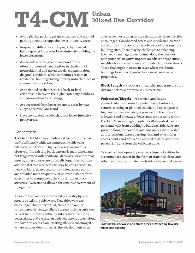
T4-CM UrbanMixed Use Corridor
Community Character Manual Adopted August 24, 2017 III-CCM-221
• Avoid placing parking garage entrances and unlined parking structures opposite lower-intensity areas;
• Respond to diff erences in topography to avoid buildings that loom over lower-intensity buildings at lower elevations;
• Are sensitively designed to respond to the often pronounced irregularities in the depth of nonresidential and mixed use development along diagonal corridors, which sometimes results in residential buildings facing directly onto the sides of commercial properties;
• Are oriented so that there is a back-to-back relationship between the higher-intensity buildings and lower-intensity buildings;
• Are separated from lower-intensity areas by rear alleys or service lanes; and
• Have articulated façades that face lower-intensity policy areas.
Connectivity
Access – T4-CM areas are intended to move vehicular traffi c effi ciently while accommodating sidewalks, bikeways, and transit. High access management is observed. Th e existing block pattern is maintained and not fragmented with additional driveways or additional streets, unless blocks are unusually long, in which case additional street intersections may be considered. On new corridors, shared and consolidated access points are provided more frequently, at shorter distance from each other to complement the shorter urban block structure. Variation is allowed for sensitive treatment of topography.
Access to the corridor is provided preferably by side streets or existing driveways. New driveways are discouraged; but if permitted, they are shared or consolidated driveways. Shared access limiting curb cuts is used to minimize confl ict points between vehicles, pedestrians, and cyclists. As redevelopment occurs along the corridor, access from existing alleys is encouraged. Where an alley does not exist, the development of an
alley system or adding to the existing alley system is also encouraged. Coordinated access and circulation create a corridor that functions as a whole instead of as separate building sites. Th ere may be challenges to balancing the need to manage access points along the corridor with potential negative impacts on adjacent residential neighborhoods when access is provided from side streets. Th ese challenges increase in cases where residential buildings face directly onto the sides of commercial properties.
Block Length – Blocks are linear with moderate to short distance between prominent intersections.
Pedestrian/Bicycle – Pedestrian and bicycle connectivity to surrounding urban neighborhoods, centers, existing or planned transit, and open space is high and, where available, is provided in the form of sidewalks and bikeways. Pedestrian connectivity within the T4-CM area is high in order to allow pedestrians to park and walk from building to building. Sidewalks are present along the corridor and crosswalks are provided at intersections, across parking lots, and at vehicular access points and are clearly marked to distinguish the pedestrian zone from the vehicular zone.
Transit – Development provides adequate facilities to accommodate transit in the form of transit shelters and other facilities coordinated with sidewalks and bikeways.
Crosswalks, sidewalks and street trees provided by low-rise mixed use building

T4-CM UrbanMixed Use Corridor
III-CCM-222 Adopted August 24, 2017 Community Character Manual
Vehicular – Vehicular connectivity is high. To ensure that the corridor moves traffi c effi ciently and off ers multiple transportation and route options, the T4-CM area has high connectivity in the form of regularly spaced, intersecting local, collector-avenue, and arterial-boulevard streets. To further improve connectivity, access points are preferably provided by existing intersecting local, collector-avenue, or arterial-boulevard streets. If intersecting streets are not available, then access drives from the Corridor are consolidated and improved to serve as a new street that connects to adjacent development and contributes to the overall street network. Curb cuts are limited to minimize confl ict points between vehicles, pedestrians, and cyclists.
Zoning
Th e following is a list of zoning districts that may be appropriate within a given T4-CM area subject to the applicant’s ability to prove that the requested zoning district is consistent with the other provisions of T4-CM policy that are detailed above. A site’s location in relation to centers and corridors will be weighed when considering which zoning districts would be appropriate in a given situation. Th e size of the site, environmental
conditions on and near the site, and the character of adjacent Transect and policy areas will be considered. Another factor that will be considered is whether there is potential to redevelop sites that are not consistent with T4-CM policy in a manner that brings them closer to conforming to the policy. Th ese situations may warrant the use of zoning districts that the policy might otherwise consider inappropriate.
• RM20-A• RM40-A• MUL-A• MUG-A• OR20-A• OR40-A • ORI-A• Design-based zoning
Other existing or future zoning districts may be appropriate based on the locational characteristics of the subject property and the ability of the applicant to document that the proposed zoning district is consistent with the policy. Design-based zoning may be required to achieve planning objectives such as access management, coordination among adjacent developments, or to mitigate potential impacts to nearby environmentally sensitive features.