CCCHAPTER HAPTERHAPTER 2:2:2: 2:2: … · CCCHAPTERHAPTERHAPTER 2:2:2: 2:2: QQQQQUUUALITYALITYALITY...
24
CHAPTER HAPTER HAPTER HAPTER HAPTER 2: 2: 2: 2: 2: WATER TER TER TER TER QUALITY ALITY ALITY ALITY ALITY AND AND AND AND AND FORESTRY ORESTRY ORESTRY ORESTRY ORESTRY ACTIVITIES CTIVITIES CTIVITIES CTIVITIES CTIVITIES Nonpoint source pollution remains a major challenge to meeting water quality standards and designated uses in much of the Nation. Chapter 1 defines and describes nonpoint source pollution. The potential for sediment delivery to streams is a long-term (beyond 2 years) concern from almost all forestry harvesting activities and from forest roads regardless of their level of use or age (i.e., for the life of the road). Other pollutants of significance, including nutrients, increased temperature, toxic chemicals and metals, organic matter, pathogens, herbicides, and pesticides, are also of concern, and problems associated with these other pollutants (in the context of forestry activities) generally do not extend beyond 2 years from the time of harvest or are associated with a specific activity, such as an herbicide application. Temperature effects might generally extend beyond 2 years because of the time necessary for regrowth to occur in harvested stream- side management areas (SMAs). Nevertheless, all of these pollutants have the potential to affect water quality and aquatic habitat and minimizing their delivery to surface waters and groundwater deserves serious consideration before and during forestry activities. Forest harvesting can also affect the hydrology of a watershed, and hydrologic alterations within a watershed also have the potential to degrade water quality. Forestry activities can also affect the habitats of aquatic species through physical disturbances caused by construction of stream crossings, equipment use within stream corridors, and placement of slash or other debris generated by forestry activities within streams. The effects of sediment and other pollutants on water quality in forested areas are discussed below. The effects of forestry activities on surface waters are of concern to EPA and state and local authorities because healthy, clean waters are important for aquatic life, drinking water, and recreational use. Surface waters and their ecology can be affected by inputs of sediment, nutrients, and chemicals, and by alterations to stream flow that can result from forestry activities. The purpose of implementing management measures and best manage- ment practices (BMPs) to protect surface waters during and after forestry activities is to protect important ecological conditions and characteristics of the surface waters in roaded and logged forested areas. These conditions vary with water body type, but in general the ecological conditions that management measures and BMPs are intended to protect include the following: • General water quality, by minimizing inputs of polluted runoff. • Water temperature, by ensuring an adequate (but not excessive) and appropriate amount of shade along shorelines and streambanks. • Nutrient balance, by providing for an adequate influx of carbon and nutrients that serve as the basis of aquatic food chains. • Habitat diversity, by ensuring that inputs of large organic debris to the aquatic system are appropriate for the system. National Management Measures to Control Nonpoint Source Pollution from Forestry 2-1
Transcript of CCCHAPTER HAPTERHAPTER 2:2:2: 2:2: … · CCCHAPTERHAPTERHAPTER 2:2:2: 2:2: QQQQQUUUALITYALITYALITY...
CCCCCHAPTERHAPTERHAPTERHAPTERHAPTER 2:2:2:2:2: WWWWWAAAAATERTERTERTERTER QQQQQUUUUUALITYALITYALITYALITYALITY ANDANDANDANDAND
FFFFFORESTRYORESTRYORESTRYORESTRYORESTRY AAAAACTIVITIESCTIVITIESCTIVITIESCTIVITIESCTIVITIES
Nonpoint source pollution remains a major challenge to meeting water quality standards and designated uses in much of the Nation. Chapter 1 defines and describes nonpoint source pollution. The potential for sediment delivery to streams is a long-term (beyond 2 years) concern from almost all forestry harvesting activities and from forest roads regardless of their level of use or age (i.e., for the life of the road). Other pollutants of significance, including nutrients, increased temperature, toxic chemicals and metals, organic matter, pathogens, herbicides, and pesticides, are also of concern, and problems associated with these other pollutants (in the context of forestry activities) generally do not extend beyond 2 years from the time of harvest or are associated with a specific activity, such as an herbicide application. Temperature effects might generally extend beyond 2 years because of the time necessary for regrowth to occur in harvested streamside management areas (SMAs). Nevertheless, all of these pollutants have the potential to affect water quality and aquatic habitat and minimizing their delivery to surface waters and groundwater deserves serious consideration before and during forestry activities. Forest harvesting can also affect the hydrology of a watershed, and hydrologic alterations within a watershed also have the potential to degrade water quality. Forestry activities can also affect the habitats of aquatic species through physical disturbances caused by construction of stream crossings, equipment use within stream corridors, and placement of slash or other debris generated by forestry activities within streams. The effects of sediment and other pollutants on water quality in forested areas are discussed below.
The effects of forestry activities on surface waters are of concern to EPA and state and local authorities because healthy, clean waters are important for aquatic life, drinking water, and recreational use. Surface waters and their ecology can be affected by inputs of sediment, nutrients, and chemicals, and by alterations to stream flow that can result from forestry activities. The purpose of implementing management measures and best management practices (BMPs) to protect surface waters during and after forestry activities is to protect important ecological conditions and characteristics of the surface waters in roaded and logged forested areas. These conditions vary with water body type, but in general the ecological conditions that management measures and BMPs are intended to protect include the following:
• General water quality, by minimizing inputs of polluted runoff.
• Water temperature, by ensuring an adequate (but not excessive) and appropriateamount of shade along shorelines and streambanks.
• Nutrient balance, by providing for an adequate influx of carbon and nutrients that serve as the basis of aquatic food chains.
• Habitat diversity, by ensuring that inputs of large organic debris to the aquaticsystem are appropriate for the system.
National Management Measures to Control Nonpoint Source Pollution from Forestry 2-1
Chapter 2: Water Quality and Forestry Activities
• Hydrologic processes, by limiting disturbances to stream flow patterns, both seasonal and annual.
A great deal has been learned over the past 20 to 30 years about effective ways to reduce nonpoint source pollution from forestry activities. Developing more effective ways to control nonpoint source pollution in forested settings requires a basic understanding of forest hydrology and how forestry activities affect it. This chapter discusses the hydrologic processes of forested watersheds, the interaction of forestry activities with those processes, the general causes of nonpoint source pollution due to forestry activities, the specific pollutants and water quality concerns related to forestry activities, and general approaches to reducing the generation of pollutants. The information helps the reader understand how the management measures and BMPs discussed in Chapter 3 can minimize nonpoint source pollution and why proper implementation of BMPs is so critical to maintaining water quality in our forests.
Forested Watershed Hydrology
A watershed is an area that, due to its natural drainage pattern, collects precipitation and deposits it into a particular body of water. In western regions of the country these land areas are often called “drainages,” and throughout the Nation they’re sometimes referred to as river or stream “basins” (CWP, 2000). Streamflow is a critical element in understanding watershed processes and the effects of land use on those processes because it is the primary medium through which water, sediment, nutrients, organic material, thermal energy, and aquatic species move.
Streamflow is produced by vadose zone flow and groundwater seepage. Vadose zone flow is the flow that occurs between the ground surface and saturated soil, or the water table where groundwater lies. Rainfall and snowmelt supply and replenish both, but in a forested area only a portion of rainfall and snowmelt reaches surface waters. A portion is evaporated back to the atmosphere from the surface of leaves, other vegetative surfaces, and the ground. Some is absorbed by vegetation and either metabolized or transpired back to the atmosphere; and another portion is retained by the soil. Factors such as climate, soil type, topography, elapsed time since the last precipitation event, and amount of vegetation determine the portion of rainfall or snowmelt that actually reaches surface waters. The same factors, as well as soil structure (for instance, the presence of macropores created by animals or decayed roots, etc.) and geomorphology (e.g., depth to bedrock and type of underlying rock), determine how quickly moisture that infiltrates the soil reaches surface waters. If soil is already saturated or the quantity of rainfall or snowmelt is sufficient to exceed the soil’s capacity to absorb moisture, surface runoff will occur, though it is not common in forested areas.
Surface runoff in a forested area is more likely to be caused by changes within a watershed than by excessive precipitation, and it is of concern because it has far more erosive power than subsurface flow. There is little storage of water that flows over a forest floor, whereas subsurface storage in soil can be substantial. For this reason, surface water flows down hillslopes more than 10 times faster than it flows through soil. Obstacles on the ground, such as leaf litter and woody debris, help slow surface runoff, but other factors can increase its velocity or volume. Such factors include a loss of vegetative cover that would contribute to evaporation and evapotranspiration, soil compaction, impervious surfaces, and cutslopes of roads or other soil disturbances where subsurface flow can be
National Management Measures to Control Nonpoint Source Pollution from Forestry 2-2
Chapter 2: Water Quality and Forestry Activities
transformed into surface flow. Both the extent to which precipitation is delivered directly to the ground and prevented from infiltrating the soil and the amount of subsurface flow that is converted to overland flow are important factors that can affect the timing and volume of streamflow. When more water is delivered to streams faster than usual, stream flow peaks sooner and higher than normal, and instream erosion can occur.
Stormflow response in small basins depends primarily on hillslope processes, whereas that in large basins depends primarily on the geomorphology of the stream channel network. Consequently, land use changes and other site factors as mentioned above (e.g., soil compaction) affect streamflow in small basins more than in large basins. In any watershed, however, streamflow response to a given rain event largely depends on the capacity of the vegetation and soil to intercept rainfall or snowmelt. Saturated soil and little vegetative cover would tend to lead to a much faster streamflow response than dry soil and complete vegetative cover.
Streamflow during a season, the variability of streamflow within a season, and the variability of streamflow between seasons strongly influence channel form and processes. These factors also strongly affect aquatic and riparian species. In a stable stream—that is, one in equilibrium—each channel segment carries off sediment contributed from upstream locations and from tributaries. When the sediment input rate is greater than the energy in the stream to carry off sediment, sediment accumulates and a channel aggrades. When a stream has more energy than what is necessary to carry the sediment the water is carrying, it can pick up extra sediment and incise the stream.
Forested riparian buffers can provide some measure of flow regulation under certain watershed conditions (Desbonnet et al., 1994). A primary way in which buffers reduce flow velocity is by slowing flow velocity and allowing absorption of water into soil. They also maintain streamside soils in a condition to absorb water by virtue of their extensive root systems that provide the soil structure necessary for a large quantity of absorption. Rainfall and runoff intensity, soil characteristics, hydrologic regime, and slope of the buffer and runoff source area are once again some of the factors that determine a forested riparian buffer’s ability to regulate stream flow. A narrow forested buffer on a steep, nonvegetated slope has little ability to regulate flow, whereas a wide forested buffer on a gentle, vegetated slope could help reduce peak flow levels and provide for dry season flow.
Forestry Activities and Forest Hydrology
When one factor in a system changes, other factors may be affected as well. In a forested watershed, logging has the effect of both compacting and loosening soils due to the construction and use of roads, use of heavy machinery, logs being dragged over the ground or otherwise transported to yarding areas, and vegetation being removed. Roads and road ditches, ruts on the ground, and areas cleared of leaf litter or other soil coverings create opportunities for water channelling and flow diversion, which, if not properly controlled and directed, can generate erosive flows. Thus, the disturbances caused by logging in a forested watershed can lead to hydrologic changes within the same watershed, which can in turn lead to nonpoint source pollution. Forestry activities and their potential effects on forest hydrology and water quality (through nonpoint source pollution) are discussed below.
National Management Measures to Control Nonpoint Source Pollution from Forestry 2-3
Chapter 2: Water Quality and Forestry Activities
A note on the concept of disturbance ecology is in order here. A forest is not an ecosystem that has been in perfect equilibrium from its beginning as a grassland to its mature state, modified only by the slow successional changes that occur naturally. Numerous disturbances occur along the way, ranging from those on a small scale (such as a treefall) to those on a large scale (such as a wildfire). Forests react to these disturbances in ways that can increase biodiversity and promote overall forest health. For many years people have managed forests—including protection from disturbance and unnatural disturbance (such as harvesting and altering land use)—without paying attention to the natural disturbance regime of the particular forest. An ecosystem approach to forest management is evolving as more is learned about natural disturbance, and forest management approaches are being developed that benefit both forests and people by creating disturbance in spatial and temporal patterns that closely resemble those of natural disturbances. Thus, forest management activities can be done such that the disturbances they cause benefit the forest ecosystem. Managing a forest this way, however, requires good knowledge of the forest ecosystem dynamics and consideration of all past, present, and future distur-bance-creating activities within the forest ecosystem that could cumulatively create more disturbance—and thus unintended damage—than the project being considered, for instance road construction or a harvest.
Road Construction and Road Use
Roads are generally considered to be the major source of sediment to water bodies from harvested forest lands. They have been found to contribute up to 90 percent of the total sediment production from forestry activities (Megahan, 1980; Patric, 1976; Rothwell, 1983). There is some evidence that modern road building practices, such as locating roads on ridgetops instead of middle slopes, removing excavated material to an offsite location, and using full bench construction is reducing the amount of sediment delivered to streams from forest roads (Copstead, 1997). Erosion from roads can be disproportionately high because roads lack vegetative cover, are exposed to direct rainfall, have a tendency to channel water on their surfaces, and are disturbed repeatedly when used. Erosion from roads can be exacerbated by instability on cut-and-fill slopes, water flow over the road surface or through a roadside ditch, flow from surrounding areas becoming concentrated and channelled by a road surface, and lack of a protective surfacing. Much of the sediment load to streams that is associated with roads can be attributed to older roads, which may have been constructed with steep gradients and deep cut-and-fill sections and which may have poorly maintained drainage structures.
Numerous factors need to be considered to protect water quality from the potential effects of forest roads. Stream crossings of both older and modern forest roads and old forest roads that were placed near streams are the most troublesome source of sediment to streams. While roads contribute more to erosion on forested land on a per-area basis (e.g., quantity of eroded soil per acre of road versus per acre of undisturbed forest), they also occupy a disproportionately small amount of a forested area. Evidence indicates that the total amount of eroded soil from roads is not much if any greater than the total amount of soil eroded from the non-roaded surface of a forested area (Gucinski et al., 2001). A related factor is that a small percentage of road area may be responsible for most of the erosion from roads. Rice and Lewis (1986, cited in Gucinski et al., 2001) found that major erosional features of roads occupied only 0.6 percent of the length of roads. A final factor to consider is that soil loss from roads tends to be greatest during and immediately after road construction because of the unstabilized road prism and
National Management Measures to Control Nonpoint Source Pollution from Forestry 2-4
Chapter 2: Water Quality and Forestry Activities
disturbance by passage of heavy trucks and equipment (Swift, 1984). Consideration of these factors to reduce water pollution from roads is provided in Chapter 3, section C, Road Construction/Reconstruction, and section D, Road Management.
Careful planning and proper road layout and design, however, can minimize erosion and substantially reduce the effects of roads on streams. The effect that a forest road network has on sediment input and flow changes in stream networks depends in part on how interconnected the road and stream networks are. Roads generally are hydrologically connected to stream networks where subsurface groundwater flow is converted to channelled overland flow at road cuts, and road surface runoff drains directly to stream channels. Overland flow is delivered to streams much more quickly than subsurface flow, so the conversion of subsurface flow to overland flow and the connectivity of road networks to stream networks can have an effect on stormflow patterns in streams (Jones and Grant, 1996; Montgomery, 1994; Wemple et al., 1996). Careful road system planning, taking watershed processes, soil type, topography, and vegetative characteristics into account, and designing with natural drainage patterns to minimize hydrologic connections of the road network to streams and maximize opportunities for filtering surface drainage, can reduce these effects. Chapter 3, section A, Preharvest Planning, discusses these factors.
Timber Harvesting
Timber harvesting generally involves the use of forest roads (the effects of which are discussed separately above and in Chapter 3), skid trails (along which felled trees are dragged), yarding areas (where cut timber is collected for transport away from the harvest site), and machinery associated with harvesting, skidding, and yarding. Soil disturbance, soil compaction, and vegetation removal on the harvest site, skid trails, and yarding areas can contribute to water quality problems. Methods for minimizing the water quality effects of timber harvesting are discussed in Chapter 3, section E, Timber Harvesting.
The association between timber harvesting—especially clear-cut harvesting—and mass erosion events has been and continues to be controversial. Studies of landslides done up to the 1980s, primarily in the Pacific Northwest, found an association between clear-cutting and landslides, but the findings of the studies were inconclusive due to the way data were collected (Hockman-Wert, undated). Studies were often conducted using aerial photographs and concentrated on the steepest slopes. Aerial images cannot account for mass erosion that occurs under forest cover, and later research indicated that as much as 50 percent of mass erosion movements are unaccounted for on aerial photographs. While some studies found clear-cuts to lead to more landslides on steep slopes, when more gentle slopes were investigated the occurrence of landslides was found to be as common on forested sites as on clear-cut sites.
There is a general consensus that harvesting on steep slopes increases the landslide hazard for a period of time after the harvest. It is not clear, however, whether more or larger landslides occur due to harvesting. In an issue paper written for the Oregon Board of Forestry and to provide background information for policy decisions related to harvesting and public safety, Mills and Hinkle (2001) discuss the latest scientific evidence related to landslides and timber harvesting. They report that in three of four study areas higher landslide densities were found in stands that had been harvested within the previous nine years than in mature (i.e., more than 100 years old) forest stands, and that stands 30 to 100 years old had lower landslide densities than mature stands. They also report that the studies showed that average landslide volume was similar regardless of stand age.
National Management Measures to Control Nonpoint Source Pollution from Forestry 2-5
Chapter 2: Water Quality and Forestry Activities
Furthermore, landslides are known to be natural occurrences and important elements in stream ecology in that they are a primary means by which wood and gravel are delivered to streams to create fish habitat (Shaffer, undated). It may be, then, that landslides occur in steep areas regardless of land use history, but that harvesting may concentrate the occurrence of landslides into the 10 years after harvesting.
Geology, soil type, soil depth, and topography might have much more to do with determining whether a site is susceptible to landslides than land use history (Shaffer, nd). Underlying geology plays a role because porous bedrock drains water from soils quickly, while impermeable bedrock keeps water in the soil. Different types of bedrock, such as shales or granite, weather into different types of soils that will either promote or resist sliding. Soil type determines whether a soil binds well to itself and to bedrock to resist sliding or is easily dislodged to promote sliding. Soil depth determines how much soil volume there is above bedrock to absorb water before the soil becomes saturated and what the weight of soil available for sliding is. Water contributes to sliding not only by acting as a lubricant between soil and bedrock, but also by adding considerable weight to the soil. Two inches of rain in 24 hours adds 10 pounds of water in every square foot of soil. On flat topography, saturated soil will result in puddling or overland flow. On gently sloping topography, soil might “creep” downhill at the rate of a few inches a year. On steep topography, the combined weight of water and soil under saturated conditions can trigger a slide. Finally, vegetation provides soil binding to resist sliding, and root decay can make soils less cohesive. Root cohesion—the ability of roots to hold soil to a slope— is at its lowest about 10 years after a harvest (or some other event that kills trees, such as a wind storm after an ice storm). Depending on all of these factors—geology, soil type, soil depth, and topography, combined with the elements of precipitation and land use history—a landslide could occur before or after soil becomes saturated, before or after a harvest, and either slowly and progressively or suddenly and massively.
Finally, research on the effectiveness of different harvesting methods (e.g., clear-cutting or selective cutting) or logging practices to reduce landslide occurrence does not exist (Mills and Hinkle, 2001). The effectiveness of BMPs for minimizing the hazard of landslides from timber harvest sites is also not known.
Recent research in Canada has demonstrated that clear-cut harvesting can lead to increased mercury concentrations in runoff (McIlroy, 2001). Mercury is carried through the atmosphere from areas with sources such as coal combustion and incinerators, and can be deposited in forested areas. When those forested areas are clear-cut harvested, the additional runoff generated after the trees are removed might lead to increased mercury concentrations in the runoff. The Canadian study indicated that the effect is accentuated by heavy, clear-cut harvesting in large watersheds, and that the problem might be avoided by selective harvesting. Further study of the potential problem is needed to clearly portray the association, if any, between forest harvesting and mercury.
Another potential adverse effect of timber harvesting is an increase in stream water tem-perature—a water quality criterion for physical water quality—that can result if too much streamside vegetation is removed. Small streams are affected more by a loss of shade than are large streams. One reason that streamside buffer strips, or SMAs, are maintained is to minimize or prevent water temperature increases. Stream temperature maintenance is important for aquatic biota. For instance, stream temperature has been found to affect the time required for salmonid eggs to develop and hatch (Chamberlin et al., 1991). Fish and
National Management Measures to Control Nonpoint Source Pollution from Forestry 2-6
Chapter 2: Water Quality and Forestry Activities
aquatic invertebrates are cold-blooded adapted to ranges of water temperature, and can be adversely affected by the water temperature exceeding the high temperature of the range for which they are adapted. Maintaining streamside vegetation in an amount sufficient to provide shade that maintains the stream temperature within the proper range is a key goal of the Streamside Management Area Management Measure (see Chapter 3, section B, Streamside Management Areas).
Timber harvesting along a stream can also affect stream ecology by removing overhanging trees and branches from which twigs, leaves, branches, and sometimes entire trees fall into the stream channel. Overhanging vegetation contributes organic material in the form of leaves and needles, and large woody debris, or LWD, to surface waters. These materials serve as a source of energy and provide nutrients for aquatic life and provide habitat diversity. They are a primary source of nutrients in small, low-order streams high in watersheds where aquatic vegetation might not be abundant and upstream sources of nutrients are limited. Farther downstream, instream sources of nutrients, such as aquatic plants and organic matter transported from upstream sources, are more abundant and organic debris from overhanging trees is a less important source of energy and nutrients. LWD is still important in these streams, however, for the habitat diversity it creates. LWD creates eddies, provides shelter and anchoring points for small aquatic animals, and forms areas of relatively calm water in flowing streams and rivers. SMAs protect these important ecological processes and benefits, without which stream waters might be prevented from attaining the water quality criterion of supporting aquatic life.
Site Preparation and Forest Regeneration
Site preparation is done to prepare a harvested site for regeneration. It can be accomplished mechanically using wheeled or tracked machinery, by the use of prescribed burning, or with applications of chemicals (herbicides, fertilizers, and pesticides). These techniques may be used alone or in combination. These operations can affect water quality if chemicals used and/or spilled during site preparation operations or soils disturbed during site preparation are transported to surface waters.
The chemicals associated with forestry operations that are of most concern from a water quality perspective are petroleum compounds, lubricants, and other machinery-related chemicals. Herbicides, pesticides, and fertilizers pose little threat to water quality if used and applied according to the specific directions for the chemical being applied and state and EPA guidelines. The herbicides and pesticides used in forestry operations are generally specific to the target vegetation and pose little threat to aquatic organisms, and they generally are short-lived in the environment. Fertilizers pose little threat to aquatic environments because they are used very infrequently for forestry operations, perhaps as little as two applications on a harvest site in 50 years.
Mechanical site preparation by large tractors that shear, disk, drum-chop, or root-rake a site can result in considerable soil disturbance over large areas (Beasley, 1979). Site preparation techniques can result in the removal of vegetation left after a harvest and forest litter, soil compaction and a loss of infiltration capacity, and soil exposure and disturbance. All of these effects can lead to increased erosion and sedimentation. They are most pronounced soon after a harvest and decrease over time, usually within 2 years, as vegetative cover returns to the harvested site.
National Management Measures to Control Nonpoint Source Pollution from Forestry 2-7
Chapter 2: Water Quality and Forestry Activities
Forest regeneration methods can be divided into two general types: (1) regeneration from sprouts and seedlings, either planted seedlings or those present naturally on a harvest site, and (2) regeneration from seed, which can be natural seed in the soil or seed from a broadcast application after a harvest. Loss of soil from a harvest site is obviously undesirable from a water quality perspective, and also because of the lowered soil productivity and tree regeneration that can result. Protecting a harvest site from undue disturbance during site preparation, therefore, is desirable both from water quality (reduced erosion) and site productivity perspectives. Means to protect soils from erosion and undue disturbance during site preparation and forest regeneration are discussed in Chapter 3, section F, Site Preparation and Forest Regeneration, and section H, Revegetation of Disturbed Areas.
Prescribed Burning
Prescribed burning is a method used to prepare a site for regeneration after a harvest, however because the methods for minimizing water quality effects due to fire are somewhat specialized, it is treated separately in this document (see Chapter 3, section G, Fire Management). Prescribed burning of slash can increase erosion on some soils by eliminating protective cover and altering soil properties (Megahan, 1980). Burning can have the effect of making some soils water repellent, which will tend to increase runoff (Reid, 1993; Ziemer and Lisle, 1998). This effect can penetrate to a depth of 6 inches and persist for 6 or more years after a fire. Burning enhances infiltration in other soils. Which soils will be affected in what way cannot be consistently predicted, and the effect is evidently dependent on the type of vegetation in the area burned. Burning also releases nutrients, immediately increasing nitrogen available to plants, but produces an overall effect of decreasing nitrogen in the forest floor (Reid, 1993). Little effect occurs on soils not affected by fire.
The degree of erosion following a prescribed burn depends on soil erodibility; slope; timing, volume, and intensity of precipitation after a burn; fire severity; cover remaining on the soil; and speed of revegetation. Erosion resulting from prescribed burning is generally less than that resulting from roads and skid trails and from site preparation techniques that cause severe soil disturbance (Golden et al., 1984). However, serious erosion can occur following a prescribed burn if the slash being burned is collected or piled and soil on the harvest site is disturbed in the process of preparing for the burn.
The effects of fire on a watershed depend on burn severity and hydrologic events that follow a fire (Robichaud et al., 2000). Burn severity is related to the amount of vegetation loss and heat-related changes in soil chemistry due to a fire. In general, wildfire has a more severe effect on watershed processes than prescribed burning because it is more intense than a prescribed burn. Prescribed burns are generally set under conditions such that they can be controlled and the fire will burn lower and less intensely than would a wildfire. Given the potential effects that a severe burn can have on watershed processes, prescribed burning can be used effectively both for site preparation and to reduce the chances of wildfire—and the often more severe effects that the latter can have on watershed processes.
Forestry Pollutants and Water Quality Effects
The discussion above focused on forestry activities, the potential they have for generating nonpoint source pollution and pollutants, and the watershed processes that can be affected
National Management Measures to Control Nonpoint Source Pollution from Forestry 2-8
Chapter 2: Water Quality and Forestry Activities
by forestry activities. Below is a discussion of the pollutants that can be generated from forestry activities and the potential effects that these pollutants can have on water quality.
The nonpoint source pollution problem of greatest concern with respect to forestry activities is the addition of sediment to surface waters. Without adequate precautions, however, many water quality issues can arise from forestry operations:
• Sediment concentrations can increase because of accelerated erosion.
• Nutrients in water can increase after their release from decaying organic matter on the ground or in the water, or after a prescribed burn.
• Organic and inorganic chemical concentrations can increase because of harvesting and fertilizer and pesticide applications.
• Slash and other organic debris can accumulate in waterbodies, which can lead todissolved oxygen depletion.
• Water temperatures can increase because of removal of riparian vegetation.
• Streamflow can increase because of reduced evapotranspiration and runoff channeling.
The discussions below of the individual pollutants that can be generated by forestry activities present the range of effects that might occur during and after road construction or use or a harvest. The particular effects of a forestry activities in a specific watershed will depend on the unique interaction of the characteristics of the area where the activities occur, time of year, harvesting method, and the BMPs used.
Sediment
Sediment deposited in surface waters is of concern in this guidance because of its potential to affect instream conditions and aquatic communities. Sediment is the pollutant most associated with forestry activities. Sediment is the solid material that is eroded from the land surface by water, ice, wind, or other processes and then transported or deposited away from its original location. Soil is lost from the forest floor by surface erosion or mass wasting (for example, landslides).
Surface erosion generally contributes minor quantities of sediment to streams in undisturbed forests, and the quantity of surface erosion depends on factors mentioned previously, such as soil type, topography, and amount of vegetative cover (Spence et al., 1996).
Rill erosion and channelized flow occur where rainwater and snowmelt are concentrated by landforms, including berms on roads and roadside ditches. They cause erosion most severely where water is permitted to travel for a long distance without interruption over steep slopes, because the combination of distance and slope tends to increase the volume and velocity of runoff. Sheet erosion, or overland flow, occurs occasionally on exposed soils where the conditions necessary for it, including saturated soil or a rainfall intensity that is greater than the ability of soil to absorb the water, but it is not common on forest soils.
Mass wasting—including slumps, earthflows, and landslides—occurs most often in mountainous regions where surface erosion is minor (Spence et al., 1996). It can contribute large quantities of sediment to streams—and stream ecology and fish populations may depend on this sediment; but it occurs episodically, usually following heavy rains. Clear-cutting can promote landslides on steep slopes where other factors, such as type and
National Management Measures to Control Nonpoint Source Pollution from Forestry 2-9
Chapter 2: Water Quality and Forestry Activities
depth of soil and type of bedrock, are favorable for landsliding. These other factors have a lot to do with whether a landslide will occur at a site, and tree removal increases the chance that a landslide will occur on a site that is prone to landsliding within a 10-year timeframe after a harvest (Mills and Hinkle, 2001). If topographic and geologic conditions at a site are favorable for landslides, then landslides are likely to occur at the site whether it is harvested or not, though harvesting may certainly affect the timing, volume, and composition of a slide. Many landslides occur on completely forested areas (Hockman-Wert, undated) and landslides are important to stream ecology in that they provide wood and gravel important to the creation of fish habitat (Shaffer, undated).
Gucinski and others (2000) reviewed the scientific information available on forest roads and forest road-related issues in a paper, Forest Roads: A Synthesis of the Scientific Information, for the U.S. Forest Service. The authors review information related to the direct physical and ecological effects, the indirect landscape effects, and the direct and indirect socioeconomic effects of forest roads. The reviewers conclude that forest roads can lead to mass failures if road fills and stream crossings are improperly located, culverts are too small to pass flood waters and debris, roads are sited poorly, surface and subsurface drainage is modified by a road, or water is diverted from a road to unstable soil areas. Furthermore, the reviewers emphasize that on most roads only a small percentage of a road’s surface, as little as 1 percent or less, contributes to mass wasting. Many of the studies reviewed were conducted on roads that were constructed in the 1970s and 1980s. While studies of roads constructed with more modern road-building technologies, including technologies that incorporate the BMPs discussed in Chapter 3, Road Construction/Reconstruc-tion (section C) and Road Management (section D), are not widely available yet, use of the modern technologies may lead to reduced mass wasting and water quality impacts from roads in general in the future.
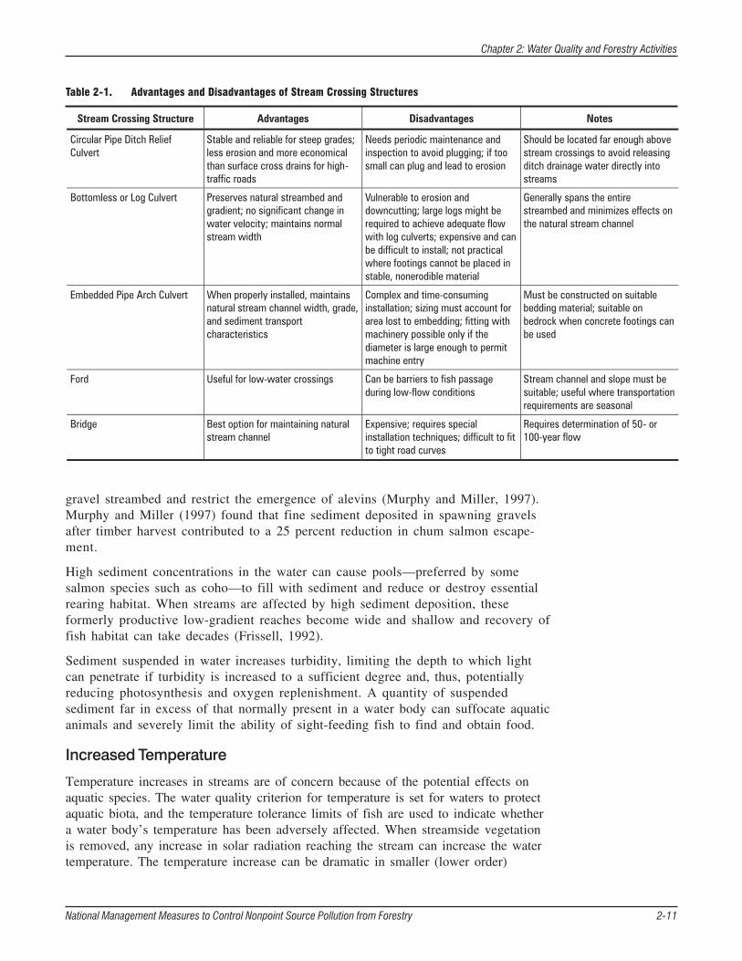
Forest road stream crossings can be sites of sedimentation and hydrologic change if an inappropriate type and size of crossing is installed. A culvert that is too small will not permit the passage of debris and water during flood events, and can lead to instream erosion and culvert blowout. A culvert, ford, or bridge that is improperly installed can cause erosion at the site of the crossing. Problems associated with stream crossings can be avoided by proper planning (Wiest, 1998). Crossings can be located where gradient or channel alignment are relatively uniform and selected to be large enough for floodwaters and instream debris to pass through. The advantages and disadvantages of various stream crossing structures are summarized in Table 2-1. Management measures and BMPs for preventing problems at stream crossings associated with forestry activities are discussed in Chapter 3, sections C, Road Construction/Reconstruction, and D, Road Management.
An excessive quantity of sediment in a water body can cause or lead to a variety of problems. Sediment can reduce a water body’s ability to support aquatic life when it fills the spaces between rocks and grains of sand where many organisms live, forage, and spawn, hindering these activities. Fine sediments, of the size that can be deposited between grains of sand, are most threatening to fish. If deposited on fish eggs, fine sediments can reduce egg-to-fry survival and fry quality by suffocating eggs and forming a physical barrier to emerging larvae. Different species have different tolerances to fine sediment due to the fry having different head diameters. Coarse sediment can cap a
National Management Measures to Control Nonpoint Source Pollution from Forestry 2-10
National Management Measures to Control Nonpoint Source Pollution from Forestry 2-11
Chapter 2: Water Quality and Forestry Activities
gravel streambed and restrict the emergence of alevins (Murphy and Miller, 1997).Murphy and Miller (1997) found that fine sediment deposited in spawning gravelsafter timber harvest contributed to a 25 percent reduction in chum salmon escape-ment.
High sediment concentrations in the water can cause pools—preferred by somesalmon species such as coho—to fill with sediment and reduce or destroy essentialrearing habitat. When streams are affected by high sediment deposition, theseformerly productive low-gradient reaches become wide and shallow and recovery offish habitat can take decades (Frissell, 1992).
Sediment suspended in water increases turbidity, limiting the depth to which lightcan penetrate if turbidity is increased to a sufficient degree and, thus, potentiallyreducing photosynthesis and oxygen replenishment. A quantity of suspendedsediment far in excess of that normally present in a water body can suffocate aquaticanimals and severely limit the ability of sight-feeding fish to find and obtain food.
Increased Temperature
Temperature increases in streams are of concern because of the potential effects onaquatic species. The water quality criterion for temperature is set for waters to protectaquatic biota, and the temperature tolerance limits of fish are used to indicate whethera water body’s temperature has been adversely affected. When streamside vegetationis removed, any increase in solar radiation reaching the stream can increase the watertemperature. The temperature increase can be dramatic in smaller (lower order)
Table 2-1. Advantages and Disadvantages of Stream Crossing Structures
Chapter 2: Water Quality and Forestry Activities
streams and can heat the water to beyond the tolerance limits of some aquatic species. Increased water temperatures can also accelerate the chemical processes that occur in the water, decrease the ability of a water body to hold oxygen, and lower the concentration of dissolved oxygen.
Because streams in forests are shaded, fish species in forested streams tend to be cooler-water species, such as salmon and trout, than fish species in non-forested streams. The duration of an elevated temperature and the availability of cool pools of water are among the factors that determine how severe an effect a temperature increase has on fish and other biota. An elevated water temperature can retard growth, reduce reproductive success, increase susceptibility to disease, decrease the ability to avoid predators, and decrease the ability to compete for food (Spence et al., 1996).
Riparian forested buffers, as discussed above and in Chapter 3, section B (Streamside Management Areas) are a primary means of minimizing temperature increases due to timber harvesting. The role of riparian forested buffers in regulating ambient stream temperature, however, varies with stream width and vegetation type, as well as other factors such as stream depth, orientation to the sun, and surrounding topography. A narrow stream with a complete riparian forested buffer might receive as little as 1 to 3 percent of the total incoming solar radiation, whereas a wide mid-order stream might receive as much as 10 to 25 percent. Riparian vegetation, therefore, has less ability to regulate water temperature as stream width increases (Spence et al., 1996).
Nutrients
Nutrients, such as nitrogen and phosphorus from fertilizers, soil, and plant material, are primary chemical water quality constituents. They can enter water bodies attached to sediments, dissolved in the water, or transported by air. Forest harvesting can increase nutrient leaching from the soil, though the effect generally subsides to near precutting levels within two years of a harvest. Low to moderate increases in nutrient levels may have no or a beneficial effect on an aquatic environment, but excessive amounts of nutrients can stimulate algal blooms or an overgrowth of other types of aquatic vegetation. This can in turn lead to an increase in the amount of decomposing plant material in an aquatic system and, in turn, increased turbidity and biological oxygen demand. The latter effect can decrease dissolved oxygen concentrations, with potentially detrimental effects to aquatic biota. Chapter 3, section I, Forest Chemical Management, discusses methods for minimizing the adverse effects of forestry activities on nutrient balances.
Organic debris, discussed below, can be an important source of nutrients in an aquatic environment, and SMAs play an important role in organic debris inputs and maintaining nutrient balances in aquatic forest ecosystems.
Organic Debris
Organic debris—primarily composed of leaves, twigs, branches, and fallen trees—is an important element of water quality in that it provides nutrients and stream structure that are important to supporting aquatic life. It ranges in size from suspended organic matter in water to fallen trees. Large woody debris, or LWD, can be whole trees or tree limbs that have fallen into streams. It creates the physical habitat diversity essential to support-
National Management Measures to Control Nonpoint Source Pollution from Forestry 2-12
Chapter 2: Water Quality and Forestry Activities
ing aquatic life. As a structural element, it influences the movement and storage of sediment and gravel in streams and stabilizes streambeds and banks (Spence et al., 1996). Small organic litter—primarily leaves in deciduous forests and cones and needles in coniferous forests—is an important source of nutrients for aquatic communities. It usually decomposes over a year or more, depending on forest type.
When streamside vegetation is removed, inputs of organic debris decrease and the amount of sunlight reaching the water increases. A stream that might previously have relied primarily on sources of nutrients external to the stream (fallen debris) can be forced to rely primarily on instream sources (such as algal growth and instream vegetation). The latter may not be present in high-order streams.
Organic debris generated during forestry activities includes residual logs, slash, litter, and soil organic matter. These materials can perform some of the same positive functions as naturally occurring LWD and organic litter. If their abundance in a stream is substantially greater than normal, however, they can also block or redirect streamflow, alter nutrient balances, and decrease the concentration of dissolved oxygen as they decompose and consume oxygen. Observing management guidelines for streamside management areas, discussed in Chapter 3, section B, Streamside Management Areas, is a key means to minimize ecological and water quality effects due to organic debris.
Forest Chemicals
Chemicals that enter surface waters can be toxic to aquatic biota, make it difficult to attain drinking water quality criteria, and degrade the aesthetics of streams. The most harmful substances considered under the general category of “forest chemicals” and used during forestry operations are fuel, oil, and lubricants; coolants; and others used for harvesting and road-building equipment. Simple precautions can prevent water quality deterioration, whereas improper use and management of chemicals used during forestry operations can result in degraded water quality.
Fertilizers, herbicides, and pesticides are used to prepare a site for regeneration and to protect forests from disease and pests. Adverse effects on water quality due to forest chemical applications typically result from not following the specific application instructions for the chemical being used, such as specifications for the quantity to apply and the distance to maintain around watercourses (Norris and Moore, 1971). Generally, the water quality and aquatic biota threats due to fertilizers, herbicides, and pesticides are small because the chemicals are applied at most only one to three times at a harvest site and they specifically target biochemical pathways present only in plants, rendering them of little danger to aquatic animals. Furthermore, the half-lives of forestry herbicides are on the order of less than 100 days, so bioaccumulation in aquatic species is rarely of concern. Precautions for minimizing water quality effects due to forest chemical use are discussed in Chapter 3, section I, Forest Chemical Management.
Hydrologic Modifications
Streamflow is a concern because of the instream changes that can occur if the quantity of streamflow or the timing of streamflow is changed substantially as a result of a forest harvest or repeated forest harvesting. The dynamics of forest harvesting and streamflow response are discussed above under Forested Watershed Hydrology. Methods of minimizing the streamflow effects of forest roads and timber
National Management Measures to Control Nonpoint Source Pollution from Forestry 2-13
Chapter 2: Water Quality and Forestry Activities
harvesting are discussed in Chapter 3, and particularly in sections C, Road Construction/Reconstruction, D, Road Management, and E, Timber Harvesting.
If forest roads or timber harvesting result in a more rapid delivery of runoff to streams than before roads were present or timber was harvested, peak flows can be increased. This can lead to increases in channel scouring, streambank erosion, downstream sedimentation, and flooding. The magnitude of changes in peak flows after logging depends on the size of the watershed and the amount of land harvested, and to a lesser extent on road building. Changes are usually greatest in small watersheds and where a large percentage of the surrounding watershed is logged at one time. Streamflow can be increased as a result of forest road building alone, but this usually occurs only in small, upland watersheds where streams and streamflow are small and the amount of impervious or heavily compacted surface from the harvest and associated activities is large in proportion to the areal extent of the watershed. Downstream flooding is rarely a consequence of logging in small, upstream watersheds (Adams and Ringer, 1994).
Normally, when only a small portion (e.g., less than 15 percent) of a watershed is harvested, flow is not altered in associated streams. Where more than 15 to 20 percent of the forest canopy is removed, streamflow typically increases. Any increase is greatest in the first years after harvest and typically becomes smaller with time as vegetation grows on harvested sites. Streamflow generally returns to the original level within 20 to 60 years, depending on forest and land type (Adams and Ringer, 1994).
Physical Barriers
Forest road stream crossings can be sites of hydrologic change, sedimentation, and debris buildup if the appropriate type and size of crossing are not selected. Improperly installed culverts at stream crossings can lead to erosion around the culvert and of the road surface when the design storm is exceeded or if debris inhibits or redirects flow. This can result in excessive sedimentation and channel alterations downstream. Culverts installed above the grade of a stream can create a barrier to upstream fish migration. Any of the following conditions associated with culverts can block fish passage: water velocity at the culvert is too fast, water depth at the culvert is too shallow, there is no resting pool below the culvert, the culvert is too high for a fish to jump, or the culvert is clogged because of lack of maintenance.
Problems associated with stream crossings can be avoided by proper planning (Wiest, 1998). Crossings can be located where they do not cause large increases in water velocity and there are not large changes in gradient or channel alignment. Doing so can minimize effects on sedimentation and fish passage. Planning for safe fish passage involves determining the type and extent of fish habitat, the species of fish present in the stream, and the window during which instream work can occur without harming fish habitat or interfering with fish migration. Adequate fish passage is that which conserves the free movement of fish in and about streams, lakes, and rivers in order that they can complete critical phases of their life cycles. It permits adult fish to migrate to spawning areas and juvenile fish to accompany adult fish or make local moves to rearing or overwintering areas. The advantages and disadvantages of various stream crossing structures are summarized in Table 2-1.
National Management Measures to Control Nonpoint Source Pollution from Forestry 2-14
Chapter 2: Water Quality and Forestry Activities
Fords, bridges, and culverts of various sizes, shapes, and materials can be installed to avoid hydrologic and habitat changes and to provide adequate fish passage. Road crossings and culverts also need to be installed to fail when the design storm is exceeded to prevent substantial sedimentation. Management measures and BMPs for preventing physical barriers in streams associated with forestry activities are discussed in Chapter 3, sections C, Road Construction/Reconstruction, and D, Road Management.
Cumulative Effects
Cumulative effects occur when two or more activities cause the same response within a watershed (e.g., lead to increased stream flow at a given time of year), when multiple responses disturb the same resource (e.g., increased stream flow and sediment yield both affect the same stream reach), when one response provokes another (e.g., increased stream flow induces scouring around culverts), or when responses interact to produce another (e.g., road construction on a steep slope and unusually heavy rains produce a mass soil movement) (Reid, 1993). Cumulative effects can occur spatially, when numerous activities conducted at different locations within a watershed contribute to instream responses, or temporally, when a single activity repeated in the same place or different activities conducted in different places at different times have an additive effect. Most land use activities affect only one of four environmental parameters—vegetation, soils, topography, or chemicals—and other watershed changes result from initial effects on these factors. If a change in vegetation or another one of these four factors is persistent or affects watershed transport processes or rates, cumulative effects can result.
Cumulative effects are of concern with respect to forest roads; forest road construction, use, and maintenance; and forest harvesting because the changes that can occur in watershed processes following these activities can persist for many years. This persistence increases the potential for cumulative effects to occur. Examples of potential persistent effects due to forestry activities include the delivery of sediment to streams from a forest road used repeatedly over a period of years and increased subsurface flow and decreased evapotranspiration due to a reduced amount of vegetation at a harvest site.
Forest roads and timber harvesting can cause changes to a landscape or stream on a temporal scale far different from that associated with the life of the road or duration of the harvest. A road may be constructed and used for many years, and its effect on a landscape can continue for years after it is no longer needed. Cafferata and Spittler (1998) found that “legacy” roads can be significant sources of sediment for decades after their construction. Reid (1998) also found that sedimentation rates may increase 25 years or more after logging roads are abandoned as they begin to fail and erode. A harvest might occur in one season, or numerous harvests in a watershed might occur over a number of years, and during the months or years afterward temporary roads and stream crossings might be removed and the ground or streambeds rehabilitated. In contrast, recovery of a forest, instream recovery from channel erosion, habitat recovery, and aquatic community recovery occur on time scales much longer than the harvest. The long-term recovery times provide ample opportunity for other disturbances to contribute to cumulative effects.
National Management Measures to Control Nonpoint Source Pollution from Forestry 2-15
Chapter 2: Water Quality and Forestry Activities
Consider the following study of cumulative effects, modeled using Monte Carlo simulations of four hypothetical watersheds (Ziemer et al., 1991). Each watershed was a 10,000-ha, fifth-order watershed typical of one that might be located in coastal Oregon or California at 300 to 500 meters of elevation and 30 kilometers inland from the coast. Annual rainfall was simulated at 1500 millimeters. The four watersheds were simulated to have the following treatments:
• One watershed was simulated as undisturbed.
• One watershed was simulated as clear-cut and roaded within 10 years of the commencement of harvesting, with harvesting beginning at the upper reaches of the watershed and progressing toward the mouth.
• One watershed was simulated as harvested at the rate of 1 percent per year, beginning at the mouth and progressing upstream.
• The fourth watershed was again simulated as harvested at a rate of 1 percent peryear, but with the harvests widely dispersed throughout the watershed.
These harvesting patterns were simulated as being repeated each 100 years, and in each watershed (except the unharvested one) one-third of the road network was simulated to be rebuilt each 100 years. The greatest differences between the treatments were noticed in the first 100 years, and they related most to the rate of treatment. That is, to whether the harvests were concentrated or dispersed temporally. By the second 100 years, the primary difference between the treatments was in the timing of the impacts. Interestingly, the simulation indicated that temporally dispersing the harvest units did not reduce cumulative effects.
The conclusion reached by the authors was that current estimates of cumulative effects due to logging underestimate the effects because they accumulate over much longer periods than previously thought, but they overestimate the benefits of temporally dispersing harvests in a watershed. Concentrating the treatments (over 10 years instead of 100 years) increased the chances of cumulative effects on the affected resources.
A more detailed discussion of issues related to cumulative effect assessment is provided in Chapter 4, Using Management Measures to Prevent and Solve Nonpoint Source Pollution Problems in Watersheds.
Mechanisms to Control Forestry Nonpoint Source Pollution
Nonpoint source pollution control practices for forestry activities are referred to as best management practices (BMPs), management practices, accepted forestry practices, management measures, BMP systems, management practice systems, and the like. Some of these terms have specific uses in legislation and regulations, whereas other terms are found in technical manuals, journal articles, and informational materials. Forestry management practices have been developed by all states, though they may not exist as a separate program or set of rules or guidelines. In some states, forest protection guidelines are contained within watershed protection or water quality protection programs, in some they are incorporated into erosion and sedimentation control programs, while in others a separate program of forestry rules or guidelines governs harvesting activities. Links to all
National Management Measures to Control Nonpoint Source Pollution from Forestry 2-16
Chapter 2: Water Quality and Forestry Activities
state forestry programs, with information on the agencies that are involved in protecting forests in the states, can be found at the Web site www.usabmp.net.
BMPs are individual practices (such as leaving a streamside management area) that serve specific functions (such as protecting streams from temperature increases and filtering sediment and nutrients from runoff). Management measures, as the term is used in this guidance, are environmental goals to be attained by using one or more BMPs. For instance, minimizing sediment delivery to streams (part of the overall goal of the Management Measure for Streamside Management Areas [see Chapter 3, section B]) from harvest sites might be accomplished with the following BMPs: maintaining a riparian buffer; locating roads, yarding areas, and skid trails away from streams; and not using machinery in streams.
BMPs are the building blocks for BMP systems and management measures, and the implementation of the forestry management measures in this guidance, as appropriate to the situation, can result in comprehensive water quality protection for most harvesting operations.
Management Measures
The management measures in this guidance contain technology-based performance expectations and, in many cases, specific actions to be taken to prevent or minimize nonpoint source pollution. Management measures are means to control the entry of pollutants into surface waters. Management measures achieve nonpoint source pollutant control goals through the application of nonpoint pollution control BMPs, which may be technologies, processes, siting criteria, operating methods, or other alternatives. Chapter 3 contains the management measures and recommended BMPs controlling nonpoint source pollution from forestry activities.
For example, the Management Measure for Site Preparation and Forest Regeneration (see section F) contains the performance expectation Confine on-site potential nonpoint source pollution and erosion resulting from site preparation and the regeneration of forest stands. Statements of BMPs or actions that can be taken to achieve this performance expectation (e.g., Conduct mechanical tree planting and ground-disturbing site preparation activities on the contour of sloping terrain) are generally included in the management measure statement. Even so, in most cases there is considerable flexibility to determine how to best achieve the performance expectations for the management measures. EPA’s management measures for forestry and BMPs recommended to be used to achieve them are described in Chapter 3.
Best Management Practices
BMPs can be structural (e.g., culverts, broad-based dips, windrows) or managerial (e.g., preharvest planning, forest chemical management, fire management). Both types are used to control the delivery of nonpoint source pollutants to receiving waters in one of three ways:
• They minimize the quantity of pollutants released (pollution prevention).
• They retard the transport or delivery of pollutants, either by reducing the amount of water (and thus the amount of the pollutant) transported or by improving deposition of the pollutant (delivery reduction).
National Management Measures to Control Nonpoint Source Pollution from Forestry 2-17
Chapter 2: Water Quality and Forestry Activities
• They render the pollutant harmless or less harmful before or after it is delivered to a water body through chemical or biological transformation.
BMPs are usually designed to control a particular type of pollutant from a specific land use or activity. For example, stream crossings are specified and designed to control erosion from stream banks where roads cross them and sediment delivery from roads to streams. BMPs might also provide secondary benefits. Streamside management areas, for instance, reduce sediment delivery to streams and protect streams from temperature increases, and they also provide a source of large organic debris to streams and habitat for wildlife.
Sometimes, however, a BMP might increase the generation, transport, or delivery of a pollutant and is best used in combination with other BMPs. Site preparation, for example, is generally performed for commercial timber regeneration, but can temporarily expose soil to erosive forces. Therefore, sedimentation control BMPs, such as establishing SMAs of widths suitable to retain the anticipated quantity of eroded soil and not conducting mechanical site preparation on steep slopes, are recommended to be combined with site preparation techniques.
Which BMP is best for in a given situation depends on many factors. Criteria for determining which BMP is best for a particular forestry activity might include the harvesting technique, frequency of road use, topography, soil type, climate, amount of maintenance feasible BMPs will require, the willingness of landowners to implement BMPs (in a program of voluntary implementation, for instance), and BMP cost and cost-effectiveness. The relative importance assigned to these and other criteria in judging what is best varies among states, within states, and among landowners, often for very good reasons. For example, erosion control considerations are very different in mountainous western regions versus relatively flat southeastern coastal plain regions. Some BMPs that can be used to achieve the forestry management measures are described in Chapter 3.
Best Management Practice Systems
The distinction between BMPs selected for particular areas or aspects (e.g., roads, yarding areas, skid trails, stream crossings) of a harvest activity and a BMP system is similar to the difference between controlling pollutant sources individually and controlling them based on a TMDL. Pollutant sources, especially point sources, controlled on an individual basis are analyzed independently relative to a standard for a type of industry and water quality criteria for the receiving water body. A TMDL incorporates all pollutant sources affecting a water body and limits loads for individual sources relative to the assimilative capacity of the water body. Similarly, BMPs selected for individual aspects of a harvest activity views those activities or areas independently of other activities and areas to control water pollution, while approaching water quality considerations from the point of view of a BMP system would involve considering the harvest and all of its activities and affected areas from a hydrologic perspective, examining the flow of surface water and groundwater over the entire site, and determining the best locations for sediment, nutrient, and other pollutant interception. As an example, consider a harvest operation that involves road repairs, a stream crossing, creation of a yarding area, and site preparation. Individual BMPs can be selected for each aspect of the harvest operation. That is, BMPs for sediment retention (for example) could be chosen for the road segment, others selected for the stream crossing, and still others placed on the yarding area.
National Management Measures to Control Nonpoint Source Pollution from Forestry 2-18
Chapter 2: Water Quality and Forestry Activities
Each set of BMPs for these separate areas would be selected to control sediment runoff from that area alone. Alternatively, the spatial relationship of the three areas from a water flow or hydrologic perspective could be considered to understand how BMPs selected for the site preparation work might be altered somewhat to capture sediment from the yarding area, thus eliminating the need for separate BMPs for the yarding area. Also, it might be noticed that a different type or orientation of BMPs along the road segment could significantly reduce the potential for sediment delivery along the road to the stream crossing, thus permitting a change in the stream crossing to better ensure retaining the natural stream shape. The BMP system approach might reduce the total number of BMPs required and increase the efficiency of the BMPs for protecting water quality, and thus reduce the cost of the operation.
Structural and managerial BMPs used as part of a BMP system can be selected, designed, implemented, and maintained in accordance with site-specific considerations (e.g., slope, soil type, proximity to streams, and layout of the harvest) so they work effectively together. Planning BMP use as part of a system also helps to ensure that design standards and specifications for the individual BMPs are compatible so they will achieve the greatest amount nonpoint source pollution control possible with the least cost.
Cost Estimates for Forest Practice Implementation
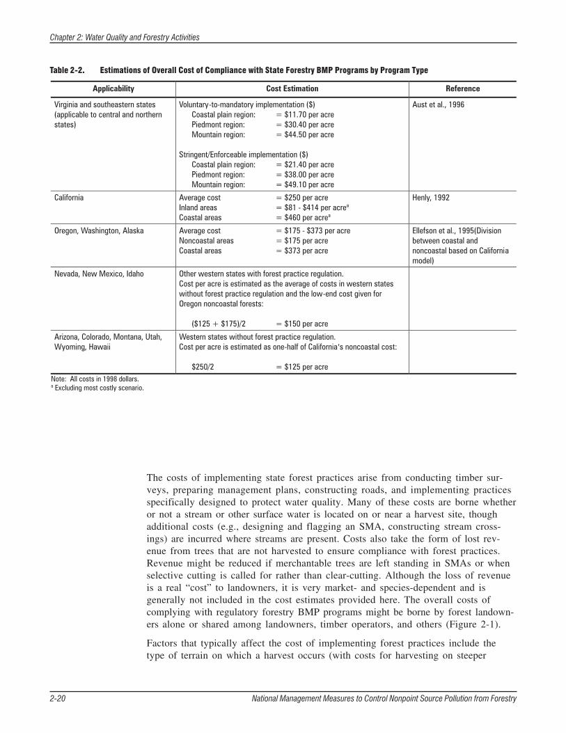
Estimates of the per acre cost of implementing BMPs for timber harvests were arrived at based on information obtained from published reports on regional studies of the cost of BMP implementation and cost estimates based on the regulatory structure of forestry practice programs. Studies have been conducted on the cost of implementing forestry practices for water quality and soil protection in the Southeast and some western states (Aust et al., 1996; Dissmeyer and Foster, 1987; Dubois et al., 1991; Henly, 1992; Lickwar, 1989; Olsen et al., 1987). Costs associated with complying with forest practices in states where their implementation is either voluntary or regulated, with differing numbers and types of requirements depending on the state, have also been estimated (Table 2-2) (Ellefson et al., 1995).
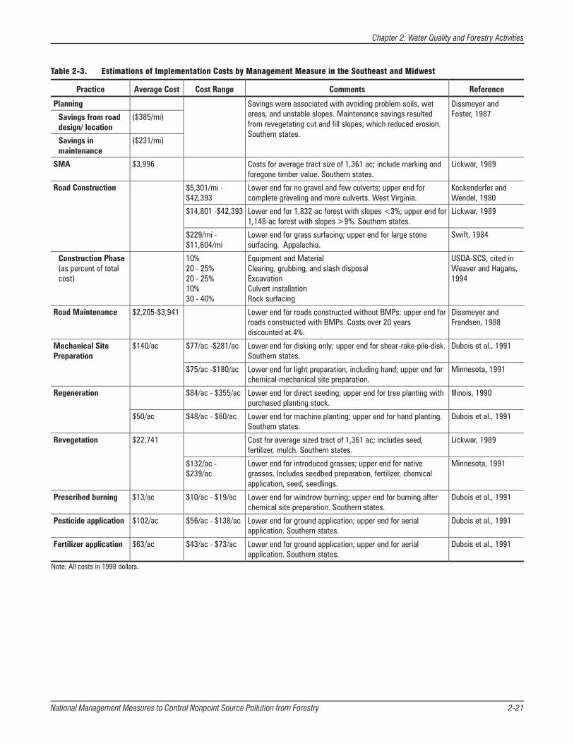
Some cost information for forest practice implementation is based on the average increased cost of conducting a harvest when management measures, i.e., a suite of practices, are used versus when they are not used (Table 2-3). Costs provided in this way emphasize the difficulty in separating the costs of implementing individual forest practices. This difficulty is due to incorporating the cost of using numerous BMPs into the accomplishment of a single harvesting or road construction activity, and spreading the cost for individual practices across the accomplishment of multiple activities. For example, the cost of adhering to a state regulation for stream crossings might be spread among the costs of planning a harvest to minimize the number of stream crossings, designing and constructing forest roads to accommodate the plan and minimize instream effect to water quality and fish, and the actual construction of the stream crossings. Furthermore, these costs differ with each harvest because the terrain, soils, location of harvest site relative to streams, and hydrology are different at each harvest site. Therefore, all costs presented here are best regarded as rough estimates.
National Management Measures to Control Nonpoint Source Pollution from Forestry 2-19
2-20 National Management Measures to Control Nonpoint Source Pollution from Forestry
Chapter 2: Water Quality and Forestry Activities
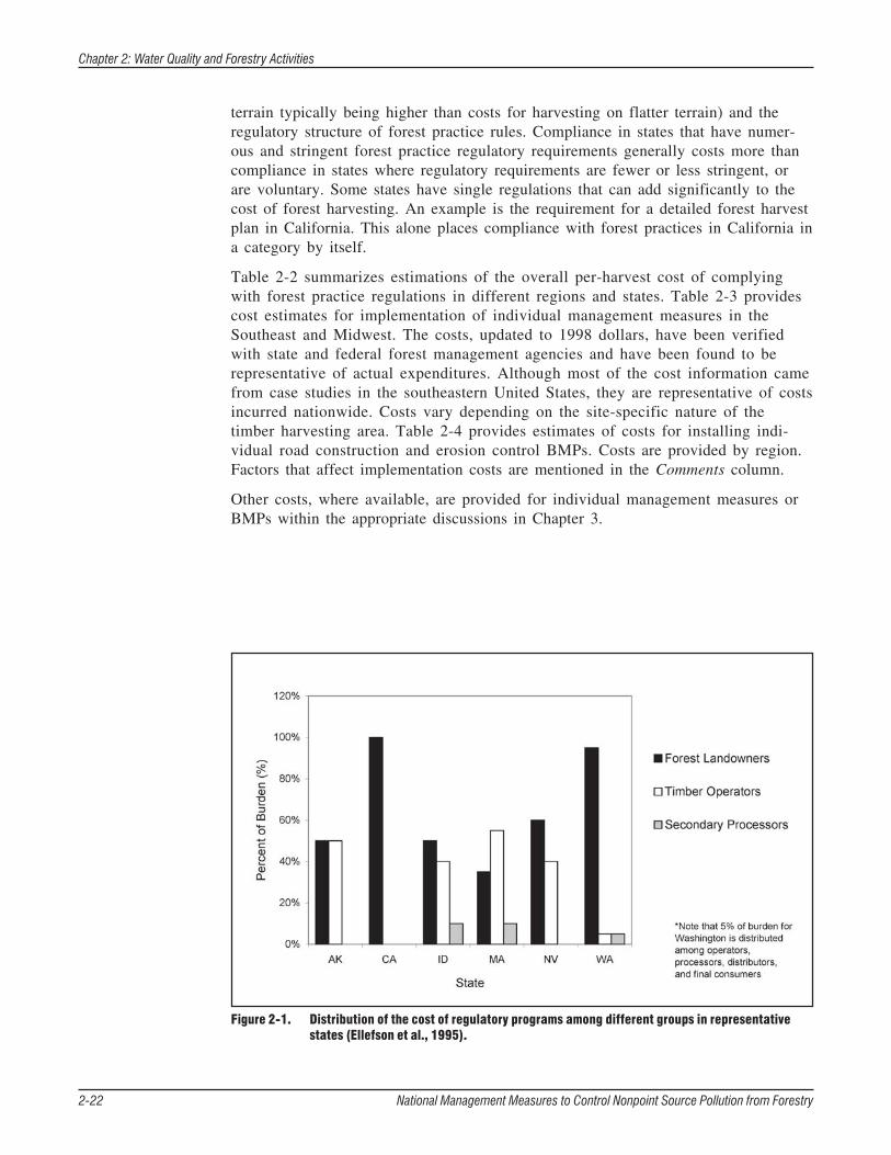
The costs of implementing state forest practices arise from conducting timber sur-veys, preparing management plans, constructing roads, and implementing practicesspecifically designed to protect water quality. Many of these costs are borne whetheror not a stream or other surface water is located on or near a harvest site, thoughadditional costs (e.g., designing and flagging an SMA, constructing stream cross-ings) are incurred where streams are present. Costs also take the form of lost rev-enue from trees that are not harvested to ensure compliance with forest practices.Revenue might be reduced if merchantable trees are left standing in SMAs or whenselective cutting is called for rather than clear-cutting. Although the loss of revenueis a real “cost” to landowners, it is very market- and species-dependent and isgenerally not included in the cost estimates provided here. The overall costs ofcomplying with regulatory forestry BMP programs might be borne by forest landown-ers alone or shared among landowners, timber operators, and others (Figure 2-1).
Factors that typically affect the cost of implementing forest practices include thetype of terrain on which a harvest occurs (with costs for harvesting on steeper
Table 2-2. Estimations of Overall Cost of Compliance with State Forestry BMP Programs by Program Type
National Management Measures to Control Nonpoint Source Pollution from Forestry 2-21
Chapter 2: Water Quality and Forestry Activities
Table 2-3. Estimations of Implementation Costs by Management Measure in the Southeast and Midwest
Chapter 2: Water Quality and Forestry Activities
terrain typically being higher than costs for harvesting on flatter terrain) and the regulatory structure of forest practice rules. Compliance in states that have numerous and stringent forest practice regulatory requirements generally costs more than compliance in states where regulatory requirements are fewer or less stringent, or are voluntary. Some states have single regulations that can add significantly to the cost of forest harvesting. An example is the requirement for a detailed forest harvest plan in California. This alone places compliance with forest practices in California in a category by itself.
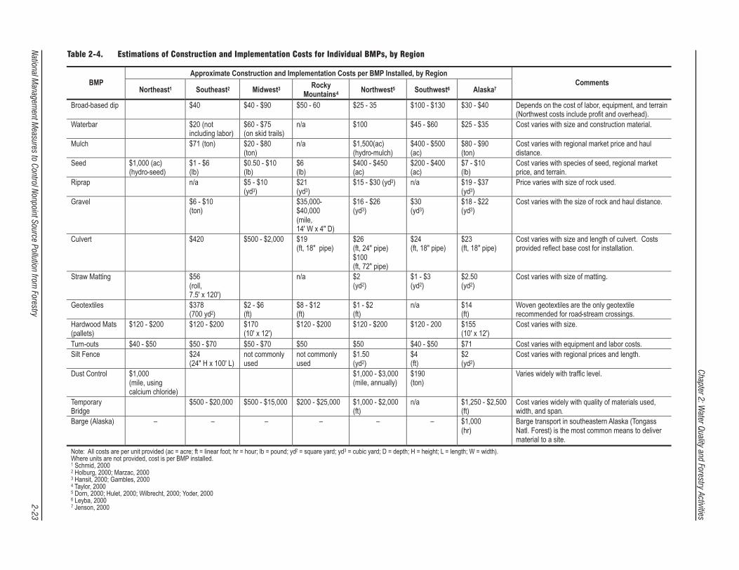
Table 2-2 summarizes estimations of the overall per-harvest cost of complying with forest practice regulations in different regions and states. Table 2-3 provides cost estimates for implementation of individual management measures in the Southeast and Midwest. The costs, updated to 1998 dollars, have been verified with state and federal forest management agencies and have been found to be representative of actual expenditures. Although most of the cost information came from case studies in the southeastern United States, they are representative of costs incurred nationwide. Costs vary depending on the site-specific nature of the timber harvesting area. Table 2-4 provides estimates of costs for installing individual road construction and erosion control BMPs. Costs are provided by region. Factors that affect implementation costs are mentioned in the Comments column.
Other costs, where available, are provided for individual management measures or BMPs within the appropriate discussions in Chapter 3.
Figure 2-1. Distribution of the cost of regulatory programs among different groups in representative states (Ellefson et al., 1995).
National Management Measures to Control Nonpoint Source Pollution from Forestry 2-22
Natio
nal Manag
ement M
easures to C
ontro
l Nonp
oint S
ource P
ollutio
n from
Forestry
2-2
3
Chap
ter 2: W
ater Quality and
Forestry A
ctivities
Table 2-4. Estimations of Construction and Implementation Costs for Individual BMPs, by Region

Chapter 2: Water Quality and Forestry Activities
National Management Measures to Control Nonpoint Source Pollution from Forestry 2-24