Causewayed enclosures and the Early Neolithic: the chronology
29
1 South East Research Framework resource assessment seminar Causewayed enclosures and the Early Neolithic: the chronology and character of monument building and settlement in Kent, Surrey and Sussex in the early to mid-4th millennium cal BC Frances Healy Honorary Research Fellow, Cardiff University Causewayed enclosures This paper is concerned with the early and middle 4th millennium cal BC, the period occupied by the early Neolithic. Its starting point lies in the project Dating Causewayed Enclosures: towards a History of the Early Neolithic in Southern Britain, initiated at Cardiff University in 2003 by Professor Alasdair Whittle, and funded by The Arts and Humanities Research Council and English Heritage, whose Scientific Dating Co-Ordinator, Dr Alex Bayliss, has been responsible for obtaining more than 400 new radiocarbon dates and modelling them with an equal number of others from 42 causewayed and related enclosures in England, Wales and Ireland (Whittle et al. 2008; Bayliss et al. forthcoming; Whittle et al. in prep.). These enclosures, characteristically defined by ditches interrupted by gaps (or causeways) have long been seen as defining features of the early Neolithic in southern Britain. This is largely due to their large size compared with other earthworks of the period, to their often rich cultural assemblages and to the stratified sequences which they provide. They consist of single or multiple circuits and other lengths of interrupted ditch, sometimes with surviving banks, and range in area from over 8 ha to less than 1 ha. They saw varied and sometimes rich deposits of human bone, food remains, digging implements, artefacts and the debris of their manufacture. The complexity of the sites, their contents, and the interpretations that they have prompted is summarised by, among others, Edmonds (1999, 80–108), J. Thomas (1999, 38–45) and Oswald et al. (2001). Their place in the 4th millennium cal BC remained, however, unclear. The questions formulated at the start of the project were thus the following, and sampling was designed to answer them: • When did causewayed enclosures begin to be built in Britain? • Did all of them begin to be built at the same time? • How quickly was each built? • Was it possible to see in detail, even at a generational timescale, how their use developed and changed through time? • To what extent was their use continuous and to what extent episodic? • Were they all used for the same length of time? • What would better dating of causewayed enclosures contribute to a firmer understanding of the initial development of the British Neolithic? The method employed has been the application of Bayesian statistical modeling to radiocarbon dates (Bronk Ramsey 1995; Buck et al. 1996; Bayliss and Bronk Ramsey 2004; Bayliss et al. 2007a). It is based on the principle that, although the calibrated age ranges of radiocarbon measurements accurately estimate the calendar ages of the samples themselves, it is the dates of archaeological events associated with those samples that are important. Bayesian techniques can provide realistic estimates of the dates of such events by combining absolute dating evidence, such as radiocarbon dates, with any and all other information about the samples and their contexts (prior information). This constrains the probability
Transcript of Causewayed enclosures and the Early Neolithic: the chronology

1
South East Research Framework resource assessment seminar Causewayed enclosures and the Early Neolithic: the chronology and
character of monument building and settlement in Kent, Surrey and Sussex
in the early to mid-4th millennium cal BC
Frances Healy
Honorary Research Fellow,
Cardiff University
Causewayed enclosures
This paper is concerned with the early and middle 4th millennium cal BC, the period occupied by the early Neolithic. Its starting point lies in the project Dating Causewayed Enclosures:
towards a History of the Early Neolithic in Southern Britain, initiated at Cardiff University in 2003 by Professor Alasdair Whittle, and funded by The Arts and Humanities Research Council and English Heritage, whose Scientific Dating Co-Ordinator, Dr Alex Bayliss, has been responsible for obtaining more than 400 new radiocarbon dates and modelling them with an equal number of others from 42 causewayed and related enclosures in England, Wales and Ireland (Whittle et al. 2008; Bayliss et al. forthcoming; Whittle et al. in prep.). These enclosures, characteristically defined by ditches interrupted by gaps (or causeways) have long been seen as defining features of the early Neolithic in southern Britain. This is largely due to their large size compared with other earthworks of the period, to their often rich cultural assemblages and to the stratified sequences which they provide. They consist of single or multiple circuits and other lengths of interrupted ditch, sometimes with surviving banks, and range in area from over 8 ha to less than 1 ha. They saw varied and sometimes rich deposits of human bone, food remains, digging implements, artefacts and the debris of their manufacture. The complexity of the sites, their contents, and the interpretations that they have prompted is summarised by, among others, Edmonds (1999, 80–108), J. Thomas (1999, 38–45) and Oswald et al. (2001). Their place in the 4th millennium cal BC remained, however, unclear. The questions formulated at the start of the project were thus the following, and sampling was designed to answer them:
• When did causewayed enclosures begin to be built in Britain?
• Did all of them begin to be built at the same time?
• How quickly was each built?
• Was it possible to see in detail, even at a generational timescale, how their use developed and changed through time?
• To what extent was their use continuous and to what extent episodic?
• Were they all used for the same length of time?
• What would better dating of causewayed enclosures contribute to a firmer understanding of the initial development of the British Neolithic?
The method employed has been the application of Bayesian statistical modeling to radiocarbon dates (Bronk Ramsey 1995; Buck et al. 1996; Bayliss and Bronk Ramsey 2004; Bayliss et al. 2007a). It is based on the principle that, although the calibrated age ranges of radiocarbon measurements accurately estimate the calendar ages of the samples themselves, it is the dates of archaeological events associated with those samples that are important. Bayesian techniques can provide realistic estimates of the dates of such events by combining absolute dating evidence, such as radiocarbon dates, with any and all other information about the samples and their contexts (prior information). This constrains the probability
2
distributions of individual measurements and provides a means of estimating the dates of events not themselves directly dated but nonetheless located in a sequence of dated events. An obvious example is the construction date of a particular monument. The resulting ‘posterior density estimates’ are not absolute. They are interpretative, and will change as additional data become available or as the existing data are modeled from different perspectives. In practice, especially in prehistory, the most commonly employed prior information consists of stratigraphic relationships: if sample B was stratified above sample A, and both were contemporary with their contexts, then B must be later than A and a part of each probability distribution can be eliminated. The second most commonly employed prior information is the assumption that the events concerned occurred uniformly, although not necessarily continuously, within a bounded phase. This is applied to counteract the scatter derived from the errors attached to radiocarbon dates, an effect of which is that, within any group of dates relating to a period of activity, a proportion of the probability distributions will fall earlier or later than its actual span, making it appear to start earlier and finish later than it actually did (Steier and Rom 2000; Bronk Ramsey 2000). Simple calibrated date ranges (95% confidence intervals) were calculated by the maximum intercept method (Stuiver and Reimer 1986). Calibrations and modeling were undertaken using the program OxCal v3.10 (Bronk Ramsey 1995; 1998; 2001) and the INTCAL04 dataset (Reimer et al. 2004). The worth of the method depends on the contemporaneity of sample and context, and hence on rigorous sample selection. Optimal samples are bones found in articulation, in other words still connected by soft tissue when buried and hence not long dead, followed by articulating bones found in proximity to each other, and hence probably not long out of articulation when buried or simply not recognised as articulated at the time of excavation. Also preferred are antler implements from the bases of ditches which they had probably been used to dig. If these sample types are not available, recourse can be made to single charred grains or nuts or single fragments of charcoal from short-lived sources from coherent deposits like hearths of dumps of charred material. The use of single fragments eliminates the risk of combining material of different ages in the same sample, and the dating of more than one sample from the same context makes it possible to check against the inclusion of stray fragments of older material (Ashmore 1999). Superficial carbonised residues from the interior surfaces of well preserved pottery sherds, ideally from well-represented pots, can also be used. Internal residues would have derived from food, and hence from recently dead animals or plants; but external residues are excluded because they might have derived from sooting which could have included carbon from already old timber or from peat used as fuel. The emphasis on fresh condition and substantial representation aims to ensure that only a short interval elapsed between breakage (i.e. final use including the formation of the residue) and burial. Where possible, two or three rounds of samples should be submitted from the same site, so that the results of one round can inform the selection of samples for the next. Pre-existing dates from the enclosures and other contexts have been retrospectively assessed by the same criteria as potential samples and modeled accordingly. In many cases they can serve only as termini post quos for their contexts because they were measured on bulk samples of charcoal or animal bone, which may have included material of various ages and/or because they were measured on samples, such as mature oak charcoal, which was clearly already old when buried. The 15 known or probable causewayed enclosures in the south-east are listed in Table 1. They are scattered through the north of the region in the Thames valley, Sheppey, the North Downs and Thanet. On the South Downs there are distinct eastern and western clusters. Most are on the Chalk, the exceptions being Staines on the Thames gravels and the two Kingsborough enclosures on Drift deposits. Excavation on various scales has taken place at twelve sites

3
(Table 1). Most have more than one circuit, and there are two cases of enclosures very close to each other. The two Kingsborough sites were within 200 m of each other, and it is possible that Chalk Hill may have had counterparts to the east and north. A length of interrupted ditch containing early Neolithic pottery has recently been excavated by the Trust for Thanet Archaeology to the east of the known enclosure (Lis Dyson pers. comm.), In addition, a ‘pit’ found during drain-digging in 1949 some 500 m to the north, on what was then a new housing estate, may have been an enclosure segment (on the basis of its size, shape and contents). It was roughly 3.0 m long, 1.20 m wide and 1.70 m deep; an articulated, contracted skeleton, probably male, lay near the base overlain by sherds of a decorated Bowl. At a higher level the disarticulated bones of another individual, possibly a young adult, were separated from the first by a fill which contained charcoal, an oyster shell and flint flakes (Dunning 1966, 8–11; Perkins 2004, 80). In the course of the project, a total of 81 radiocarbon dates was obtained from Staines, Kingsborough 1, Kingsborough 2, Chalk Hill, Offham Hill, Whitehawk, Bury Hill, Court Hill and The Trundle and modelled with 15 pre-existing dates from Kingsborough 1, Kingsborough 2, Offham Hill, Whitehawk, Bury Hill, Court Hill, The Trundle and Combe Hill. No suitable new samples could be found from Combe Hill or Halnaker Hill (the finds from the latter could not be located) and no suitable samples at all from Barkhale. Combe Hill was built before 3640–3010 cal BC, the date of a bulk charcoal sample from a ‘hearth’ containing Ebbsfleet Ware, animal bone, struck flint, and 2 sandstone rubbers (4590±100 BP; I-11613; Drewett 1994, 18). This feature looks like the fill of a recut into the primary silts (Musson 1950, fig. 2). Since all the charcoal from it was identified as of short-lived or relatively short-lived taxa (hazel, hawthorn and ash; Maby 1950), the deposit probably lies somewhere within the broad span of the date. The only date from Halnaker Hill remains that of 1310–810 cal BC, measured on a bulk sample of animal bone (2850±90 BP; I-12322; Bedwin 1992, 7). The form of the earthwork and the character of the finds from it support Bedwin’s conclusion (1992, 11) that the enclosure is indeed an early Neolithic one. The same conclusion holds for Barkhale. The two enclosures with substantial series of dates are Chalk Hill (Bayliss et al. forthcoming) and Whitehawk, and it is here that the exercise has been most successful, with heightened precision reflecting the number of reliable measurements available. It should be borne in mind, however, that almost all the Whitehawk samples were recorded by spit rather than layer, so that some stratigraphic guesswork was entailed. A dearth of suitable samples from other sites can to some extent be attributed to small-scale excavation or selective retention of animal bone (e.g. at The Trundle), unfavourable burial environments (e.g. the low to zero bone preservation at Kingsborough on Drift deposits), or poor bone collagen preservation (e.g. at Staines on the Thames gravels). The strongest contributing factor, however, is the behaviour of the populations who built and used the monuments. The diversity of depositional practice between circuits and between parts of the same circuit teased out by Philippa Bradley at Staines (2004) is, for example, replicated at Chalk Hill, where the combination of repeated recuts and the recurrent deposition of articulated animal bone in the outer ditch made it possible to obtain a sequence of measurements, while the other ditches yielded only one further sample between them. Comparable differences exist between enclosures. Offham Hill stands out for the ‘industrial’ character of its lithics, the only abundant finds category (James 1977). This was one of several enclosures where the ditches seem to have been left to silt up naturally after construction and initial use, often with very little deposition of cultural material. A case in point is Combe Hill, where Veronica Seton Williams excavated some 15 m of the inner ditch
4
and some 2 m of the outer, showing that Musson’s Ebbsfleet Ware recut in the west of the circuit was localized. She found no Neolithic pottery at all, and only a few hundred pieces of struck flint, which were concentrated in the entrance area rather than in the ditch (Drewett 1994, 17). The only remarkable find was a group of three partly ground flint axeheads placed side-by-side in the middle fill of an inner ditch segment to the south of the entrance (Drewett 1994, 15, figs.11, 12). There was virtually no bone, although the fills consisted overwhelmingly of chalk rubble in which bone would have been excellently preserved. There is little mention of bone in Seton Williams’ notebooks, and only eight animal bone small finds in her finds book (held in Eastbourne Museum). The scarcity looks like an original one. There are other enclosures where stratigraphy and finds suggest a brief and simple initial history, although several saw sporadic reuse in subsequent millennia. They include Kingsborough 2 (Allen and Leivers forthcoming), Barkhale (Leach 1983), Bury Hill (Bedwin 1981), Court Hill (Bedwin 1984) and Halnaker Hill (Bedwin 1992). It is difficult to date the duration of their early Neolithic use, because, few as suitable samples from primary contexts may be, those from subsequent ones are fewer or non-existent. The remaining enclosures had more complex histories and sequences. Staines counts among these, since it saw some recutting and the fills yielded large assemblages of early Neolithic material from bottom to top (Robertson-Mackay 1987, 30, 34–38). When it comes to construction dates, Chalk Hill was the earliest in the north of the region, with its first circuit built in the late 38th to early 37th century cal BC. The enclosures at Kingsborough followed soon afterwards, built successively and used concurrently. On the South Downs, causewayed enclosures, along with the continuous-ditched enclosure on Bury Hill, similarly began to be built in the late 38th or early 37th century cal BC. Recently obtained measurements make it clear that the dates from Court Hill, extending back into the late fifth and early 4th millennia cal BC (Bedwin 1984, 18: I-12893), and from the Trundle (Drewett 1994, table 4: I-11612, -11614, -11615), are older than their contexts, perhaps because the samples included already old material, since all were measured on disarticulated animal bone which was sometimes bulked. The South Downs enclosures (and one in Thanet, if the ‘pit’ published by Dunning was indeed an enclosure segment) are distinguished by articulated human burials in addition to the disarticulated human more usual at such sites. Skeletons I, II and III from Whitehawk (Curwen 1934a; 1936) and the burial from Offham Hill (Drewett 1977) are now dated to the mid-4th millennium cal BC. A further burial near the top of the outer ditch at The Trundle, beneath the counterscarp bank of the Iron Age hillfort (Curwen 1929, pls.VI, VII), has, however, proved to date to the first millennium cal BC. Most of the south-eastern enclosures have total areas between 1 and 3 hectares, within the range of the majority of British enclosure circuits. The exceptions are Whitehawk, which is at least 6 ha, and The Trundle, which is at least 7 ha. These fall among relatively few large circuits (Oswald et al. 2001, 72–3, figs 4.23–4), which include Wessex sites such as Windmill Hill and the main enclosure at Hambledon. Whitehawk and Trundle may be even larger than these minimum areas, since the extent of both is uncertain. At Whitehawk, Curwen’s survey of 1928 recorded a possible fifth circuit outside ditch 4 to the north (Ross Williamson 1930, pl. I). To the south-east, the slope is masked by recently eroded material, and Curwen’s observation of two ditches when the face of the hill was cut back during road building (Curwen 1936, 69) shows that archaeology survives there, whether or not these features related to the enclosure. While the continuous south-west tangential ditch has been dated to the second millennium cal BC in the course of this project, the segmented north-east tangential ditch remains a possible Neolithic outwork, as does a row of eight circular depressions, some also visible as parchmarks, with a shallow scarp to the east of them,

5
running north-south outside the south side of the known circuits (RCHME 1995a). At the Trundle, cropmarks and very slight earthworks of at least two ditches to the west of the known circuits have been interpreted as parts of the Neolithic complex, whether as outworks or as parts of outer circuits (R. Bradley 1969; RCHME 1995b, 12). Two cross-ridge dykes to the north remain undated, although perhaps most likely to be of later prehistoric date (RCHME 1995b, 14–15). Within their known areas, Whitehawk and the Trundle share a rare feature in the form of incomplete circuits intersecting and overlapping with the clearly defined complete ones. These are most marked at The Trundle, where the clearest is Curwen’s Spiral Ditch (1929, pl. II), the only example so far excavated, although to a small extent (Curwen 1929, 41; Bedwin and Aldsworth 1981). The identification of further examples prompted the conclusion that the plan might have resulted from the superimposition of a series of several eccentric enclosures, not all of which were used or even clearly visible at the same time (RCHME 1995b, 19–20, fig. 5). It significant that the team who identified these features recorded nothing comparable elsewhere, although they surveyed numerous other causewayed enclosures by the same methods in the course of the Enclosure and Industry in the Neolithic project. They seem genuinely scarce, the only other obvious example being the spiral ditch at Briar Hill, Northampton (Bamford 1985). Whether originally complete or not, these additional circuits suggest repeated visiting and reworking. It may be that, on the South Downs, these were the equivalents of the repeated recuts in the outer ditch at Chalk Hill, which are themselves matched in other regions, for example at Hambledon Hill, Dorset (Mercer 1990, 48–54; Healy 2004, fig. 4). Recutting at Whitehawk and The Trundle seems to have been confined to single events. Most notably, ditches 3 and 4 at Whitehawk were both radically recut; and ‘black mould’, bands of deposit with abundant charcoal and cultural material, possibly in slot-like recuts, post-dated the chalk rubble fills of ditches 1 and 2 at Whitehawk and the second ditch at The Trundle. These rich deposits of early Neolithic material in the upper fills, together with an equally rich ‘occupation layer’ in an equivalent stratigraphic position in ditch 3 at Whitehawk, testify to continued use some time after construction. Modeling of the Whitehawk dates correspondingly estimates a duration of one or two centuries for the early Neolithic use of Whitehawk. Each of these enclosures stands out from the smaller, simpler, less finds-rich and probably shorter-lived ones around it. This corresponds to Drewett’s distinction between ritual or ceremonial enclosures and fortified settlement enclosures (Drewett et al.1988, 60–2) and to Russell’s distinction between progressively expanded sites and the rest (2004, 173–4). An alternative to a hierarchy of sites is the possibility that a single site in each area became dominant and was frequented by an increasing population, including those communities who had originally built and used the other, eclipsed, enclosures. The enclosures of the South Downs are distinct from those of the rest of the region not only in clustering around two major sites, but in the settings in which they were built. Ken Thomas’ molluscan analyses indicate that most were built in short-lived clearings in woodland. This holds for Offham Hill, Bury Hill and Barkhale (K. Thomas 1982), for the probably Neolithic enclosure on Halnaker Hill (K. Thomas 1992) and possibly for Court Hill (K. Thomas 1984). Only at The Trundle is there a hint of clearance prior to construction, and this was followed by regeneration (K. Thomas 1981; 1982). The later 4th millennium deposit excavated by Musson at Combe Hill also formed in a wooded environment (K. Thomas 1994). At Whitehawk, consignment to the second millennium cal BC of the south-west tangential ditch takes with it the grassland molluscan fauna recovered from all its fills (K. Thomas 1996), which, as Thomas noted, contrasts with the composition of the few, predominantly shade-loving, molluscs hand-collected from the Neolithic circuits at Whitehawk during the excavations of the 1920s and 1930s. Whitehawk too may have stood in a woodland clearing. In the Thames valley, Staines may have occupied a similarly wooded location to the South

6
Downs sites, since at Moor Farm, less than 1 km east of the enclosure, there was no major clearance until after local pollen zone SM-3, undated but starting with an elm decline taken to be early Neolithic (Keith-Lucas 2000). The area of the Runnymede Bridge settlement, 1 km to the south-west, similarly saw only slight clearance in the earlier 4th millennium cal BC (Scaife 2000, 184–85; Robinson 2000, 150–52; Needham 2000, 195–6;). To the east, things look different. Rob Scaife’s analysis of pollen from the Kingsborough 2 ditch sequence indicates that the enclosures there were built and used in an in an environment dominated by open grassland, with some cereals and weeds of cultivation (Scaife forthcoming). The immediate environment of Chalk Hill remains uncertain at the time of writing (2008). The Sheppey enclosures were built and used in a part of the landscape frequented by people and their animals, while most of the others in the region were on sites otherwise little visited. The Julliberrie’s Grave long barrow, also in the east of the region, was similarly built in grassland (Kennard 1939; Evans 1972, 362–3). These locational preferences fit into a wider pattern. The wooded sites of the South Downs enclosures (and probably Staines) correspond to those of enclosures on the Wessex Chalk (Windmill Hill, Maiden Castle, Whitesheet Hill and Hambledon Hill; Bell et al. forthcoming), which have been seen as peripheral to occupied and farmed areas (e.g. Evans et al. 1988). The more heavily used location of the Kingsborough sites is echoed farther north in eastern England, at Haddenham in the Great Ouse valley (Peglar and Waller 1994; Peglar 2006), and Etton and Northborough in the Welland valley (Pryor 1998, 351; M. J. Allen pers. comm.). It is as if different populations chose to build differently in different kinds of area, and as if the inhabitants of the South Downs shared, at least in this respect, the perspective of the Wessex Chalk, while the inhabitants of Sheppey shared the perspective of the river valleys of eastern England.
Beyond the enclosures
Hunter-gatherers and the transition to farming The question of how long hunter-gather lifeways persisted and of the nature of the transition from one set of practices and beliefs to another is an open one. Two suggested ‘transitional’ sites within the region may be no such thing. Radiocarbon dates on bulk unidentified charcoal samples from a pit on the Wealden clay at Charlwood which contained burnt bone and a large late Mesolithic assemblage (Ellaby 2004) are problematic. The samples came from the three lowest arbitrary 5 cm spits in the apparently undifferentiated fill of a truncated pit which survived to 32 cm deep. The measurements were, from the bottom up, mid fifth millennium cal BC (4695–4335 cal BC; HAR-4533; 5640±90 BP), late fifth to early 4th millennium (4335–3945 cal BC; HAR-4532; 5270±90 BP) and late 4th or early third millennium (3350–2675 cal BC; HAR-4531; 4340±100 BP). Even the first two are statistically inconsistent. The charcoal was clearly of various ages, and the intrusion invoked as a possible explanation for the latest measurement (Ellaby 2004, 17) may also have affected the composition of the lower samples, since the shallow pit had at different times been subject to both ploughing and the growth of trees and was cut in and filled with clay which can crack in dry weather. Disturbance also accounts for the ‘transitional’ character of longer-known deposits in a rock shelter eroded at the base of a sandstone escarpment at High Rocks, overlooking a tributary of Medway near Tunbridge Wells, once seen as reflecting the presence of pottery-using hunter-gatherers in the Weald (Money 1960; 1962). Roger Jacobi long ago pointed out that the Ebbsfleet Ware pottery was stylistically too late for the scenario to be plausible (1982, 21). The deposit in question combined a predominantly Mesolithic flint industry, a leaf arrowhead fragment, a chisel arrowhead, sherds of Ebbsfleet Ware and a sherd of Grooved Ware (Money 1960, 188–94), and the excavator noted that the largely natural sandy accumulations under the

7
overhangs ‘must have been churned up by successive occupations’ (Money 1960, 176). Fifth millennium cal BC dates for bulk charcoal samples provide only termini post quos for a hearth (4860–4160 cal BC; BM-40; 5660±150 BP; Barker and Makey 1959) and the layer overlying it (4950–4280 cal BC; BM-91; 5730±150 BP; Burleigh et al. 1976). Three thermoluminescence dates on pottery, one published by Green (1980, 196), the other two obtained by Tunbridge Wells Museum in the 1990s (Ian Beavis and Jean-Luc Schwenninger pers. comm.) cover a period extending from the mid 4th millennium BC to the early second at 68% probability, its length reflecting their large standard deviations. This span includes, however, the expected late 4th/early third millennium date of the Ebbsfleet Ware and reinforces the impression that the artefacts of various ages were mixed in a single deposit. It is pertinent that Harding and Ostoja-Zagórski identified high levels of disturbance in three shelters at Rocks Wood, Withyham, in a similar location some 5 km to the south-west (1987). Another site where thermoluminescence dates were measured on samples found with Mesolithic artefacts is Finglesham, near Deal, where there are eight dates (Parfitt and Halliwell 1988: OX TL 257 F1–5, F8–10) for burnt flint from a concentration of burnt and struck lithics on a zone of clay overlying Brickearth and underlying a further, partly disturbed, clay layer. The most distinctive components of the concentration were tranchet axe fragments and resharpening flakes (Parfitt and Halliwell 1983). The dates cover a period from the mid seventh millennium BC to the late 4th at 68% probability. This reflects their large standard deviations, which are even greater than those for High Rocks; it also leaves open the possibility that the site may have been visited repeatedly, like those of many lithic scatters, before it became covered with clay. The only measurement made on a diagnostically Mesolithic artefact, as distinct from a piece of burnt flint (OX TL 257 F10), is one of the oldest, at 6295–4885 BC at 68% probability (5590±705 BC; OXTL257 F10). Hunter-gatherer activity may have continued here up to the advent of the Neolithic, but this is yet to be confirmed.
Funerary monuments, burials and their landscape contexts Given that causewayed enclosures began to be built in the late 38th to early 37th century cal BC, they were not a part of the earliest Neolithic presence in the region (Bayliss et al. forthcoming). The construction of the White Horse Stone rectangular structure in the first quarter, probably the first century, of the 4th millennium cal BC (Hayden, this web site) makes this abundantly clear. It is reinforced in this same area, where the Medway cuts through the North Downs, by the dating of the remains of at least 16 individuals from the sarsen chamber of the Coldrum megalith, 10 km west of White Horse Stone on the opposite side of the Medway valley (Wysocki et al. in prep). Like the White Horse Stone building, these go back to the first centuries of the 4th millennium cal BC (Bayliss et al. forthcoming, fig. 11). The original account (Bennett 1913; Keith 1913) makes it impossible to be sure that these individuals were freshly dead when placed in the chamber, but the simplest conclusion is that the tomb was built by this time. In other words, the Burham causewayed enclosure, on the slope of the Medway valley some 5 km north-west of White Horse Stone, would have been built in an area already known, recognised and marked. It may, indeed, have been significant before any of the innovations of the early Neolithic were taken up, since it is a focus of late Mesolithic finds (Scott 2004, 9). It does not follow that all the megaliths which cluster here are as early as Coldrum. Their diverse forms (Holgate 1981) suggest diverse origins. Indeed, the difficulty of matching Coldrum, especially, among other stone-built tombs in Britain has meant that continental sources for the group have repeatedly been sought and ascribed (e.g. Piggott 1935; Daniel 1950; Ashbee 1999). Some are so badly damaged that their original forms are a matter of guesswork. Others have traits in common with monuments to the north and west. If Kit’s
8
Coty House, The Chestnuts, or Addington were located in the Cotswolds (and, of course, built of local stone) they would not seem exceptional. It may be that, once Coldrum was built, following continental practice in the use of stone and, specifically or generically, in its form, it provided a model of stone construction for other tombs subsequently built there, although they conformed to styles current elsewhere in England. Such a stimulus would go some way to account for a cluster of stone-built tombs almost 150 km away from their nearest counterparts in Britain (Kinnes 1991, fig. 1A.1). The repeated use of stone in this limited area was a matter of choice as well as of availability. Jessup, for example, notes (1939, 261) of the earthen long barrow of Julliberrie’s Grave, farther to the east, that ‘There was no sign of megalithic structure, though suitable sarsen stone could have been obtained locally without very much trouble’. Boulders of suitable size for monument building also occur on the monument-free Bagshot Beds of the Weald (Field and Cotton 1987, 81). The Severn-Cotswold tombs which some of the Medway megaliths resemble may point to a re-interpretation of one of them. Hazleton, in Gloucestershire, built in the 37th century cal BC, and Ascott-under-Wychwood in Oxfordshire, built in the 38th, were both located within Mesolithic settlements which had, after an interval, also seen Neolithic occupations which included the building of structures in the 39th or 40th century cal BC (Saville 1990; Meadows et al. 2007; Benson and Whittle 2007; Bayliss et al. 2007b). The Chestnuts, in the Medway valley, was less well preserved than either, having suffered from medieval destruction and recent horticulture, which meant that the pre-monument land surface survived very incompletely (Alexander 1962, plan II). Some points, however, are clear: it was built within an extensive late Mesolithic scatter, from which it was separated stratigraphically; a pre-monument structure may be represented by a single posthole sealed by the pre-monument land surface; and, where it was best-preserved, under the forecourt blocking, sherds from eight plain Bowl were found on the old land surface, which, with further less securely stratified material, were interpreted as having accompanied the original burials in the chamber and having been thrown out from it when later burials were inserted (Alexander 1961, 10). This is possible, but the pre-monument posthole and the examples of Hazleton and Ascott suggest an alternative: that here too construction was preceded by occupation. The possibility is enhanced by the pottery itself. The illustrated sherds from the forecourt (Alexander 1961, fig.11: 2, 5, 7-11) are light-rimmed, thin-walled and from open vessels. They are very fragmentary, but their surviving characteristics, like those of the fewer, equally fragmentary, sherds from White Horse Stone (Hayden, this web site), accord with those of certain or potential early 4th millennium assemblages which include thin walls, fine hard fabrics, light rims, open forms, carinated profiles and internal fluting (Cleal 2004). The larger, better-preserved pre-monument Hazleton and Ascott assemblages exemplify these characteristics (Smith and Darvill 1990; Barclay and Case 2007), as do assemblages far closer to the region, such as the earlier fraction of the pottery deposited in the Area 6 midden at Eton Rowing Course between the 38th and the earlier 36th century cal BC (Allen et al. 2004; Alistair Barclay pers. comm.) and Bowls from in and near a burial at Yabsley Street, Blackwall, for which a date on a mature oak plank provides a terminus post quem of 4230–3970 cal BC (95% confidence; 5252±28 BP; KIA-20157; Coles et al. forthcoming). The Chestnuts assemblage may reflect activity within the use-life span of the White Horse Stone structure. Not only may occupation horizons beneath some long barrows pre-date enclosures in other regions, some of the long barrows themselves may do the same (Whittle et al. 2007). There is a hint of a direct relationship between the two at Whitehawk, where a kink in the northern part of Ditch II seems to respect a particularly substantial 16 m length of external bank, suggesting that the ditch may have changed direction because of a pre-existing earthwork, conceivably a long barrow (Ross Williamson 1930, pl. II; RCHME 1995a, 17). A pre-existing earthwork here could indeed explain why, exceptionally, an external ditch was dug. Otherwise, it is

9
impossible to assess the relationship between long and oval barrows and enclosures in the region, because none of the more than 40 long barrows is satisfactorily dated (apart from Coldrum which may or may not usefully be considered a long barrow). Indeed, amazingly little is known about them. The available measurements are summarized in Table 2. Replicate dates for probably articulating cattle vertebrae from primary (though not certainly basal) levels in the ditch of the Badshot long barrow (Table 2: BM-2273N1, -2273N2, -2273N3) suggest that this relatively small monument was built during rather than before the currency of enclosures. Nor were long and oval barrows the only burial monuments built at this time. In the Thames valley, the first phase of a segmented ring ditch at Staines Road Farm, Shepperton, some 6 km south-east of Staines, in which there were plain Bowl pottery and a complete and an incomplete inhumation (Bird et al. 1990, 211–3; Lewis 2000, 69) seems to fall in the middle centuries of the 4th millennium cal BC. The undated first phase of a similar monument at Horton, Berkshire, less than 5 km north-west of Staines (Ford and Pine 2003) also yielded Bowl pottery and is probably of similar date. Such an early start for the construction of ditched ‘hengiform’ monuments is echoed the other side of the Thames estuary, in Mildenhall Ware associations at Rainham (J. Hedges 1980, 34) and Brightlingsea (Lavender 1995; 1996; Lavender & Clarke forthcoming) or, farther north, in the almost completely undecorated Bowl assemblage from Eynesbury (Ellis 2004, 7–13, 28–30). Most hengiforms in the region and beyond, however, are of later date and often yield Peterborough Ware, as at Ashford Prison, some 3 km east of the Staines enclosure (Carew et al. 2006, 17–30) or at Lavant, 2 km south-west of The Trundle (Magilton 1998; Field 2004b, 90–1) (Garwood, this web site). It is necessary to comment on the dates from the Alfriston oval barrow on the South Downs, since this has been cited as an example of Neolithic single burial. Both legs of the articulated central burial were dated, one yielding a measurement in the first millennium cal BC, the other a measurement in the second (Table 2: HAR-942, -1811; Jordan et al. 1994). Both cannot be accurate and neither is Neolithic. It may be relevant that the pretreatment methods employed for bone and antler in the 1980s, when these measurements were made, sometimes resulted in only incomplete removal of humic acid contaminants, resulting in dates that were too young (e.g. Longin 1971; Gillespie et al. 1986; Gillespie 1989; Hedges and Law 1989; Hedges and van Klinken 1992; Bronk Ramsey et al. 2004). The possibility that the three dates of the initial series (HAR-940, -941 and -942), all measured on bone and antler, are too young is reinforced by the late 4th/early third millennium date of HAR-940, which is distinctly late for the early Neolithic artefacts with which the sample was associated in the bottom layer of the ditch. In these circumstances, HAR-1811, measured rather later, may be a more accurate date for the burial, although it too could be too young. The burial cannot, however, be taken to be Neolithic. It could be a later, perhaps second millennium, insertion into a 4th millennium monument, following Drewett’s conclusion that the burial and the pick on the surface beside it must result from later reuse of the mound (2003, 41). The stratigraphic relation between burial and mound was unclear because the mound was badly ploughed, with ploughmarks sometimes cutting into the old land surface (Drewett 1975a, 124, figs.4–5). The distribution of long and oval barrows is dominated by two clusters on the South Downs, one coinciding with the easterly group of causewayed enclosures, the other lying west of the westerly group and extending into Hampshire (Drewett et al. 1988, fig.2.1; Russell 2004, fig. 19.5). Like other Neolithic monuments they are far rarer on the North Downs, where they have long been recognised to focus on gaps in the escarpment: Julliberrie’s Grave and two unexcavated examples (Parfitt 1998) mark the Great Stour gap (as the Medway megaliths mark the Medway gap). West of the Medway, a long barrow or long ‘mortuary’ enclosure built in an open environment at Tollgate, Gravesham, lies beside a dry valley running from

10
the North Downs to the Thames (Oxford Archaeological Unit 1995; Museum of London Archaeology Service 1999). To the west again, there is air photographic evidence for a long barrow or long ‘mortuary’ enclosure (near a possible hengiform) in the Darent gap at Sutton-at-Hone (NMR NATINV-410018). Finally, the Badshot long barrow, at the western edge of the region, lies at a gap in the Hog’s Back (Cotton and Field 1987, 80–81, Field 2004a, 160). Between the Darent and Badshot, however, there have still been no comparable identifications in the Wandle, Mole or Wey gaps. Other recent long barrow identifications reinforce existing concentrations, as in the case of an example outside Brighton, in the easterly South Downs concentration (Bewley et al. 2004, fig.7.1). The excavation by Wessex Archaeology of a previously unknown example, succeeded by a round barrow, at Northdown, Margate (Alistair Barclay pers. comm.) further expands the distribution and recalls Perkins’ suggestion that fragmentary records may relate to other long barrows in Thanet (2004, 80). Field’s and Cotton’s distinction in Surrey of two provinces, a Thames valley-oriented one north of the North Downs and a southern-oriented one to the south (1987, 95) has much weight. The Staines causewayed enclosure could be matched anywhere in southern England, but the monuments surrounding and probably succeeding it are typical of the Thames terraces: the linear monuments and hengiforms of Perry Oaks (Framework Archaeology, 2006) echo the composition of monument complexes in the middle and, especially in the case of linear monuments, the upper Thames (Gates 1975, 38; Barclay et al. 2003, 216–32), as well as the river valleys of eastern England (such as the Great Ouse: Malim 1999; 2000). The river itself, especially between its confluences with the Mole and Wandle, has long been known for its concentrations of flint and stone axeheads (Adkins and Jackson 1978, fig. 3; Field and Cotton 1987, fig. 4.7). Some, at least, of these are of 4th millennium date, and they may be only the most durable and recognisable of the artefacts which entered the river, deliberately or otherwise, given the measurement of 3630–3350 cal BC (4660±50 BP; Beta-117088) made on an alderwood club or beater recovered from the Thames foreshore at Chelsea (Webber 2004). The extent to which human remains were placed in the river in this period remains uncertain, since only a few of the hundreds of crania recovered from dredging have been dated, and most of those are second millennium cal BC. One example from Battersea, however, yielded a measurement of 3910–3510 cal BC (4880±80 BP; OxA-1199; Bradley and Gordon 1988), leaving open the possibility of others. Current research by Rick Schulting may go some way to clarify this.
Flint mines
There are only 20 radiocarbon dates from the South Downs flint mines, all but two of them listed by Barber et al. (1999, 81–82). Most were on antler implements used to work the mines, and, despite the period of decades over which they were measured, it inspires confidence that results for antler samples measured in the 1960s (Barker et al. 1969), the 1980s (Bowman et
al. 1990), and the 1990s (Ambers and Bowman 2003) are consistent with each other (Whittle et al. in prep.). The dates from Cissbury and Harrow Hill can be modelled to indicate that each was worked in the first half of the 4th millennium cal BC, possibly starting as early as the 39th century. Single measurements from Church Hill and Blackpatch and 2 on samples possibly redeposited in the top of a mine shaft at Long Down (only an interim report is so far available: Holgate 1995b) are consistent with this. More dates would provide better precision. An early 4th millennium start for flint mining on the South Downs would be compatible with the attribution to a South Downs source of a flaked axehead (Craddock et al. 1983, sample no.362) from the Sweet Track in the Somerset Levels, the construction of which is dated by dendrochronology to the end of the 39th century BC (Coles and Coles 1986; Hillam et al. 1990). The axehead itself (Coles and Coles 1986, pl. 28) is compatible with the ‘Cissbury’ form. It is also noteworthy that several tranchet axeheads of Mesolithic type, most of them in

11
the same condition as the struck flint from mining contexts, were found at the Cissbury mines, although none was securely stratified (Gardiner 2001, and pers. comm.). Flint mining on the South Downs cannot be seen in purely functional terms for several reasons: it is restricted to a far smaller area than that of in situ flint deposits in the Chalk (Barber et al. 1999, fig. 1.1); the flint extracted was not always the best available locally (Field 2004a, 160–1); and its extraction was unnecessary, since the bulk of any local industry and many local axeheads were made of flint from superficial deposits (Gardiner 1990, 131). The extra-utilitarian aspects of flint mining - conceptual, symbolic, cosmological - have been emphasised persuasively (e.g. Topping 2004; Edmonds 1995, 59–66), and are exemplified in the South Down mineshafts, alongside their engagement with the earth and its properties, by articulated burials, disarticulated human bone, placed deposits and engravings. The South Downs mines may have expressed the attitudes and beliefs of one particular population, while for those to the west or east there was far less motivation to delve into the chalk to extract flint at considerable effort and risk. If South Down flint mining indeed goes back to the start of the local Neolithic, it may have been, for this group, a means of marking the establishment of new lifeways by mining in a manner already developed in adjacent parts of the continent. While some human remains in the mines clearly date from the time of their working (Barber et al. 1999, 62), the age of others is less certain, especially those placed in round barrows or in possibly remodeled spoil heaps over and among the shafts. Some of the burials at Blackpatch were early Bronze Age, and others were Saxon (Barber et al. 1999, 70; Russell 2001, 48–81). An unaccompanied primary burial in Barrow 12, however, must have been made when mining was still going on - unless its insertion into an existing mound was not observed - since the mound overlay one mineshaft, was overlain on one side by spoil from another, and was cut by a third (Russell 2001, 79–81). This and the disarticulated bones scattered through the mound may have been Neolithic, as may some of the other human remains from the site (Piggott 1954, 49; Barber et al. 1999, 70; Russell 2001, 48–78, 247). This is bound up with the unresolved (pace Russell, 2001, 247–8) question of whether later activity at these sites included mining or consisted only of the scavenging and reworking of old spoil heaps. The scant tally of pottery from mining contexts includes a fragment of a plain, light-rimmed, open, shouldered Bowl recovered by Lane Fox (later Pitt Rivers) from c. 4 m deep in a shaft at Cissbury (Piggott 1931, 139; Barber et al. 1999, 69, fig. 5.13), in other words a further fragment of potentially early 4th millennium cal BC pottery, like those from various contexts mentioned above. In contrast to these, assemblages from causewayed enclosures, within or beyond the region, tend to heavier rims and more frequent unshouldered, closed or neutral forms, and include decorated vessels in a style well exemplified at Whitehawk. It may be that different styles of vessel were used in different contexts. It is increasingly probable, however, that the potting tradition developed over the two or three centuries between the first uptake of Neolithic practices and beliefs and the start of enclosure building. It does not follow from this that every Bowl with ‘early’ characteristics was made in the first quarter of the 4th millennium, simply that there was a trend away from these characteristics. Certainly, where Bowl pottery from early 4th millennium contexts has any distinguishing characteristics, they are ‘early’ ones and, where assemblages, whether plain or decorated, like those from the enclosures are dated they tend to fall in the second or third quarter of the 4th millennium rather than the first, as at Runnymede Bridge (Needham 1991; Needham 2000; Needham & Trott 1997), where the early 4th millennium dates are termini post quos, Saltwood Tunnel (Trevarthen in prep.) or the ditch of the Bevis’ Thumb long barrow (Table 2; Drewett 2003).
Hoards, pits and settlement evidence Caches of flint axeheads have been found on the Chalk of the South Downs and the sands of the Weald. Pitts lists at least 10 from the region (1996, 355–6, 358, 365, 367). Given that all

12
of these, except for the group from the Combe Hill causewayed enclosure, have been found by accident, they are likely to be under-represented in the archaeological record. As far as can be judged, all seem to have been tightly grouped and, except again for the Combe Hill find, to have been apart from other traces of activity. They might be seen as dry land equivalents of river deposits. Most differ from the Combe Hill find in being flaked, with little or no grinding and are of similar narrow-butted form to these and to axeheads made at the Sussex flint mines. They could thus be of early Neolithic date. This applies to a group of eight from Clayton Hill, near Hurstpierpoint (Anon 1856, 285; Curwen 1929c) and to another of three from Peaslake (Bruce-Mitford 1938), both in the Weald. An exception is the find from Bexley Heath, bordering the Thames estuary, where two parallel-sided thick-butted almost all-over-ground axes were found with three very slender, chisel-like forms, one of them ground (Smith 1923, pl.V). In this case, the morphology suggests a later Neolithic date. The early centuries of the 4th millennium cal BC saw sea level rise followed, on the Thames at least, by organic sedimentation (Bates and Whittaker 2004, 55). As a result, much contemporary settlement in low-lying locations will now be obscured, although covered and preserved. Runnymede Bridge exemplifies the extent to which structures and surface deposits of the period, as well as cut features, can be preserved in riverine deposits (Needham and Trott 1978; Needham 2000). Numerous early Neolithic living sites have been encountered on the Thames and its tributaries, almost always by complete accident or in the course of the excavation of later deposits. None has been investigated on the scale of Runnymede, but it is clear that some were small and short-lived and others more substantial (Field and Cotton 1987, 75–77; Lewis 2000, 68; Sidell and Wilkinson 2004, 67). Settlement in low-lying, now wet, locations recurs across the region, whether in the Little Stour valley at Wingham (Greenfield 1960) or on what is now the foreshore in Minnis Bay (MacPherson-Grant 1969). More generally, it is clear that the whole landscape was used, and most of it occupied. Apart from possible pre-long mound occupation evidence (discussed above), equally early on typological grounds may be the assemblages from pits at St Richard’s Road, Deal (Gibson forthcoming), seven Bowls from a pit at Wingham in the Little Stour valley (some of them light-rimmed and open-profiled and three of them with lightly fluted rims; Greenfield 1960, fig. 3), a vessel from a terrace of the Thames at Clapham (Densem and Seeley 1982, fig.5:1), pottery from Erith Spine Road, Thamesmead (on the evidence of a verbal description only; Bates and Whittaker 2004, 67), and at least five Bowls from a deposit of burnt material on the base of a pit on New Barn Down, Patching, on the south Downs (Curwen 1934b, 153–6; Piggott 1934, figs.29, 30–36a). New Barn Down provides a link to the South Downs flint mines, in that the pit contained a ‘Cissbury type’ flaked flint axehead (Clark 1934a) and in that it lay some 750 m south of the Harrow Hill mines, where such axeheads were made (McNabb et al. 1996, Fig. 13; (Holgate 1995a, fig. 12: 3–7; Holleyman 1937, figs IV–IX). Pits containing settlement residues, however selective and symbolic these may sometimes have been, occur on various terrains. These include the sands and gravels bordering the Thames estuary at Grovehurst, where a truly exceptional assemblage included half a dozen ground flint axeheads, four whole or fragmentary single-piece flint sickles (Payne 1880; Clark 1932, 72, 76–7, figs.4, 7), and pottery, including a fragment from a coarse Bowl with a row of perforations beneath the rim (Piggott 1931, fig.21). Other sites are known on the Brickearths of the Deal area in Thanet, where there is a concentration of finds resulting in part from the historical working of brick pits (e.g. Dunning 1966; Barber 1997), and on the Chalk of the South Downs, not only at New Barn Down but also at sites such as Bishopstone (Bell 1977), Saltwood Tunnel, and north of The Trundle (Down and Welch 1990, 221–31). Analysis of rich surface collections from East Sussex has shown that concentrations of leaf-shaped arrowheads tend to lie 3 km or more from each of Whitehawk, Combe Hill and Offham Hill

13
and to coincide with patches of Clay-with-Flints, as do most of the long barrows. If these concentrations bear any relation to day-to-day living, then some of the activities involved may have focused on perhaps originally loessic soils formed on the Clay-with-Flints, away from major aggregation sites (Gardiner 1984, 20–22). A closer view of such scatters is afforded by excavation and systematic collection on Bullock Down, Eastbourne, where there is ample evidence for the extraction and working of flint from the Clay-with-Flints. Small quantities of plain Bowl pottery and larger quantities of early Neolithic lithics have been found at Belle Tout and in Drewett’s area C, both of which were also used in later periods (Drewett 1982, 45–57; Bradley 1982). Such substantial early Neolithic scatters are exceptional, most being so restricted as to be swamped by the more extensive spreads of earlier and later periods. There is so far surprisingly little evidence for occupation on the coastal plain between the South Downs and the sea, and even less is known about activity of this period on what are now the offshore peat beds and submerged forests (Woodcock 2003). An isolated pit at Oving, south of The Trundle, contained sherds from a single, plain, heavy-rimmed Bowl (Drewett 1985), and unpublished sherds eroded from the coastline at Selsey were described by Piggott as ‘developed Abingdon Ware’ (1954, 36). The Westhampnett Bypass (Fitzpatrick 1997, and in prep.) provided a slice across the coastal plain which yielded substantial evidence for Mesolithic and for late Neolithic/early Bronze Age activity but little for an early Neolithic presence. The diverse sands and gravels of the Weald have long been a prolific collecting ground. The lithics leave no doubt of an early Neolithic presence (Gardiner 1984, fig. 3.2), often on sites already used in the Mesolithic (e.g. Rankine 1939, 124, maps 1 and 2; Tebutt 1974, fig. 1). Leaf arrowheads are notably frequent on the Lower Greensand south of the North Downs in the west of the region, as are flint axeheads, at least some of which are likely to be early Neolithic (Field and Cotton 1987, 77–79, 93, figs 4.7, 4.15). The results of some of the fieldwork projects mentioned by Cotton (2004) could be important here. The absence of monuments from the Weald and their scarcity on the North Downs have given rise to repeated comment, even to hand-wringing and chest-beating (Barber 2004, 2–4). This is misplaced. It would be more productive to ask how 4th millennium populations were using these areas. It is possible to suggest two principal reasons for the apparent absence of monuments, both of which may be partly valid: (1) On an insular scale, it is the presence of 4th millennium monuments that is exceptional, not their absence. Most of the population seems to have done without them. Decisions were taken to build them, often repeatedly, in particular places in particular areas. Overall plots of ‘classic’ early Neolithic monuments, in the form of long barrows and cairns (e.g. Kinnes 1991, fig. 1A.1) and causewayed enclosures (e.g. Oswald et al. 2001, fig. 1.1) show more blank areas than busy ones. (2) More ‘non-classic’ monuments than have been recognised may have been built in the 4th millennium, and they may have been built in different locations from the ‘classic’ ones. A structure that does not conform to a recognised type, whether it survives as an upstanding monument or a cropmark, will remain mis- or undated unless it is excavated. The record of eastern England serves to demonstrate this point. Here the ‘classic’ causewayed enclosures and long barrows are found in both upland and river valley locations, while a range of so far unique structures, some of them at least as early, seems confined to the river valleys. These include a trapezoid ditched and banked enclosure lined by a setting of widely-spaced massive oak posts at Godmanchester in the Great Ouse valley (McAvoy 2000) and unditched turf mounds, one elongated and one subsquare, preserved under alluvium at Raunds in the Nene

14
valley (Harding and Healy 2007). Since long barrows in the south-east seem confined to higher ground (almost always the Chalk), even when recent identifications are taken into account, it is plausible that other kinds of monument may have been built in river valleys in the same period.
Conclusions
To sum up, the interval between the appearance of Neolithic practices and the start of causewayed enclosure building in the region was of the order of that between the Napoleonic wars and the present day. The enclosures embodied concepts already current in adjacent parts of the continent and constituted an increase in the scale of construction and, by implication, of aggregation and communal endeavour. Before the enclosures were built, the start of flint mining on the South Downs and some undated settlement traces may have been coeval with the use of the White Horse Stone structure and the Coldrum monument. Table 1: Certain and probable causewayed and related enclosures in Surrey, Kent, and Sussex (see Oswald et al. 2001 for some specific site discussions and general gazetteer). Site Category NGR Topography Fieldwork
dates Summary description Selected
references
Staines Certain TQ 0241 7261
At c. 16 m OD, on Thames gravels capped by alluvium, on tip of elongated gravel island, beside one of several channels joining Thames in Colne delta.
1961–63 2 circuits approximately 25 m apart, eroded by stream on flattened SW side. Outer ditch wider and deeper than inner. Multiperiod internal features, some of them Neolithic.
Robertson-Mackay 1987
Burham Probable TQ 7166 6238
At c. 50 m OD, on Chalk at E side of Medway valley, on W-facing slope overlooking river
Double circuit incompletely visible in air photographs
Dyson et al. 2000
Kingsborough 1, Sheppey
Certain TQ 9770 7200
At 69 m OD, on Drift deposits over London Clay. On slope just below crest of low hill, facing south towards river Swale and North Downs
1998 (Archaeology South-East), 2004 (Wessex Archaeology)
Overall diameter approx 160 m. 3 circuits. Much pottery and flint in inner and middle circuits. c. 100 m south of Kingsborough 2.
Allen and Leivers forthcoming
Kingsborough 2, Sheppey
Certain TQ 9770 7235
At 71 m OD, on Drift deposits over London Clay. Upslope from Kingsborough 1, with same aspect but also, since it surrounds the highest point on the island, with views over the Thames estuary to Essex
2004 Single arc of segments delimited to the N by a steepish slope rather than by earthworks, disappearing under newly built houses to S, not yet traced to W. Sections suggest external bank. Finds relatively few.
Allen and Leivers forthcoming
Chalk Hill, Ramsgate
Certain TR 3635 6535
At c. 30 m OD on cliffs of Upper Chalk overlain by Brickearths, above Pegwell Bay, on S-facing slope
1997–8 3 circuits, the outermost approx. 150 m across. Inner ditches fairly insubstantial, Outer ditch wider, deeper and richer in finds, formed from series of pits, extensively recut. Two parallel, fairly straight discontinuous ditches cutting middle and outer circuits, also Neolithic, cut in turn by possible cursus.
Shand 1998; 2001; 2002
Eastry or Tilmanstone
Probable TR 3038 5237
Two circuits, incompletely visible on air photographs
Dyson et al. 2000; Hammond 2007
Combe Hill, Eastbourne
Certain TQ 5750 0222
At 190 m OD, on undifferentiated Upper/Middle Chalk. Open to steep natural scarp on N. Overlooks lower ground to SE, visible from higher ground to N
1949 (Musson), 1962 (Seton Williams)
2 circuits of well preserved earthworks, Ebbsfleet Ware from Musson's excavation was secondary. No Bowl pottery from his or Seton Williams’ excavation.
Musson 1950; Drewett 1994
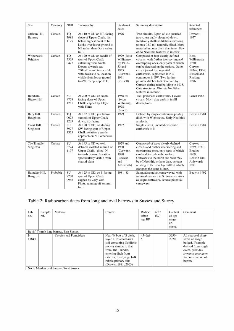
15
Site Category NGR Topography Fieldwork dates
Summary description Selected references
Offham Hill, Hamsey
Certain TQ 3988 1175
At 110 m OD on NE-facing slope of Upper Chalk, just below highest point of hill. Looks over lower ground to NE rather than Ouse valley to E
1976 Two circuits, E part of site quarried away, rest badly ploughed-down. Relatively shallow ditches (surviving to max 0.80 m), naturally silted. More material in outer ditch than inner. Few or no Neolithic features in interior.
Drewett 1977
Whitehawk, Brighton
Certain TQ 3303 0477
At 120 m OD on saddle of spur of Upper Chalk extending from South Downs towards sea. ‘Tilted’ to and intervisible with downs to N, location visible from lower ground to SW. Steep slope to E.
1929 (Ross Williamson); 1932–33 and 1935 (Curwen); 1991 (Russell)
Composed of four clearly-defined circuits, with further intersecting and overlapping ones, only parts of which can be detected on the surface. Outer circuit joined by tangential earthworks, segmented in NE, continuous in SW. Two further possible ditches to S observed by Curwen during road building in 1935. Gate structures. Discrete Neolithic features in interior.
Ross Williamson 1930; Curwen 1934a; 1936; Russell and Rudling 1996
Barkhale, Bignor Hill
Certain SU 9758 1261
At 200 m OD, on south-facing slope of Upper Chalk, capped by Clay-with-Flints
1958–61 (Seton Williams); 1978 (Leach)
Well preserved earthworks, 1 ovoid circuit. Much clay and silt in fill descriptions
Leach 1983
Bury Hill, Houghton
Certain TQ 0023 1203
At 152 m OD, just below summit of Upper Chalk down, SE-facing
1979 Defined by single continuous pit-dug ditch with W entrance. Early Neolithic artefacts.
Bedwin 1981
Court Hill, Singleton
Certain SU 8977 1375
At 180 m OD, on sloping SW-facing spur of Upper Chalk, relatively gentle approach on NE, otherwise steep
1982 Single circuit, undated crescentic earthwork to N
Bedwin 1984
The Trundle, Singleton
Certain SU 8774 1107
At 195 m OD on well defined, isolated summit of Upper Chalk, ‘tilted’ N towards downs. Location spectacularly visible from coastal plain
1928 and 1930 (Curwen); 1980 (Bedwin and Aldsworth)
Composed of three clearly defined circuits and further intersecting and overlapping ones, only parts of which can be detected on the surface. Outworks to the north and west may be of Neolithic or later date, perhaps relating to the Iron Age hillfort which occupies the same hilltop.
Curwen 1929; 1931; Bradley 1969; Bedwin and Aldsworth 1981
Halnaker Hill, Boxgrove
Probable SU 9200 0965
At 125 m OD, on S-facing spur of Upper Chalk capped by Clay-with-Flints, running off summit to E
1981–83 Subquadrangular, causewayed, with inturned entrance in S. Some survives as slight earthwork, several potential causeways.
Bedwin 1992
Table 2: Radiocarbon dates from long and oval barrows in Sussex and Surrey
Lab no.
Sample ref.
Material Context Radiocarbon age BP
δ13C
(‰) Calibrated age range (2-sigma
Comment
Bevis’ Thumb long barrow, East Sussex
I-11843
Corylus and Pomoideae Near W butt of S ditch, layer 8. Charcoal-rich soil containing Neolithic pottery similar to that from The Trundle, entering ditch from exterior, overlying chalk rubble primary silts (Drewett 1981; 2003)
4546±95
3630–2920
All charcoal short-lived, although bulked. If sample derived from single event, provides terminus ante quem for construction of barrow
North Marden oval barrow, West Sussex
16
Lab no.
Sample ref.
Material Context Radiocarbon age BP
δ13C
(‰) Calibrated age range (2-sigma
Comment
HAR-5544
Sample 3
Charcoal : 9 g Quercus sp., 8 g Corylus sp., 5 g Fraxinus sp. Note on charcoal from the site: ‘About 80% of the charcoal fragments identified appear to have come from brushwood-sized timber; the rest of the fragments (where discernible) derive from larger branches or trunk material’ (Cartwright 1986, microfiche frm.25)
Segment 6, context 65. Area of charcoal c. 1 x 1.4 m with Neolithic Bowl pottery, lithics, and adult male cranium within loose chalk rubble derived from barrow in recut of short segment at W end of mound (Drewett 1986, 35, 41, 42, 49)
4710±110
3710–3100
Bulked sample contained long-lived species and could have contained mature wood. Provides terminus
post quem for context.
HAR-5542
Sample 1
1 g Fraxinus sp., 2 g Ulex sp., 6 g Quercus sp. (Cartwright 1986, microfiche frame 24). Same general note as for HAR-5544
Ditch segment 4, context 25. Patch of ashy loam in upper ditch fill, containing burnt flint and bone and Peterborough and Beaker pottery (Drewett 1986, 33, 42, fig. 5)
3550±80
2140–1680
As above
HAR-5543
Sample 2
12 g Fraxinus sp, 6 g Corylus sp., 2 g Quercus sp., 1 g. Crataegus sp, 1 g Betula sp. (Cartwright 1986, microfiche frame 24). Same general note as for HAR-5544
Ditch segment 5, context 55. Topmost fill of ditch (Drewett 1986, fig. 5: I–J).
3590±80
2200–1730
As above
Alfriston oval barrow, East Sussex
HAR-940
ALF1 Red deer. Antler pick (Drewett 1975, fig. 12: 34)
Ditch 2, layer 6. Bottom layer of ditch. , with struck flint of early Neolithic character and, at an equivalent level in an adjoining length of ditch, a few sherds probably from a single indeterminate Bowl (Drewett 1975, 126, 151, fig. 3, fig. 7: O–P)
4310±110
˗22.5 3340–2620
Single-entity sample in apparent functional relation to context, but date surprisingly late for associated artefacts. Discrepancy between HAR-942 (measured at the same time as HAR-940) and HAR-1811 (measured later) raises possibility that HAR-940 may be too young. See text.
HAR-942
ALF4 Human. Bones of one leg from articulated crouched burial probably female adult. (Drewett 1975, 126, 144–5, 151, fig. 8. pl XII; Jordan et
al. 1994, 4). Replicate of HAR-1811
Base of burial pit on axis of mound of oval barrow. Stratigraphic relation to mound uncertain because mound badly ploughed, and because of cut made into mound in area of grave in C19 (Drewett 1975, 121–7, figs 4, 5)
2590±90
˗23.5 910–415
HAR-942 and -1811, measured on two legs of the same individual, cannot both be accurate. See text.
HAR-1811
Replicate of HAR-942, on bones of second leg of same individual
From the same burial as HAR-942
3190±80
˗22.5 1665–1270
As above
HAR-941
A1 Red deer. Antler pick On buried land surface c. 2.5 m N of burial pit (Drewett 1975, 124, fig. 3)
2540±70
˗23.3 830–400
Some doubt must hang over accuracy of this measurement, since it was made at the same time as HAR-942. See text
Badshot, Surrey
BM-2274R
B.IV.3 Red deer antler beam Primary chalk silting of north ditch, cutting B4, where there were two leaf arrowheads (Keiller and Piggott 1939, 133–35, fig. 53: section E–F)
4860±180
˗21.4 4045–3100
Large standard deviation and wide probability distribution result from the application of a correction following discovery of counting error in 1980s (Bowman et
al. 1990)

17
Lab no.
Sample ref.
Material Context Radiocarbon age BP
δ13C
(‰) Calibrated age range (2-sigma
Comment
BM-2273N1
B.IV.3 (F)
Cattle vertebrae, probably articulating, since they are described as 5th and 6th cervical vertebrae and 3 thoracic vertebrae, all with unfused epiphyses (Keiller and Piggott 1939, 147–48). Replicate of BM-2273N2, -2273N3
From the same context as BM-2274R
4780±40
BM-2273N2
B.IV.3 (F)
Replicate of BM-2273N1, -2273N3 From the same context as BM-2274R
4710±50
BM-2273N3
B.IV.3 (F)
Replicate of BM-2273N1, -2273N2 From the same context as BM-2274R
4730±50
3640–3380
Weighted mean 4746±27 BP (T' =1.3; T' (5%)=6; í=2 ) Three replicates measured in course of correction of counting error discovered in 1980s (Bowman et al. 1990)
BM-2272R
B.IV.3 (G)
Bone fragments Red brown loam at E terminal of N ditch, stratified above other samples, associated with sherds of a Mortlake style Bowl (Keiller and Piggott 1939, 138–39, 142–43, fig. 53: section E–F)
4640±130
˗22.6 3655–2940
Large standard deviation and wide probability distribution result from the application of a correction following discovery of counting errors in the early 1980s (Bowman et al. 1990) Bulked, unidentified sample provides terminus post quem for context
References Adkins, R, and Jackson, R, 1978 Neolithic Stone and Flint Axes from the River Thames. British Museum Occasional Paper 1. London: British Museums Alexander, J, 1961 The excavation of the Chestnuts megalithic tomb at Addington, Kent, Archaeologia Cantiana 76, 1–57 Allen, M J, and Leivers, M, forthcoming Neolithic causewayed enclosures and later prehistoric farming: duality, imposition and the role of predecessors at Kingsborough, Isle of Sheppey, Kent, UK, Proceedings of the Prehistoric Society. Allen, T, Barclay, A, and Lamdin-Whymark, H, 2004 Opening the wood, making the land: the study of a Neolithic landscape in the Dorney area of the middle Thames valley. In J Cotton and D Field (eds), Towards a New Stone Age: Aspects of the Neolithic in South-east England, 82–98. Council for British Archaeology Research Report 137; York, Council for British Archaeology Ambers, J, 2003 The radiocarbon dating. In Ford, S, and Pine, J, Neolithic ring ditches and Roman landscape features at Horton (1989 to 1996). In S Preston (ed), Prehistoric, Roman and Saxon Sites in
Eastern Berkshire: excavations 1989–1997, 60–62. Thames Valley Archaeological Services Ltd Monograph 2; Reading, Thames Valley Archaeological Services Ltd Ambers, J, and Bowman, S, 2003. Radiocarbon measurements from the British Museum: datelist XXVI. Archaeometry 45(3), 531–40 Ambers, J, Burleigh, R, and Matthews, K, 1987 British Museum natural radiocarbon measurements XIX, Radiocarbon 29(1) 61–77
18
Anon 1856 Catalogue of Antiquities exhibited in the museum formed during the annual meeting of the Archaeological Institute held at Chichester in July 1853, Sussex Archaeological Collections 8, 36–44 Ashbee, P, 1993 The Medway megaliths in perspective, Archaeologia Cantiana 111, 57–111 Ashbee, P, 1999 The Medway megaliths in a European context, Archaeologia Cantiana 119, 269–84 Ashbee, P, 2004 The Neolithic in Kent. In T Lawson and D Killingray (eds), An Historical Atlas of
Kent, 10–12 Ashbee, P, 2005 Kent in Prehistoric Times. Stroud: Tempus Ashmore, P, 1999 Radiocarbon dating: avoiding errors by avoiding mixed samples, Antiquity 73, 124-30 Bamford, H M, 1985 Briar Hill. Excavation 1974–1978. Northampton Development Corporation Archaeological Monograph 3; Northampton: Northampton Development Corporation Barber, M, 1997 Landscape, the Neolithic, and Kent. In P Topping (ed), Neolithic Landscapes, 77–85. Neolithic Studies group Seminar Papers 2; Oxbow Monograph 86; Oxford: Oxbow Books Barber, M, 2004 ‘Rubbishy pots instead of gold’: a brief history of the Neolithic in the South East. In J Cotton and D Field (eds), Towards a New Stone Age: Aspects of the Neolithic in South-east England, 1–11. London: Council for British Archaeology Research Report 137 Barber, M, 2005 Mining, burial and chronology: the West Sussex flint mines. In P Topping and M Lynott (eds), The Cultural Landscape of Prehistoric Mines, 94–109. Oxford and Oakville: Oxbow Books Barber, M, Field, D, and Topping, P, 1999 The Neolithic Flint Mines of England. Swindon: English Heritage Barclay, A, and Case, H, 2007. The early Neolithic pottery and fired clay. In D Benson and A Whittle (eds), Building Memories. The Neolithic Cotswold Long Barrow at Ascott-under-Wychwood,
Oxfordshire, 331-44. Oxford: Oxbow Books Barclay, A, Lambrick, G, Moore, J, and Robinson, M, 2003 Lines in the Landscape. Cursus
Monuments in the Upper Thames Valley: excavations at the Drayton and Lechlade cursuses. Thames Valley Landscapes Monograph 15; Oxford: Oxford Archaeology Barker, H, and Mackey, C J, 1959 British Museum natural radiocarbon measurements I, Radiocarbon 1, 81–6 Barker, H, Burleigh, R, and Meeks, N, 1969 British Museum radiocarbon measurements VI,
Radiocarbon 11(2), 278−94
Bates, M R, and Whittaker, K, 2004 Landscape evolution in the lower Thames valley: implications for the archaeology of the earlier Holocene period. In J Cotton and D Field (eds), Towards a New Stone
Age: aspects of the Neolithic in South-east England, 50–70. London: Council for British Archaeology Research Report 137 Bayliss, A, and Bronk Ramsey, C, 2004 Pragmatic Bayesians: a decade integrating radiocarbon dates into chronological models. In C E Buck and A R Millard (eds), Tools for Constructing Chronologies:
tools for crossing disciplinary boundaries, 25–41. London: Springer Bayliss, A, Bronk Ramsey, C, van der Plicht, J, and Whittle, A, 2007a Bradshaw and Bayes: towards a timetable for the Neolithic, Cambridge Journal of Archaeology 17 (1; supplement), 1–28

19
Bayliss, A, Benson, D, Galer, D, Humphrey, L, McFadyen, L and Whittle, A, 2007b One thing after another: the date of the Ascott-under-Wychwood long barrow, Cambridge Archaeological Journal 17 (1, supplement), 29–44 Bayliss, A, and Whittle, A (eds), 2007 Histories of the dead: building chronologies for five southern British long barrows, Cambridge Archaeological Journal 17 (1) supplement Bayliss, A, Whittle, A, and Healy, F, forthcoming Timing, tempo and temporalities in the early Neolithic of southern Britain Bedwin, O, 1981 Excavations at the Neolithic enclosure on Bury Hill, Houghton, West Sussex, 1979, Proceedings of the Prehistoric Society 47, 69–86 Bedwin, O, 1984 The excavation of a small hilltop enclosure on Court Hill, Singleton, W. Sussex, Sussex Archaeological Collections 122, 13–22 Bedwin, O, 1992 Prehistoric earthworks on Halnaker Hill, West Sussex, excavations 1981–1983, Sussex Archaeological Collections 130, 1–12 Bedwin, O, and Aldsworth, F, 1981 Excavations at The Trundle, 1981, Sussex Archaeological
Collections 119, 208–14 Bell, M, 1977 Excavations at Bishopstone, Sussex, Sussex Archaeological Collections 115, 1–299 Bennett, F J, 1913 Coldrum monument and exploration 1910, Journal of the Royal Anthropological
Institute of Great Britain and Ireland 43, 76–85 Benson, D, and Whittle, A (eds), 2007 Building Memories. The Neolithic Cotswold Long Barrow at
Ascott- under-Wychwood, Oxfordshire. Oxford: Oxbow Books Bewley, B, Crutchley, S, and Grady, D, 2004 Aerial survey and its contribution to understanding the Neolithic of the south-east. In J Cotton and D Field (eds), Towards a New Stone Age: aspects of the
Neolithic in South-east England, 71–5. London: Council for British Archaeology Research Report 137 Bird, D G, Crocker, G, and McCracken, J S, 1990 Archaeology in Surrey 1988–1989, Surrey
Archaeological Collections 80, 201–27 Bowman, S G E, Ambers, J C, and Leese, M N, 1990 Re-evaluation of British Museum radiocarbon dates issued between 1980 and 1984, Radiocarbon 32(1), 59–79 Bradley, P, 2004Causewayed enclosures: monumentality, architecture, and spatial distribution of artefacts - the evidence from Staines, Surrey. In J Cotton and D Field (eds), Towards a New Stone
Age: aspects of the Neolithic in South-east England, 115–23. London: Council for British Archaeology Research Report 137 Bradley, R, 1969 The Trundle revisited, Sussex Notes and Queries 17, 133–4 Bradley, R, 1982 Belle Tout - revision and reassessment. In P Drewett, The Archaeology of Bullock
Down, Eastbourne, East Sussex: the development of a landscape. Sussex Archaeological Society Monograph 1, 62–71. Lewes: Sussex Archaeological Society Bradley, R, and Gordon, K, 1988 Human skulls from the river Thames, their dating and significance, Antiquity 62(236), 503–9 Bronk Ramsey, C, 1995 Radiocarbon calibration and analysis of stratigraphy, Radiocarbon 36, 425–30

20
Bronk Ramsey, C, 1998 Probability and dating, Radiocarbon 40, 461–74 Bronk Ramsey, C, 2000, Comment on ‘The Use of Bayesian Statistics for 14C dates of chronologically ordered samples: a critical analysis’, Radiocarbon 42 (2) 199-202 Bronk Ramsey, C, 2001 Development of the radiocarbon calibration program Oxcal. Radiocarbon 43, 355–63 Bronk Ramsey, C, Higham, T F, Bowles, A, and Hedges, R E M, 2004a Improvements to the pre- treatment of bone at Oxford, Radiocarbon 46, 155–63 Bruce-Mitford, R, 1938 A hoard of Neolithic axes from Peaslake, Surrey, Antiquaries Journal 18, 279–84 Buck, C E, Cavanagh, W G, and Litton, C D, 1996 Bayesian Approach to Interpreting Archaeological
Data. Chichester: Wiley Burleigh, R, Hewson, A, and Meeks, N, 1976 British Museum natural radiocarbon measurements VIII, Radiocarbon 18(1), 16–42 Carew, T, Bishop, B, Meddens, F, and Ridgeway, V, 2006 Unlocking the Landscape. Archaeological
Excavations at Ashford Prison, Middlesex. Pre-Construct Archaeology Limited, Monograph 5; London: Pre-Construct Archaeology Cartwright, C, 1986 The charcoal. In P L Drewett, The excavation of a Neolithic oval barrow at North Marden, West Sussex, 1982, Proceedings of the Prehistoric Society 52, 42 Clark, J G D, 1932 The curved flint sickle blades of Britain. Proceedings of the Prehistoric Society of
East Anglia 7, 67–81 Clark, J G D, 1934 The flint implements. In E C Curwen, A late Bronze Age farm and a Neolithic pit-dwelling on New Barn Down, Clapham, Nr. Worthing, Sussex Archaeological Collections 75, 164–6 Clarke, A F, 1982 The Neolithic of Kent: a review. In P Leach (ed), Archaeology in Kent to AD 1500, 25–30. London: Council for British Archaeology Research Report 48 Cleal, R M J, 2004 The dating and diversity of the earliest ceramics of Wessex and south-west England. In Cleal, R and Pollard, J (eds), Monuments and Material Culture: papers in honour of an
Avebury archaeologist: Isobel Smith, 166–92. East Knoyle: Hobnob Press Coles, B, and Coles, J, 1986 Sweet Track to Glastonbury. London: Thames and Hudson Coles, S, Ford, S, and Taylor, A, forthcoming An early Neolithic grave and occupation, and an early Bronze Age hearth on the Thames foreshore at Yabsley Street, Blackwall, London Cotton, J, 2004 Surrey’s early past: a survey of recent work. In J Cotton, G Crocker, and A Graham (eds), Aspects of Archaeology and History in Surrey: towards a research framework for the county, 19–38. Guildford: Surrey Archaeological Society Craddock, P T, Cowell, M R, Leese, M N, and Hughes, M J, 1983 The trace element composition of polished flint axes as an indicator of source, Archaeometry 25, 135–63 Curwen, E C, 1929a Hoard of celts from Sussex, Antiquaries Journal 9, 42–43 Curwen, E C, 1929b Excavations in The Trundle, Goodwood, 1928, Sussex Archaeological
Collections 70, 33–85

21
Curwen, E C, 1929c Clayton Hill hoard of celts, Antiquaries Journal 9, 152 Curwen, E C, 1931 Excavations in the Trundle, Goodwood (second season) 1930, Sussex
Archaeological Collections 72, 100–49 Curwen, E C, 1934a Excavations at Whitehawk Camp, Brighton 1932–3, Antiquaries Journal 14, 99–113 Curwen, E C, 1934b A late Bronze Age farm and a Neolithic pit-dwelling on New Barn Down, Clapham, Nr. Worthing, Sussex Archaeological Collections 75, 137–70 Curwen, E C, 1936 Excavations in Whitehawk Camp, Brighton, third season, 1935, Sussex
Archaeological Collections 77, 60–92 Daniel, G, 1950 The Prehistoric Chambered Tombs of England and Wales, Cambridge: Cambridge University Press Densem, R, and Seeley, D, 1982 Excavations at Rectory Grove, Clapham, 1980–1, The London
Archaeologist 4.7, 177–84
Down, A, and Welch, M, 1990 Chichester Excavations VII. Chichester: Chichester District Council Drewett, P L, 1977 The excavation of a Neolithic causewayed enclosure at Offham Hill, East Sussex, 1976, Proceedings of the Prehistoric Society 43, 201–42 Drewett, P L, 1975 The excavation of an oval burial mound of the third millennium B.C. at Alfriston, East Sussex, 1974, Proceedings of the Prehistoric Society 41, 119–52 Drewett, P L, 1981 A sample excavation at Bevis’s Thumb, Compton, West Sussex, University of
London Bulletin of the Institute of Archaeology 18, 22–24 Drewett, P L, 1982 The Archaeology of Bullock Down, Eastbourne, East Sussex: the development of a
landscape. Sussex Archaeological Society Monograph 1. Lewes: Sussex Archaeological Society Drewett, P L, 1985 Neolithic pottery. In O Bedwin and R Holgate, Excavations at Copse Farm, Oving, West Sussex, Proceedings of the Prehistoric Society 51, 220–1 Drewett, P L, 1986 The excavation of a Neolithic oval barrow at North Marden, West Sussex, 1982, Proceedings of the Prehistoric Society 52, 31–52 Drewett, P L, 1994 Dr V Seton Williams’ excavations at Combe Hill, 1962, and the role of Neolithic causewayed enclosures in Sussex, Sussex Archaeological Collections 132, 7–24 Drewett, P L, 2003 Taming the wild: the first farming communities in Sussex. In D Rudling (ed.), The
Archaeology of Sussex to AD 2000, 39–46. Great Dunham: Heritage Marketing and Publications Ltd Drewett, P L, and Bedwin, O, 1981 Appendix: note on radiocarbon dates from Neolithic enclosures in Sussex. In O Bedwin, Excavations at the Neolithic enclosure on Bury Hill, Houghton, West Sussex, 1979, Proceedings of the Prehistoric Society 47, 86 Drewett, P L, Rudling, D, and Gardiner, M, 1988 The South East to AD 1000. London: Longman Dunning, G C, 1966 Neolithic occupation sites in east Kent, Antiquaries Journal 46, 1–25 Dyson, L, Shand, G, and Stevens, S, 2000 Causewayed enclosures, Current Archaeology 168, 470–2
22
Edmonds, M, 1995 Stone Tools and Society: working stone in Neolithic and Bronze Age Britain.
London: Batsford Edmonds, M, 1999 Ancestral Geographies of the Neolithic: landscapes, monuments and memory. London and New York: Routledge Ellaby, R, 2004 Food for thought: a late Mesolithic site at Charlwood, Surrey. In J Cotton and D Field (eds), Towards a New Stone Age: aspects of the Neolithic in South-east England, 12–23. London: Council for British Archaeology Research Report 137 Ellis, C J, 2004 A Prehistoric Ritual Complex at Eynesbury, Cambridgeshire: excavation of a multi-
period site in the Great Ouse Valley, 2000–2001. East Anglian Archaeology Occasional Paper 17. Salisbury: Trust for Wessex Archaeology Ltd Evans, J G, 1972 Land Snails in Archaeology. London: Seminar Press Evans, J G, Rouse, A, and Sharples, N, 1988 The landscape setting of causewayed camps: recent work on the Maiden Castle enclosure. In J C Barrett and I Kinnes (eds), The Archaeology of Context in the
Neolithic and Bronze Age: recent trends, 73–78. Sheffield: Department of Archaeology and Prehistory Field, D, 2004a Sacred geographies in the Neolithic of south-east England. In J Cotton and D Field (eds), Towards a New Stone Age: aspects of the Neolithic in South-east England, 154–63. London: Council for British Archaeology Research Report 137 Field, D, 2004b Use of Land in Central Southern England during the Neolithic and Early Bronze Age. Unpublished PhD thesis, University of Reading Field, D, and Cotton, J, 1987 Neolithic Surrey: a survey of the evidence. In J Bird and D G Bird (eds), The Archaeology of Surrey to 1540, 71–96. Guildford: Surrey Archaeological Society Fitzpatrick, A P, 1997 Archaeological Excavations on the Route of the A27 Westhampnett Bypass,
West Sussex, 1992. Wessex Archaeology Report 12. Salisbury: Wessex Archaeology Ford, S, and Pine, J, 2003 Neolithic ring ditches and Roman landscape features at Horton (1989 to 1996). In S Preston (ed.), Prehistoric, Roman and Saxon Sites in Eastern Berkshire: excavations
1989–1997, 13–85. Thames Valley Archaeological Services Ltd Monograph 2. Reading: Thames Valley Archaeological Services Ltd Archaeological Services Ltd Framework Archaeology, 2006 Landscape Evolution in the Middle Thames Valley: Heathrow
Terminal 5 excavations Volume 1, Perry Oaks. Framework Archaeology Monograph 1. Oxford and Salisbury: Framework Archaeology Gardiner, J, 1984 Lithic distributions and settlement patterns in central southern England. In R Bradley and J Gardiner (eds), Neolithic Studies, 15–40. British Archaeological Reports British Series 133. Oxford: British Archaeological Reports Gardiner, J, 1990 Flint procurement and Neolithic axe production on the South Downs: a re- assessment, Oxford Journal of Archaeology 9(2), 119–40 Gardiner, J, 2001 Catalogue of surviving flintwork from the Worthing group of mines. In M Russell,
Rough Quarries, Rocks and Hills: John Pull and the Neolithic flint mines of Sussex, 202−23. Bournemouth University School of Conservation Sciences Occasional Paper 8. Oxford: Oxbow Books Gates, T 1975 The Middle Thames Valley. An Archaeological Survey of the River Gravels. Berkshire Archaeological Committee Publication 1. Reading: Berkshire Archaeological Committee

23
Gibson, A, 2002a The pottery, Neolithic and early Bronze Age. In G Shand, Excavations at Chalk
Hill, near Ramsgate, Kent 1997–8: integrated assessment and updated research design, 13–15. Unpublished document. Canterbury: Canterbury Archaeological Trust Gibson, A, forthcoming The Neolithic pottery from Cross Roads and St Richards Road, Deal. Prepared for the Canterbury Archaeological Trust Gillespie, R, 1989 Fundamentals of bone degradation chemistry: collagen is not ‘the way’, Radiocarbon 32(3), 239–46 Gillespie, R, Hedges, R E M, and Humm, M J, 1986 Routine AMS dating of bone and shell proteins. , Radiocarbon 28 (2A), 451–6 Green, HS, 1980 The Flint Arrowheads of the British Isles. British Archaeological Reports British Series 75. Oxford: British Archaeological Reports Greenfield, E, 1960 A Neolithic pit and other finds from Wingham, East Kent, Archaeologia Cantiana 74, 58–72
Hammond, J, 2007 How Kent’s recently discovered causewayed enclosures impact on our understanding and interpretation of the early Neolithic in the region, Archaeologia Cantiana 127, 357–82 Harding, A F, and Ostoja-Zagórski, J, 1987 Excavations in Rocks Wood, Withyham, Sussex
Archaeological Collections 125, 11–32 Harding, J, and Healy, F, 2007 The Raunds Area Project. A Neolithic and Bronze Age Landscape in
Northamptonshire. Swindon: English Heritage Hayden, C, forthcoming The prehistoric landscape at White Horse Stone, Aylesford, Kent. CTRL integrated site report series, http://ads.ahds.ac.uk/catalogue/projArch/ctrl Healy, F, 2004 Hambledon Hill and its implications. In R M J Cleal and J Pollard (eds), Monuments
and Material Culture: papers in honour of an Avebury archaeologist: Isobel Smith, 15–38. East Knoyle: Hobnob Books Hedges, J D, 1980 The Neolithic in Essex. In D G Buckley (ed.), Archaeology in Essex to AD 1500, 26–39. London: Council for British Archaeology Research Report 34 Hedges, R E M, and Law, I A, 1989 The radiocarbon dating of bone, Applied Geochemistry 4, 249–53 Hedges, R E M, and van Klinken, G J, 1992 A review of current approaches in the pretreatment of bone for radiocarbon dating by AMS, Radiocarbon 34, 279–91. Hillam, J, Groves, C M, Brown, D M, Baillie, M G L, Coles, J M, and Coles, B J, 1990 Dendrochronology of the English Neolithic, Antiquity 64, 210–20 Holgate, R, 1981 The Medway megaliths and Neolithic Kent, Archaeologia Cantiana 97, 221–34 Holgate, R, 1995a GB4 Harrow Hill near Findon, West Sussex, Archaeologia Polonia 33, 347–50 Holgate, R, 1995b GB 6 Long Down near Chichester, West Sussex, Archaeologia Polonia 33, Archaeologia Polonia 33, 350–52 Holleyman, G, 1937 Harrow Hill excavations, 1936, Sussex Archaeological Collections 78, 230–51

24
Jacobi, R M, 1982 Later hunters in Kent: Tasmania and the earliest Neolithic. In P Leach (ed), Archaeology in Kent to AD 1500, 12–24. London: Council for British Archaeology Research Report 48 James, B, 1977 The flint industry. In P Drewett, The excavation of a Neolithic causewayed enclosure at Offham Hill, East Sussex, 1976, Proceedings of the Prehistoric Society 43, 211–18 Jessup, R F, 1937 Excavations at Julliberrie’s Grave, Chilham, Kent, Antiquaries Journal 17, 122–37 Jessup, R F, 1939 Further excavations at Julliberrie’s Grave, Chilham, Antiquaries Journal 19, 260–81 Jordan, D, Haddon-Reece, D, and Bayliss, A, 1994 Radiocarbon Dates from Samples Funded by
English Heritage and Dated before 1981. London: English Heritage Keiller, A, and Piggott, S, 1939 Badshot long barrow. In K P Oakley, W F Rankine and A W G Lowther, A Survey of the Prehistory of the Farnham District (Surrey), 133–49. Guildford: Surrey Archaeological Society Keith, A, 1913 Report on the human remains found by F J Bennett, Esq., F G S, in the central chamber of a megalithic monument at Coldrum, Kent, Journal of the Royal Anthropological Institute of Great
Britain and Ireland 43, 86–100 Keith-Lucas, M, 2000 Pollen analysis of sediments from Moor Farm, Staines Moor, Surrey, Surrey
Archaeological Collections 87, 85–93 Kennard, A S, 1939 Report on the non-marine Mollusca. In R.F. Jessup, Further excavations at Julliberrie’s Grave, Chilham, Antiquaries Journal 19, 279–80 Kinnes, I, 1992 Non-Megalithic Long Barrows and Allied Structures in the British Neolithic. British Museum Occasional Paper 52. London: British Museum Lane Fox, 1876 Excavations in Cissbury Camp, Sussex: being a report of the Exploration Committee of the Anthropological Institute for the year 1975, Journal of the Anthropological Institute 5, 357–90 Lavender, N, 1995 Brightlingsea, ring ditch at Moverons Pit (TM 070 183). In P J Gilman and A Bennett (eds), Archaeology in Essex 1994, Essex Archaeology and History 26, 242 Lavender, N, 1996 Brightlingsea, ring ditch at Moverons Pit (TM 070 183). In P J Gilman and A Bennett (eds), Archaeology in Essex 1994. Essex Archaeology and History 27, 266 Lavender, N, and Clarke, P, forthcoming An early Neolithic ring-ditch and Bronze Age cemetery at Brightlingsea, Essex: excavations and survey 1989–95 Leach, P E, 1983 The excavation of a Neolithic causewayed enclosure on Barkhale Down, Bignor Hill, West Sussex. Sussex Archaeological Collections 121, 11–30 Lewis, J, 2000 The Neolithic period. In MoLAS, The Archaeology of Greater London: an assessment
of archaeological evidence for human presence in the area now covered by Greater London, 63–80. MoLAS monograph. London: Museum of London Longin, R, 1971 New method of collagen extraction for radiocarbon dating, Nature 230, 241–2 Maby, J C, 1950 Ancient charcoals. In R Musson, An excavation at Combe Hill camp near Eastbourne, August 1949, Sussex Archaeological Collections 89, 115 Macpherson-Grant, N, 1969 Two Neolithic Bowls from Birchington, Thanet, Archaeologia Cantiana 4, 249–50

25
Magilton, J, 1998 Sussex’s first henge? Sussex Past and Present. The Sussex Archaeological Society
Newsletter 84, 4–5
Malim, T, 1999 Cursuses and related monuments of the Cambridgeshire Ouse. In A Barclay and J Harding (eds), Pathways and Ceremonies: the cursus monuments of Britain and Ireland, 77–85. Neolithic Studies Group Seminar Papers 4. Oxford and Oakville: Oxbow Books Malim, T, 2000 The ritual landscape of the Neolithic and Bronze Age along the middle and lower Ouse valley. In M Dawson (ed), Prehistoric, Roman, and Post-Roman Landscapes of the Great Ouse
Valley, 57–88. London: Council for British Archaeology Research Report 119 McAvoy, F, 2000 The development of a Neolithic monument complex at Godmanchester, Cambridgeshire. In M Dawson (ed), Prehistoric, Roman, and Post-Roman Landscapes of the Great
Ouse Valley, 51–56. London: Council for British Archaeology Research Report 119
McNabb, J, Felder, P J, Kinnes, I, and Sieveking, G, 1996 An archive report on recent excavations at Harrow Hill, Sussex, Susex Archaeological Collections 134, 21–37 Meadows, J, Barclay, A, and Bayliss, A, 2007 A short passage of time: the dating of the Hazleton long cairn revisisted, Cambridge Archaeological Journal 17 (1, supplement), 45–64 Mercer, R J, 1990 Causewayed Enclosures. Princes Risborough: Shire Publications Money, J H, 1960 Excavation at High Rocks, Tunbridge Wells, 1954–1956, Sussex Archaeological
Collections 98, 173–222 Money, J H, 1962 Excavations at High Rocks, Tunbridge Wells, 1954–1956: supplementary note, Sussex Archaeological Collections 100, 149–50 Museum of London Archaeology Service 1999 Tollgate ARC TLG 98 Archaeological Excavation
Interim Report, http://ads.ahds.ac.uk/catalogue/projArch/ctrl Musson, R, 1950 An excavation at Combe Hill camp near Eastbourne, August 1949, Sussex
Archaeological Collections 89, 105–16 Needham, S P, 1991 Excavation and Salvage at Runnymede Bridge, 1978: the Late Bronze Age
Waterfront Site. London: British Museum Press. Needham, S P, 2000 The Passage of the Thames: Holocene environment and settlement at
Runnymede. Runnymede Bridge Research Excavations, Volume 1. London: British Museum Press. Needham, S P and Trott, M R, 1987 Structure and sequence in the Neolithic deposits at Runnymede, Proceedings of the Prehistoric Society 53, 479–98 Oswald, A, Dyer, C, and Barber, M, 2001 The Creation of Monuments. Swindon: English Heritage. Oxford Archaeological Unit 1995 Tollgate Cropmark Complex, Gravesham, Kent. Archaeological
Evaluation Report TIS no. 192/84-10411, http://ads.ahds.ac.uk/catalogue/projArch/ctrl Parfitt, K, 1998 Neolithic earthen long barrows in east Kent: a review, Kent Archaeological Review
131, 15–21 Parfitt, K, and Halliwell, G, 1983 A Mesolithic site at Finglesham, Kent Archaeological Review 72, 29–32

26
Parfitt, K, and Halliwell, G, 1988 Thermoluminescence dates for two prehistoric sites in east Kent, Kent Archaeological Review 94, 79–80 Payne, G., 1880. Celtic remains discovered at Grovehurst, Milton, Archaeologia Cantiana 13, 122–6 Peglar, S, 2006 The Ouse channel Flandrian sequence. In C Evans and I Hodder, A Woodland
Archaeology: Neolithic aites at Haddenham. The Haddenham Project Volume 1, 26–9. Cambridge: MacDonald Institute for Archaeological Research Peglar, S, and Waller, M, 1994 The Ouse channel, Haddenham. In M Waller, The Fenland Project,
Number 9: Flandrian Environmental Change in Fenland, 47–84. East Anglian Archaeology Report 70 Perkins, D, 2004 Oval barrows on Thanet. In J Cotton and D Field (eds), Towards a New Stone Age:
aspects of the Neolithic in South-east England, 76–81. London: Council for British Archaeology Research Report 137 Piggott, S, 1931 The Neolithic pottery of the British Isles, Archaeological Journal 88, 67–158 Piggott, S, 1934 The neolithic pottery. In EC Curwen, A late Bronze Age farm and a Neolithic pit-dwelling on New Barn Down, Clapham, Nr. Worthing, Sussex Archaeological Collections 75, 162–4 Piggott, S, 1935 A note on the relative chronology of the English long barrows, Proceedings of the Prehistoric Society 1, 115–26 Piggott, S, 1954 Neolithic Cultures of the British Isles. Cambridge: Cambridge University Press Pitts, M, 1996 The stone axe in Neolithic Britain, Proceedings of the Prehistoric Society 62, 311–37 Pryor, F, 1998 Etton: Excavations at a Neolithic Causewayed Enclosure near Maxey, Cambridgeshire,
1982–87. London: English Heritage Archaeological Report 18 Rankine, W F, 1939 Mesolithic and Neolithic studies. In K P Oakley, W F Rankine and A W G Lowther, A Survey of the Prehistory of the Farnham District (Surrey), 61–132. Guildford: Surrey Archaeological Society Reimer, P J, Baillie, M G L, Bard, E, Bayliss, A, Beck, J W, Bertrand, C J H, Blackwell, P G, Buck, C E, Burr, G S, Cutler, K B, Damon, P E, Edwards, R L, Fairbanks, R G, Friedrich, M , Guilderson, T P, Hogg, A G, Hughen, K A, Kromer, B, McCormac, F G, Manning, S, Bronk Ramsey, C, Reimer, R W, Remmele, S, Southon, J R, Stuiver, M, Talamo, S, Taylor, F W, van der Plicht, J, and Weyhenmeyer, C E, 2004 IntCal04 terrestrial radiocarbon age calibration, 0–26 cal kyr BP, Radiocarbon 46, 1029–58 Robertson-Mackay, R, 1987 The Neolithic causewayed enclosure at Staines, Surrey: excavations 1961–63, Proceedings of the Prehistoric Society 53, 23–128 Robinson, M, 2000 Neolithic and late Bronze Age insect assemblages. In Needham, S P, The Passage
of the Thames: holocene environment and settlement at Runnymede. Runnymede Bridge Research
Excavations, Volume 1, 146–67. London: British Museum Press Ross Williamson, R P, 1930 Excavations in Whitehawk Neolithic camp, near Brighton, Sussex
Archaeological Collections 71, 56–96 RCHME, 1979 Long Barrows in Hampshire and the Isle of Wight. London: HMSO RCHME, 1995a A Survey of Earthworks at Whitehawk Camp, Brighton, East Sussex. Cambridge: RCHME

27
RCHME, 1995b A Causewayed Enclosure and the Trundle Hillfort on St Roche’s Hill, Singleton, West
Sussex. An Earthwork Survey by the Royal Commission on the Historical Monuments of England. Enclosure and Industry in the Neolithic. Cambridge: RCHME Russell, M, 2001 Rough Quarries, Rocks and Hills: John Pull and the Neolithic flint mines of Sussex. Bournemouth University School of Conservation Sciences Occasional Paper 8. Oxford: Oxbow Books Russell, M, 2004 The treachery of images: deconstructing the early Neolithic monumental architecture of the South Downs. In J Cotton and D Field (eds), Towards a New Stone Age: aspects of the Neolithic
in South-east England, 168–76. London: Council for British Archaeology Research Report 137 Russell, M, and Rudling, D, 1996 Excavations at Whitehawk Neolithic enclosure, Brighton, East Sussex, 1991–1993, Sussex Archaeological Collections 134, 39–61 Saville, A, 1990 Hazleton North, Gloucestershire, 1979–82: the excavation of a Neolithic Long Cairn
of the Cotswold-Severn Group. London: English Heritage Archaeological Report 13 Scaife, R, 2000 Palynology and palaeoenvironment. In S P Needham, The Passage of the Thames:
Holocene environment and settlement at Runnymede. Runnymede Bridge Research Excavations, Volume 1, 168–87. London: British Museum Press Scaife, R, forthcoming. Pollen. In M J Allen and M Leivers, Neolithic causewayed enclosures and later prehistoric farming: duality, imposition and the role of predecessors at Kingsborough, Isle of Sheppey, Kent, UK, Proceedings of the Prehistoric Society Scott, B, 2004 Kentish evidence of the Palaeolithic and Mesolithic periods. In T Lawson and D Killingray (eds), An Historical Atlas of Kent, 7–9 Shand, G, 1998 A Neolithic causewayed enclosure in Kent. PAST 29, 1 Shand, G, 2001 Archaeological Excavations at Chalk Hill, Ramsgate Harbour Approach Road
1997/8. Client Report. Canterbury: Canterbury Archaeological Trust Ltd Shand, G, 2002 Excavations at Chalk Hill, near Ramsgate, Kent 1997–8: integrated assessment and
updated research design. Unpublished document. Canterbury: Canterbury Archaeological Trust Sidell, J, and Wilkinson, K, 2004 The central London Thames: Neolithic river development and floodplain archaeology. In J Cotton and D Field (eds), Towards a New Stone Age: aspects of the
Neolithic in South-east England, 38–70. London: Council for British Archaeology Research Report 137 Smith, I F, 1983 Pottery. In P E Leach, The excavation of a Neolithic causewayed enclosure on Barkhale Down, Bignor Hill, West Sussex, Sussex Archaeological Collections 121, 17–20 Smith, I F. and Darvill, T C, 1990 The prehistoric pottery. In A Saville, Hazleton North,
Gloucestershire, 1979–82: the excavation of a Neolithic Long Cairn of the Cotswold-Severn Group, 141–52. London: English Heritage Archaeological Report 13 Steier, P, and Rom, W, 2000 The use of Bayesian statistics for 14C dates of chronologically ordered samples: a critical analysis, Radiocarbon 42(2), 183–98 Stuiver, M, and Reimer, P J, 1986 A computer program for radiocarbon age calculation, Radiocarbon 28, 1022–30 Tebutt, C F, 1974 The prehistoric occupation of the Ashdown Forest area of the Weald, Sussex
Archaeological Collections 112, 34–43

28
Thomas, J, 1999 Understanding the Neolithic. London: Routledge Thomas, K D, 1975 Appendix V: land Mollusca and the environment of the Alfriston barrow. In P Drewett, The excavation of an oval burial mound of the third millennium BC at Alfriston, East Sussex, 1974, Proceedings of the Prehistoric Society 41, 148–50 Thomas, K D, 1977 Appendix IV: the land Mollusca from the enclosure on Offham Hill. In P Drewett, The excavation of a Neolithic causewayed enclosure at Offham Hill, East Sussex, 1976, Proceedings
of the Prehistoric Society 43, 234–39 Thomas, K D, 1981. Land snail assemblages. In O Bedwin and F Aldsworth, Excavations at The Trundle, 1981, Sussex Archaeological Collections 119, 211–13 Thomas, K D, 1982 Neolithic enclosures and woodland habitats on the south downs in Sussex, England. In M Bell and S Limbrey (eds), Archaeological Aspects of Woodland Ecology, 147–70. British Archaeological Reports International Series 146. Oxford: British Archaeological Reports Thomas, K D, 1983b Mollusc analysis of samples from the ditch-fill of trench II. In P E Leach, The excavation of a Neolithic causewayed enclosure on Barkhale Down, Bignor Hill, West Sussex, Sussex
Archaeological Collections 121, 28–30 Thomas, K D, 1984 The environment of the Court Hill enclosure. In O Bedwin, The excavation of a small hilltop enclosure on Court Hill, Singleton, W. Sussex, Sussex Archaeological Collections 122, 19–21 Thomas, K D, and Carter, S P,1986 The environment and history of the North Marden barrow. In P Drewett, The excavation of a Neolithic oval barrow at North Marden, West Sussex, 1982, Proceedings
of the Prehistoric Society 52, 42–5 Thomas, K D, 1992 Evidence of past environments and land-use at Halnaker Hill from a study of the land molluscs. In O Bedwin, Prehistoric earthworks on Halnaker Hill, West Sussex, excavations 1981–1983, Sussex Archaeological Collections 130, 8–10 Thomas, K D, 1994 Evidence for the environmental setting of the Neolithic enclosure at Combe Hill, East Sussex. In P Drewett, Dr V Seton Williams’ excavations at Combe Hill, 1962, and the role of Neolithic causewayed enclosures in Sussex, Sussex Archaeological Collections 132, 17–19 Thomas, K D, 1996. A contribution to the environmental history of Whitehawk Neolithic enclosure. In M Russell and D Rudling, Excavations at Whitehawk Neolithic enclosure, Brighton, East Sussex, 1991–1993, Sussex Archaeological Collections 134, 51–6 Topping, P, 2004 The South Downs flint mines: towards an ethnography of prehistoric flint extraction. In J Cotton and D Field (eds), Towards a New Stone Age: aspects of the Neolithic in South-east
England, 177–90. London: Council for British Archaeology Research Report 137 Webber, M, with Ganiaris, H, 2004 The Chelsea club: a Neolithic wooden artefact from the river Thames in London. In J Cotton and D Field (eds), Towards a New Stone Age: aspects of the Neolithic
in South-east England, 124–27. London: Council for British Archaeology Research Report 137 Whittle, A, Barclay, A, Bayliss, A, McFadyen, L, Schulting, R, and Wysocki, M, 2007 Building for the dead: events, processes and changing worldviews from the thirty-eighth to the thirty-fourth centuries cal BC in southern Britain, Cambridge Archaeological Journal 17 (1, supplement), 123–47 Whittle, A, Bayliss, A, and Healy, F, 2008 The timing and tempo of change: examples from the fourth millennium cal BC in southern England, Cambridge Archaeological Journal 18(1), 65–70

29
Whittle, A, Healy, F, and Bayliss, A, in preparation. Gathering time: dating the early Neolithic
enclosures of southern Britain and Ireland
Woodcock, A, 2003 The archaeological implications of coastal change in Sussex. In D Rudling (ed), The Archaeology of Sussex to AD 2000, 1–16. Great Dunham: Heritage Marketing and Publications Ltd Wysocki, M, Griffiths, S, Hedges, R E M, Higham, T, Fernandez-Jalvo, Y, and Whittle, A, in prep. Coldrum: dating, dietary analysis and taphonomy of the human remains from a Medway megalithic monument