Catalogue historical truth_lies_low
20
1 HISTORICAL TRUTHS AND LIES: AN EXHIBIT CATALOGUE
-
Upload
sam-rodriguez-galope -
Category
Law
-
view
209 -
download
1
Transcript of Catalogue historical truth_lies_low
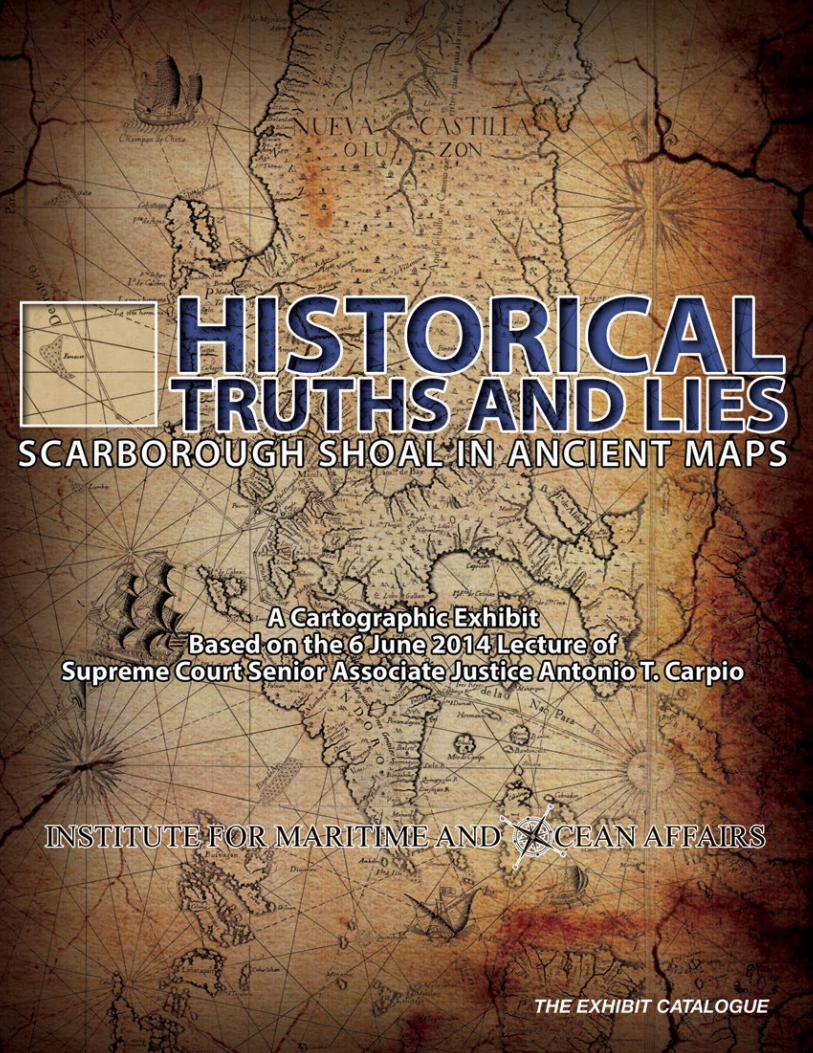
1H I S T O R I C A L T R U T H S A N D L I E S : A N E X H I B I T C ATA L O G U E

2 H I S T O R I C A L T R U T H S A N D L I E S : A N E X H I B I T C ATA L O G U E
MAP 1. “CARTAHYDROGRAPHICA
Y CHOROGRAPHICADE LAS YSLAS FILIPINAS”
Published in 1734 in Manila by the Jesuit Pedro Murillo Velarde, this is the oldest map that gives
a name to “Panacot” shoal. “Panacot” is the Tagalog word for threat or danger. This map names
two Filipinos, Francisco Suarez who drew the map and Nicolas dela Cruz Bagay who engraved
it. This map is considered the “mother of all Philippine maps.” This digital reproduction is from
the U.S. Library of Congress (Catalog No. 2013585226; Digital
ID g8060 ct003137).
Map 1 (also 29 and 60)
“Maps merely constitute information which varies in accuracy from case to case; of themselves, and by virtue solely of their existence, they cannot constitute a territorial title, that is, a document endowed by international law with intrinsic legal force for the purpose of establishing territorial rights.” Burkina Faso/Republic of Mali (1986 I.C.J. 554)
Thus, a state cannot enlarge its rights under international law by its own unilateral acts or domestic legislation. Yet, this is exactly what China did in 1947 when China drew its nine-dashed lines map in the South China Sea, claiming as basis historical facts.
3H I S T O R I C A L T R U T H S A N D L I E S : A N E X H I B I T C ATA L O G U E
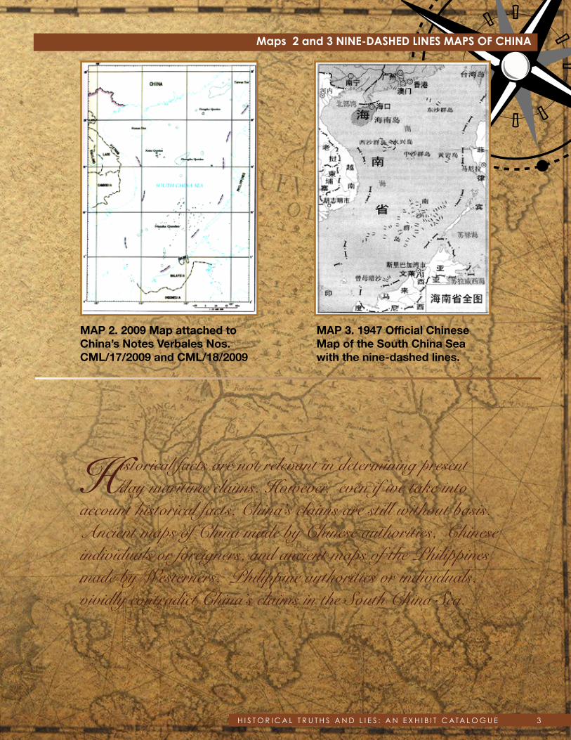
MAP 3. 1947 Official Chinese Map of the South China Sea with the nine-dashed lines.
MAP 2. 2009 Map attached to China’s Notes Verbales Nos. CML/17/2009 and CML/18/2009
Maps 2 and 3 NINE-DASHED LINES MAPS OF CHINA
Historical facts are not relevant in determining present day maritime claims. However, even if we take into
account historical facts, China’s claims are still without basis. Ancient maps of China made by Chinese authorities, Chinese individuals or foreigners, and ancient maps of the Philippines made by Westerners, Philippine authorities or individuals, vividly contradict China’s claims in the South China Sea.

4 H I S T O R I C A L T R U T H S A N D L I E S : A N E X H I B I T C ATA L O G U E
MAP 4. “HUA YI TU” or Map of China and the Barbarian Countries
Engraved in stone in Fuchang in 7 nian, i.e. 1136 A.D. during the Nan Song Dynasty. This map of China was published in 1903(?) in France from a rubbing of the stone engraving. The stone map is now in the Forest of Stone Steles Museum in Xi’an, China. The stone map shows Hainan Island as the southernmost territory of China. The annotations on the sides of the map are not part of the stone engraving. This digital reproduction is from the U.S. Library of Congress (Catalog No. 2002626771; Digital ID g7820 ct000284).
MAP 5. “DA MING HUN YI TU” or the Great Ming Dynasty Amalgamated Map
Published in 1389(?) during the Ming Dynasty, this map is painted in color on silk. The map shows Hainan Island as the southernmost territory of China. The original of the map is with the First Historical Archive of China in Beijing. This digital reproduction is from Wikimedia Commons, which sourced its copy from the library of the Hong Kong Baptist University. (http://geog.hkbu.edu.hk/geog1150/chinese/catalog/am31_map1.htm).
Map 4
Map 5
Since the start of the Song Dynasty in 960 AD until the end of the Qing Dynasty in 1912, or for almost a millennium, the
southernmost territory of China has always been Hainan Island based on all official and unofficial maps of China.
And as late as 1932, the Chinese Government in a Note Verbale to France reiterated to the world that the southernmost territory of China is Hainan Island.
5H I S T O R I C A L T R U T H S A N D L I E S : A N E X H I B I T C ATA L O G U E
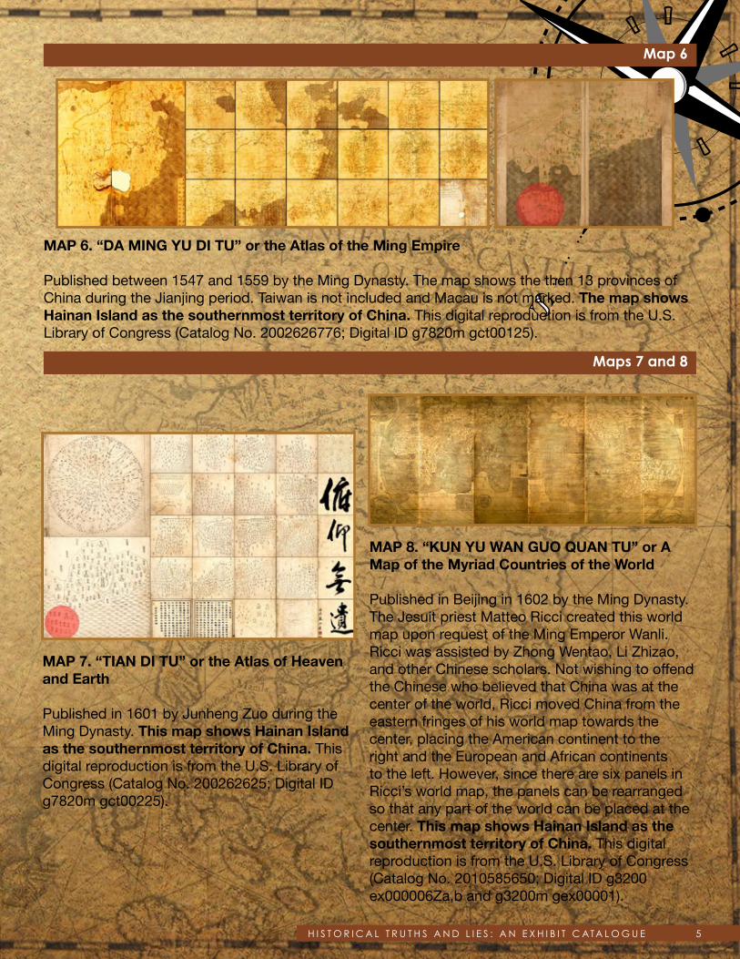
MAP 6. “DA MING YU DI TU” or the Atlas of the Ming Empire
Published between 1547 and 1559 by the Ming Dynasty. The map shows the then 13 provinces of China during the Jianjing period. Taiwan is not included and Macau is not marked. The map shows Hainan Island as the southernmost territory of China. This digital reproduction is from the U.S. Library of Congress (Catalog No. 2002626776; Digital ID g7820m gct00125).
Map 6
Maps 7 and 8
MAP 7. “TIAN DI TU” or the Atlas of Heaven and Earth
Published in 1601 by Junheng Zuo during the Ming Dynasty. This map shows Hainan Island as the southernmost territory of China. This digital reproduction is from the U.S. Library of Congress (Catalog No. 200262625; Digital ID g7820m gct00225).
MAP 8. “KUN YU WAN GUO QUAN TU” or A Map of the Myriad Countries of the World
Published in Beijing in 1602 by the Ming Dynasty. The Jesuit priest Matteo Ricci created this world map upon request of the Ming Emperor Wanli. Ricci was assisted by Zhong Wentao, Li Zhizao, and other Chinese scholars. Not wishing to offend the Chinese who believed that China was at the center of the world, Ricci moved China from the eastern fringes of his world map towards the center, placing the American continent to the right and the European and African continents to the left. However, since there are six panels in Ricci’s world map, the panels can be rearranged so that any part of the world can be placed at the center. This map shows Hainan Island as the southernmost territory of China. This digital reproduction is from the U.S. Library of Congress (Catalog No. 2010585650; Digital ID g3200 ex000006Za,b and g3200m gex00001).

6 H I S T O R I C A L T R U T H S A N D L I E S : A N E X H I B I T C ATA L O G U E
Map 11
Map 12
Maps 9 and 10
MAP 11. “DA QING WAN NIAN YI TONG DI LI QUAN TU” or the Complete Geographical Map of the Great Qing Dynasty
Published in China between 1814 and 1816 by Qianren Huang. This map shows Hainan Island as the southernmost territory of China. Revised edition based on the original map drawn by Huang Qianren in 1767. This digital reproduction is from the U.S. Library of Congress (Catalog No. gm71005060; Digital ID g7820 ct002256).
MAP 12. “GUANGDONG TONG SHENG SHUI DAO TU” or Map of the Waterways of Guangdong Province
Published sometime after 1815 by an unknown Chinese publisher. This map shows Hainan Island as the southernmost part of Guangdong province. This digital reproduction is from the U.S. Library of Congress (Catalog No. gm71002467; Digital ID g7823g ct003406).
MAP 9. “SELDEN MAP OF CHINA”
This map was bequeathed by John Selden to the Bodleian Library of the University of Oxford in 1659. Published sometime between 1606 and 1624 during the Ming Dynasty. The maker of the map is an unknown Chinese. The map shows China, South Asia, Southeast Asia, and East Asia. The South China Sea is conspicuously at the center of the map. The map shows China with Hainan as its southernmost territory. This digital reproduction is from the Bodleian Library of the University of Oxford (http://seldenmap.bodleian.ox.ac.uk/map).
MAP 10. “DA QING WAN NIAN YI TONG TIAN XIA QUAN TU” or The Great Qing Dynasty’sComplete Map of All Under Heaven
Published in China in 1811 by the Qing Emperor Jiaqing. This map shows Hainan Island as the southernmost territory of China. This digital reproduction is from the U.S. Library of Congress (Catalog No. gm71005018; Digital ID g3200 ct003403).

7H I S T O R I C A L T R U T H S A N D L I E S : A N E X H I B I T C ATA L O G U E
MAP 13. “GUANGDONG QUAN TU” or the Complete Map of Guangdong Province
Published in 1864 in Wuchang, China by Hubei Sheng and Guan Shu Ju. This map shows Hainan Island as the southernmost part of Guangdong province. This digital reproduction is from the U.S. Library of Congress (Catalog No. gm71005120; Digital ID g7823g ct003391).
MAP 14. “DA QING ER SHI SAN SHENG YU DI QUAN TU” or the Complete Map of the Twenty-Three Provinces of the Great Qing Dynasty
Published sometime after 1885 in China by the Qing Dynasty. This map shows Hainan Island as the southernmost territory of China. This digital reproduction is from the U.S. Library of Congress (Catalog No. gm71005068; Digital ID g7820 ct003427).
MAP 15. “GUANGDONG QUAN SHENG SHUI LU YU TU” or Map of the Waterways and Roads in Guangdong Province
Published in 1887(?) in China by Li Zhongpei. This map shows that Hainan Island is the southernmost part of Guangdong province. On the upper left side of the map, the annotations of Li Zhongpei state: “Qiongzhou (name of Hainan Island at that time) is far from the mainland, has a coastline of more than 1,400 li (unit of distance in Chinese), and is the territory (of China) that ships navigating to China will encounter when coming from Southeast Asia.” This digital reproduction is from the U.S. Library of Congress (Catalog No. gm71005159; Digital ID g7823g ct003392).
MAP 16. “HUANG CHAO ZHI SHENG YU DI QUAN TU” or the Qing Empire’s Complete Map of All Provinces
Published in 1896 in China by Peilan Li. Thismap shows Hainan Island as the southernmost territory of China. This digital reproduction is from the U.S. Library of Congress (Catalog No. gm71005083; Digital ID g7820 ct003428).
Map 15
Map 16
Maps 13 and 14

8 H I S T O R I C A L T R U T H S A N D L I E S : A N E X H I B I T C ATA L O G U E
MAP 17. “ZHONG HUA GUO CHI DI TU”
Published in 1929 in Beijing by Hebei Sheng and Gong Shang Ting. The map mentions the treaties signed by China and the harbors opened to foreign powers. This map shows Hainan Island as the southernmost territory of China. This digital reproduction is from the U.S. Library of Congress (Catalog No. 2007628129; Digital ID g7821f ct002301).
Maps 17
Scarborough Shoal is more than 500 NM from Hainan Island, at the other end of the South China Sea.

9H I S T O R I C A L T R U T H S A N D L I E S : A N E X H I B I T C ATA L O G U E
MAP 20. “CARTE DE L’EMPIRE DE LA CHINE, DE LA TARTARIE CHINOISE, ET DU ROYAUME DE CORÉE, AVEC LES ISLES DU JAPON”
Published in 1787 in Paris by Rigobert Bonne. This map shows L. de Haynan as the southernmost portion of China. This digital reproduction is from the private collection of Atty. Anne Marie Corominas of Manila and Cebu.
MAP 21. “CARTE DE L’EMPIRE CHINOIS ET DU JAPON” or A French Map of the ChineseEmpire together with Japan
Published in 1833 in Paris by Conrad Malte-Brun. This map shows Hainan Island as the southernmost territory of China. This digital reproduction is from Wikimedia Commons (http://en.wikipedia.org/wiki/File:L%27Empire_Chinois_et_du_Japon_%281833%29.jpg).
Maps 20 and 21
Maps 18 and 19
MAP 18. “CARTE EXACTE DE TOUTES LES PROVINCES, VILLES, BOURGS, VILLAGES ET RIVIERES DU VASTE ET PUISSANT EMPIRE DE LA CHINE” or An Accurate Map of All the Provinces, Cities, Towns, Villages and Rivers of the Vast and Powerful Chinese Empire
Published in 1700(?) in Leiden, Netherlands by Johannes Nieuhof who made the map before his death in 1672. The map shows Hainan Island as the southernmost territory of China. This digital reproduction is from the U.S. Library of Congress (Catalog No. 87691057; Digital ID g7810 ct002857).
MAP 19. “CARTE LA PLUS GENERALE ET QUI COMPREHEND LA CHINE, LA TARTARIE CHINOISE, ET LE THIBET” or A General Map that Includes China, Chinese Tartary and Tibet
Created in 1734 in Paris by Jean Baptiste Bourguignon D’Anville. D’Anville was then the Royal Cartographer of France and had access to the works of the Jesuit cartographers in China through his friend the French Jesuit Du Halde, who was a specialist on China. As the map itself states, the map was taken from surveys made by Jesuit missionaries from 1708-1716 upon instructions of the Emperor Kangxi of the Qing Dynasty. The map shows Hainan Island as the southernmost territory of China. This digital reproduction is from the National Library of Australia (Bib ID 2333624, Map Section at RM 3521).
10 H I S T O R I C A L T R U T H S A N D L I E S : A N E X H I B I T C ATA L O G U E
Maps 22 and 23
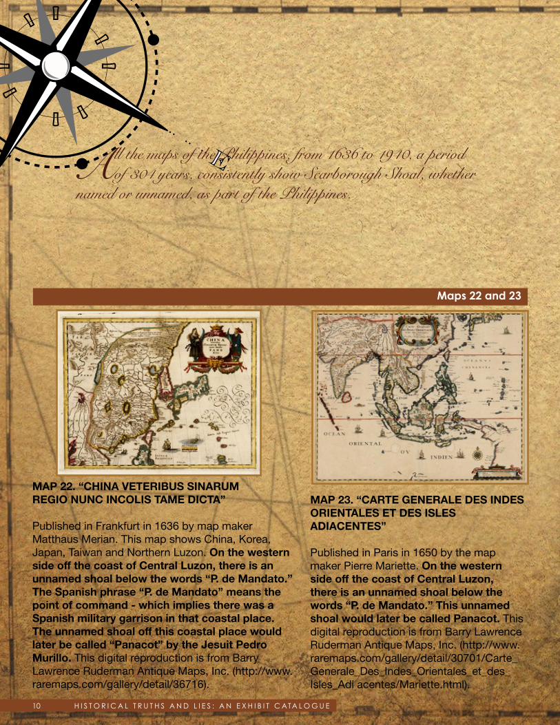
MAP 22. “CHINA VETERIBUS SINARUMREGIO NUNC INCOLIS TAME DICTA”
Published in Frankfurt in 1636 by map maker Matthaus Merian. This map shows China, Korea, Japan, Taiwan and Northern Luzon. On the western side off the coast of Central Luzon, there is an unnamed shoal below the words “P. de Mandato.” The Spanish phrase “P. de Mandato” means the point of command - which implies there was a Spanish military garrison in that coastal place. The unnamed shoal off this coastal place would later be called “Panacot” by the Jesuit Pedro Murillo. This digital reproduction is from Barry Lawrence Ruderman Antique Maps, Inc. (http://www.raremaps.com/gallery/detail/36716).
MAP 23. “CARTE GENERALE DES INDESORIENTALES ET DES ISLES ADIACENTES”
Published in Paris in 1650 by the map maker Pierre Mariette. On the western side off the coast of Central Luzon, there is an unnamed shoal below the words “P. de Mandato.” This unnamed shoal would later be called Panacot. This digital reproduction is from Barry Lawrence Ruderman Antique Maps, Inc. (http://www.raremaps.com/gallery/detail/30701/Carte_Generale_Des_Indes_Orientales_et_des_Isles_Adi acentes/Mariette.html).
All the maps of the Philippines, from 1636 to 1940, a period of 304 years, consistently show Scarborough Shoal, whether
named or unnamed, as part of the Philippines.
11H I S T O R I C A L T R U T H S A N D L I E S : A N E X H I B I T C ATA L O G U E
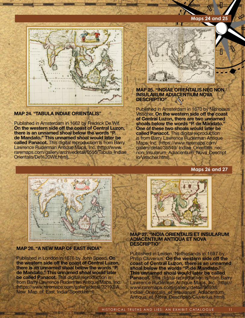
MAP 26. “A NEW MAP OF EAST INDIA”
Published in London in 1676 by John Speed. On the western side off the coast of Central Luzon, there is an unnamed shoal below the words “P. de Mandato.” This unnamed shoal would later be called Panacot. This digital reproduction is from Barry Lawrence Ruderman Antique Maps, Inc. (https://www.raremaps.com/gallery/detail/32192/A_New_Map_of_East_India/ Speed.html).
MAP 27. “INDIA ORIENTALIS ET INSULARUM ADIACENTIUM ANTIQUA ET NOVADESCRIPTIO”
Published in Leiden, Netherlands in 1697 by Philip Cluverius. On the western side off the coast of Central Luzon, there is an unnamed shoal below the words “P. de Mandato.” This unnamed shoal would later be called Panacot. This digital reproduction is from Barry Lawrence Ruderman Antique Maps, Inc. (http:// www.raremaps.com/gallery/detail/36938/ Indiae_Orientalis_et_Insularum_Adiacentum_Antiqua_et_Nova_Descriptio/Cluverius.html).
Maps 26 and 27
Maps 24 and 25
MAP 24. “TABULA INDIAE ORIENTALIS”
Published in Amsterdam in 1662 by Fredrick De Wit. On the western side off the coast of Central Luzon, there is an unnamed shoal below the words “P. de Mandato.” This unnamed shoal would later be called Panacot. This digital reproduction is from Barry Lawrence Ruderman Antique Maps, Inc. (http://www.raremaps.com/gallery/archivedetail/0555/Tabula_Indiae_Orientalis/De%20Wit.html).
MAP 25. “INDIAE ORIENTALIS NEC NONINSULARUM ADIACENTIUM NOVA DESCRIPTIO”
Published in Amsterdam in 1670 by Nicholaus Visscher. On the western side off the coast of Central Luzon, there are two unnamed shoals below the words “P. de Mandato.” One of these two shoals would later be called Panacot. This digital reproduction is from Barry Lawrence Ruderman Antique Maps, Inc. (https://www.raremaps.com/gallery/detail/35549/ Indiae_Orientalis_nec_non_Insularum_Adiacentium_Nova_Descript io/Visscher.html).
12 H I S T O R I C A L T R U T H S A N D L I E S : A N E X H I B I T C ATA L O G U E
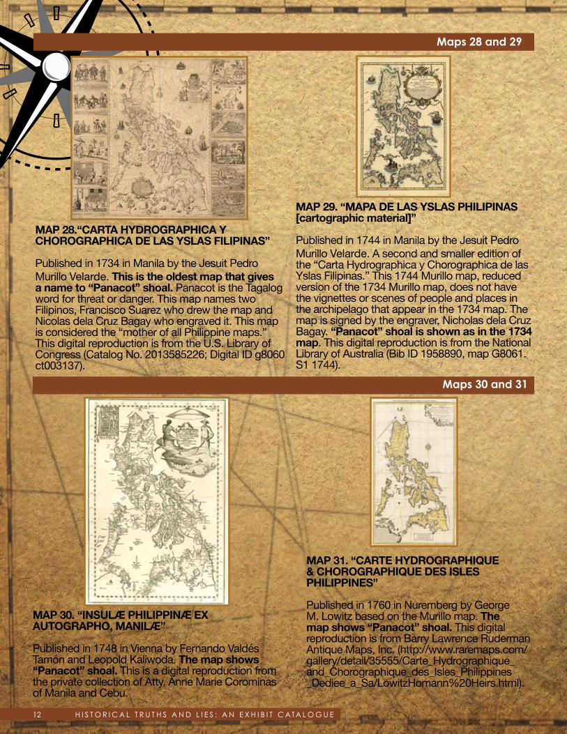
Maps 28 and 29
MAP 30. “INSULÆ PHILIPPINÆ EX AUTOGRAPHO, MANILÆ”
Published in 1748 in Vienna by Fernando Valdés Tamón and Leopold Kaliwoda. The map shows “Panacot” shoal. This is a digital reproduction from the private collection of Atty. Anne Marie Corominas of Manila and Cebu.
MAP 31. “CARTE HYDROGRAPHIQUE & CHOROGRAPHIQUE DES ISLES PHILIPPINES”
Published in 1760 in Nuremberg by George M. Lowitz based on the Murillo map. The map shows “Panacot” shoal. This digital reproduction is from Barry Lawrence Ruderman Antique Maps, Inc. (http://www.raremaps.com/gallery/detail/35555/Carte_Hydrographique_and_Chorographique_des_Isles_Philippines _Dediee_a_Sa/LowitzHomann%20Heirs.html).
MAP 28.“CARTA HYDROGRAPHICA Y CHOROGRAPHICA DE LAS YSLAS FILIPINAS”
Published in 1734 in Manila by the Jesuit Pedro Murillo Velarde. This is the oldest map that gives a name to “Panacot” shoal. Panacot is the Tagalog word for threat or danger. This map names two Filipinos, Francisco Suarez who drew the map and Nicolas dela Cruz Bagay who engraved it. This map is considered the “mother of all Philippine maps.” This digital reproduction is from the U.S. Library of Congress (Catalog No. 2013585226; Digital ID g8060 ct003137).
MAP 29. “MAPA DE LAS YSLAS PHILIPINAS[cartographic material]”
Published in 1744 in Manila by the Jesuit Pedro Murillo Velarde. A second and smaller edition of the “Carta Hydrographica y Chorographica de las Yslas Filipinas.” This 1744 Murillo map, reduced version of the 1734 Murillo map, does not have the vignettes or scenes of people and places in the archipelago that appear in the 1734 map. The map is signed by the engraver, Nicholas dela Cruz Bagay. “Panacot” shoal is shown as in the 1734 map. This digital reproduction is from the National Library of Australia (Bib ID 1958890, map G8061.S1 1744).
Maps 30 and 31

13H I S T O R I C A L T R U T H S A N D L I E S : A N E X H I B I T C ATA L O G U E
Maps 32 and 33
MAP 35. “A CHART OF THE CHINA SEA”
Published in 1775 in Paris by D’Apres de Mannevillette. The map shows “Scarboro” shoal. The British tea clipper Scarborough struck the rocks of the shoal on 12 September 1748, and so European cartographers named the shoal Scarborough. This digital reproduction is from the National Library of Australia (Bib ID 3770071, map- ra49-s32).
MAP 34. “EAST INDIES”
Published in 1770 in London by Thomas Kitchin, the then Royal Hydrographer. This map shows “Panacot” shoal. This digital reproduction is from the National Library of Australia (Bib ID 3620673, map-rm1424).
MAP 32. “A GENERAL MAP OF THE EAST INDIES AND THAT PART OF CHINA WHERE THE EUROPEANS HAVE ANY SETTLEMENTS OR COMMONLY ANY TRADE”
Published in 1761 in London by the map maker Thomas Kitchin. This map shows “Panacot” shoal. This digital reproduction is from Barry Lawrence Ruderman Antique Maps, Inc. (http://www.raremaps.com/gallery/detail/0176gh/A_General_Map_of_the_East_Indies_and_that_Part_of_China_where_the_Europeans/Kitchin.html).
MAP 33. “A NEW MAP OF THE PHILIPPINE ISLANDS, DRAWN FROM THE BEST AUTHORITIES”
Published in 1769 in London by Thomas Kitchin. This map shows “Panacot” shoal. This digital reproduction is from the private collection of Atty. Anne Marie Corominas of Manila and Cebu.
Map 34
Map 35

14 H I S T O R I C A L T R U T H S A N D L I E S : A N E X H I B I T C ATA L O G U E
Map 38
Map 39
Maps 36 and 37
MAP 38. “MAP OF THE PACIFIC OCEAN BETWEEN THE COAST OF CALIFORNIA AND MEXICO AND JAPAN, PHILIPPINES, AND THE COAST OF CHINA”
Published in 1784 with the watermark PVL (Pieter van Ley). This map shows a shoal named “B. Mansiloc.” This digital reproduction is from the U.S. Library of Congress (Catalog No. 91680984, Digital ID g9230 Ih000015).
MAP 39. “ISOLE FILIPPINE”
Published in 1785 in Venice by Antonio Zatta. This map is based on the Murillo map although there is no such acknowledgment in the map. “Panacot” shoal appears on this map as in the Murillo map. This digital reproduction is from Barry Lawrence Ruderman Antique Maps, Inc. (http://www.raremaps.com/gallery/detail/33827).
MAP 36. “A CHART OF THE CHINA SEA AND THE PHILIPPINE ISLANDS WITH THE ARCHIPELAGOS OF FELICIA AND SOLOO”
Published in 1778 in London by R. Sayer and J. Bennett. Interestingly, “Panacot or Marsingola Bank” is the name given to one feature and “Scarborough Shoal” is the name given to a nearby shoal, with the words “the Scarborough Sept. 12, 1748,” the date when the British tea clipper struck the shoal. This digital reproduction is from the National Library of Australia (Bib ID 3667413, map-ra52-s70).
MAP 37. “CARTE DE LA PARTIE ORIENTALE DES PHILIPPINES AND CARTE DE LA PARTIEOCCIDENTALE DES PHILIPPINES”
Published in 1781 in Paris by Gaitte, A.J. Two maps together forming a map of the Philippines, with upper left corner inset: Trombe Marine. Engraved by A.J. Gaitte and included in volume II of Le Gentil de la Galaisière’s voyage dans les Mers de L’Inde. The map shows B. de Masingolo. This is a digital reproduction from the private collection of Atty. Anne Marie Corominas of Manila and Cebu.

15H I S T O R I C A L T R U T H S A N D L I E S : A N E X H I B I T C ATA L O G U E
Maps 40 and 41
MAP 42. “MAPA DE LAS ISLAS FILIPINAS”
Published in 1790 in Madrid by Duque de Almodóvar. The map shows “Bco de Masingolo o’ Panacot”. This is a digital reproduction from the private collection of Atty. Anne Marie Corominas of Manila and Cebu.
MAP 43. 1792 CHART “PLANO DE LA NAVIGACION” is the route of the navigation taken by Alessandro Malaspina’s ship Sta. Lucia when Malaspina surveyed what is stated in the map as “Bajo Masinloc o Scarborough.”
Published in Madrid by the Direccion de Hidrografia from the surveys of the Malaspina Expedition. On 4 May 1792, the day he surveyed Bajo de Masinloc, Malaspina wrote in his Journal “on (this shoal) Spanish and foreign ships have been lost.” This digital reproduction is from the archives of the Museo Naval de Madrid, copied by the Philippine Embassy in Madrid.
Map 43
Map 42
MAP 40. “SECONDE PARTIE DE LA CARTED’ASIE” or Second Part of the Map of Asia
Published in 1786 in Paris by Jean Baptiste B. D’Anville as part of his Atlas de D’Anville. The map shows Sumatra, Java, Borneo, Moluccas, Philippines and Japan. The first part of the map of Asia is basically the 1734 China map of D’Anville. D’Anville’s Atlas was later re-printed by Robert Sayer, Laurie and Whittle and others. This map shows “Panacot” shoal. In the later reprinted maps of Sayer, and Laurie and Whittle, Panacot is called Scarborough shoal. This digital reproduction is from the National Library of Australia (Bib ID 3664337,Bib ID 1372672, map-ra 39).
MAP 41. “A NEW CHART OF THE INDIAN AND PACIFIC OCEANS BETWEEN THE CAPE OF GOOD HOPE, NEW HOLLAND AND JAPAN”
Published in 1787 in London by Robert Sayer. This map shows “Scarboro” shoal. This digital reproduction is from the National Library of Australia (Bib ID 3507852, map-rm-451).

16 H I S T O R I C A L T R U T H S A N D L I E S : A N E X H I B I T C ATA L O G U E
Maps 44 and 45
MAP 46. “CARTA GENERAL DELARCHIPIELAGO DE FILIPINAS”
Published in 1808 in Madrid by the Direccion de Hidrografia from the surveys of the Malaspina Expedition. The shoal is called “Bajo de Masingloc” but the map also adds “o Scarborough.” This digital reproduction is from the archives of the Museo Naval de Madrid, copied by the Philippine Embassy in Madrid.
MAP 47. “EAST INDIA ISLANDS ON MERCATOR’S PROJECTION”
Published between 1814 and 1832 in London by Thomas Kelly. The map shows “Scarboro” shoal. This digital reproduction is from the National Library of Australia (Bib ID 1493073, map-rm 2639).
Map 46
Map 47
MAP 44. “ASIA AND ITS ISLANDSACCORDING TO D’ANVILLE”
Published in 1794 in London by Robert Laurie and James Whittle. The map says that the delineations and discoveries made by Captain Cook are incorporated in the map. The map shows “Scarborough” shoal. This digital reproduction is from the National Library of Australia (Bib ID 2133866, map-rm 1865).
MAP 45. “A NEW CHART OF THE CHINASEA AND ITS SEVERAL ENTRANCES”
Published in 1802 in London by Robert Laurie and James Whittle. This map shows “Scarborough” shoal, with the words “Scarborough Sept. 12th, 1748” and “the Negroes Head.” This digital reproduction is from the National Library of Australia (Bib ID 3620691, map-rm 1425).

17H I S T O R I C A L T R U T H S A N D L I E S : A N E X H I B I T C ATA L O G U E
Maps 48 and 49
MAP 50. “CARTA ESFERICA DEL OCEANOINDIO”
Published in 1865 in Madrid by the Direccion de Hidrografia. The map shows “B. Masingloc.” This digital reproduction is from the National Library of Australia (Bib ID 122670, map-rm 2237).
MAP 48. “ASIA”
Published in 1818 in Philadelphia, USA by John Pinkerton. The map shows “Scarborough” shoal. This digital reproduction is from the U.S. Library of Congress (Catalog No. 2006636622, Digital ID g7400 ct1990).
MAP 49. “ISLAS FILIPINAS”
Published in 1852 in Madrid by D. Antonio Morata and D. Francisco Coello. This map shows “Bajo Masinloc.” This digital reproduction is from the National Library of Australia (Bib ID 3639193, map-rm 1608).
Maps 50 and 51
MAP 51. “PLANO DEL BAJO MASINGLOC”
Published in 1866 by E. Wilds, the Commander of the English warship Swallow, this map is entitled “Plano del Bajo Masingloc.” This digital reproduction is from the archives of the Museo Naval de Madrid, copied by the Philippine Embassy in Madrid.
18 H I S T O R I C A L T R U T H S A N D L I E S : A N E X H I B I T C ATA L O G U E
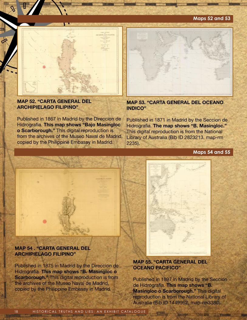
Maps 52 and 53
MAP 54 . “CARTA GENERAL DELARCHIPIELAGO FILIPINO”
Published in 1875 in Madrid by the Direccion deHidrografia. This map shows “B. Masingloc oScarborough.” This digital reproduction is from the archives of the Museo Naval de Madrid, copied by the Philippine Embassy in Madrid.
MAP 55. “CARTA GENERAL DELOCEANO PACIFICO”
Published in 1897 in Madrid by the Seccion de Hidrografia. This map shows “B. Masingloc o Scarborough.” This digital reproduction is from the National Library of Australia (Bib ID 1449962, map-rm3380).
MAP 53. “CARTA GENERAL DEL OCEANOINDICO”
Published in 1871 in Madrid by the Seccion deHidrografia. The map shows “B. Masingloc.” This digital reproduction is from the National Library of Australia (Bib ID 2823213, map-rm 2235).
Maps 54 and 55
MAP 52. “CARTA GENERAL DEL ARCHIPIELAGO FILIPINO”
Published in 1867 in Madrid by the Direccion de Hidrografia. This map shows “Bajo Masingloc o Scarborough.” This digital reproduction is from the archives of the Museo Naval de Madrid, copied by the Philippine Embassy in Madrid.

19H I S T O R I C A L T R U T H S A N D L I E S : A N E X H I B I T C ATA L O G U E
Maps 56 and 57
MAP 57. “MAP OF THE PHILIPPINEISLANDS”
Published in 1908 in Baltimore, MD U.S.A. by Caspar Hodgson. The map shows “Scarborough” shoal. This digital reproduction is from the U.S. Library of Congress (Catalog No. 2013590196, Digital ID g8060 ct003965).
MAP 56. “ISLAS FILIPINAS - MAPA GENERAL- OBSERVATORIO DE MANILA”
Published in 1899 in Washington, D.C. by the Jesuit Jose P. Algue and the U.S. Coast and Geodetic Survey. The map shows “Bo. Masinloc.” This digital reproduction is from the Atlas de Filipinas, Internet Archive, Ohio State University Library, (https://archive.org/stream/AtlasDeFilipinasColleccionDe30MapasTrabajadosPorDelineantes/AtlasDeFilipinas#page/n27/mode/1up).
From the 1960s to the 1980s, U.S. military warplanes, together with Philippine Air Force warplanes, used Scarborough Shoal as an impact
range when they practiced bombing runs. Neither China nor any other country protested these bombing practices by American and Philippine warplanes, despite worldwide prior Notices to Mariners, through the International Maritime Organization of the United Nations, to keep away from Scarborough Shoal during the bombing practices.

20 H I S T O R I C A L T R U T H S A N D L I E S : A N E X H I B I T C ATA L O G U E
MAP 58. “PHILIPPINE ISLANDS”
Published in 1933 and reissued in 1940 in Washington, D.C. by the U.S. Coast and Geodetic Survey. The map shows “Scarborough” shoal with depth soundings. This digital reproduction is from the U.S. Library of Congress (Catalog No. 2011592026; Digital ID g8061p ct003542).
Map 58
MAP 59.“CARTA HYDROGRAPHICA Y CHOROGRAPHICA DE LAS YSLAS FILIPINAS”
Published in 1734 in Manila by the Jesuit Pedro Murillo Velarde. This is the oldest map that gives a name to “Panacot” shoal. Panacot is the Tagalog word for threat or danger. This map names two Filipinos, Francisco Suarez who drew the map and Nicolas dela Cruz Bagay who engraved it. This map is considered the “mother of all Philippine maps.” This digital reproduction is from the U.S. Library of Congress (Catalog No. 2013585226; Digital ID g8060 ct003137).
Map 59
If the Philippines can bomb a shoal repeatedly over decades without any protest from neighboring states, it certainly must have sovereignty over such shoal.