Catalina Island Anchorage Policy Appendix G for … · The coordination and cooperation needed to...
15
Catalina Island Anchorage Policy Appendix G for Vessels Using the Federal Offshore Anchorages June 30, 2015 – Rev. 2015 G - 1 LA/LB Harbor Safety Committee POLICY FOR ASSIGNMENT AND OPERATION OF THE SANTA CATALINA ISLAND FEDERAL ANCHORAGES Avalon Harbor and Large Vessel Anchorage areas
Transcript of Catalina Island Anchorage Policy Appendix G for … · The coordination and cooperation needed to...
Catalina Island Anchorage Policy Appendix G for Vessels Using the Federal Offshore Anchorages
June 30, 2015 – Rev. 2015 G - 1
LA/LB Harbor Safety Committee
POLICY FOR ASSIGNMENT AND OPERATION
OF THE SANTA CATALINA ISLAND FEDERAL ANCHORAGES
Avalon Harbor and Large Vessel Anchorage areas

Catalina Island Anchorage Policy Appendix G for Vessels Using the Federal Offshore Anchorages
June 30, 2015 – Rev. 2015 G - 2
Federal Anchorages. The US Coast Guard established the Santa Catalina Island federal anchorages in 2005. The three anchorages provide better control and security over the increasing number of cruise ships visiting the island. The number and size of large passenger vessels visiting Santa Catalina Island along with visiting military vessels has increased and continued growth is expected. The coordination and cooperation needed to process multiple large vessels and large groups of passengers at one port has created a need for a policy ensuring safe operations.
Southeast Santa Catalina Island showing anchorages
Catalina Island Anchorage Policy Appendix G for Vessels Using the Federal Offshore Anchorages
June 30, 2015 – Rev. 2015 G - 3
Discussion: Historically, the number and size of large cruise ships visiting Santa Catalina Island has been somewhat manageable. Usually only one cruise ship visited at a time, with less than 3,000 passengers. Today, we see multiple cruise ships visiting with over 2,000 passengers onboard each vessel. These numbers do not include the crew which may also go ashore and the increasing tourism from the mainland. The Avalon Harbor area, immediately adjacent to the anchorages, can be extremely busy with private recreational vessels, cross channel fast ferries, visiting cruise ships and water taxi’s moving the thousands of visitors and passengers to the island. The cruise ships are unloading and loading thousands of people in the morning and again in the afternoon. Close coordination is necessary to ensure a safe visit by all. The passage of the recent Maritime Security Regulations has increased the visibility of cruise ship visitations to coastal areas along with other vessels. The federal anchorages have been established to assist in this regard. The presence of small craft in the vicinity of the cruise ships, the presence of aircraft flying nearby and the potential for other security issues drives the need to accurately coordinate the arrival and departure of visiting vessels. Anchorage Assignment: The three federal anchorages offshore of Santa Catalina Island “A”, “B” and “C”, will be assigned by the Vessel Traffic Service, Los Angeles/Long Beach. The anchorages will normally be assigned using the following prioritization in order of priority:
1. Length of time a particular cruise line and particular ship has been regularly calling at Avalon Harbor and has not broken this timing will be given the priority over which anchorage it is assigned. This will use actual arrival dates and number of calls per year. Reassignment priority will be given to these ships when weather or other schedule delays occur.
2. Secondly, the cruise line and individual ship who first submits a firm committed schedule for calling Avalon Harbor to the Vessel Traffic Service for coordination purposes. All proposed calls must be submitted by January 1 for the following year. Otherwise they will be on a first come first served basis. Committed schedules are demonstrated by having necessary contracts in place, agreements with the Avalon Harbor Master or others, and having sold passage on the vessel.
3. Lastly, an open anchorage is assigned on a first come, first served basis.
4. Any changes or modifications to the assigned anchorages are determined by the Vessel Traffic Service.

Catalina Island Anchorage Policy Appendix G for Vessels Using the Federal Offshore Anchorages
June 30, 2015 – Rev. 2015 G - 4
Santa Catalina Island Offshore Anchorages & Wind Patterns

Catalina Island Anchorage Policy Appendix G for Vessels Using the Federal Offshore Anchorages
June 30, 2015 – Rev. 2015 G - 5
Coordination: The Harbor Safety Committee, Outer Port Subcommittee (HSC, OPS) is the coordination entity for this policy. The Avalon Harbor Masters office is the coordinating entity for cruise lines and other vessels desiring to visit Santa Catalina Island and discharge passengers in Avalon Harbor. Local entities provide support to the visiting vessels and must plan long in advance in order to meet the needs of visiting vessels. The Avalon Harbor Master works with ships agents and cruise lines in advance of their arrivals to ensure safety and the transportation of passengers ashore. Vessel Traffic Service (VTS) will assign all federally established anchorages at Santa Catalina Island to the ships upon checking into the Vessel Traffic System. Large vessels must always use the designated anchorages as opposed to random anchoring offshore. The Vessel Traffic Service will observe and monitor the three federal anchorages at Santa Catalina Island. Particular attention will be paid on the arrival of large cruise ships and naval vessels. VTS and waterway users will be observant of any suspicious activity and report anything suspicious to the Captain of the Port and to the vessels and local authorities. Additionally, while the ship is at anchor, waterway users and the Avalon Harbor Master will provide additional observation and reporting of suspicious activities. Violations: Violators of these procedures will be reported to VTS. VTS will be the authority to order vessels to move from the anchorages. The Avalon Harbor Master is the authority for vessels operating inside of Avalon Harbor.
Pre-Arrival Planning
Multiple Ships Visiting Santa Catalina Island Anchorages: The following procedures are designed to insure the safe movement of personnel and passengers to and from multiple cruise ships and other vessels anchored offshore of Avalon Harbor. The port presently is receiving multiple cruise ships and military vessels and each has different needs due to the port layout and vessel traffic. Coordination must be maintained between the cruise ships, water taxi’s & tenders, cross-channel ferries and recreational vessels. Therefore, the below listed list provides guidance on certain items that should assist in the coordination. Cruise Vessels: Cruise vessels should ensure that the following information is passed to all concerned parties including the Coast Guard, Vessel Traffic Service and Avalon Harbor Master no later than 3 days in advance of the vessels' arrival.
1. General Info: Vessel names, lengths, number of passengers and crew 2. Arrival Schedule: Anchorage time and first water taxi arrival or first ships lighter
departs for Avalon Harbor 3. Order of Events: Timeline of ship movement events; passenger disembarkation and
embarkation and sailing time.
The Avalon Harbor Security Plan holder should meet with the vessels' Safety and Security Officer, prior to the commencement of passenger ferrying operations, to discuss all pertinent

Catalina Island Anchorage Policy Appendix G for Vessels Using the Federal Offshore Anchorages
June 30, 2015 – Rev. 2015 G - 6
information including terminal and vessel security, tendering operations, passenger safety and communications. A Declaration of Security (DOS) should be maintained for all operations.
Safe Operating Practices For Cruise Ship Tendering Operations The purpose of this section is to ensure the cruise ships, large visiting vessels and commercial waterway users know the standard operating procedures and are able to coordinate with arriving vessels. This section is also intended to familiarize the Masters and vessel operators to the local weather related hazards of Avalon Harbor and the near offshore area of Santa Catalina Island. The procedures in this document must be reviewed and a briefing should take place before arrival to Santa Catalina Island anchorage by visiting ships and by harbor support operations personnel. Specifically, briefings should discuss the following:
1. The restricted nature of Avalon Harbor. Tendering vessels should not congregate inside the harbor but wait outside the breakwater until there is dock space. Having too many vessels inside the harbor creates a situation where vessels cannot maneuver safely.
2. Using only a small number of tendering vessels. The Avalon Harbor Master recommends
that no more than four tenders be used per cruise ship to alleviate harbor congestion. If there is a need for more tenders, the cruise ship shall seek approval from the Avalon Harbor Master. Experience has shown that if more tenders are used, there may be insufficient space to safely dock.
3. Radio communications procedures should be reviewed. All tender vessels should be able to communicate in English on channel 9 and channel 16 marine VHF. Channel 9 should be used for coordinating with other tenders and channel 16 should be used for calling and emergencies. All radios operating in the near vicinity of Avalon Harbor should be in the low power mode.
4. Safe handling of the cruise ship tenders shall be reviewed. All ship tenders shall proceed through Avalon Harbor at a speed slow enough that it does not create a wake.
Anchorages and Standards of Care: The US Coast Guard established the anchorage locations for visiting vessels. The below listed offshore anchorages will be assigned by VTS upon checking into the system.
Anchorage A Anchorage B Anchorage CCatalina
Anchorages 33° 20' 59.0" N
118° 18' 56.2" W 33° 20' 38.3" N
118° 18' 35.8" W 33° 21' 21.0" N
118° 19' 16.7" W Depth of Water Anchorage A: 30-40 fathoms Anchorage B: 40-45 fathoms Anchorage C: 35-40 fathoms Anchorages have sandy bottom conditions.

Catalina Island Anchorage Policy Appendix G for Vessels Using the Federal Offshore Anchorages
June 30, 2015 – Rev. 2015 G - 7
The Harbor Safety Plan also contains the standards of care for vessels in anchorages. Vessel bridge management teams should follow these Standards of Care and Good Marine Practices while at anchor.
1. Keep a 24–hour bridge watch by an English-speaking licensed deck officer monitoring VHF–FM Channel 16.
2. Check frequently to assure the vessel is not dragging anchor.
3. Determine accurate wind speed by contacting either Avalon Harbor Master or the
National Weather Service. When winds exceed 40 knots, put your propulsion plant on standby ready to bring on line on short notice, and make another anchor ready to let go.
4. Provide 15–minute advance notice to VTS (outside anchorages) before heaving anchor to
get underway.
Santa Catalina Island: The island is 18 miles S of Point Fermin, is 18.5 miles long in a SE direction and has a greatest width of 7 miles. The island is privately owned. The island is almost divided by a deep N cut about 6 miles from the West end. The cut forms coves less than 0.5 mile apart at their heads, and because the isthmus separating these coves is low, the island appears as two from a few miles off. Rugged and mountainous, the island has steep, precipitous shores intersected occasionally by deep gulches and valleys, and is covered with a thick growth and some scrub oak. The highest peak, 2,125 feet, is near the middle of the East part of the island. Much of the North shore is free from kelp, but the South side in general has a narrow fringe of kelp close to the beach. The island rises abruptly from deepwater, the 30-fathom curve being close inshore. Most of the dangers in the approaches to the island are inside the kelp. Lights are shown from a pole with a red and white diamond-shaped daymark on the S end, Long Point (East side), and West End (NW point) of the island. Ribbon Rock, on the West side of Santa Catalina Island, 2.9 miles SE of West End, shows as a dark vertical rock wall with a gigantic ribbon of quartz veining that is visible for many miles. Farnsworth Bank, 9.2 miles SSE of West End and 1.6 miles offshore, has a least known depth of 9 fathoms over it. Shelter from Santa Ana winds can be had by anchoring in the bight near the Palisades on the South side of the island, 2 to 3 miles NW of the Southern extremity. COLREGS Demarcation Lines: The 72 COLREGS apply to the harbors on Santa Catalina Island. NOAA Chart 18757 applies to the operations in this procedure. Avalon Bay: Avalon Bay is on the North shore of Santa Catalina Island, 2.5 miles from its SE extremity is entered between Casino Point, breakwater on the North and the breakwater

Catalina Island Anchorage Policy Appendix G for Vessels Using the Federal Offshore Anchorages
June 30, 2015 – Rev. 2015 G - 8
extending from Cabrillo Peninsula, on the South. The breakwaters are marked by lights on their seaward ends. The small bay has depths of 2 to 13 fathoms; a depth of 20 fathoms is immediately outside the points of the bay. The Avalon Harbor Master reports that shelter is good during SW, NW, and SE weather if the wind does not exceed 20 knots. The breakwater provides limited protection in the NW and SE ends of the harbor during NE Santa Ana winds that occasionally blow during the fall and winter.
Avalon Harbor A large white circular building, brilliantly illuminated for about half the night during summer, is on Casino Point. Avalon is an incorporated city and part of Los Angeles County. Avalon is an extensive resort and the principal settlement of the island. Daily cross channel ferries and helicopter service is maintained year round to San Pedro, Long Beach, Newport Beach, Marina Del Rey, and Dana Point. A road along the beach extends some distance on each side of the cove, and at night the lights along this road are conspicuous from San Pedro Channel. The bay is extremely popular as a yacht haven and vacation resort during the summer. Vessel Communications: The Avalon Harbor Master has designated the channel and frequency in which the Vessel Traffic Coordinators will communicate with the water taxi operators and/or
Catalina Island Anchorage Policy Appendix G for Vessels Using the Federal Offshore Anchorages
June 30, 2015 – Rev. 2015 G - 9
commercial traffic and the cruise ships. Water taxi or tender call signs should be agreed upon prior to commencing operations.
Island Enterprise’s Avalon Water Taxi terminal monitors channel 16, 7 and 9 VHF. They are able to communicate with the Coast Guard, visiting vessels and the water taxi’s.
Visiting passenger vessels in the designated anchorages must monitor channels 13, 14
and 16 VHF and use channel 9 for coordination with the local harbor water taxi’s or tenders.
Water taxis and vessel tenders monitor and use channel 9 VHF. The Avalon Harbor Master monitors channels 16 and 12 VHF (24 hours).
Baywatch Avalon paramedics monitor channel 16 VHF daytime and can be reached via the Avalon Emergency Services Dispatcher at (310) 510-0174 or through the Avalon Harbor Master.
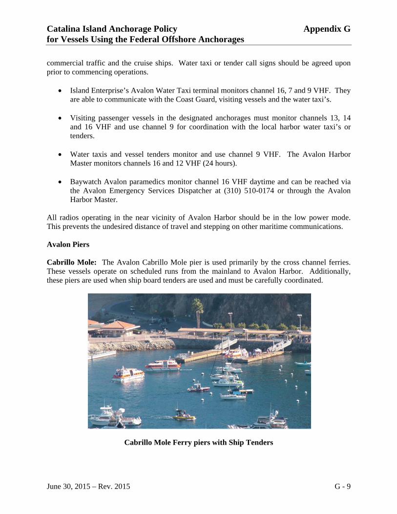
All radios operating in the near vicinity of Avalon Harbor should be in the low power mode. This prevents the undesired distance of travel and stepping on other maritime communications. Avalon Piers Cabrillo Mole: The Avalon Cabrillo Mole pier is used primarily by the cross channel ferries. These vessels operate on scheduled runs from the mainland to Avalon Harbor. Additionally, these piers are used when ship board tenders are used and must be carefully coordinated.
Cabrillo Mole Ferry piers with Ship Tenders

Catalina Island Anchorage Policy Appendix G for Vessels Using the Federal Offshore Anchorages
June 30, 2015 – Rev. 2015 G - 10
The cross channel ferries have water jet propulsion systems and produce significant currents during mooring and unmooring. There are three, 100-foot floating docks, with reported depths of 30 feet alongside, on the East side of the Cabrillo Mole (Cabrillo Peninsula). These docks are shared with all commercial waterway users and are controlled by the Avalon Harbor Master. Avalon Pleasure Pier: In the center of the Harbor is the Avalon Pleasure Pier with various loading floats, concessions, equipment rental firms are in the South part of Avalon Bay. In the summer months, May 1-October 15, an extension is added onto the pier providing substantially more space for water taxi and harbor tour boats (see below). Harbor Moorings: Yachts and other small craft moor to buoys in the bay; there are no alongside berths. The mooring buoys in the bay are privately owned.
Summer Floating Dock Operations from the end of Avalon Pier

Catalina Island Anchorage Policy Appendix G for Vessels Using the Federal Offshore Anchorages
June 30, 2015 – Rev. 2015 G - 11
During the winter periods, October 16-April 30 the floating pier on the end of the harbor dock is removed and shorter piers are used which lay alongside the main Avalon Pleasure Pier (See below).
Winter Floating Dock Operations from the side of Avalon Pier Avalon Harbor Traffic During the visit by cruise ships and other large vessels, smaller traffic supporting the ships along with cross channel ferries and visiting recreational vessels create a heavy traffic area in the harbor. The water taxis and ship tenders must ensure traffic can flow. There is more room outside the harbor than inside the breakwater and tenders should not crowd the harbor while others are debarking passengers. Tenders should slow their pace or remain outside the harbor until a berthing area is clear. Vessel and Terminal Security Either a Vessel Security Officer or representative and a Terminal Security Officer Representative shall always be present at pier side during the full duration of a cruise ship visit where passengers are being handled. These two officers are required to meet to ensure that their

Catalina Island Anchorage Policy Appendix G for Vessels Using the Federal Offshore Anchorages
June 30, 2015 – Rev. 2015 G - 12
security plan objectives are met and to ensure that security measures are not being breached. For example, the tender boarding area is a designated "RESTRICTED AREA" with access limited to authorized personnel using temporary barriers. Shipboard Crewing Requirements All cruise ships must be manned, while underway and at anchor, according to their SOLAS Safe Manning Document. This is to insure that sufficient crew is available to respond to unforeseen emergencies while passengers are aboard, such as a fire, dragging anchor or a security incident. Avalon Harbormaster The Avalon Harbor Master, located on the pleasure pier, offers 24 hour service year round and can be reached on VHF-FM channel 12 and 16 or call (310) 510-0535. Water Taxi’s Island Enterprises, Avalon Water Taxis and operating ships tenders can be reached on VHF-FM channel 9. Avalon Water Taxis can also be reached at 877-510-2888. Emergency Services Emergency medical services are available at Avalon. Baywatch Avalon paramedics should be contacted through the Avalon Sheriffs Dispatch Center by calling 310 510-0174, contacting the Coast Guard or the Avalon Harbor Master at Avalon on VHF-FM channel 16, 24 hours a day. Weather General weather conditions:
Prevailing year round NW winds @ 10-15 knots Summer months SE winds @ 7-10 knots, 6-10 AM Fog bank, east of island October-January NE winds @ 10-40 knots Santa Ana warming trend conditions 1-2 times/year, exceeds 5 knots
General Sea Conditions:
Wind waves 1-2 foot average Swell 1-3 foot average
Weather information for Avalon is broadcast by NOAA weather radio channel 1.

Catalina Island Anchorage Policy Appendix G for Vessels Using the Federal Offshore Anchorages
June 30, 2015 – Rev. 2015 G - 13
Wind The prevailing winds are W and NW and blow nearly every day, especially in the afternoon. Strong SE winds occur in the winter, and at times the sea is too rough for several days to permit the passage of small vessels. In the summer the winds in the channel are wholly different from those outside the islands and off the coast to the NW. Under the North shore, which is protected by the bold range of the Santa Ynez Mountains, the West winds do not reach far East of Point Conception with much strength but are felt towards the islands, a strong NW wind and heavy swell coming in from the open ocean. The climate in the Santa Barbara Channel, because of this blocking of the winds, is much milder than to the North along the coast. However, during NW weather boats crossing the channel from the mainland usually encounter heavier seas as the islands are approached. The belt of rough seas, locally known as Windy Lane, lies along the North shores of the islands and is about 6 miles (11 km) wide. This sea condition is the opposite to that experienced in the crossing from Los Angeles-Long Beach to Santa Catalina Island. These W winds usually begin about 1000 and grow progressively stronger until sundown. During heavy NW weather strong squally winds draw down the canyons between Point Conception and Capitan and pass directly offshore, causing a severe choppy sea. Heavy NW gales are often encountered off Point Conception on coming through Santa Barbara Channel, and great changes of climatic and meteorological conditions are experienced; the transition is often remarkably sudden and well defined. In the fall and winter, stiff northeasters are occasionally experienced at and near the E end of the channel. They come up without warning, usually at night in clear dry weather, and when the barometer is either high or rising rapidly. At such times small boats should be prepared to seek shelter at a moment’s notice. During the summer heavy fogs are a common occurrence in the Santa Barbara Channel and envelop the main shore, channel, and islands. Sometimes the mainland and channel are clear while the islands alone are hidden. At other times all are clear during the day, but wrapped in dense wet fog nights and mornings. This condition, the fog lying offshore during the day and enveloping the land at night, is characteristic of the whole southern California coast. The fogs occur mostly during calm weather and light winds, and are generally dissipated by the strong NW winds. Current Currents in Santa Barbara Channel are variable, depending to a great extent upon the wind. It appears that a weak non-tidal flow sets East in the spring and summer, and West in autumn and winter. It has been observed that a strong inshore set prevails on a rising tide in the deep waters of Hueneme Canyon. In general, there are conflicting currents, at times quite strong, around the slopes of the submarine valleys both here and off Point Mugu.
Catalina Island Anchorage Policy Appendix G for Vessels Using the Federal Offshore Anchorages
June 30, 2015 – Rev. 2015 G - 14
The tidal current sets along the N shore of Santa Barbara Channel with velocities of 0.5 to 1 knot. In heavy NW weather, the current and heavy swells make into the South side of the West entrance to the channel and along the North shore of San Miguel Island. The currents in the vicinity of the Channel Islands frequently follow the direction of the wind, with eddies under the lee of the islands and projecting points. Tidal currents of about 1 knot set through the passages between the islands. COMMENTS OR QUESTIONS Persons with comments or questions regarding the procedures for the Santa Catalina Island federal anchorages should contact any of the below persons: US Coast Guard: 310 521-3860 Waterways Management Vessel Traffic Service: 310 832-6411 Glossary COLREGS Collision Regulations DOS Declaration of Security HSC, OPS Harbor Safety Committee, Outer Port Subcommittee LA/LB Los Angeles/Long Beach FBI Federal Bureau of Investigations NOAA National Oceanic and Atmospheric Administration SOLAS Safety of Live at Sea (International Ship Safety Regulations) VHF-FM Very High Frequency-Frequency Modulated VTS Vessel Traffic Service

Catalina Island Anchorage Policy Appendix G for Vessels Using the Federal Offshore Anchorages
June 30, 2015 – Rev. 2015 G - 15
PORT COMMUNICATIONS PLAN
Vessel Name: Facility Name:
Call Sign: Phone Number:
Official Number:
Location: Catalina Island Anchorage____ Date:
Organization
Phone Number/Radio
Channel/Call Sign .
Type
Contact Name
Avalon Harbor Master/ Avalon
Mr. Brian Bray VHF Channel l6 & 12 +1 310 510-0535
Vessel Traffic Service Watch Stander VHF Channel 14 +1 310 832-64ll
Coast Guard Sector LAILB Watch Stander VHF Channel l6 +1 310 521-3801
Sheriff Department Dispatcher 310 510-0174
Customs & Immigration Office
Dispatcher +I 800 232-5378
FBI Duty Officer +1 562 432-6951 CATALINA CLASSIC CRUISES Ship to Shore Transportation
Capt. Ryan Palmer Mr. Chuck Dobbins Mr. Joe Caliva
1 562 335-3999 24 hrs. 1 415 265-5858 24 hrs. 1 310 560-8353
Other:
Communications Schedules and Special Procedures: