Casper Bluff - Galena Cabins
16
Owned and Managed by: Self Guided Tour Casper Bluff Land & Water Reserve Mission: To protect the natural heritage, spectacular scenery, and agricultural character of Jo Daviess County, Illinois, and the surrounding area
Transcript of Casper Bluff - Galena Cabins
Owned and Managed by:
Self Guided Tour
Casper Bluff Land & Water
Reserve
Mission: To protect the natural heritage,
spectacular scenery, and agricultural character of Jo Daviess County, Illinois,
and the surrounding area
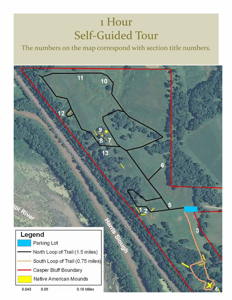
1 Hour Self-Guided Tour
The numbers on the map correspond with section title numbers.
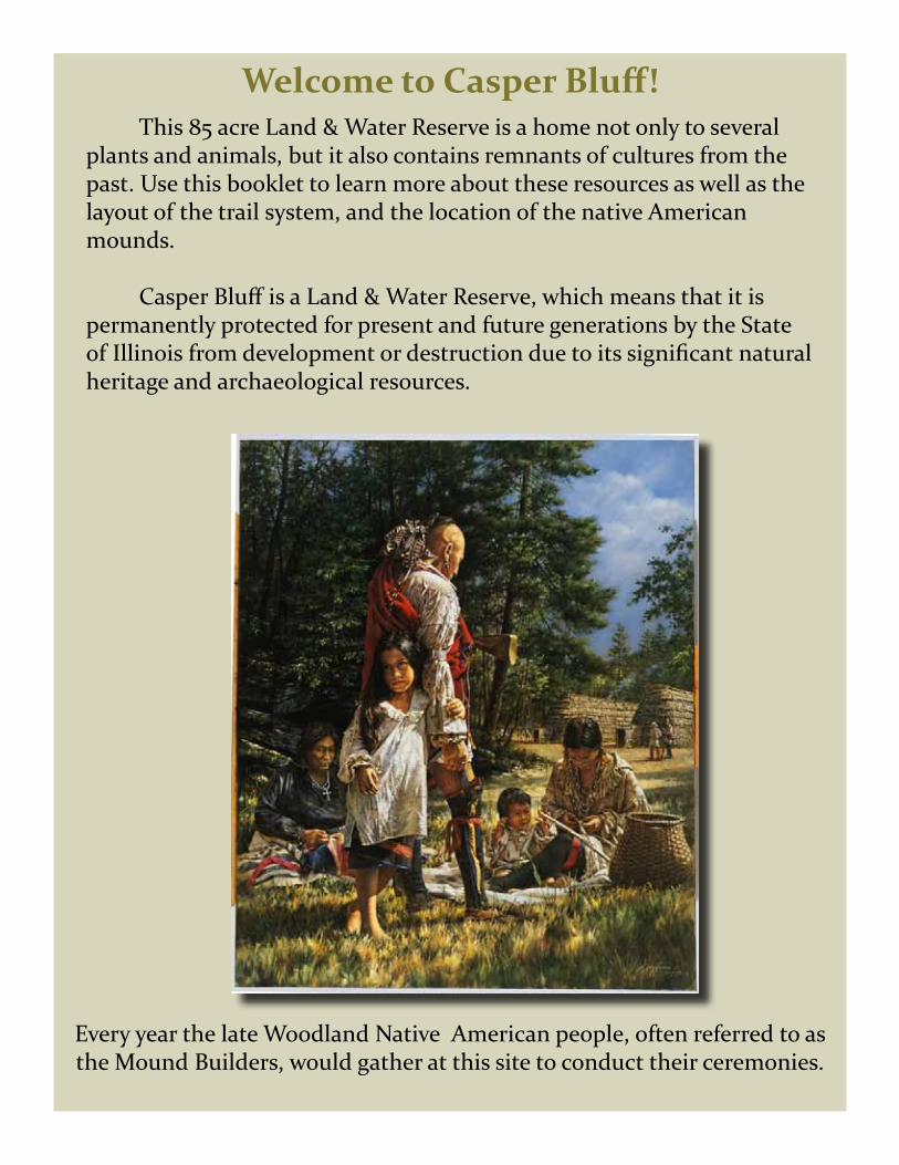
Welcome to Casper Bluff! This 85 acre Land & Water Reserve is a home not only to several plants and animals, but it also contains remnants of cultures from the past. Use this booklet to learn more about these resources as well as the layout of the trail system, and the location of the native American mounds.
Casper Bluff is a Land & Water Reserve, which means that it is permanently protected for present and future generations by the State of Illinois from development or destruction due to its significant natural heritage and archaeological resources.
Every year the late Woodland Native American people, often referred to as the Mound Builders, would gather at this site to conduct their ceremonies.

Facing the river you are looking west-southwest towards Iowa. In the river valley there are backwater sloughs and wetlands among the wooded islands. The main channel is closer to the Iowa side along this stretch of the river. The lock and dam system has transformed the Mississippi from a wild free-flowing river to a series of pools. These pools form watery steps from St. Louis to Minneapolis. The section of the river seen here is part of pool 12 or the section of the river north of Lock and Dam 12 at Bellevue, Iowa. The lock and dam system maintains the navigation channels for barges to transport products up and down the river. To do this, the water level on average is higher than it would be without the locks and dams. As a consequence, the vegetation within the river and much of the former floodplain has been irrevocably altered. Tree species from the diverse bottomland forests that once occurred in the floodplain have been lost and replaced by just a few species that can tolerate the much wetter soil conditions. Silver maple and cottonwood are the most common floodplain species now.
1 River Overlook
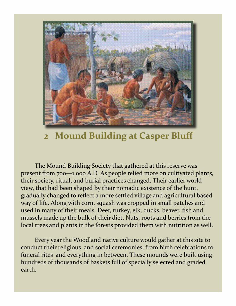
The Mound Building Society that gathered at this reserve waspresent from 700—1,000 A.D. As people relied more on cultivated plants, their society, ritual, and burial practices changed. Their earlier world view, that had been shaped by their nomadic existence of the hunt, gradually changed to reflect a more settled village and agricultural based way of life. Along with corn, squash was cropped in small patches and used in many of their meals. Deer, turkey, elk, ducks, beaver, fish and mussels made up the bulk of their diet. Nuts, roots and berries from the local trees and plants in the forests provided them with nutrition as well.
Every year the Woodland native culture would gather at this site to conduct their religious and social ceremonies, from birth celebrations to funeral rites and everything in between. These mounds were built using hundreds of thousands of baskets full of specially selected and graded earth.
2 Mound Building at Casper Bluff

Three types of mounds are found at Casper Bluff: Linear, Conical, and an Effigy Mound. An effigy mound is a raised pile of earth built in the shape of an animal during the Late Woodland Period 700-1,000 A.D. Linear and conical mounds were used for burials, boundaries and ceremonies. The combination of the effigy mound, the numerous linear and conical mounds, and the lack of any signs of permanent settlement, suggest that this was a sacred site, visited for rituals and special ceremonies but not continuously occupied. The people that used this site probably inhabited the valleys nearby.
Conical MoundLinear Mound
Effigy (Animal Shaped) Mound
Bear Thunderbird
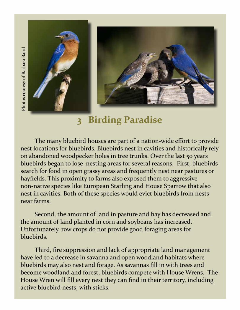
3 Birding Paradise
The many bluebird houses are part of a nation-wide effort to provide nest locations for bluebirds. Bluebirds nest in cavities and historically rely on abandoned woodpecker holes in tree trunks. Over the last 50 years bluebirds began to lose nesting areas for several reasons. First, bluebirds search for food in open grassy areas and frequently nest near pastures or hayfields. This proximity to farms also exposed them to aggressive non-native species like European Starling and House Sparrow that also nest in cavities. Both of these species would evict bluebirds from nests near farms.
Second, the amount of land in pasture and hay has decreased and the amount of land planted in corn and soybeans has increased. Unfortunately, row crops do not provide good foraging areas for bluebirds.
Third, fire suppression and lack of appropriate land management have led to a decrease in savanna and open woodland habitats where bluebirds may also nest and forage. As savannas fill in with trees and become woodland and forest, bluebirds compete with House Wrens. The House Wren will fill every nest they can find in their territory, including active bluebird nests, with sticks.
Phot
os c
oute
sy o
f Bar
bara
Bai
rd

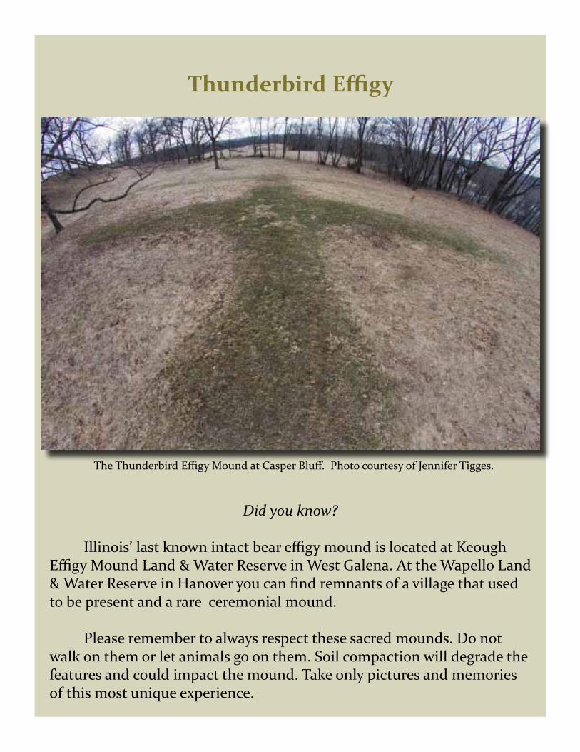
4 Thunderbird
This Thunderbird effigy mound is the prized feature at Casper Bluff. It is the only known intact Thunderbird effigy mound
remaining in the state of Illinois.
Native Americans believed the world was composed of three planes of existence. The upper world of air is the realm of winged creatures and is ruled by the Thunderbirds. The middle world is Earth and is the realm of humans and terrestrial animals. The lower world of water is the realm of bears, snakes, fish, and frogs. It is ruled by the Great Horned Serpent or the Underwater Panther.
Thunderbird Effigy
The Thunderbird Effigy Mound at Casper Bluff. Photo courtesy of Jennifer Tigges.
Did you know?
Illinois’ last known intact bear effigy mound is located at Keough Effigy Mound Land & Water Reserve in West Galena. At the Wapello Land & Water Reserve in Hanover you can find remnants of a village that used to be present and a rare ceremonial mound.
Please remember to always respect these sacred mounds. Do not walk on them or let animals go on them. Soil compaction will degrade the features and could impact the mound. Take only pictures and memories of this most unique experience.
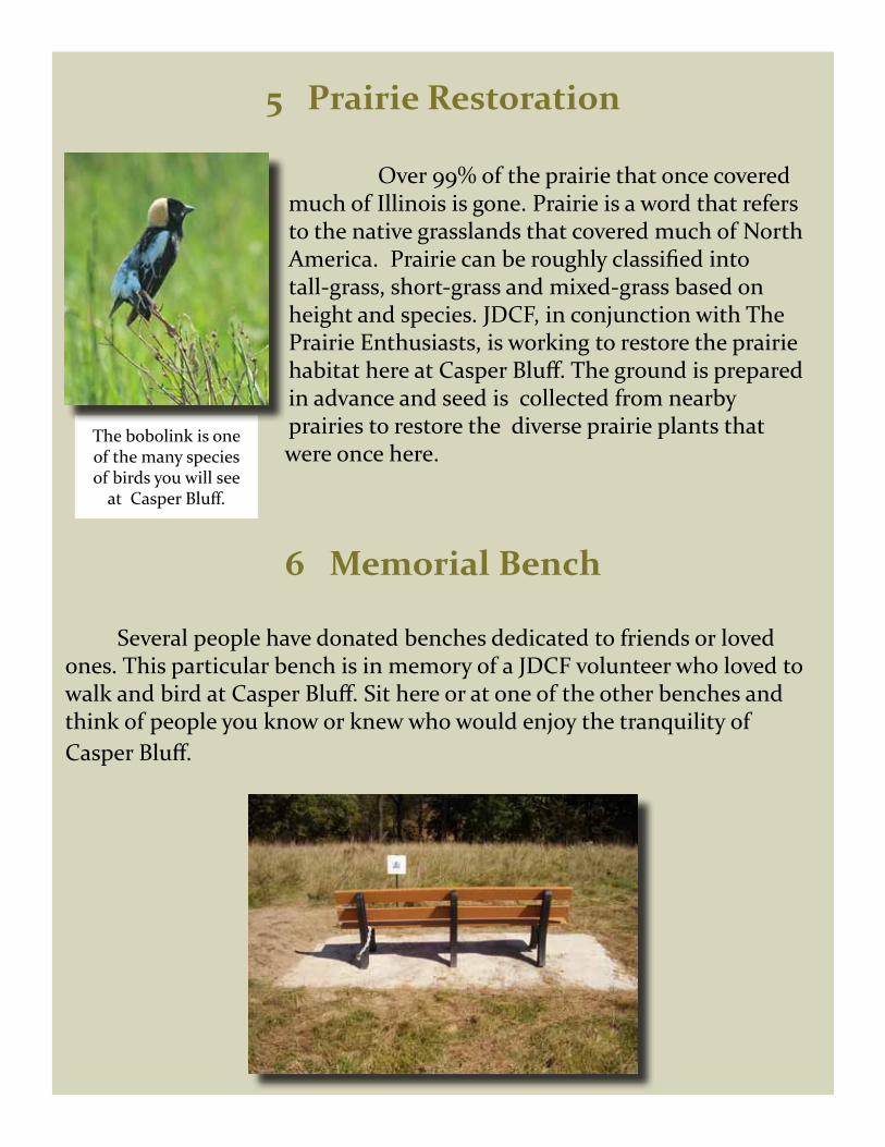
5 Prairie Restoration
Over 99% of the prairie that once covered much of Illinois is gone. Prairie is a word that refers to the native grasslands that covered much of North America. Prairie can be roughly classified into tall-grass, short-grass and mixed-grass based on height and species. JDCF, in conjunction with The Prairie Enthusiasts, is working to restore the prairie habitat here at Casper Bluff. The ground is prepared in advance and seed is collected from nearby prairies to restore the diverse prairie plants that
were once here.
6 Memorial Bench
Several people have donated benches dedicated to friends or loved ones. This particular bench is in memory of a JDCF volunteer who loved to walk and bird at Casper Bluff. Sit here or at one of the other benches and think of people you know or knew who would enjoy the tranquility of Casper Bluff.
The bobolink is one of the many species of birds you will see
at Casper Bluff.

This area was part of a farmstead that once included a house, barn, and windmill. You can see the date “1915”on the cement base around the pump at the well site. Most likely, settlers were here before that date but perhaps not as permanent resident farmers because this ridge-top location is not especially productive farm land. Records indicate this farm was abandoned in the 1930’s.
The origin and use of this large circular depression is likely related to the mound-building culture. It may have been a large structure, such as a sweat lodge, ring hut, or a building for ceremonies and gatherings. such as is pictured above. This site could also have been a borrow pit where they
“borrowed “ soil to make some of the other mounds. No one will ever truly know, but the central location along this section of the bluffs suggests that an important structure at this location is more likely than a borrow pit although it could have served both purposes.
8 Elliptical Pit
7 Old Farm Homestead

Along the river bluff you can see an oak savanna. Savanna can be thought of as part forest and part prairie. The trees are widely spaced allowing considerable sunlight to reach the ground level plants. Savanna habitats are usually maintained by fire and therefore the dominant trees are those that can tolerate fire such as oaks. In the absence of fire, woody shrubs invade the understory and fire sensitive tree species fill in the gaps between the savanna trees. Eventually the savanna becomes a closed canopy woodland or forest with very little space between the trees for
light to reach the ground. Most species of oaks need abundant sunlight for the seedlings and young trees (saplings) to grow. Oaks can
regenerate in open savanna habitats but have a difficult time doing so in the shady understory of forest. These oak savannas are a rare and precious habitat because of this susceptibility to succession.
The redheaded woodpecker is a species often seen at
Casper Bluff.
9 Savanna: A Rare Community
10 Oaks
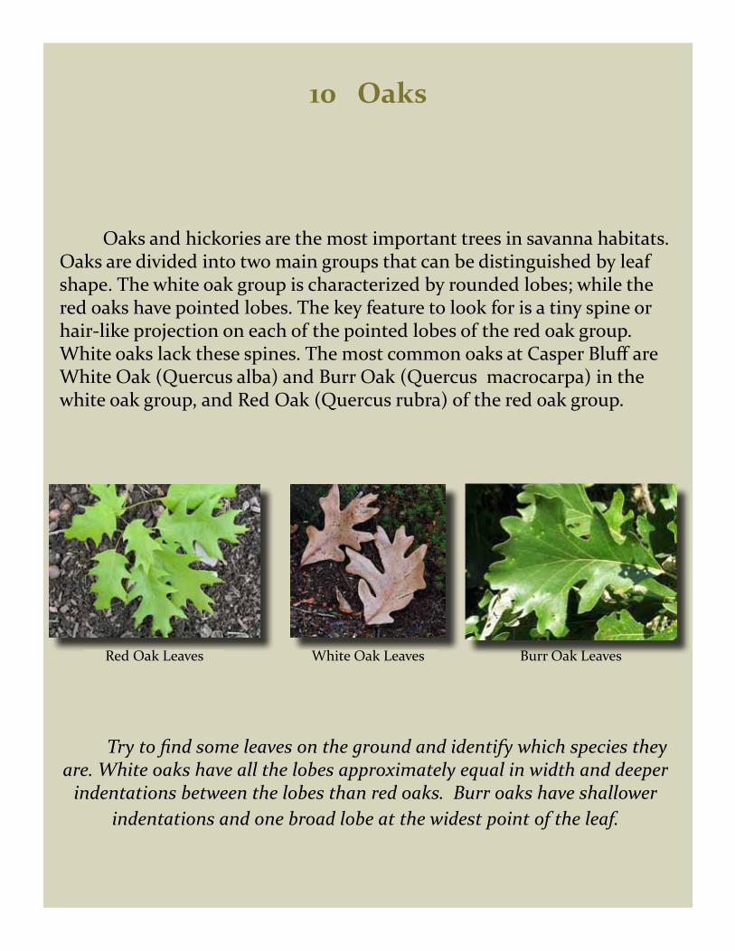
Oaks and hickories are the most important trees in savanna habitats. Oaks are divided into two main groups that can be distinguished by leaf shape. The white oak group is characterized by rounded lobes; while the red oaks have pointed lobes. The key feature to look for is a tiny spine or hair-like projection on each of the pointed lobes of the red oak group. White oaks lack these spines. The most common oaks at Casper Bluff are White Oak (Quercus alba) and Burr Oak (Quercus macrocarpa) in the white oak group, and Red Oak (Quercus rubra) of the red oak group.
Try to find some leaves on the ground and identify which species they are. White oaks have all the lobes approximately equal in width and deeper
indentations between the lobes than red oaks. Burr oaks have shallower indentations and one broad lobe at the widest point of the leaf.
Red Oak Leaves Burr Oak LeavesWhite Oak Leaves
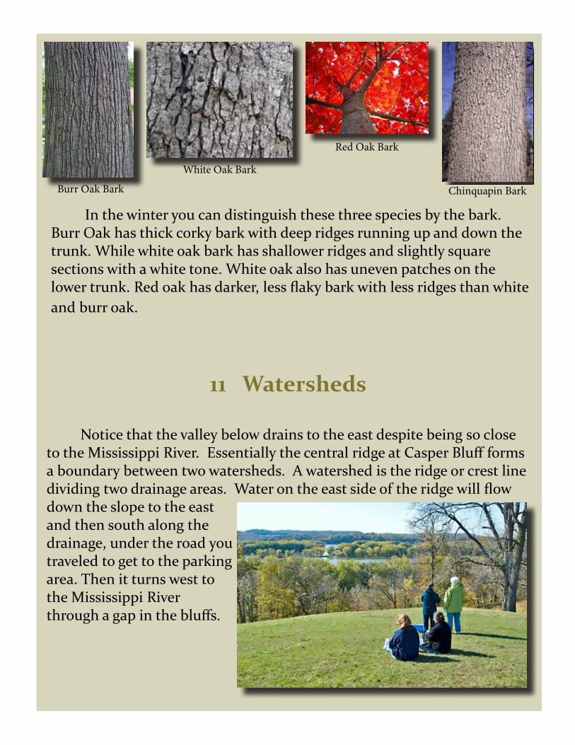
In the winter you can distinguish these three species by the bark. Burr Oak has thick corky bark with deep ridges running up and down the trunk. While white oak bark has shallower ridges and slightly square sections with a white tone. White oak also has uneven patches on the lower trunk. Red oak has darker, less flaky bark with less ridges than white and burr oak.
11 Watersheds
Notice that the valley below drains to the east despite being so close to the Mississippi River. Essentially the central ridge at Casper Bluff forms a boundary between two watersheds. A watershed is the ridge or crest line dividing two drainage areas. Water on the east side of the ridge will flow down the slope to the east and then south along the drainage, under the road you traveled to get to the parking area. Then it turns west to the Mississippi River through a gap in the bluffs.
White Oak Bark
Chinquapin BarkBurr Oak Bark
Red Oak Bark

12 Hill Prairie
13 Plant Mystery
At Casper Bluff several plants usually found in wetlands or mesic soil conditions are found on the ridge tops. Why they are here is a bit of a mystery. One possibility is that this area has a perched aquifer—a pocket of ground water held on top of a layer of impermeable rock. If so, one would expect to find seeps or springs along the side of the bluff or hillside if the edge of the rock layer is exposed. However, no seeps or springs are obvious here. Another possibility is that Native Americans brought the plants here as seeds when they brought soil from other areas to build various mounds. Which explanation do you think is most likely?
Hill prairies are island-like prairie openings occurring on steep slopes that were otherwise forested. A combination of factors result in drought conditions, such as south and west facing slopes, steep slope angles, dry prevailing winds, and well drained soils that allow for growth of prairie species. The hill prairie at Casper Bluff is a loess hill prairie, meaning the soils are of wind blown glacial deposits. Notice the clear difference in the vegetation across the fence where grazing did not occur.

Thank You for visiting Casper Bluff Land & Water Reserve.
Please consider becoming a member of the Jo Daviess Conservation Foundation today!
Jo Daviess Conservation FoundationPO Box 216126 N Main
Elizabeth, IL 61028815.858.9100
Design & Layout Assisted by Stephanie JerryGraphic Communications Class
Jo Daviess Carroll Area Vocational Center
I M A G I N G • P R I N T • I N T E R A C T I V E
2917 North Latoria Lane, Franklin Park, IL 60131
847-455-1588 / www.tukaiz.com
Printing courtesy of: