CASE STUDY - Thuraya | Mobile Satellite … teams with WiCis to stream real-time health data from...
5
Thuraya teams with WiCis to stream real-time health data from wearable technology in the Himalayas Case Study: WiCis wearable technology Products: Thuraya IP+ Thuraya SatSleeve+ Location: Upper Mustang - Nepal How many lives would be saved, on Everest or any other mountain, if doctors could monitor climbers’ vital signs remotely via satellite in real time. Two key features set the Thuraya/WiCis solution apart from other satellite-enabled wearable health monitoring and personal tracking solutions. CASE STUDY 1 The world’s highest mountain is also one of the most deadly. Since Hillary and Tenzing became the first people to reach the summit of Everest in 1953, at least 260 climbers have died on the mountain – mainly in the notorious “death zone” above 8,000 metres. Some die in falls or avalanches, but most succumb to medical conditions such as oedema, hypothermia and cardiac arrest after pushing themselves too hard and too far in the ultra-thin air. Get sick in the death zone and your life is on the line, with little chance of medical assistance. But how many lives would be saved, on Everest or any other mountain, if doctors could monitor climbers’ vital signs remotely via satellite in real time, and then raise the alarm immediately when a serious medical condition arose? With the extra minutes or hours of warning, sick climbers could call for rescue or turn back in time to save themselves. Also, the system would provide a record of recent health data to help doctors decide on the best treatment. It was to launch just such a system that Thuraya teamed up with WiCis, a company specialising in the collection and analysis of data from wearable health monitoring devices. In March 2016, WiCis CEO Dr Leo Montejo participated in an expedition to the Himalayas to trial the WiCis-Sports app over the Thuraya service, using a range of wearable health monitoring devices to collect data from test subjects climbing at altitude. Already a proven success over 3G, 4G and other terrestrial networks, the object was to test how effectively the app would work over a satellite connection as part of a joint Thuraya/WiCis solution. A world of connected devices and applications Thuraya’s work in wearables is just one aspect of its leadership in the development of satellite-connected devices. The same technology that allows adventurers to stream their health data in real time is already used extensively for Machine-to-Machine (M2M) applications in sectors as diverse as banking, border control and oil and gas. And, as the growth of the Internet of Things (IoT) gathers pace, it will provide the essential satellite overlay required to ensure seamless, uninterrupted connectivity in all locations. Lhakpa Sherpa uses the Thuraya-WiCis solution during a helicopter rescue in Upper Mustang, Nepal.
Transcript of CASE STUDY - Thuraya | Mobile Satellite … teams with WiCis to stream real-time health data from...

Thuraya teams with WiCis to stream real-time health data from wearable technology in the Himalayas
Case Study:WiCis wearable technology
Products: Thuraya IP+Thuraya SatSleeve+
Location: Upper Mustang - Nepal
How many lives would be saved, on Everest or any other mountain, if doctors could monitor climbers’ vital signs remotely via satellite in real time.
Two key features set the Thuraya/WiCis solution apart from other satellite-enabled wearable health monitoring and personal tracking solutions.
CASE STUDY
1
The world’s highest mountain is also one of the most deadly. Since Hillary and Tenzing became the first people to reach the summit of Everest in 1953, at least 260 climbers have died on the mountain – mainly in the notorious “death zone” above 8,000 metres.
Some die in falls or avalanches, but most succumb to medical conditions such as oedema, hypothermia and cardiac arrest after pushing themselves too hard and too far in the ultra-thin air. Get sick in the death zone and your life is on the line, with little chance of medical assistance.
But how many lives would be saved, on Everest or any other mountain, if doctors could monitor climbers’ vital signs remotely via satellite in real time, and then raise the alarm immediately when a serious medical condition arose? With the extra minutes or hours of warning, sick climbers could call for
rescue or turn back in time to save themselves. Also, the system would provide a record of recent health data to help doctors decide on the best treatment.
It was to launch just such a system that Thuraya teamed up with WiCis, a company specialising in the collection and analysis of data from wearable health monitoring devices. In March 2016, WiCis CEO Dr Leo Montejo participated in an expedition to the Himalayas to trial the WiCis-Sports app over the Thuraya service, using a range of wearable health monitoring devices to collect data from test subjects climbing at altitude. Already a proven success over 3G, 4G and other terrestrial networks, the object was to test how effectively the app would work over a satellite connection as part of a joint Thuraya/WiCis solution.
Bluetooth connection between the devices and the WiCis-Sports app on a smartphone (the app is the interface that gathers health data and allows it to be transmitted in usable form over the internet). Finally, the smartphone was connected to the Thuraya SatSleeve+ to establish a continuous data stream via satellite.
The SatSleeve+ has an omni-directional antenna, so the adventurer does not have to worry about precisely pointing the Thuraya device in the direction of the satellite. Once it is switched on and streaming, he or she can forget about it and just concentrate on the day’s trek. With a lightweight back-up battery attached, the team found they could stream continuously from the SatSleeve+ for eight hours a day without any problem, and recharge the batteries with portable solar panels.
At the end of each day, the Thuraya IP+ terminal gave the team a broadband connection for accessing the internet from camp and sending or receiving large data files and emails. This was not part of the wearables trial, but it proved
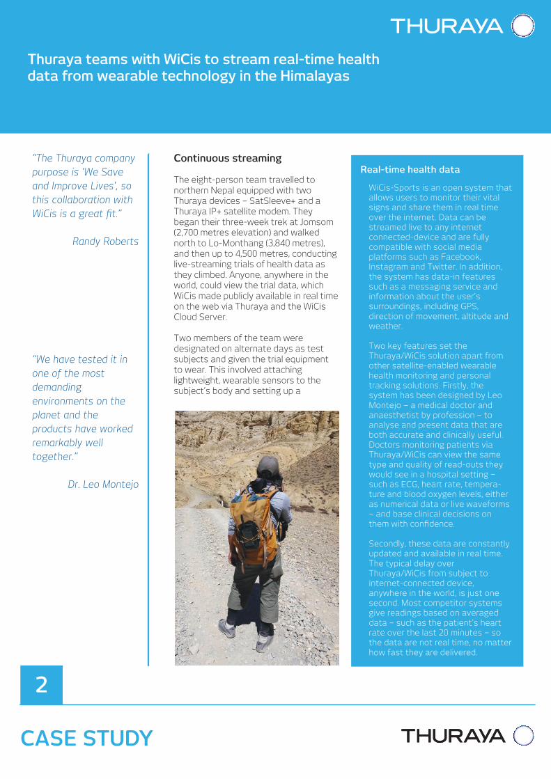
Continuous streaming
The eight-person team travelled to northern Nepal equipped with two Thuraya devices – SatSleeve+ and a Thuraya IP+ satellite modem. They began their three-week trek at Jomsom (2,700 metres elevation) and walked north to Lo-Monthang (3,840 metres), and then up to 4,500 metres, conducting live-streaming trials of health data as they climbed. Anyone, anywhere in the world, could view the trial data, which WiCis made publicly available in real time on the web via Thuraya and the WiCis Cloud Server.
Two members of the team were designated on alternate days as test subjects and given the trial equipment to wear. This involved attaching lightweight, wearable sensors to the subject’s body and setting up a
once again the portability, reliability and ease of use of the Thuraya IP service in remote and difficult locations.
Leo Montejo and his team were delighted with the performance of the Thuraya equipment and network throughout the trial. They tested the Thuraya/WiCis solution with wearable health monitoring devices from established manufacturers such as MDS, Nonin and Choicemmed, and consistently recorded strong results. The eShirt from MDS was tested extensively. This lightweight device is worn next to the skin and has embedded or integrated sensors that measure vital signs data such as ECG, heart rate, skin temperature and respiratory rate.
Commenting on the Thuraya/WiCis solution, Randy Roberts, Thuraya Chief Innovation Officer, said: “The Thuraya company purpose is ‘We Save and Improve Lives’, so this collaboration with WiCis is a great fit. As long as there are mountains and remote regions to explore, adventurers will always want to push the boundaries of what is possible.”
“Thuraya-connected wearables will help them explore farther, better and safer. Our innovative approach to personal technology is unlocking the potential of
wearable devices in remote places – far beyond the reach of GSM and WiFi – by guaranteeing a secure satellite connection to the outside world, and without the hassle of dropped signals and cellular roaming.”
Safety precautions
Although this was a carefully conducted trial and not a mountain ascent, the dangers of the harsh Himalayan environment were ever present. Three of the expedition members had to drop out due to illness, and one case of acute mountain sickness was so serious the team had to use the Thuraya phone to call a rescue helicopter to take the patient down the mountain.
Medical emergencies are just one of many hazards facing mountaineers. Another is the weather, which is notoriously changeable in the Himalayas. Clear skies and bright sunshine are often replaced in minutes by howling snow storms and almost zero visibility, so reliable forecasts are a vital safety consideration.
A world of connected devices and applications
Thuraya’s work in wearables is just one aspect of its leadership in the development of satellite-connected devices. The same technology that allows adventurers to stream their health data in real time is already used extensively for Machine-to-Machine (M2M) applications in sectors as diverse as banking, border control and oil and gas. And, as the growth of the Internet of Things (IoT) gathers pace, it will provide the essential satellite overlay required to ensure seamless, uninterrupted connectivity in all locations.
During the trial, WiCis included weather forecasts taken from the OCENS WeatherNet service in the Thuraya/WiCis solution. They proved remarkably accurate and the team quickly came to rely on them, as illustrated by this Tweet from WiCis President Carlota Fenes on 27 March: “Amazing! Our GPS pinpoint weather service from OCENS predicted snow at 14:45. It's 15:30 & snowing!”
Standard kit of the future
Leo Montejo was impressed by the performance of the Thuraya/WiCis solution in the Himalayas. “We have tested it in one of the most demanding environments on the planet and the products have worked remarkably well together,” he said. “The SatSleeve+ is easy to use, reliable and blends nicely with the WiCis-Sports app. We can definitely say that the trial was so successful that we will team up with Madison Mountaineering in June and send it up to K2.”
The commercial potential of the solution is clear, both in mountain climbing and other sports and leisure pursuits. Why would any serious climber or extreme-sports participant travel to a remote and dangerous place without the back-up of real-time health monitoring via a lightweight wearable solution – with accurate location, movement and weather information part of the package? Leo Montejo thinks the Thuraya/WiCis solution will soon become standard expedition kit. “Within five years I predict every group setting out to climb Everest, or any other high mountain, will want to take this equipment with them.” Perhaps then the “death zone” will begin to lose its fearsome reputation.
To learn more about Thuraya SatSleeve+, visit: www.thuraya.com/satsleeve-plus
To learn more about Thuraya IP+, visit www.thuraya.com/thuraya-ip-plus
To learn more about the WiCis-Sports app and the Thuraya collaboration, visit:www.wicis-sports.com/index.php/partnerships/thuraya
Lhakpa Sherpa uses the Thuraya-WiCis solution during a helicopter rescue in Upper Mustang, Nepal.
The world’s highest mountain is also one of the most deadly. Since Hillary and Tenzing became the first people to reach the summit of Everest in 1953, at least 260 climbers have died on the mountain – mainly in the notorious “death zone” above 8,000 metres.
Some die in falls or avalanches, but most succumb to medical conditions such as oedema, hypothermia and cardiac arrest after pushing themselves too hard and too far in the ultra-thin air. Get sick in the death zone and your life is on the line, with little chance of medical assistance.
But how many lives would be saved, on Everest or any other mountain, if doctors could monitor climbers’ vital signs remotely via satellite in real time, and then raise the alarm immediately when a serious medical condition arose? With the extra minutes or hours of warning, sick climbers could call for
rescue or turn back in time to save themselves. Also, the system would provide a record of recent health data to help doctors decide on the best treatment.
It was to launch just such a system that Thuraya teamed up with WiCis, a company specialising in the collection and analysis of data from wearable health monitoring devices. In March 2016, WiCis CEO Dr Leo Montejo participated in an expedition to the Himalayas to trial the WiCis-Sports app over the Thuraya service, using a range of wearable health monitoring devices to collect data from test subjects climbing at altitude. Already a proven success over 3G, 4G and other terrestrial networks, the object was to test how effectively the app would work over a satellite connection as part of a joint Thuraya/WiCis solution.
“We have tested it in one of the most demanding environments on the planet and the products have worked remarkably well together.”
Dr. Leo Montejo
“The Thuraya company purpose is ‘We Save and Improve Lives’, so this collaboration with WiCis is a great fit.”
Randy Roberts
Bluetooth connection between the devices and the WiCis-Sports app on a smartphone (the app is the interface that gathers health data and allows it to be transmitted in usable form over the internet). Finally, the smartphone was connected to the Thuraya SatSleeve+ to establish a continuous data stream via satellite.
The SatSleeve+ has an omni-directional antenna, so the adventurer does not have to worry about precisely pointing the Thuraya device in the direction of the satellite. Once it is switched on and streaming, he or she can forget about it and just concentrate on the day’s trek. With a lightweight back-up battery attached, the team found they could stream continuously from the SatSleeve+ for eight hours a day without any problem, and recharge the batteries with portable solar panels.
At the end of each day, the Thuraya IP+ terminal gave the team a broadband connection for accessing the internet from camp and sending or receiving large data files and emails. This was not part of the wearables trial, but it proved
Continuous streaming
The eight-person team travelled to northern Nepal equipped with two Thuraya devices – SatSleeve+ and a Thuraya IP+ satellite modem. They began their three-week trek at Jomsom (2,700 metres elevation) and walked north to Lo-Monthang (3,840 metres), and then up to 4,500 metres, conducting live-streaming trials of health data as they climbed. Anyone, anywhere in the world, could view the trial data, which WiCis made publicly available in real time on the web via Thuraya and the WiCis Cloud Server.
Two members of the team were designated on alternate days as test subjects and given the trial equipment to wear. This involved attaching lightweight, wearable sensors to the subject’s body and setting up a
Thuraya teams with WiCis to stream real-time health data from wearable technology in the Himalayas
CASE STUDY
2
once again the portability, reliability and ease of use of the Thuraya IP service in remote and difficult locations.
Leo Montejo and his team were delighted with the performance of the Thuraya equipment and network throughout the trial. They tested the Thuraya/WiCis solution with wearable health monitoring devices from established manufacturers such as MDS, Nonin and Choicemmed, and consistently recorded strong results. The eShirt from MDS was tested extensively. This lightweight device is worn next to the skin and has embedded or integrated sensors that measure vital signs data such as ECG, heart rate, skin temperature and respiratory rate.
Commenting on the Thuraya/WiCis solution, Randy Roberts, Thuraya Chief Innovation Officer, said: “The Thuraya company purpose is ‘We Save and Improve Lives’, so this collaboration with WiCis is a great fit. As long as there are mountains and remote regions to explore, adventurers will always want to push the boundaries of what is possible.”
“Thuraya-connected wearables will help them explore farther, better and safer. Our innovative approach to personal technology is unlocking the potential of
wearable devices in remote places – far beyond the reach of GSM and WiFi – by guaranteeing a secure satellite connection to the outside world, and without the hassle of dropped signals and cellular roaming.”
Safety precautions
Although this was a carefully conducted trial and not a mountain ascent, the dangers of the harsh Himalayan environment were ever present. Three of the expedition members had to drop out due to illness, and one case of acute mountain sickness was so serious the team had to use the Thuraya phone to call a rescue helicopter to take the patient down the mountain.
Medical emergencies are just one of many hazards facing mountaineers. Another is the weather, which is notoriously changeable in the Himalayas. Clear skies and bright sunshine are often replaced in minutes by howling snow storms and almost zero visibility, so reliable forecasts are a vital safety consideration.
During the trial, WiCis included weather forecasts taken from the OCENS WeatherNet service in the Thuraya/WiCis solution. They proved remarkably accurate and the team quickly came to rely on them, as illustrated by this Tweet from WiCis President Carlota Fenes on 27 March: “Amazing! Our GPS pinpoint weather service from OCENS predicted snow at 14:45. It's 15:30 & snowing!”
Standard kit of the future
Leo Montejo was impressed by the performance of the Thuraya/WiCis solution in the Himalayas. “We have tested it in one of the most demanding environments on the planet and the products have worked remarkably well together,” he said. “The SatSleeve+ is easy to use, reliable and blends nicely with the WiCis-Sports app. We can definitely say that the trial was so successful that we will team up with Madison Mountaineering in June and send it up to K2.”
The commercial potential of the solution is clear, both in mountain climbing and other sports and leisure pursuits. Why would any serious climber or extreme-sports participant travel to a remote and dangerous place without the back-up of real-time health monitoring via a lightweight wearable solution – with accurate location, movement and weather information part of the package? Leo Montejo thinks the Thuraya/WiCis solution will soon become standard expedition kit. “Within five years I predict every group setting out to climb Everest, or any other high mountain, will want to take this equipment with them.” Perhaps then the “death zone” will begin to lose its fearsome reputation.
To learn more about Thuraya SatSleeve+, visit: www.thuraya.com/satsleeve-plus
To learn more about Thuraya IP+, visit www.thuraya.com/thuraya-ip-plus
To learn more about the WiCis-Sports app and the Thuraya collaboration, visit:www.wicis-sports.com/index.php/partnerships/thuraya
Real-time health data
WiCis-Sports is an open system that allows users to monitor their vital signs and share them in real time over the internet. Data can be streamed live to any internet connected-device and are fully compatible with social media platforms such as Facebook, Instagram and Twitter. In addition, the system has data-in features such as a messaging service and information about the user’s surroundings, including GPS, direction of movement, altitude and weather.
Two key features set the Thuraya/WiCis solution apart from other satellite-enabled wearable health monitoring and personal tracking solutions. Firstly, the system has been designed by Leo Montejo – a medical doctor and anaesthetist by profession – to analyse and present data that are both accurate and clinically useful. Doctors monitoring patients via Thuraya/WiCis can view the same type and quality of read-outs they would see in a hospital setting – such as ECG, heart rate, tempera-ture and blood oxygen levels, either as numerical data or live waveforms – and base clinical decisions on them with confidence.
Secondly, these data are constantly updated and available in real time. The typical delay over Thuraya/WiCis from subject to internet-connected device, anywhere in the world, is just one second. Most competitor systems give readings based on averaged data – such as the patient’s heart rate over the last 20 minutes – so the data are not real time, no matter how fast they are delivered.

The world’s highest mountain is also one of the most deadly. Since Hillary and Tenzing became the first people to reach the summit of Everest in 1953, at least 260 climbers have died on the mountain – mainly in the notorious “death zone” above 8,000 metres.
Some die in falls or avalanches, but most succumb to medical conditions such as oedema, hypothermia and cardiac arrest after pushing themselves too hard and too far in the ultra-thin air. Get sick in the death zone and your life is on the line, with little chance of medical assistance.
But how many lives would be saved, on Everest or any other mountain, if doctors could monitor climbers’ vital signs remotely via satellite in real time, and then raise the alarm immediately when a serious medical condition arose? With the extra minutes or hours of warning, sick climbers could call for
rescue or turn back in time to save themselves. Also, the system would provide a record of recent health data to help doctors decide on the best treatment.
It was to launch just such a system that Thuraya teamed up with WiCis, a company specialising in the collection and analysis of data from wearable health monitoring devices. In March 2016, WiCis CEO Dr Leo Montejo participated in an expedition to the Himalayas to trial the WiCis-Sports app over the Thuraya service, using a range of wearable health monitoring devices to collect data from test subjects climbing at altitude. Already a proven success over 3G, 4G and other terrestrial networks, the object was to test how effectively the app would work over a satellite connection as part of a joint Thuraya/WiCis solution.
Thuraya teams with WiCis to stream real-time health data from wearable technology in the Himalayas
CASE STUDY
3
Bluetooth connection between the devices and the WiCis-Sports app on a smartphone (the app is the interface that gathers health data and allows it to be transmitted in usable form over the internet). Finally, the smartphone was connected to the Thuraya SatSleeve+ to establish a continuous data stream via satellite.
The SatSleeve+ has an omni-directional antenna, so the adventurer does not have to worry about precisely pointing the Thuraya device in the direction of the satellite. Once it is switched on and streaming, he or she can forget about it and just concentrate on the day’s trek. With a lightweight back-up battery attached, the team found they could stream continuously from the SatSleeve+ for eight hours a day without any problem, and recharge the batteries with portable solar panels.
At the end of each day, the Thuraya IP+ terminal gave the team a broadband connection for accessing the internet from camp and sending or receiving large data files and emails. This was not part of the wearables trial, but it proved
Continuous streaming
The eight-person team travelled to northern Nepal equipped with two Thuraya devices – SatSleeve+ and a Thuraya IP+ satellite modem. They began their three-week trek at Jomsom (2,700 metres elevation) and walked north to Lo-Monthang (3,840 metres), and then up to 4,500 metres, conducting live-streaming trials of health data as they climbed. Anyone, anywhere in the world, could view the trial data, which WiCis made publicly available in real time on the web via Thuraya and the WiCis Cloud Server.
Two members of the team were designated on alternate days as test subjects and given the trial equipment to wear. This involved attaching lightweight, wearable sensors to the subject’s body and setting up a
once again the portability, reliability and ease of use of the Thuraya IP service in remote and difficult locations.
Leo Montejo and his team were delighted with the performance of the Thuraya equipment and network throughout the trial. They tested the Thuraya/WiCis solution with wearable health monitoring devices from established manufacturers such as MDS, Nonin and Choicemmed, and consistently recorded strong results. The eShirt from MDS was tested extensively. This lightweight device is worn next to the skin and has embedded or integrated sensors that measure vital signs data such as ECG, heart rate, skin temperature and respiratory rate.
Commenting on the Thuraya/WiCis solution, Randy Roberts, Thuraya Chief Innovation Officer, said: “The Thuraya company purpose is ‘We Save and Improve Lives’, so this collaboration with WiCis is a great fit. As long as there are mountains and remote regions to explore, adventurers will always want to push the boundaries of what is possible.”
“Thuraya-connected wearables will help them explore farther, better and safer. Our innovative approach to personal technology is unlocking the potential of
wearable devices in remote places – far beyond the reach of GSM and WiFi – by guaranteeing a secure satellite connection to the outside world, and without the hassle of dropped signals and cellular roaming.”
Safety precautions
Although this was a carefully conducted trial and not a mountain ascent, the dangers of the harsh Himalayan environment were ever present. Three of the expedition members had to drop out due to illness, and one case of acute mountain sickness was so serious the team had to use the Thuraya phone to call a rescue helicopter to take the patient down the mountain.
Medical emergencies are just one of many hazards facing mountaineers. Another is the weather, which is notoriously changeable in the Himalayas. Clear skies and bright sunshine are often replaced in minutes by howling snow storms and almost zero visibility, so reliable forecasts are a vital safety consideration.
“Amazing! Our GPS pinpoint weather service from OCENS predicted snow at 14:45. It's 15:30 & snowing!”
Carlota Fenes
During the trial, WiCis included weather forecasts taken from the OCENS WeatherNet service in the Thuraya/WiCis solution. They proved remarkably accurate and the team quickly came to rely on them, as illustrated by this Tweet from WiCis President Carlota Fenes on 27 March: “Amazing! Our GPS pinpoint weather service from OCENS predicted snow at 14:45. It's 15:30 & snowing!”
Standard kit of the future
Leo Montejo was impressed by the performance of the Thuraya/WiCis solution in the Himalayas. “We have tested it in one of the most demanding environments on the planet and the products have worked remarkably well together,” he said. “The SatSleeve+ is easy to use, reliable and blends nicely with the WiCis-Sports app. We can definitely say that the trial was so successful that we will team up with Madison Mountaineering in June and send it up to K2.”
The commercial potential of the solution is clear, both in mountain climbing and other sports and leisure pursuits. Why would any serious climber or extreme-sports participant travel to a remote and dangerous place without the back-up of real-time health monitoring via a lightweight wearable solution – with accurate location, movement and weather information part of the package? Leo Montejo thinks the Thuraya/WiCis solution will soon become standard expedition kit. “Within five years I predict every group setting out to climb Everest, or any other high mountain, will want to take this equipment with them.” Perhaps then the “death zone” will begin to lose its fearsome reputation.
To learn more about Thuraya SatSleeve+, visit: www.thuraya.com/satsleeve-plus
To learn more about Thuraya IP+, visit www.thuraya.com/thuraya-ip-plus
To learn more about the WiCis-Sports app and the Thuraya collaboration, visit:www.wicis-sports.com/index.php/partnerships/thuraya

The world’s highest mountain is also one of the most deadly. Since Hillary and Tenzing became the first people to reach the summit of Everest in 1953, at least 260 climbers have died on the mountain – mainly in the notorious “death zone” above 8,000 metres.
Some die in falls or avalanches, but most succumb to medical conditions such as oedema, hypothermia and cardiac arrest after pushing themselves too hard and too far in the ultra-thin air. Get sick in the death zone and your life is on the line, with little chance of medical assistance.
But how many lives would be saved, on Everest or any other mountain, if doctors could monitor climbers’ vital signs remotely via satellite in real time, and then raise the alarm immediately when a serious medical condition arose? With the extra minutes or hours of warning, sick climbers could call for
rescue or turn back in time to save themselves. Also, the system would provide a record of recent health data to help doctors decide on the best treatment.
It was to launch just such a system that Thuraya teamed up with WiCis, a company specialising in the collection and analysis of data from wearable health monitoring devices. In March 2016, WiCis CEO Dr Leo Montejo participated in an expedition to the Himalayas to trial the WiCis-Sports app over the Thuraya service, using a range of wearable health monitoring devices to collect data from test subjects climbing at altitude. Already a proven success over 3G, 4G and other terrestrial networks, the object was to test how effectively the app would work over a satellite connection as part of a joint Thuraya/WiCis solution.
Bluetooth connection between the devices and the WiCis-Sports app on a smartphone (the app is the interface that gathers health data and allows it to be transmitted in usable form over the internet). Finally, the smartphone was connected to the Thuraya SatSleeve+ to establish a continuous data stream via satellite.
The SatSleeve+ has an omni-directional antenna, so the adventurer does not have to worry about precisely pointing the Thuraya device in the direction of the satellite. Once it is switched on and streaming, he or she can forget about it and just concentrate on the day’s trek. With a lightweight back-up battery attached, the team found they could stream continuously from the SatSleeve+ for eight hours a day without any problem, and recharge the batteries with portable solar panels.
At the end of each day, the Thuraya IP+ terminal gave the team a broadband connection for accessing the internet from camp and sending or receiving large data files and emails. This was not part of the wearables trial, but it proved
Continuous streaming
The eight-person team travelled to northern Nepal equipped with two Thuraya devices – SatSleeve+ and a Thuraya IP+ satellite modem. They began their three-week trek at Jomsom (2,700 metres elevation) and walked north to Lo-Monthang (3,840 metres), and then up to 4,500 metres, conducting live-streaming trials of health data as they climbed. Anyone, anywhere in the world, could view the trial data, which WiCis made publicly available in real time on the web via Thuraya and the WiCis Cloud Server.
Two members of the team were designated on alternate days as test subjects and given the trial equipment to wear. This involved attaching lightweight, wearable sensors to the subject’s body and setting up a
CASE STUDY
4
once again the portability, reliability and ease of use of the Thuraya IP service in remote and difficult locations.
Leo Montejo and his team were delighted with the performance of the Thuraya equipment and network throughout the trial. They tested the Thuraya/WiCis solution with wearable health monitoring devices from established manufacturers such as MDS, Nonin and Choicemmed, and consistently recorded strong results. The eShirt from MDS was tested extensively. This lightweight device is worn next to the skin and has embedded or integrated sensors that measure vital signs data such as ECG, heart rate, skin temperature and respiratory rate.
Commenting on the Thuraya/WiCis solution, Randy Roberts, Thuraya Chief Innovation Officer, said: “The Thuraya company purpose is ‘We Save and Improve Lives’, so this collaboration with WiCis is a great fit. As long as there are mountains and remote regions to explore, adventurers will always want to push the boundaries of what is possible.”
“Thuraya-connected wearables will help them explore farther, better and safer. Our innovative approach to personal technology is unlocking the potential of
wearable devices in remote places – far beyond the reach of GSM and WiFi – by guaranteeing a secure satellite connection to the outside world, and without the hassle of dropped signals and cellular roaming.”
Safety precautions
Although this was a carefully conducted trial and not a mountain ascent, the dangers of the harsh Himalayan environment were ever present. Three of the expedition members had to drop out due to illness, and one case of acute mountain sickness was so serious the team had to use the Thuraya phone to call a rescue helicopter to take the patient down the mountain.
Medical emergencies are just one of many hazards facing mountaineers. Another is the weather, which is notoriously changeable in the Himalayas. Clear skies and bright sunshine are often replaced in minutes by howling snow storms and almost zero visibility, so reliable forecasts are a vital safety consideration.
“The SatSleeve+ is easy to use, reliable and blends nicely with the WiCis-Sports app.”
Dr. Leo Montejo
Thuraya teams with WiCis to stream real-time health data from wearable technology in the Himalayas
During the trial, WiCis included weather forecasts taken from the OCENS WeatherNet service in the Thuraya/WiCis solution. They proved remarkably accurate and the team quickly came to rely on them, as illustrated by this Tweet from WiCis President Carlota Fenes on 27 March: “Amazing! Our GPS pinpoint weather service from OCENS predicted snow at 14:45. It's 15:30 & snowing!”
Standard kit of the future
Leo Montejo was impressed by the performance of the Thuraya/WiCis solution in the Himalayas. “We have tested it in one of the most demanding environments on the planet and the products have worked remarkably well together,” he said. “The SatSleeve+ is easy to use, reliable and blends nicely with the WiCis-Sports app. We can definitely say that the trial was so successful that we will team up with Madison Mountaineering in June and send it up to K2.”
The commercial potential of the solution is clear, both in mountain climbing and other sports and leisure pursuits. Why would any serious climber or extreme-sports participant travel to a remote and dangerous place without the back-up of real-time health monitoring via a lightweight wearable solution – with accurate location, movement and weather information part of the package? Leo Montejo thinks the Thuraya/WiCis solution will soon become standard expedition kit. “Within five years I predict every group setting out to climb Everest, or any other high mountain, will want to take this equipment with them.” Perhaps then the “death zone” will begin to lose its fearsome reputation.
To learn more about Thuraya SatSleeve+, visit: www.thuraya.com/satsleeve-plus
To learn more about Thuraya IP+, visit www.thuraya.com/thuraya-ip-plus
To learn more about the WiCis-Sports app and the Thuraya collaboration, visit:www.wicis-sports.com/index.php/partnerships/thuraya
Temperature
Heart Rate
Bluetooth Wi-Fi
Thuraya SatSleeve+Smartphone
ISPSatellite
Oxygen Saturation
GPS From Phone

The world’s highest mountain is also one of the most deadly. Since Hillary and Tenzing became the first people to reach the summit of Everest in 1953, at least 260 climbers have died on the mountain – mainly in the notorious “death zone” above 8,000 metres.
Some die in falls or avalanches, but most succumb to medical conditions such as oedema, hypothermia and cardiac arrest after pushing themselves too hard and too far in the ultra-thin air. Get sick in the death zone and your life is on the line, with little chance of medical assistance.
But how many lives would be saved, on Everest or any other mountain, if doctors could monitor climbers’ vital signs remotely via satellite in real time, and then raise the alarm immediately when a serious medical condition arose? With the extra minutes or hours of warning, sick climbers could call for
rescue or turn back in time to save themselves. Also, the system would provide a record of recent health data to help doctors decide on the best treatment.
It was to launch just such a system that Thuraya teamed up with WiCis, a company specialising in the collection and analysis of data from wearable health monitoring devices. In March 2016, WiCis CEO Dr Leo Montejo participated in an expedition to the Himalayas to trial the WiCis-Sports app over the Thuraya service, using a range of wearable health monitoring devices to collect data from test subjects climbing at altitude. Already a proven success over 3G, 4G and other terrestrial networks, the object was to test how effectively the app would work over a satellite connection as part of a joint Thuraya/WiCis solution.
Bluetooth connection between the devices and the WiCis-Sports app on a smartphone (the app is the interface that gathers health data and allows it to be transmitted in usable form over the internet). Finally, the smartphone was connected to the Thuraya SatSleeve+ to establish a continuous data stream via satellite.
The SatSleeve+ has an omni-directional antenna, so the adventurer does not have to worry about precisely pointing the Thuraya device in the direction of the satellite. Once it is switched on and streaming, he or she can forget about it and just concentrate on the day’s trek. With a lightweight back-up battery attached, the team found they could stream continuously from the SatSleeve+ for eight hours a day without any problem, and recharge the batteries with portable solar panels.
At the end of each day, the Thuraya IP+ terminal gave the team a broadband connection for accessing the internet from camp and sending or receiving large data files and emails. This was not part of the wearables trial, but it proved
Continuous streaming
The eight-person team travelled to northern Nepal equipped with two Thuraya devices – SatSleeve+ and a Thuraya IP+ satellite modem. They began their three-week trek at Jomsom (2,700 metres elevation) and walked north to Lo-Monthang (3,840 metres), and then up to 4,500 metres, conducting live-streaming trials of health data as they climbed. Anyone, anywhere in the world, could view the trial data, which WiCis made publicly available in real time on the web via Thuraya and the WiCis Cloud Server.
Two members of the team were designated on alternate days as test subjects and given the trial equipment to wear. This involved attaching lightweight, wearable sensors to the subject’s body and setting up a
once again the portability, reliability and ease of use of the Thuraya IP service in remote and difficult locations.
Leo Montejo and his team were delighted with the performance of the Thuraya equipment and network throughout the trial. They tested the Thuraya/WiCis solution with wearable health monitoring devices from established manufacturers such as MDS, Nonin and Choicemmed, and consistently recorded strong results. The eShirt from MDS was tested extensively. This lightweight device is worn next to the skin and has embedded or integrated sensors that measure vital signs data such as ECG, heart rate, skin temperature and respiratory rate.
Commenting on the Thuraya/WiCis solution, Randy Roberts, Thuraya Chief Innovation Officer, said: “The Thuraya company purpose is ‘We Save and Improve Lives’, so this collaboration with WiCis is a great fit. As long as there are mountains and remote regions to explore, adventurers will always want to push the boundaries of what is possible.”
“Thuraya-connected wearables will help them explore farther, better and safer. Our innovative approach to personal technology is unlocking the potential of
wearable devices in remote places – far beyond the reach of GSM and WiFi – by guaranteeing a secure satellite connection to the outside world, and without the hassle of dropped signals and cellular roaming.”
Safety precautions
Although this was a carefully conducted trial and not a mountain ascent, the dangers of the harsh Himalayan environment were ever present. Three of the expedition members had to drop out due to illness, and one case of acute mountain sickness was so serious the team had to use the Thuraya phone to call a rescue helicopter to take the patient down the mountain.
Medical emergencies are just one of many hazards facing mountaineers. Another is the weather, which is notoriously changeable in the Himalayas. Clear skies and bright sunshine are often replaced in minutes by howling snow storms and almost zero visibility, so reliable forecasts are a vital safety consideration.
CASE STUDY
5
During the trial, WiCis included weather forecasts taken from the OCENS WeatherNet service in the Thuraya/WiCis solution. They proved remarkably accurate and the team quickly came to rely on them, as illustrated by this Tweet from WiCis President Carlota Fenes on 27 March: “Amazing! Our GPS pinpoint weather service from OCENS predicted snow at 14:45. It's 15:30 & snowing!”
Standard kit of the future
Leo Montejo was impressed by the performance of the Thuraya/WiCis solution in the Himalayas. “We have tested it in one of the most demanding environments on the planet and the products have worked remarkably well together,” he said. “The SatSleeve+ is easy to use, reliable and blends nicely with the WiCis-Sports app. We can definitely say that the trial was so successful that we will team up with Madison Mountaineering in June and send it up to K2.”
The commercial potential of the solution is clear, both in mountain climbing and other sports and leisure pursuits. Why would any serious climber or extreme-sports participant travel to a remote and dangerous place without the back-up of real-time health monitoring via a lightweight wearable solution – with accurate location, movement and weather information part of the package? Leo Montejo thinks the Thuraya/WiCis solution will soon become standard expedition kit. “Within five years I predict every group setting out to climb Everest, or any other high mountain, will want to take this equipment with them.” Perhaps then the “death zone” will begin to lose its fearsome reputation.
To learn more about Thuraya SatSleeve+, visit: www.thuraya.com/satsleeve-plus
To learn more about Thuraya IP+, visit www.thuraya.com/thuraya-ip-plus
To learn more about the WiCis-Sports app and the Thuraya collaboration, visit:www.wicis-sports.com/index.php/partnerships/thuraya
Thuraya teams with WiCis to stream real-time health data from wearable technology in the Himalayas
“Within five years I predict every group setting out to climb Everest, or any other high mountain, will want to take this equipment with them.” Perhaps then the “death zone” will begin to lose its fearsome reputation.”
Leo Montejo