Casa Grande Ruin
54
CASA GRANDE RUIN BY COSMOS MINDELEFF * * * * * CONTENTS Introduction 295 Location and character 295 History and literature 295 Description 298 The Casa Grande group 298 Casa Grande ruin 306 State of preservation 306 Dimensions 307 Detailed description 309 Openings 314 Conclusions 318 ILLUSTRATIONS Plate LI. Map of Casa Grande group 298 LII. Ground plan of Casa Grande ruin 302 LIII. General view of Casa Grande ruin 305 LIV. Standing wall near Casa Grande 307 LV. Western front of Casa Grande ruin 309 LVI. Interior wall of Casa Grande ruin 310 LVII. Blocked opening in western wall 312 LVIII. Square opening in southern room 314 LIX. Remains of lintel 317 LX. Circular opening in northern room 319 Fig. 328. Map of large mound 301 329. Map of hollow mound 304 330. Elevations of walls, middle room 315 * * * * *
-
Upload
marko-trupkovic -
Category
Documents
-
view
233 -
download
0
description
Casa Grande Ruin
Transcript of Casa Grande Ruin
CASA GRANDE RUIN
BY COSMOS MINDELEFF
* * * * *
CONTENTS
Introduction 295Location and character 295History and literature 295Description 298The Casa Grande group 298Casa Grande ruin 306State of preservation 306Dimensions 307Detailed description 309Openings 314Conclusions 318
ILLUSTRATIONS
Plate LI. Map of Casa Grande group 298LII. Ground plan of Casa Grande ruin 302LIII. General view of Casa Grande ruin 305LIV. Standing wall near Casa Grande 307LV. Western front of Casa Grande ruin 309LVI. Interior wall of Casa Grande ruin 310LVII. Blocked opening in western wall 312LVIII. Square opening in southern room 314LIX. Remains of lintel 317LX. Circular opening in northern room 319
Fig. 328. Map of large mound 301329. Map of hollow mound 304330. Elevations of walls, middle room 315
* * * * *
CASA GRANDE RUIN
By Cosmos Mindeleff
* * * * *
INTRODUCTION.
LOCATION AND CHARACTER.
The Casa Grande ruin, situated near Gila river, in southern Arizona, isperhaps the best known specimen of aboriginal architecture in the UnitedStates, and no treatise on American antiquities is complete without amore or less extended description of it. Its literature, which extendsover two centuries, is voluminous, but of little value to the practicalscientific worker, since hardly two descriptions can be found whichagree. The variations in size of the ruin given by various authors isastonishing, ranging from 1,500 square feet to nearly 5 acres or about200,000 square feet in area. These extreme variations are doubtless dueto difference of judgment as to what portion of the area covered byremains of walls should be assigned to the Casa Grande proper, for thisstructure is but a portion of a large group of ruins.
So far as known to the writer no accurate plan of the Casa Grande ruinproper has hitherto been made, although plans have been published; andvery few data concerning the group of which it forms a part areavailable. It would seem, therefore, that a brief report presentingaccurate plans and careful descriptions may be of value, even thoughno pretention to exhaustive treatment is made.
HISTORY AND LITERATURE.
The earlier writers on the Casa Grande generally state that it was inruins at the time of the first Spanish invasion of the country, in 1540,and quote in support of this assertion Castaneda's description of a ruinencountered on the march.[1] Castaneda remarks that, "The structurewas in ruins and without a roof." Elsewhere he says that the name"Chichilticale" was given to the place where they stopped because themonks found in the vicinity a house which had been inhabited by a peoplewho came from Cibola. He surmises that the ruin was formerly a fortress,destroyed long before by the barbarous tribes which they found in thecountry. His description of these tribes seems to apply to the Apache.
[Footnote 1: Castaneda in Ternaux-Compans. Voyage de Cibola. Frenchtext, p. 1, pp. 41, 161-162. (The original text--Spanish--is in theLenox Library; no English translation has yet been published.)]
The geographic data furnished by Castaneda and the other chroniclers ofCoronado's expedition is very scanty, and the exact route followed hasnot yet been determined and probably never will be. So far as these datago, however, they are against the assumption that the Chichilticale ofCastaneda is the Casa Grande of today. Mr. A. F. Bandelier, whose
studies of the documentary history of the southwest are well known,inclines to the opinion that the vicinity of Old Camp Grant, on the RioSan Pedro, Arizona, more nearly fill the descriptions. Be this as itmay, however, the work of Castaneda was lost to sight, and it is notuntil more than a century later that the authentic history of the ruincommences.
In 1694 the Jesuit Father Kino heard of the ruin, and later in the sameyear visited it and said mass within its walls. His secretary and usualcompanion on his missionary journeys, Mange by name, was not with him onthis occasion, but in 1697 another visit was paid to the ruin and thedescription recorded by Mange[1] in his diary heads the long list ofaccounts extending down to the present time.[2] Mange describes the ruinas consisting of--
A large edifice, the principal room in the center being four storieshigh, and those adjoining it on its four sides three stories, withwalls 2 varas thick, of strong argamaso y baro (adobe) so smooth onthe inside that they resemble planed boards, and so polished thatthey shine like Puebla pottery.
[Footnote 1: An English translation is given by H. H. Bancroft,Works, iv, p. 622, note. Also by Bartlett, Personal Narrative, 1854,vol. ii, pp. 281-282; another was published by Schoolcraft, Hist.Cond. and Pros. of Am. Ind., vol. iii, 1853, p. 301.]
[Footnote 2: Quite an extensive list is given by Bancroft(op. cit., pp. 622-625, notes), and by Bandelier in Papers Arch.Inst. of Amer., American series, i, p. 11, note.]
Mange also gives some details of construction, and states that in theimmediate vicinity there were remains of twelve other buildings, thewalls half fallen and the roofs burned out.
Following Mange's account there were a number of descriptions of nospecial value, and a more useful one written by Padre Font, who in 1775and 1776 made a journey to Gila and Colorado rivers and beyond. Thisdescription[1] is quite circumstantial and is of especial interestbecause it formed the basis of nearly all the accounts written up to thetime when that country came into our possession. According to thisauthority--
The house forms an oblong square, facing exactly the four cardinalpoints, and round about it there are ruins indicating a fence orwall which surrounded the house and other buildings. The exterior orplaza extends north and south 420 feet and east and west 260 feet.
[Footnote 1: A number of copies of Font's Journal are known.Bancroft gives a partial translation in op. cit., p. 623, note, asdoes also Bartlett (op. cit., pp. 278-280); and a French translation
is given by Ternaux Compans, ix, Voyages de Cibola, appendix.]
Font measured the five rooms of the main building, and recorded manyinteresting details. It will be noticed that he described a surroundingwall inclosing a comparatively large area; and nearly all the writerswho published accounts prior to our conquest of the country in 1846based their descriptions on Font's journal and erroneously applied hismeasurement of the supposed circumscribing wall to the Casa Grandeproper.
The conquest of the country by the "Army of the West" attractedattention anew to the ruin, through the descriptions of Colonel Emoryand Captain Johnston. The expedition passed up the Gila valley, andColonel Emory, in his journal, gives a fanciful illustration and aslight description. The journal of Captain Johnston contained a somewhatbetter description and a rough but fairly good sketch. The bestdescription of that period, however, was that given by John RussellBartlett, in his "Personal Narrative," published in 1854.
Bartlett observed that the ruin consists of three buildings, "allincluded within an area of 150 yards." He described these buildings andgave ground plans of two of them and elevations of the principalstructure. He also gave a translation of a portion of Font's journal, aswell as the previous description of Mange. He surmised that the centralroom of the main building, and perhaps the whole structure, was used forthe storage of corn.
Bartlett's account held place for nearly thirty years as the mainreliance of compilers, and it forms today one of the most circumstantialand comprehensive descriptions extant. Other descriptions appeared atintervals of a few years, some compiled from Bartlett and Font, othersbased on personal observation, but none of them containing anything new,until the account of Mr. A. F. Bandelier, published some ten yearsago,[1] is reached.
[Footnote 1: Archaeological Inst. of Amer., 5th Ann. Rep., 1884.]
Mr. Bandelier described the large group, of which the Casa Grande formsa part, and gave its dimensions as 400 meters (1,300 feet) north andsouth by 200 meters (650 feet) east and west. He also described and gavemeasurements of the Casa Grande proper and discusses its place in thefield of aboriginal architecture. In a later publication[1] he discussedthe ruin at somewhat greater length, and presented also a rough sketchplan of the group and ground plans of the Casa Grande and of the moundnorth of it. He gave a short history of the ruin and quite an extendedaccount of the Pima traditions concerning it. He considered the CasaGrande a stronghold or fortress, a place of last resort, thecounterpart, functionally, of the blockhouse of the early settlers ofeastern United States.
[Footnote 1: Papers Archaeol. Inst. of Amer., Amer. ser., iv,Cambridge, 1892, p. 453 et sec.]
In 1888 Mr. F. H. Cushing presented to the Congres International desAmericanistes[1] some "Preliminary notes" on his work as director of theHemenway southwestern archeological expedition. Mr. Cushing did notdescribe the Casa Grande, but merely alluded to it as a survivingexample of the temple, or principal structure, which occurred inconjunction with nearly all the settlements studied. As Mr. Cushing'swork was devoted, however, to the investigation of remains analogous to,if not identical with, the Casa Grande, his report forms a valuablecontribution to the literature of this subject, and although noteveryone can accept the broad inferences and generalizations drawn byMr. Cushing--of which he was able, unfortunately, to present only a merestatement--the report should be consulted by every student ofsouthwestern archeology.
[Footnote 1: Berlin meeting, 1888; Compte-Rendu, Berlin, 1890,p. 150 et seq.]
The latest contribution to the literature of the Casa Grande is a reportby Dr. J. Walter Fewkes,[1] also of the Hemenway expedition, under thetitle "On the present condition of a ruin in Arizona called CasaGrande." Two magnificent illustrations are presented, engravings fromphotographs, showing general views of the ruin, as well as a number ofviews depicting details, and the ground plan presented at the end of thereport is the best so far published. It is unfortunate that this authorwas not able to give more time to the study of the ruin; yet his reportis a valuable contribution to our knowledge concerning the Casa Grande.
[Footnote 1: Jour. of Amer. Ethn. and Arch., Cambridge, 1892, vol.ii, page 179 et seq.]
DESCRIPTION.
THE CASA GRANDE GROUP.
The Casa Grande has been variously placed at from 2 leagues to 2 milessouth of Gila river. The writer has never traversed the distance fromthe ruin to the river, but the ruin is about a mile from Walker ranch,which is well known in that neighborhood, and about half a mile from theriver. This question, however, is not of much importance, as the ruin iseasily found by anyone looking for it, being located directly on one ofthe stage routes from Casa Grande station, on the Southern Pacificrailroad, to Florence, Arizona, and about 9 miles below, or west of, thelatter place.
The name Casa Grande has been usually applied to a single structurestanding near the southwestern corner of a large area covered by moundsand other debris, but some writers have applied it to the southwesternportion of the area and even to the whole area. The latter seems theproper application of the term, but to avoid confusion, where both thesettlement as a whole and that portion which has formed the theme of somany writers are referred to, the settlement will be designated as theCasa Grande group, and the single structure with standing walls as theCasa Grande ruin.
Probably no two investigators would assign the same limits to the areacovered by the group, as the margins of this area merge imperceptiblyinto the surrounding country. The accompanying map (plate LI) shows thisarea as interpreted by the writer. The surface covered by well definedremains, as there shown, extends about 1,800 feet north and south and1,500 feet east and west, or a total area of about 65 acres.
[Illustration: Pl. LI: Map of Casa Grande Group.]
The Casa Grande ruin, as the term is here used, occupies a position nearthe southwestern corner of the group, and it will be noticed that itssize is insignificant as compared with that of the entire group, or evenwith the large structure in the north-central part of it. The divisionof the group into northern and southern portions, which has been made bysome writers, is clearly shown on the map; but this division is moreapparent than real. The contour interval on the map is one foot--asufficiently small interval to show the surface configuration closelyand to bring out some of its peculiarities. Depressions are shown bydotted contours. It will be noticed that while most of the mounds whichmark the sites of former structures rise but 10 feet or less above thesurrounding level, the profiles vary considerably, some being much moresmoothed off and rounded than others, the former being shown on the mapby even, "flowing" contours, while the latter are more irregular; and itwill be further noticed that the irregularity reaches its maximum in thevicinity of the Casa Grande ruin proper, where the ground surface wasmore recently formed, from the fall of walls that were standing withinthe historical period.
External appearance is a very unsafe criterion of age, although in somecases, like the present, it affords a fair basis for hypothesis as tocomparative age; but even in this case, where the various portions ofthe group have presumably been affected alike by climatic and otherinfluences, such hypothesis, while perhaps interesting, must be usedwith the greatest caution. Within a few miles of this place the writerhas seen the remains of a modern adobe house whose maximum age could notexceed a decade or two, yet which presented an appearance of antiquityquite as great as that of the wall remains east and southeast of theCasa Grande ruin.
The application of the hypothesis to the map brings out some interestingresults. In the first place, it may be seen that in the lowest mounds,such as those in the northwestern corner of the sheet, on the southernmargin, and southwest of the well-marked mound on the eastern margin,the contours are more flowing and the slopes more gentle than in others.This suggests that these smoothed mounds are older than the others, and,further, that their present height is not so great as their formerheight; and again, under this hypothesis, it suggests that the remainsdo not belong to one period, but that the interval which elapsed betweenthe abandonment of the structures whose sites are marked by the lowmounds and the most recent abandonment was long. In other words, thisgroup, under the hypothesis, affords another illustration of a factconstantly impressed on the student of southwestern village remains,that each village site marks but an epoch in the history of the tribeoccupying it--a period during which there was constant, incessantchange, new bands or minor divisions of the tribe appearing on thescene, other divisions leaving the parent village for other sites, andthe ebb and flow continuing until at some period in its history thepopulation of a village sometimes became so reduced that the remainder,as a matter of precaution, or for some trifling reason, abandoned it enmasse. This phase of pueblo life, more prominent in the olden days thanat present, but still extant, has not received the prominence itdeserves in the study of southwestern remains. Its effects can be seenin almost every ruin; not all the villages of a group, nor even all theparts of a village, were inhabited at the same time, and estimates ofpopulation based on the number of ruins within a given region, and eventhose based on the size of a given ruin, must be materially revised. Asthis subject has been elsewhere[1] discussed, it can be dismissed herewith the statement that the Casa Grande group seems to have formed noexception to the general rule, but that its population changed from timeto time, and that the extent of the remains is no criterion of theformer population.
[Footnote 1: See pp. 179-261 of this Report, "Aboriginal Remains inVerde Valley."]
It will be noticed that in some of the mounds, noticeably those in theimmediate vicinity of the Casa Grande ruin, the surface is veryirregular. In this instance the irregularity indicates a recentformation of surface; for at this point many walls now marked only bymounds were standing within the historical period. External contour isof course a product of erosion, yet similarity of contour does notnecessarily indicate either equal erosion or equal antiquity. Surfaceerosion does not become a prominent factor until after the walls havefallen, and one wall may easily last for a century or two centurieslonger than another similarly situated. The surface erosion of astanding wall of grout, such as these under discussion, is very slight;photographs of the Casa Grande ruin, extending over a period of sixteenyears, and made from practically the same point of view, show that theskyline or silhouette remained essentially unchanged during that period,
every little knob and projection remaining the same. It is throughsapping or undermining at the ground surface that walls are destroyed.An inspection of the illustrations accompanying this paper will showwhat is meant by sapping: the external walls are cut away at the groundsurface to a depth varying from a few inches to nearly 2 feet. After arain the ground, and that portion of the walls at present below itssurface, retains moisture much longer than the part of the walls whichstands clear; the moisture rises by capillary attraction a foot or twoabove the ground surface, rendering the walls at this level softer thanelsewhere, and as this portion is more exposed to the flying sand whichthe wind sweeps over the ground it is here that erosion attains itsmaximum. The wall is gradually cut away at and just above the groundsurface until finally the base becomes too small to support it and itfalls en masse. Then and not till then surface erosion becomes animportant factor and the profile of the mass becomes finally rounded.But it will be readily seen that a slight difference of texture, orthickness, or exposure, or some trifling difference too minute forobservation, might easily add many decades to the apparent age of amound. The walls once fallen, however, the rounding or smoothing of themounds would probably proceed at an equal rate throughout the group, andstudy of the profile gives a fairly good estimate as to the comparativeage of the mounds. On this basis the most ancient mounds are thosespecified above, while the most recent are those in the immediatevicinity of the Casa Grande ruin. This estimate accords well with thelimited historical data and with the Pima traditions, which recount thatthe Casa Grande ruin was the last inhabited village in this vicinity.
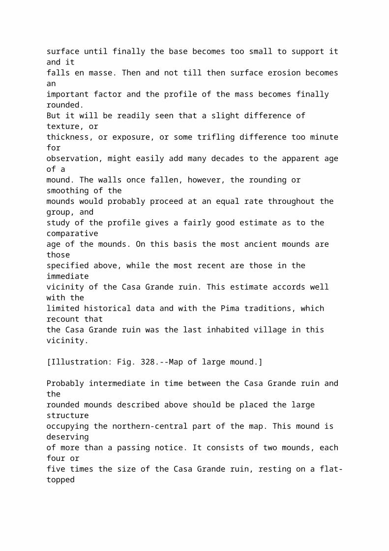
[Illustration: Fig. 328.--Map of large mound.]
Probably intermediate in time between the Casa Grande ruin and therounded mounds described above should be placed the large structureoccupying the northern-central part of the map. This mound is deservingof more than a passing notice. It consists of two mounds, each four orfive times the size of the Casa Grande ruin, resting on a flat-toppedpedestal or terrace about 5 feet above the general level. The summits ofthese mounds, which are nearly flat, are some 13 feet above this level.The sides of the mounds slope very sharply, and have suffered somewhatfrom erosion, being cut by deep gullies, as shown in figure 328, whichis an enlargement from the map. It has been stated that these structureswere mounds, pure and simple, used for sacrifice or worship, resemblingsomewhat the well-known pyramid of Cholula; but there is no doubt thatthey are the remains of house-structures, for a careful examination ofthe surface on the slopes, reveals the ends of regular walls. The heightis not exceptional, the mound on the east being less than 3 feet lower,while the one on the southeast lacks less than 4 feet of its height. Thecharacteristic feature, however, and one difficult to explain, except onthe hypothesis stated, is the sharp slope of the sides. It will benoticed that the raised base or terrace on which the mounds are locatedis not perfectly flat, but on the contrary has a raised rim. This rimseems quite inconsistent with the theory which has been advanced that
the terrace was built up solidly as a terrace or base, as in that caseit would seem natural that the slope from the base of the mounds to theedge of the terrace would be continuous.
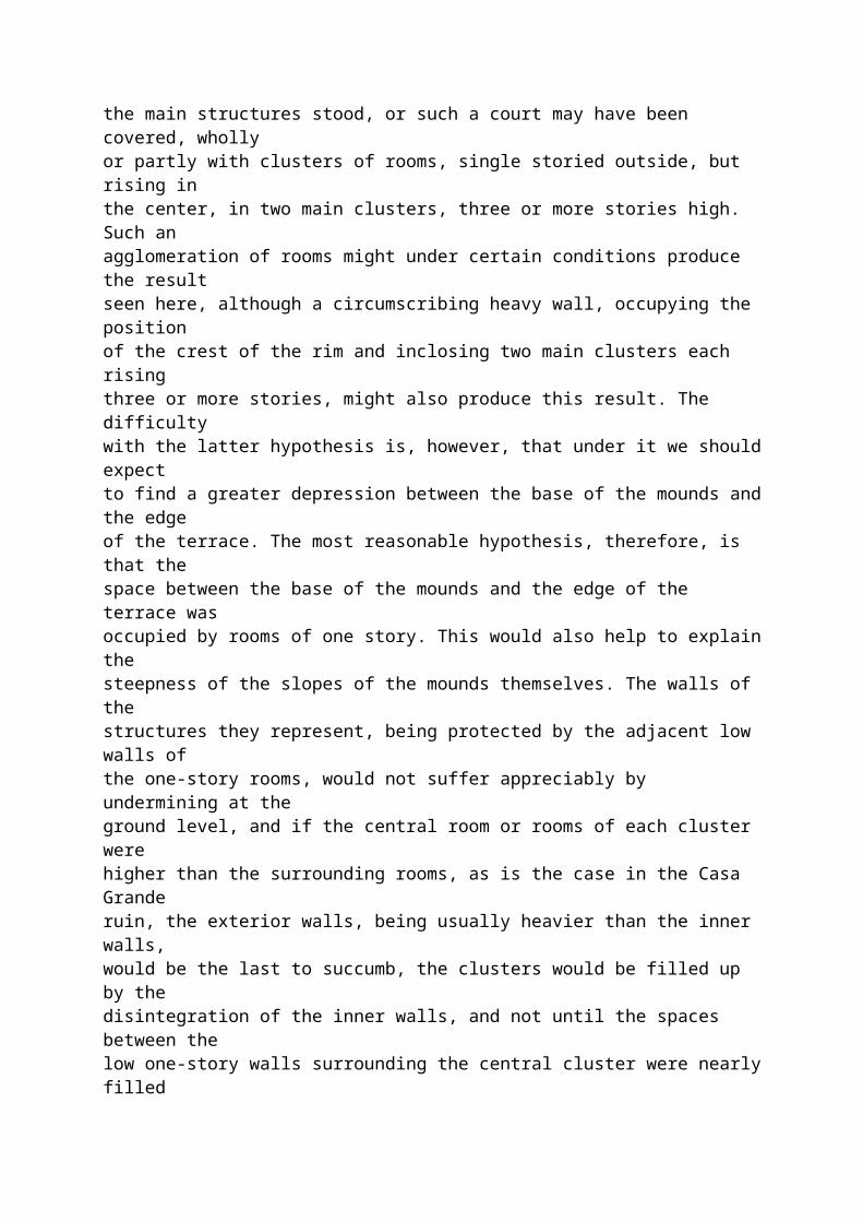
There is an abundance of room between the crest of the rim and the baseof the terrace for a row of single rooms, inclosing a court within whichthe main structures stood, or such a court may have been covered, whollyor partly with clusters of rooms, single storied outside, but rising inthe center, in two main clusters, three or more stories high. Such anagglomeration of rooms might under certain conditions produce the resultseen here, although a circumscribing heavy wall, occupying the positionof the crest of the rim and inclosing two main clusters each risingthree or more stories, might also produce this result. The difficultywith the latter hypothesis is, however, that under it we should expectto find a greater depression between the base of the mounds and the edgeof the terrace. The most reasonable hypothesis, therefore, is that thespace between the base of the mounds and the edge of the terrace wasoccupied by rooms of one story. This would also help to explain thesteepness of the slopes of the mounds themselves. The walls of thestructures they represent, being protected by the adjacent low walls ofthe one-story rooms, would not suffer appreciably by undermining at theground level, and if the central room or rooms of each cluster werehigher than the surrounding rooms, as is the case in the Casa Granderuin, the exterior walls, being usually heavier than the inner walls,would be the last to succumb, the clusters would be filled up by thedisintegration of the inner walls, and not until the spaces between thelow one-story walls surrounding the central cluster were nearly filledup would the pronounced disintegration of the outer walls of thestructures commence. At that period the walls were probably covered andprotected by debris dropping from above, and possibly the profile of themounds was already established, being only slightly modified by surfaceerosion since.
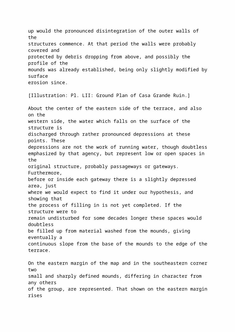
[Illustration: Pl. LII: Ground Plan of Casa Grande Ruin.]
About the center of the eastern side of the terrace, and also on thewestern side, the water which falls on the surface of the structure isdischarged through rather pronounced depressions at these points. Thesedepressions are not the work of running water, though doubtlessemphasized by that agency, but represent low or open spaces in theoriginal structure, probably passageways or gateways. Furthermore,before or inside each gateway there is a slightly depressed area, justwhere we would expect to find it under our hypothesis, and showing thatthe process of filling in is not yet completed. If the structure were toremain undisturbed for some decades longer these spaces would doubtlessbe filled up from material washed from the mounds, giving eventually acontinuous slope from the base of the mounds to the edge of the terrace.
On the eastern margin of the map and in the southeastern corner twosmall and sharply defined mounds, differing in character from any others
of the group, are represented. That shown on the eastern margin risesabout 6 feet and the other about 10 feet above the surrounding level,and both stand out alone, no other remains occurring within a hundredyards in any direction. These mounds seem a thing apart from the otherremains in the group; and it is probable that they represent the latestperiod in the occupancy of this site, or possibly a period subsequent toits final abandonment as a place of residence. Analogous remains occurin conjunction with some large ruins in the north, and there theyrepresent single rooms, parts of the original structure kept in a fairstate of preservation by occasional repairs while the remainder of thevillage was going to ruin, and used as farming outlooks long after thesite was abandoned as a place of residence. As these farming outlookshave been discussed at some length in another paper[1] it is notnecessary here to enlarge upon their function and the important partthey play in Pueblo architecture. If the high mounds in question mark,as supposed, the sites of farming outlooks such as those which are foundin the north, they indicate that the occupancy of the region in whichthey occur was continued after the abandonment of the Casa Grandestructure by the people who built it or by people of similar habits andcustoms.
[Footnote 1: A Study of Pueblo Architecture; 8th Ann. Rep. Bur.Eth., 1891, pp. 86, 227, and elsewhere.]
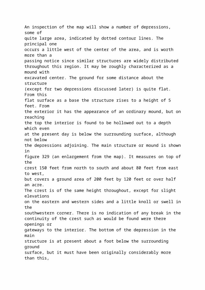
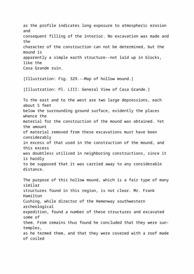
An inspection of the map will show a number of depressions, some ofquite large area, indicated by dotted contour lines. The principal oneoccurs a little west of the center of the area, and is worth more than apassing notice since similar structures are widely distributedthroughout this region. It may be roughly characterized as a mound withexcavated center. The ground for some distance about the structure(except for two depressions discussed later) is quite flat. From thisflat surface as a base the structure rises to a height of 5 feet. Fromthe exterior it has the appearance of an ordinary mound, but on reachingthe top the interior is found to be hollowed out to a depth which evenat the present day is below the surrounding surface, although not belowthe depressions adjoining. The main structure or mound is shown infigure 329 (an enlargement from the map). It measures on top of thecrest 150 feet from north to south and about 80 feet from east to west,but covers a ground area of 200 feet by 120 feet or over half an acre.The crest is of the same height throughout, except for slight elevationson the eastern and western sides and a little knoll or swell in thesouthwestern corner. There is no indication of any break in thecontinuity of the crest such as would be found were there openings orgateways to the interior. The bottom of the depression in the mainstructure is at present about a foot below the surrounding groundsurface, but it must have been originally considerably more than this,as the profile indicates long exposure to atmospheric erosion andconsequent filling of the interior. No excavation was made and thecharacter of the construction can not be determined, but the mound isapparently a simple earth structure--not laid up in blocks, like the
Casa Grande ruin.
[Illustration: Fig. 329.--Map of hollow mound.]
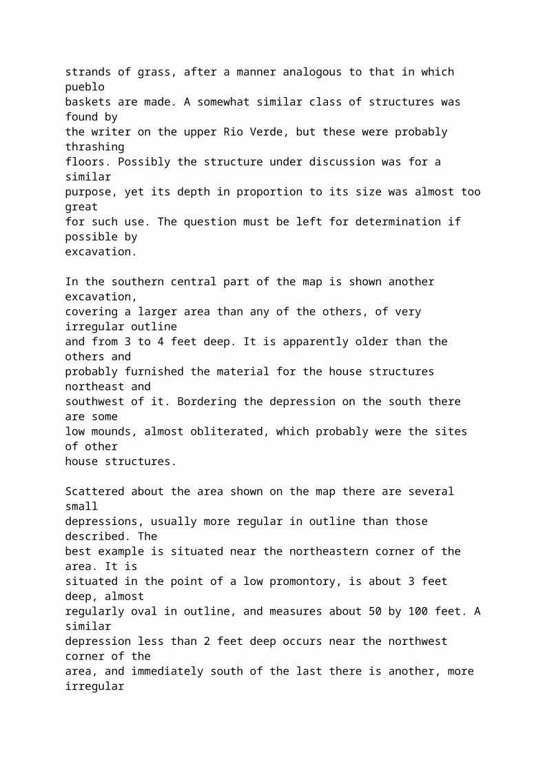
[Illustration: Pl. LIII: General View of Casa Grande.]
To the east and to the west are two large depressions, each about 5 feetbelow the surrounding ground surface, evidently the places whence thematerial for the construction of the mound was obtained. Yet the amountof material removed from these excavations must have been considerablyin excess of that used in the construction of the mound, and this excesswas doubtless utilized in neighboring constructions, since it is hardlyto be supposed that it was carried away to any considerable distance.
The purpose of this hollow mound, which is a fair type of many similarstructures found in this region, is not clear. Mr. Frank HamiltonCushing, while director of the Hemenway southwestern archeologicalexpedition, found a number of these structures and excavated some ofthem. From remains thus found he concluded that they were sun-temples,as he termed them, and that they were covered with a roof made of coiledstrands of grass, after a manner analogous to that in which pueblobaskets are made. A somewhat similar class of structures was found bythe writer on the upper Rio Verde, but these were probably thrashingfloors. Possibly the structure under discussion was for a similarpurpose, yet its depth in proportion to its size was almost too greatfor such use. The question must be left for determination if possible byexcavation.
In the southern central part of the map is shown another excavation,covering a larger area than any of the others, of very irregular outlineand from 3 to 4 feet deep. It is apparently older than the others andprobably furnished the material for the house structures northeast andsouthwest of it. Bordering the depression on the south there are somelow mounds, almost obliterated, which probably were the sites of otherhouse structures.
Scattered about the area shown on the map there are several smalldepressions, usually more regular in outline than those described. Thebest example is situated near the northeastern corner of the area. It issituated in the point of a low promontory, is about 3 feet deep, almostregularly oval in outline, and measures about 50 by 100 feet. A similardepression less than 2 feet deep occurs near the northwest corner of thearea, and immediately south of the last there is another, more irregularin outline, and nearly 3 feet deep. There are also some smalldepressions in the immediate vicinity of the Casa Grande ruin and of themounds north of it.
With a single exception none of these depressions are so situated thatthey could be used as reservoirs for the storage of water collected fromthe surface, and the catchment area of the depressions is so small and
the rate of evaporation in this area so great that their use asreservoirs is out of the question. It is probable that all of thesmaller depressions represent simply sites where building material wasobtained. Possibly the ground at these points furnished more suitablematerial than elsewhere, and, if so, the builders may have taken thetrouble to transport it several hundred yards rather than follow theusual practice of using material within a few feet of the site. Thishypothesis would explain the large size of the depressions, otherwise ananomalous feature.
CASA GRANDE RUIN.
_State of Preservation._
The area occupied by the Casa Grande ruin is insignificant as comparedwith that of the entire group, yet it has attracted the greaterattention because it comprises practically all the walls still standing.There is only one small fragment of wall east of the main structure andanother south of it.
The ruin is especially interesting because it is the best preservedexample now remaining of a type of structure which, there is reason tobelieve, was widely distributed throughout the Gila valley, and which,so far as now known, is not found elsewhere. The conditions under whichpueblo architecture developed in the north were peculiar, and stampedthemselves indelibly on the house structures there found. Here in thesouth there is a radical change in physical environment: even theavailable building material was different, and while it is probable thata systematic investigation of this field will show essentially the sameideas that in the north are worked out in stone, here embodied in adifferent material and doubtless somewhat modified to suit the changedenvironment, yet any general conclusion based on the study of a singleruin would be unsafe. In the present state of knowledge of this field itis not advisable to attempt more than a detailed description, embodying,however, a few inferences, applicable to this ruin only, which seem wellsupported by the evidence obtained.
The Casa Grande ruin is located near the southwestern corner of thegroup, and the ground surface for miles about it in every direction isso flat that from the summit of the walls an immense stretch of countryis brought under view. On the east is the broad valley of Gila riverrising in a great plain to a distant range of mountains. About a mileand a half toward the north a fringe of cottonwood trees marks thecourse of the river, beyond which the plain continues, broken somewhatby hills and buttes, until the view is closed by the Superstitionmountains. On the northwest the valley of Gila river runs into thehorizon, with a few buttes here and there. On the west lies a range ofmountains closing the valley in that direction, while toward thesouthwest and south it extends until in places it meets the horizon,
while in other places it is closed by ranges of mountain blue and mistyin the distance. In an experience of some years among northern ruins,many of them located with special reference to outlook over tillablelands, the writer has found no other ruin so well situated as this.
The character of the site occupied by the ruin indicates that it belongsto a late date if not to the final period in the occupancy of thisregion, a period when by reason of natural increase of numbers, orperhaps aggregation of related gentes, the defense motive no longerdominated the selection of a village site, but reliance was placed onnumbers and character of structures, and the builders felt free toselect a site with reference only to their wants as a horticulturalpeople. This period or stage has been reached by many of the Pueblotribes, although mostly within the historical period; but some of them,the Tusayan for example, are still in a prior stage.
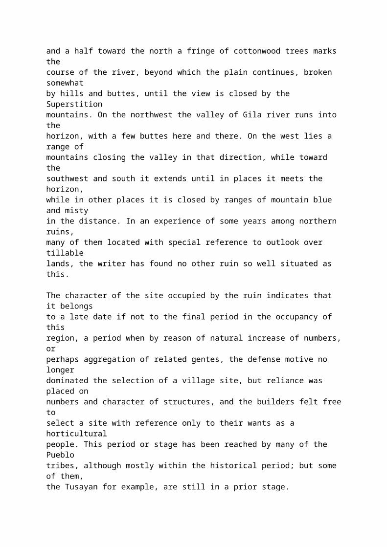
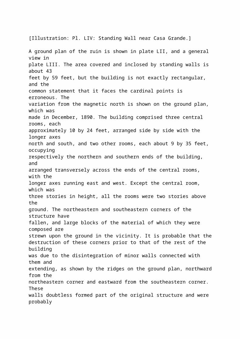
[Illustration: Pl. LIV: Standing Wall near Casa Grande.]
A ground plan of the ruin is shown in plate LII, and a general view inplate LIII. The area covered and inclosed by standing walls is about 43feet by 59 feet, but the building is not exactly rectangular, and thecommon statement that it faces the cardinal points is erroneous. Thevariation from the magnetic north is shown on the ground plan, which wasmade in December, 1890. The building comprised three central rooms, eachapproximately 10 by 24 feet, arranged side by side with the longer axesnorth and south, and two other rooms, each about 9 by 35 feet, occupyingrespectively the northern and southern ends of the building, andarranged transversely across the ends of the central rooms, with thelonger axes running east and west. Except the central room, which wasthree stories in height, all the rooms were two stories above theground. The northeastern and southeastern corners of the structure havefallen, and large blocks of the material of which they were composed arestrewn upon the ground in the vicinity. It is probable that thedestruction of these corners prior to that of the rest of the buildingwas due to the disintegration of minor walls connected with them andextending, as shown by the ridges on the ground plan, northward from thenortheastern corner and eastward from the southeastern corner. Thesewalls doubtless formed part of the original structure and were probablyerected with it; otherwise the corners of the main structure would nothave been torn out or strained enough to fall before the rest of thebuilding was affected.
It is not likely that the main building originally stood alone as atpresent. On the contrary there is every reason to suppose that it wasconnected with other buildings about 75 feet east of it, now marked by abit of standing wall shown on the map (plate LI), and probably also witha small structure about 170 feet south of it, shown in plate LIV. Theseconnections seem to have been by open courts inclosed by walls and notby continuous buildings. The court east of the ruin is well marked bythe contours and seems to have been entered by a gateway or opening at
its southeastern corner.
_Dimensions._
It is probable that the area immediately adjacent to the ruin, and nowcovered by mounds, carried buildings of the same time with the mainstructure and was occupied contemporaneously with it or nearly so. Thisarea, well marked on the map, measures about 400 feet north and south,and 240 feet east and west. It is not rectangular, although the easternand western sides, now marked by long ridges, are roughly parallel. Thenortheastern corner does not conform to a rectangular plan, and thesouthern side is not more than half closed by the low ridge whichextends partly across it. This area is doubtless the one measured in1776, by Padre Font, whose description, was copied by later writers, andwhose measurements were applied by Humboldt and others to the ruinitself. Font gave his measurements as those of a circumscribing wall,and his inference has been adopted by many, in fact most, later writers.A circumscribing wall is an anomalous feature, in the experience of thewriter, and a close inspection of the general map will show that Font'sinference is hardly justified by the condition of the remains today. Itseems more likely that the area in question was covered by groups ofbuildings and rows of rooms, connected by open courts, and forming anoutline sometimes regular for a considerable distance, but more oftenirregular, after the manner of pueblo structures today. The long northand south ridge which forms the southeastern corner of the area, withother ridges extending westward, is quite wide on top, wide enough toaccommodate a single row of rooms of the same width as those of theruin, and it is hardly reasonable to suppose that a wall would be built10 or 12 feet wide when one of 4 feet would serve every purpose to whichit could possibly be put. Furthermore, the supposition of an inclosingwall does not leave any reasonable explanation of the transverse ridgesabove mentioned, nor of the long ridge which runs southward from thesoutheastern corner of the ruin.
The exterior walls rise to a height of from 20 to 25 feet above theground. This height accommodated two stories, but the top of the wall isnow 1 to 2 feet higher than the roof level of the second story. Themiddle room or space was built up three stories high and the walls arenow 28 to 30 feet above the ground level. The tops of the walls, whilerough and much eroded, are approximately level. The exterior surface ofthe walls is rough, as shown in the illustrations, but the interiorwalls of the rooms are finished with a remarkable degree of smoothness,so much so as to attract the attention of everyone who has visited theruin. Mange, who saw the ruin with Padre Font in 1697, says the wallsshine like Puebla pottery, and they still retain this finish whereverthe surface has not cracked off. This fine finish is shown in a numberof illustrations herewith. The walls are not of even thickness. At theground level the exterior wall is from 31/2 to 41/2 feet thick, and in oneplace at the southern end of the eastern wall, is a trifle over 5 feet
thick. The interior walls are from 3 to 4 feet thick at base. At the topthe walls are reduced to about 2 feet thick, partly by setbacks or stepsat the floor levels, partly by exterior batter, the interior wallsurface being approximately vertical. Some writers, noting theinclination of the outer wall surface, and not seeing the interior, haveinferred that the walls leaned considerably away from the perpendicular.This inference has been strengthened, in some cases, by an examinationof the interior, for the inner wall surface, while finely finished, isnot by any means a plane surface, being generally concave in each room;yet a line drawn from floor level to floor level would be very nearlyvertical. The building was constructed by crude methods, thoroughlyaboriginal in character, and there is no uniformity in its measurements.The walls, even in the same room, are not of even thickness, the floorjoists were seldom on a straight line, and measurements made at similarplaces, e.g., the two ends of a room, seldom agree.
[Illustration: Pl. LV: West Front of Casa Grande Ruin.]
A series of precise measurements gives the following results: Outsideeastern wall, at level 3 feet above center of depressed area adjoiningthe ruin on the east, 59 feet; western wall at same level, 59 feet 1inch; northern and southern walls, at same level, 42 and 43 feetrespectively. These measurements are between points formed by theintersection of the wall lines; the northeastern and southeasterncorners having fallen, the actual length of standing wall is less. Atthe level stated the northern wall measures but 34 feet 4 inches, andthe southern wall 36 feet 10 inches. A similar irregularity is found inthe interior measurements of rooms. The middle room is marked by anexceptional departure from regularity in shape and dimensions. Both theeast and west walls are bowed eastward, making the western wall convexand the eastern wall concave in reference to the room.
Precise measurements of the middle room at the second floor level, 8feet above the base previously stated, are as follows: Eastern side, 24feet 81/2 inches; western side, 24 feet 2 inches; northern side, 9 feet 31/2inches; southern side, 9 feet 1 inch. The eastern room is a little moreregular, but there is a difference of 11 inches between the measurementsof the northern and southern ends. A similar difference is found in thewestern room, amounting there to 6 inches. The northern and southernrooms do not afford as good bases for comparison, as a corner is missingin each; but measurements to a point where the interior wall surfaceswould intersect if prolonged, show variations of from 6 inches to afoot. The statement that the ruin exhibits exceptional skill inconstruction on the part of the builders, is not, therefore, supportedby facts.
_Detailed Description._
The Casa Grande ruin is often referred to as an adobe structure. Adobe
construction, if we limit the word to its proper meaning, consists ofthe use of molded brick, dried in the sun but not baked. Adobe, as thusdefined, is very largely used throughout the southwest, more than nineout of ten houses erected by the Mexican population and many of thoseerected by the Pueblo Indians being so constructed; but, in theexperience of the writer, it is never found in the older ruins, althoughseen to a limited extent in ruins known to belong to a period subsequentto the Spanish conquest. Its discovery, therefore, in the Casa Grandewould be important; but no trace of it can be found. The walls arecomposed of huge blocks of earth, 3 to 5 feet long, 2 feet high, and 3to 4 feet thick. These blocks were not molded and placed in situ, butwere manufactured in place. The method adopted was probably the erectionof a framework of canes or light poles, woven with reeds or grass,forming two parallel surfaces or planes, some 3 or 4 feet apart andabout 5 feet long. Into this open box or trough was rammed clayey earthobtained from the immediate vicinity and mixed with water to a heavypaste. When the mass was sufficiently dry, the framework was moved alongthe wall and the operation repeated. This is the typical pise orrammed-earth construction, and in the hands of skilled workmen itsuffices for the construction of quite elaborate buildings. As hereused, however, the appliances were rude and the workmen unskilled. Aninspection of the illustrations herewith, especially of plate LV,showing the western wall of the ruin, will indicate clearly how thiswork was done. The horizontal lines, marking what may be called courses,are very well defined, and, while the vertical joints are not apparentin the illustration, a close inspection of the wall itself shows them.It will be noticed that the builders were unable to keep straightcourses, and that occasional thin courses were put in to bring the wallup to a general level. This is even more noticeable in other parts ofthe ruin. It is probable that as the walls rose the exterior surface wassmoothed with the hand or with some suitable implement, but it was notcarefully finished like the interior, nor was it treated like the latterwith a specially prepared material. The material employed for the wallswas admirably suited for the purpose, being when dry almost as hard assandstone and practically indestructible. The manner in which such wallsdisintegrate under atmospheric influences has already been set forth indetail in this report. An inhabited structure with walls like thesewould last indefinitely, provided occupancy continued and a few slightrepairs, which would accompany occupancy, were made at the conclusion ofeach rainy season. When abandoned, however, sapping at the ground levelwould commence, and would in time level all the walls; yet in the twocenturies which have elapsed since Padre Kino's visit--and the CasaGrande was then a ruin--there has been but little destruction, thedamage done by relic hunters in the last twenty years being in fact muchgreater than that wrought by the elements in the preceding twocenturies. The relic hunters seem to have had a craze for wood, as thelintels of openings and even the stumps of floor joists have been tornout and carried away. The writer has been reliably informed that as lateas twenty years ago a portion of the floor or roof in one of the roomswas still in place, but at the present day nothing is left of the floors
except marks on the vertical walls, and a few stumps of floor joists,deeply imbedded in the walls, and so high that they can not be seen fromthe ground.
[Illustration: Pl. LVI: Interior Wall of Casa Grande Ruin.]
The floors of the rooms, which were also the roofs of the rooms below,were of the ordinary pueblo type, employed also today by the Americanand Mexican population of this region. In the Casa Grande ruin a seriesof light joists or heavy poles was laid across the shorter axis of theroom at the time the walls were erected; these poles were 3 to 6 inchesin diameter, not selected or laid with unusual care, as the holes in theside walls which mark the places they occupied are seldom in a straightline, and their shape often indicates that the poles were quite crooked.Better executed examples of the same construction are often found innorthern ruins. Over the primary series of joists was placed a layer oflight poles, 11/2 to 2 inches in diameter, and over these reeds and coarsegrass were spread. The prints of the light poles can still be seen onthe walls. The floor or roof was then finished with a heavy coating ofclay, trodden down solid and smoothed to a level. A number of blocks ofthis final floor finish, bearing the impress of the grass and reeds,were found in the middle room. There is usually a setback in the wall atthe floor level, but this practice was not followed in all the rooms.
The position of the floor is well marked in all cases by holes in thewall, into which beams projected sometimes to a depth of 3 feet, and bya peculiar roughness of the wall. Plate LVI shows two floor levels, bothset back slightly and the upper one strongly marked by the roughnessmentioned. This roughness apparently marks the thickness of the floor insome cases, yet in others it is much too thick for a floor and must havehad some other purpose. The relation of these marks to the beam holessuggests that in some cases there was a low and probably narrow bencharound two or more sides of the room; such benches are often found inthe present Pueblo villages.
The walls of the northern room are fairly well preserved, except in thenortheastern corner, which has fallen. The principal floor beams were ofnecessity laid north and south, across the shorter axis of the room,while the secondary series of poles, 11/2 inches in diameter, have lefttheir impression in the eastern and western walls. There is no setbackin the northern wall at the first floor level, though there is a veryslight one in the southern wall; none appears in the eastern and westernwalls. Yet in the second roof level there is a double setback of 9 and 5inches in the western wall, and the northern wall has a setback of 9inches, and the top of the wall still shows the position of nearly allthe roof timbers. This suggests--and the suggestion is supported byother facts to be mentioned later--that the northern room was addedafter the completion of the rest of the edifice.
The second roof or third floor level, the present top of the wall, has a
decided pitch outward, amounting to nearly 5 inches. Furthermore, theoutside of the northern wall of the middle room, above the second rooflevel of the northern room, is very much eroded. This indicates that thenorthern room never had a greater height than two stories, but probablythe walls were crowned with low parapets. In this connection it may bestated that a calculation of the amount of debris within the buildingand for a distance of 10 feet about it in every direction, the interiorfloor level being determined by excavation, showed an amount of materialwhich, added to the walls, would raise them less than 3 feet; in otherwords, the present height of the walls is very nearly the maximumheight.
Subsequent to this examination the ruin was cleared out by contractorsfor the Government in carrying out a plan for the repair andpreservation of the ruin, and it was reported that in one of the rooms afloor level below that previously determined was found, making anunderground story or cellar. This would but slightly modify theforegoing conclusion, as the additional debris would raise the wallsless than a foot, and in the calculation no account was taken ofmaterial removed from the surface of the walls.
In support of the hypothesis that the second roof level of the northernroom was the top roof, it may be stated that there is no trace of anopening in the walls above that level, except on the western side. Therewas a narrow opening in the western corner, but so well filled that itis hardly perceptible. Doubtless it formed a niche or opening in theparapet.
The southern wall on the first roof level still preserves very clear anddistinct impressions of the rushes which were used in the constructionof the roof. In some cases these impressions occur 3 inches above thetop of the floor beams, in others directly above them, showing that thesecondary series of poles was very irregularly placed. In the easternand western walls the impressions of rushes are also clear, but therethey are parallel with the wall surface. The rushes were about thethickness of a pencil.
The floor joists were 3 to 4 inches in diameter, and as a rule projectedinto the wall but 5 to 8 inches. In some places in the northern wall,however, they extended into the masonry as much as 3 feet 3 inches. Thebeams were doubtless cut by guess, at the place where trees of therequisite size were found, according to the method employed by thePueblo Indians today, and if, as supposed, the northern room was builtafter the rest of the structure, the excess in length would necessarilybe found in the northern wall.
In the roof construction previously described rushes or canes formed thethird member, and in the northern room the wall is rough immediatelyabove the impressions of rushes, and projects 8 to 12 inches. Thisfeature is well marked; it may be a remnant of the clay covering of
floor or roof, but it is almost too thick for that and possibly marksthe position of a low bench, as previously suggested. The bottoms of theopenings come just to or a trifle above the top of this marking.
[Illustration: Pl. LVII: Blocked Opening in West Wall.]
The walls of the western room were smoothly finished and the finish iswell preserved, but here, as in the northern room, the exterior wall ofthe middle room was not finished above the second roof level, and thereis no doubt that two stories above the ground were the maximum height ofthe western rooms, excluding the parapet. The eastern wall presents amarked double convexity while the western wall is comparatively straightin a horizontal line, but markedly concave vertically above the firstroof level. Below this level it is straight. The floor beams were from 3to 6 inches in diameter. The marks in the eastern wall show that thebeams projected into it to a nearly uniform depth of 1 foot 4 inches. Inthe western wall, however, the depth varies from 1 to 3 feet. The beamswhich entered the eastern wall were very irregularly placed, the linerising in the center some 3 or 4 inches. The beams of the second rooflevel show the same irregularity and in the same place; possibly thiswas done to correct a level, for the same feature is repeated in theeastern room.
The walls of the southern room are perhaps better finished and less wellconstructed than any others in the building. The beam holes in thesouthern wall are regular, those in the northern wall less so. The beamsused averaged a little smaller than those in the other rooms, and thereis no trace whatever in the overhanging wall of the use of rushes orcanes in the construction of the roof above. The walls departconsiderably from vertical plane surfaces; the southern wall inclinesfully 12 inches inward, while in the northeastern corner the side of adoorway projects fully 3 inches into the room. The broken condition ofthe southern wall indicates carelessness in construction. The weakestpoint in pise construction is of course the framing around openings. Inthe southern wall the openings, being doubtless the first to give way,are now almost completely obliterated. In the center of the wall therewere two openings, one above the other, but not a trace of lintels nowremains, and the eastern half of the wall now stands clear from otherwalls. Probably there was also an opening near the southwestern cornerof the room, but the lintels giving way the wall above fell down and, asshown on the ground plan (plate LII), filled up the opening. This couldhappen only with exceptionally light lintels and exceptionally badconstruction of walls; one of the large blocks, before described ascomposing the wall, must have rested directly above the opening, whichwas practically the same size as the block.
The walls of the eastern room were well finished, and, except thewestern wall, in fairly good preservation. The floor beams were notplaced in a straight line, but rise slightly near the middle, as notedabove. The finish of some of the openings suggests that the floor was
but 3 or 4 inches above the beams, and that the roughened surface,already mentioned, was not part of it. The northern wall of this roomseems to have run through to the outside, on the east, as though at onetime it formed the exterior wall of the structure; and the eastern wallof the building north of this room is separated from the rest of thewall by a wide crack, as though it had been built against a smoothsurface. The western wall of this room shows clearly that in theconstruction of the building the floor beams were laid on the tops ofthe walls, and that the intervening spaces were filled with small lumpsof material up to a level with or a little above the upper surface ofthe beams, the regular construction with large blocks being thenresumed.
In the middle room many blocks bearing the imprint of grass and rusheswere found, and the rough marking of the walls just above the floorbeams is covered in places in this room with masonry composed of thesegrass marked blocks projecting some distance into the room, indicatingthat in this room at least they mark the position of a bench. Theseblocks occupy the whole thickness of the setback at the second rooflevel--perhaps an indication that the upper story was added after thebuilding was occupied.
_Openings._
The Casa Grande was well provided with doorways and other openingsarranged in pairs one above the other. There were doorways from eachroom into each adjoining room, except that the middle room was enteredonly from the east. Some of the openings were not used and were closedwith blocks of solid masonry built into them long prior to the finalabandonment of the ruin.
The middle room had three doorways, one above the other, all openingeastward. The lowest doorway opened directly on the floor level, and was2 feet wide, with vertical sides. Its height could not be determined, asthe top was completely broken away and merged with the opening above,but the bottom, which is also the floor level, is 6 feet 9 inches belowthe level of the first roof beams. The doorway of the second story ispreserved only on the northern side. Its bottom, still easilydistinguishable, is 1 foot 6 inches above the bottom of the floor beams.It was not over 2 feet wide and was about 4 feet high. The upper doorwayis still well preserved, except that the lintels are gone. It is aboutthree inches narrower at the top than at the bottom and about 4 feethigh.
In addition to its three doorways, all in the eastern wall, the middletier of rooms was well provided with niches and holes in the walls, someof them doubtless utilized as outlooks. On the left of the upper doorwayare two holes, a foot apart, about 4 inches in diameter, and smoothlyfinished. Almost directly above these some 3 feet, and about 2 feet
higher than the top of the door, there are two similar holes. Near thesouthern end of the room in the same wall there is another round openinga trifle larger and about 41/2 feet above the floor level. In the westernwall there are two similar openings, and there is one each in thenorthern and southern walls. All these openings are circular, of smalldiameter, and are in the upper or third story, as shown on theelevations herewith, figure 330. The frequency of openings in the upperor third story and their absence on lower levels, except the speciallyarranged openings described later, supports the hypothesis that none ofthe rooms except the middle one were ever more than two stories high andthat the wall remains above the second roof level represent a lowparapet.
[Illustration: Pl. LVIII: Square Opening in South Room.]
In the second story, or middle room of the middle tier, there were noopenings except the doorway in the eastern wall and two small orificesin the western wall. In the middle of this wall there is a niche about18 inches below the roof, and a foot below this is a round-corneredopening measuring about 7 by 8 inches extending through the wall. Thisopening was on a level with another in the western wall of the westernroom, and commanded a far-reaching though contracted view toward thewest. Below and a little northward is a similar though somewhat largeropening corresponding to an opening in the western wall of the westernroom.
[Illustration: Fig. 330.--Elevations of walls, middle room.]
The upper doorway in the western wall of the western room is much brokenout, but the top can still be traced. It was 4 feet 51/2 inches in heightand 1 foot 11 inches wide at top. The opening was blocked by solidmasonry built into it and completely filling it up to within 10 inchesof the top. This upper space, which is on a level with the upper hole inthe middle room, seems to have been purposely left to allow an outlookfrom that room. The filling block is level on top and flush with thewall inside and out. At a height of 12 inches above the lower edge ofthe floor beams below it, and perhaps 3 inches above the floor, is thelower edge of a roughly square opening a foot across, cut out from theblock itself and inclined slightly downward toward the exterior. It wasplastered and smoothly finished. This opening corresponds to the one inthe middle room already described. This filling block, with the orificeunder discussion, is shown in figure 330, and in detail in plate LVII.
The lower doorway, shown in figure 330, is much broken out, and althoughnow but 2 feet 11/2 inches wide at its narrowest part, no trace of theoriginal surface remains on the northern side. The opening was 4 feet 61/2inches high and probably less than 2 feet wide, with vertical sides.
In the western wall of the southern room there was but one opening. Thisis about 9 inches square, finished smoothly, and occurs in the upper
room, about 6 feet 5 inches above the floor. It is shown in plate LVIII.The doorway between this room and the western room was smoothly finishedand is in good order except the top, which is entirely gone. It wascovered with double lintels made of poles 2 to 4 inches in diameter, thelower series about 3 inches above the top of the door. The opening wasoriginally filled in like that described above, leaving only 8 or 10inches of the upper part open. The lower part of the block was piercedby a square hole, like that in the western room, but this has weatheredor been broken out and the block has slipped down, so that now its topis 1 foot 51/2 inches below what was formerly the top of the opening. Thetop of the filling block is still smooth and finished and shows acrossits entire width a series of prints probably of flat sticks about aninch and a half wide, though, possibly these are marks of some finishingtool. The marks run north and south.
The opening below the one just described was so much filled up at thetime of examination that none of its features could be determined,except that it was bridged by two tiers of sticks of the usual size aslintels. The subsequent excavation before referred to, however,apparently disclosed an opening similar to the one described, and, likeit, filled nearly to the top with a large block.
A little west of the middle of the northern wall there are three niches,arranged side by side and about 61/2 feet above the first roof beams. Theniches are 10 inches high, a foot wide, and about a foot deep, and areabout 8 inches apart. They are smoothly finished and plastered, but wereroughly made.
The eastern opening in the northern wall, opening into the east room, iswell preserved except the top, which is missing. It measured 4 feet 21/2inches in height and 1 foot 11 inches wide at the bottom, the top beingnearly an inch narrower. It carried two tiers of lintels of medium size.
The gap in the southern wall of the southern room, shown in the plan,though now open from the ground up, represents the location of twodoorways, one above the other. Remains of both of these can still beseen on the ends of the walls. No measurements can be obtained. Thelarge fallen block near the southwestern corner of the room, whichundoubtedly slipped down from above, shows a finished surface at theground level inside, but above it no trace of an opening can be seen,possibly because the ends of the walls above are much eroded.
[Illustration: Pl. LIX: Remains of Lintels.]
The upper opening in the eastern wall of the eastern room was apparentlycapped with a single lintel composed of five sticks 4 to 6 inches indiameter laid level on the top of a course of masonry. The bottom of theopening is filled either with washed-down material or with the remainsof a block such as that previously described. This opening is the mostirregular one in the building, the top being nearly 4 inches narrower
than the bottom, but the northern side of the opening is vertical, thesouthern side only being inclined inward. The opening was 4 feet 11inches high and 1 foot 81/2 inches wide at the bottom. The openingimmediately below that described, which was the ground floor entrancefrom the east, is so much broken out that no evidence remains of itssize and character. There appears to have been only one row of lintelpoles.
The eastern opening in the southern wall of the northern room is wellpreserved, the lintels having been torn out by relic hunters withoutmuch destruction of the surrounding masonry. It was neatly finished, andits bottom, was probably a little above the first roof level. The edgesof the openings were made straight with flat sticks, either used asimplements or incorporated into the structure, and forming almostperfectly straight edges. Marks of the same method of construction orfinish are apparent in all the other openings, but the remains are notso well preserved as in this instance. Possibly the immediate lintels ofopenings were formed of thin flat sticks, as the lintel poles are oftensome inches above the top of the opening. In this opening the supportinglintel was formed of a number of poles 2 to 4 inches in diameter,irregularly placed, sometimes two or three in vertical series with verylittle filling between them. This construction has been characterized asa Norman arch. The opening was originally 1 foot 11 inches at the topand 4 feet 6 inches high. The bottom is 11/2 inches wider than the top.
The upper opening in the western end of the southern wall is much likethat just described. A small fragment of masonry above the lintelremains, and this is within a quarter of an inch of the top of theopening. Above the opening there was a series of rough lintel poles, 3to 5 inches in diameter, arranged in three tiers with 4 to 6 inches offilling between them. Prints of these sticks are left in the wall andshow that some of them were quite crooked. Probably they were ofmesquite, obtained from the immediate vicinity. The edges of theopenings were finished with flat sticks, like those described, and itsbottom was 6 inches to a foot above the floor. The height of the openingwas 4 feet 3 inches and its width at the top 2 feet, at the bottom 2feet 11/2 inches.
The opening immediately below the last described is filled with debristo the level of the lintel. Above this, however, there is a series ofthree tiers of sticks with 6 to 8 inches of masonry between themvertically, sometimes laid side by side, sometimes separated by a footof masonry. Some of these lintel poles, as well as those of the openingabove it, extend 3 feet into the wall, others only a few inches. Thelower sides or bottoms of the holes are washed with pink clay, the samematerial used for surfacing the interior walls. Perhaps this was merelythe wetting used to make succeeding courses of clay stick better. Thisopening is shown in plate LIX.
Near the middle of the northern wall there are two openings, one above
the other. The upper opening was finished in the same manner as thosealready described. But two tiers of poles show above it, though the topis well preserved, and another tier may be buried in the wall. There areindications that the opening was closed by a block about 2 feet thickand flush with the outside. The height of the opening was 4 feet 5inches, width at top 1 foot 41/2 inches, and at the bottom 1 foot 10inches. It narrows a little from north to south.
The lower opening is so much broken out that little remains to show itscharacter. There is a suggestion that the opening was only 2 feet high,and there were probably three tiers of lintels above the opening, thetop of which was 21/2 feet below the roof beams, but the evidence is notso clear as in the other instances.
In the middle of the western wall, at a height of 5 feet 8 inches abovethe first roof level, there is a large, roughly circular opening orwindow, 14 inches in diameter. This is shown in plate LX. It is smoothlyfinished, and enlarges, slightly, outward.
CONCLUSIONS.
As before stated, any conclusions drawn from a study of the Casa Grandeitself, and not checked by examination of other similar or analogousruins, can not be considered as firmly established, yet they have asuggestive value.
From the character of the remains it seems probable that the site of theruins here designated as the Casa Grande group was occupied a long time,not as a whole, but piecemeal as it were, one part being occupied andabandoned while some other part was being built up, and that this ebband flow of population through many generations reached its final periodin the occupation of the structure here termed the Casa Grande ruin. Itis probable that this structure did not exist at the time the site wasfirst occupied, and still more probable that all or nearly all the othersites were abandoned for some time before the structure now called theCasa Grande was erected. It is also probable that after the abandonmentof the Casa Grande the ground about it was still worked by its formerpopulation, who temporarily occupied, during the horticultural season,farming outlooks located near it.
[Illustration: Pl. LX: Circular Opening in North Room.]
The methods employed in the construction of the buildings of the CasaGrande were thoroughly aboriginal and characteristically rude inapplication. A fair degree of adaptability to purpose and environment isseen, indicating that the Casa Grande was one, and not the first,
building of a series constructed by the people who erected it and bytheir ancestors, but the degree of skill exhibited and amount ofingenuity shown in overcoming difficulties do not compare with thatfound in many northern ruins. As architects, the inhabitants of the CasaGrande did not occupy the first rank among pueblo-builders.
It is probable that the Casa Grande ruin as we see it today shows verynearly the full height of the structure as it stood when it wasabandoned. The middle tier of rooms rose to a height of three stories;the others were but two stories high. It is also probable that thebuilding was enlarged after being once completed and occupied. At onetime it probably consisted of four rooms on the ground plan, each twostories high. The northern tier, of rooms was added afterward, andprobably also the third room in the central tier.
The Casa Grande was undoubtedly built and occupied by a branch of thePueblo race, or by an allied people. Who these people were it isimpossible to determine finally from the examination of one ruin, butall the evidence at hand suggests that they were the ancestors of thepresent Pima Indians, now found in the vicinity and known to haveformerly been a pueblo-building tribe. This conclusion is supported bythe Pima traditions, as collected by Mr. Bandelier, who is intimatelyacquainted with the documentary history of the southwest, and whoseknowledge of the Pima traditions is perhaps greater than that of anyoneelse now living. In his various writings he hints at this connection,and in one place he declares explicitly that the Casa Grande is a Pimastructure. None of the internal evidence of the ruin is at variance withthis conclusion. On the contrary, the scanty evidence is in accord withthe hypothesis that the Casa Grande was erected and occupied by theancestors of the Pima Indians.
INDEX
Adobe defined 309Age of Casa Grande 299, 318
Bandelier, A. F., Description of Casa Grande by 297Pima Casa-Grande tradition by 319Bartlett, J. R., cited 296, 297
Casa Grande, Masonry of 306Chichilticale, Description of 295Cushing, F. H., Allusion by, to Casa Grande 297southwestern sun-temples 305
Defensive motive of Casa Grande 307
Depressions, Artificial, at Casa Grande 303Dimensions of Casa Grande 307Doorways in Casa Grande 314
Emory, W. H., Visit of, to Casa Grande 297
Fewkes, J. W., Description of Casa Grande by 298Floors of Casa Grande 311Font, Pedro, Account of Casa Grande by 296on dimensions of Casa Grande 307
Humboldt, A. von, on dimensions of Casa Grande 308
Johnston, Capt., Visit of to Casa Grande 297
Kino, Eusebio, Visit of, to Casa Grande 296
Lintels in Casa Grande 317
Mange, Juan M., on Casa Grande 296Masonry of Casa Grande 309Mindeleff, V., on pueblo farming outlooks 303Mound surrounding Casa Grande 300
Photographs of Casa Grande compared 300Pima, Casa Grande built by the 319Populationof pueblos 300Casa Grande 300
Rooms of Casa Grande, Dimensions of 307
Site of Casa Grande, Character of 306
Ternaux-Compans, Translation of Castaneda by 296Thrashing Floors in Verde valley 305Tradition of Pima, of Casa Grande 319
Walls of Casa Grande 308, 300, 313Window-Openings in Casa Grande 314Woodwork of Casa Grande 310, 312, 313
* * * * *
[Errata:
...no English translation has yet been published.)_closing parenthesis missing in original_
Bancroft gives a partial translation in op. cit., p. 623, note,
_original reads_ p. 623, note),
thrashing floors_spelling as in original (text and Index)_
(Index)Casa Grande / Masonry of 306_text reads_ 360]
END
This etext was retrieved by ftp from ibiblio.org/pub/docs/books/gutenbergIt is also available from www.ibiblio.org/gutenberg
Produced by Louise Hope, Carlo Traverso, and the OnlineDistributed Proofreading Team at http://www.pgdp.net (Thisfile was produced from images generously made availableby the Bibliotheque nationale de France (BnF/Gallica) athttp://gallica.bnf.fr)