Capel Water Reserve · Capel Water Reserve drinking water source protection plan WRP no. 188...
62
Water resource protection series Report WRP 188 May 2019 drinking water source protection plan Capel Water Reserve Capel town water supply
Transcript of Capel Water Reserve · Capel Water Reserve drinking water source protection plan WRP no. 188...
Water resource protection seriesReport WRP 188May 2019
drinking water source protection plan
Capel Water Reserve
Capel town water supply

Capel Water Reserve drinking water source protection plan
Capel town water supply
Department of Water and Environmental Regulation
Water resource protection series
Report no. 188
May 2019
Department of Water and Environmental Regulation
Prime House 8 Davidson Terrace
Joondalup Western Australia 6027
Telephone +61 8 6364 7000
Facsimile +61 8 6364 7001
National relay service 13 36 77
www.dwer.wa.gov.au
© Government of Western Australia
May 2019
This work is copyright. You may download, display, print and reproduce
this material in unaltered form only (retaining this notice) for your personal, non-commercial
use or use within your organisation. Apart from any use as permitted under the Copyright Act
1968, all other rights are reserved. Requests and inquiries concerning reproduction and
rights should be addressed to the Department of Water and Environmental Regulation.
ISSN 1835-3924 (online)
Acknowledgements
The Department of Water and Environmental Regulation would like to thank the following for
their contribution to this publication: Justin King, Brendan Kelly, Andrew Watson, Stephen
Watson (Department of Water and Environmental Regulation), Hilary Manikkathiagarajah
(Water Corporation).
For more information about this report, contact:
Water Source Protection Planning on +61 8 6364 7600 or [email protected].
Cover photograph: Capel aerial photograph
Disclaimer
This document has been published by the Department of Water and Environmental
Regulation. Any representation, statement, opinion or advice expressed or implied in this
publication is made in good faith and on the basis that the Department of Water and
Environmental Regulation and its employees are not liable for any damage or loss
whatsoever which may occur as a result of action taken or not taken, as the case may be in
respect of any representation, statement, opinion or advice referred to herein. Professional
advice should be obtained before applying the information contained in this document to
particular circumstances.
This publication is available at our website www.dwer.wa.gov.au or for those with special needs it can be made available in alternative formats such as audio, large print, or Braille.
Capel Water Reserve drinking water source protection plan WRP no. 188
Department of Water and Environmental Regulation iii
Contents Contents ..................................................................................................................... iii
Summary ..................................................................................................................... v
1 Overview ................................................................................................................. 1
1.1 The drinking water supply system ...................................................................................... 1
1.2 Water management ............................................................................................................ 1 1.2.1 Licence to take water .............................................................................................................. 1 1.2.2 Water planning and future water needs .................................................................................. 2
1.3 Characteristics of the catchment ........................................................................................ 2 1.3.1 Physical environment .............................................................................................................. 2 1.3.2 Climate.................................................................................................................................... 2 1.3.3 Hydrogeology .......................................................................................................................... 2
1.4 How is this drinking water source currently protected? ...................................................... 3
1.5 Other water management information ................................................................................ 3 1.5.1 Other groundwater bores in the area ...................................................................................... 3
1.6 Aboriginal sites of significance and Native title claims ....................................................... 4
2 Common contamination risks .................................................................................. 5
2.1 Microbiological risks ........................................................................................................... 5
2.2 Physical risks ...................................................................................................................... 6
2.3 Chemical risks .................................................................................................................... 7
3 Contamination risks in this drinking water source .................................................... 8
3.1 Water quality ....................................................................................................................... 8
3.2 Land uses and activities ..................................................................................................... 8 3.2.1 Special use (industrial) area ................................................................................................... 8 3.2.2 Water Corporation compound ................................................................................................. 9 3.2.3 Residential area ...................................................................................................................... 9 3.2.4 Capel River and foreshore ...................................................................................................... 9 3.2.5 Roads and vehicles .............................................................................................................. 10 3.2.6 Contaminated sites ............................................................................................................... 10
3.3 Possible future contamination risks .................................................................................. 10 3.3.1 Redevelopment of the Special use (industrial) area ............................................................. 10 3.3.2 Mining ................................................................................................................................... 11
4 Protecting your drinking water source ................................................................... 12
4.1 Proclaiming public drinking water source areas ............................................................... 12
4.2 Defining the Capel Water Reserve boundary ................................................................... 12
4.3 Defining priority areas ....................................................................................................... 13
4.4 Defining protection zones ................................................................................................. 13
4.5 Planning for future land uses ............................................................................................ 14
4.6 Using best management practices ................................................................................... 14
4.7 Enforcing by-laws and surveying the area ....................................................................... 15
4.8 Responding to emergencies ............................................................................................. 15
4.9 Implementing this plan ...................................................................................................... 15
5 Recommendations ................................................................................................ 16
Appendices ................................................................................................................ 17
Appendix A — Figures................................................................................................................ 17

WRP no. 188 Capel Water Reserve drinking water source protection plan
____________________________________________________________________________________________________________
iv Department of Water and Environmental Regulation
Appendix B — Water quality data .............................................................................................. 23
Appendix C — Land use, potential water quality risks and recommended protection .............. 26
Appendix D — Photographs ....................................................................................................... 33
Appendix E — Summary of submissions ................................................................................... 36
Appendix F — How do we protect public drinking water source areas? ................................... 37
Appendix G — Understanding risks to drinking water quality .................................................... 41
List of shortened forms .............................................................................................. 43
Glossary .................................................................................................................... 45
References ................................................................................................................ 50
Further reading .......................................................................................................... 52
Tables
Table 1 Key information about the Capel Water Reserve ........................................... vi Table 2 Aesthetic detections for Capel bore field ...................................................... 24 Table 3 Health-related detections for Capel bore field ............................................... 25
Capel Water Reserve drinking water source protection plan WRP no. 188
Department of Water and Environmental Regulation v
Summary
Capel is approximately 200 km south of Perth on the Capel River (Figure A1),
providing the economic and administrative centre for the Shire of Capel (Shire of
Capel 2017).
Capel has a resident population of around 2500 (ABS 2016) and has experienced
residential growth and urbanisation in recent years. Activities within and around
Capel include agriculture such as beef and dairy farming, light industry, service and
commercial as well as mineral sand mining.
The Water Corporation supplies Capel with reliable, high quality drinking water from
the Yarragadee aquifer. This is Capel’s sole supply of drinking water and it is sourced
locally from deep bores within the Capel town site. The Water Corporation has
recently constructed two new bores (1/16 and 2/16) within the Capel bore field to
replace two ageing bores constructed in the 1970s (1/71 and 1/72). The Capel bores
abstract water from 130 to 180 m below ground level.
Normally, the Yarragadee aquifer is confined by a layer of rock and is considered
confined at a regional level. However, at Capel, the layer of rock is absent and the
aquifer is considered locally to be semi-confined. This means that contamination from
surface land uses near the bore field has the potential to leach down into Capel’s
drinking water source.
This plan proposes to constitute a Capel Water Reserve over a 300 m radius from
the Capel bore field to protect the bore area that is most vulnerable to water quality
contamination risks (Figure A2).
The Department of Water and Environmental Regulation recommends the following
strategies to protect water quality within the proposed Capel Water Reserve:
proclaim the Capel Water Reserve under the Country Areas Water Supply Act
1947
establish a 300 m wellhead protection zone (WHPZ) over the entire water
reserve
assign priority 1 (P1) areas to all Crown, state and Water Corporation land
(figures A2 and A3)
assign priority 3 (P3) areas to all private land (Figure A2)
identify the Capel Water Reserve in the Capel local planning scheme
connect the residential area to deep sewerage if the area is further subdivided,
or use aerobic treatment units if deep sewerage is not feasible
implement best management practices within the existing special use
(industrial) area to help protect the drinking water source.
This plan is consistent with the Australian drinking water guidelines (ADWG)
(NHMRC & NRMMC 2011) and State planning policy no. 2.7: Public drinking water
source policy.
We have prepared this document in consultation with key stakeholders, including
land owners, the Water Corporation and the Shire of Capel.

WRP no. 188 Capel Water Reserve drinking water source protection plan
vi Department of Water and Environmental Regulation
The following table shows important information about the Capel Water Reserve.
Table 1 Key information about the Capel Water Reserve
Local government authority Shire of Capel
Locations supplied Capel
Aquifer type Locally semi-confined Yarragadee aquifer
Licensed abstraction 450 000 kL/year (licence 62154)
Number of bores Four (two to be decommissioned)
Bore name and GPS
coordinates
1/71 (E 367 145, N 6 286 332) – reaching the end of its
functional life
1/72 (E 367 090, N 6 286 352) – offline and capped
1/16 (E 367 147, N 6 286 351)
2/16 (E 367 152, N 6 286 321)
Date of bore completion 1/71 – 1971
1/72 – 1972
1/16 – 2016
2/16 – 2016
Consultation Shire of Capel, Water Corporation, South West
Aboriginal Land and Sea Council, Western Australian
Local Government Association, private landowners,
mining tenement holder, Department of Health,
Department of Planning, Lands and Heritage,
Department of Mines, Industry Regulation and Safety
Drinking water source
protection reports
2018 – Capel Water Reserve drinking water source
protection plan (this document)
Proclamation status Proclamation will be progressed under the Country
Areas Water Supply Act 1947 when this plan is finalised.
Reference documents Australian drinking water guidelines (NHMRC & NRMMC
2011)
State planning policy no. 2.7: Public drinking water
source policy (Western Australian Planning Commission
2003)

Capel Water Reserve drinking water source protection plan WRP no. 188
Department of Water and Environmental Regulation vii
South West groundwater areas allocation plan
(Department of Water and Environmental Regulation
2009)
Capel River action plan (Geographe Catchment Council
and the Capel Land Conservation District
Committee1999)

Capel Water Reserve drinking water source protection plan WRP no. 188
Department of Water and Environmental Regulation 1
1 Overview
1.1 The drinking water supply system
Capel’s drinking water is sourced from a Water Corporation bore compound within
the town (Figure A1). Two production bores (1/71 and 1/72) have supplied Capel’s
drinking water since the 1970s (Figure A3). These bores are screened in the upper
Yarragadee aquifer between 160 and 180 m deep. Production bore 1/72 recently
collapsed and has been permanently taken offline and sealed (Figure D1), while
production bore 1/71 is still in use but nearing the end of its functional life (Figure
D2).
Water Corporation recently constructed two new production bores within the same
compound to replace the older bores. Production bore 2/16 (Figure D3) is equipped
and able to supply drinking water when bore 1/71 fails, while production bore 1/16
(Figure D4) will be equipped in the near future. Both bores are screened from about
135 to 180 m deep.
Water drawn from the Yarragadee aquifer is chlorinated to disinfect the water,
aerated and filtered to reduce naturally occurring iron, manganese and turbidity,
before being pumped from a ground-level tank into the town scheme.
Following completion of the two new bores, Water Corporation will upgrade its
treatment plant. The ageing diesel generator was recently replaced with a self-
bunded diesel generator (Figure D5).
It should be recognised that although treatment and disinfection are essential barriers
against contamination, public drinking water source area (PDWSA) management is
the first step in protecting water quality and ensuring a safe drinking water supply.
This approach is endorsed by the Australian drinking water guidelines (ADWG)
(NHMRC & NRMMC 2011) and reflects a preventive, risk-based, multiple-barrier
approach for providing safe drinking water to consumers. This combination of
catchment protection and water treatment will deliver a more reliable, safer and
lower-cost drinking water to consumers than either approach could achieve
individually.
For more information on why it is so important to protect our catchments, read
Appendix F.
1.2 Water management
1.2.1 Licence to take water
Water resource use and conservation in Western Australia is administered by the
Department of Water and Environmental Regulation in accordance with the Rights in
Water and Irrigation Act 1914. Under this act, the right to use and control water is
vested with the Crown. This means that a licence is required for drilling bores and
abstracting groundwater (pumping water from a bore, spring or soak) within
WRP no. 188 Capel Water Reserve drinking water source protection plan
2 Department of Water and Environmental Regulation
proclaimed groundwater areas throughout the state. Some exemptions apply such as
abstracting water for domestic purposes only.
The proposed Capel Water Reserve is located within the Busselton–Capel
Groundwater Area (and the Busselton–Yarragadee subarea) which is proclaimed
under the Rights in Water and Irrigation Act 1914. The Department of Water and
Environmental Regulation has issued licence 62154 to the Water Corporation to
abstract 450 000 kL of groundwater from the Capel bore field for public water supply.
1.2.2 Water planning and future water needs
Abstraction at Capel was over 340 000 kL for the 2016–17 reporting year, which is 76
per cent of the annual allocation. The Water Corporation predicts that water use in
Capel will remain below the current allocation for at least the short- to medium-term.
The South West groundwater areas allocation plan (Department of Water 2009)
reserved an additional 350 000 kL per year from the Yarragadee aquifer (Busselton-
Capel subarea), catering for any increase in public drinking water supply in the mid-
to long-term. The Yarragadee aquifer in the Busselton-Capel subarea is otherwise
fully allocated with no additional water available.
1.3 Characteristics of the catchment
1.3.1 Physical environment
The Capel bore field is located in Capel on the Swan Coastal Plain. The bore
compound is situated between the Capel River and an industrial area and is
surrounded by residential properties.
The Capel River lies between 30 and 50 m from the compound. There is a steep
gradient from the compound down into the river valley. The Capel River foreshore is
vegetated, though some areas of understorey have been cleared for cattle grazing.
1.3.2 Climate
Capel has a Mediterranean-type climate with warm to hot summers and mild, wet
winters. Annual rainfall has averaged about 690 mm since 2003, with the majority of
rainfall occurring between May and September (Bureau of Meteorology 2018).
Temperatures range from about 5 to 26oC in winter and 14 to 40oC in summer.
1.3.3 Hydrogeology
The Yarragadee aquifer is the largest aquifer system of the South West groundwater
area. It is composed of the Yarragadee Formation, basal units of the overlying
Parmelia formation and parts of the underlying Cockleshell Gully and Lesueur
sandstone formations. The aquifer ranges in thickness from about 300 to 1700 m
within the Bunbury Trough and contains mostly fresh water.

Capel Water Reserve drinking water source protection plan WRP no. 188
Department of Water and Environmental Regulation 3
The Yarragadee aquifer is believed to be predominantly recharged by direct rainfall
infiltration in a region south of Nannup, with additional minor leakage from the
overlying Leederville formation.
The Yarragadee aquifer is regionally confined from the overlying Leederville aquifer
by the discontinuous aquitards formed by the Bunbury basalt and shale units of the
Parmelia formation. It is unconfined where it outcrops in areas on the Blackwood
Plateau and subcrops beneath the superficial aquifer on the coastal plains.
At Capel, the Yarragadee aquifer is considered locally semi-confined as the overlying
layer of Bunbury basalt or shale is absent. Leakage from the overlying aquifer is
likely through semi-permeable interbedded sands, siltstones and clays of the
Leederville aquifer. While the semi-confining layers of clay provide some natural
protection, surface contamination near the Capel bore field has the potential to
infiltrate through the superficial and Leederville aquifers into the Yarragadee aquifer.
(Department of Water 2009).
1.4 How is this drinking water source currently protected?
The Capel Water Reserve is not yet proclaimed under the Country Areas Water
Supply Act 1947.
The production bores and water treatment plant are contained in a fenced, locked
compound to deter unauthorised access and vandalism (Figure D6). The Water
Corporation employs best management practices for operating and managing the
production bores, water treatment plant and compound (Water Corporation 2011).
The compound is regularly inspected by Water Corporation staff.
1.5 Other water management information
1.5.1 Other groundwater bores in the area
The Water Corporation operates the drinking water bores in the Capel Water
Reserve. If bores for other purposes (e.g. irrigation, private household use) are drilled
near a public drinking water supply bore, they can cause contamination of the
drinking water source. For example, a poorly constructed private bore may introduce
contaminants from surface leakage down the outside of the bore casing into an
otherwise uncontaminated aquifer.
It is therefore important to ensure that any bores are appropriately located and
constructed to prevent contamination of the public drinking water source. This will be
assessed through the Department of Water and Environmental Regulation’s water
licensing process where applicable under the Rights in Water and Irrigation Act 1914.
All bores should be constructed in accordance with Minimum construction
requirements for water bores in Australia (National Uniform Drillers Licensing
Committee 2012).
WRP no. 188 Capel Water Reserve drinking water source protection plan
4 Department of Water and Environmental Regulation
There are two licensed users within the Capel Water Reserve; one drawing water
from the Leederville aquifer and the other from the Yarragadee aquifer.
1.6 Aboriginal sites of significance and Native title claims
Aboriginal sites of significance are those areas that Aboriginal people value as
important and significant to their cultural heritage. The sites are significant because
they link Aboriginal culture and tradition to place, land and people over time. These
areas form an integral part of Aboriginal identity and the heritage of Western
Australia. The Aboriginal Heritage Act 1972 protects all Aboriginal sites in the state.
There is one Aboriginal site of significance within the Capel Water Reserve; the
Capel River (Figure A5).
Native title is the recognition in Australian law that some Aboriginal people continue
to hold Native title rights to lands and water arising from their traditional laws and
customs. There is one native title claim within the Capel Water Reserve; the Gnaala
Karla Booja (WAD6274/1998) (Figure A5).
The Department of Water and Environmental Regulation recognises that Native title
is an important framework for water management. The department is committed to
working with Aboriginal people in its planning and management activities.
Capel Water Reserve drinking water source protection plan WRP no. 188
Department of Water and Environmental Regulation 5
2 Common contamination risks
Land development and land- or water-based activities within a water reserve can
directly affect the quality of drinking water and its treatment. Contaminants can reach
drinking water sources through run-off over the ground and infiltration through soil. A
wide range of microbiological, chemical and physical contamination risks can impact
on water quality and therefore affect the provision of safe, good quality drinking water
to consumers.
Some contaminants in drinking water can affect human health. Other impurities can
affect the water’s aesthetic qualities, including its appearance, taste, smell and ‘feel’
but are not necessarily hazardous to human health. For example, cloudy water with a
distinctive odour or strong taste may not be harmful to health, but clear, pleasant-
tasting water may contain harmful, undetectable microorganisms (NHMRC &
NRMMC 2011). Contaminants can also interfere with water treatment processes, and
damage water supply infrastructure (such as iron corroding pipes).
The ADWG (NHMRC & NRMMC 2011) outlines criteria for acceptable drinking water
quality to protect human health, manage aesthetics and maintain water supply
infrastructure.
For more information about water quality in this PDWSA, see section
3: Contamination risks in this drinking water source.
Some commonly seen contamination risks relevant to groundwater sources used for
drinking water are described below.
2.1 Microbiological risks
Pathogens are types of microorganisms that are capable of causing illness. These
include bacteria, protozoa and viruses. In drinking water supplies, pathogens that
impact human health are commonly found in the faeces of humans and domestic
animals (such as dogs and cattle).
Pathogens can enter drinking water supplies from faecal contamination. In
groundwater sources, this occurs indirectly—faecal material can infiltrate through the
soil and into the groundwater. For example, contamination can occur from septic
tanks or grazing animals.
A number of pathogens are commonly known to contaminate water supplies
worldwide. These include bacteria (e.g. Salmonella, Escherichia coli and cholera),
protozoa (e.g. Cryptosporidium, Giardia) and viruses. Monitoring for the presence of
E. coli in water supplies provides an indication of the level of faecal contamination.
Pathogen contamination of a drinking water source is influenced by many factors
including the existence of pathogen carriers (e.g. humans and domestic animals), the
transfer to and movement of the pathogen in the water source and its ability to
survive in the water. The percentage of humans in the world that carry pathogens
varies. For example, it is estimated that between 0.6 to 4.3 per cent of people are
WRP no. 188 Capel Water Reserve drinking water source protection plan
6 Department of Water and Environmental Regulation
infected with Cryptosporidium worldwide, and 7.4 per cent with Giardia (Geldreich
1996).
The survival and movement of pathogens in groundwater is influenced by the
characteristics of the pathogen (such as its size and the length of time it normally
takes to decay) and the aquifer properties (including flow rate, porosity, amount of
carbon in the soil, temperature and pH). Inactivation rate (the time it normally takes a
pathogen to decay) is one of the most important factors governing how far pathogens
migrate. Typical half-lives of pathogens range from a few hours to a few weeks. For
example, some reported migration distances of bacteria in groundwater are:
600 m in a sandy aquifer
1000–1600 m in channelled limestone
250–408 m in glacial silt-sand aquifers (Robertson & Edbery 1997).
Unlike chemicals, which dissipate and dilute when they enter a water source, pathogens can multiply under the right conditions, increasing the likelihood of contamination. Therefore it is important to understand the groundwater system to be able to protect a drinking water source from pathogens.
When people consume drinking water contaminated with pathogens the
consequences vary considerably, ranging from mild illness (such as stomach upset
or diarrhoea) to hospitalisation and sometimes even death. During 2000, seven
people died in Walkerton, Canada, because the town’s water supply was
contaminated by a pathogenic strain of E. coli and Campylobacter (NHMRC &
NRMMC 2011).
Given the wide variety of pathogens, the differences in how they act in the
environment and the potential consequences of consuming contaminated water, the
most effective way to protect public health and reduce water treatment costs is to
avoid the introduction of pathogens into a water source.
2.2 Physical risks
Turbidity is the result of soil or organic particles becoming suspended in water
(cloudiness). Increased turbidity can result in cloudy or muddy-looking water, which is
not aesthetically appealing to consumers. Turbidity can also reduce the effectiveness
of treatment processes (such as disinfection). This is because pathogens can adsorb
onto soil particles and may be shielded from the effects of disinfection. Chemicals
can also attach to suspended soil particles.
Some physical properties of water such as pH (a measure of acidity or alkalinity) can
contribute to the corrosion and encrustation of pipes. Other properties such as iron
and dissolved organic matter can affect the colour and smell of water. Although not
necessarily harmful to human health, coloured or ‘hard’ water will not be as appealing
to consumers. Salinity can affect the taste of drinking water.

Capel Water Reserve drinking water source protection plan WRP no. 188
Department of Water and Environmental Regulation 7
2.3 Chemical risks
Chemicals can occur in drinking water as a result of natural leaching from mineral
deposits or from different land uses (NHMRC & NRMMC 2011). A number of these
chemicals (organic and inorganic) are potentially toxic to humans.
Pesticides include agricultural chemicals such as insecticides, herbicides,
nematicides (used to control worms), rodenticides and miticides (used to control
mites). Contamination of a drinking water source by pesticides (and other chemicals)
may occur as a result of accidental spills, incorrect use or leakage from storage
areas. In these cases, the relevant authorities should be notified promptly and the
spill cleaned up to prevent contamination of the drinking water source.
Hydrocarbons (e.g. fuels and oils) are potentially toxic to humans, and harmful
chemical by-products may be formed when they are combined with chlorine during
the water-treatment process. Hydrocarbons can occur in water supplies as a result of
spills and leakage from vehicles.
Drinking water sources can also be contaminated by nutrients (such as nitrogen)
from fertiliser, septic systems, and faecal matter from domestic or feral animals that
washes through or over soil and into a water source. Nitrate and nitrite (forms of
nitrogen) can be toxic to humans at high levels, with infants younger than three
months being most susceptible (NHMRC & NRMMC 2011).
Other chemicals and heavy metals can be associated with land uses such as
industry and landfill. These may enter drinking water sources and could be harmful to
human health.
WRP no. 188 Capel Water Reserve drinking water source protection plan
8 Department of Water and Environmental Regulation
3 Contamination risks in this drinking water source
3.1 Water quality
The Water Corporation tests raw water from the Capel bore field for microbiological,
health-related and aesthetic (non-health-related) characteristics. This data shows the
quality of water in the PDWSA. An assessment of the drinking water quality once
treated is also made against the ADWG. This assessment is made by an interagency
committee called the Advisory Committee for the Purity of Water, chaired by the
Department of Health.
A water quality summary for the Capel bore field from November 2012 to October
2017 is presented in Appendix B. For more information on water quality, see the
Water Corporation’s most recent drinking water quality annual report at
www.watercorporation.com.au.
Raw water from the Yarragadee aquifer at Capel has exceeded the ADWG aesthetic
guideline values due to the naturally occurring levels of turbidity, iron, manganese
and pH. The health guideline values were not exceeded for any parameters during
the review period. Escherichia coli was detected in 1.7 per cent of samples (a single
detection) during the period (see also section 3.2.2).
Water from this wellfield is disinfected via chlorination, then aerated and filtered to
ensure the quality of the reticulated water meets the ADWG aesthetic and health
guideline values.
3.2 Land uses and activities
The proposed Capel Water Reserve is located over a mixture of Crown and privately
owned land. Current land uses and activities and their risks to the drinking water
source are described below. Appendix C displays a more detailed risk assessment,
and includes recommended protection strategies to address water quality risks.
The risk of contamination from surface land uses at Capel is already considerably
reduced because of the depth of abstraction and the natural protection provided by
the semi-confining layers of clay. By proclaiming the Capel Water Reserve under the
Country Areas Water Supply Act 1947, it will be recognised in state and local
government planning systems and emergency response. This will provide additional
water quality protection. The protection strategies detailed in Appendix C are
recommended for land uses with higher inherent risks such as industrial uses, high
density unsewered residential areas and mining activities.
3.2.1 Special use (industrial) area
A special use (industrial) area is adjacent to the Water Corporation bore field (Figure
A4). The industrial area covers six lots owned by a single company and a portion of a

Capel Water Reserve drinking water source protection plan WRP no. 188
Department of Water and Environmental Regulation 9
residential property. A dairy processing facility with a wastewater treatment plant and
a fuel depot previously operated in this area. A single dairy factory continues to
operate on the western-most lot of the estate.
Most of the industrial area is currently being redeveloped. The existing buildings and
facilities are being demolished and the hazardous materials are being removed. A
fuel depot and underground fuel storage tank and was previously removed and the
site remediated.
Water quality risks from existing land uses include pathogens and nutrients from
septic tanks and nutrients, turbidity and toxic chemicals from the dairy factory and
demolition works.
3.2.2 Water Corporation compound
Pathogens were detected in a sample of raw water from the Capel bore field. An
investigation identified that small animals and insects entering the bores and pipes
were the likely source. The older bores have since been permanently sealed and the
new production bores are properly constructed to prevent this from happening again.
There have been no further detections of pathogens.
The Water Corporation compound lies within the 1 in 100 year flood plain extent (1
per cent average exceedance probably (AEP). The production bores and headworks
are properly constructed to prevent the ingress of potentially contaminated flood
waters directly into the aquifer.
3.2.3 Residential area
The proposed Capel Water Reserve covers an existing residential area zoned urban
under the Greater Bunbury Region Scheme (figures A3 and A4). Lots in the western
area of the water reserve along Hutton Road and Scott Road are connected to deep
sewerage. In the eastern area of the water reserve, lot sizes range from about 3500
to 4500 m2 and are not connected to deep sewerage.
Residential land uses are acceptable in P3 areas. For any new residential lots
smaller than two hectares, we recommend connection to deep sewerage. If the lots
are exempt under the Draft government sewerage policy (Department of Planning
2016), then aerobic treatment units should be used (Department of Water 2016b).
Water quality risks from the residential area include pathogens and nutrients from
septic tanks and pesticides and nutrients from gardens.
3.2.4 Capel River and foreshore
The Capel River runs through the middle of the Capel Water Reserve (figures A3 and
A4). There is recreation along the Capel River, including walking, swimming and
fishing.
Recreation on Crown land within the Capel Water Reserve is considered compatible
under our Statewide Policy no.13: Recreation within public drinking water source
WRP no. 188 Capel Water Reserve drinking water source protection plan
10 Department of Water and Environmental Regulation
areas on Crown land (Department of Water 2012), with the exception of off-road
driving, horseriding and hunting.
The river foreshore is zoned Regional open space under the Greater Bunbury
Regional scheme and Foreshore protection under the Shire of Capel’s local planning
scheme. These areas include heavily vegetated land and cleared areas of privately
owned land used for cropping and stock grazing.
Risks to water quality along the Capel River and foreshore include pesticides from
agriculture and foreshore management, nutrients from agriculture and livestock and
pathogens from livestock and human access.
3.2.5 Roads and vehicles
Roads and vehicles within urban areas can pose risks to groundwater quality from
accidents, leaks and spills. The hazards include hydrocarbons, heavy metals and
turbidity.
Vehicle use on the roads, residential area and special use (industrial) area is
currently low. The main risks from vehicle use are likely to be associated with any
future increase in car and heavy vehicle use within the existing special use
(industrial) area.
3.2.6 Contaminated sites
The Water Corporation compound has been classified as decontaminated under the
Contaminated Sites Act 2003, which is administered by the Department of Water and
Environmental Regulation.
3.3 Possible future contamination risks
Future land uses within the proposed Capel Water Reserve should be consistent with
the recommendations in WQPN 25 Land use compatibility tables for public drinking
water source areas (Department of Water 2016b).
3.3.1 Redevelopment of the Special use (industrial) area
The existing dairy processing facility and associated buildings in the special use
(industrial) area are in the process of being demolished and the site is being cleared
for future land uses.
Our WQPN no. 25: Land use compatibility tables for public drinking water source
areas (Department of Water 2016b) outlines appropriate development and activities
within each of the priority areas (P1, P2 and P3). Development proposals that are
inconsistent with WQPN no. 25 or the recommendations in this plan should be
referred to the Department of Water and Environmental Regulation nearest regional
office for advice. We recommend that industrial, commercial, residential and other
urban land uses are connected to deep sewerage to minimise risks to groundwater
quality.
Capel Water Reserve drinking water source protection plan WRP no. 188
Department of Water and Environmental Regulation 11
The department recommends that best management practices are implemented
during the construction and operation of future land uses to protect groundwater
quality, in particular for stormwater management and chemical storage. Please refer
to our WQPN series (available www.dwer.wa.gov.au) to select the appropriate notes
for guidance.
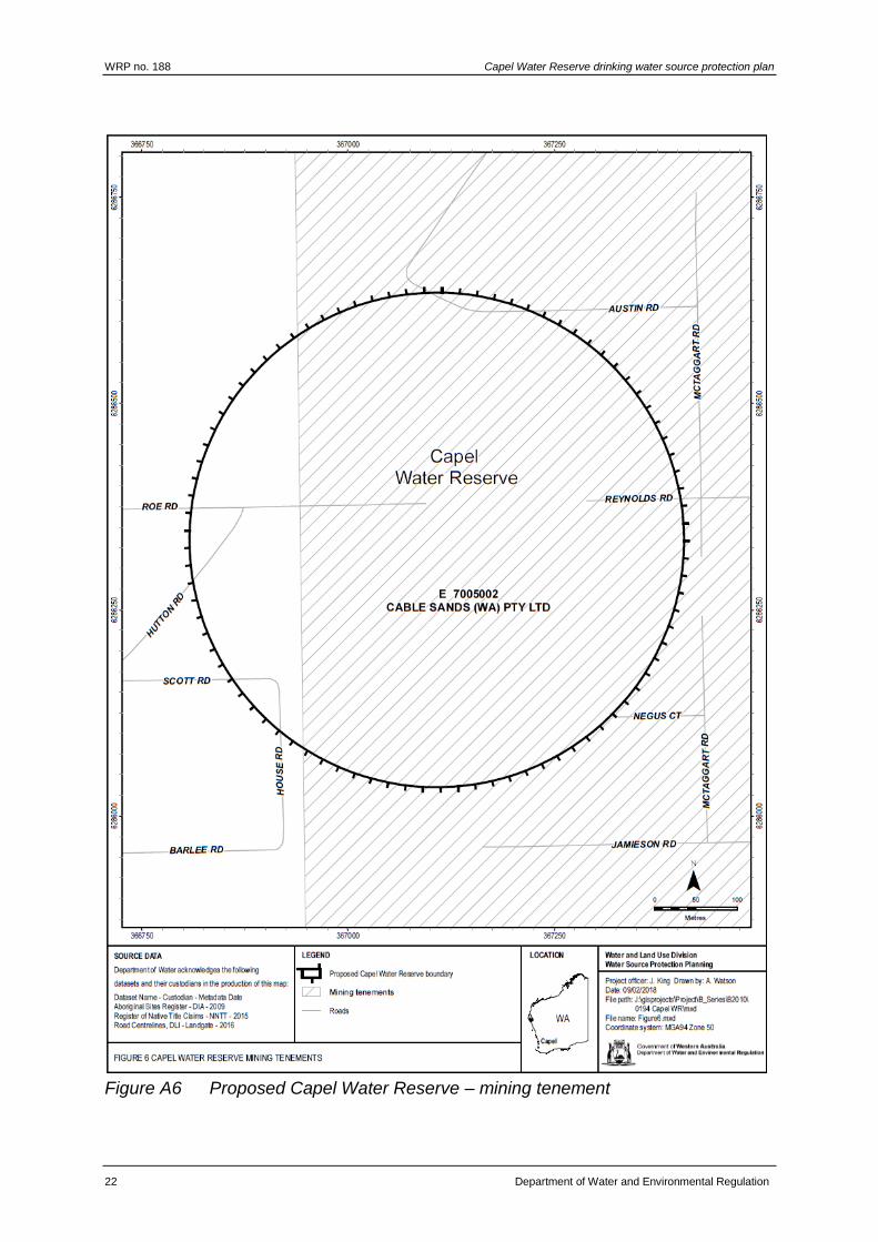
3.3.2 Mining
A single exploration mining tenement covers part of the Capel Water Reserve
(Figure A6). However, mining is unlikely to occur within the water reserve due to the
extent of existing urban land uses.
WRP no. 188 Capel Water Reserve drinking water source protection plan
12 Department of Water and Environmental Regulation
4 Protecting your drinking water source
This plan’s objective is to protect water quality in the proposed Capel Water Reserve
to ensure a safe, reliable source of good quality drinking water to consumers now
and in the future.
4.1 Proclaiming public drinking water source areas
The proclamation process begins with consultation during the development of a
drinking water source protection report. This plan recommends proclamation of the
proposed Capel Water Reserve under the Country Areas Water Supply Act 1947.
Once the water reserve is proclaimed the local government authority will incorporate
the public drinking water source area (PDWSA) into their planning schemes
consistent with State planning policy no. 2.7: Public drinking water source policy.
PDWSAs are commonly shown in planning schemes as special control areas. This
provides guidance for state and local government planning decision makers and
developers.
Proclamation of a PDWSA will not change the zoning of land. All existing, approved
land uses and activities in a proclaimed area can continue. However, we recommend
that best management practices are employed in PDWSAs to protect the quality of
the drinking water source. New developments or expansion of existing land uses or
activities need to consider the recommendations in this plan. As a general guide, the
Department of Water and Environmental Regulation does not recommend land use
intensification in a PDWSA because of the increased risks to drinking water quality
and public health.
For more guidance on appropriate land uses and activities, please refer to our
WQPN no. 25: Land use compatibility in public drinking water source areas
(Department of Water 2016b) which outlines appropriate development and activities
within each of the priority areas (P1, P2 and P3).
4.2 Defining the Capel Water Reserve boundary
We propose a circular boundary for the Capel Water Reserve, based on the extent of
a 300 m wellhead protection zone (WHPZ) around the Capel bore field (Figure A2).
This is considered sufficient protection because:
this protects the area most vulnerable to surface contamination
the Capel production bores are screened very deep (at least 130 m below
ground level) in the Yarragadee aquifer
the semi-confined nature of the aquifer significantly reduces contamination
risks
the production bores are adequately constructed to prevent the ingress of
surface water or groundwater from aquifers above the Yarragadee.

Capel Water Reserve drinking water source protection plan WRP no. 188
Department of Water and Environmental Regulation 13
This boundary has been determined in accordance with our Strategic policy: Protecting public drinking water source areas in Western Australia (Department of Water 2016a).
4.3 Defining priority areas
The protection of PDWSAs relies on statutory and non-statutory measures for water
resource management and land-use planning. The Department of Water and
Environmental Regulation’s policy for the protection of PDWSAs includes a system
that defines three specific priority areas:
Priority 1 (P1) areas have the fundamental water quality objective of risk
avoidance (e.g. state forest and other Crown land).
Priority 2 (P2) areas have the fundamental water quality objective of risk
minimisation (e.g. land that is zoned rural).
Priority 3 (P3) areas have the fundamental water quality objective of risk
management (e.g. areas zoned urban, industrial or commercial).
The determination of priority areas is based on the strategic importance of the land or
water source including risks to water quality and quantity, the local planning-scheme
zoning, the form of land tenure and existing approved land uses or activities. For
further detail, please refer to our WQPN no. 25: Land use compatibility in public
drinking water source areas (Department of Water and Environmental Regulation
2016b).
The proposed priority areas for the Capel Water Reserve have been determined in
accordance with current Department of Water and Environmental Regulation policy.
These areas are described below and displayed in Figure A2. Our WQPN no.25
outlines activities that are ‘acceptable’, ‘compatible with conditions’ or ‘incompatible’
within the different priority areas.
We propose to assign the Water Corporation land, Crown land and government–
owned freehold land in the Capel Water Reserve as P1 because:
water from this source is the only supply available to Capel
current land uses on the Water Corporation and government–owned are
considered ‘acceptable’ in P1.
We propose to assign the remaining private land as P3 because:
current land uses are considered ‘acceptable’ or ‘compatible with conditions’
provided best management practices are applied
the land is privately owned and zoned for urban residential and industrial uses.
4.4 Defining protection zones
In addition to priority areas, protection zones are defined in PDWSAs to protect water
from contamination in the immediate vicinity of water extraction facilities (i.e. bores or
dams). Specific conditions may apply within these zones such as restrictions on the
storage of chemicals or prohibition of public access.

WRP no. 188 Capel Water Reserve drinking water source protection plan
14 Department of Water and Environmental Regulation
WHPZs are generally circular (unless information is available to determine a different
shape or size), with a 500 m radius around each production bore in a P1 area and a
300 m radius around each production bore in P2 and P3 areas. WHPZs do not
extend outside the boundary of the water reserve and they adopt the priority area of
the land over which they occur.
A WHPZ is proposed over the entire Capel Water Reserve (Figure A2) given its small
size.
4.5 Planning for future land uses
As outlined in the WAPC’s State planning policy no. 2.7: Public drinking water source
policy (2003) it is appropriate that the Capel Water Reserve, its priority areas and
protection zone be recognised in the Capel local planning scheme. Any development
proposals in the Capel Water Reserve that are inconsistent with advice in our WQPN
no.25: Land use compatibility in public drinking water source areas (Department of
Water 2016b) or recommendations in this plan, need to be referred to our nearest
regional office for advice.
The department’s protection strategy for PDWSAs provides for approved
developments to continue even if those facilities would not be supported under
current water quality protection criteria. In these instances, the department can
provide advice to landowners or operators on measures they can use to improve
their facilities and reduce water quality contamination risks (see section 4.6: Using
best management practices).
4.6 Using best management practices
There are opportunities to reduce water contamination risks by carefully considering
design and management practices. To help protect water sources, the Department of
Water and Environmental Regulation will continue to encourage the adoption of best
management practices.
Guidelines on best management practices for many land uses are available in the
form of industry codes of practice, environmental guidelines and WQPNs. They
recommend practices to help managers reduce their impacts upon water quality.
These guidelines have been developed in consultation with stakeholders such as
industry groups, agricultural producers, state government agencies and technical
advisers. Examples include WQPN no. 65 Toxic and hazardous substance storage
and use, WQPN no. 70 Wastewater treatment and disposal – domestic systems and
WQPN no. 52 Stormwater management at industrial sites which are listed in this
plan’s Further reading section.
Education and awareness-raising (such as through providing information on signs
and publications) are key mechanisms for protecting water quality, especially for
people visiting the area.

Capel Water Reserve drinking water source protection plan WRP no. 188
Department of Water and Environmental Regulation 15
4.7 Enforcing by-laws and surveying the area
The quality of water in PDWSAs within country areas of the state is protected under
the Country Areas Water Supply Act 1947. Proclamation of PDWSAs allows by-laws
to be applied to protect water quality.
The Department of Water and Environmental Regulation considers by-law
enforcement, through surveillance of land-use activities in PDWSAs, to be an
important mechanism to protect water quality.
Signs will be erected on the boundaries of this water reserve to educate and advise
the public about activities that are prohibited or regulated. This plan recommends that
surveillance and by-law enforcement for the Capel Water Reserve be formally
delegated to the Water Corporation.
4.8 Responding to emergencies
The escape of contaminants during unforeseen incidents and the use of chemicals
during emergency responses can result in water contamination. The Shire of Capel
local emergency management committee (LEMC), through the South West
emergency management district, should be familiar with the location and purpose of
the Capel Water Reserve. A locality plan will be provided to the fire and rescue
services headquarters for the hazardous materials (HAZMAT) emergency advisory
team. The Water Corporation should have an advisory role to the HAZMAT team for
incidents in the Capel Water Reserve.
Personnel who deal with Westplan–HAZMAT (Western Australian plan for hazardous
materials) incidents within the area should have access to a map of the Capel Water
Reserve. These personnel should have an adequate understanding of the potential
impacts of spills on this drinking water source.
4.9 Implementing this plan
Appendix C identifies potential water quality risks associated with existing land uses
in the Capel Water Reserve and recommended protection strategies to deal with
those risks.
Refer to Appendix F to gain a greater understanding about the risk assessment
process we use.

WRP no. 188 Capel Water Reserve drinking water source protection plan
16 Department of Water and Environmental Regulation
5 Recommendations
The following recommendations apply to the entire Capel Water Reserve. The
bracketed stakeholders are those expected to have a responsibility for, or an interest
in, the implementation of that recommendation.
1. Proclaim the Capel Water Reserve under the Country Areas Water Supply Act
1947. (Department of Water and Environmental Regulation)
2. Incorporate the findings of this plan and location of the Capel Water Reserve
(including its priority areas and protection zones) in the Capel local planning
scheme in accordance with the Western Australian Planning Commission’s State
planning policy no. 2.7: Public drinking water source policy. (Shire of Capel)
3. Refer development proposals within the Capel Water Reserve that are
inconsistent with the Department of Water and Environmental Regulation’s
WQPN no.25: Land use compatibility in public drinking water source areas or
recommendations in this plan to the Department of Water and Environmental
Regulation regional office for advice. (Department of Planning, Shire of Capel,
proponents of proposals)
4. Ensure incidents covered by Westplan–HAZMAT in the Capel Water Reserve are
addressed by ensuring that:
the Shire of Capel LEMC is aware of the location and purpose of the Capel
Water Reserve
the locality plan for the Capel Water Reserve is provided to the Fire and
Emergency Services Authority headquarters for the HAZMAT emergency
advisory team
the Water Corporation acts in an advisory role during incidents in the Capel
Water Reserve
personnel dealing with Westplan–HAZMAT incidents in the area have ready
access to a locality map of the Capel Water Reserve and information to help
them recognise the potential impacts of spills on drinking water quality. (Water
Corporation)
5. Erect signs along the boundary of the Capel Water Reserve including an
emergency contact telephone number. (Water Corporation)
6. Connect the residential area to deep sewerage if the area is further subdivided. If
exempt under the Draft government sewerage policy, the use of aerobic treatment
units is recommended. (proponents of proposals)
7. Implement best management practices in the redeveloped special use (industrial)
area to minimise risks to groundwater quality. (landowners)
8. This report will be reviewed in seven years or in response to changes in water
quality contamination risks. (Department of Water and Environmental Regulation)

Capel Water Reserve drinking water source protection plan WRP no. 188
Department of Water and Environmental Regulation 17
Appendices
Appendix A — Figures
Figure A1 Proposed Capel Water Reserve locality map

WRP no. 188 Capel Water Reserve drinking water source protection plan
18 Department of Water and Environmental Regulation
Figure A2 Recommended boundary, priority areas and protection zone for Capel
Water Reserve

Capel Water Reserve drinking water source protection plan WRP no. 188
Department of Water and Environmental Regulation 19
Figure A3 Land use, activities and tenure in the proposed Capel Water Reserve

WRP no. 188 Capel Water Reserve drinking water source protection plan
20 Department of Water and Environmental Regulation
Figure A4 Proposed Capel Water Reserve – aerial and other land use information

Capel Water Reserve drinking water source protection plan WRP no. 188
Department of Water and Environmental Regulation 21
Figure A5 Proposed Capel Water Reserve – Native Title and Aboriginal Sites of
Significance
WRP no. 188 Capel Water Reserve drinking water source protection plan
22 Department of Water and Environmental Regulation
Figure A6 Proposed Capel Water Reserve – mining tenement

Capel Water Reserve drinking water source protection plan WRP no. 188
Department of Water and Environmental Regulation 23
Appendix B — Water quality data
The information provided in this appendix has been supplied by the Water
Corporation.
The Water Corporation has monitored the raw (source) water quality from the Capel
bore field in accordance with the requirements of the Australian drinking water
guidelines (ADWG) (NHMRC & NRMMC 2011) and interpretations agreed to with the
Department of Health. This data shows the quality of water in the public drinking
water source area (PDWSA). The raw water is monitored regularly for:
aesthetic characteristics (non-health-related)
health-related characteristics including:
health-related chemicals
microbiological contaminants.
The following data represents the quality of raw water from Capel bore field. In the
absence of specific guidelines for raw-water quality, the results have been compared
with the ADWG values set for drinking water, which defines the quality requirements
at the customer’s tap. Any water quality parameters that have been detected are
reported; those that on occasion have exceeded the ADWG are in bold and italics to
give an indication of potential raw-water quality issues associated with this source.
The values are taken from ongoing monitoring for the period November 2012 to
October 2017.
It is important to appreciate that the raw-water data presented does not represent the
quality of drinking water distributed to the public. Barriers such as storage and water
treatment exist downstream of the raw water to ensure it meets the requirements of
the ADWG.
For more information on the quality of drinking water supplied to the Capel scheme
refer to the most recent Water Corporation drinking water quality annual report at
watercorporation.com.au.
Aesthetic characteristics
The aesthetic quality analyses for raw water from Capel bore field are summarised in
the following table.

WRP no. 188 Capel Water Reserve drinking water source protection plan
24 Department of Water and Environmental Regulation
Table 2 Aesthetic detections for Capel bore field
Parameter Units ADWG
aesthetic
guideline
value*
Capel bore field
Range Median
Aluminium (unfiltered) mg/L 0.2 <0.008–0.01 <0.008
Chloride mg/L 250 50–60 53.2
Colour (true) TCU 15 <1–2 <1
Conductivity mS/m – 37–40 38.2
Hardness as CaCO3 mg/L 200 44–50 46.9
Iron unfiltered mg/L 0.3 0.06–7.4 4.6
Manganese unfiltered mg/L 0.1 <0.002–0.16 <0.002
pH measured in
laboratory
no units 6.5–8.5 6.41–6.81 6.6
Silica mg/L 80 14-16 14.4
Sodium mg/L 180 44–49 46.4
Sulfate mg/L 250 16–19 17.5
Total filterable solids by
summation
mg/L 600 258–289 271.7
Turbidity NTU 5 <0.1–50 <0.1
* An aesthetic guideline value is the concentration or measure of a water quality
characteristic that is associated with good quality water
Health-related chemicals
Raw water from Capel bore field is analysed for chemicals that are harmful to human
health, including inorganics, heavy metals, industrial hydrocarbons and pesticides.
Health-related parameters that have been detected in the source are summarised in
the following table.
Capel Water Reserve drinking water source protection plan WRP no. 188
Department of Water and Environmental Regulation 25
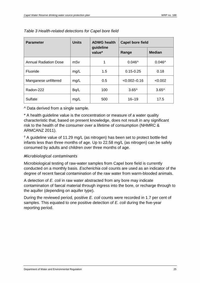
Table 3 Health-related detections for Capel bore field
Parameter Units ADWG health
guideline
value*
Capel bore field
Range Median
Annual Radiation Dose mSv 1 0.046^ 0.046^
Fluoride mg/L 1.5 0.15-0.25 0.18
Manganese unfiltered mg/L 0.5 <0.002–0.16 <0.002
Radon-222 Bq/L 100 3.65^ 3.65^
Sulfate mg/L 500 16–19 17.5
^ Data derived from a single sample.
* A health guideline value is the concentration or measure of a water quality
characteristic that, based on present knowledge, does not result in any significant
risk to the health of the consumer over a lifetime of consumption (NHMRC &
ARMCANZ 2011).
† A guideline value of 11.29 mg/L (as nitrogen) has been set to protect bottle-fed
infants less than three months of age. Up to 22.58 mg/L (as nitrogen) can be safely
consumed by adults and children over three months of age.
Microbiological contaminants
Microbiological testing of raw-water samples from Capel bore field is currently
conducted on a monthly basis. Escherichia coli counts are used as an indicator of the
degree of recent faecal contamination of the raw water from warm-blooded animals.
A detection of E. coli in raw water abstracted from any bore may indicate
contamination of faecal material through ingress into the bore, or recharge through to
the aquifer (depending on aquifer type).
During the reviewed period, positive E. coli counts were recorded in 1.7 per cent of
samples. This equated to one positive detection of E. coli during the five-year
reporting period.
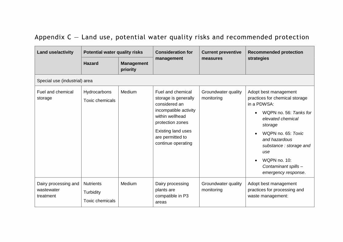
Appendix C — Land use, potential water quality risks and recommended protection
Land use/activity Potential water quality risks Consideration for
management
Current preventive
measures
Recommended protection
strategies Hazard Management
priority
Special use (industrial) area
Fuel and chemical
storage
Hydrocarbons
Toxic chemicals
Medium Fuel and chemical
storage is generally
considered an
incompatible activity
within wellhead
protection zones
Existing land uses
are permitted to
continue operating
Groundwater quality
monitoring
Adopt best management
practices for chemical storage
in a PDWSA:
WQPN no. 56: Tanks for
elevated chemical
storage
WQPN no. 65: Toxic
and hazardous
substance : storage and
use
WQPN no. 10:
Contaminant spills –
emergency response.
Dairy processing and
wastewater
treatment
Nutrients
Turbidity
Toxic chemicals
Medium Dairy processing
plants are
compatible in P3
areas
Groundwater quality
monitoring
Adopt best management
practices for processing and
waste management:

Land use/activity Potential water quality risks Consideration for
management
Current preventive
measures
Recommended protection
strategies Hazard Management
priority
WQPN no. 12: Dairy
processing plants
WQPN 22: Irrigation with
nutrient-rich wastewater
WQPN 39: Ponds for
stabilising organic
matter
Connection to deep sewerage
when feasible
Car parks
Vehicle use and
maintenance
Hydrocarbons
Turbidity
Medium Current low levels of
vehicle use
Groundwater quality
monitoring
Adopt best management
practices to manage
contaminated stormwater:
WQPN 29: Mobile
mechanical servicing
and cleaning
WQPN 68: Mechanical
equipment wash down
WQPN 52: Stormwater
management at
industrial sites

Land use/activity Potential water quality risks Consideration for
management
Current preventive
measures
Recommended protection
strategies Hazard Management
priority
Demolition and
redevelopment
works
Hydrocarbons
Toxic chemicals
Turbidity
Medium Works have the
potential to increase
turbidity or
contaminate
stormwater by
mobilising legacy
hazardous and toxic
substances
Groundwater quality
monitoring
Adopt best management
practices during works:
WQPN 52: Stormwater
management at
industrial sites
WQPN 10: Contaminant
spills - emergency
response
Septic tanks Pathogens –
human
Nutrients
Medium Depth of abstraction
is greater than
130 m
Groundwater quality
monitoring
Adopt best management
practices and increase
awareness of the Capel Water
Reserve:
Living and working in
public drinking water
source areas brochure
WQPN no. 70:
Wastewater treatment
and disposal – domestic
systems

Land use/activity Potential water quality risks Consideration for
management
Current preventive
measures
Recommended protection
strategies Hazard Management
priority
Connection to deep sewerage
or replacement with ATUs when
the site is redeveloped
Water Corporation compound
Water Corporation
compound
Pathogens –
small animals
and insects
Medium A pathogen
detection in raw
water was attributed
to ingress of small
animals or insects
into the production
bores
Production bores are
now permanently
sealed and capped
to prevent ingress of
small animals and
insects
Groundwater quality
monitoring
Water Corporation site
inspections and surveillance
Residential area
Septic tanks Pathogens –
human
Nutrients
Medium There are relatively
few houses within
the water reserve
Depth of abstraction
is greater than
130 m
Groundwater quality
monitoring
Adopt best management
practices and increase
awareness of the Capel Water
Reserve:
Land use/activity Potential water quality risks Consideration for
management
Current preventive
measures
Recommended protection
strategies Hazard Management
priority
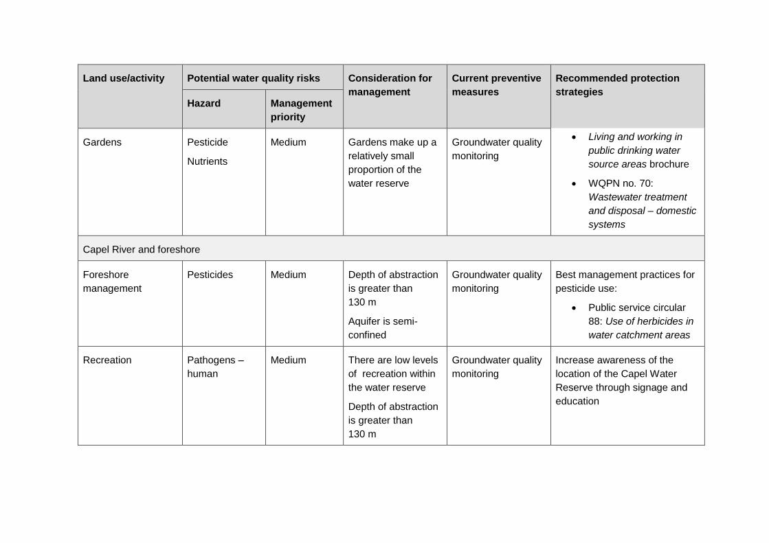
Gardens Pesticide
Nutrients
Medium Gardens make up a
relatively small
proportion of the
water reserve
Groundwater quality
monitoring
Living and working in
public drinking water
source areas brochure
WQPN no. 70:
Wastewater treatment
and disposal – domestic
systems
Capel River and foreshore
Foreshore
management
Pesticides Medium Depth of abstraction
is greater than
130 m
Aquifer is semi-
confined
Groundwater quality
monitoring
Best management practices for
pesticide use:
Public service circular
88: Use of herbicides in
water catchment areas
Recreation Pathogens –
human
Medium There are low levels
of recreation within
the water reserve
Depth of abstraction
is greater than
130 m
Groundwater quality
monitoring
Increase awareness of the
location of the Capel Water
Reserve through signage and
education
Land use/activity Potential water quality risks Consideration for
management
Current preventive
measures
Recommended protection
strategies Hazard Management
priority
Stock and cropping Pathogens –
domestic
animals
Pesticides
Nutrients
Pesticides
Medium Depth of abstraction
is greater than
130 m
Groundwater quality
monitoring
Adopt best management
practices and increase
awareness of the Capel Water
Reserve:
Living and working in
public drinking water
source areas brochure
WQPN no. 1:
Agriculture: dryland
crops near sensitive
water resources
Roads and vehicles
Vehicle use, storage
and hydrocarbon
spills
Hydrocarbons
Heavy metals
Turbidity
Medium Relatively small
number of vehicles
in residential area
Local traffic only
within the water
reserve
Groundwater quality
monitoring
Increase awareness of the
Capel Water Reserve:
Living and working in
public drinking water
source areas brochure
Ensure groundwater quality
issues are considered during
incidents within the Capel Water

Land use/activity Potential water quality risks Consideration for
management
Current preventive
measures
Recommended protection
strategies Hazard Management
priority
Reserve covered by Westplan–
HAZMAT
Catchment surveillance

Capel Water Reserve drinking water source protection plan WRP no. 188
Department of Water and Environmental Regulation 33
Appendix D — Photographs
Photographs by J. King
Figure D1 Production bore 1/72 – permanently offline
Figure D2 Production bore 1/71

WRP no. 188 Capel Water Reserve drinking water source protection plan
34 Department of Water and Environmental Regulation
Figure D3 Production bore 2/16
Figure D4 Production bore 1/16

Capel Water Reserve drinking water source protection plan WRP no. 188
Department of Water and Environmental Regulation 35
Figure D5 Self-bunded diesel generator
Figure D6 Fenced compound and signs
WRP no. 188 Capel Water Reserve drinking water source protection plan
36 Department of Water and Environmental Regulation
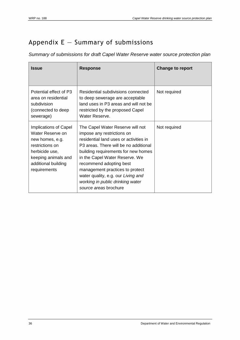
Appendix E — Summary of submissions
Summary of submissions for draft Capel Water Reserve water source protection plan
Issue Response Change to report
Potential effect of P3
area on residential
subdivision
(connected to deep
sewerage)
Residential subdivisions connected
to deep sewerage are acceptable
land uses in P3 areas and will not be
restricted by the proposed Capel
Water Reserve.
Not required
Implications of Capel
Water Reserve on
new homes, e.g.
restrictions on
herbicide use,
keeping animals and
additional building
requirements
The Capel Water Reserve will not
impose any restrictions on
residential land uses or activities in
P3 areas. There will be no additional
building requirements for new homes
in the Capel Water Reserve. We
recommend adopting best
management practices to protect
water quality, e.g. our Living and
working in public drinking water
source areas brochure
Not required

Capel Water Reserve drinking water source protection plan WRP no. 188
Department of Water and Environmental Regulation 37
Appendix F — How do we protect public drinking water source areas?
The Australian drinking water guidelines (ADWG; NHMRC & NRMMC 2011) outline
how we should protect drinking water in Australia. The ADWG recommends a
‘catchment to consumer’ framework that uses an approach based on preventive risk
and multiple barriers. A similar approach is recommended by the World Health
Organization.
The catchment to consumer framework applies across the entire drinking water
supply system – from the water source to the taps in your home. It ensures a holistic
assessment of water quality risks and solutions to ensure the delivery of a reliable
and safe drinking water to supply your home.
An approach based on preventive risk means that we look at all the different risks to
water quality. We determine what risks can reasonably be avoided and what risks
need to be minimised or managed to protect public health. This approach means that
the inherent risks to water quality are as low as possible. A risk-based approach is
often suggested as a way to address risks to water quality in a public drinking water
source area (PDWSA; the area from which water is captured to supply drinking
water). However, a risk-based approach is not the same as an approach based on
preventive risk. A risk-based approach is inadequate for addressing risks to public
health, and is not recommended by the ADWG.
A multiple-barrier approach means that we use different barriers against
contamination at different stages of a drinking water supply system. The first and
most important barrier is protecting PDWSA. If we get this barrier right, it has a flow-
on effect that can result in a lower cost, safer drinking water supply. Other barriers
against contamination include storage of water to help reduce contaminant levels,
disinfecting the water (for example chlorination to inactivate pathogens),
maintenance of pipes and testing of water quality.
Research and experience shows that a combination of catchment protection and
water treatment is safer than relying on either barrier on its own. That’s why this
drinking water source protection report is important. We should not forget that
ultimately it’s about safeguarding your health by protecting water quality now and for
the future.
An additional benefit from PDWSA protection is that it complements the state’s
conservation initiatives.
In Western Australia, the Department of Water and Environmental Regulation
protects PDWSAs by implementing the ADWG, writing reports, policies and
guidelines, and providing input into land use planning.
This drinking water protection report achieves elements 2 and 3 of the 12 elements in
the ADWG recommended for protecting drinking water. It shows the PDWSA’s
location, its characteristics, existing and potential water quality contamination risks,
and makes recommendations to deal with those risks.
WRP no. 188 Capel Water Reserve drinking water source protection plan
38 Department of Water and Environmental Regulation
The Metropolitan Water Supply, Sewerage, and Drainage Act 1909 and the Country
Areas Water Supply Act 1947 provide us with legislative tools to protect water quality
for PDWSAs. These Acts and the associated by-laws allow us to assess and manage
the water quality contamination risks from different land uses and activities. The
department works cooperatively with other agencies and the community to implement
this legislation and develop drinking water source protection reports. For example,
the Western Australian Planning Commission has developed a number of state
planning policies to help guide development in PDWSAs.
An important step in maximising the protection of water quality in PDWSAs is to
define their boundaries, priority areas and protection zones to help guide land use
planning and to identify where legislation applies. Our Strategic policy: Protecting
public drinking water source areas in Western Australia (Department of Water 2016a)
describes how we do this. It is available www.dwer.wa.gov.au.
There are three different priority areas. The objective of priority 1 (P1) areas is risk
avoidance – ensuring there is no degradation of the water quality (for example over
Crown land). The objective of priority 2 (P2) areas is risk minimisation – maintaining
or improving water quality (for example over rural-zoned land). The objective of
priority 3 (P3) areas is risk management – maintaining the water quality for as long
as possible (for example, urban- or commercial-zoned land). Protection zones
surround drinking water abstraction bores and surface water reservoirs so that the
most vulnerable areas are protected from contamination.
Our Water quality protection note (WQPN) no. 25: Land use compatibility tables for
public drinking water source areas (Department of Water 2016b) outlines appropriate
development and activities within each of the priority areas (P1, P2 and P3).
With more than 120 constituted PDWSAs across Western Australia, the department
prioritises the update of drinking water source protection reports (such as this
document). Our aim is to update each report every seven years. In some locations,
more frequent updates may be required to address changing water quality risks and
land uses. These updates allow us to make changes to the PDWSA boundary,
priority areas and protection zones if required. They also allow solutions to new water
quality risks to be considered.
There are three different types of drinking water source protection report – each
providing for different needs. The following table shows the differences between the
types of reports.
There is a fourth type of report – Land use and water management strategy – that
performs the same functions as a drinking water source protection report. However,
these strategies are prepared by the Western Australian Planning Commission (with
input from the Department of Water and Environmental Regulation) and are strategic
documents that integrate land use planning with water management. There are
currently land use and water management strategies for Gnangara, Jandakot and
Middle Helena.

Capel Water Reserve drinking water source protection plan WRP no. 188
Department of Water and Environmental Regulation 39
If you would like more information about the ADWG and how we protect drinking
water in Western Australia, visit www.dwer.wa.gov.au > what we do > water >urban
water > drinking water, or read our Strategic policy: Protecting public drinking water
source areas in Western Australia (Department of Water 2016a). You can also
contact the Department of Water and Environmental Regulation’s Water source
protection planning branch on +61 8 6364 7600 or email
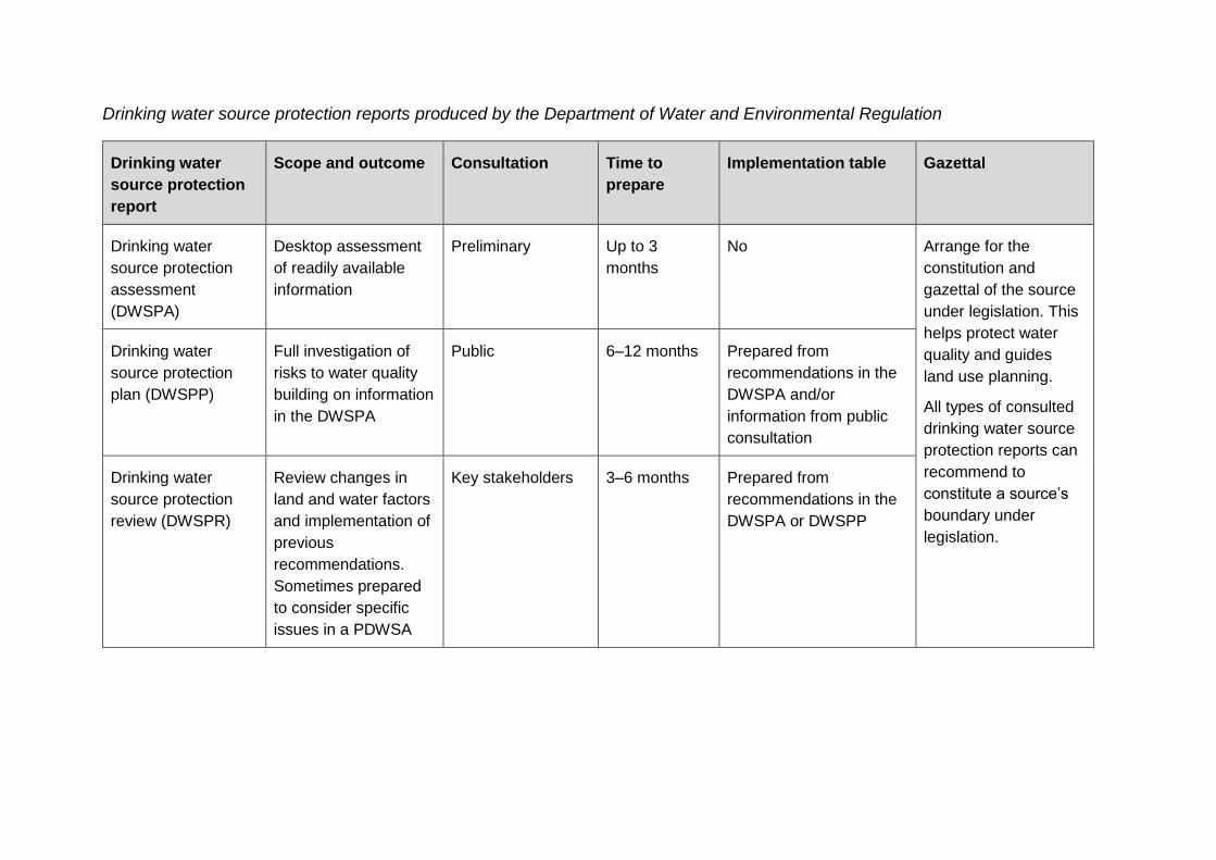
Drinking water source protection reports produced by the Department of Water and Environmental Regulation
Drinking water
source protection
report
Scope and outcome Consultation Time to
prepare
Implementation table Gazettal
Drinking water
source protection
assessment
(DWSPA)
Desktop assessment
of readily available
information
Preliminary Up to 3
months
No Arrange for the
constitution and
gazettal of the source
under legislation. This
helps protect water
quality and guides
land use planning.
All types of consulted
drinking water source
protection reports can
recommend to
constitute a source’s
boundary under
legislation.
Drinking water
source protection
plan (DWSPP)
Full investigation of
risks to water quality
building on information
in the DWSPA
Public 6–12 months Prepared from
recommendations in the
DWSPA and/or
information from public
consultation
Drinking water
source protection
review (DWSPR)
Review changes in
land and water factors
and implementation of
previous
recommendations.
Sometimes prepared
to consider specific
issues in a PDWSA
Key stakeholders 3–6 months Prepared from
recommendations in the
DWSPA or DWSPP

Capel Water Reserve drinking water source protection plan WRP no. 188
Department of Water and Environmental Regulation 41
Appendix G — Understanding risks to drinking water quality
The existing integrated land use planning and public drinking water source area
(PDWSA) protection program is based on the findings of three parliamentary
committee reports in 1994, 2000 and 2010 (see Further reading). Since 1995, this
program has resulted in the development of four Western Australian Planning
Commission state planning policies (SPPs), recognising the importance of PDWSAs
for the protection of water quality and public health:
SPP no. 2.2: Gnangara groundwater protection
SPP no. 2.3: Jandakot groundwater protection
SPP no. 2.7: Public drinking water source policy
SPP no. 2.9: Water resources.
This integrated program relies upon a risk assessment process based on preventive
risk in each PDWSA through the development of drinking water source protection
reports. It is important to understand how risks are assessed to appreciate the impact
of development within PDWSAs.
Risk-based assessments normally focus on the acceptability of risks after mitigation
(residual risks). For drinking water sources, an assessment based on preventive risk
that considers both the maximum and residual risks is required. This means that in
some cases, the maximum risks from land uses will still be considered unacceptable,
even after mitigation has reduced the risk. This is a more conservative approach
needed to protect the health of consumers.
Water quality risks are evaluated by considering the type and scale of a potential
contamination event (consequence), together with the probability/frequency of that
event occurring (likelihood). An understanding of this relationship will prevent the
common misunderstanding that probability equals risk (see risk matrix below).

WRP no. 188 Capel Water Reserve drinking water source protection plan
42 Department of Water and Environmental Regulation
Risk matrix: Level of risk (from the Australian drinking water guidelines 2011)
Likelihood Consequences
Insignificant Minor Moderate Major Catastrophi
c
Almost
certain
Moderate High Very high Very high Very high
Likely Moderate High High Very high Very high
Possible Low Moderate High Very high Very high
Unlikely Low Low Moderate High Very high
Rare Low Low Moderate High High
For example, just because a drinking water contamination incident has not occurred
for many years (low likelihood) does not mean that the risk is low. This is because we
also need to consider the consequence of that contamination when determining risk.
Furthermore, no previous detection of contamination is not proof that the risk is
acceptable.

Capel Water Reserve drinking water source protection plan WRP no. 188
Department of Water and Environmental Regulation 43
List of shortened forms
ABS Australian Bureau of Statistics
ADWG Australian drinking water guidelines
AEP Annual exceedance probability
ANZECC Australian and New Zealand Environment Conservation Council
ARMCANZ Agriculture and Resource Management Council of Australia and
New Zealand
ATU aerobic treatment unit
HAZMAT hazardous materials
kL kilolitre
km kilometre
LEMC local emergency management committee
m metres
mg/L milligram per litre
mL millilitre
mm millimetre
mSv millisievert
mS/m millisiemens per metre
NHMRC National Health and Medical Research Council
NRMMC Natural Resource Management Ministerial Council
NTU nephelometric turbidity units
PSC 88 Public sector circular number 88
PDWSA public drinking water source area
TCU true colour units
TDS total dissolved solids
WAPC Western Australian Planning Commission
Westplan–
HAZMAT
Western Australian plan for hazardous materials

WRP no. 188 Capel Water Reserve drinking water source protection plan
44 Department of Water and Environmental Regulation
WHPZ wellhead protection zone
WQPN water quality protection note
Capel Water Reserve drinking water source protection plan WRP no. 188
Department of Water and Environmental Regulation 45
Glossary
Abstraction The pumping of groundwater from an aquifer, or the removal of
water from a waterway or water body.
Adsorb Adsorb means to accumulate on the surface of something.
Aesthetic
guideline value
The concentration or measure of a water quality characteristic that
is associated with acceptability of water to the consumer, e.g.
appearance, taste and odour (NHMRC & NRMMC 2011).
Allocation The quantity of water that a licensee is permitted to abstract is
their allocation, usually specified in kilolitres per annum (kL/a).
Aquifer An aquifer is a geological formation or group or formations able to
receive, store and transmit significant quantities of water.
Australian
drinking water
guidelines
The National water quality management strategy: Australian
drinking water guidelines 6, 2011 (NHMRC & NRMMC 2011)
(ADWG) outlines acceptable criteria for the quality of drinking
water in Australia (see this plan’s Bibliography).
Bore A bore is a narrow, lined hold drilled into the ground to monitor or
draw groundwater (also called a well).
Bore field A group of bores to monitor or withdraw groundwater is referred to
as a bore field (also see wellfield).
Catchment The physical area of land which intercepts rainfall and contributes
the collected water to surface water (streams, rivers, wetlands) or
groundwater.
Confined
aquifer
An aquifer that is confined between non-porous rock formations
(such as shale and siltstone) and therefore contains water under
pressure.
Drinking water
source
protection
report
This is a report on water quality hazards and risk levels within a
public drinking water source area that includes recommendations
to avoid, minimise, or manage those risks for the protection of the
water supply in the provision of safe drinking water supply.
Effluent Effluent is treated or untreated liquid, solid or gaseous waste
discharged by a process such as through a septic tank and leach
drain system.
Electrical
conductivity
This estimates the volume of TDS or the total volume of dissolved
ions in a solution (water) corrected to 25ºC. Measurement units
include millisiemens per metre and microsiemens per centimetre.

WRP no. 188 Capel Water Reserve drinking water source protection plan
46 Department of Water and Environmental Regulation
Gigalitre A gigalitre is equivalent to 1 000 000 000 litres or one million
kilolitres.
Half-life The time required for one half of a sample of material to
disintegrate.
Health
guideline value
The concentration or measure of a water quality characteristic
that, based on current knowledge, does not result in any
significant risk to the health of the consumer over a lifetime of
consumption (NHMRC & NRMMC 2011).
Hydrocarbons A class of compounds containing only hydrogen and carbon, such
as methane, ethylene, acetylene and benzene. Fossil fuels such
as oil, petroleum and natural gas all contain hydrocarbons.
Hydrogeology The study of groundwater, especially relating to the distribution of
aquifers, groundwater flow and groundwater quality.
Leaching/
leachate
The process by which materials such as organic matter and
mineral salts are washed out of a layer of soil or dumped material
by being dissolved or suspended in percolating rainwater. The
material washed out is known as leachate. Leachate can pollute
groundwater and waterways.
mg/L A milligram per litre (0.001 grams per litre) is a measurement of a
total dissolved solid in a solution.
Millisievert A millisievert is a measure of annual radiological dose, with a
natural dose equivalent to 2 mSv/yr.
Millisiemens
per metre
Millisiemens per metre is a measure of electrical conductivity of a
solution or soil and water mix that provides a measurement of
salinity.
Nephelometric
turbidity units
Nephelometric turbidity units are a measure of turbidity in water.
Nutrients Minerals, particularly inorganic compounds of nitrogen (nitrate and
ammonia) and phosphorous (phosphate) dissolved in water which
provide nutrition (food) for plant growth.
Pathogen A disease-producing organism that can cause sickness and
sometimes death through the consumption of water, including
bacteria (such as Escherichia coli), protozoa (such as
Cryptosporidium and Giardia) and viruses.
Pesticides Collective name for a variety of insecticides, fungicides,
herbicides, algicides, fumigants and rodenticides used to kill
organisms.
Capel Water Reserve drinking water source protection plan WRP no. 188
Department of Water and Environmental Regulation 47
pH A logarithmic scale for expressing the acidity or alkalinity of a
solution. A pH below seven indicates an acidic solution and above
seven indicates an alkaline solution.
Porosity The state of quality of a material to be porous – that is permeable
by water.
Public drinking
water source
area
The area from which water is captured to supply drinking water. It
includes all underground water pollution control areas, catchment
areas and water reserves constituted under the Metropolitan
Water Supply, Sewerage, and Drainage Act 1909 and the Country
Areas Water Supply Act 1947.
Public sector
circular number
88
A state government circular produced by the Department of Health
providing guidance on appropriate herbicide use within water
catchment areas.
Recharge Recharge is the action of water infiltrating through the soil/ground
to replenish an aquifer.
Recharge area An area through which water from a groundwater catchment
percolates to replenish (recharge) an aquifer. An unconfined
aquifer is recharged by rainfall throughout its distribution. Confined
aquifers are recharged in specific areas where water leaks from
overlying aquifers, or where the aquifer rises to meet the surface.
Scheme supply Water diverted from a source or sources by a water authority or
private company and supplied via a distribution network to
customers for urban and industrial use or for irrigation.
Semi-confined
aquifer
A semi-confined aquifer or leaky aquifer is saturated and bounded
above by a semi-permeable layer and below by a layer that is
either impermeable or semi-permeable.
Stormwater Rainwater that has run off the ground surface, roads, paved areas
etc., and is usually carried away by drains.
Total dissolved
solids
Total dissolved solids consist of inorganic salts and small amounts
of organic matter that are dissolved in water. Clay particles,
colloidal iron and manganese oxides, and silica fine enough to
pass through a 0.45 micrometer filter membrane can also
contribute to total dissolved solids. Total dissolved solids comprise
sodium, potassium, calcium, magnesium, chloride, sulfate,
bicarbonate, carbonate, silica, organic matter, fluoride, iron,
manganese, nitrate (and nitrite) and phosphate (NHMRC &
NRMMC 2011).
WRP no. 188 Capel Water Reserve drinking water source protection plan
48 Department of Water and Environmental Regulation
Total filterable
solids by
summation
Total filterable solids by summation is a water quality test which is
a total of the following ions: Na (sodium), K (potassium), Ca
(calcium), Mg (magnesium), Cl equivalent (chloride), alkalinity
equivalent, SO4 equivalent (sulfate) or S (sulfur) in grams, Fe
(iron), Mn (manganese), and SiO2 (silicon oxide). It is used as a
more accurate measure than total dissolved solids (TDS). The
higher the value, the more solids that are present and generally
the saltier the taste.
Treatment Application of techniques such as settlement, filtration and
chlorination to render water suitable for specific purposes,
including drinking and discharge to the environment.
True colour
units
True colour units are a measure of degree of colour in water.
Turbidity The cloudiness or haziness of water caused by the presence of
fine suspended matter.
Unconfined
aquifer
An aquifer in which the upper surface of water is lower than the
top of the aquifer itself. The upper surface of the groundwater
within the aquifer is called the watertable. This is also known as a
superficial aquifer.
Wastewater Water that has been used for some purpose and would normally
be treated and discarded. Wastewater usually contains significant
quantities of pollutant.
Water quality Water quality is the collective term for the physical, aesthetic,
chemical and biological properties of water.
Water reserve A water reserve is an area proclaimed under the Country Areas
Water Supply Act 1947 or the Metropolitan Water Supply,
Sewerage, and Drainage Act 1909 for the purposes of protecting a
drinking water supply.
Watertable The upper saturated level of the unconfined groundwater is
referred to as the watertable.
Wellfield A wellfield is a group of bores located in the same area used to
monitor or withdraw groundwater.
Wellhead The top of a well (or bore) used to draw groundwater is referred to
as a wellhead.
Wellhead
protection zone
A wellhead protection zone is usually declared around wellheads
in public drinking water source areas to protect the groundwater
from immediate contamination threats in the nearby area.
Capel Water Reserve drinking water source protection plan WRP no. 188
Department of Water and Environmental Regulation 49
Western
Australian
hazardous
materials
emergency
management
scheme
This is now known as Westplan–HAZMAT.

WRP no. 188 Capel Water Reserve drinking water source protection plan
50 Department of Water and Environmental Regulation
References
Australian Bureau of Statistics 2016, 2016 Census QuickStats – Capel (state
suburb), Australian Bureau of Statistics, Canberra, available
www.censusdata.abs.gov.au.
Bureau of Meteorology 2018, Monthly rainfall Capel North,
www.bom.gov.au/climate/data, Australian Government, accessed 12 April 2018.
Department of Planning 2016, Draft Government Sewerage Policy, Department of
Planning, Perth, available www.planning.wa.gov.au.
Department of Water 2009, South West groundwater area water allocation plan
Water resource allocation and planning series, Report no. 21, Department of
Water and Environmental Regulation, Perth, available www.dwer.wa.gov.au.
—— Water quality protection notes (WQPNs) Department of Water and
Environmental Regulation, Perth, available www.dwer.wa.gov.au.
2009, WQPN 36: Protecting public drinking water source areas
2016b, WQPN 25: Land use compatibility tables for public drinking water
source areas
——2012, Statewide Policy no.13: Recreation within public drinking water source
areas on Crown land.
——2016a, Strategic policy: Protecting public drinking water source areas in Western
Australia, Government of Western Australia, Perth, available
www.dwer.wa.gov.au.
Government of Western Australia 1914, Rights in Water and Irrigation Act, Reprinted
under the Reprints Act 1984 as at 1 February 2008, State Law Publisher, Perth.
——1909, Metropolitan Water Supply, Sewerage, and Drainage Act, reprinted under
the Reprints Act 1984 as at 27 April 2008, State Law Publisher, Perth.
——1947, Country Areas Water Supply Act, reprinted under the Reprints Act 1984 as
at 4 May 2012, State Law Publisher, Perth.
——1972, Aboriginal Heritage Act, reprinted under the Reprints Act 1984 as at 18
September 2010, State Law Publisher, Perth.
——2003, Contaminated Sites Act, State Law Publisher, Perth.
——2007, State water plan 2007, Department of the Premier and Cabinet, Perth.
Geldreich, EE 1996, ‘Pathogenic agents in freshwater resources’, Hydrological
Processes, vol. 10, pp. 315-333.
National Health and Medical Research Council (NHMRC) & Natural Resource
Management Ministerial Council (NRMMC) 2011, National Water Quality
Management Strategy: Australian drinking water guidelines, Australian
Government, Canberra.
Capel Water Reserve drinking water source protection plan WRP no. 188
Department of Water and Environmental Regulation 51
——2004, Water made clear – A consumer guide to accompany the Australian
drinking water guidelines 2004, Australian Government, Canberra.
National Uniform Drillers Licensing Committee 2012, Minimum construction
requirements for water bores in Australia, 3rd edn, Australian Government
National Water Commission, Victoria, available wwww.dwer.wa.gov.au.
Robertson, JB & Edbery, SC 1997, Natural protection of spring and well drinking
water against surface microbial contamination. I. Hydrogeological parameters,
Critical Reviews in Microbiology, vol. 23(2), pp. 143 – 178.
Shire of Capel 2017, District profile, Shire of Capel, available www.capel.wa.gov.au.
Water and Rivers Commission 1999, Capel River Action Plan, Water and Rivers
Commission, Perth, available www.dwer.wa.gov.au.
Water Corporation 2006, SG097 Source protection operations manual, Water
Corporation, Perth.
Western Australian Planning Commission 1997, State planning strategy, Government
of Western Australia, Perth.
——2003, State planning policy no. 2.7: Public drinking water source policy,
Government Gazette Western Australia, 10 June 2003, pp. 2077-82,
Government of Western Australia, Perth.
——2006, State planning policy no. 2.9: Water resources, Government Gazette
Western Australia, 19 December 2006, pp. 5707-22 Government of Western
Australia, Perth.

WRP no. 188 Capel Water Reserve drinking water source protection plan
52 Department of Water and Environmental Regulation
Further reading
Agriculture and Resource Management Council of Australia and New Zealand
(ARMCANZ) & Australian and New Zealand Environment and Conservation
Council (ANZECC) 1996, Draft rural land uses and water quality – A community
resource document, ARMCANZ & ANZECC, Canberra.
Department of Health 2007, Use of herbicides in water catchment areas, Circular no:
PSC 88, February 2007, Department of Health, Perth.
Department of Water & Department of Health 2008, Risks from pathogenic micro-
organisms in public drinking water source areas, Department of Water and
Environmental Regulation, Perth.
Department of Water 2006, Capel River – surface water management. Issue scoping
report, Department of Water and Environmental Regulation, Perth, available
www.dwer.wa.gov.au.
——2011, Living and working in public drinking water source areas, Department of
Water and Environmental Regulation, Perth, available www.dwer.wa.gov.au.
——Water quality protection notes (WQPNs) Department of Water and
Environmental Regulation, Perth, available wwww.dwer.wa.gov.au.
2006, WQPN 10: Contaminant spills – emergency response
2006, WQPN 13: Dewatering of soils at construction sites
2006 WQPN 56: Tanks for elevated chemical storage
2008 WQPN 22: Irrigation with nutrient rich wastewater
2009 WQPN 39: Ponds for stabilising organic matter
2010 WQPN 52: Stormwater management at industrial sites
2012 WQPN 12: Dairy processing plants
2013 WQPN 29: Mobile mechanical servicing and cleaning
2013 WQPN 68: Mechanical equipment wash down
2015 WQPN 65: Toxic and hazardous substances
2016 WQPN 70: Wastewater treatment and disposal – domestic systems
Hrudey, SE & Hrudey, EJ 2004, Safe drinking water – Lessons from recent outbreaks
in affluent nations, IWA Publishing, London.
National Health and Medical Research Council (NHMRC) & Natural Resource
Management Ministerial Council (NRMMC) 2004, Water made clear – A
consumer guide to accompany the Australian drinking water guidelines 2004,
Australian Government, Canberra.
Western Australian Planning Commission 2006, State planning policy no. 2.9: Water
resources, Government Gazette Western Australia, 19 December 2006, pp.
5707-22 Government of Western Australia, Perth.

Capel Water Reserve drinking water source protection plan WRP no. 188
Department of Water and Environmental Regulation 53
World Health Organization 2004, Guidelines for drinking-water quality – Volume 1 –
Recommendations, 3rd edn, World Health Organization, Geneva.

Department of Water and Environmental Regulation Prime House
8 Davidson Terrace Joondalup Western Australia 6027
Locked Bag 10, Joondalup DC WA 6919
Phone: 08 6364 7000Fax: 08 6364 7001
National Relay Service 13 36 77 dwer.wa.gov.au
10741 0519