Canadian Geographic Challenge 2017 Mock Challenge...
14
Level 2 Classroom Page 1 Canadian Geographic Challenge 2017 Mock Challenge Level 2 Classroom Name Date Class Scores Round 1: Canadian Symbols /10 Round 2: Topography /5 Round 3: Photographs /5 Round 4: Water /10 Round 5: Populations /5 Round 6: Cartograms /5 Round 7: Miscellaneous Trivia /10 TOTAL SCORE /50
Transcript of Canadian Geographic Challenge 2017 Mock Challenge...

Level 2 Classroom Page 1
Canadian Geographic Challenge
2017 Mock Challenge
Level 2 Classroom Name
Date
Class
Scores
Round 1: Canadian Symbols /10
Round 2: Topography /5
Round 3: Photographs /5
Round 4: Water /10
Round 5: Populations /5
Round 6: Cartograms /5
Round 7: Miscellaneous Trivia /10
TOTAL SCORE
/50

Level 2 Classroom Page 2
Round 1: Canadian Symbols ( /10)
This round will test your knowledge of Canadian provincial, territorial,
and national symbols.
# Question Answer 1 The leaf of which tree appears on the Canadian flag?
A) Birch
B) Maple
C) Elm
D) Pine
2 Manitoba’s provincial animal, shown here,
was once hunted nearly to extinction.
What is the name of this animal?
A) Plains Bison
B) Wood Bison
C) North American Moose
D) Grizzly Bear
3 Which of the following provinces does not have a species of owl as its
provincial bird?
A) Quebec
B) Saskatchewan
C) Alberta
D) British Columbia
4 An inukshuk can be found on which territorial flag?
A) Nunavut
B) Northwest Territories
C) Yukon
D) British Columbia
5 Which province’s flag features a lion and group of oak trees?
A) Nova Scotia
B) New Brunswick
C) Newfoundland and Labrador
D) Prince Edward Island

Level 2 Classroom Page 3
# Question Answer 6 The common loon, which appears on the Canadian
$1 coin, is the provincial bird of which province?
A) Alberta
B) British Columbia
C) Quebec
D) Ontario
7 What is the provincial mineral of Saskatchewan?
A) Nickel
B) Potash
C) Amethyst
D) Tin
8 Canada’s national motto is A Mari Usque Ad Mare. What does this
translate to?
A) True North Strong and Free
B) From Sea to Sea
C) Glorious and Free
D) Our Land and Our Home
9 How many times does the fleur-de-lis appear on the
Quebec flag?
A) 1
B) 3
C) 4
D) 5
10 Which musical instrument appears on the Canadian coat of arms?
A) Guitar
B) Drum
C) Harp
D) Flute

Level 2 Classroom Page 4
Round 2: Topography ( /5)
This round will test your ability to analyze and interpret topographic
maps and diagrams.
# Question Answer 11 Which of the following topographic profiles correctly corresponds to
the relief along the marked line in the map below?
A) Profile A:
B) Profile B:
C) Profile C:
D) Profile D:

Level 2 Classroom Page 5
# Question Answer 12 On a topographic map, contour lines connect points of equal
__________.
A) Steepness
B) Elevation
C) Longitude
D) Latitude
13 What is the contour interval of the topographic map below?
A) 20 m
B) 40 m
C) 100 m
D) 200 m
14 In the map from Question 13, which of the following is a possible
elevation of the marked star?
A) 225 m
B) 312 m
C) 333 m
D) 397 m
15 In the eastern part of the map from Question 13, the contour lines are
positioned very close together. What does this indicate?
A) The elevation is very low
B) The elevation is very high
C) The terrain is very flat
D) The terrain is very steep

Level 2 Classroom Page 6
Round 3: Photographs ( /5)
This round will test your ability to locate various places based on
photographs.
# Question Answer 16 In which capital city is this landmark located?
A) London
B) Lisbon
C) Berlin
D) Amsterdam
17 In which Spanish city is this landmark located?
A) Madrid
B) Barcelona
C) Bilbao
D) Valencia
18 Which major city has the following skyline?
A) Paris
B) Beijing
C) Hong Kong
D) Tokyo
19 This photograph was taken in which Canadian
National Park?
A) Banff
B) Yoho
C) Jasper
D) Wood Buffalo
20 This UNESCO World Heritage site is located
in the outback of which country?
A) Libya
B) Mali
C) Australia
D) Canada

Level 2 Classroom Page 7
Round 4: Water ( /10)
This round will test your knowledge of various bodies of water.
# Question Answer 21 The Oresund Strait separates which two Nordic countries?
A) Iceland and Norway
B) Sweden and Finland
C) Sweden and Denmark
D) Norway and Denmark
22 Highlighted on the given map is
which Canadian river?
A) Mackenzie
B) Peace
C) Yukon
D) Nahanni
23 Oxbow lakes are most common along which stage of river
development?
A) Youthful
B) Mature
C) Old
D) Rejuvenated
24 Which capital city lies on the banks of the Han River?
A) Seoul
B) Beijing
C) Shanghai
D) Kyoto
25 The body of water shown in this satellite
image is the largest lake in Africa. What is the
name of this lake?
A) Lake Malawi
B) Lake Tanganyika
C) Lake Chad
D) Lake Victoria

Level 2 Classroom Page 8
# Question Answer 26 Lake Titicaca, the highest navigable lake in
the world, straddles the border between
which two South American countries?
A) Argentina and Chile
B) Brazil and Uruguay
C) Bolivia and Peru
D) Colombia and Venezuela
27 The Marianas Trench is the deepest part of the ocean. Which ocean is
it located in?
A) Atlantic
B) Indian
C) Arctic
D) Pacific
28 The Marianas Trench is located along which type of plate boundary?
A) Extension
B) Subduction
C) Transform
D) Collision
29 Shown in the satellite image here is the place
where the White Nile converges with the Blue
Nile to form the Nile. Which of the following
options has the three rivers labelled correctly?
A) 1: White Nile, 2: Nile, 3: Blue Nile
B) 1: White Nile, 2: Blue Nile, 3: Nile
C) 1: Nile, 2: Blue Nile, 3: White Nile
D) 1: Nile, 2: White Nile, 3: Blue Nile
30 The city labelled 4 in the map from Question 29 is the capital of an
African country. What is the name of this city?
A) Cairo B) Nairobi C) Juba D) Khartoum

Level 2 Classroom Page 9
Round 5: Populations ( /5)
This round will test your knowledge of human geography and population
dynamics.
# Question Answer 31 Which of the following is a developing country?
A) Australia
B) Saudi Arabia
C) Niger
D) France
32 Shown below is the Demographic Transition Model, which shows the
transformation from a developing country to a developed country.
Between which two stages does the most population growth occur?
A) Stage 1 and Stage 2
B) Stage 2 and Stage 3
C) Stage 3 and Stage 4
D) Stage 4 and Stage 5
33 Between 2011 and 2015, which of the following provinces or territories
experienced a population decrease?
A) Quebec
B) Newfoundland and Labrador
C) New Brunswick
D) Nunavut
34 A Canadian census occurs every _____ years.
A) 3
B) 5
C) 10
D) 20

Level 2 Classroom Page 10
# Question Answer 35 Which of the following population pyramids represents the
demography of Japan?
A) Population Pyramid 1:
B) Population Pyramid 2:
C) Population Pyramid 3:
D) Population Pyramid 4:

Level 2 Classroom Page 11
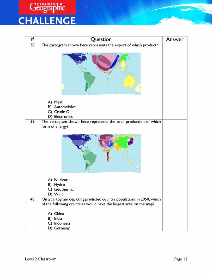
Round 6: Cartograms ( /5)
Cartograms are maps that are distorted to show a specific statistic. This
round will test your ability to relate statistical trends to cartograms.
# Question Answer 36 The cartogram shown here represents the distribution of speakers of
which language?
A) English
B) French
C) Portuguese
D) Spanish
37 The cartogram shown here represents the distribution of followers of
which religion?
A) Islam
B) Christianity
C) Buddhism
D) Hinduism
Level 2 Classroom Page 12
# Question Answer 38 The cartogram shown here represents the export of which product?
A) Meat
B) Automobiles
C) Crude Oil
D) Electronics
39 The cartogram shown here represents the total production of which
form of energy?
A) Nuclear B) Hydro
C) Geothermal
D) Wind
40 On a cartogram depicting predicted country populations in 2050, which
of the following countries would have the largest area on the map?
A) China
B) India
C) Indonesia
D) Germany

Level 2 Classroom Page 13
Round 7: Miscellaneous Trivia ( /10)
This round will test your knowledge of the world with a variety of
different geographic questions.
# Question Answer 41 The deepest lake in the world can be found in which country?
A) Canada
B) China
C) India
D) Russia
42 What is the capital of Burkina Faso?
A) Ouagadougou
B) Tegucigalpa
C) Yaoundé
D) Mbabane
43 Which country’s flag is shown here?
A) Turkey
B) Tunisia
C) Turkmenistan
D) Tajikistan
44 An enclave is a territory that is entirely surrounded by the territory of
another state. Which of the following countries is not an enclave?
A) San Marino
B) Vatican City
C) Lesotho
D) Swaziland
45 Which glacial landform is shown here?
A) Esker
B) Cirque
C) Horn
D) Drumlin

Level 2 Classroom Page 14
# Question Answer 46 More than 200 million years ago, a massive asteroid
struck Canada, forming the body of water seen in
this satellite image. What is the name of this body
of water?
A) Hudson Bay
B) Reservoir Manicouagan
C) Lake Superior
D) Great Bear Lake
47 What is the longest river in Europe?
A) Danube
B) Rhine
C) Volga
D) Loire
48 Rideau Hall is the residence of which
Canadian political figure?
A) Prime Minister
B) Chief Justice
C) Governor General
D) Speaker of the Senate
49 Which island country’s economy has declined due to the exhaustion of
its phosphate mines?
A) Singapore
B) Tuvalu
C) Nauru
D) Fiji
50 What is the most populous city not located on a major body of water?
A) Johannesburg
B) Beijing
C) Rome
D) Denver